Wear Valley, Tennessee
Submit your own pictures of this place and show them to the world
- OSM Map
- General Map
- Google Map
- MSN Map

| Males: 3,774 | |
| Females: 3,820 |
| Median resident age: | 40.1 years |
| Tennessee median age: | 35.9 years |
Zip code: 37862
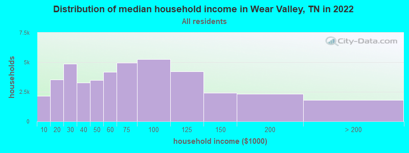
| Wear Valley: | $58,905 |
| TN: | $65,254 |
Estimated per capita income in 2022: $31,039 (it was $17,422 in 2000)
Wear Valley CCD income, earnings, and wages data
Estimated median house or condo value in 2022: $341,160 (it was $109,500 in 2000)
| Wear Valley: | $341,160 |
| TN: | $284,800 |
Mean prices in 2022: all housing units: $330,978; detached houses: $361,863; townhouses or other attached units: $370,012; in 2-unit structures: $295,632; in 3-to-4-unit structures: $389,627; in 5-or-more-unit structures: $226,888; mobile homes: $131,302; occupied boats, rvs, vans, etc.: $132,485
Detailed information about poverty and poor residents in Wear Valley, TN


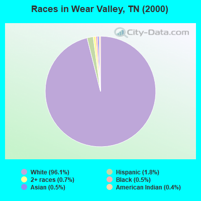
- 6,23096.1%White alone
- 1181.8%Hispanic
- 450.7%Two or more races
- 340.5%Black alone
- 340.5%Asian alone
- 240.4%American Indian alone
- 10.02%Native Hawaiian and Other
Pacific Islander alone
Races in Wear Valley detailed stats: ancestries, foreign born residents, place of birth
 Recent articles from our blog. Our writers, many of them Ph.D. graduates or candidates, create easy-to-read articles on a wide variety of topics.
Current Local Time: EST time zone
Elevation: 1454 feet
Land area: 69.7 square miles.
Population density: 109 people per square mile (very low).

| Wear Valley CCD: | 0.3% ($348) |
| Tennessee: | 0.8% ($715) |
Nearest city with pop. 50,000+: Knoxville, TN  (23.8 miles , pop. 173,890).
Nearest city with pop. 200,000+: Atlanta, GA (145.1 miles , pop. 416,474).
Nearest city with pop. 1,000,000+: Chicago, IL (474.4 miles , pop. 2,896,016).
Nearest cities:
), ), ), Latitude: 35.76 N, Longitude: 83.61 W
Area code commonly used in this area: 865

| Here: | 2.4% |
| Tennessee: | 3.0% |
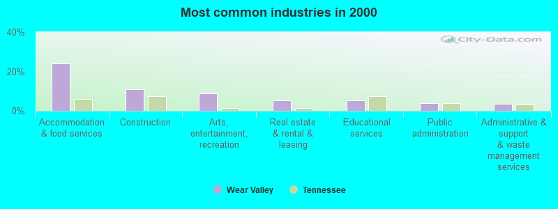
- Accommodation & food services (24.1%)
- Construction (11.1%)
- Arts, entertainment, recreation (9.0%)
- Real estate & rental & leasing (5.4%)
- Educational services (5.3%)
- Public administration (3.9%)
- Administrative & support & waste management services (3.7%)
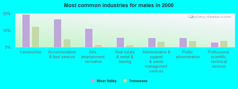
- Construction (19.6%)
- Accommodation & food services (16.8%)
- Arts, entertainment, recreation (11.1%)
- Real estate & rental & leasing (5.8%)
- Administrative & support & waste management services (5.7%)
- Public administration (5.7%)
- Professional, scientific, technical services (2.9%)
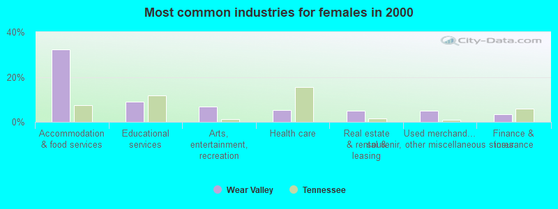
- Accommodation & food services (32.2%)
- Educational services (8.9%)
- Arts, entertainment, recreation (6.7%)
- Health care (5.2%)
- Real estate & rental & leasing (5.0%)
- Used merchandise, gift, novelty, souvenir, other miscellaneous stores (4.9%)
- Finance & insurance (3.5%)
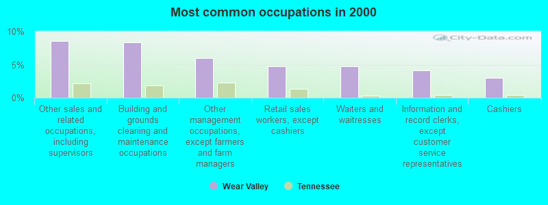
- Other sales and related occupations, including supervisors (8.5%)
- Building and grounds cleaning and maintenance occupations (8.4%)
- Other management occupations, except farmers and farm managers (5.9%)
- Retail sales workers, except cashiers (4.8%)
- Waiters and waitresses (4.7%)
- Information and record clerks, except customer service representatives (4.1%)
- Cashiers (3.0%)
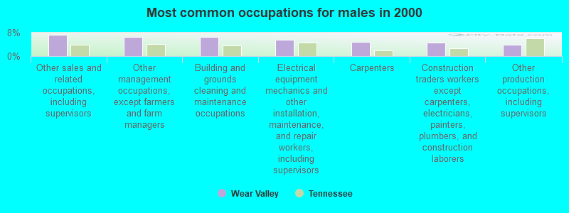
- Other sales and related occupations, including supervisors (7.2%)
- Other management occupations, except farmers and farm managers (6.4%)
- Building and grounds cleaning and maintenance occupations (6.4%)
- Electrical equipment mechanics and other installation, maintenance, and repair workers, including supervisors (5.6%)
- Carpenters (5.0%)
- Construction traders workers except carpenters, electricians, painters, plumbers, and construction laborers (4.7%)
- Other production occupations, including supervisors (3.9%)
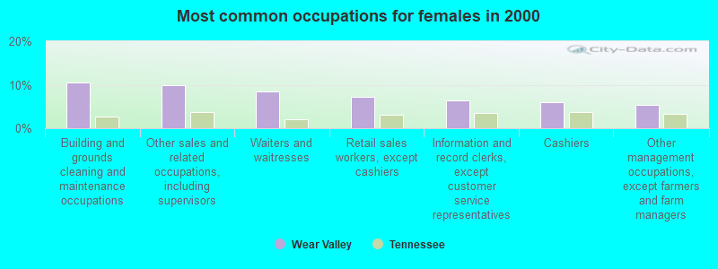
- Building and grounds cleaning and maintenance occupations (10.6%)
- Other sales and related occupations, including supervisors (10.0%)
- Waiters and waitresses (8.4%)
- Retail sales workers, except cashiers (7.2%)
- Information and record clerks, except customer service representatives (6.3%)
- Cashiers (5.9%)
- Other management occupations, except farmers and farm managers (5.4%)
Average climate in Wear Valley, Tennessee
Based on data reported by over 4,000 weather stations


(lower is better)
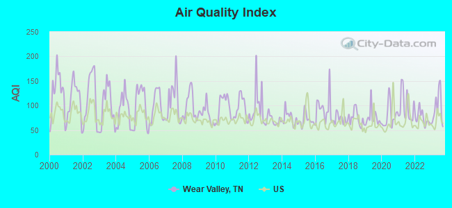
Air Quality Index (AQI) level in 2023 was 94.7. This is worse than average.
| City: | 94.7 |
| U.S.: | 72.6 |
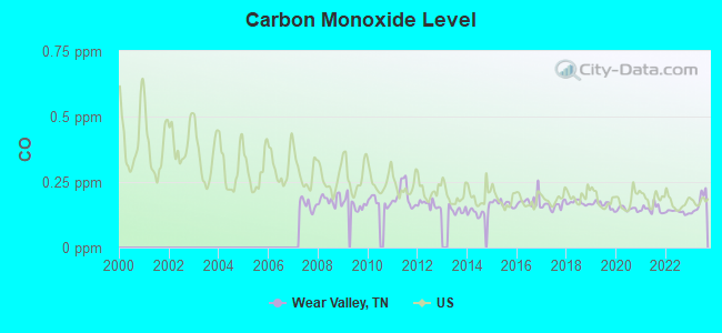
Carbon Monoxide (CO) [ppm] level in 2023 was 0.171. This is significantly better than average. Closest monitor was 20.3 miles away from the city center.
| City: | 0.171 |
| U.S.: | 0.251 |
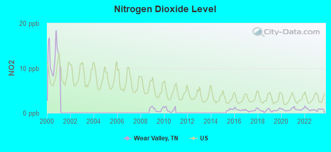
Nitrogen Dioxide (NO2) [ppb] level in 2023 was 0.751. This is significantly better than average. Closest monitor was 14.5 miles away from the city center.
| City: | 0.751 |
| U.S.: | 5.109 |
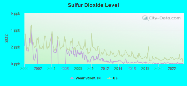
Sulfur Dioxide (SO2) [ppb] level in 2023 was 0.0574. This is significantly better than average. Closest monitor was 4.0 miles away from the city center.
| City: | 0.0574 |
| U.S.: | 1.5147 |
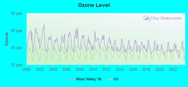
Ozone [ppb] level in 2023 was 38.0. This is about average. Closest monitor was 4.0 miles away from the city center.
| City: | 38.0 |
| U.S.: | 33.3 |
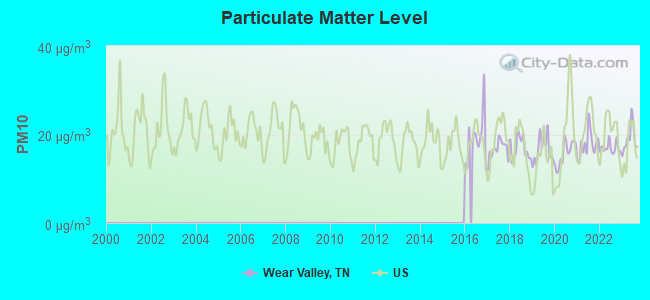
Particulate Matter (PM10) [µg/m3] level in 2023 was 18.9. This is about average. Closest monitor was 18.3 miles away from the city center.
| City: | 18.9 |
| U.S.: | 19.2 |
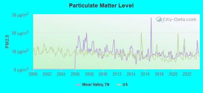
Particulate Matter (PM2.5) [µg/m3] level in 2023 was 9.70. This is about average. Closest monitor was 18.3 miles away from the city center.
| City: | 9.70 |
| U.S.: | 8.11 |
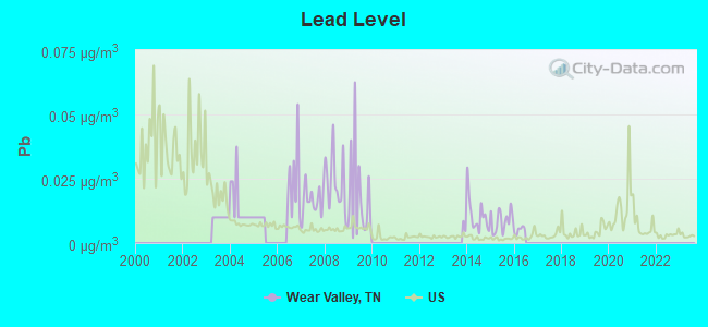
Lead (Pb) [µg/m3] level in 2015 was 0.00868. This is about average. Closest monitor was 19.0 miles away from the city center.
| City: | 0.00868 |
| U.S.: | 0.00931 |
Tornado activity:
Wear Valley-area historical tornado activity is significantly below Tennessee state average. It is 44% smaller than the overall U.S. average.
On 2/21/1993, a category F3 (max. wind speeds 158-206 mph) tornado 21.7 miles away from the Wear Valley place center killed one person and injured 55 people and caused between $5000 and $50,000 in damages.
On 4/3/1974, a category F4 (max. wind speeds 207-260 mph) tornado 45.9 miles away from the place center killed 4 people and injured 26 people and caused between $5,000,000 and $50,000,000 in damages.
Earthquake activity:
Wear Valley-area historical earthquake activity is significantly above Tennessee state average. It is 65% greater than the overall U.S. average.On 11/30/1973 at 07:48:41, a magnitude 4.7 (4.7 MB, 4.6 ML, Class: Light, Intensity: IV - V) earthquake occurred 19.8 miles away from the city center
On 8/9/2020 at 12:07:37, a magnitude 5.1 (5.1 MW, Depth: 4.7 mi, Class: Moderate, Intensity: VI - VII) earthquake occurred 149.3 miles away from Wear Valley center
On 7/27/1980 at 18:52:21, a magnitude 5.2 (5.1 MB, 4.7 MS, 5.0 UK, 5.2 UK) earthquake occurred 170.4 miles away from the city center
On 4/29/2003 at 08:59:39, a magnitude 4.9 (4.4 MB, 4.6 MW, 4.9 LG) earthquake occurred 143.6 miles away from the city center
On 8/2/1974 at 08:52:09, a magnitude 4.9 (4.3 MB, 4.9 LG) earthquake occurred 145.1 miles away from the city center
On 12/12/2018 at 09:14:43, a magnitude 4.4 (4.4 MW, Depth: 4.9 mi) earthquake occurred 63.6 miles away from Wear Valley center
Magnitude types: regional Lg-wave magnitude (LG), body-wave magnitude (MB), local magnitude (ML), surface-wave magnitude (MS), moment magnitude (MW)
Natural disasters:
The number of natural disasters in Sevier County (17) is near the US average (15).Major Disasters (Presidential) Declared: 10
Emergencies Declared: 2
Causes of natural disasters: Floods: 9, Storms: 6, Fires: 3, Heavy Rains: 3, Winter Storms: 3, Tornadoes: 2, Flash Flood: 1, Hurricane: 1, Landslide: 1, Mudslide: 1, Snowfall: 1, Wind: 1, Other: 1 (Note: some incidents may be assigned to more than one category).
Hospitals and medical centers near Wear Valley:
- PIGEON FORGE CARE AND REHAB CENTER (Nursing Home, about 4 miles away; PIGEON FORGE, TN)
- ROYAL CARE OF PIGEON FORGE (Nursing Home, about 4 miles away; PIGEON FORGE, TN)
- FORT SANDERS SEVIER NURSING HOME (Nursing Home, about 9 miles away; SEVIERVILLE, TN)
- DCI SEVIERVILLE (Dialysis Facility, about 9 miles away; SEVIERVILLE, TN)
- SEVIER CO HEALTH CARE CTR (Nursing Home, about 9 miles away; SEVIERVILLE, TN)
Colleges/universities with over 2000 students nearest to Wear Valley:
- The University of Tennessee-Knoxville (about 23 miles; Knoxville, TN; Full-time enrollment: 25,483)
- Pellissippi State Community College (about 34 miles; Knoxville, TN; FT enrollment: 7,271)
- Walters State Community College (about 38 miles; Morristown, TN; FT enrollment: 4,359)
- Western Carolina University (about 43 miles; Cullowhee, NC; FT enrollment: 8,684)
- Tusculum College (about 56 miles; Greeneville, TN; FT enrollment: 2,070)
- Roane State Community College (about 58 miles; Harriman, TN; FT enrollment: 4,302)
- Lincoln Memorial University (about 58 miles; Harrogate, TN; FT enrollment: 3,706)
Points of interest:
Notable locations in Wear Valley: Trotter Camp (A), Waldens Creek Volunteer Fire Department (B), Wears Valley Volunteer Fire Department (C). Display/hide their locations on the map
Churches in Wear Valley include: Laurel Grove Church (A), Hurst Chapel (B), Friendship Church (C), Covemont Church (D), Valley View Church (E), Headrick Chapel (F), Wear Valley Church (G), Chinquapin Church (H), Waldens Creek United Methodist Church (I). Display/hide their locations on the map
Cemeteries: White Oak Grove Cemetery (1), Waldens Creek Cemetery (2), Valley View Cemetery (3), Little Cove Cemetery (4), Laurel Grove Cemetery (5), Hurst Chapel Cemetery (6), Headrick Chapel Cemetery (7). Display/hide their locations on the map
Reservoir: Margerita Craig Lake (A). Display/hide its location on the map
Streams, rivers, and creeks: Machine Branch (A), Lost Branch (B), Long Branch (C), Lick Branch (D), Laurel Creek (E), King Hollow Branch (F), Whiteoak Branch (G), Dry Fork (H), Cove Creek (I). Display/hide their locations on the map
| This place: | 2.5 people |
| Tennessee: | 2.5 people |
| This place: | 63.3% |
| Whole state: | 69.8% |
| This place: | 3.9% |
| Whole state: | 4.2% |
Likely homosexual households (counted as self-reported same-sex unmarried-partner households)
- Lesbian couples: 0.2% of all households
- Gay men: 0.2% of all households
| This place: | 11.4% |
| Whole state: | 13.5% |
| This place: | 3.7% |
| Whole state: | 5.8% |
For population 15 years and over in Wear Valley:
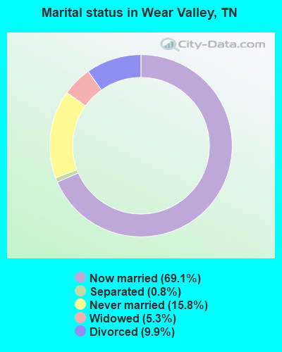
- Never married: 15.8%
- Now married: 69.1%
- Separated: 0.8%
- Widowed: 5.3%
- Divorced: 9.9%
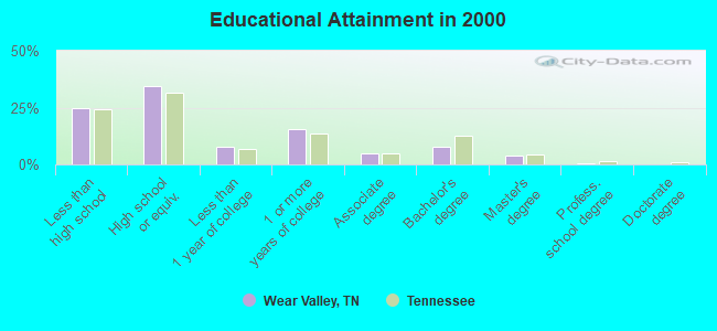
For population 25 years and over in Wear Valley:
- High school or higher: 75.3%
- Bachelor's degree or higher: 12.2%
- Graduate or professional degree: 4.4%
- Unemployed: 5.9%
- Mean travel time to work (commute): 21.5 minutes
| Here: | 11.7 |
| Tennessee average: | 13.3 |
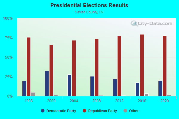
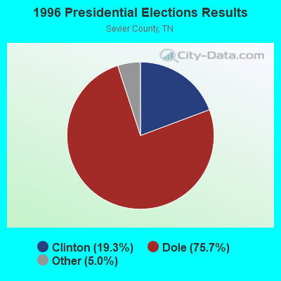

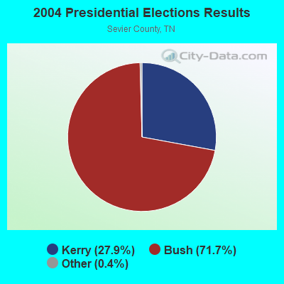

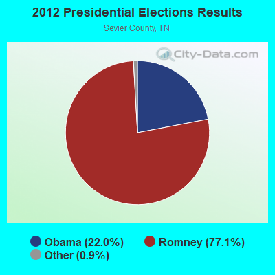
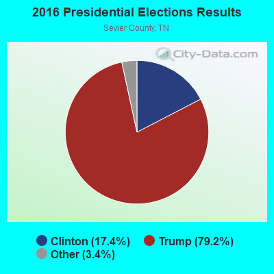
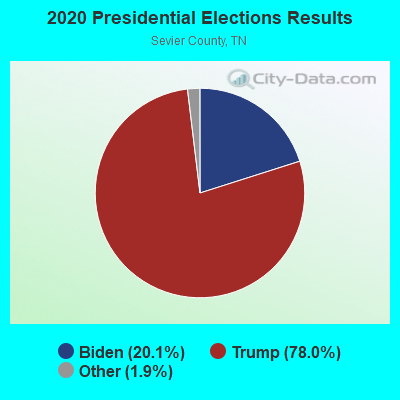
Graphs represent county-level data. Detailed 2008 Election Results
Religion statistics for Wear Valley, TN (based on Sevier County data)
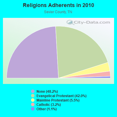
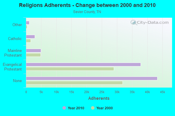
| Religion | Adherents | Congregations |
|---|---|---|
| Evangelical Protestant | 37,789 | 110 |
| Mainline Protestant | 4,938 | 29 |
| Catholic | 2,846 | 3 |
| Other | 1,016 | 5 |
| None | 43,300 | - |
Food Environment Statistics:
| This county: | 2.51 / 10,000 pop. |
| Tennessee: | 1.99 / 10,000 pop. |
| This county: | 0.12 / 10,000 pop. |
| State: | 0.17 / 10,000 pop. |
| Sevier County: | 1.20 / 10,000 pop. |
| State: | 0.65 / 10,000 pop. |
| Here: | 8.50 / 10,000 pop. |
| State: | 5.16 / 10,000 pop. |
| Here: | 15.57 / 10,000 pop. |
| Tennessee: | 6.56 / 10,000 pop. |
| Sevier County: | 10.8% |
| State: | 11.4% |
| Here: | 27.3% |
| Tennessee: | 30.2% |
| Here: | 13.6% |
| Tennessee: | 13.5% |
Strongest AM radio stations in Wear Valley:
- WKVL (850 AM; daytime; 50 kW; KNOXVILLE, TN; Owner: HORNE RADIO, LLC)
- WSEV (930 AM; 5 kW; SEVIERVILLE, TN; Owner: EAST TENNESSEE RADIO GROUP, L.P.)
- WVLZ (1180 AM; daytime; 10 kW; KNOXVILLE, TN; Owner: KIRKLAND WIRELESS BROADCASTERS, INC.)
- WRJZ (620 AM; 5 kW; KNOXVILLE, TN; Owner: TENNESSEE MEDIA ASSOCIATES, INC)
- WNOX (990 AM; 10 kW; KNOXVILLE, TN)
- WQBB (1040 AM; daytime; 10 kW; POWELL, TN; Owner: JOURNAL BROADCAST CORPORATION)
- WFGW (1010 AM; 50 kW; BLACK MOUNTAIN, NC; Owner: BLUE RIDGE BROADCASTING CORP.)
- WLFJ (660 AM; daytime; 50 kW; GREENVILLE, SC; Owner: CLEAR CHANNEL BROADCASTING LICENSES, INC.)
- WKCE (1120 AM; daytime; 1 kW; MARYVILLE, TN; Owner: KIRKLAND WIRELESS BROADCASTERS, INC.)
- WMEN (760 AM; daytime; 2 kW; KNOXVILLE, TN; Owner: THOMAS MOFFIT JR.)
- WCSZ (1070 AM; 50 kW; SANS SOUCI, SC; Owner: WHYZ RADIO, L.P.)
- WLIK (1270 AM; 5 kW; NEWPORT, TN; Owner: WLIK, INC)
- WKJV (1380 AM; 25 kW; ASHEVILLE, NC; Owner: INTERNATIONAL BAPTIST OUTREACH MISSIONS)
Strongest FM radio stations in Wear Valley:
- WIVK-FM (107.7 FM; KNOXVILLE, TN; Owner: CITADEL BROADCASTING COMPANY)
- WWST (102.1 FM; SEVIERVILLE, TN; Owner: JOURNAL BROADCAST CORPORATION)
- WSEV-FM (105.5 FM; GATLINBURG, TN; Owner: EAST TENNESSEE RADIO GROUP, L.P.)
- WOKI-FM (100.3 FM; OAK RIDGE, TN; Owner: OAK RIDGE FM, INC.)
- WUOT (91.9 FM; KNOXVILLE, TN; Owner: UNIVERSITY OF TENNESSEE)
- WIMZ-FM (103.5 FM; KNOXVILLE, TN; Owner: SOUTH CENTRAL COMM., CORP.)
- W237AR (95.3 FM; HAZELWOOD, ETC., NC; Owner: WESTERN NORTH CAROLINA PUBLIC RADIO)
- WJXB-FM (97.5 FM; KNOXVILLE, TN; Owner: SOUTH CENTRAL COMMUNICATIONS CORP.)
- WCVP-FM (95.9 FM; ROBBINSVILLE, NC; Owner: CHEROKEE BROADCASTING COMPANY, INC.)
- WFQS (91.3 FM; FRANKLIN, NC; Owner: WESTERN NORTH CAROLINA PUBLIC RADIO)
- WJBZ-FM (96.3 FM; SEYMOUR, TN; Owner: SEYMOUR COMMUNICATIONS)
- W266AA (101.1 FM; KODAK, TN; Owner: SOUTH CENTRAL COMMUNICATIONS CORP.)
- WYLV (89.1 FM; ALCOA, TN; Owner: FOOTHILLS BROADCASTING, INC.)
- WKSF (99.9 FM; ASHEVILLE, NC; Owner: CAPSTAR TX LIMITED PARTNERSHIP)
- WDVX (89.9 FM; CLINTON, TN; Owner: CUMBERLAND COMMUNITIES COMMUNI CORP.)
- WQNS (104.9 FM; WAYNESVILLE, NC; Owner: CLEAR CHANNEL BROADCASTING LICENSES, INC.)
- WEZG (99.3 FM; JEFFERSON CITY, TN; Owner: EAST TENNESSEE RADIO GROUP, L.P.)
- WNCC-FM (96.7 FM; FRANKLIN, NC; Owner: SUTTON RADIOCASTING CORPORATION)
- W220CD (91.9 FM; ENKA, NC; Owner: CALVARY CHAPEL OF TWIN FALLS, INC.)
- WMIT (106.9 FM; BLACK MOUNTAIN, NC; Owner: BLUE RIDGE BROADCASTING CORPORATION)
TV broadcast stations around Wear Valley:
- WKOP-TV (Channel 15; KNOXVILLE, TN; Owner: EAST TENNESSEE PUBLIC COMMUNICATIONS CORP.)
- WVLT-TV (Channel 8; KNOXVILLE, TN; Owner: WVLT LICENSEE CORP.)
- WBIR-TV (Channel 10; KNOXVILLE, TN; Owner: GANNETT PACIFIC CORPORATION)
- WATE-TV (Channel 6; KNOXVILLE, TN; Owner: WATE, G.P.)
- WTNZ (Channel 43; KNOXVILLE, TN; Owner: RAYCOM AMERICA, INC.)
- WJZC-LP (Channel 22; SEVIERVILLE, TN; Owner: SOUTH CENTRAL COMMUNICATIONS CORP.)
- W50AB (Channel 50; HIAWASSEE, GA; Owner: GEORGIA PUBLIC TELECOMMUNICATIONS COMMISSION)
- WEEE-LP (Channel 32; KNOXVILLE, TN; Owner: TIGER EYE BROADCASTING CORPORATION)
- WDTT-LP (Channel 38; LENOIR CITY, TN; Owner: WORD OF GOD FELLOWSHIP, INC.)
- WEZK-LP (Channel 28; KNOXVILLE, TN; Owner: SOUTH CENTRAL COMMUNICATIONS CORP.)
- W46DC (Channel 46; KNOXVILLE, TN; Owner: TRINITY BROADCASTING NETWORK)
- W50CG (Channel 50; KNOXVILLE, TN; Owner: THREE ANGELS BROADCASTING NETWORK, INC.)
- W56CM (Channel 56; KNOXVILLE, TN; Owner: VENTANA TELEVISION, INC.)
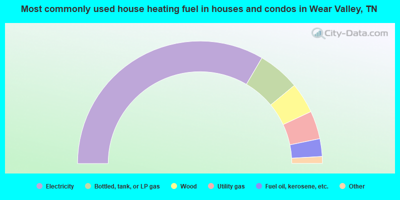
- 66.9%Electricity
- 11.1%Bottled, tank, or LP gas
- 8.1%Wood
- 7.4%Utility gas
- 4.7%Fuel oil, kerosene, etc.
- 0.8%No fuel used
- 0.5%Coal or coke
- 0.4%Other fuel
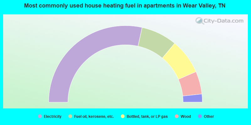
- 56.9%Electricity
- 15.1%Fuel oil, kerosene, etc.
- 14.9%Bottled, tank, or LP gas
- 9.6%Wood
- 1.7%Utility gas
- 1.7%No fuel used
Wear Valley compared to Tennessee state average:
- Unemployed percentage below state average.
- Black race population percentage significantly below state average.
- Hispanic race population percentage significantly below state average.
- Foreign-born population percentage significantly below state average.
- Renting percentage significantly below state average.
- Length of stay since moving in significantly above state average.
- Number of rooms per house significantly below state average.
- House age significantly below state average.
- Institutionalized population percentage significantly above state average.
- Number of college students below state average.
- Percentage of population with a bachelor's degree or higher below state average.
Wear Valley on our top lists:
- #2 on the list of "Top 101 cities with largest percentage of females in occupations: waiters and waitresses (population 5,000+)"
- #4 on the list of "Top 101 cities with largest percentage of females in industries: accommodation and food services (population 5,000+)"
- #4 on the list of "Top 101 cities with largest percentage of females in industries: used merchandise, gift, novelty, and souvenir, and other miscellaneous stores (population 5,000+)"
- #6 on the list of "Top 101 cities with largest percentage of males in occupations: personal appearance workers (population 5,000+)"
- #6 on the list of "Top 101 cities with largest percentage of females in industries: jewelry, luggage, and leather goods stores (population 5,000+)"
- #7 on the list of "Top 101 cities with largest percentage of females in occupations: other sales and related workers including supervisors (population 5,000+)"
- #10 on the list of "Top 101 cities with largest percentage of males in occupations: entertainers and performers, sports, and related workers (population 5,000+)"
- #15 on the list of "Top 101 cities with largest percentage of males in occupations: supervisors and other personal care and service workers except personal appearance, transportation, and child care workers (population 5,000+)"
- #16 on the list of "Top 101 cities with largest percentage of males in industries: jewelry, luggage, and leather goods stores (population 5,000+)"
- #19 on the list of "Top 101 cities with largest percentage of females in occupations: food processing workers (population 5,000+)"
- #21 on the list of "Top 101 cities with largest percentage of females in industries: gasoline stations (population 5,000+)"
- #24 on the list of "Top 101 cities with largest percentage of males in industries: personal and laundry services (population 5,000+)"
- #25 on the list of "Top 101 cities with largest percentage of females in industries: furniture and home furnishings, and household appliance stores (population 5,000+)"
- #66 on the list of "Top 101 cities with largest percentage of males in industries: textile mills and textile products (population 5,000+)"
- #70 on the list of "Top 101 cities with largest percentage of males in industries: used merchandise, gift, novelty, and souvenir, and other miscellaneous stores (population 5,000+)"
- #76 on the list of "Top 101 cities with largest percentage of males in industries: arts, entertainment, and recreation (population 5,000+)"
- #6 on the list of "Top 101 counties with the lowest Sulfur Oxides Annual air pollution readings in 2012 (µg/m3)"
- #17 on the list of "Top 101 counties with the highest Ozone (1-hour) air pollution readings in 2012 (ppm)"
- #25 on the list of "Top 101 counties with highest percentage of residents voting for Romney (Republican) in the 2012 Presidential Election (pop. 50,000+)"
- #72 on the list of "Top 101 counties with the lowest ground withdrawal of fresh water for public supply (pop. 50,000+)"