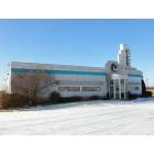
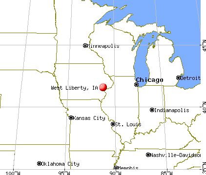
West Liberty, Iowa

Submit your own pictures of this city and show them to the world
- OSM Map
- General Map
- Google Map
- MSN Map
Population change since 2000: +12.6%
 |
| Males: 1,869 | |
| Females: 1,882 |
| Median resident age: | 33.9 years |
| Iowa median age: | 38.9 years |
Zip codes: 52776.
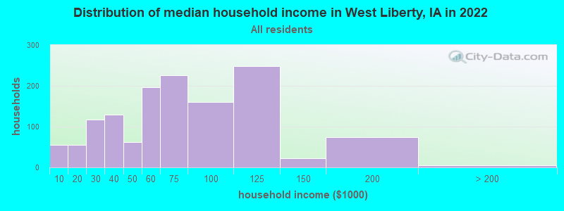
| West Liberty: | $63,020 |
| IA: | $69,588 |
Estimated per capita income in 2022: $26,441 (it was $15,420 in 2000)
West Liberty city income, earnings, and wages data
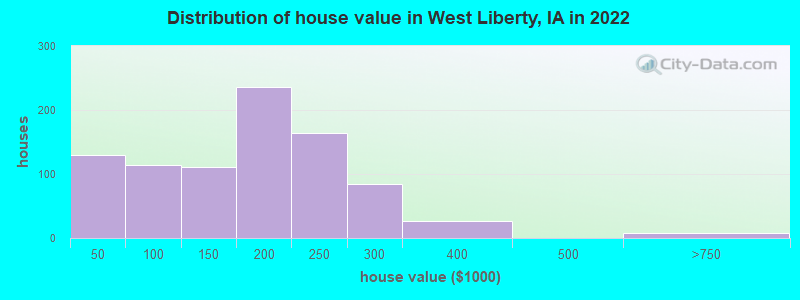
Estimated median house or condo value in 2022: $168,882 (it was $83,000 in 2000)
| West Liberty: | $168,882 |
| IA: | $194,600 |
Mean prices in 2022: all housing units: $202,549; detached houses: $209,734; townhouses or other attached units: $196,544; mobile homes: $30,935
Median gross rent in 2022: $936.
(8.1% for White Non-Hispanic residents, 27.0% for Black residents, 4.5% for Hispanic or Latino residents, 87.5% for American Indian residents, 9.5% for other race residents)
Detailed information about poverty and poor residents in West Liberty, IA

Compare current foreclosures near West Liberty, IA:
| Photo | Address | Area | Beds / Baths | Price | Details |
|---|---|---|---|---|---|

|
#1
N Miller St
West Liberty, IA 52776
|
1,602 sq. feet
|
1 baths 4 beds |
show details | |

|
#2
Old Highway 61
Muscatine, IA 52761
|
2,623 sq. feet
|
2 baths 4 beds |
$314,900
|
show details |

|
#3
Clinton St
Muscatine, IA 52761
|
1,076 sq. feet
|
1 baths 2 beds |
$159,500
|
show details |

|
#4
Mulberry St
Tipton, IA 52772
|
2,452 sq. feet
|
2 baths 5 beds |
show details | |

|
#5
Cypress St
Muscatine, IA 52761
|
1,117 sq. feet
|
1 baths 3 beds |
show details | |

|
#6
Mulberry Ave
Muscatine, IA 52761
|
1,201 sq. feet
|
1 baths 3 beds |
show details | |

|
#7
E 7th St
Tipton, IA 52772
|
1,732 sq. feet
|
1 baths 4 beds |
show details | |

|
#8
Sweetland Rd
Muscatine, IA 52761
|
2,123 sq. feet
|
2 baths 3 beds |
show details | |

|
#9
Bryan Ave
Muscatine, IA 52761
|
2,720 sq. feet
|
1 baths 3 beds |
show details | |

|
#10
Grand Ave
Muscatine, IA 52761
|
1,247 sq. feet
|
1 baths 3 beds |
show details |
| Photo | Address | Area | Beds / Baths | Price | Details |
|---|---|---|---|---|---|

|
#11
Broadway St
Nichols, IA 52766
|
1,330 sq. feet
|
1 baths 3 beds |
show details | |

|
#12
Busch St
Muscatine, IA 52761
|
1,696 sq. feet
|
2 baths 3 beds |
show details | |

|
#13
Center St
Fruitland, IA 52749
|
1,149 sq. feet
|
2 baths 3 beds |
show details | |

|
#14
Hershey Ave
Muscatine, IA 52761
|
1,352 sq. feet
|
1 baths 3 beds |
show details | |

|
#15
W 6th St
Muscatine, IA 52761
|
1,218 sq. feet
|
1 baths 2 beds |
show details | |

|
#16
Sherman St
Muscatine, IA 52761
|
1,228 sq. feet
|
1 baths 2 beds |
show details | |

|
#17
W 2nd St
Tipton, IA 52772
|
1,575 sq. feet
|
1 baths 4 beds |
show details | |

|
#18
Cobblestone Dr
Muscatine, IA 52761
|
1,552 sq. feet
|
1 baths 3 beds |
show details | |

|
#19
Buell St
Muscatine, IA 52761
|
1,325 sq. feet
|
1 baths 3 beds |
show details | |

|
#20
Locust St
Tipton, IA 52772
|
1,953 sq. feet
|
1 baths 3 beds |
show details |
| Photo | Address | Area | Beds / Baths | Price | Details |
|---|---|---|---|---|---|

|
#21
E 4th St
Tipton, IA 52772
|
1,596 sq. feet
|
1 baths 3 beds |
show details | |

|
#22
Park Ave
Muscatine, IA 52761
|
1,448 sq. feet
|
1 baths 4 beds |
show details | |

|
#23
E 2nd St
Tipton, IA 52772
|
937 sq. feet
|
1 baths 2 beds |
show details | |

|
#24
Iowa Ave
Muscatine, IA 52761
|
1,336 sq. feet
|
1 baths 3 beds |
show details | |

|
#25
Devitt Ave
Muscatine, IA 52761
|
2,604 sq. feet
|
1 baths 3 beds |
show details | |

|
#26
290th St
Atalissa, IA 52720
|
982 sq. feet
|
1 baths 3 beds |
show details | |

|
#27
Hummingbird Ln
Muscatine, IA 52761
|
2,370 sq. feet
|
1 baths 4 beds |
show details | |

|
#28
Lexington Ave
Iowa City, IA 52246
|
2,508 sq. feet
|
- baths 8 beds |
show details | |

|
#29
Broadway St
Iowa City, IA 52240
|
1,288 sq. feet
|
- baths 7 beds |
show details | |

|
#30
Gleason Dr
Iowa City, IA 52240
|
1,326 sq. feet
|
- baths 8 beds |
show details |
| Photo | Address | Area | Beds / Baths | Price | Details |
|---|---|---|---|---|---|

|
#31
Hollywood Ct
Iowa City, IA 52240
|
828 sq. feet
|
- baths 5 beds |
show details | |

|
#32
Hemingway Ln
Iowa City, IA 52240
|
1,656 sq. feet
|
- baths 9 beds |
show details | |

|
#33
Grantwood St
Iowa City, IA 52240
|
1,040 sq. feet
|
- baths 6 beds |
show details | |

|
#34
2nd Ave
Iowa City, IA 52240
|
925 sq. feet
|
- baths 7 beds |
show details | |

|
#35
Regal Ln
Iowa City, IA 52240
|
913 sq. feet
|
- baths 6 beds |
show details | |

|
#36
Cardigan Ln
Iowa City, IA 52245
|
- sq. feet
|
- baths - beds |
show details | |

|
#37
Colorado St, Apt 310
Muscatine, IA 52761
|
- sq. feet
|
- baths - beds |
show details | |

|
#38
Mosswood Ln
Iowa City, IA 52246
|
- sq. feet
|
- baths - beds |
show details | |

|
#39
Davis St
Iowa City, IA 52240
|
- sq. feet
|
- baths - beds |
show details | |

|
#40
285th St
Tipton, IA 52772
|
- sq. feet
|
- baths - beds |
show details |
| Photo | Address | Area | Beds / Baths | Price | Details |
|---|---|---|---|---|---|

|
#41
Eisenhower St
West Branch, IA 52358
|
- sq. feet
|
- baths - beds |
show details | |

|
#42
Melrose Ave
Iowa City, IA 52246
|
2,708 sq. feet
|
- baths - beds |
show details | |

|
#43
Oakcrest St Apt 1
Iowa City, IA 52246
|
- sq. feet
|
- baths - beds |
show details | |

|
#44
York St
Wilton, IA 52778
|
- sq. feet
|
- baths - beds |
show details | |

|
#45
Cyril Ave
Muscatine, IA 52761
|
- sq. feet
|
- baths - beds |
show details | |

|
#46
Unbridled Ave
Iowa City, IA 52240
|
- sq. feet
|
- baths - beds |
show details | |

|
#47
Steamboat Way Apt 4
Muscatine, IA 52761
|
- sq. feet
|
- baths - beds |
show details | |

|
#48
Paddock Cir
Iowa City, IA 52240
|
- sq. feet
|
- baths - beds |
show details | |

|
#49
Apple Ct
Iowa City, IA 52240
|
- sq. feet
|
- baths - beds |
show details | |

|
Check over 1 million property listings on Foreclosure.com!
|
browse all offers | |||


- 2,03253.0%Hispanic
- 1,64642.9%White alone
- 1233.2%Black alone
- 621.6%Other race alone
- 360.9%Two or more races
- 170.4%Asian alone
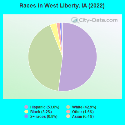
Races in West Liberty detailed stats: ancestries, foreign born residents, place of birth
According to our research of Iowa and other state lists, there were 2 registered sex offenders living in West Liberty, Iowa as of April 27, 2024.
The ratio of all residents to sex offenders in West Liberty is 1,885 to 1.
The ratio of registered sex offenders to all residents in this city is much lower than the state average.
Type |
2009 |
2010 |
2011 |
2012 |
2013 |
2014 |
2015 |
2016 |
2017 |
2020 |
2021 |
2022 |
|---|---|---|---|---|---|---|---|---|---|---|---|---|
| Murders (per 100,000) | 0 (0.0) | 0 (0.0) | 0 (0.0) | 0 (0.0) | 0 (0.0) | 0 (0.0) | 0 (0.0) | 0 (0.0) | 0 (0.0) | 0 (0.0) | 0 (0.0) | 0 (0.0) |
| Rapes (per 100,000) | 0 (0.0) | 0 (0.0) | 2 (53.2) | 4 (106.5) | 0 (0.0) | 1 (26.9) | 3 (80.5) | 6 (161.2) | 0 (0.0) | 2 (53.1) | 1 (26.8) | 2 (52.7) |
| Robberies (per 100,000) | 0 (0.0) | 0 (0.0) | 0 (0.0) | 1 (26.6) | 0 (0.0) | 0 (0.0) | 0 (0.0) | 0 (0.0) | 0 (0.0) | 1 (26.5) | 0 (0.0) | 0 (0.0) |
| Assaults (per 100,000) | 2 (54.3) | 2 (53.5) | 1 (26.6) | 2 (53.2) | 7 (187.7) | 4 (107.4) | 4 (107.3) | 5 (134.3) | 2 (53.8) | 7 (185.8) | 8 (214.4) | 8 (210.7) |
| Burglaries (per 100,000) | 19 (515.6) | 26 (695.9) | 9 (239.6) | 12 (319.4) | 15 (402.3) | 6 (161.1) | 7 (187.8) | 9 (241.7) | 6 (161.5) | 6 (159.2) | 6 (160.8) | 4 (105.4) |
| Thefts (per 100,000) | 39 (1,058) | 31 (829.8) | 31 (825.3) | 32 (851.7) | 24 (643.6) | 26 (698.2) | 14 (375.5) | 18 (483.5) | 8 (215.3) | 13 (345.0) | 12 (321.5) | 11 (289.8) |
| Auto thefts (per 100,000) | 4 (108.5) | 2 (53.5) | 1 (26.6) | 0 (0.0) | 1 (26.8) | 1 (26.9) | 1 (26.8) | 1 (26.9) | 0 (0.0) | 4 (106.2) | 1 (26.8) | 1 (26.3) |
| Arson (per 100,000) | 0 (0.0) | 0 (0.0) | 0 (0.0) | 0 (0.0) | 1 (26.8) | 0 (0.0) | 0 (0.0) | 0 (0.0) | 0 (0.0) | 0 (0.0) | 0 (0.0) | 0 (0.0) |
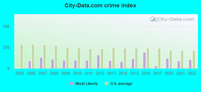
| City-Data.com crime index | 98.0 | 96.9 | 99.8 | 160.2 | 93.6 | 84.3 | 116.1 | 194.2 | 30.7 | 121.0 | 90.6 | 105.4 |
The City-Data.com crime index weighs serious crimes and violent crimes more heavily. Higher means more crime, U.S. average is 246.1. It adjusts for the number of visitors and daily workers commuting into cities.
Crime rate in West Liberty detailed stats: murders, rapes, robberies, assaults, burglaries, thefts, arson
Full-time law enforcement employees in 2020, including police officers: 6 (6 officers - 5 male; 1 female).
| Officers per 1,000 residents here: | 1.59 |
| Iowa average: | 1.76 |
 Recent articles from our blog. Our writers, many of them Ph.D. graduates or candidates, create easy-to-read articles on a wide variety of topics.

 | Ames, Cedar Rapids, or Dubuque: Which one is the best city for blue-collar jobs? (3 replies) |
| what to do in iowa city (3 replies) |
| Small towns near Coralville (8 replies) |
| Country living for Grad Student (4 replies) |
| Farm/Country-style house rental near Iowa City (7 replies) |
| North Liberty or Iowa City for families? (13 replies) |
Latest news from West Liberty, IA collected exclusively by city-data.com from local newspapers, TV, and radio stations
Ancestries: German (9.3%), African (3.1%), American (2.7%), Irish (2.2%).
Current Local Time: CST time zone
Incorporated on 07/1/1867
Elevation: 676 feet
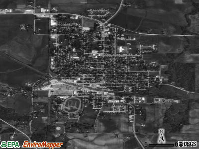
Land area: 1.56 square miles.
Population density: 2,405 people per square mile (low).
789 residents are foreign born (17.6% Latin America, 2.4% Africa).
| This city: | 20.6% |
| Iowa: | 5.6% |
Median real estate property taxes paid for housing units with mortgages in 2022: $3,018 (1.7%)
Median real estate property taxes paid for housing units with no mortgage in 2022: $2,335 (2.2%)
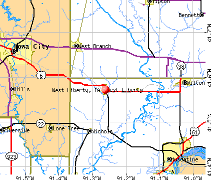
Nearest city with pop. 50,000+: Iowa City, IA  (14.8 miles , pop. 62,220).
Nearest city with pop. 200,000+: Madison, WI (141.1 miles , pop. 208,054).
Nearest city with pop. 1,000,000+: Chicago, IL (185.9 miles , pop. 2,896,016).
Nearest cities:
), ), ), )Latitude: 41.57 N, Longitude: 91.26 W
Area code: 319
West Liberty, Iowa accommodation & food services, arts - Economy and Business Data
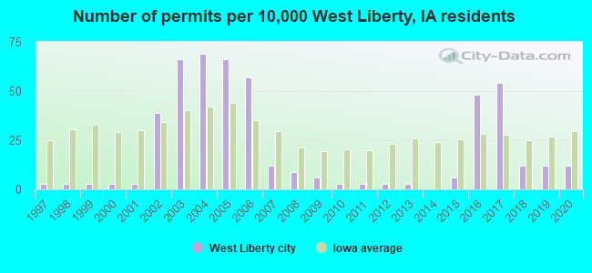
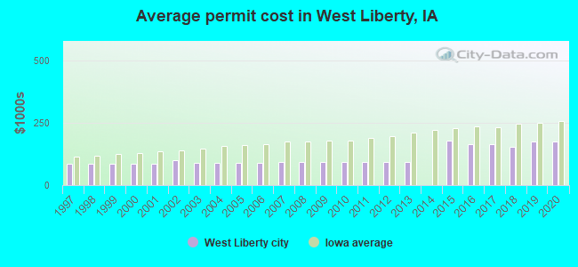
Single-family new house construction building permits:
- 2020: 4 buildings, average cost: $173,600
- 2019: 4 buildings, average cost: $173,600
- 2018: 4 buildings, average cost: $153,300
- 2017: 18 buildings, average cost: $166,100
- 2016: 16 buildings, average cost: $166,100
- 2015: 2 buildings, average cost: $180,000
- 2013: 1 building, cost: $92,500
- 2012: 1 building, cost: $92,500
- 2011: 1 building, cost: $92,500
- 2010: 1 building, cost: $92,500
- 2009: 2 buildings, average cost: $92,500
- 2008: 3 buildings, average cost: $92,500
- 2007: 4 buildings, average cost: $92,500
- 2006: 19 buildings, average cost: $88,100
- 2005: 22 buildings, average cost: $88,100
- 2004: 23 buildings, average cost: $88,100
- 2003: 22 buildings, average cost: $88,100
- 2002: 13 buildings, average cost: $101,300
- 2001: 1 building, cost: $85,000
- 2000: 1 building, cost: $85,000
- 1999: 1 building, cost: $85,000
- 1998: 1 building, cost: $85,000
- 1997: 1 building, cost: $85,000
| Here: | 2.9% |
| Iowa: | 2.7% |
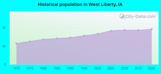
Population change in the 1990s: +375 (+12.7%).
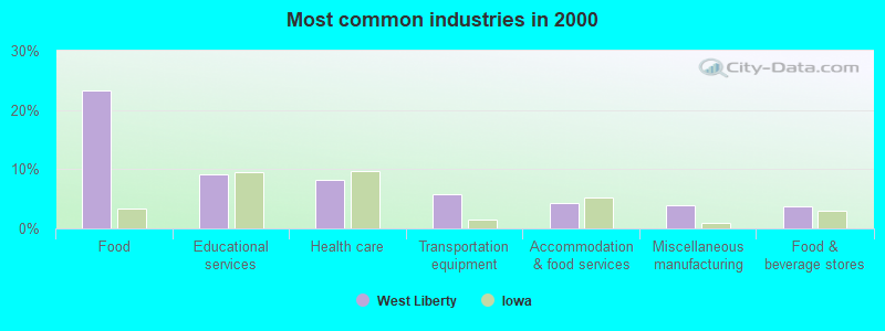
- Food (23.2%)
- Educational services (9.2%)
- Health care (8.2%)
- Transportation equipment (5.8%)
- Accommodation & food services (4.2%)
- Miscellaneous manufacturing (4.0%)
- Food & beverage stores (3.7%)
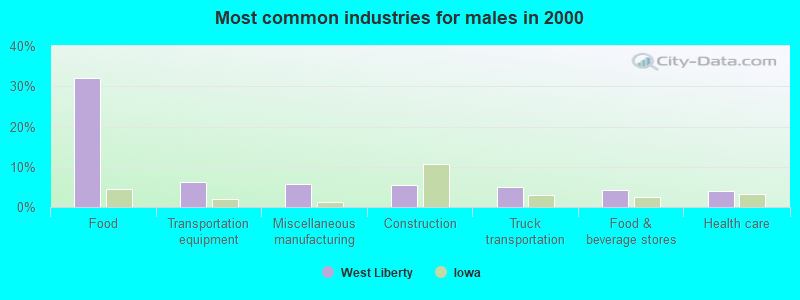
- Food (32.0%)
- Transportation equipment (6.2%)
- Miscellaneous manufacturing (5.6%)
- Construction (5.4%)
- Truck transportation (4.9%)
- Food & beverage stores (4.1%)
- Health care (4.0%)
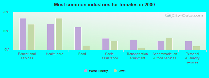
- Educational services (16.7%)
- Health care (13.7%)
- Food (12.0%)
- Social assistance (6.0%)
- Transportation equipment (5.3%)
- Accommodation & food services (4.7%)
- Personal & laundry services (4.6%)

- Other production occupations, including supervisors (11.8%)
- Laborers and material movers, hand (9.1%)
- Food processing workers (5.5%)
- Preschool, kindergarten, elementary, and middle school teachers (3.7%)
- Driver/sales workers and truck drivers (3.5%)
- Assemblers and fabricators (3.2%)
- Other management occupations, except farmers and farm managers (3.0%)
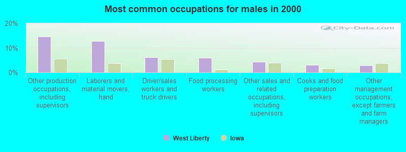
- Other production occupations, including supervisors (14.7%)
- Laborers and material movers, hand (12.8%)
- Driver/sales workers and truck drivers (6.2%)
- Food processing workers (6.1%)
- Other sales and related occupations, including supervisors (4.4%)
- Cooks and food preparation workers (3.1%)
- Other management occupations, except farmers and farm managers (3.0%)
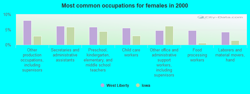
- Other production occupations, including supervisors (8.1%)
- Secretaries and administrative assistants (6.2%)
- Preschool, kindergarten, elementary, and middle school teachers (5.9%)
- Child care workers (5.6%)
- Other office and administrative support workers, including supervisors (4.7%)
- Food processing workers (4.7%)
- Laborers and material movers, hand (4.3%)
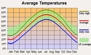
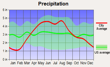
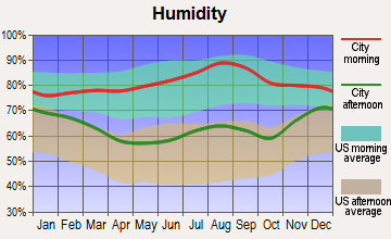
Average climate in West Liberty, Iowa
Based on data reported by over 4,000 weather stations

|
|

(lower is better)
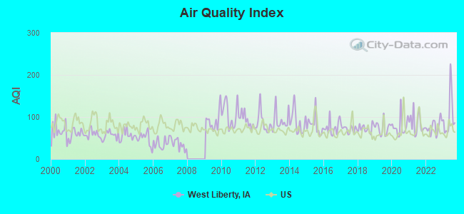
Air Quality Index (AQI) level in 2023 was 103. This is significantly worse than average.
| City: | 103 |
| U.S.: | 73 |
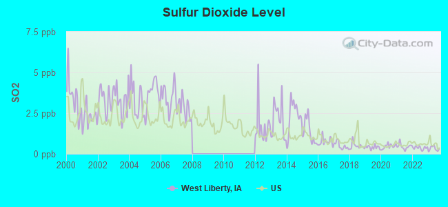
Sulfur Dioxide (SO2) [ppb] level in 2023 was 0.323. This is significantly better than average. Closest monitor was 13.4 miles away from the city center.
| City: | 0.323 |
| U.S.: | 1.515 |
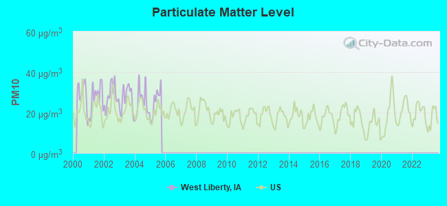
Particulate Matter (PM10) [µg/m3] level in 2005 was 25.3. This is worse than average. Closest monitor was 13.9 miles away from the city center.
| City: | 25.3 |
| U.S.: | 19.2 |
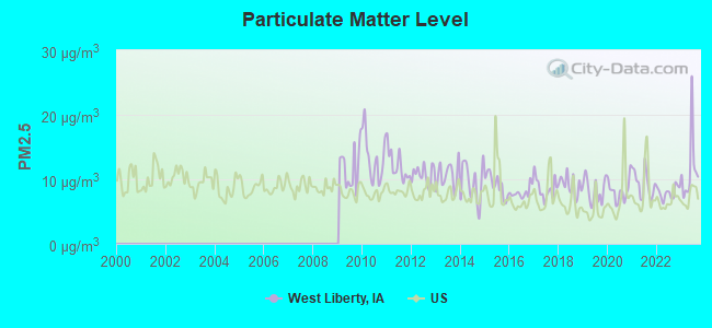
Particulate Matter (PM2.5) [µg/m3] level in 2023 was 11.5. This is significantly worse than average. Closest monitor was 13.9 miles away from the city center.
| City: | 11.5 |
| U.S.: | 8.1 |
Tornado activity:
West Liberty-area historical tornado activity is near Iowa state average. It is 89% greater than the overall U.S. average.
On 4/11/1965, a category F4 (max. wind speeds 207-260 mph) tornado 25.8 miles away from the West Liberty city center killed one person and injured 3 people and caused between $500,000 and $5,000,000 in damages.
On 6/7/1984, a category F4 tornado 30.5 miles away from the city center killed 3 people and injured 64 people and caused between $5,000,000 and $50,000,000 in damages.
Earthquake activity:
West Liberty-area historical earthquake activity is significantly above Iowa state average. It is 144% greater than the overall U.S. average.On 4/18/2008 at 09:36:59, a magnitude 5.4 (5.1 MB, 4.8 MS, 5.4 MW, 5.2 MW, Class: Moderate, Intensity: VI - VII) earthquake occurred 280.2 miles away from the city center
On 6/10/1987 at 23:48:54, a magnitude 5.1 (4.9 MB, 4.4 MS, 4.6 MS, 5.1 LG) earthquake occurred 260.7 miles away from the city center
On 4/18/2008 at 09:36:59, a magnitude 5.2 (5.2 MW, Depth: 8.9 mi) earthquake occurred 280.2 miles away from West Liberty center
On 6/28/2004 at 06:10:52, a magnitude 4.2 (4.2 MW, Depth: 6.2 mi, Class: Light, Intensity: IV - V) earthquake occurred 122.5 miles away from the city center
On 6/18/2002 at 17:37:15, a magnitude 5.0 (4.3 MB, 4.6 MW, 5.0 LG) earthquake occurred 309.3 miles away from West Liberty center
On 4/18/2008 at 15:14:16, a magnitude 4.8 (4.5 MB, 4.8 MW, 4.6 MW) earthquake occurred 280.2 miles away from the city center
Magnitude types: regional Lg-wave magnitude (LG), body-wave magnitude (MB), surface-wave magnitude (MS), moment magnitude (MW)
Natural disasters:
The number of natural disasters in Muscatine County (19) is greater than the US average (15).Major Disasters (Presidential) Declared: 16
Emergencies Declared: 1
Causes of natural disasters: Floods: 15, Storms: 12, Tornadoes: 4, Winds: 2, Hurricane: 1, Winter Storm: 1, Other: 1 (Note: some incidents may be assigned to more than one category).

Hospitals and medical centers in West Liberty:
Other hospitals and medical centers near West Liberty:
- CRESTVIEW NURSING AND REHAB CENT (Nursing Home, about 9 miles away; WEST BRANCH, IA)
- LONE TREE HEALTH CARE CENTER (Nursing Home, about 11 miles away; LONE TREE, IA)
- UNIVERSITY OF IOWA HOSPITAL AND CLINICS - MUSCATINE (Dialysis Facility, about 14 miles away; MUSCATINE, IA)
- BETHESDA CARE CENTER (Nursing Home, about 14 miles away; MUSCATINE, IA)
- CARRINGTON PLACE AT MUSCATINE (Nursing Home, about 14 miles away; MUSCATINE, IA)
- IOWA CITY REHAB AND HEALTH CARE (Nursing Home, about 14 miles away; IOWA CITY, IA)
- MERCY HOME HEALTH CARE (Home Health Center, about 14 miles away; IOWA CITY, IA)
Airports located in West Liberty:
- Walker Field Airport (4IA2) (Runways: 1)
Colleges/universities with over 2000 students nearest to West Liberty:
- University of Iowa (about 16 miles; Iowa City, IA; Full-time enrollment: 24,735)
- Kirkwood Community College (about 31 miles; Cedar Rapids, IA; FT enrollment: 11,503)
- Saint Ambrose University (about 36 miles; Davenport, IA; FT enrollment: 3,053)
- Eastern Iowa Community College District (about 36 miles; Davenport, IA; FT enrollment: 5,507)
- Kaplan University-Davenport Campus (about 37 miles; Davenport, IA; FT enrollment: 60,376)
- Augustana College (about 38 miles; Rock Island, IL; FT enrollment: 2,555)
- Black Hawk College (about 43 miles; Moline, IL; FT enrollment: 5,086)
Public high school in West Liberty:
- WEST LIBERTY HIGH SCHOOL (Students: 393, Location: 310 WEST MAXSON AVE., Grades: 9-12)
Public elementary/middle schools in West Liberty:
- WEST LIBERTY MIDDLE SCHOOL (Students: 519, Location: 203 E. 7TH ST, Grades: 6-8)
- WEST LIBERTY ELEMENTARY SCHOOL (Location: 806 N MILLER ST., Grades: 1-5)
Library in West Liberty:
Points of interest:
Notable locations in West Liberty: West Liberty (A), Rock Island Depot (B), West Liberty Police Department (C), West Liberty City Hall (D), West Liberty Library (E), West Liberty Volunteer Fire Department (F). Display/hide their locations on the map
Churches in West Liberty include: The Church of Jesus Christ of Latter Day Saints (A), Independent Pentecostal Church (B), West Liberty United Methodist Church (C), Saint Joseph Church (D), First Church United (E), West Liberty Christian Church (F), Our Redeemer Lutheran Church (G), Faith Baptist Church (H). Display/hide their locations on the map
Cemetery: Oak Ridge Cemetery (1). Display/hide its location on the map
Parks in West Liberty include: Kimberly Park (1), Wapsie Park (2). Display/hide their locations on the map
Tourist attraction: New Strand Theatre (Amusement & Theme Parks; 111 East 3rd Street).
Hotel: West Liberty Motel (1105 North Columbus Street).
Birthplace of: Samuel W. Koster - General, Ray Wolfe - Politician.
Drinking water stations with addresses in West Liberty and their reported violations in the past:
JMD OIL INC (Population served: 455, Groundwater):Past monitoring violations:
- Follow-up Or Routine LCR Tap M/R - In JUN-01-2012, Contaminant: Lead and Copper Rule. Follow-up actions: St Formal NOV issued (NOV-19-2012), St Public Notif requested (NOV-19-2012)
- Follow-up Or Routine LCR Tap M/R - In JUN-01-2011, Contaminant: Lead and Copper Rule. Follow-up actions: St Formal NOV issued (NOV-20-2013), St Public Notif requested (NOV-20-2013)
- 5 routine major monitoring violations
- One regular monitoring violation
| This city: | 2.9 people |
| Iowa: | 2.4 people |
| This city: | 71.1% |
| Whole state: | 64.7% |
| This city: | 7.9% |
| Whole state: | 6.7% |
Likely homosexual households (counted as self-reported same-sex unmarried-partner households)
- Lesbian couples: 0.6% of all households
- Gay men: 0.4% of all households
63 people in nursing homes in 2000
Banks with branches in West Liberty (2011 data):
- MidWestOne Bank: West Liberty - Branch 57 at 305 West Rainbow Drive, branch established on 2004/12/08. Info updated 2008/09/04: Bank assets: $1,676.4 mil, Deposits: $1,308.1 mil, headquarters in Iowa City, IA, positive income, Commercial Lending Specialization, 26 total offices, Holding Company: Midwestone Financial Group, Inc.
- West Liberty State Bank: at 101 East Fourth Street, branch established on 1934/05/31. Info updated 2006/11/03: Bank assets: $79.0 mil, Deposits: $62.9 mil, local headquarters, positive income, Mortgage Lending Specialization, 1 total offices, Holding Company: Cornerstone Financial Services Group, Inc.
For population 15 years and over in West Liberty:
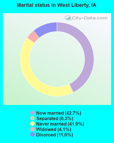
- Never married: 41.9%
- Now married: 42.7%
- Separated: 0.3%
- Widowed: 4.1%
- Divorced: 11.0%
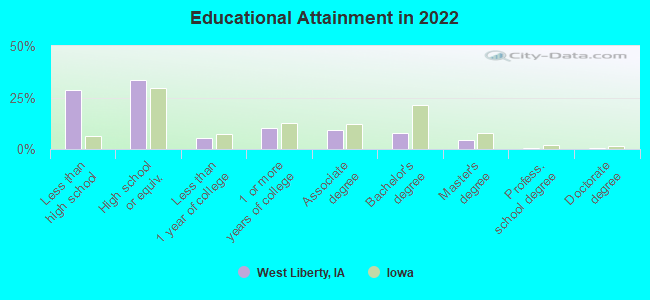
For population 25 years and over in West Liberty:
- High school or higher: 70.7%
- Bachelor's degree or higher: 12.0%
- Graduate or professional degree: 4.9%
- Unemployed: 3.9%
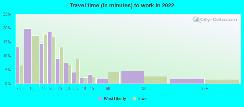
- Mean travel time to work (commute): 18.2 minutes
| Here: | 16.2 |
| Iowa average: | 10.5 |
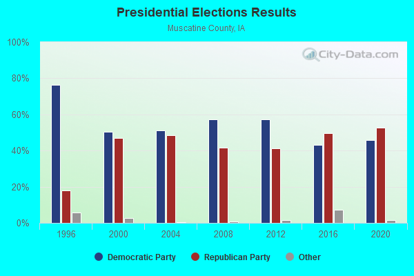
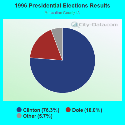
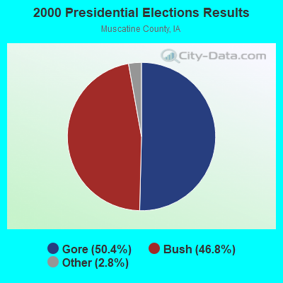


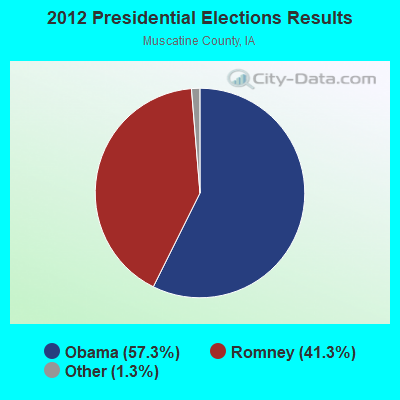


Graphs represent county-level data. Detailed 2008 Election Results
Religion statistics for West Liberty, IA (based on Muscatine County data)
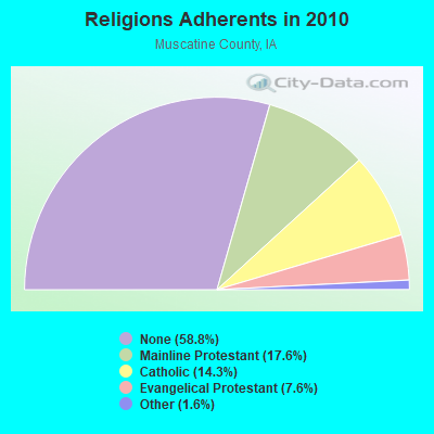
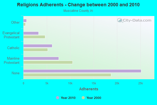
| Religion | Adherents | Congregations |
|---|---|---|
| Mainline Protestant | 7,542 | 30 |
| Catholic | 6,120 | 4 |
| Evangelical Protestant | 3,262 | 28 |
| Other | 679 | 3 |
| None | 25,142 | - |
Food Environment Statistics:
| Muscatine County: | 2.13 / 10,000 pop. |
| Iowa: | 2.14 / 10,000 pop. |
| This county: | 0.24 / 10,000 pop. |
| Iowa: | 0.23 / 10,000 pop. |
| This county: | 0.24 / 10,000 pop. |
| State: | 0.43 / 10,000 pop. |
| Muscatine County: | 4.96 / 10,000 pop. |
| Iowa: | 5.55 / 10,000 pop. |
| Muscatine County: | 8.03 / 10,000 pop. |
| Iowa: | 8.01 / 10,000 pop. |
| Muscatine County: | 7.1% |
| Iowa: | 7.8% |
| Muscatine County: | 27.9% |
| Iowa: | 27.3% |
| This county: | 19.0% |
| State: | 14.5% |
Health and Nutrition:
| Here: | 46.2% |
| Iowa: | 49.5% |
| Here: | 44.4% |
| Iowa: | 46.1% |
| This city: | 28.5 |
| Iowa: | 28.6 |
| West Liberty: | 21.4% |
| Iowa: | 21.4% |
| West Liberty: | 10.8% |
| Iowa: | 10.4% |
| West Liberty: | 6.8 |
| Iowa: | 6.8 |
| Here: | 31.6% |
| State: | 33.8% |
| West Liberty: | 54.6% |
| Iowa: | 55.9% |
| This city: | 79.3% |
| Iowa: | 77.7% |
More about Health and Nutrition of West Liberty, IA Residents
| Local government employment and payroll (March 2022) | |||||
| Function | Full-time employees | Monthly full-time payroll | Average yearly full-time wage | Part-time employees | Monthly part-time payroll |
|---|---|---|---|---|---|
| Police Protection - Officers | 8 | $37,590 | $56,385 | 1 | $830 |
| Solid Waste Management | 6 | $21,924 | $43,848 | 0 | $0 |
| Financial Administration | 4 | $21,585 | $64,755 | 0 | $0 |
| Local Libraries | 3 | $15,775 | $63,100 | 5 | $7,232 |
| Electric Power | 3 | $21,679 | $86,716 | 0 | $0 |
| Parks and Recreation | 2 | $9,903 | $59,418 | 1 | $6,639 |
| Sewerage | 2 | $10,656 | $63,936 | 0 | $0 |
| Water Supply | 2 | $12,344 | $74,064 | 0 | $0 |
| Other Government Administration | 1 | $10,016 | $120,192 | 9 | $1,827 |
| Police - Other | 1 | $4,615 | $55,380 | 0 | $0 |
| Totals for Government | 32 | $166,087 | $62,283 | 16 | $16,528 |
West Liberty government finances - Expenditure in 2021 (per resident):
- Construction - Regular Highways: $220,000 ($58.65)
Electric Utilities: $146,000 ($38.92)
General Public Buildings: $110,000 ($29.33)
- Current Operations - Electric Utilities: $4,505,000 ($1201.01)
Sewerage: $1,139,000 ($303.65)
Police Protection: $584,000 ($155.69)
Libraries: $548,000 ($146.09)
General - Other: $524,000 ($139.70)
Water Utilities: $497,000 ($132.50)
Parks and Recreation: $493,000 ($131.43)
Solid Waste Management: $385,000 ($102.64)
Health - Other: $257,000 ($68.52)
Miscellaneous Commercial Activities - Other: $150,000 ($39.99)
Regular Highways: $95,000 ($25.33)
Local Fire Protection: $82,000 ($21.86)
Protective Inspection and Regulation - Other: $44,000 ($11.73)
Judicial and Legal Services: $40,000 ($10.66)
Financial Administration: $26,000 ($6.93)
Central Staff Services: $14,000 ($3.73)
General Public Buildings: $5,000 ($1.33)
- Electric Utilities - Interest on Debt: $101,000 ($26.93)
- General - Interest on Debt: $195,000 ($51.99)
- Other Capital Outlay - Solid Waste Management: $43,000 ($11.46)
- Total Salaries and Wages: $2,011,000 ($536.12)
- Water Utilities - Interest on Debt: $36,000 ($9.60)
West Liberty government finances - Revenue in 2021 (per resident):
- Charges - Sewerage: $2,264,000 ($603.57)
Solid Waste Management: $519,000 ($138.36)
Other: $238,000 ($63.45)
Parks and Recreation: $18,000 ($4.80)
Miscellaneous Commercial Activities: $7,000 ($1.87)
- Federal Intergovernmental - Other: $67,000 ($17.86)
- Local Intergovernmental - Other: $38,000 ($10.13)
- Miscellaneous - General Revenue - Other: $145,000 ($38.66)
Interest Earnings: $113,000 ($30.13)
Fines and Forfeits: $10,000 ($2.67)
- Revenue - Electric Utilities: $5,023,000 ($1339.11)
Water Utilities: $845,000 ($225.27)
- State Intergovernmental - Highways: $563,000 ($150.09)
- Tax - Property: $1,677,000 ($447.08)
General Sales and Gross Receipts: $560,000 ($149.29)
Public Utilities Sales: $14,000 ($3.73)
Other License: $13,000 ($3.47)
West Liberty government finances - Debt in 2021 (per resident):
- Long Term Debt - Beginning Outstanding - Unspecified Public Purpose: $15,543,000 ($4143.70)
Outstanding Unspecified Public Purpose: $14,232,000 ($3794.19)
Retired Unspecified Public Purpose: $3,546,000 ($945.35)
Issue, Unspecified Public Purpose: $2,235,000 ($595.84)
West Liberty government finances - Cash and Securities in 2021 (per resident):
- Bond Funds - Cash and Securities: $1,695,000 ($451.88)
- Other Funds - Cash and Securities: $7,270,000 ($1938.15)
- Sinking Funds - Cash and Securities: $2,590,000 ($690.48)
Businesses in West Liberty, IA
- Chevrolet: 1
- Econo Lodge: 1
- Subway: 1
Strongest AM radio stations in West Liberty:
- KCJJ (1630 AM; 10 kW; IOWA CITY, IA; Owner: RIVER CITY RADIO, INC.)
- WSUI (910 AM; 5 kW; IOWA CITY, IA; Owner: THE UNIVERSITY OF IOWA)
- KXEL (1540 AM; 50 kW; WATERLOO, IA; Owner: KXEL BROADCASTING COMPANY, INC.)
- WMT (600 AM; 5 kW; CEDAR RAPIDS, IA; Owner: CITICASTERS LICENSES, L.P.)
- KXIC (800 AM; 1 kW; IOWA CITY, IA; Owner: CITICASTERS LICENSES, L.P.)
- WHO (1040 AM; 50 kW; DES MOINES, IA; Owner: CITICASTERS LICENSES, L.P.)
- KCRG (1600 AM; 5 kW; CEDAR RAPIDS, IA; Owner: CEDAR RAPIDS TELEVISION CO.)
- WSCR (670 AM; 50 kW; CHICAGO, IL; Owner: INFINITY BROADCASTING OPERATIONS, INC.)
- WGN (720 AM; 50 kW; CHICAGO, IL; Owner: WGN CONTINENTAL BROADCASTING CO.)
- WKBF (1270 AM; 5 kW; ROCK ISLAND, IL; Owner: MERCURY BROADCASTING COMPANY, INC.)
- WTMJ (620 AM; 50 kW; MILWAUKEE, WI; Owner: JOURNAL BROADCAST CORPORATION)
- WOC (1420 AM; 5 kW; DAVENPORT, IA; Owner: CITICASTERS LICENSES, L.P.)
- WBBM (780 AM; 50 kW; CHICAGO, IL; Owner: INFINITY BROADCASTING OPERATIONS, INC.)
Strongest FM radio stations in West Liberty:
- KSUI (91.7 FM; IOWA CITY, IA; Owner: THE UNIVERSITY OF IOWA)
- KBEA-FM (99.7 FM; MUSCATINE, IA; Owner: CUMULUS LICENSING CORP.)
- KWCC (93.1 FM; MUSCATINE, IA; Owner: WPW BROADCASTING, INC.)
- KKRQ (100.7 FM; IOWA CITY, IA; Owner: CITICASTERS LICENSES, L.P.)
- KRNA (94.1 FM; IOWA CITY, IA; Owner: CUMULUS LICENSING CORP.)
- WLLR-FM (103.7 FM; DAVENPORT, IA; Owner: CITICASTERS LICENSES, L.P.)
- WVIK (90.3 FM; ROCK ISLAND, IL; Owner: AUGUSTANA COLLEGE)
- KDAT (104.5 FM; CEDAR RAPIDS, IA; Owner: CUMULUS LICENSING CORP.)
- KCQQ (106.5 FM; DAVENPORT, IA; Owner: CITICASTERS LICENSES, L.P.)
- KZIA (102.9 FM; CEDAR RAPIDS, IA; Owner: KZIA, INC.)
- K295AC (106.9 FM; IOWA CITY, IA; Owner: KIRKWOOD COMMUNITY COLLEGE)
- KMXG (96.1 FM; CLINTON, IA; Owner: CITICASTERS LICENSES, L.P.)
TV broadcast stations around West Liberty:
- KIIN (Channel 12; IOWA CITY, IA; Owner: IOWA PUBLIC BROADCASTING BOARD)
- KWKB (Channel 20; IOWA CITY, IA; Owner: KM TELEVISION OF IOWA, L.L.C.)
- K16EL (Channel 66; DAVENPORT, IA; Owner: THREE ANGELS BROADCASTING NETWORK)
- KFXA (Channel 28; CEDAR RAPIDS, IA; Owner: SECOND GENERATION OF IOWA, LTD.)
- K62FU (Channel 62; MUSCATINE, IA; Owner: TRINITY BROADCASTING NETWORK)
- KGAN (Channel 2; CEDAR RAPIDS, IA; Owner: KGAN LICENSEE, LLC)
- KCRG-TV (Channel 9; CEDAR RAPIDS, IA; Owner: CEDAR RAPIDS TELEVISION CO.)
- WHBF-TV (Channel 4; ROCK ISLAND, IL; Owner: CORONET COMMUNICATIONS COMPANY)
- K64DG (Channel 64; IOWA CITY, IA; Owner: R B SHELDAHL)
- KWQC-TV (Channel 6; DAVENPORT, IA; Owner: YOUNG BROADCASTING OF DAVENPORT, INC.)
- KRIN (Channel 32; WATERLOO, IA; Owner: IOWA PUBLIC BROADCASTING BOARD)
- KYOU-TV (Channel 15; OTTUMWA, IA; Owner: WAITT BROADCASTING, INC.)
- KGWB-TV (Channel 26; BURLINGTON, IA; Owner: BURLINGTON TELEVISION ACQUISITION CORP.)
- WBQD-LP (Channel 26; DAVENPORT, IA; Owner: FOUR SEASONS PEORIA, LLC)
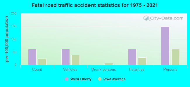
West Liberty fatal accident list:
Jan 2, 1985 10:09 AM, E 6th, Vehicles: 1, Persons: 2, Fatalities: 1
- National Bridge Inventory (NBI) Statistics
- 25Number of bridges
- 177ft / 54.5mTotal length
- 17,630Total average daily traffic
- 1,832Total average daily truck traffic
- 17,630Total future (year 2039) average daily traffic
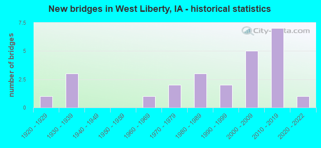
- New bridges - historical statistics
- 11920-1929
- 31930-1939
- 11960-1969
- 21970-1979
- 31980-1989
- 21990-1999
- 52000-2009
- 72010-2019
- 12020-2022
FCC Registered Antenna Towers: 15 (See the full list of FCC Registered Antenna Towers)
FCC Registered Broadcast Land Mobile Towers: 11 (See the full list of FCC Registered Broadcast Land Mobile Towers in West Liberty, IA)
FCC Registered Microwave Towers: 10 (See the full list of FCC Registered Microwave Towers in this town)
FCC Registered Amateur Radio Licenses: 10 (See the full list of FCC Registered Amateur Radio Licenses in West Liberty)
2003 - 2017 National Fire Incident Reporting System (NFIRS) incidents
- Fire incident types reported to NFIRS in West Liberty, IA
- 8746.0%Outside Fires
- 6735.4%Structure Fires
- 3015.9%Mobile Property/Vehicle Fires
- 52.6%Other
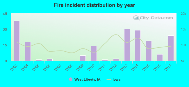 Based on the data from the years 2003 - 2017 the average number of fires per year is 13. The highest number of reported fires - 38 took place in 2003, and the least - 0 in 2007. The data has a dropping trend.
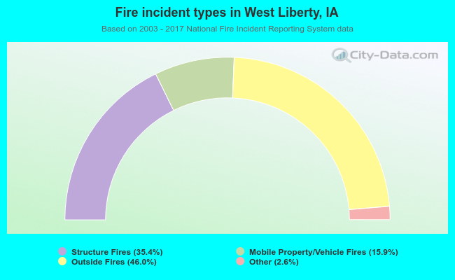 When looking into fire subcategories, the most reports belonged to: Outside Fires (46.0%), and Structure Fires (35.4%).
| Most common first names in West Liberty, IA among deceased individuals | ||
| Name | Count | Lived (average) |
|---|---|---|
| Robert | 23 | 78.7 years |
| John | 23 | 80.2 years |
| William | 21 | 78.4 years |
| Mary | 19 | 77.1 years |
| Harold | 17 | 75.7 years |
| Helen | 15 | 80.8 years |
| Margaret | 15 | 78.9 years |
| Donald | 14 | 75.4 years |
| George | 12 | 83.0 years |
| Clarence | 12 | 81.1 years |
| Most common last names in West Liberty, IA among deceased individuals | ||
| Last name | Count | Lived (average) |
|---|---|---|
| Smith | 23 | 79.7 years |
| Keith | 12 | 75.7 years |
| Wilson | 11 | 79.0 years |
| Wright | 9 | 75.2 years |
| Morrison | 9 | 78.1 years |
| Heath | 8 | 80.3 years |
| Johnson | 7 | 80.3 years |
| Phelps | 7 | 76.2 years |
| Jensen | 7 | 83.4 years |
| Walker | 7 | 81.3 years |
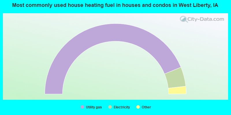
- 87.6%Utility gas
- 8.9%Electricity
- 2.5%Bottled, tank, or LP gas
- 1.0%Wood
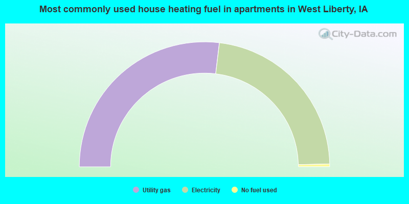
- 53.8%Utility gas
- 45.5%Electricity
- 0.7%No fuel used
West Liberty compared to Iowa state average:
- Unemployed percentage significantly below state average.
- Hispanic race population percentage significantly above state average.
- Median age significantly below state average.
- Foreign-born population percentage significantly above state average.
- Length of stay since moving in significantly above state average.
- Percentage of population with a bachelor's degree or higher below state average.

|
|
Total of 16 patent applications in 2008-2024.