West Woods, Oklahoma
Submit your own pictures of this place and show them to the world
- OSM Map
- General Map
- Google Map
- MSN Map

| Males: 217 | |
| Females: 246 |
| Median resident age: | 41.4 years |
| Oklahoma median age: | 35.5 years |
Zip code: 73842
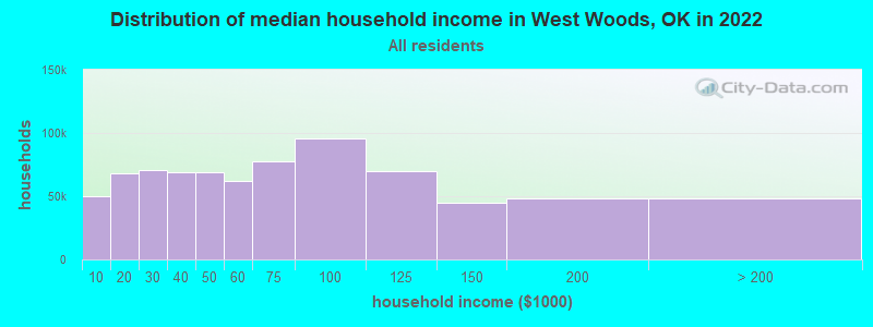
| West Woods: | $56,000 |
| OK: | $59,673 |
Estimated per capita income in 2022: $30,673 (it was $18,312 in 2000)
West Woods CCD income, earnings, and wages data
Estimated median house or condo value in 2022: $152,173 (it was $44,100 in 2000)
| West Woods: | $152,173 |
| OK: | $191,700 |
Detailed information about poverty and poor residents in West Woods, OK
Compare current foreclosures near West Woods, OK:
| Photo | Address | Area | Beds / Baths | Price | Details |
|---|---|---|---|---|---|

|
#1
State Highway 50
Freedom, OK 73842
|
- sq. feet
|
- baths - beds |
show details | |

|
Check over 1 million property listings on Foreclosure.com!
|
browse all offers | |||

- 46794.3%White alone
- 183.6%Hispanic
- 71.4%Two or more races
- 20.4%Asian alone
- 10.2%American Indian alone
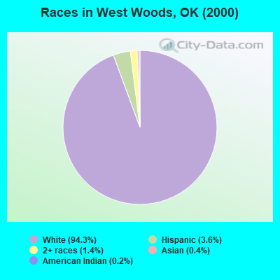
Races in West Woods detailed stats: ancestries, foreign born residents, place of birth
 Recent articles from our blog. Our writers, many of them Ph.D. graduates or candidates, create easy-to-read articles on a wide variety of topics.
Current Local Time: CST time zone
Land area: 345.1 square miles.
Population density: 1.3 people per square mile (very low).

| West Woods CCD: | 0.5% ($225) |
| Oklahoma: | 0.8% ($523) |
Nearest city with pop. 50,000+: Wichita, KS  (116.2 miles , pop. 344,284).
Nearest city with pop. 1,000,000+: Dallas, TX (309.9 miles , pop. 1,188,580).
Nearest cities:
), ), ), )Latitude: 36.84 N, Longitude: 99.16 W
Area code commonly used in this area: 580

| Here: | 1.6% |
| Oklahoma: | 3.2% |
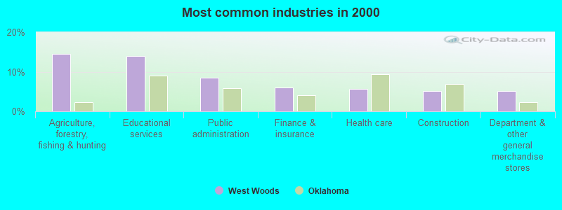
- Agriculture, forestry, fishing & hunting (14.5%)
- Educational services (14.0%)
- Public administration (8.4%)
- Finance & insurance (6.1%)
- Health care (5.6%)
- Construction (5.1%)
- Department & other general merchandise stores (5.1%)
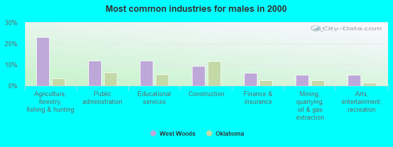
- Agriculture, forestry, fishing & hunting (23.1%)
- Public administration (12.0%)
- Educational services (12.0%)
- Construction (9.4%)
- Finance & insurance (6.0%)
- Mining, quarrying, oil & gas extraction (5.1%)
- Arts, entertainment, recreation (5.1%)
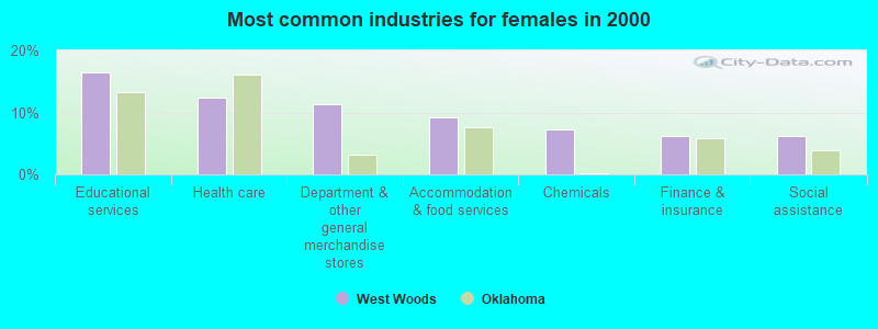
- Educational services (16.5%)
- Health care (12.4%)
- Department & other general merchandise stores (11.3%)
- Accommodation & food services (9.3%)
- Chemicals (7.2%)
- Finance & insurance (6.2%)
- Social assistance (6.2%)
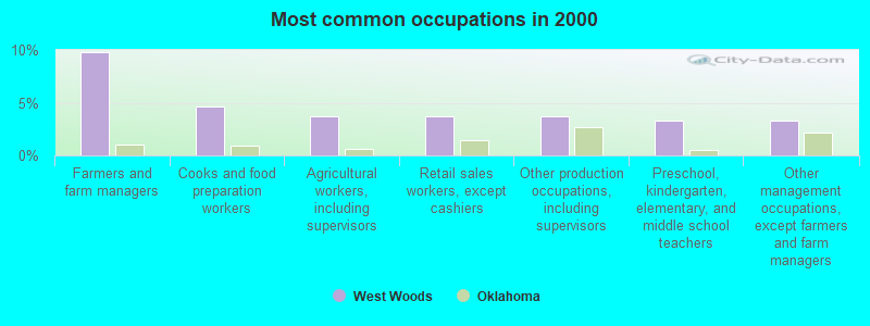
- Farmers and farm managers (9.8%)
- Cooks and food preparation workers (4.7%)
- Agricultural workers, including supervisors (3.7%)
- Retail sales workers, except cashiers (3.7%)
- Other production occupations, including supervisors (3.7%)
- Preschool, kindergarten, elementary, and middle school teachers (3.3%)
- Other management occupations, except farmers and farm managers (3.3%)
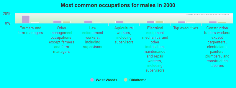
- Farmers and farm managers (16.2%)
- Other management occupations, except farmers and farm managers (6.0%)
- Law enforcement workers, including supervisors (6.0%)
- Agricultural workers, including supervisors (5.1%)
- Electrical equipment mechanics and other installation, maintenance, and repair workers, including supervisors (5.1%)
- Top executives (4.3%)
- Construction traders workers except carpenters, electricians, painters, plumbers, and construction laborers (4.3%)
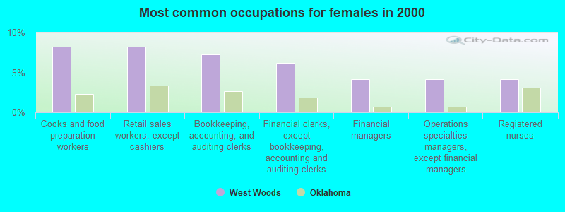
- Cooks and food preparation workers (8.2%)
- Retail sales workers, except cashiers (8.2%)
- Bookkeeping, accounting, and auditing clerks (7.2%)
- Financial clerks, except bookkeeping, accounting and auditing clerks (6.2%)
- Financial managers (4.1%)
- Operations specialties managers, except financial managers (4.1%)
- Registered nurses (4.1%)
Average climate in West Woods, Oklahoma
Based on data reported by over 4,000 weather stations


Tornado activity:
West Woods-area historical tornado activity is below Oklahoma state average. It is 66% greater than the overall U.S. average.
On 5/4/2007, a category F5 (max. wind speeds 261-318 mph) tornado 39.7 miles away from the West Woods place center killed 11 people and injured 63 people and caused $250 million in damages.
On 5/23/2008, a category F3 (max. wind speeds 158-206 mph) tornado 8.1 miles away from the place center .
Earthquake activity:
West Woods-area historical earthquake activity is significantly above Oklahoma state average. It is 840% greater than the overall U.S. average.On 9/3/2016 at 12:02:44, a magnitude 5.8 (5.8 MW, Depth: 3.5 mi, Class: Moderate, Intensity: VI - VII) earthquake occurred 126.8 miles away from the city center
On 11/6/2011 at 03:53:10, a magnitude 5.7 (5.7 MW, Depth: 3.2 mi) earthquake occurred 161.1 miles away from West Woods center
On 2/13/2016 at 17:07:06, a magnitude 5.1 (5.1 MW, Depth: 5.2 mi) earthquake occurred 34.5 miles away from West Woods center
On 1/7/2016 at 04:27:57, a magnitude 4.7 (4.7 MW, Depth: 2.5 mi, Class: Light, Intensity: IV - V) earthquake occurred 33.6 miles away from the city center
On 11/19/2015 at 07:42:12, a magnitude 4.7 (4.7 MW, Depth: 3.7 mi) earthquake occurred 40.5 miles away from the city center
On 11/12/2014 at 21:40:00, a magnitude 4.9 (4.9 MW, Depth: 2.5 mi) earthquake occurred 89.9 miles away from the city center
Magnitude types: moment magnitude (MW)
Natural disasters:
The number of natural disasters in Woods County (19) is greater than the US average (15).Major Disasters (Presidential) Declared: 10
Emergencies Declared: 6
Causes of natural disasters: Floods: 9, Winter Storms: 9, Storms: 5, Tornadoes: 5, Hurricane: 1, Ice Storm: 1, Snow: 1, Snowstorm: 1, Wind: 1, Other: 1 (Note: some incidents may be assigned to more than one category).
Colleges/universities with over 2000 students nearest to West Woods:
- Southwestern Oklahoma State University (about 94 miles; Weatherford, OK; Full-time enrollment: 4,126)
- Northern Oklahoma College (about 104 miles; Tonkawa, OK; FT enrollment: 3,414)
- Hutchinson Community College (about 109 miles; Hutchinson, KS; FT enrollment: 4,174)
- Barton County Community College (about 111 miles; Great Bend, KS; FT enrollment: 4,108)
- Wichita Technical Institute (about 114 miles; Wichita, KS; FT enrollment: 2,015)
- Newman University (about 114 miles; Wichita, KS; FT enrollment: 2,066)
- Friends University (about 115 miles; Wichita, KS; FT enrollment: 2,024)
Points of interest:
Notable locations in West Woods: Lookout (A), Lookout Community Hall (B), Camp Houston (C), Coy Community Hall (D), Freedom Volunteer Ambulance Service (E), Freedom Volunteer Fire Department (F). Display/hide their locations on the map
Church in West Woods: Lookout Church (A). Display/hide its location on the map
Cemeteries: Fairvalley Cemetery (1), Freedom Cemetery (2), Coy Cemetery (3), Lookout Cemetery (4), Mount Pleasant Cemetery (5), Preston Hill Cemetery (6), Cowboy Cemetery (7). Display/hide their locations on the map
Reservoirs: Burnham Number 4 Reservoir (A), Benson Number 3 Reservoir (B), Schroeder 1a Reservoir (C), Lenhart Reservoir (D), Burnham Number 9 Reservoir (E), Oknoname 151002 Reservoir (F). Display/hide their locations on the map
Creeks: Wildcat Creek (A), Day Creek (B), Bull Creek (C), Sand Creek (D), Redhorse Creek (E), Moccasin Creek (F), Doe Creek (G), Houston Creek (H). Display/hide their locations on the map
Park in West Woods: Rhodes Park (1). Display/hide its location on the map
| This place: | 2.2 people |
| Oklahoma: | 2.5 people |
| This place: | 66.3% |
| Whole state: | 66.8% |
| This place: | 4.8% |
| Whole state: | 5.9% |
No gay or lesbian households reported
| This place: | 11.5% |
| Whole state: | 14.7% |
| This place: | 3.8% |
| Whole state: | 6.1% |
For population 15 years and over in West Woods:
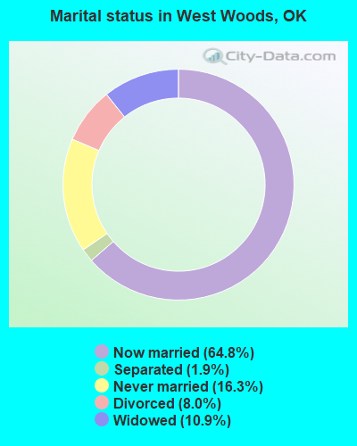
- Never married: 16.3%
- Now married: 64.8%
- Separated: 1.9%
- Widowed: 10.9%
- Divorced: 8.0%
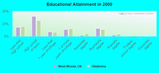
For population 25 years and over in West Woods:
- High school or higher: 82.0%
- Bachelor's degree or higher: 18.3%
- Graduate or professional degree: 2.7%
- Unemployed: 1.4%
- Mean travel time to work (commute): 20.1 minutes
| Here: | 9.3 |
| Oklahoma average: | 11.7 |
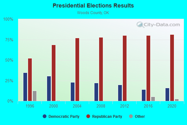
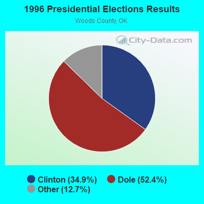
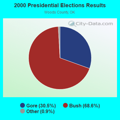
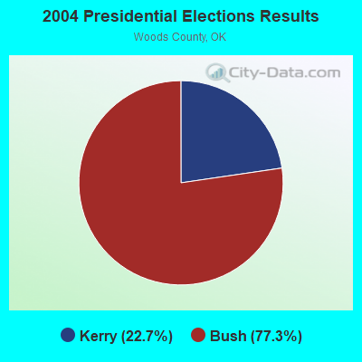
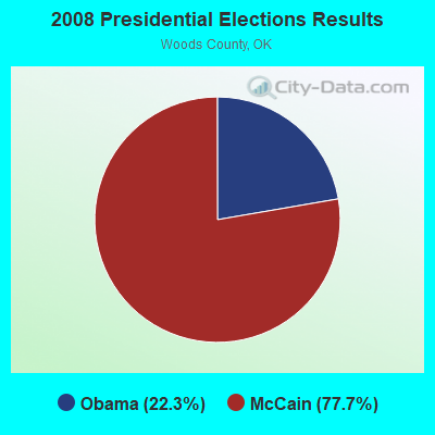
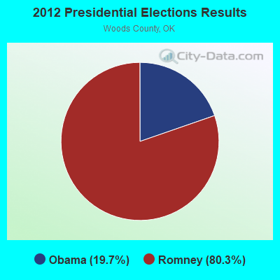
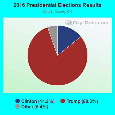
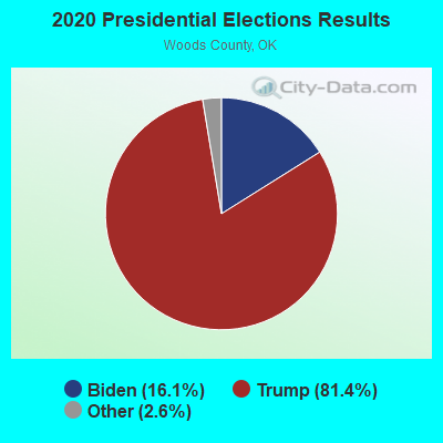
Graphs represent county-level data. Detailed 2008 Election Results
Religion statistics for West Woods, OK (based on Woods County data)
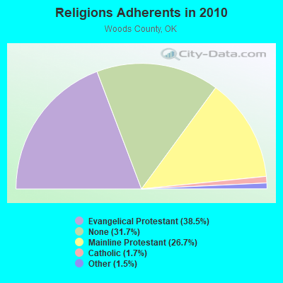
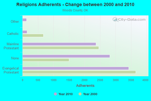
| Religion | Adherents | Congregations |
|---|---|---|
| Evangelical Protestant | 3,417 | 21 |
| Mainline Protestant | 2,368 | 9 |
| Catholic | 148 | 2 |
| Other | 130 | 2 |
| None | 2,815 | - |
Food Environment Statistics:
| This county: | 5.92 / 10,000 pop. |
| State: | 1.97 / 10,000 pop. |
| Woods County: | 1.18 / 10,000 pop. |
| Oklahoma: | 0.20 / 10,000 pop. |
| Here: | 1.18 / 10,000 pop. |
| Oklahoma: | 0.76 / 10,000 pop. |
| Woods County: | 7.10 / 10,000 pop. |
| Oklahoma: | 4.35 / 10,000 pop. |
| This county: | 7.10 / 10,000 pop. |
| State: | 6.89 / 10,000 pop. |
| Here: | 9.3% |
| Oklahoma: | 10.3% |
| Here: | 27.5% |
| State: | 29.2% |
Strongest AM radio stations in West Woods:
- KGYN (1210 AM; 50 kW; GUYMON, OK; Owner: TELNS BROADCASTING COMPANY, INC.)
- KRMG (740 AM; 50 kW; TULSA, OK; Owner: CXR HOLDINGS, INC.)
- KOMA (1520 AM; 50 kW; OKLAHOMA CITY, OK; Owner: RENDA BROADCASTING CORP. OF NEVADA)
- KCRC (1390 AM; 10 kW; ENID, OK; Owner: CHISHOLM TRAIL BROADCASTING CO.)
- KFAQ (1170 AM; 50 kW; TULSA, OK; Owner: JOURNAL BROADCAST CORPORATION)
- KWLS (1290 AM; 5 kW; PRATT, KS; Owner: WAITT RADIO, INC.)
- KRVN (880 AM; 50 kW; LEXINGTON, NE; Owner: NEBRASKA RURAL RADIO ASSOCIATION)
- KSIW (1450 AM; 1 kW; WOODWARD, OK; Owner: FUCHS COMMUNICATIONS, INC.)
- KFTI (1070 AM; 10 kW; WICHITA, KS; Owner: JOURNAL BROADCAST CORPORATION)
- WHB (810 AM; 50 kW; KANSAS CITY, MO; Owner: UNION BROADCASTING, INC.)
- KICA (980 AM; 50 kW; CLOVIS, NM; Owner: BROADCAST ENTERTAINMENT CORPORATION)
- WBAP (820 AM; 50 kW; FORT WORTH, TX; Owner: WBAP-KSCS OPERATING, LTD.)
- KGNO (1370 AM; 5 kW; DODGE CITY, KS; Owner: WAITT RADIO, INC.)
Strongest FM radio stations in West Woods:
- KWFX (93.5 FM; WOODWARD, OK; Owner: CLASSIC COMMUNICATIONS INC)
- KWOX (101.1 FM; WOODWARD, OK; Owner: OMNI COMMUNICATIONS, INC.)
- KMZE (92.1 FM; WOODWARD, OK; Owner: FM 92 BROADCASTERS, INC.)
- KWDQ (102.3 FM; WOODWARD, OK; Owner: CLASSIC COMMUNICATIONS, INC.)
TV broadcast stations around West Woods:
- KOMI-LP (Channel 24; WOODWARD, OK; Owner: 101 TELEVISION)
- K59EE (Channel 59; WOODWARD, ETC., OK; Owner: SHAFER TRANSLATOR, INC.)
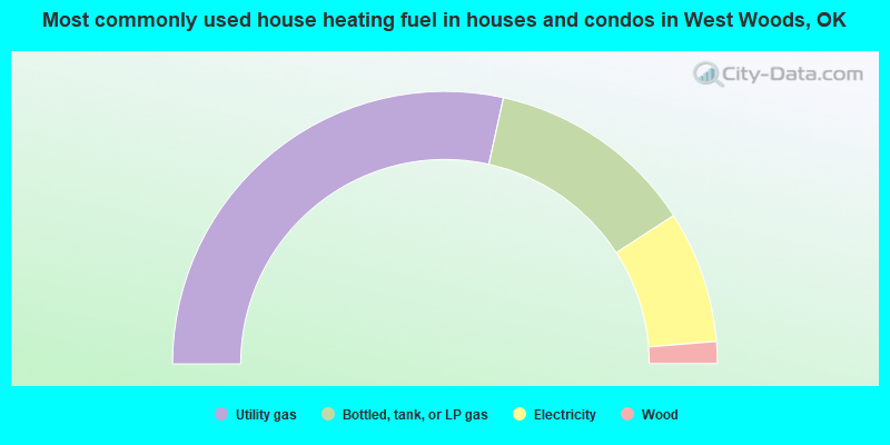
- 56.9%Utility gas
- 24.8%Bottled, tank, or LP gas
- 15.7%Electricity
- 2.6%Wood
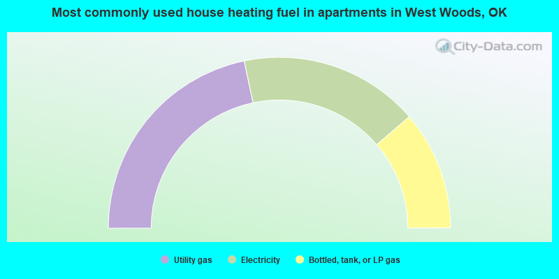
- 43.4%Utility gas
- 34.0%Electricity
- 22.6%Bottled, tank, or LP gas
West Woods compared to Oklahoma state average:
- Unemployed percentage significantly below state average.
- Black race population percentage significantly below state average.
- Hispanic race population percentage significantly below state average.
- Median age above state average.
- Foreign-born population percentage significantly below state average.
- Renting percentage below state average.
- Length of stay since moving in significantly above state average.
- Number of rooms per house significantly below state average.
- House age significantly below state average.