Western, Arizona
Submit your own pictures of this place and show them to the world
- OSM Map
- General Map
- Google Map
- MSN Map

| Males: 5,793 | |
| Females: 6,080 |
| Median resident age: | 23.4 years |
| Arizona median age: | 34.2 years |
Zip code: 86033
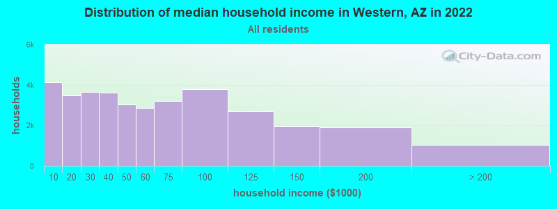
| Western: | $42,236 |
| AZ: | $74,568 |
Estimated per capita income in 2022: $17,431 (it was $8,232 in 2000)
Western CCD income, earnings, and wages data
Estimated median house or condo value in 2022: $77,565 (it was $25,000 in 2000)
| Western: | $77,565 |
| AZ: | $402,800 |
Mean prices in 2022: all housing units: $270,870; detached houses: $303,591; townhouses or other attached units: $455,253; in 3-to-4-unit structures: $254,269; in 5-or-more-unit structures: $298,694; mobile homes: $130,620; occupied boats, rvs, vans, etc.: $18,692
Detailed information about poverty and poor residents in Western, AZ
Compare current foreclosures near your location:
| Photo | Address | Area | Beds / Baths | Price | Details |
|---|---|---|---|---|---|

|
#1
S High St
Columbus, OH 43207
|
1,678 sq. feet
|
2 baths 4 beds |
$31,900
|
show details |

|
#2
Bayberry Cir
Columbus, OH 43207
|
1,564 sq. feet
|
1 baths 3 beds |
$127,500
|
show details |

|
#3
E 21st Ave
Columbus, OH 43211
|
1,061 sq. feet
|
1 baths 3 beds |
$187,900
|
show details |

|
#4
N Grener Ave
Columbus, OH 43228
|
1,120 sq. feet
|
1 baths 3 beds |
show details | |

|
#5
Ferris Rd
Columbus, OH 43224
|
2,218 sq. feet
|
3 baths 3 beds |
show details | |

|
#6
High Free Pike
West Jefferson, OH 43162
|
1,216 sq. feet
|
2 baths 4 beds |
show details | |

|
#7
Mink St SW
Pataskala, OH 43062
|
1,442 sq. feet
|
1 baths 3 beds |
show details | |

|
#8
Striebel Ct
Columbus, OH 43227
|
925 sq. feet
|
1 baths 3 beds |
show details | |

|
#9
Meadowbrook Dr
Columbus, OH 43207
|
1,752 sq. feet
|
2 baths 4 beds |
show details | |

|
#10
Falls Peak Ln
Delaware, OH 43015
|
1,352 sq. feet
|
2 baths 2 beds |
show details |
| Photo | Address | Area | Beds / Baths | Price | Details |
|---|---|---|---|---|---|

|
#11
S Hague Ave
Columbus, OH 43204
|
979 sq. feet
|
1 baths 2 beds |
show details | |

|
#12
E Welch Ave
Columbus, OH 43207
|
1,864 sq. feet
|
2 baths 4 beds |
show details | |

|
#13
Wrexham Ave
Columbus, OH 43223
|
1,235 sq. feet
|
1 baths 3 beds |
show details | |

|
#14
Bunch Flower Ct
Westerville, OH 43082
|
3,173 sq. feet
|
2 baths 4 beds |
show details | |

|
#15
Mayflower Blvd
Columbus, OH 43213
|
1,591 sq. feet
|
2 baths 4 beds |
show details | |

|
#16
Bretton Pl
Columbus, OH 43211
|
1,056 sq. feet
|
1 baths 3 beds |
show details | |

|
#17
Midland Ave
Columbus, OH 43223
|
1,518 sq. feet
|
1 baths 2 beds |
show details | |

|
#18
Derrer Rd -872
Columbus, OH 43204
|
1,667 sq. feet
|
2 baths 5 beds |
show details | |

|
#19
Kingsglen Dr
Grove City, OH 43123
|
1,635 sq. feet
|
2 baths 4 beds |
show details | |

|
#20
Trotter Dr
Columbus, OH 43207
|
1,478 sq. feet
|
1 baths 3 beds |
show details |
| Photo | Address | Area | Beds / Baths | Price | Details |
|---|---|---|---|---|---|

|
#21
S Richardson Ave
Columbus, OH 43204
|
1,520 sq. feet
|
2 baths 3 beds |
show details | |

|
#22
Fergus Rd
Grove City, OH 43123
|
3,312 sq. feet
|
2 baths 4 beds |
show details | |

|
#23
Stoneybrook Blvd # 21a
Hilliard, OH 43026
|
1,231 sq. feet
|
2 baths 3 beds |
show details | |

|
#24
Chester Rd
Columbus, OH 43221
|
3,300 sq. feet
|
4 baths 5 beds |
show details | |

|
#25
Hiawatha Park Dr
Columbus, OH 43211
|
1,278 sq. feet
|
1 baths 4 beds |
show details | |

|
#26
Edgeview Rd
Columbus, OH 43207
|
1,700 sq. feet
|
1 baths 4 beds |
show details | |

|
#27
Belle Oak Dr
Galloway, OH 43119
|
1,296 sq. feet
|
2 baths 3 beds |
show details | |

|
#28
Scottwood Rd
Columbus, OH 43227
|
1,008 sq. feet
|
1 baths 3 beds |
show details | |

|
#29
N Roys Ave
Columbus, OH 43204
|
1,248 sq. feet
|
2 baths 3 beds |
show details | |

|
#30
Elaine Rd
Columbus, OH 43213
|
764 sq. feet
|
1 baths 2 beds |
show details |
| Photo | Address | Area | Beds / Baths | Price | Details |
|---|---|---|---|---|---|

|
#31
Fahlander Dr N
Columbus, OH 43229
|
1,338 sq. feet
|
2 baths 3 beds |
show details | |

|
#32
Sleeping Meadow Dr
New Albany, OH 43054
|
3,211 sq. feet
|
2 baths 4 beds |
show details | |

|
#33
Bernadette Rd
Columbus, OH 43204
|
1,168 sq. feet
|
1 baths 3 beds |
show details | |

|
#34
Rosewood Ct
Powell, OH 43065
|
2,801 sq. feet
|
3 baths 4 beds |
show details | |

|
#35
Marshrun Dr
Grove City, OH 43123
|
2,036 sq. feet
|
2 baths 4 beds |
show details | |

|
#36
Brookstone Dr
Westerville, OH 43082
|
1,783 sq. feet
|
3 baths 3 beds |
show details | |

|
#37
Nantucket Ave
Columbus, OH 43235
|
1,864 sq. feet
|
2 baths 3 beds |
show details | |

|
#38
Wesson Dr
Columbus, OH 43232
|
1,200 sq. feet
|
1 baths 3 beds |
show details | |

|
#39
Bloomington Blvd
Columbus, OH 43228
|
1,940 sq. feet
|
2 baths 2 beds |
show details | |

|
#40
Falene Pl
Galloway, OH 43119
|
1,178 sq. feet
|
1 baths 3 beds |
show details |
| Photo | Address | Area | Beds / Baths | Price | Details |
|---|---|---|---|---|---|

|
#41
Tea Party Pl
Columbus, OH 43207
|
1,176 sq. feet
|
2 baths 3 beds |
show details | |

|
#42
Legionary St
Columbus, OH 43207
|
1,356 sq. feet
|
2 baths 3 beds |
show details | |

|
#43
Messner Dr
Hilliard, OH 43026
|
832 sq. feet
|
1 baths 2 beds |
show details | |

|
#44
Hackworth St
Columbus, OH 43207
|
1,163 sq. feet
|
2 baths 3 beds |
show details | |

|
#45
Lynn Cir
Grove City, OH 43123
|
936 sq. feet
|
1 baths 3 beds |
show details | |

|
#46
Mango Ln
Hilliard, OH 43026
|
1,024 sq. feet
|
1 baths 2 beds |
show details | |

|
#47
Legionary St
Columbus, OH 43207
|
1,200 sq. feet
|
1 baths 3 beds |
show details | |

|
#48
Casa Blvd
Grove City, OH 43123
|
1,002 sq. feet
|
1 baths 2 beds |
show details | |

|
#49
Saint James Ct
Columbus, OH 43220
|
1,314 sq. feet
|
1 baths 2 beds |
show details | |

|
Check over 1 million property listings on Foreclosure.com!
|
browse all offers | |||

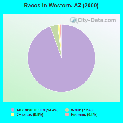
- 9,88294.4%American Indian alone
- 3803.6%White alone
- 970.9%Two or more races
- 930.9%Hispanic
- 100.10%Black alone
- 70.07%Asian alone
- 10.01%Native Hawaiian and Other
Pacific Islander alone
 Recent articles from our blog. Our writers, many of them Ph.D. graduates or candidates, create easy-to-read articles on a wide variety of topics.
Current Local Time: MST (no DST) time zone
Land area: 1639.9 square miles.
Population density: 7.2 people per square mile (very low).
| Western CCD: | 0.8% ($199) |
| Arizona: | 0.9% ($962) |
Nearest city with pop. 50,000+: Flagstaff, AZ  (126.6 miles , pop. 52,894).
Nearest city with pop. 200,000+: Scottsdale, AZ (231.9 miles , pop. 202,705).
Nearest city with pop. 1,000,000+: Phoenix, AZ (240.0 miles , pop. 1,321,045).
Nearest cities:
), ), ), )Latitude: 36.68 N, Longitude: 110.30 W
Area code commonly used in this area: 928

| Here: | 5.7% |
| Arizona: | 3.8% |
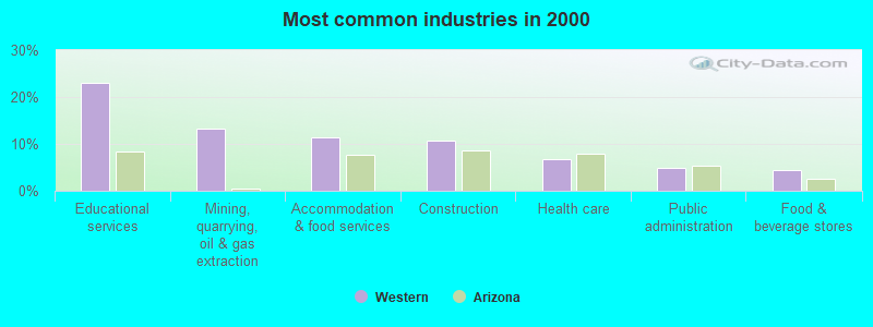
- Educational services (23.0%)
- Mining, quarrying, oil & gas extraction (13.2%)
- Accommodation & food services (11.3%)
- Construction (10.7%)
- Health care (6.7%)
- Public administration (4.9%)
- Food & beverage stores (4.4%)
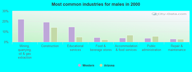
- Mining, quarrying, oil & gas extraction (22.0%)
- Construction (19.3%)
- Educational services (14.7%)
- Food & beverage stores (4.5%)
- Accommodation & food services (3.9%)
- Public administration (3.7%)
- Repair & maintenance (3.1%)
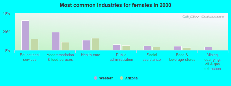
- Educational services (32.3%)
- Accommodation & food services (19.4%)
- Health care (10.8%)
- Public administration (6.2%)
- Social assistance (5.0%)
- Food & beverage stores (4.3%)
- Mining, quarrying, oil & gas extraction (3.5%)
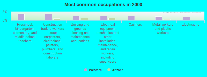
- Preschool, kindergarten, elementary, and middle school teachers (6.3%)
- Construction traders workers except carpenters, electricians, painters, plumbers, and construction laborers (5.9%)
- Building and grounds cleaning and maintenance occupations (4.4%)
- Electrical equipment mechanics and other installation, maintenance, and repair workers, including supervisors (4.1%)
- Cashiers (4.1%)
- Metal workers and plastic workers (3.7%)
- Electricians (3.4%)
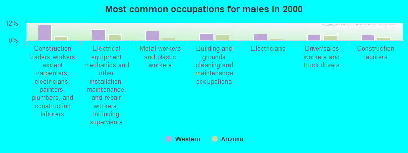
- Construction traders workers except carpenters, electricians, painters, plumbers, and construction laborers (10.8%)
- Electrical equipment mechanics and other installation, maintenance, and repair workers, including supervisors (7.8%)
- Metal workers and plastic workers (7.1%)
- Building and grounds cleaning and maintenance occupations (5.1%)
- Electricians (4.9%)
- Driver/sales workers and truck drivers (4.1%)
- Construction laborers (3.9%)
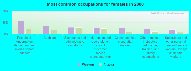
- Preschool, kindergarten, elementary, and middle school teachers (11.4%)
- Cashiers (6.7%)
- Secretaries and administrative assistants (5.8%)
- Information and record clerks, except customer service representatives (5.5%)
- Cooks and food preparation workers (5.1%)
- Other teachers, instructors, education, training, and library occupations (4.4%)
- Supervisors and other personal care and service workers, except child care workers (4.0%)
Average climate in Western, Arizona
Based on data reported by over 4,000 weather stations


Earthquake activity:
Western-area historical earthquake activity is significantly above Arizona state average. It is 2046% greater than the overall U.S. average.On 6/28/1992 at 11:57:34, a magnitude 7.6 (6.2 MB, 7.6 MS, 7.3 MW, Depth: 0.7 mi, Class: Major, Intensity: VIII - XII) earthquake occurred 391.1 miles away from the city center, causing 3 deaths (1 shaking deaths, 2 other deaths) and 400 injuries, causing $100,000,000 total damage and $40,000,000 insured losses
On 10/16/1999 at 09:46:44, a magnitude 7.4 (6.3 MB, 7.4 MS, 7.2 MW, 7.3 ML) earthquake occurred 375.9 miles away from Western center
On 5/19/1940 at 04:36:40, a magnitude 7.2 (7.2 UK) earthquake occurred 388.1 miles away from Western center, causing $33,000,000 total damage
On 10/3/1915 at 06:52:48, a magnitude 7.6 (7.6 UK) earthquake occurred 470.1 miles away from the city center
On 7/21/1952 at 11:52:14, a magnitude 7.7 (7.7 UK) earthquake occurred 501.2 miles away from the city center, causing $50,000,000 total damage
On 9/2/1992 at 10:26:20, a magnitude 5.9 (5.7 MB, 5.6 MS, 5.6 MW, 5.9 ML, Depth: 9.3 mi, Class: Moderate, Intensity: VI - VII) earthquake occurred 177.0 miles away from Western center
Magnitude types: body-wave magnitude (MB), local magnitude (ML), surface-wave magnitude (MS), moment magnitude (MW)
Natural disasters:
The number of natural disasters in Navajo County (19) is greater than the US average (15).Major Disasters (Presidential) Declared: 10
Emergencies Declared: 3
Causes of natural disasters: Floods: 8, Storms: 7, Fires: 6, Winter Storms: 2, Drought: 1, Flash Flood: 1, Heavy Rain: 1, Hurricane: 1, Tornado: 1, Other: 1 (Note: some incidents may be assigned to more than one category).
Colleges/universities with over 2000 students nearest to Western:
- San Juan College (about 119 miles; Farmington, NM; Full-time enrollment: 5,112)
- Northern Arizona University (about 129 miles; Flagstaff, AZ; FT enrollment: 22,494)
- Coconino Community College (about 129 miles; Flagstaff, AZ; FT enrollment: 2,090)
- Fort Lewis College (about 141 miles; Durango, CO; FT enrollment: 3,631)
- Southern Utah University (about 168 miles; Cedar City, UT; FT enrollment: 6,522)
- Northcentral University (about 183 miles; Prescott Valley, AZ; FT enrollment: 5,927)
- Dixie State University (about 183 miles; Saint George, UT; FT enrollment: 6,485)
Points of interest:
Notable locations in Western: Betatakin Ruin (A), White Rock Mesa Windmill (B), Calamity Cave Cliff Dwelling (C), Chilchinbito Trading Post (D), Navajo National Monument Campground (E), Long House Ruin (F), Navajo Tribal Utility (G), Cottonwood Windmill (H), Swallows Nest Ruins (I), Echo Cave Ruin (J), Tsegi Point Overlook (K), Tohdenasshai Trading Post (L), Tsegi Canyon Campground (M), Tsegi Trading Post (N), Kayenta Fire Department (O), Navajo National Monument Headquarters (P). Display/hide their locations on the map
Lake: Dry Lake (A). Display/hide its location on the map
Streams, rivers, and creeks: Cutfoot Wash (A), Parrish Creek (B), El Capitan Wash (C). Display/hide their locations on the map
Parks in Western include: Navajo National Monument (1), Wagon Wheel Rest Area (2), Monument Valley Navajo Tribal Park (3). Display/hide their locations on the map
| This place: | 3.8 people |
| Arizona: | 2.6 people |
| This place: | 61.3% |
| Whole state: | 68.2% |
| This place: | 6.8% |
| Whole state: | 6.2% |
Likely homosexual households (counted as self-reported same-sex unmarried-partner households)
- Lesbian couples: 0.5% of all households
- Gay men: 0.3% of all households
| This place: | 40.5% |
| Whole state: | 13.9% |
| This place: | 17.6% |
| Whole state: | 6.2% |
For population 15 years and over in Western:
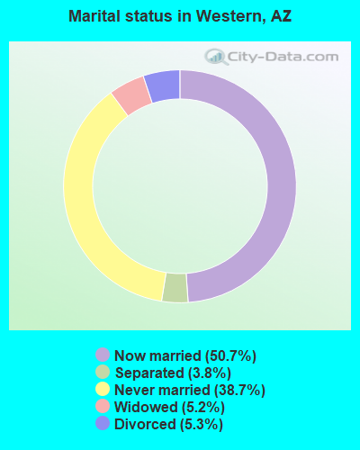
- Never married: 38.7%
- Now married: 50.7%
- Separated: 3.8%
- Widowed: 5.2%
- Divorced: 5.3%
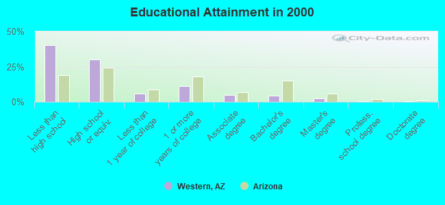
For population 25 years and over in Western:
- High school or higher: 59.6%
- Bachelor's degree or higher: 7.6%
- Graduate or professional degree: 3.1%
- Unemployed: 21.9%
- Mean travel time to work (commute): 31.2 minutes
| Here: | 25.3 |
| Arizona average: | 13.1 |
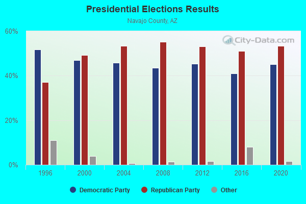
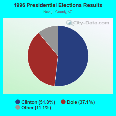
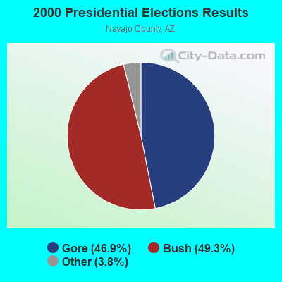
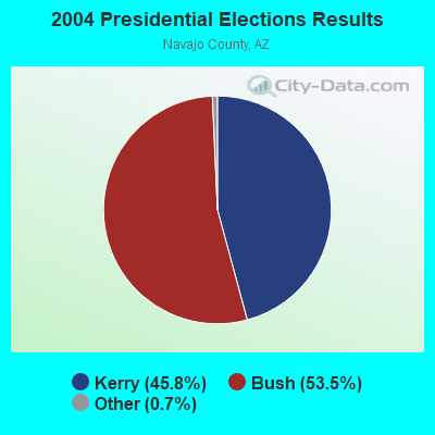
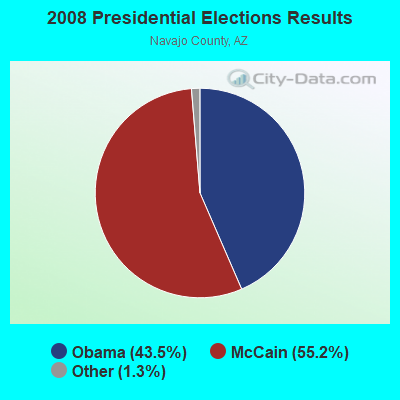
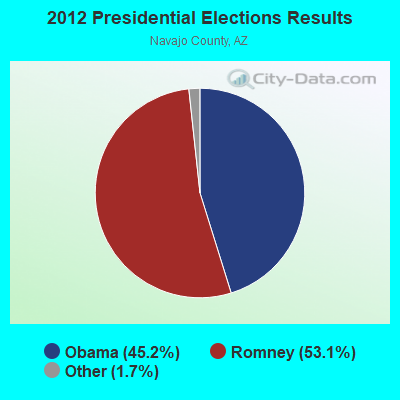
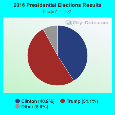
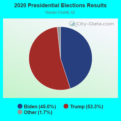
Graphs represent county-level data. Detailed 2008 Election Results
Religion statistics for Western, AZ (based on Navajo County data)

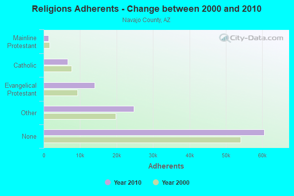
| Religion | Adherents | Congregations |
|---|---|---|
| Other | 24,727 | 62 |
| Evangelical Protestant | 13,966 | 98 |
| Catholic | 6,600 | 14 |
| Mainline Protestant | 1,410 | 18 |
| Black Protestant | 207 | 2 |
| None | 60,539 | - |
Food Environment Statistics:
| This county: | 1.71 / 10,000 pop. |
| State: | 1.36 / 10,000 pop. |
| This county: | 0.09 / 10,000 pop. |
| Arizona: | 0.14 / 10,000 pop. |
| Navajo County: | 0.27 / 10,000 pop. |
| State: | 0.55 / 10,000 pop. |
| Navajo County: | 4.95 / 10,000 pop. |
| Arizona: | 2.47 / 10,000 pop. |
| Navajo County: | 7.92 / 10,000 pop. |
| Arizona: | 6.21 / 10,000 pop. |
| Here: | 12.7% |
| State: | 8.0% |
| This county: | 26.1% |
| Arizona: | 22.8% |
| This county: | 9.8% |
| Arizona: | 14.2% |
Strongest AM radio stations in Western:
- KTNN (660 AM; 50 kW; WINDOW ROCK, AZ; Owner: THE NAVAJO NATION)
- KHAC (880 AM; 43 kW; TSE BONITO, NM; Owner: WESTERN INDIAN MINISTRIES, INC.)
- KMIA (710 AM; 50 kW; BLACK CANYON CITY, AZ; Owner: ENTRAVISION HOLDINGS, LLC)
- KNZZ (1100 AM; 50 kW; GRAND JUNCTION, CO; Owner: M B C GRAND BROADCASTING, INC.)
- KKOB (770 AM; 50 kW; ALBUQUERQUE, NM; Owner: CITADEL BROADCASTING COMPANY)
- KDWN (720 AM; 50 kW; LAS VEGAS, NV; Owner: RADIO NEVADA CORP.)
- KFNX (1100 AM; 50 kW; CAVE CREEK, AZ; Owner: NORTH AMERICAN BROADCASTING CO., INC.)
- KXNT (840 AM; 50 kW; NORTH LAS VEGAS, NV; Owner: INFINITY RADIO OPERATIONS INC.)
- KALL (700 AM; 50 kW; NORTH SALT LAKE CITY, UT; Owner: CITICASTERS LICENSES, L.P.)
- KFLT (830 AM; 50 kW; TUCSON, AZ; Owner: FAMILY LIFE B/CING SYSTEM, INC.)
- KPXQ (1360 AM; 50 kW; GLENDALE, AZ; Owner: COMMON GROUND BROADCASTING, INC.)
- KMIK (1580 AM; 50 kW; TEMPE, AZ; Owner: ABC, INC.)
- KIQN (1010 AM; 50 kW; TOOELE, UT)
Strongest FM radio stations in Western:
- KFXR-FM (107.3 FM; CHINLE, AZ; Owner: CLEAR CHANNEL BROADCASTING LICENSES, INC.)
TV broadcast stations around Western:
- K08HQ (Channel 8; CHINLE, AZ; Owner: KOB-TV, LLC)
- K38CX (Channel 38; SHONTO, AZ; Owner: TRINITY BROADCASTING NETWORK)
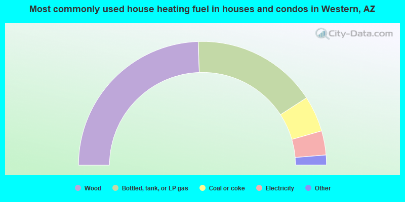
- 48.9%Wood
- 32.8%Bottled, tank, or LP gas
- 9.4%Coal or coke
- 6.3%Electricity
- 2.2%Utility gas
- 0.4%Other fuel
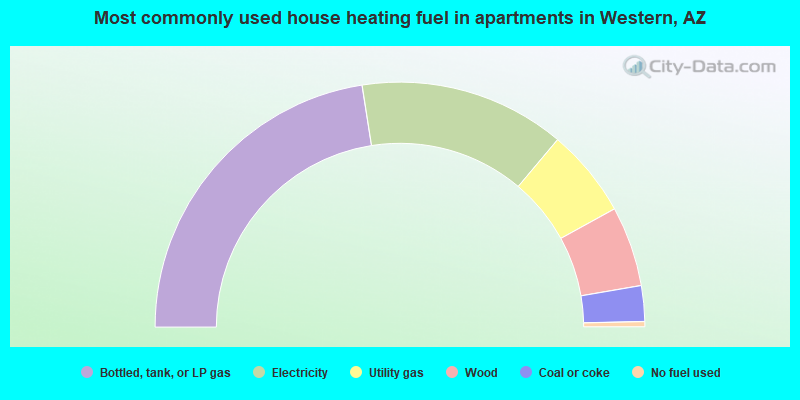
- 45.0%Bottled, tank, or LP gas
- 27.2%Electricity
- 11.7%Utility gas
- 10.6%Wood
- 4.7%Coal or coke
- 0.7%No fuel used
Western compared to Arizona state average:
- Median household income below state average.
- Median house value significantly below state average.
- Black race population percentage significantly below state average.
- Hispanic race population percentage significantly below state average.
- Median age significantly below state average.
- Foreign-born population percentage significantly below state average.
- Renting percentage significantly below state average.
- Length of stay since moving in significantly above state average.
- Number of rooms per house significantly below state average.
- House age significantly below state average.
- Percentage of population with a bachelor's degree or higher significantly below state average.
Western on our top lists:
- #1 on the list of "Top 101 cities with largest percentage of females in occupations: electricians (population 5,000+)"
- #2 on the list of "Top 101 cities with largest percentage of females in occupations: extraction workers (population 5,000+)"
- #3 on the list of "Top 101 cities with largest percentage of females in occupations: motor vehicle operators except bus and truck drivers (population 5,000+)"
- #3 on the list of "Top 101 cities with largest percentage of females in occupations: special education teachers (population 5,000+)"
- #4 on the list of "Top 101 cities with the largest house values disparities (population 5,000+)"
- #5 on the list of "Top 101 cities with largest percentage of males in occupations: electricians (population 5,000+)"
- #5 on the list of "Top 101 cities with largest percentage of males in occupations: construction trades workers except carpenters, electricians, painters, plumbers, and construction laborers (population 5,000+)"
- #11 on the list of "Top 100 cities with lowest ratio of median house value to median household income (pop. 5,000+)"
- #24 on the list of "Top 101 cities with the most people carpooling to work (population 5,000+)"
- #27 on the list of "Top 100 cities with largest land areas (pop. 5,000+)"
- #29 on the list of "Top 101 cities with largest percentage of females in industries: gasoline stations (population 5,000+)"
- #44 on the list of "Top 101 cities with largest percentage of males in industries: social assistance (population 5,000+)"
- #45 on the list of "Top 101 cities with largest percentage of males in industries: mining, quarrying, and oil and gas extraction (population 5,000+)"
- #48 on the list of "Top 101 cities with largest percentage of males in industries: gasoline stations (population 5,000+)"
- #52 on the list of "Top 101 cities with largest percentage of males in industries: water transportation (population 5,000+)"
- #59 on the list of "Top 101 cities with largest percentage of females in industries: mining, quarrying, and oil and gas extraction (population 5,000+)"
- #63 on the list of "Top 101 cities with largest percentage of males in industries: food and beverage stores (population 5,000+)"
- #69 on the list of "Top 101 cities with largest percentage of workers with very long commute times (90 or more minutes) (population 5,000+)"
- #69 on the list of "Top 101 cities with largest percentage of males in industries: petroleum and coal products (population 5,000+)"
- #75 on the list of "Top 101 cities with largest percentage of males in industries: fuel dealers (population 5,000+)"
- #3 (86033) on the list of "Top 101 zip codes with the largest percentage of Irish first ancestries (pop 5,000+)"
- #21 on the list of "Top 101 counties with the largest increase in the number of deaths per 1000 residents 2000-2006 to 2007-2013 (pop. 50,000+)"
- #23 on the list of "Top 101 counties with the highest Ozone (1-hour) air pollution readings in 2012 (ppm)"