Wirt, New York
Submit your own pictures of this town and show them to the world
- OSM Map
- General Map
- Google Map
- MSN Map
Population change since 2000: -8.6%
 |
| Males: 541 | |
| Females: 570 |
| Median resident age: | 40.9 years |
| New York median age: | 40.7 years |
Zip codes: 14739.
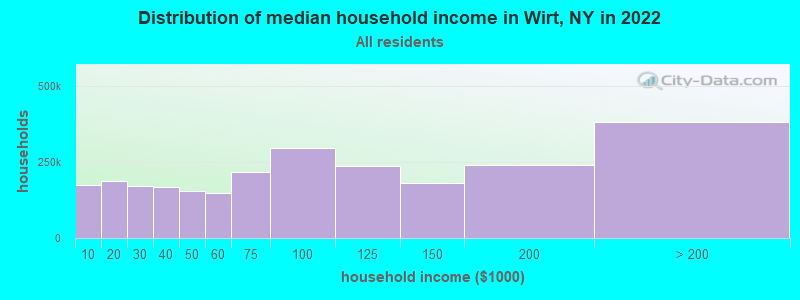
| Wirt: | $50,879 |
| NY: | $79,557 |
Estimated per capita income in 2022: $23,704 (it was $12,387 in 2000)
Wirt town income, earnings, and wages data
Estimated median house or condo value in 2022: $78,974 (it was $41,700 in 2000)
| Wirt: | $78,974 |
| NY: | $400,400 |
Mean prices in 2022: all housing units: $130,143; detached houses: $133,956; townhouses or other attached units: $933,393; in 2-unit structures: $134,751; in 3-to-4-unit structures: $363,909; in 5-or-more-unit structures: $254,137; mobile homes: $80,414; occupied boats, rvs, vans, etc.: $180,265
Detailed information about poverty and poor residents in Wirt, NY


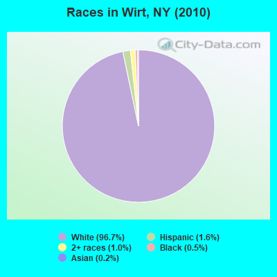
- 1,07496.7%White alone
- 181.6%Hispanic
- 111.0%Two or more races
- 50.5%Black alone
- 20.2%Asian alone
- 10.09%American Indian alone
Races in Wirt detailed stats: ancestries, foreign born residents, place of birth
 Recent articles from our blog. Our writers, many of them Ph.D. graduates or candidates, create easy-to-read articles on a wide variety of topics.


Latest news from Wirt, NY collected exclusively by city-data.com from local newspapers, TV, and radio stations
Ancestries: German (20.8%), English (19.5%), Irish (14.0%), United States (13.7%), Polish (4.0%), Dutch (3.2%).
Current Local Time: EST time zone
Elevation: 1893 feet
Land area: 35.9 square miles.
Population density: 31 people per square mile (very low).
4 residents are foreign born
| This town: | 0.3% |
| New York: | 20.4% |
| Wirt town: | 2.4% ($1,006) |
| New York: | 1.9% ($2,847) |
Nearest city with pop. 50,000+: Cheektowaga, NY  (63.4 miles , pop. 79,988).
Nearest city with pop. 200,000+: Buffalo, NY (65.4 miles , pop. 292,648).
Nearest city with pop. 1,000,000+: Philadelphia, PA (214.1 miles , pop. 1,517,550).
Nearest cities:
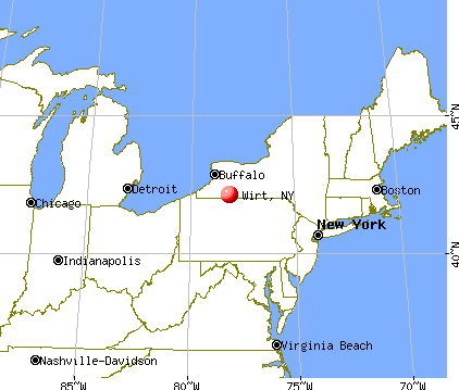
), ), ), ), )Latitude: 42.12 N, Longitude: 78.13 W
Area code commonly used in this area: 585

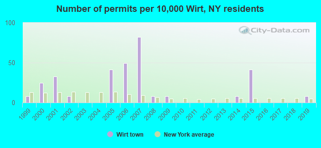
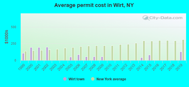
Single-family new house construction building permits:
- 2019: 1 building, cost: $130,000
- 2015: 5 buildings, average cost: $84,100
- 2014: 1 building, cost: $45,000
- 2009: 1 building, cost: $55,000
- 2008: 1 building, cost: $55,000
- 2007: 10 buildings, average cost: $54,900
- 2006: 6 buildings, average cost: $87,500
- 2005: 5 buildings, average cost: $52,200
- 2002: 1 building, cost: $200,000
- 2001: 4 buildings, average cost: $193,300
- 2000: 3 buildings, average cost: $193,300
- 1999: 1 building, cost: $109,200
| Here: | 4.9% |
| New York: | 4.4% |
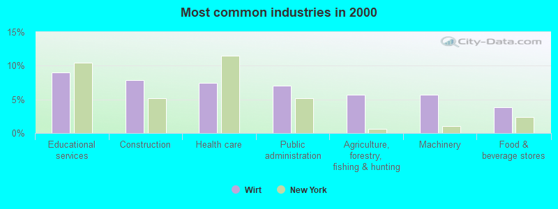
- Educational services (9.0%)
- Construction (7.8%)
- Health care (7.5%)
- Public administration (7.1%)
- Agriculture, forestry, fishing & hunting (5.7%)
- Machinery (5.7%)
- Food & beverage stores (3.8%)
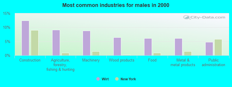
- Construction (12.5%)
- Agriculture, forestry, fishing & hunting (9.1%)
- Machinery (8.8%)
- Wood products (6.4%)
- Food (6.1%)
- Metal & metal products (6.1%)
- Public administration (4.7%)
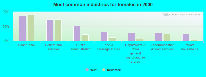
- Health care (17.3%)
- Educational services (14.6%)
- Public administration (10.2%)
- Food & beverage stores (6.2%)
- Department & other general merchandise stores (5.8%)
- Accommodation & food services (5.8%)
- Private households (4.9%)
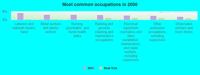
- Laborers and material movers, hand (6.9%)
- Metal workers and plastic workers (5.2%)
- Nursing, psychiatric, and home health aides (5.0%)
- Building and grounds cleaning and maintenance occupations (4.8%)
- Electrical equipment mechanics and other installation, maintenance, and repair workers, including supervisors (4.4%)
- Other production occupations, including supervisors (4.2%)
- Driver/sales workers and truck drivers (3.3%)
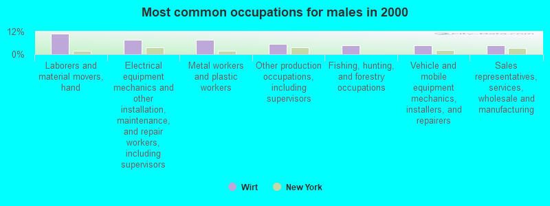
- Laborers and material movers, hand (10.8%)
- Electrical equipment mechanics and other installation, maintenance, and repair workers, including supervisors (7.7%)
- Metal workers and plastic workers (7.7%)
- Other production occupations, including supervisors (5.4%)
- Fishing, hunting, and forestry occupations (4.7%)
- Vehicle and mobile equipment mechanics, installers, and repairers (4.7%)
- Sales representatives, services, wholesale and manufacturing (4.7%)
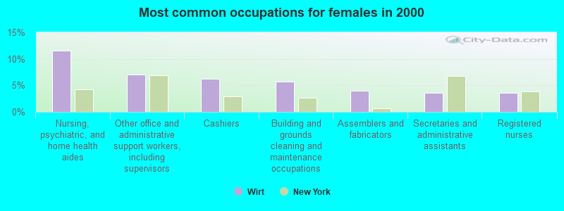
- Nursing, psychiatric, and home health aides (11.5%)
- Other office and administrative support workers, including supervisors (7.1%)
- Cashiers (6.2%)
- Building and grounds cleaning and maintenance occupations (5.8%)
- Assemblers and fabricators (4.0%)
- Secretaries and administrative assistants (3.5%)
- Registered nurses (3.5%)
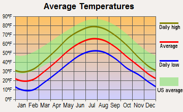
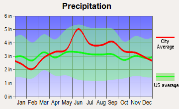
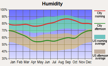
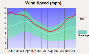
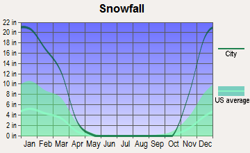
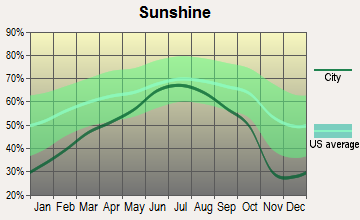
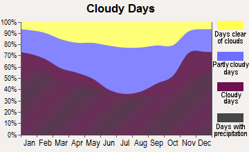
Average climate in Wirt, New York
Based on data reported by over 4,000 weather stations
Tornado activity:
Wirt-area historical tornado activity is slightly above New York state average. It is 58% smaller than the overall U.S. average.
On 6/20/1969, a category F3 (max. wind speeds 158-206 mph) tornado 14.5 miles away from the Wirt town center caused between $500,000 and $5,000,000 in damages.
On 7/21/2003, a category F3 tornado 17.4 miles away from the town center caused $200,000 in damages.
Earthquake activity:
Wirt-area historical earthquake activity is significantly above New York state average. It is 65% smaller than the overall U.S. average.On 9/25/1998 at 19:52:52, a magnitude 5.2 (4.8 MB, 4.3 MS, 5.2 LG, 4.5 MW, Depth: 3.1 mi, Class: Moderate, Intensity: VI - VII) earthquake occurred 124.5 miles away from the city center
On 8/23/2011 at 17:51:04, a magnitude 5.8 (5.8 MW, Depth: 3.7 mi) earthquake occurred 291.4 miles away from the city center
On 1/31/1986 at 16:46:43, a magnitude 5.0 (5.0 MB) earthquake occurred 159.9 miles away from Wirt center
On 10/7/1983 at 10:18:46, a magnitude 5.3 (5.1 MB, 5.3 LG, 5.1 ML) earthquake occurred 229.8 miles away from the city center
On 4/20/2002 at 10:50:47, a magnitude 5.3 (5.3 ML, Depth: 3.0 mi) earthquake occurred 277.8 miles away from the city center
On 4/20/2002 at 10:50:47, a magnitude 5.2 (5.2 MB, 4.2 MS, 5.2 MW, 5.0 MW) earthquake occurred 276.0 miles away from the city center
Magnitude types: regional Lg-wave magnitude (LG), body-wave magnitude (MB), local magnitude (ML), surface-wave magnitude (MS), moment magnitude (MW)
Natural disasters:
The number of natural disasters in Allegany County (21) is greater than the US average (15).Major Disasters (Presidential) Declared: 16
Emergencies Declared: 5
Causes of natural disasters: Storms: 14, Floods: 12, Hurricanes: 2, Tornadoes: 2, Blizzard: 1, Heavy Rain: 1, Landslide: 1, Power Outage: 1, Tropical Storm: 1, Wind: 1, Winter Storm: 1, Other: 2 (Note: some incidents may be assigned to more than one category).
Hospitals and medical centers near Wirt:
- WELLSVILLE MANOR NH (Nursing Home, about 9 miles away; WELLSVILLE, NY)
- HIGHLAND PARK REHABILITATION AND NURSING CENTER (Nursing Home, about 9 miles away; WELLSVILLE, NY)
- JONES MEMORIAL HOSPITAL Acute Care Hospitals (about 10 miles away; WELLSVILLE, NY)
- CUBA MEMORIAL HOSPITAL INC S N F (Nursing Home, about 11 miles away; CUBA, NY)
- HEWITT MANOR (Nursing Home, about 12 miles away; SHINGLEHOUSE, PA)
- ST FRANCIS HOSPITAL (Hospital, about 15 miles away; OLEAN, NY)
- ST JOSEPHS MANOR (Nursing Home, about 15 miles away; OLEAN, NY)
Colleges/universities with over 2000 students nearest to Wirt:
- St Bonaventure University (about 18 miles; Saint Bonaventure, NY; Full-time enrollment: 2,286)
- SUNY College of Technology at Alfred (about 21 miles; Alfred, NY; FT enrollment: 3,483)
- Alfred University (about 21 miles; Alfred, NY; FT enrollment: 2,411)
- SUNY College at Geneseo (about 50 miles; Geneseo, NY; FT enrollment: 5,520)
- Corning Community College (about 55 miles; Corning, NY; FT enrollment: 3,036)
- Jamestown Community College (about 56 miles; Jamestown, NY; FT enrollment: 3,384)
- Bryant & Stratton College-Online (about 57 miles; Orchard Park, NY; FT enrollment: 2,212)
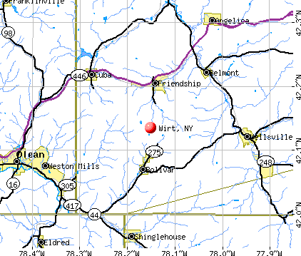
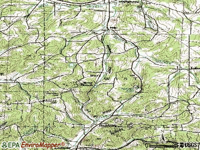
Points of interest:
Notable locations in Wirt: Val Dale Farms (A), Colonial Library (B), Richburg Volunteer Fire Company (C). Display/hide their locations on the map
Cemeteries: Wheeler Cemetery (1), Utopia Cemetery (2), Dimmick Cemetery (3). Display/hide their locations on the map
Lake: Paradise Lake (A). Display/hide its location on the map
| This town: | 2.5 people |
| New York: | 2.6 people |
| This town: | 70.2% |
| Whole state: | 63.5% |
| This town: | 9.3% |
| Whole state: | 6.8% |
No gay or lesbian households reported
| This town: | 14.8% |
| Whole state: | 14.6% |
| This town: | 6.9% |
| Whole state: | 7.4% |
For population 15 years and over in Wirt:
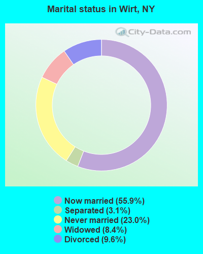
- Never married: 23.0%
- Now married: 55.9%
- Separated: 3.1%
- Widowed: 8.4%
- Divorced: 9.6%
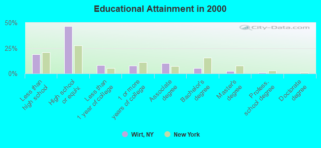
For population 25 years and over in Wirt:
- High school or higher: 80.9%
- Bachelor's degree or higher: 8.3%
- Graduate or professional degree: 3.2%
- Unemployed: 9.8%
- Mean travel time to work (commute): 30.6 minutes
| Here: | 8.7 |
| New York average: | 14.2 |
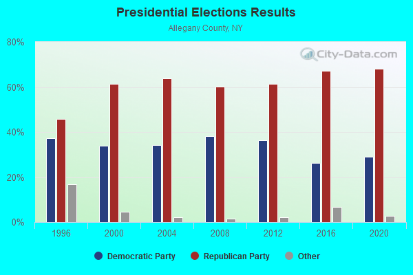
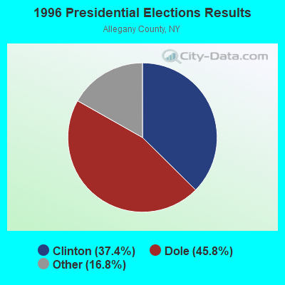
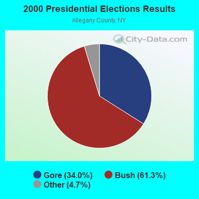

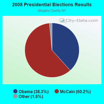
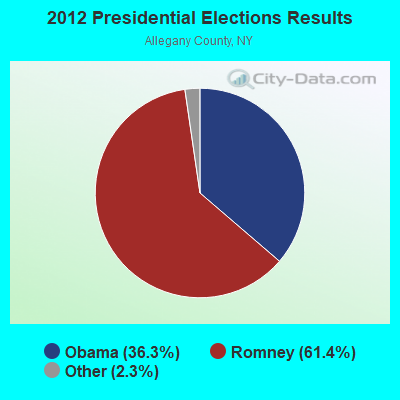
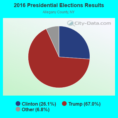
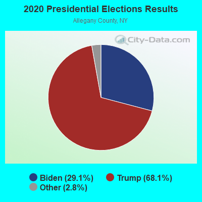
Graphs represent county-level data. Detailed 2008 Election Results
Religion statistics for Wirt, NY (based on Allegany County data)
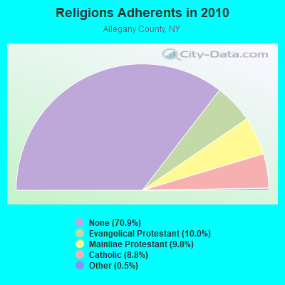
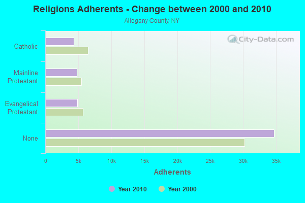
| Religion | Adherents | Congregations |
|---|---|---|
| Evangelical Protestant | 4,881 | 46 |
| Mainline Protestant | 4,798 | 39 |
| Catholic | 4,313 | 10 |
| Other | 244 | 4 |
| None | 34,710 | - |
Food Environment Statistics:
| This county: | 3.03 / 10,000 pop. |
| State: | 4.13 / 10,000 pop. |
| Here: | 0.40 / 10,000 pop. |
| New York: | 0.92 / 10,000 pop. |
| This county: | 5.25 / 10,000 pop. |
| New York: | 1.68 / 10,000 pop. |
| Allegany County: | 8.48 / 10,000 pop. |
| State: | 8.82 / 10,000 pop. |
| Allegany County: | 8.8% |
| New York: | 8.2% |
| Here: | 25.6% |
| New York: | 23.8% |
| Allegany County: | 11.5% |
| State: | 15.6% |
Strongest AM radio stations in Wirt:
- WLSV (790 AM; 1 kW; WELLSVILLE, NY; Owner: DBM COMMUNICATIONS, INC.)
- WWKB (1520 AM; 50 kW; BUFFALO, NY; Owner: ENTERCOM BUFFALO LICENSE, LLC)
- WHAM (1180 AM; 50 kW; ROCHESTER, NY; Owner: CITICASTERS LICENSES, L.P.)
- WHHO (1320 AM; 5 kW; HORNELL, NY; Owner: BILBAT RADIO, INC.)
- WOEN (1360 AM; 1 kW; OLEAN, NY; Owner: VOX ALLEGANY, LLC)
- WGGO (1590 AM; 5 kW; SALAMANCA, NY; Owner: CATT COMMUNICATIONS, INC.)
- WABH (1380 AM; 10 kW; BATH, NY)
- WGR (550 AM; 5 kW; BUFFALO, NY; Owner: ENTERCOM BUFFALO LICENSE, LLC)
- KDKA (1020 AM; 50 kW; PITTSBURGH, PA; Owner: INFINITY BROADCASTING OPERATIONS, INC.)
- WLEA (1480 AM; 2 kW; HORNELL, NY; Owner: PMJ COMMUNICATIONS, INC.)
- WFRM (600 AM; 1 kW; COUDERSPORT, PA; Owner: FARM & HOME BROADCASTING CO.)
- WHDL (1450 AM; 1 kW; OLEAN, NY; Owner: ARROW COMMUNICATIONS OF N.Y., INC.)
- WWJZ (640 AM; 50 kW; MOUNT HOLLY, NJ; Owner: ABC, INC.)
Strongest FM radio stations in Wirt:
- WCID (89.1 FM; FRIENDSHIP, NY; Owner: FAMILY LIFE MINISTRIES, INC.)
- WJQZ (103.5 FM; WELLSVILLE, NY; Owner: DBM COMMUNICATIONS, INC.)
- WZKZ (101.9 FM; ALFRED, NY; Owner: PEMBROOK PINES ELMIRA, LTD.)
- WPIG (95.7 FM; OLEAN, NY; Owner: ARROW COMMUNICATIONS OF N.Y., INC.)
- WOLN (91.3 FM; OLEAN, NY; Owner: STATE UNIVERSITY OF NEW YORK)
- WMXO (101.5 FM; OLEAN, NY; Owner: VOX ALLEGANY, LLC)
- WHKS (94.9 FM; PORT ALLEGANY, PA; Owner: L-COM INC.)
- W213BC (90.5 FM; OLEAN, NY; Owner: FAMILY LIFE MINISTRIES, INC.)
- WQRM (106.3 FM; SMETHPORT, PA; Owner: FARM & HOME BROADCASTING COMPANY)
- WQRT (98.3 FM; SALAMANCA, NY; Owner: CATT COMMUNICATIONS, INC.)
- WFRM-FM (96.7 FM; COUDERSPORT, PA; Owner: FARM & HOME BROADCASTING COMPANY)
- WTSS (102.5 FM; BUFFALO, NY; Owner: ENTERCOM BUFFALO LICENSE, LLC)
- WNSA (107.7 FM; WETHERSFIELD TWNSHP, NY; Owner: ADELPHIA COMMUNICATIONS CORPORATION, DEBTOR-IN-POSSESSION)
- WKPQ (105.3 FM; HORNELL, NY; Owner: BILBAT RADIO, INC.)
- WDNY-FM (93.9 FM; DANSVILLE, NY; Owner: MILLER MEDIA INC.)
- WSQA (88.7 FM; HORNELL, NY; Owner: WSKG PUBLIC TELECOMMUNICATIONS COUNCIL)
- WETD (90.7 FM; ALFRED, NY; Owner: STATE UNIVERSITY OF NEW YORK)
- WBRR (100.1 FM; BRADFORD, PA; Owner: RADIO STATION WESB, INC.)
- WCKR (92.1 FM; HORNELL, NY; Owner: PMJ COMMUNICATIONS, INC.)
- WJSL (90.3 FM; HOUGHTON, NY; Owner: WXXI PUBLIC BROADCASTING COUNCIL)
TV broadcast stations around Wirt:
- WNGS (Channel 67; SPRINGVILLE, NY; Owner: CAROLINE K. POWLEY D/B/A UNICORN/SPRINGVILLE)
- WKBW-TV (Channel 7; BUFFALO, NY; Owner: WKBW-TV LICENSE, INC.)
- WIVB-TV (Channel 4; BUFFALO, NY; Owner: WIVB BROADCASTING, LLC)
- W68AJ (Channel 68; BOLIVAR & RICHBURG, NY; Owner: WESTERN NEW YORK PUBLIC B/CING.ASSN.)
- W30BW (Channel 30; OLEAN, NY; Owner: TRINITY BROADCASTING NETWORK)
- W59AH (Channel 59; ALLENTOWN, ETC., NY; Owner: WESTERN NEW YORK PUBLIC B/CING.ASSN.)
- WONS-LP (Channel 25; OLEAN, NY; Owner: CHOICE OLEAN TELEVISION STATION, INC.)
- W62AS (Channel 62; FRIENDSHIP & BELMONT, NY; Owner: WESTERN NEW YORK PUBLIC B/CING.ASSN.)
- National Bridge Inventory (NBI) Statistics
- 6Number of bridges
- 23ft / 6.8mTotal length
- $5,191,000Total costs
- 5,113Total average daily traffic
- 477Total average daily truck traffic
- 5,345Total future (year 2036) average daily traffic
FCC Registered Antenna Towers:
2- Richard M Snavely, Pine Grove Rd 13.73 Km S Of Friendship (Lat: 42.118611 Lon: -78.178333), Type: 43.0, Structure height: 36003 m, Overall height: 43 m
- Pine Grove Rd 13.73 Km S Of Friendship (Lat: 42.118611 Lon: -78.178333), Type: 43.0, Overall height: 43 m, Registrant: Family Life Ministries Radio Inc Dba , Famlife@aol.Com, , 506 Bath, Phone: (607) 776-4151
FCC Registered Broadcast Land Mobile Towers:
2- NUNDA, Corner Of Burdik Road And Pinegrove Road (Lat: 42.132667 Lon: -78.177722), Type: Upole, Structure height: 9 m, Overall height: 11.5 m, Call Sign: WQGZ339,
Assigned Frequencies: 173.262 MHz, 173.287 MHz, Grant Date: 05/31/2007, Expiration Date: 05/31/2017, Cancellation Date: 10/22/2014, Certifier: Alan Mc Mcmullen, Registrant: Utilities Telecom Council, Inc., 1129 20th Street, Nw Suite 350, Washington, DC 20036, Phone: (203) 833-6818, Email:
- CLARKSVILLE, Burdick Road 1/2 Mile North Of Intersection Of Harland Ames Rd (Lat: 42.126111 Lon: -78.167611), Type: Upole, Structure height: 20 m, Overall height: 22 m, Call Sign: WQIF497,
Assigned Frequencies: 37.6200 MHz, Grant Date: 12/15/2017, Expiration Date: 01/24/2028, Certifier: Alan Mcmullen, Registrant: Utilities Telecom Council, Inc., 1129 20th Street, Nw Suite 350, Washington, DC 20036, Phone: (202) 833-6818, Email:
FCC Registered Microwave Towers:
1- Burdick, Lat: 42.126639 Lon: -78.167778, Type: Pole, Structure height: 21.2 m, Overall height: 23.6 m, Call Sign: WQSG754,
Assigned Frequencies: 3650.00 MHz, Grant Date: 09/18/2013, Expiration Date: 09/18/2023, Cancellation Date: 10/19/2022, Certifier: Scott Mahoney, Registrant: Lerman Senter Pllc, 2001 L Street, Nw, Suite 400, Washington, DC 20036, Phone: (202) 416-6749, Fax: (202) 293-7783, Email:
- 51.2%Utility gas
- 16.2%Wood
- 15.6%Fuel oil, kerosene, etc.
- 8.2%Bottled, tank, or LP gas
- 4.8%Electricity
- 2.7%Other fuel
- 1.3%Coal or coke
- 75.7%Utility gas
- 10.8%Fuel oil, kerosene, etc.
- 5.4%Electricity
- 5.4%Wood
- 2.7%Bottled, tank, or LP gas
Wirt compared to New York state average:
- Median household income below state average.
- Median house value significantly below state average.
- Black race population percentage significantly below state average.
- Hispanic race population percentage significantly below state average.
- Foreign-born population percentage significantly below state average.
- Renting percentage significantly below state average.
- Length of stay since moving in significantly above state average.
- Number of rooms per house significantly below state average.
- House age significantly below state average.
- Percentage of population with a bachelor's degree or higher significantly below state average.