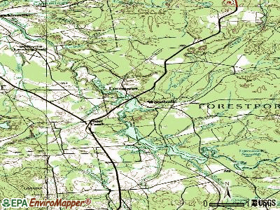
Woodhull, New York
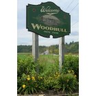
Woodhull: Sign for the Town of Woodhull, New York on State Route 417
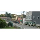
Woodhull: The bridge entering the town from State Route 417
- add
your
Submit your own pictures of this town and show them to the world
- OSM Map
- General Map
- Google Map
- MSN Map
Population change since 2000: +12.8%
 |
| Males: 865 | |
| Females: 854 |
| Median resident age: | 37.4 years |
| New York median age: | 40.7 years |
Zip codes: 14898.
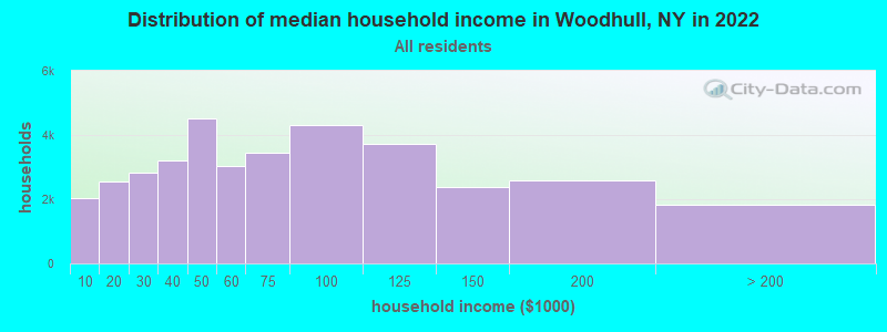
| Woodhull: | $54,353 |
| NY: | $79,557 |
Estimated per capita income in 2022: $26,026 (it was $13,674 in 2000)
Woodhull town income, earnings, and wages data
Estimated median house or condo value in 2022: $105,613 (it was $53,700 in 2000)
| Woodhull: | $105,613 |
| NY: | $400,400 |
Mean prices in 2022: all housing units: $169,714; detached houses: $184,786; townhouses or other attached units: $138,888; in 2-unit structures: $291,252; in 3-to-4-unit structures: $333,918; in 5-or-more-unit structures: $308,305; mobile homes: $80,148; occupied boats, rvs, vans, etc.: $43,655
Detailed information about poverty and poor residents in Woodhull, NY


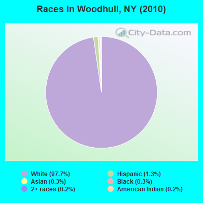
- 1,67997.7%White alone
- 221.3%Hispanic
- 50.3%Black alone
- 60.3%Asian alone
- 30.2%American Indian alone
- 40.2%Two or more races
Races in Woodhull detailed stats: ancestries, foreign born residents, place of birth
According to our research of New York and other state lists, there were 5 registered sex offenders living in Woodhull, New York as of April 29, 2024.
The ratio of all residents to sex offenders in Woodhull is 344 to 1.
 Recent articles from our blog. Our writers, many of them Ph.D. graduates or candidates, create easy-to-read articles on a wide variety of topics.

 | First time visiting the Adirondacks? What to experience in this famous New York state park (171 replies) |
| Woodhull road in Huntington a safe area ? (9 replies) |
| As Omicron Surges, NYC To Issue 1 Million Masks And 500k At-Home Tests (78 replies) |
| Serial Slasher Nabbed (11 replies) |
| Woodhull Residents housing connect (1 reply) |
| Shootout at Peter Luger (57 replies) |
Latest news from Woodhull, NY collected exclusively by city-data.com from local newspapers, TV, and radio stations
Ancestries: United States (14.6%), German (12.4%), English (12.1%), Irish (8.2%), Dutch (6.5%), French (3.1%).
Current Local Time: EST time zone
Land area: 55.4 square miles.
Population density: 31 people per square mile (very low).
11 residents are foreign born
| This town: | 0.7% |
| New York: | 20.4% |
| Woodhull town: | 1.1% ($565) |
| New York: | 1.9% ($2,847) |
Nearest city with pop. 50,000+: Union, NY (70.3 miles  , pop. 56,298).
Nearest city with pop. 200,000+: Rochester, NY (77.0 miles , pop. 219,773).
Nearest city with pop. 1,000,000+: Philadelphia, PA (184.7 miles , pop. 1,517,550).
Nearest cities:
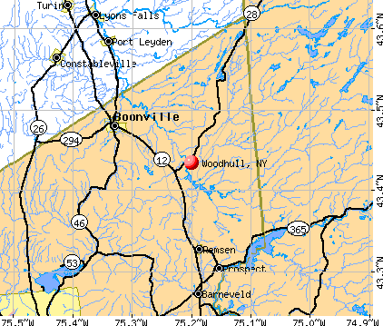
), )Latitude: 42.06 N, Longitude: 77.39 W
Area code: 607

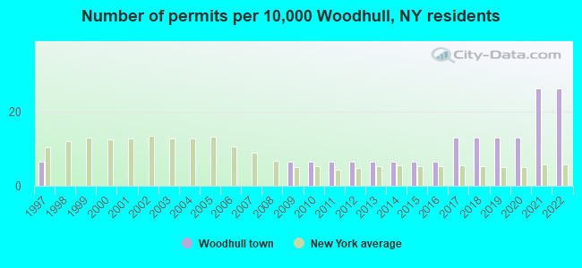
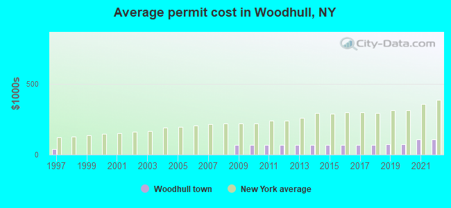
Single-family new house construction building permits:
- 2022: 4 buildings, average cost: $106,300
- 2021: 4 buildings, average cost: $106,300
- 2020: 2 buildings, average cost: $75,000
- 2019: 2 buildings, average cost: $75,000
- 2018: 2 buildings, average cost: $67,000
- 2017: 2 buildings, average cost: $67,000
- 2016: 1 building, cost: $67,000
- 2015: 1 building, cost: $67,000
- 2014: 1 building, cost: $67,000
- 2013: 1 building, cost: $67,000
- 2012: 1 building, cost: $67,000
- 2011: 1 building, cost: $67,000
- 2010: 1 building, cost: $67,000
- 2009: 1 building, cost: $67,000
- 1997: 1 building, cost: $40,000
| Here: | 4.5% |
| New York: | 4.4% |
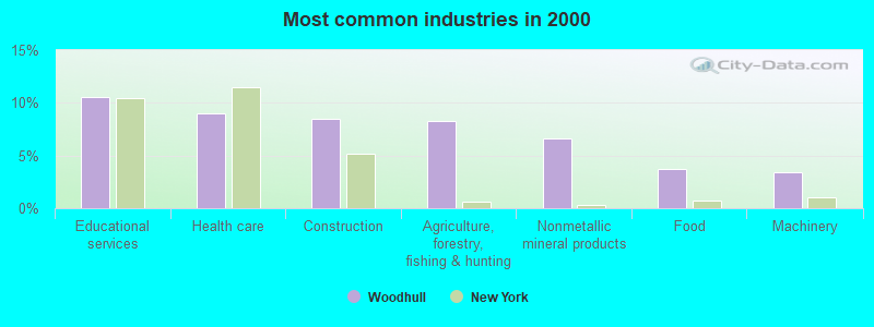
- Educational services (10.6%)
- Health care (9.0%)
- Construction (8.4%)
- Agriculture, forestry, fishing & hunting (8.3%)
- Nonmetallic mineral products (6.6%)
- Food (3.7%)
- Machinery (3.4%)
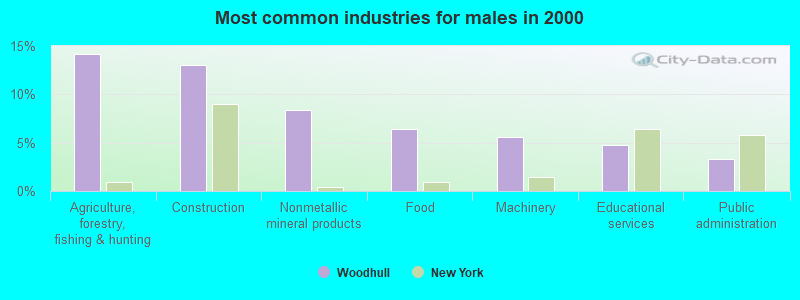
- Agriculture, forestry, fishing & hunting (14.2%)
- Construction (13.1%)
- Nonmetallic mineral products (8.3%)
- Food (6.4%)
- Machinery (5.6%)
- Educational services (4.7%)
- Public administration (3.3%)
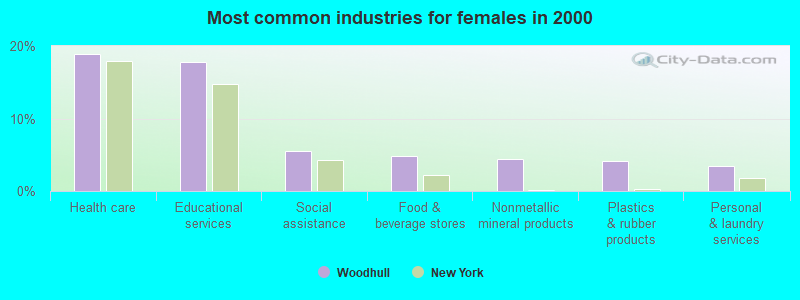
- Health care (18.8%)
- Educational services (17.8%)
- Social assistance (5.5%)
- Food & beverage stores (4.8%)
- Nonmetallic mineral products (4.5%)
- Plastics & rubber products (4.1%)
- Personal & laundry services (3.4%)
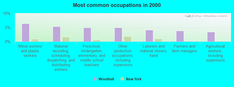
- Metal workers and plastic workers (6.4%)
- Material recording, scheduling, dispatching, and distributing workers (5.4%)
- Preschool, kindergarten, elementary, and middle school teachers (4.9%)
- Other production occupations, including supervisors (4.9%)
- Laborers and material movers, hand (4.1%)
- Farmers and farm managers (3.8%)
- Agricultural workers, including supervisors (3.4%)
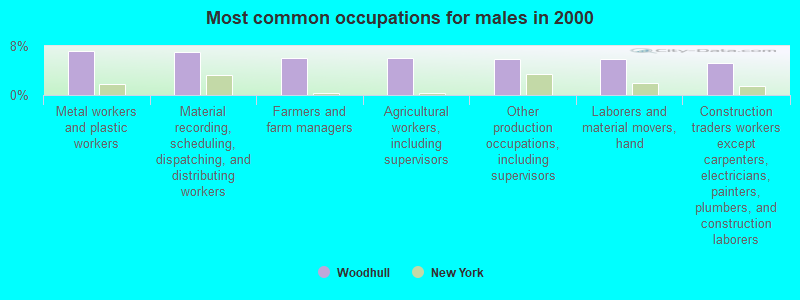
- Metal workers and plastic workers (7.2%)
- Material recording, scheduling, dispatching, and distributing workers (6.9%)
- Farmers and farm managers (6.1%)
- Agricultural workers, including supervisors (6.1%)
- Other production occupations, including supervisors (5.8%)
- Laborers and material movers, hand (5.8%)
- Construction traders workers except carpenters, electricians, painters, plumbers, and construction laborers (5.3%)
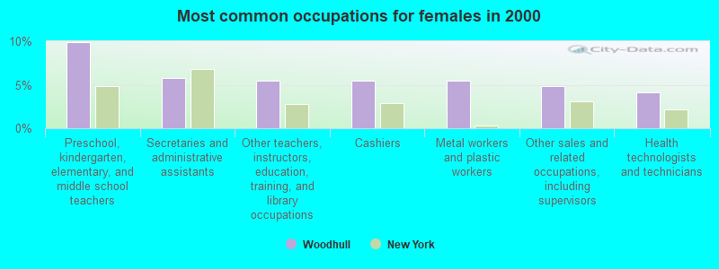
- Preschool, kindergarten, elementary, and middle school teachers (9.9%)
- Secretaries and administrative assistants (5.8%)
- Other teachers, instructors, education, training, and library occupations (5.5%)
- Cashiers (5.5%)
- Metal workers and plastic workers (5.5%)
- Other sales and related occupations, including supervisors (4.8%)
- Health technologists and technicians (4.1%)
Average climate in Woodhull, New York
Based on data reported by over 4,000 weather stations


(lower is better)
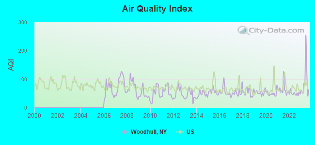
Air Quality Index (AQI) level in 2023 was 91.9. This is worse than average.
| City: | 91.9 |
| U.S.: | 72.6 |
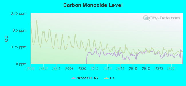
Carbon Monoxide (CO) [ppm] level in 2023 was 0.156. This is significantly better than average. Closest monitor was 9.4 miles away from the city center.
| City: | 0.156 |
| U.S.: | 0.251 |
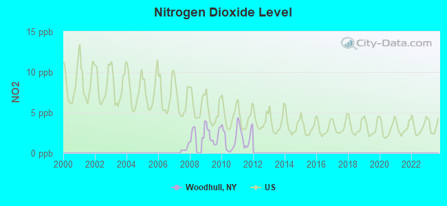
Nitrogen Dioxide (NO2) [ppb] level in 2011 was 2.25. This is significantly better than average. Closest monitor was 9.4 miles away from the city center.
| City: | 2.25 |
| U.S.: | 5.11 |
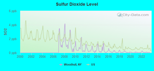
Sulfur Dioxide (SO2) [ppb] level in 2023 was 0.0309. This is significantly better than average. Closest monitor was 9.4 miles away from the city center.
| City: | 0.0309 |
| U.S.: | 1.5147 |
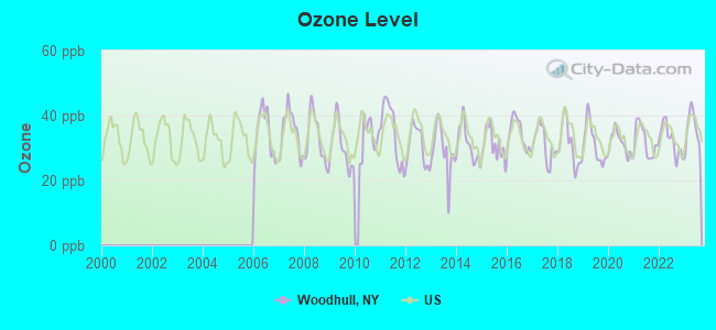
Ozone [ppb] level in 2023 was 35.9. This is about average. Closest monitor was 9.4 miles away from the city center.
| City: | 35.9 |
| U.S.: | 33.3 |
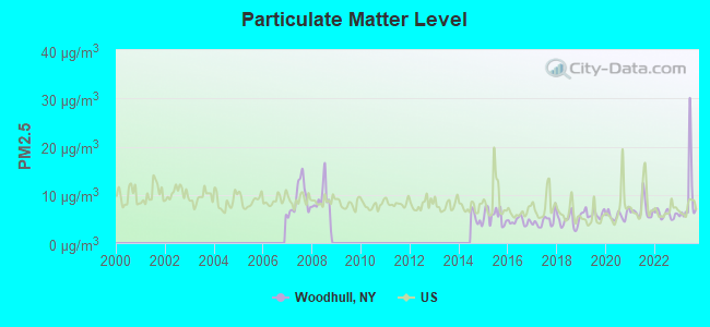
Particulate Matter (PM2.5) [µg/m3] level in 2023 was 9.50. This is about average. Closest monitor was 9.4 miles away from the city center.
| City: | 9.50 |
| U.S.: | 8.11 |
Tornado activity:
Woodhull-area historical tornado activity is near New York state average. It is 62% smaller than the overall U.S. average.
On 7/21/2003, a category F3 (max. wind speeds 158-206 mph) tornado 29.5 miles away from the Woodhull town center caused $200,000 in damages.
On 8/30/1955, a category F3 tornado 30.3 miles away from the town center caused between $5000 and $50,000 in damages.
Earthquake activity:
Woodhull-area historical earthquake activity is significantly above New York state average. It is 65% smaller than the overall U.S. average.On 9/25/1998 at 19:52:52, a magnitude 5.2 (4.8 MB, 4.3 MS, 5.2 LG, 4.5 MW, Depth: 3.1 mi, Class: Moderate, Intensity: VI - VII) earthquake occurred 160.1 miles away from the city center
On 8/23/2011 at 17:51:04, a magnitude 5.8 (5.8 MW, Depth: 3.7 mi) earthquake occurred 288.8 miles away from Woodhull center
On 10/7/1983 at 10:18:46, a magnitude 5.3 (5.1 MB, 5.3 LG, 5.1 ML) earthquake occurred 202.0 miles away from the city center
On 4/20/2002 at 10:50:47, a magnitude 5.3 (5.3 ML, Depth: 3.0 mi) earthquake occurred 251.4 miles away from the city center
On 1/31/1986 at 16:46:43, a magnitude 5.0 (5.0 MB) earthquake occurred 196.9 miles away from Woodhull center
On 4/20/2002 at 10:50:47, a magnitude 5.2 (5.2 MB, 4.2 MS, 5.2 MW, 5.0 MW) earthquake occurred 249.5 miles away from the city center
Magnitude types: regional Lg-wave magnitude (LG), body-wave magnitude (MB), local magnitude (ML), surface-wave magnitude (MS), moment magnitude (MW)
Natural disasters:
The number of natural disasters in Steuben County (20) is greater than the US average (15).Major Disasters (Presidential) Declared: 16
Emergencies Declared: 4
Causes of natural disasters: Storms: 12, Floods: 10, Hurricanes: 2, Tornadoes: 2, Blizzard: 1, Flash Flood: 1, Heavy Rain: 1, Landslide: 1, Power Outage: 1, Tropical Depression: 1, Tropical Storm: 1, Wind: 1, Winter Storm: 1, Other: 1 (Note: some incidents may be assigned to more than one category).
Colleges/universities with over 2000 students nearest to Woodhull:
- Corning Community College (about 17 miles; Corning, NY; Full-time enrollment: 3,036)
- Alfred University (about 25 miles; Alfred, NY; FT enrollment: 2,411)
- Mansfield University of Pennsylvania (about 25 miles; Mansfield, PA; FT enrollment: 2,826)
- SUNY College of Technology at Alfred (about 25 miles; Alfred, NY; FT enrollment: 3,483)
- Ithaca College (about 53 miles; Ithaca, NY; FT enrollment: 6,781)
- Cornell University (about 54 miles; Ithaca, NY; FT enrollment: 20,360)
- SUNY College at Geneseo (about 56 miles; Geneseo, NY; FT enrollment: 5,520)
Points of interest:
Notable location: Woodhull Fire Department (A). Display/hide its location on the map
Churches in Woodhull include: Woodhull Baptist Church (A), Grace Bible Fellowship (B). Display/hide their locations on the map
Cemeteries: Red Cemetery (1), Hedgesville Cemetery (2), Woodhull Cemetery (3), Elk Creek Cemetery (4), Norway Ridge Cemetery (5). Display/hide their locations on the map
Creeks: South Branch Tuscarora Creek (A), East Lick Creek (B). Display/hide their locations on the map
| This town: | 2.8 people |
| New York: | 2.6 people |
| This town: | 73.1% |
| Whole state: | 63.5% |
| This town: | 10.8% |
| Whole state: | 6.8% |
Likely homosexual households (counted as self-reported same-sex unmarried-partner households)
- Lesbian couples: 0.8% of all households
- Gay men: 0.3% of all households
| This town: | 16.3% |
| Whole state: | 14.6% |
| This town: | 7.4% |
| Whole state: | 7.4% |
Banks with branches in Woodhull (2011 data):
- Community Bank, National Association: Woodhull Branch at 1608 Main Street, branch established on 1966/08/01. Info updated 2011/06/13: Bank assets: $6,460.6 mil, Deposits: $4,840.4 mil, headquarters in Canton, NY, positive income, 175 total offices, Holding Company: Community Bank System, Inc.
For population 15 years and over in Woodhull:
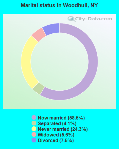
- Never married: 24.3%
- Now married: 58.5%
- Separated: 4.1%
- Widowed: 5.6%
- Divorced: 7.5%
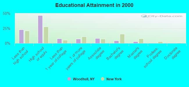
For population 25 years and over in Woodhull:
- High school or higher: 77.4%
- Bachelor's degree or higher: 7.6%
- Graduate or professional degree: 3.4%
- Unemployed: 8.8%
- Mean travel time to work (commute): 30.7 minutes
| Here: | 9.9 |
| New York average: | 14.2 |
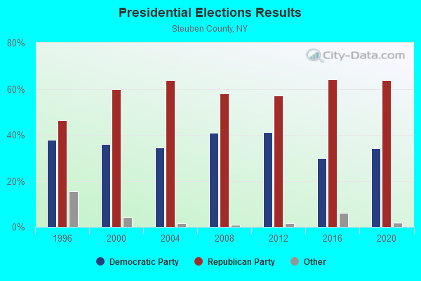
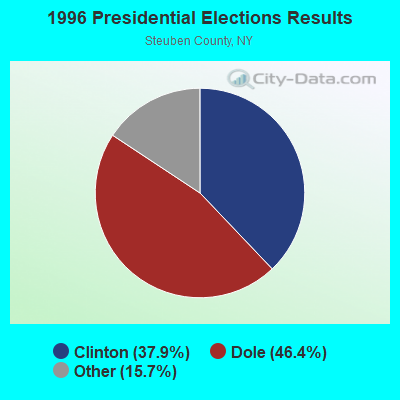
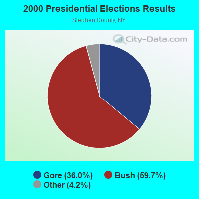
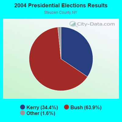
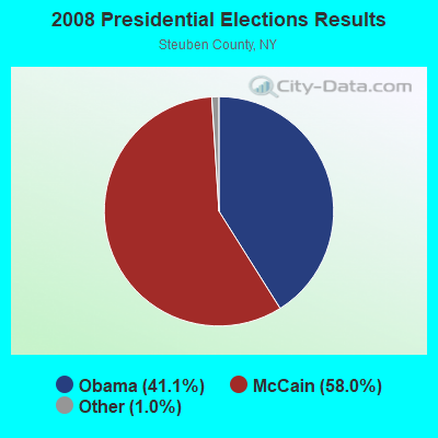
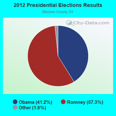
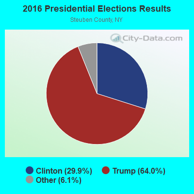
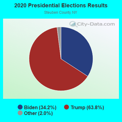
Graphs represent county-level data. Detailed 2008 Election Results
Religion statistics for Woodhull, NY (based on Steuben County data)
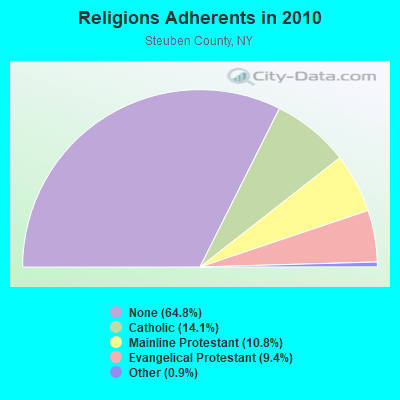
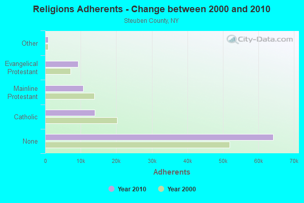
| Religion | Adherents | Congregations |
|---|---|---|
| Catholic | 13,963 | 11 |
| Mainline Protestant | 10,652 | 70 |
| Evangelical Protestant | 9,272 | 72 |
| Other | 857 | 8 |
| Orthodox | 65 | 1 |
| None | 64,181 | - |
Food Environment Statistics:
| This county: | 2.48 / 10,000 pop. |
| New York: | 4.13 / 10,000 pop. |
| This county: | 0.10 / 10,000 pop. |
| New York: | 0.06 / 10,000 pop. |
| Steuben County: | 0.72 / 10,000 pop. |
| New York: | 0.92 / 10,000 pop. |
| Here: | 4.24 / 10,000 pop. |
| New York: | 1.68 / 10,000 pop. |
| Steuben County: | 9.00 / 10,000 pop. |
| New York: | 8.82 / 10,000 pop. |
| Steuben County: | 10.2% |
| New York: | 8.2% |
| Steuben County: | 28.3% |
| State: | 23.8% |
| This county: | 14.2% |
| State: | 15.6% |
Strongest AM radio stations in Woodhull:
- WABH (1380 AM; 10 kW; BATH, NY)
- WHHO (1320 AM; 5 kW; HORNELL, NY; Owner: BILBAT RADIO, INC.)
- WHAM (1180 AM; 50 kW; ROCHESTER, NY; Owner: CITICASTERS LICENSES, L.P.)
- WLNL (1000 AM; daytime; 5 kW; HORSEHEADS, NY; Owner: LIGHTHOUSE MEDIA, INC.)
- WWLZ (820 AM; 4 kW; HORSEHEADS, NY; Owner: CHEMUNG COUNTY RADIO, INC.)
- WWKB (1520 AM; 50 kW; BUFFALO, NY; Owner: ENTERCOM BUFFALO LICENSE, LLC)
- WLEA (1480 AM; 2 kW; HORNELL, NY; Owner: PMJ COMMUNICATIONS, INC.)
- WELM (1410 AM; 5 kW; ELMIRA, NY; Owner: PEMBROOK PINES ELMIRA, LIMITED)
- WEHH (1590 AM; 5 kW; ELMIRA HTS/HORSEHEAD, NY; Owner: PEMBROOK PINES ELMIRA, LTD.)
- WWJZ (640 AM; 50 kW; MOUNT HOLLY, NJ; Owner: ABC, INC.)
- WATS (960 AM; 5 kW; SAYRE, PA; Owner: WATS BROADCASTING, INC.)
- WCBA (1350 AM; 1 kW; CORNING, NY)
- WMCA (570 AM; 50 kW; NEW YORK, NY; Owner: SALEM MEDIA OF NEW YORK, LLC)
Strongest FM radio stations in Woodhull:
- WGMM (97.7 FM; BIG FLATS, NY; Owner: EOLIN BROADCASTING, INC.)
- WMTT (94.7 FM; TIOGA, PA; Owner: EUROPA COMMUNICATIONS, INC.)
- WCBA-FM (98.7 FM; CORNING, NY; Owner: EOLIN BROADCASTING, INC.)
- WNBQ (92.3 FM; MANSFIELD, PA; Owner: FARM & HOME BROADCASTING COMPANY)
- WZKZ (101.9 FM; ALFRED, NY; Owner: PEMBROOK PINES ELMIRA, LTD.)
- WCIK (103.1 FM; BATH, NY; Owner: FAMILY LIFE MINISTRIES, INC.)
- WNKI (106.1 FM; CORNING, NY; Owner: CHEMUNG COUNTY RADIO, INC.)
- WSQA (88.7 FM; HORNELL, NY; Owner: WSKG PUBLIC TELECOMMUNICATIONS COUNCIL)
- WKPQ (105.3 FM; HORNELL, NY; Owner: BILBAT RADIO, INC.)
- WSQE (91.1 FM; CORNING, NY; Owner: WSKG PUB. TELECOMMUNICATIONS COUNCIL)
- WVIN-FM (98.3 FM; BATH, NY; Owner: PEMBROOK PINES MASS MEDIA, NA CORP.)
- WCKR (92.1 FM; HORNELL, NY; Owner: PMJ COMMUNICATIONS, INC.)
- WDKC (101.5 FM; COVINGTON, PA; Owner: MID-ATLANTIC BROADCASTING, INC)
- WOKN (99.5 FM; SOUTHPORT, NY; Owner: PEMBROOK PINES ELMIRA, LTD.)
- WLVY (94.3 FM; ELMIRA, NY; Owner: PEMBROOK PINES ELMIRA, LTD.)
- WHGL-FM (100.3 FM; CANTON, PA; Owner: CANTROAIR COMMUNICATIONS INC.)
- WENY-FM (92.7 FM; ELMIRA, NY; Owner: EOLIN BROADCASTING, INC.)
- WDNY-FM (93.9 FM; DANSVILLE, NY; Owner: MILLER MEDIA INC.)
- W236AK (95.1 FM; CORNING, NY; Owner: EUROPA COMMUNICATIONS, INC.)
- WJQZ (103.5 FM; WELLSVILLE, NY; Owner: DBM COMMUNICATIONS, INC.)
TV broadcast stations around Woodhull:
- WETM-TV (Channel 18; ELMIRA, NY; Owner: SMITH TELEVISION OF NEW YORK LICENSE HOLDINGS, INC.)
- WYDC (Channel 48; CORNING, NY; Owner: WYDC, INC.)
- WENY-TV (Channel 36; ELMIRA, NY; Owner: LILLY BROADCASTING, L.L.C.)
- W60AD (Channel 60; SAVONA, NY; Owner: WSKG PUBLIC TELECOMMUNICATIONS COUNCIL)
- W26BF (Channel 26; ELMIRA, NY; Owner: WYDC, INC.)
- W16BE (Channel 16; HORNELL, NY; Owner: WYDC, INC.)
- W20BL (Channel 20; BATH, NY; Owner: WYDC, INC.)
Woodhull fatal accident list:
May 6, 2005 08:15 PM, Cr-101, Lat: 42.037210, Lon: -77.327920, Vehicles: 2, Persons: 6, Fatalities: 2, Drunk persons involved: 2
Oct 30, 2005 08:12 PM, Sr-417, Lat: 42.084390, Lon: -77.409940, Vehicles: 1, Persons: 8, Fatalities: 1
Aug 30, 2000 02:28 AM, Cr-101, Vehicles: 1, Persons: 2, Fatalities: 1, Drunk persons involved: 1
- National Bridge Inventory (NBI) Statistics
- 17Number of bridges
- 105ft / 32.3mTotal length
- $15,874,000Total costs
- 10,429Total average daily traffic
- 972Total average daily truck traffic
- 12,110Total future (year 2037) average daily traffic
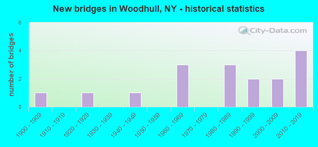
- New bridges - historical statistics
- 11900-1909
- 11920-1929
- 11940-1949
- 31960-1969
- 31980-1989
- 21990-1999
- 22000-2009
- 42010-2019
FCC Registered Antenna Towers:
6- Jerri L Janju, 5516 Freeland Road (Lat: 42.087722 Lon: -77.388639), Type: 79.3, Overall height: 76.2 m, Registrant: New York Rsa No. 3 Cellular Partnership, Network.Regulatory@verizonwireless.Com, , Alpha-retta, Phone: (770) 797-1070
- Stephanie I Jones, 5516 Freeland Road (Lat: 42.087722 Lon: -77.388639), Type: 79.3, Overall height: 76.2 m, Registrant: Verizon Wireless, Network.Regulatory@verizonwireless.Com, , Alpha-retta, Phone: (770) 797-1070
- Regulatory Manager, 5516 Freeland Road (Lat: 42.087722 Lon: -77.388639), Type: 79.3, Structure height: 36101 m, Overall height: 76.2 m, Registrant: Verizon Wireless, Network.Regulatory@verizonwireless.Com, , Alpha-retta, Phone: (770) 797-1070
- Gina Cacciatore, 5516 Freeland Road (Lat: 42.087722 Lon: -77.388639), Type: 79.3, Structure height: 36101 m, Overall height: 76.2 m, Registrant: Bell Atlantic Mobile Systems Of Alltentown, Inc., Network.Regulatory@verizonwireless.Com, Np2ne Network Engineering, Alpha-retta, Phone: (770) 797-1070
- Gina Cacciatore, 5516 Freeland Road (Lat: 42.087722 Lon: -77.388639), Type: 79.3, Structure height: 36101 m, Overall height: 76.2 m, Registrant: Bell Atlantic Mobile Systems Of Allentown, Inc, Networkregulatory@verizonwireless.Com, Np2ne Network Engineering, Alpha-retta, Phone: (770) 797-1070
- Allen Road (Lat: 42.062778 Lon: -77.401389), Type: 22.9, Overall height: 22.9 m, Registrant: Armstrong Telephone Company, Pgentile@agoc.Com, , Butle-r, Phone: (412) 283-0925
FCC Registered Private Land Mobile Towers:
1- Mead Rd (Lat: 42.059806 Lon: -77.368028), Type: Tower, Structure height: 23 m, Call Sign: WNXM287,
Assigned Frequencies: 157.740 MHz, Grant Date: 09/13/2016, Expiration Date: 10/03/2026, Registrant: Mobiletech Communications, 2365 Fire Hall Rd, Canandaigua, NY 14424, Phone: (585) 394-1482, Fax: (585) 396-2388, Email:
FCC Registered Broadcast Land Mobile Towers:
2- Woodhull Fire Station Main St (Lat: 42.071750 Lon: -77.410528), Call Sign: KNGW231,
Assigned Frequencies: 46.4000 MHz, Grant Date: 03/24/1998, Expiration Date: 06/17/2003, Cancellation Date: 09/07/2003, Registrant: Steuben County Fire Service, 3 E Pulteney Sq, Bath, NY 14810, Phone: (607) 776-9631
- Steuben Cr 99 2 Mi S (Lat: 42.049528 Lon: -77.413583), Call Sign: KEG690,
Assigned Frequencies: 48.7000 MHz, Grant Date: 12/01/2023, Expiration Date: 02/14/2034, Registrant: Eastern Gas Transmission And Storage, Inc., 925 White Oaks Blvd., Bridgeport, WV 26330, Phone: (681) 842-3701, Email:
FCC Registered Microwave Towers:
3- Woodhull, Mead Road / Harder Road (Lat: 42.062306 Lon: -77.360722), Type: Gtower, Structure height: 48.8 m, Call Sign: WQWK253,
Assigned Frequencies: 11055.0 MHz, 11095.0 MHz, Grant Date: 09/18/2015, Expiration Date: 09/18/2025, Certifier: Mark Murphy, Registrant: Zeta Broadband, Inc., Rancho Murieta, CA 95683, Phone: (916) 354-0190, Email:
- WOODHULL, 1.3 Mi. Sse Of Woodhull (Lat: 42.062556 Lon: -77.401639), Overall height: 22.9 m, Call Sign: WBB250, Licensee ID: L00064284,
Assigned Frequencies: 2162.00 MHz, 2171.60 MHz, Grant Date: 02/13/2001, Expiration Date: 02/01/2011, Cancellation Date: 03/04/2010, Registrant: Armstrong Telephone Company, 136 East Front St,, Addison, NY 14801
- Woodhull, 2 Mi S Of (Lat: 42.049500 Lon: -77.414972), Type: Building, Structure height: 6.7 m, Call Sign: WBH509,
Assigned Frequencies: 6605.00 MHz, 6635.00 MHz, Grant Date: 07/23/2019, Expiration Date: 08/01/2029, Registrant: Eastern Gas Transmission And Storage, Inc., 925 White Oaks Blvd., Bridgeport, WV 26330, Phone: (681) 842-3701, Email:
FCC Registered Amateur Radio Licenses:
1- Call Sign: KA2GOB, Grant Date: 01/22/1996, Expiration Date: 01/22/2006, Cancellation Date: 01/23/2008, Registrant: Charles R Grant, Woodhull, NY 14898
| Most common first names in Woodhull, NY among deceased individuals | ||
| Name | Count | Lived (average) |
|---|---|---|
| George | 9 | 73.4 years |
| William | 8 | 81.2 years |
| Robert | 8 | 71.3 years |
| John | 7 | 71.5 years |
| Gerald | 6 | 77.5 years |
| Howard | 6 | 80.0 years |
| Kenneth | 6 | 69.8 years |
| Mildred | 6 | 87.7 years |
| Arthur | 5 | 77.8 years |
| Harold | 5 | 70.0 years |
| Most common last names in Woodhull, NY among deceased individuals | ||
| Last name | Count | Lived (average) |
|---|---|---|
| Symonds | 10 | 76.5 years |
| Williams | 9 | 71.2 years |
| Husted | 9 | 83.6 years |
| Taft | 6 | 82.5 years |
| Clark | 6 | 81.7 years |
| Allen | 5 | 78.6 years |
| Grant | 5 | 73.6 years |
| Smith | 5 | 83.4 years |
| Brewer | 5 | 80.0 years |
| Jordan | 5 | 78.2 years |
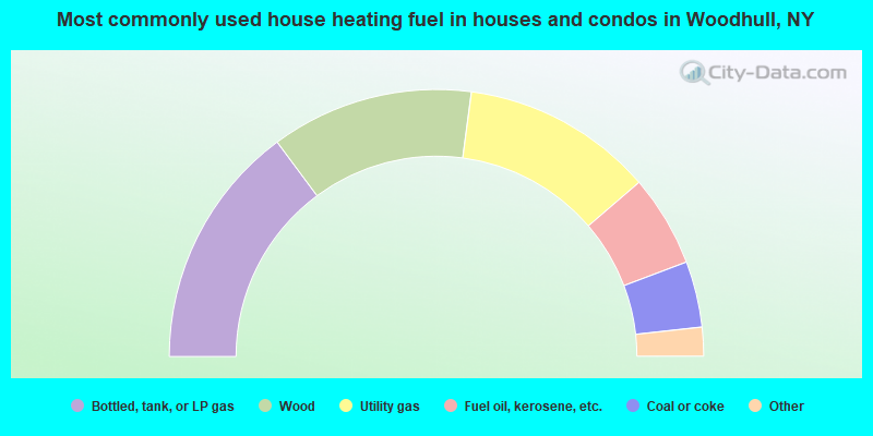
- 29.7%Bottled, tank, or LP gas
- 24.5%Wood
- 23.2%Utility gas
- 11.1%Fuel oil, kerosene, etc.
- 8.0%Coal or coke
- 3.0%Electricity
- 0.4%No fuel used
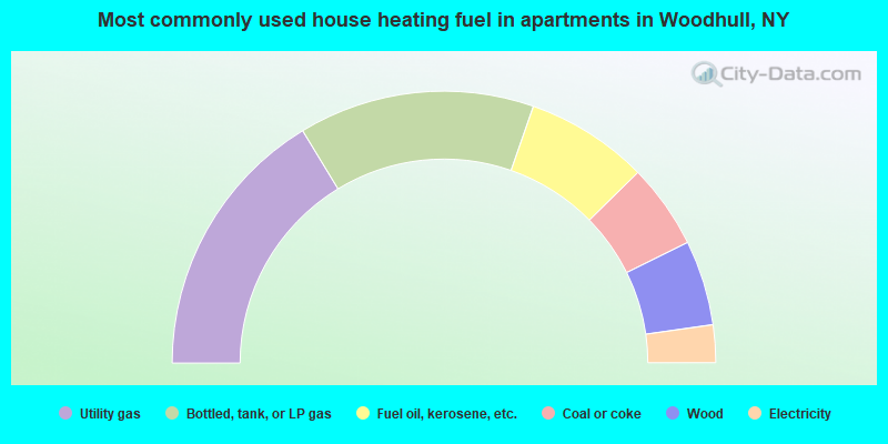
- 32.6%Utility gas
- 28.1%Bottled, tank, or LP gas
- 14.6%Fuel oil, kerosene, etc.
- 10.1%Coal or coke
- 10.1%Wood
- 4.5%Electricity
Woodhull compared to New York state average:
- Median house value significantly below state average.
- Unemployed percentage below state average.
- Black race population percentage significantly below state average.
- Hispanic race population percentage significantly below state average.
- Foreign-born population percentage significantly below state average.
- Renting percentage significantly below state average.
- Length of stay since moving in significantly above state average.
- Number of rooms per house significantly below state average.
- House age significantly below state average.
- Number of college students below state average.
- Percentage of population with a bachelor's degree or higher significantly below state average.

|
Total of 4 patent applications in 2008-2024.