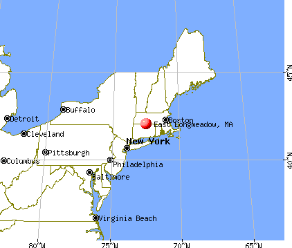
East Longmeadow, Massachusetts
East Longmeadow: 2011 Graduation moved to Baseball field due to Football track and field being reconstructed
- add
your
Submit your own pictures of this town and show them to the world
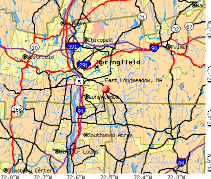
- OSM Map
- General Map
- Google Map
- MSN Map
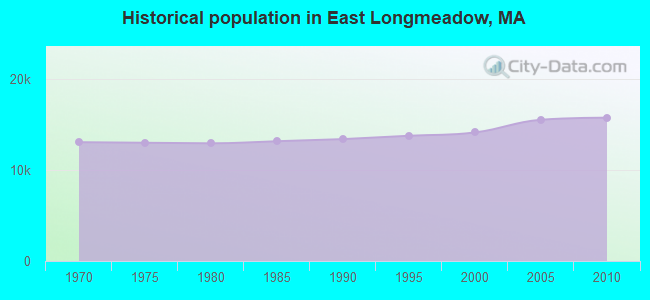
Population change since 2000: +11.5%
 |
| Males: 7,401 | |
| Females: 8,319 |
| Median resident age: | 45.0 years |
| Massachusetts median age: | 39.2 years |
Zip codes: 01028.
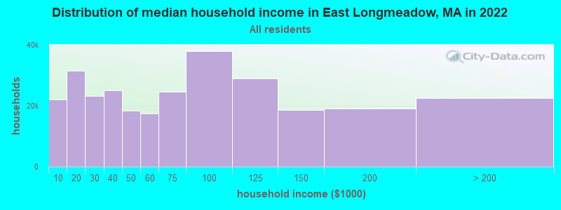
| East Longmeadow: | $100,789 |
| MA: | $94,488 |
Estimated per capita income in 2022: $48,535 (it was $27,659 in 2000)
East Longmeadow town income, earnings, and wages data
Estimated median house or condo value in 2022: $363,232 (it was $146,400 in 2000)
| East Longmeadow: | $363,232 |
| MA: | $534,700 |
Mean prices in 2022: all housing units: $315,253; detached houses: $334,901; townhouses or other attached units: $238,289; in 2-unit structures: $223,248; in 3-to-4-unit structures: $195,645; in 5-or-more-unit structures: $166,405; mobile homes: $156,908
East Longmeadow, MA residents, houses, and apartments details
Detailed information about poverty and poor residents in East Longmeadow, MA


- 14,61293.0%White alone
- 3762.4%Asian alone
- 3572.3%Hispanic
- 2121.3%Black alone
- 1380.9%Two or more races
- 160.1%Other race alone
- 90.06%American Indian alone
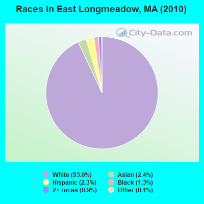
Races in East Longmeadow detailed stats: ancestries, foreign born residents, place of birth
According to our research of Massachusetts and other state lists, there were 4 registered sex offenders living in East Longmeadow, Massachusetts as of April 26, 2024.
The ratio of all residents to sex offenders in East Longmeadow is 3,930 to 1.
The ratio of registered sex offenders to all residents in this city is much lower than the state average.
Type |
2009 |
2010 |
2011 |
2012 |
2013 |
2014 |
2015 |
2016 |
2017 |
2018 |
2019 |
2020 |
2021 |
2022 |
|---|---|---|---|---|---|---|---|---|---|---|---|---|---|---|
| Murders (per 100,000) | 0 (0.0) | 0 (0.0) | 0 (0.0) | 0 (0.0) | 0 (0.0) | 0 (0.0) | 0 (0.0) | 0 (0.0) | 0 (0.0) | 0 (0.0) | 1 (6.1) | 0 (0.0) | 0 (0.0) | 0 (0.0) |
| Rapes (per 100,000) | 1 (6.4) | 4 (25.4) | 0 (0.0) | 1 (6.3) | 3 (18.8) | 6 (37.3) | 4 (24.7) | 7 (43.0) | 5 (30.7) | 4 (24.4) | 6 (36.9) | 4 (24.7) | 11 (67.5) | 8 (48.6) |
| Robberies (per 100,000) | 3 (19.2) | 8 (50.9) | 2 (12.6) | 6 (37.8) | 0 (0.0) | 0 (0.0) | 3 (18.5) | 2 (12.3) | 3 (18.4) | 6 (36.6) | 6 (36.9) | 3 (18.5) | 3 (18.4) | 4 (24.3) |
| Assaults (per 100,000) | 24 (153.9) | 22 (139.9) | 12 (75.9) | 18 (113.4) | 25 (156.8) | 15 (93.2) | 11 (67.8) | 11 (67.6) | 17 (104.4) | 18 (109.8) | 11 (67.6) | 5 (30.9) | 15 (92.1) | 22 (133.7) |
| Burglaries (per 100,000) | 90 (577.1) | 65 (413.5) | 65 (411.0) | 79 (497.8) | 58 (363.7) | 49 (304.5) | 30 (185.0) | 33 (202.9) | 51 (313.1) | 40 (243.9) | 28 (172.1) | 19 (117.4) | 36 (221.0) | 29 (176.2) |
| Thefts (per 100,000) | 308 (1,975) | 270 (1,718) | 263 (1,663) | 274 (1,726) | 227 (1,424) | 198 (1,230) | 177 (1,091) | 155 (952.8) | 214 (1,314) | 212 (1,293) | 132 (811.4) | 134 (828.1) | 117 (718.4) | 190 (1,154) |
| Auto thefts (per 100,000) | 22 (141.1) | 14 (89.1) | 6 (37.9) | 6 (37.8) | 12 (75.3) | 13 (80.8) | 8 (49.3) | 6 (36.9) | 14 (86.0) | 10 (61.0) | 12 (73.8) | 15 (92.7) | 21 (128.9) | 12 (72.9) |
| Arson (per 100,000) | 0 (0.0) | 2 (12.7) | 0 (0.0) | 2 (12.6) | 1 (6.3) | 1 (6.2) | 1 (6.2) | 0 (0.0) | 2 (12.3) | 0 (0.0) | 2 (12.3) | 3 (18.5) | 0 (0.0) | 0 (0.0) |
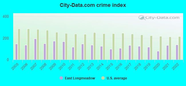
| City-Data.com crime index | 172.4 | 168.4 | 117.3 | 146.0 | 134.8 | 125.5 | 99.4 | 106.9 | 132.3 | 126.1 | 116.8 | 80.3 | 132.5 | 137.3 |
The City-Data.com crime index weighs serious crimes and violent crimes more heavily. Higher means more crime, U.S. average is 246.1. It adjusts for the number of visitors and daily workers commuting into cities.
Crime rate in East Longmeadow detailed stats: murders, rapes, robberies, assaults, burglaries, thefts, arson
Full-time law enforcement employees in 2021, including police officers: 29 (26 officers - 26 male; 0 female).
| Officers per 1,000 residents here: | 1.60 |
| Massachusetts average: | 2.53 |
 Recent articles from our blog. Our writers, many of them Ph.D. graduates or candidates, create easy-to-read articles on a wide variety of topics.

 | Oklahoma to (likely Western) Massachusetts - Beginning Research (274 replies) |
| Good and affordable Western Mass school districts? Where should we live? (37 replies) |
| New Job in Springfield MA (Baystate) Housing Options (33 replies) |
| Longmeadow, MA Daycare? (1 reply) |
| Possibilities in Western Mass for mid-life couple w/no kids (22 replies) |
| Springfield #41 deadliest city. (123 replies) |
Latest news from East Longmeadow, MA collected exclusively by city-data.com from local newspapers, TV, and radio stations
Ancestries: Irish (25.7%), Italian (22.4%), English (14.0%), French (11.9%), Polish (9.7%), German (9.1%).
Current Local Time: EST time zone
Incorporated in 1894
Elevation: 226 feet
Land area: 13.0 square miles.
Population density: 1,212 people per square mile (low).
614 residents are foreign born (2.9% Europe, 0.8% Asia).
| This town: | 4.4% |
| Massachusetts: | 12.2% |
| East Longmeadow town: | 1.9% ($2,739) |
| Massachusetts: | 1.3% ($2,336) |
Nearest city with pop. 50,000+: Springfield, MA  (3.7 miles , pop. 152,082).
Nearest city with pop. 200,000+: Boston, MA (74.9 miles , pop. 589,141).
Nearest city with pop. 1,000,000+: Bronx, NY (110.1 miles , pop. 1,332,650).
Nearest cities:
), ), ), )Latitude: 42.07 N, Longitude: 72.51 W
Area code: 413

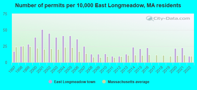
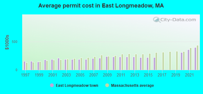
Single-family new house construction building permits:
- 2022: 14 buildings, average cost: $397,700
- 2021: 32 buildings, average cost: $359,600
- 2020: 31 buildings, average cost: $307,300
- 2016: 32 buildings, average cost: $220,400
- 2015: 30 buildings, average cost: $220,400
- 2014: 33 buildings, average cost: $220,400
- 2013: 18 buildings, average cost: $232,800
- 2012: 14 buildings, average cost: $232,800
- 2011: 14 buildings, average cost: $233,000
- 2010: 19 buildings, average cost: $231,900
- 2009: 18 buildings, average cost: $235,900
- 2008: 18 buildings, average cost: $210,500
- 2007: 35 buildings, average cost: $201,900
- 2006: 51 buildings, average cost: $190,300
- 2005: 58 buildings, average cost: $186,200
- 2004: 58 buildings, average cost: $187,500
- 2003: 55 buildings, average cost: $187,200
- 2002: 63 buildings, average cost: $212,100
- 2001: 72 buildings, average cost: $187,100
- 2000: 55 buildings, average cost: $180,800
- 1999: 40 buildings, average cost: $144,000
- 1998: 35 buildings, average cost: $157,200
- 1997: 24 buildings, average cost: $153,200
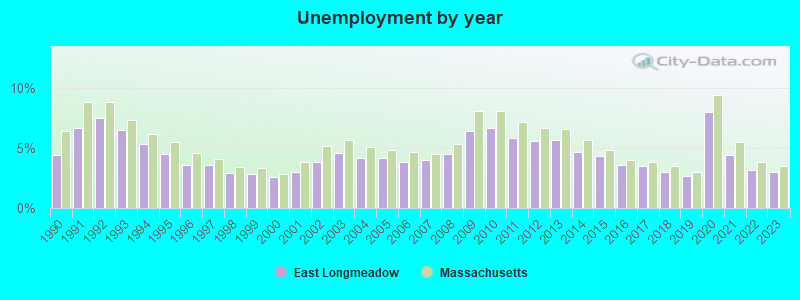
| Here: | 3.0% |
| Massachusetts: | 3.5% |
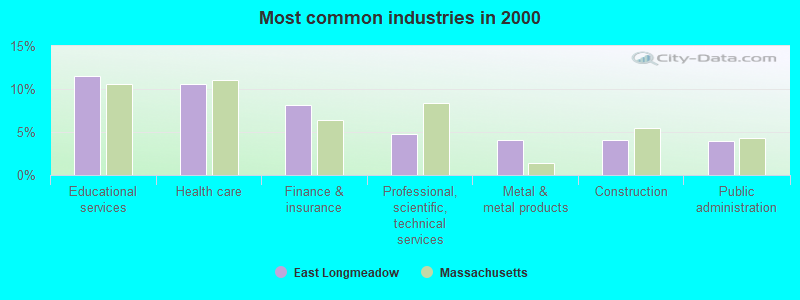
- Educational services (11.5%)
- Health care (10.6%)
- Finance & insurance (8.2%)
- Professional, scientific, technical services (4.7%)
- Metal & metal products (4.0%)
- Construction (4.0%)
- Public administration (4.0%)
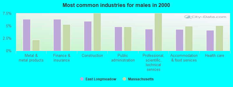
- Metal & metal products (6.3%)
- Finance & insurance (6.3%)
- Construction (5.9%)
- Public administration (4.8%)
- Professional, scientific, technical services (4.3%)
- Accommodation & food services (4.3%)
- Health care (4.1%)
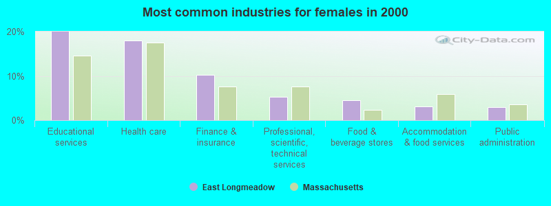
- Educational services (20.0%)
- Health care (17.9%)
- Finance & insurance (10.2%)
- Professional, scientific, technical services (5.2%)
- Food & beverage stores (4.4%)
- Accommodation & food services (3.0%)
- Public administration (3.0%)
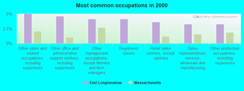
- Other sales and related occupations, including supervisors (5.0%)
- Other office and administrative support workers, including supervisors (4.6%)
- Other management occupations, except farmers and farm managers (4.2%)
- Registered nurses (4.2%)
- Retail sales workers, except cashiers (3.7%)
- Sales representatives, services, wholesale and manufacturing (3.3%)
- Other production occupations, including supervisors (3.3%)
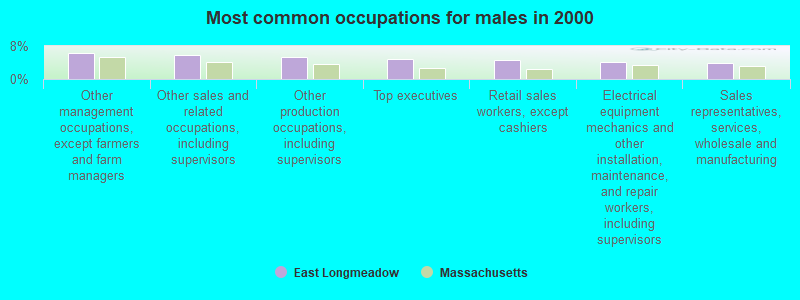
- Other management occupations, except farmers and farm managers (6.3%)
- Other sales and related occupations, including supervisors (5.7%)
- Other production occupations, including supervisors (5.3%)
- Top executives (4.8%)
- Retail sales workers, except cashiers (4.5%)
- Electrical equipment mechanics and other installation, maintenance, and repair workers, including supervisors (4.1%)
- Sales representatives, services, wholesale and manufacturing (4.0%)
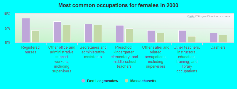
- Registered nurses (8.4%)
- Other office and administrative support workers, including supervisors (7.3%)
- Secretaries and administrative assistants (6.5%)
- Preschool, kindergarten, elementary, and middle school teachers (5.9%)
- Other sales and related occupations, including supervisors (4.2%)
- Other teachers, instructors, education, training, and library occupations (4.2%)
- Cashiers (3.3%)
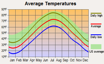
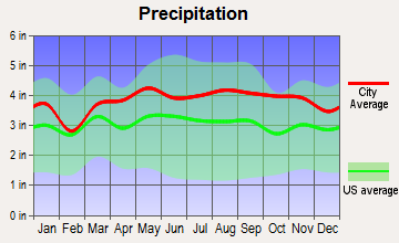
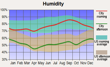
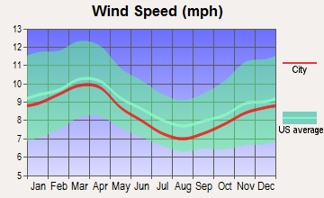
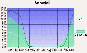
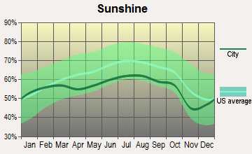
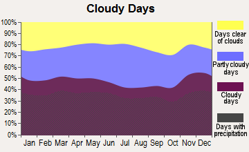
Average climate in East Longmeadow, Massachusetts
Based on data reported by over 4,000 weather stations
(lower is better)
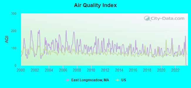
Air Quality Index (AQI) level in 2022 was 78.6. This is about average.
| City: | 78.6 |
| U.S.: | 72.6 |
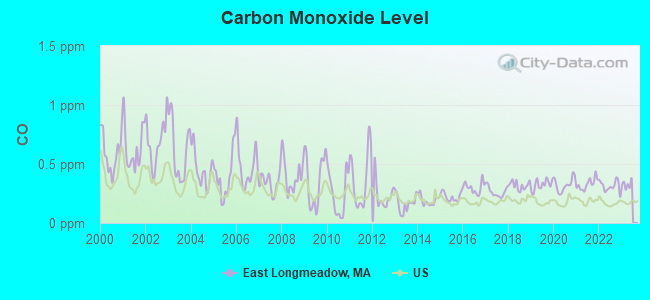
Carbon Monoxide (CO) [ppm] level in 2022 was 0.312. This is worse than average. Closest monitor was 4.5 miles away from the city center.
| City: | 0.312 |
| U.S.: | 0.251 |
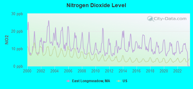
Nitrogen Dioxide (NO2) [ppb] level in 2022 was 10.2. This is significantly worse than average. Closest monitor was 4.5 miles away from the city center.
| City: | 10.2 |
| U.S.: | 5.1 |

Sulfur Dioxide (SO2) [ppb] level in 2022 was 0.147. This is significantly better than average. Closest monitor was 3.5 miles away from the city center.
| City: | 0.147 |
| U.S.: | 1.515 |
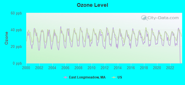
Ozone [ppb] level in 2022 was 29.9. This is about average. Closest monitor was 4.5 miles away from the city center.
| City: | 29.9 |
| U.S.: | 33.3 |
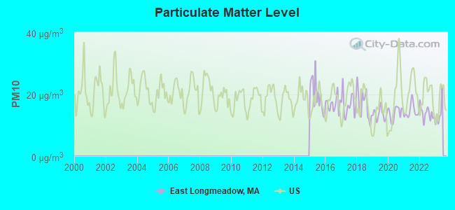
Particulate Matter (PM10) [µg/m3] level in 2022 was 13.8. This is better than average. Closest monitor was 3.5 miles away from the city center.
| City: | 13.8 |
| U.S.: | 19.2 |
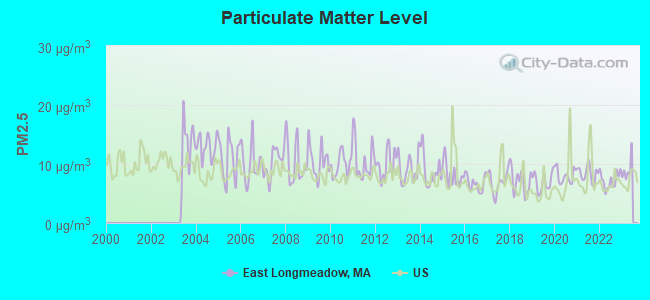
Particulate Matter (PM2.5) [µg/m3] level in 2022 was 7.23. This is about average. Closest monitor was 5.1 miles away from the city center.
| City: | 7.23 |
| U.S.: | 8.11 |
Tornado activity:
East Longmeadow-area historical tornado activity is above Massachusetts state average. It is 10% smaller than the overall U.S. average.
On 10/3/1979, a category F4 (max. wind speeds 207-260 mph) tornado 9.8 miles away from the East Longmeadow town center killed 3 people and injured 500 people and caused between $50,000,000 and $500,000,000 in damages.
On 6/9/1953, a category F4 tornado 32.9 miles away from the town center killed 90 people and injured 1228 people and caused between $50,000,000 and $500,000,000 in damages.
Earthquake activity:
East Longmeadow-area historical earthquake activity is significantly above Massachusetts state average. It is 70% smaller than the overall U.S. average.On 10/7/1983 at 10:18:46, a magnitude 5.3 (5.1 MB, 5.3 LG, 5.1 ML, Class: Moderate, Intensity: VI - VII) earthquake occurred 160.0 miles away from the city center
On 4/20/2002 at 10:50:47, a magnitude 5.3 (5.3 ML, Depth: 3.0 mi) earthquake occurred 179.4 miles away from the city center
On 4/20/2002 at 10:50:47, a magnitude 5.2 (5.2 MB, 4.2 MS, 5.2 MW, 5.0 MW) earthquake occurred 178.1 miles away from the city center
On 1/19/1982 at 00:14:42, a magnitude 4.7 (4.5 MB, 4.7 MD, 4.5 LG, Class: Light, Intensity: IV - V) earthquake occurred 109.4 miles away from the city center
On 10/16/2012 at 23:12:25, a magnitude 4.7 (4.7 ML, Depth: 10.0 mi) earthquake occurred 141.6 miles away from East Longmeadow center
On 8/23/2011 at 17:51:04, a magnitude 5.8 (5.8 MW, Depth: 3.7 mi) earthquake occurred 406.5 miles away from the city center
Magnitude types: regional Lg-wave magnitude (LG), body-wave magnitude (MB), duration magnitude (MD), local magnitude (ML), surface-wave magnitude (MS), moment magnitude (MW)
Natural disasters:
The number of natural disasters in Hampden County (22) is greater than the US average (15).Major Disasters (Presidential) Declared: 12
Emergencies Declared: 9
Causes of natural disasters: Storms: 6, Floods: 5, Hurricanes: 5, Snowstorms: 4, Winter Storms: 4, Blizzards: 2, Snows: 2, Snowfall: 1, Tornado: 1, Tropical Storm: 1, Wind: 1, Other: 1 (Note: some incidents may be assigned to more than one category).
Hospitals and medical centers in East Longmeadow:
- CAPUANO HOME HEALTH CARE INC (265 BENTON DRIVE # 201)
- RENAISSANCE HOME HEALTH INC (THE MEADOWS, 200 N MAIN ST, SUITE 1203)
- EAST LONGMEADOW SKILLED NURSING CENTER (305 MAPLE STREET)
- REDSTONE REHAB AND NURSING CENTER (135 BENTON DRIVE)
- WINGATE AT EAST LONGMEADOW REHAB AND SKILLED NUR RES (32 CHESTNUT STREET)
Amtrak stations near East Longmeadow:
- 6 miles: SPRINGFIELD (66 LYMAN ST.) . Services: ticket office, partially wheelchair accessible, enclosed waiting area, public restrooms, public payphones, full-service food facilities, snack bar, vending machines, ATM, paid short-term parking, paid long-term parking, call for car rental service, taxi stand, intercity bus service, public transit connection.
- 12 miles: WINDSOR LOCKS (S. MAIN ST. (RTE. 159)) . Services: public payphones, free short-term parking, free long-term parking, call for car rental service, call for taxi service, public transit connection.
- 17 miles: WINDSOR (41 CENTRAL ST.) . Services: enclosed waiting area, public restrooms, public payphones, free short-term parking, call for car rental service, call for taxi service, public transit connection.
Colleges/universities with over 2000 students nearest to East Longmeadow:
- Western New England University (about 4 miles; Springfield, MA; Full-time enrollment: 3,477)
- Springfield College (about 4 miles; Springfield, MA; FT enrollment: 3,144)
- Bay Path College (about 4 miles; Longmeadow, MA; FT enrollment: 2,085)
- American International College (about 5 miles; Springfield, MA; FT enrollment: 2,733)
- Springfield Technical Community College (about 5 miles; Springfield, MA; FT enrollment: 4,750)
- Holyoke Community College (about 12 miles; Holyoke, MA; FT enrollment: 4,911)
- Mount Holyoke College (about 14 miles; South Hadley, MA; FT enrollment: 2,573)
Public high school in East Longmeadow:
- EAST LONGMEADOW HIGH (Students: 938, Location: 180 MAPLE STREET, Grades: 9-12)
Public elementary/middle schools in East Longmeadow:
- BIRCHLAND PARK (Students: 669, Location: 50 HANWARD HILL, Grades: 6-8)
- MEADOW BROOK (Students: 628, Location: 607 PARKER STREET, Grades: PK-2)
- MOUNTAIN VIEW (Students: 315, Location: 77 HAMPDEN RD, Grades: 3-5)
- MAPLESHADE (Students: 309, Location: 175 MAPLESHADE AVENUE, Grades: 3-5)
Library in East Longmeadow:
User-submitted facts and corrections:
- please add under college/university: Artistic Dance Conservatory, 357A Shaker Road, East Longmeadow, MA 01028, 413.525.8810 www.artisticdanceconservatory.com
Points of interest:
Notable locations in East Longmeadow: East Longmeadow Industrial Park (A), Garden Plaza (B), Heritage Park Plaza (C), Elmcrest Country Club (D), East Longmeadow Fire Department (E), East Longmeadow Public Library (F), East Longmeadow Town Hall (G). Display/hide their locations on the map
Shopping Centers: Garden Plaza Shopping Center (1), Heritage Park Plaza Shopping Center (2), Dunbar Shopping Center (3), North Main Shopping Center (4). Display/hide their locations on the map
Churches in East Longmeadow include: Saint Pauls Church (A), Saint Lukes Greek Orthodox Church (B), Saint Josephs Church (C), New Life Baptist Church (D), First Congregational Church of East Longmeadow (E), First Baptist Church (F), Faith Tabernacle Church (G). Display/hide their locations on the map
Lakes and reservoirs: Red Stone Lake (A), Jawbuck Brook Reservoir (B). Display/hide their locations on the map
Parks in East Longmeadow include: Heritage Park (1), Leahy Field (2). Display/hide their locations on the map
Tourist attractions: East Longmeadow Town - Public Schools- East Longmeadow High School- Lib (Cultural Attractions- Events- & Facilities; 180 Maple Street), Norcross Center the Friends Of (89 Maple Street).
Birthplace of: Pete Franklin - Sports Radio Talk Show Host, James Thorpe (soccer) - Soccer player.
Drinking water stations with addresses in East Longmeadow and their reported violations in the past:
EAST LONGMEADOW DPW WATER DEPT (Population served: 15,858, Purch surface water):Past health violations:Past monitoring violations:
- MCL, Monthly (TCR) - In JUL-2009, Contaminant: Coliform. Follow-up actions: St AO (w/o penalty) issued (AUG-26-2009)
- Follow-up Or Routine LCR Tap M/R - In OCT-01-2005, Contaminant: Lead and Copper Rule. Follow-up actions: St AO (w/o penalty) issued (JAN-03-2006), St Compliance achieved (JAN-03-2006)
- One minor monitoring violation
| This town: | 2.6 people |
| Massachusetts: | 2.5 people |
| This town: | 72.8% |
| Whole state: | 63.0% |
| This town: | 4.1% |
| Whole state: | 7.0% |
Likely homosexual households (counted as self-reported same-sex unmarried-partner households)
- Lesbian couples: 0.4% of all households
- Gay men: 0.2% of all households
| This town: | 3.4% |
| Whole state: | 9.3% |
| This town: | 1.8% |
| Whole state: | 4.4% |
13 people in group homes intended for adults in 2010
206 people in nursing homes in 2000
4 people in homes for the mentally retarded in 2000
Banks with most branches in East Longmeadow (2011 data):
- RBS Citizens, National Association: East Longmeadow Stop & Shop Branch at 470 N Main St, branch established on 2006/09/21. Info updated 2007/09/19: Bank assets: $106,940.6 mil, Deposits: $75,690.2 mil, headquarters in Providence, RI, positive income, 1135 total offices, Holding Company: Uk Financial Investments Limited
- Bank of America, National Association: East Longmeadow Branch at 431 North Main Street, branch established on 1983/05/13. Info updated 2009/11/18: Bank assets: $1,451,969.3 mil, Deposits: $1,077,176.8 mil, headquarters in Charlotte, NC, positive income, 5782 total offices, Holding Company: Bank Of America Corporation
- Webster Bank, National Association: East Longmeadow Branch at 20 North Main Street, branch established on 2007/12/17. Info updated 2008/12/23: Bank assets: $18,674.3 mil, Deposits: $13,861.5 mil, headquarters in Waterbury, CT, positive income, Commercial Lending Specialization, 167 total offices, Holding Company: Webster Financial Corporation
- PeoplesBank: East Longmeadow Branch at 201 North Main Street, branch established on 2004/10/04. Info updated 2007/02/12: Bank assets: $1,653.1 mil, Deposits: $1,224.2 mil, headquarters in Holyoke, MA, positive income, Commercial Lending Specialization, 18 total offices, Holding Company: Peoplesbancorp, Mhc
- Westfield Bank: East Longmeadow Branch at 382 North Main Street, branch established on 1997/03/15. Info updated 2011/07/21: Bank assets: $1,259.3 mil, Deposits: $733.6 mil, headquarters in Westfield, MA, positive income, Commercial Lending Specialization, 12 total offices
- TD Bank, National Association: East Longmeadow Branch at 465 North Main Street, branch established on 1970/11/12. Info updated 2010/10/04: Bank assets: $188,912.6 mil, Deposits: $153,149.8 mil, headquarters in Wilmington, DE, positive income, 1314 total offices, Holding Company: Toronto-Dominion Bank, The
- Berkshire Bank: East Longmeadow Branch at 72 Shaker Road, branch established on 2001/03/12. Info updated 2011/08/24: Bank assets: $3,955.6 mil, Deposits: $3,176.2 mil, headquarters in Pittsfield, MA, positive income, Commercial Lending Specialization, 64 total offices
- United Bank: East Longmeadow Branch at 94 Shaker Road, branch established on 2008/01/28. Info updated 2012/01/20: Bank assets: $1,617.9 mil, Deposits: $1,235.2 mil, headquarters in West Springfield, MA, positive income, Commercial Lending Specialization, 25 total offices
- First Niagara Bank, National Association: East Longmeadow Branch at 6 Somers Rd, branch established on 1994/08/29. Info updated 2011/06/09: Bank assets: $32,750.6 mil, Deposits: $19,595.4 mil, headquarters in Buffalo, NY, positive income, Commercial Lending Specialization, 351 total offices, Holding Company: First Niagara Financial Group, Inc.
For population 15 years and over in East Longmeadow:
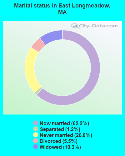
- Never married: 20.8%
- Now married: 62.2%
- Separated: 1.2%
- Widowed: 10.3%
- Divorced: 5.5%
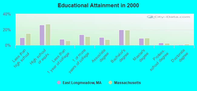
For population 25 years and over in East Longmeadow:
- High school or higher: 90.4%
- Bachelor's degree or higher: 32.8%
- Graduate or professional degree: 13.0%
- Unemployed: 2.6%
- Mean travel time to work (commute): 21.9 minutes
| Here: | 10.6 |
| Massachusetts average: | 13.1 |
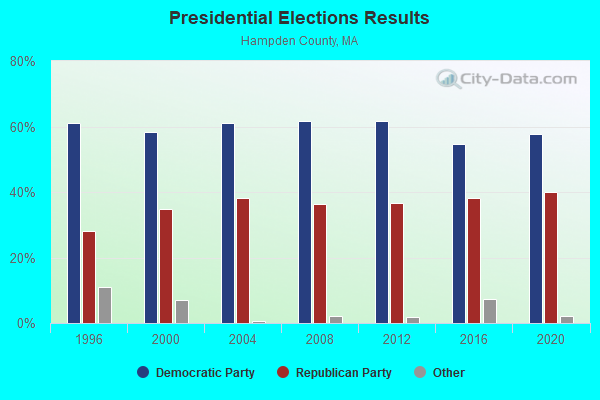
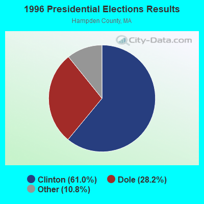
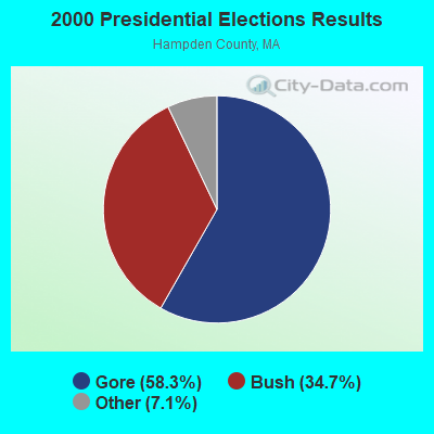
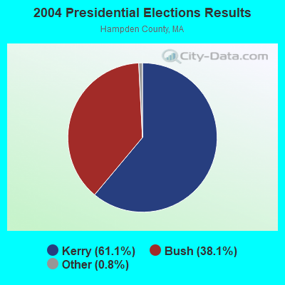
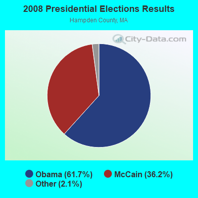
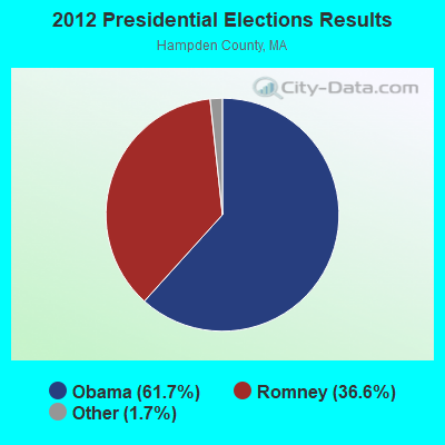
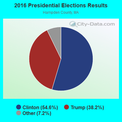
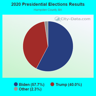
Graphs represent county-level data. Detailed 2008 Election Results
Political contributions by individuals in East Longmeadow, MA
Religion statistics for East Longmeadow, MA (based on Hampden County data)
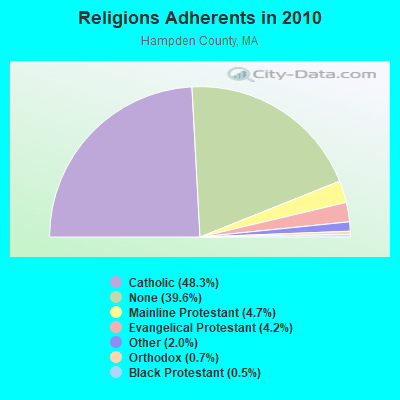
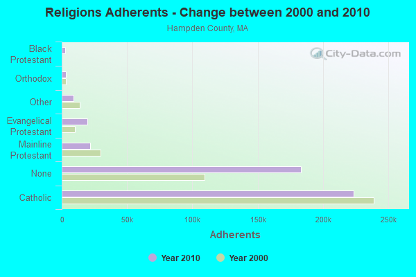
| Religion | Adherents | Congregations |
|---|---|---|
| Catholic | 223,685 | 65 |
| Mainline Protestant | 21,962 | 88 |
| Evangelical Protestant | 19,438 | 114 |
| Other | 9,140 | 31 |
| Orthodox | 3,406 | 10 |
| Black Protestant | 2,491 | 16 |
| None | 183,368 | - |
Food Environment Statistics:
| Hampden County: | 1.95 / 10,000 pop. |
| Massachusetts: | 1.98 / 10,000 pop. |
| Here: | 0.04 / 10,000 pop. |
| Massachusetts: | 0.05 / 10,000 pop. |
| Hampden County: | 1.87 / 10,000 pop. |
| Massachusetts: | 2.22 / 10,000 pop. |
| Hampden County: | 2.43 / 10,000 pop. |
| State: | 1.77 / 10,000 pop. |
| Here: | 7.27 / 10,000 pop. |
| Massachusetts: | 8.76 / 10,000 pop. |
| Hampden County: | 9.2% |
| Massachusetts: | 8.1% |
| Hampden County: | 25.9% |
| State: | 22.5% |
| Hampden County: | 16.2% |
| Massachusetts: | 16.5% |
3.64% of this county's 2021 resident taxpayers lived in other counties in 2020 ($58,474 average adjusted gross income)
| Here: | 3.64% |
| Massachusetts average: | 6.35% |
0.02% of residents moved from foreign countries ($105 average AGI)
Hampden County: 0.02% Massachusetts average: 0.01%
Top counties from which taxpayers relocated into this county between 2020 and 2021:
| from Hampshire County, MA | |
| from Hartford County, CT | |
| from Worcester County, MA |
4.26% of this county's 2020 resident taxpayers moved to other counties in 2021 ($66,146 average adjusted gross income)
| Here: | 4.26% |
| Massachusetts average: | 7.18% |
0.03% of residents moved to foreign countries ($223 average AGI)
Hampden County: 0.03% Massachusetts average: 0.02%
Top counties to which taxpayers relocated from this county between 2020 and 2021:
| to Hampshire County, MA | |
| to Hartford County, CT | |
| to Worcester County, MA |
| Businesses in East Longmeadow, MA | ||||
| Name | Count | Name | Count | |
|---|---|---|---|---|
| Ace Hardware | 1 | Panera Bread | 1 | |
| CVS | 1 | Staples | 1 | |
| Dunkin Donuts | 1 | Starbucks | 1 | |
| FedEx | 2 | Stop & Shop | 1 | |
| GNC | 1 | Subway | 2 | |
| GameStop | 1 | UPS | 3 | |
| H&R Block | 1 | Vans | 1 | |
| KFC | 1 | Walgreens | 1 | |
Strongest AM radio stations in East Longmeadow:
- WHNP (1600 AM; 2 kW; EAST LONGMEADOW, MA; Owner: SAGA COMMUNICATIONS OF NEW ENGLAND, LLC)
- WNNZ (640 AM; 50 kW; WESTFIELD, MA; Owner: CLEAR CHANNEL BROADCASTING LICENSES, INC.)
- WSPR (1270 AM; 5 kW; SPRINGFIELD, MA; Owner: ANTONIO F. AND HELENA R. GOIS, TENANTS BY THE ENTIRETY)
- WACE (730 AM; 5 kW; CHICOPEE, MA; Owner: CARTER BROADCASTING CORP.)
- WTIC (1080 AM; 50 kW; HARTFORD, CT; Owner: INFINITY RADIO OPERATIONS INC.)
- WCRN (830 AM; 50 kW; WORCESTER, MA; Owner: CARTER BROADCASTING CORPORATION)
- WHYN (560 AM; 5 kW; SPRINGFIELD, MA; Owner: CLEAR CHANNEL BROADCASTING LICENSES, INC.)
- WVNE (760 AM; daytime; 25 kW; LEICESTER, MA; Owner: BLOUNT MASSCOM, INC.)
- WALE (990 AM; 50 kW; GREENVILLE, RI; Owner: NORTH AMERICAN BROADCASTING CO., INC.)
- WMAS (1450 AM; 1 kW; SPRINGFIELD, MA; Owner: LAPPIN COMMUNICATIONS, INC.)
- WACM (1490 AM; 1 kW; WEST SPRINGFIELD, MA; Owner: ANTONIO F. GOIS)
- WEEI (850 AM; 50 kW; BOSTON, MA; Owner: ENTERCOM BOSTON LICENSE, LLC)
- WRKO (680 AM; 50 kW; BOSTON, MA; Owner: ENTERCOM BOSTON LICENSE, LLC)
Strongest FM radio stations in East Longmeadow:
- WAQY (102.1 FM; SPRINGFIELD, MA; Owner: SAGA COMMUNICATIONS OF NEW ENGLAND, LLC)
- WHYN-FM (93.1 FM; SPRINGFIELD, MA; Owner: CLEAR CHANNEL BROADCASTING LICENSES, INC.)
- WRNX (100.9 FM; AMHERST, MA; Owner: WESTERN MASSACHUSETTS RADIO COMPANY)
- WPKX (97.9 FM; ENFIELD, CT; Owner: CAPSTAR TX LIMITED PARTNERSHIP)
- WMAS-FM (94.7 FM; SPRINGFIELD, MA; Owner: LAPPIN COMMUNICATIONS, INC.)
- WFCR (88.5 FM; AMHERST, MA; Owner: UNIVERSITY OF MASSACHUSETTS)
- WRCH (100.5 FM; NEW BRITAIN, CT; Owner: INFINITY RADIO OPERATIONS INC.)
- WAMH (89.3 FM; AMHERST, MA; Owner: TRUSTEES OF AMHERST COLLEGE)
- WTCC (90.7 FM; SPRINGFIELD, MA; Owner: SPRINGFIELD TECH. COMM. COLLEGE)
- W246AM (97.1 FM; AMHERST, MA; Owner: GREAT NORTHERN RADIO, LLC)
- WTIC-FM (96.5 FM; HARTFORD, CT; Owner: INFINITY RADIO OPERATIONS INC.)
- WCCC-FM (106.9 FM; HARTFORD, CT; Owner: MARLIN BROADCASTING, LLC)
- WWUH (91.3 FM; WEST HARTFORD, CT; Owner: UNIVERSITY OF HARTFORD)
- WCCH (103.5 FM; HOLYOKE, MA; Owner: HOLYOKE COMMUNITY COLLEGE)
- WAMC-FM (90.3 FM; ALBANY, NY; Owner: WAMC)
- WAAF (107.3 FM; WORCESTER, MA; Owner: ENTERCOM BOSTON LICENSE, LLC)
- WHUS (91.7 FM; STORRS, CT; Owner: THE BD. OF TRUSTEES, THE UNIV. OF CT)
- WSRS (96.1 FM; WORCESTER, MA; Owner: CAPSTAR TX LIMITED PARTNERSHIP)
- WSCB (89.9 FM; SPRINGFIELD, MA; Owner: THE PRES.& TRUS. OF SPRINGFIELD COLL)
- WWYZ (92.5 FM; WATERBURY, CT; Owner: CAPSTAR TX LIMITED PARTNERSHIP)
TV broadcast stations around East Longmeadow:
- WYDN (Channel 48; WORCESTER, MA; Owner: EDUCATIONAL PUBLIC TV CORPORATION)
- WWLP (Channel 22; SPRINGFIELD, MA; Owner: WWLP BROADCASTING, LLC)
- WTIC-TV (Channel 61; HARTFORD, CT; Owner: TRIBUNE TELEVISION COMPANY)
- W11BJ (Channel 11; HARTFORD, CT; Owner: COMMUNICATIONS SITE MANAGEMENT LLC)
- WUVN (Channel 18; HARTFORD, CT; Owner: ENTRAVISION HOLDINGS, LLC)
- W67DF (Channel 67; SPRINGFIELD, MA; Owner: TRINITY BROADCASTING NETWORK)
- WTXX (Channel 20; WATERBURY, CT; Owner: WTXX INC.)
- WVIT (Channel 30; NEW BRITAIN, CT; Owner: OUTLET BROADCASTING, INC)
- WEDH (Channel 24; HARTFORD, CT; Owner: CONNECTICUT PUBLIC BROADCASTING, INC.)
- WFSB (Channel 3; HARTFORD, CT; Owner: MEREDITH CORPORATION)
- WDMR-LP (Channel 65; SPRINGFIELD, MA; Owner: ZGS HARTFORD, INC.)
- WUNI (Channel 27; WORCESTER, MA; Owner: ENTRAVISION HOLDINGS, LLC)
- WPXQ (Channel 69; BLOCK ISLAND, RI; Owner: OCEAN STATE TELEVISION, L.L.C.)
- W12CL (Channel 12; GRANBY, CT; Owner: SALVATORE MINNITI)
- WHPX (Channel 26; NEW LONDON, CT; Owner: PAXSON HARTFORD LICENSE, INC.)
- WHCT-LP (Channel 38; HARTFORD, CT; Owner: VENTURE TECHNOLOGIES GROUP, LLC)
- WHTX-LP (Channel 10; HARTFORD, CT; Owner: ENTRAVISION HOLDINGS, LLC)
- WGBY-TV (Channel 57; SPRINGFIELD, MA; Owner: WGBH EDUCATIONAL FOUNDATION)
- WGGB-TV (Channel 40; SPRINGFIELD, MA; Owner: WGGB LICENSEE, LLC)
- WRDM-LP (Channel 13; HARTFORD, CT; Owner: ZGS HARTFORD, INC.)
- WMLD-LP (Channel 6; HARTFORD, CT; Owner: HARVARD BROADCASTING, INC.)
FCC Registered Cell Phone Towers:
1- (East Longmeadow Site) 339 Prospect Street (Lat: 42.049250 Lon: -72.508139), Type: Tank, Structure height: 39.9 m, Call Sign: KNKA331
Assigned Frequencies: 869.040 MHz, 869.040 MHz, 869.040 MHz, 824.040 MHz, 824.040 MHz, 824.040 MHz, 890.010 MHz, 890.010 MHz, 890.010 MHz, 845.010 MHz, 845.010 MHz, 845.010 MHzGrant Date: 02/02/2018, Expiration Date: 01/22/2028Registrant: Verizon Wireless, 5055 North Point Pkwy, Np2ne Network Engineering, Alpharetta, GA 30022, Phone: (770) 797-1070, Fax: (678) 259-1319, Email:
FCC Registered Antenna Towers:
2- Marin Fettman, 389 Porter Road (4sh0243b) (Lat: 42.088972 Lon: -72.483167), Type: 45.7, Overall height: 45.7 m, Registrant: Omnipoint Communications Inc., Marin.Fettman@t-Mobile.Com, , Belle-vue, Phone: (425) 383-4000
- Marin Fettman, 389 Porter Road (4sh0243b) (Lat: 42.088972 Lon: -72.483167), Type: 45.7, Overall height: 45.7 m, Registrant: Omnipoint Communications Inc., Marin.Fettman@t-Mobile.Com, , Belle-vue, Phone: (425) 383-4000
FCC Registered Broadcast Land Mobile Towers:
8 (See the full list of FCC Registered Broadcast Land Mobile Towers in East Longmeadow, MA)FCC Registered Microwave Towers:
8 (See the full list of FCC Registered Microwave Towers in this town)FCC Registered Amateur Radio Licenses:
78 (See the full list of FCC Registered Amateur Radio Licenses in East Longmeadow)FAA Registered Aircraft:
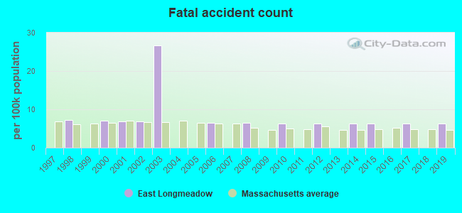
8 (See the full list of FAA Registered Aircraft in East Longmeadow)2002 - 2018 National Fire Incident Reporting System (NFIRS) incidents
- Fire incident types reported to NFIRS in East Longmeadow, MA
- 26444.8%Structure Fires
- 23940.6%Outside Fires
- 7312.4%Mobile Property/Vehicle Fires
- 132.2%Other
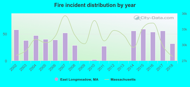 According to the data from the years 2002 - 2018 the average number of fire incidents per year is 35. The highest number of fire incidents - 59 took place in 2015, and the least - 0 in 2009. The data has a declining trend.
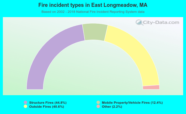 When looking into fire subcategories, the most incidents belonged to: Structure Fires (44.8%), and Outside Fires (40.6%).
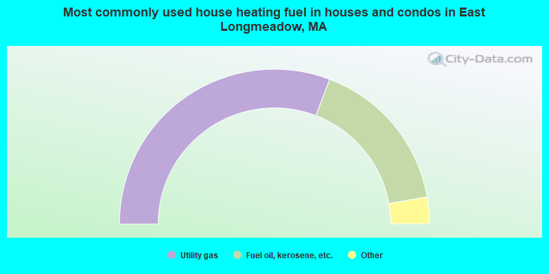
- 61.6%Utility gas
- 32.8%Fuel oil, kerosene, etc.
- 3.4%Electricity
- 1.7%Bottled, tank, or LP gas
- 0.4%Wood
- 0.2%Coal or coke
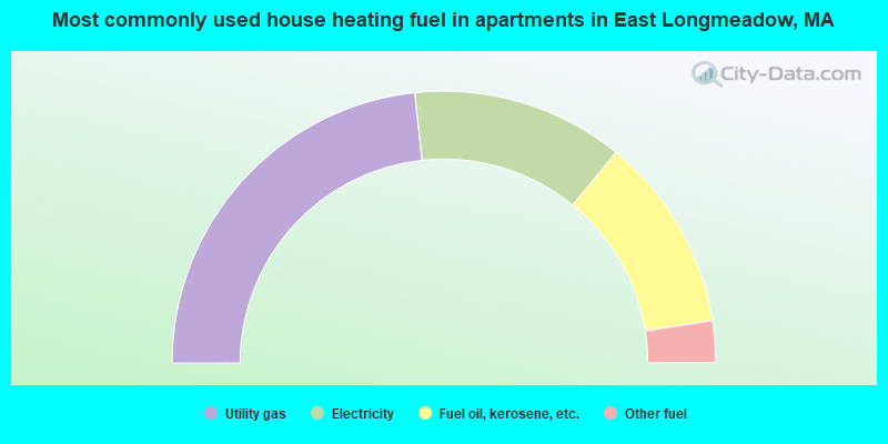
- 46.6%Utility gas
- 25.2%Electricity
- 23.2%Fuel oil, kerosene, etc.
- 5.0%Other fuel
East Longmeadow compared to Massachusetts state average:
- Unemployed percentage significantly below state average.
- Black race population percentage significantly below state average.
- Hispanic race population percentage significantly below state average.
- Median age above state average.
- Foreign-born population percentage significantly below state average.
- Renting percentage significantly below state average.
- Length of stay since moving in significantly above state average.
- Number of rooms per house significantly below state average.
- House age significantly below state average.
- Institutionalized population percentage above state average.
East Longmeadow on our top lists:
- #12 on the list of "Top 101 cities with largest percentage of males in industries: u. s. postal service (population 5,000+)"
- #14 on the list of "Top 101 cities with largest percentage of males in industries: alcoholic beverages merchant wholesalers (population 5,000+)"
- #19 on the list of "Top 101 cities with largest percentage of females in occupations: registered nurses (population 5,000+)"
- #34 on the list of "Top 101 cities with largest percentage of males in industries: paper and paper products merchant wholesalers (population 5,000+)"
- #60 on the list of "Top 101 cities with largest percentage of males in occupations: retail sales workers except cashiers (population 5,000+)"
- #68 on the list of "Top 101 cities with largest percentage of females in industries: rail transportation (population 5,000+)"
- #72 on the list of "Top 101 cities with largest percentage of males in industries: retail florists (population 5,000+)"
- #83 on the list of "Top 101 cities with largest percentage of males in occupations: communications equipment operators (population 5,000+)"
- #84 on the list of "Top 101 cities with largest percentage of males in industries: miscellaneous manufacturing (population 5,000+)"
- #89 on the list of "Top 101 cities with largest percentage of females in industries: sporting goods, camera, and hobby and toy stores (population 5,000+)"
- #97 on the list of "Top 101 cities with largest percentage of females in occupations: special education teachers (population 5,000+)"
- #99 on the list of "Top 101 cities with largest percentage of males in industries: metal and metal products (population 5,000+)"
- #100 on the list of "Top 101 cities with largest percentage of females in industries: furniture and home furnishing merchant wholesalers (population 5,000+)"
- #100 on the list of "Top 101 cities with the most people driving a car to work alone (population 5,000+)"
- #14 on the list of "Top 101 counties with the lowest percentage of residents relocating from other counties between 2010 and 2011"
- #21 on the list of "Top 101 counties with the largest number of people moving out compared to moving in (pop. 50,000+)"
- #22 on the list of "Top 101 counties with the highest carbon monoxide air pollution readings in 2012 (ppm)"
- #31 on the list of "Top 101 counties with the lowest percentage of residents relocating to other counties in 2011"
- #34 on the list of "Top 101 counties with the lowest percentage of residents that keep firearms around their homes"

|
|
Total of 147 patent applications in 2008-2024.