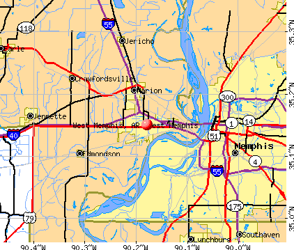
West Memphis, Arkansas

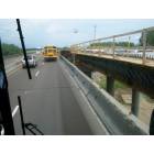
West Memphis: I-40 approaching the Mississippi River Bridge that crosses into Memphis, TN
West Memphis: Construction on I-40 driving towards Memphis
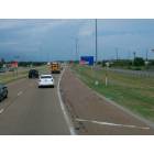
West Memphis: Interstate 40 driving towards Memphis
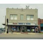
West Memphis: Crafts Music and Videos ansd Insurance
- add
your
Submit your own pictures of this city and show them to the world
- OSM Map
- General Map
- Google Map
- MSN Map
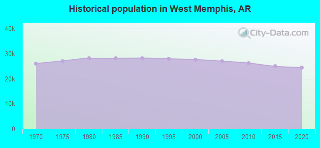
Population change since 2000: -14.0%
 |
| Males: 10,588 | |
| Females: 13,207 |
| Median resident age: | 33.7 years |
| Arkansas median age: | 38.9 years |
Zip codes: 72301.
| West Memphis: | $40,248 |
| AR: | $55,432 |
Estimated per capita income in 2022: $22,633 (it was $13,679 in 2000)
West Memphis city income, earnings, and wages data
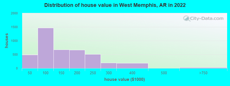
Estimated median house or condo value in 2022: $120,679 (it was $62,800 in 2000)
| West Memphis: | $120,679 |
| AR: | $179,800 |
Median gross rent in 2022: $779.
(11.1% for White Non-Hispanic residents, 32.1% for Black residents, 26.6% for Hispanic or Latino residents, 14.7% for two or more races residents)
Detailed information about poverty and poor residents in West Memphis, AR

Compare current foreclosures in West Memphis, AR:
| Photo | Address | Area | Beds / Baths | Price | Details |
|---|---|---|---|---|---|

|
#1
N Bond St
West Memphis, AR 72301
|
2,210 sq. feet
|
2 baths 3 beds |
$214,500
|
show details |

|
#2
N 18th St
West Memphis, AR 72301
|
1,312 sq. feet
|
1 baths 3 beds |
show details | |

|
#3
Purdue Ave
West Memphis, AR 72301
|
1,772 sq. feet
|
2 baths 2 beds |
show details | |

|
#4
Ashwood Dr
West Memphis, AR 72301
|
1,881 sq. feet
|
2 baths 3 beds |
show details | |

|
#5
Spears St
West Memphis, AR 72301
|
1,069 sq. feet
|
1 baths 3 beds |
show details | |

|
#6
Clement Rd
West Memphis, AR 72301
|
1,025 sq. feet
|
1 baths - beds |
show details | |

|
#7
Brentwood Dr
West Memphis, AR 72301
|
2,377 sq. feet
|
2 baths - beds |
show details | |

|
#8
S 8th St
West Memphis, AR 72301
|
1,460 sq. feet
|
1 baths - beds |
show details | |

|
#9
N 35th St
West Memphis, AR 72301
|
984 sq. feet
|
1 baths - beds |
show details | |

|
#10
S Roselawn Dr
West Memphis, AR 72301
|
2,161 sq. feet
|
2 baths - beds |
show details |
| Photo | Address | Area | Beds / Baths | Price | Details |
|---|---|---|---|---|---|

|
#11
N Rhodes St Apt 44
West Memphis, AR 72301
|
1,263 sq. feet
|
1 baths - beds |
show details | |

|
#12
Lakeview Cir
West Memphis, AR 72301
|
1,288 sq. feet
|
2 baths - beds |
show details | |

|
#13
S 15th St
West Memphis, AR 72301
|
920 sq. feet
|
1 baths - beds |
show details | |

|
#14
S 20th St
West Memphis, AR 72301
|
800 sq. feet
|
1 baths - beds |
show details | |

|
#15
N 36th St
West Memphis, AR 72301
|
1,832 sq. feet
|
1 baths - beds |
show details | |

|
#16
Arlington Dr
West Memphis, AR 72301
|
2,280 sq. feet
|
3 baths - beds |
show details | |

|
#17
Colgate Dr
West Memphis, AR 72301
|
1,587 sq. feet
|
2 baths - beds |
show details | |

|
#18
E Jackson Ave
West Memphis, AR 72301
|
672 sq. feet
|
1 baths - beds |
show details | |

|
#19
S 3rd St
West Memphis, AR 72301
|
3,127 sq. feet
|
2 baths - beds |
show details | |

|
#20
Crestmere St
West Memphis, AR 72301
|
1,878 sq. feet
|
2 baths - beds |
show details |
| Photo | Address | Area | Beds / Baths | Price | Details |
|---|---|---|---|---|---|

|
#21
W Madison Ave
West Memphis, AR 72301
|
988 sq. feet
|
1 baths - beds |
show details | |

|
#22
Belvedere Dr
West Memphis, AR 72301
|
900 sq. feet
|
1 baths - beds |
show details | |

|
#23
Magnolia Bnd
West Memphis, AR 72301
|
1,126 sq. feet
|
2 baths - beds |
show details | |

|
#24
Balfour Rd
West Memphis, AR 72301
|
1,344 sq. feet
|
2 baths - beds |
show details | |

|
#25
Westgate Cv
West Memphis, AR 72301
|
1,096 sq. feet
|
2 baths - beds |
show details | |

|
#26
Scottwood St
West Memphis, AR 72301
|
1,532 sq. feet
|
1 baths - beds |
show details | |

|
#27
S 8th St
West Memphis, AR 72301
|
1,109 sq. feet
|
1 baths - beds |
show details | |

|
#28
Hickory Cir
West Memphis, AR 72301
|
2,372 sq. feet
|
2 baths - beds |
show details | |

|
#29
N 32nd St
West Memphis, AR 72301
|
1,016 sq. feet
|
1 baths - beds |
show details | |

|
#30
Marjorie Cv
West Memphis, AR 72301
|
834 sq. feet
|
2 baths - beds |
show details |
| Photo | Address | Area | Beds / Baths | Price | Details |
|---|---|---|---|---|---|

|
#31
Dabbs Ave
West Memphis, AR 72301
|
951 sq. feet
|
2 baths - beds |
show details | |

|
#32
N 14th St
West Memphis, AR 72301
|
1,415 sq. feet
|
1 baths - beds |
show details | |

|
#33
Dover Rd
West Memphis, AR 72301
|
965 sq. feet
|
1 baths - beds |
show details | |

|
#34
Cannon Ave
West Memphis, AR 72301
|
2,044 sq. feet
|
1 baths - beds |
show details | |

|
#35
Dogwood Cv
West Memphis, AR 72301
|
874 sq. feet
|
1 baths - beds |
show details | |

|
#36
S Mcauley Dr
West Memphis, AR 72301
|
1,066 sq. feet
|
1 baths - beds |
show details | |

|
#37
N 14th St
West Memphis, AR 72301
|
1,632 sq. feet
|
1 baths - beds |
show details | |

|
#38
Dover Rd
West Memphis, AR 72301
|
1,236 sq. feet
|
1 baths - beds |
show details | |

|
#39
N Bond St
West Memphis, AR 72301
|
2,750 sq. feet
|
2 baths - beds |
show details | |

|
#40
Beatty St
West Memphis, AR 72301
|
986 sq. feet
|
1 baths - beds |
show details |
| Photo | Address | Area | Beds / Baths | Price | Details |
|---|---|---|---|---|---|

|
#41
E Barton Ave
West Memphis, AR 72301
|
1,010 sq. feet
|
1 baths - beds |
show details | |

|
#42
S 21st St
West Memphis, AR 72301
|
600 sq. feet
|
1 baths - beds |
show details | |

|
#43
S 18th St
West Memphis, AR 72301
|
696 sq. feet
|
1 baths - beds |
show details | |

|
#44
Wingate Dr
West Memphis, AR 72301
|
1,959 sq. feet
|
2 baths - beds |
show details | |

|
#45
Spears St
West Memphis, AR 72301
|
1,076 sq. feet
|
1 baths - beds |
show details | |

|
#46
Goodwin Ave
West Memphis, AR 72301
|
1,659 sq. feet
|
1 baths - beds |
show details | |

|
#47
S 8th St
West Memphis, AR 72301
|
2,695 sq. feet
|
2 baths - beds |
show details | |

|
#48
Wilson Rd
West Memphis, AR 72301
|
1,323 sq. feet
|
1 baths - beds |
show details | |

|
#49
Belehr Dr
West Memphis, AR 72301
|
1,425 sq. feet
|
1 baths - beds |
show details | |

|
Check over 1 million property listings on Foreclosure.com!
|
browse all offers | |||


- 14,53959.2%Black alone
- 7,54430.7%White alone
- 1,1404.6%Two or more races
- 5452.2%Hispanic
- 1560.6%Asian alone
- 310.1%American Indian alone
According to our research of Arkansas and other state lists, there were 93 registered sex offenders living in West Memphis, Arkansas as of April 26, 2024.
The ratio of all residents to sex offenders in West Memphis is 275 to 1.
Type |
2009 |
2010 |
2011 |
2012 |
2013 |
2014 |
2015 |
2016 |
2017 |
2018 |
2019 |
2020 |
2021 |
2022 |
|---|---|---|---|---|---|---|---|---|---|---|---|---|---|---|
| Murders (per 100,000) | 4 (14.8) | 6 (22.9) | 4 (15.1) | 6 (22.9) | 6 (23.5) | 4 (15.8) | 6 (23.8) | 14 (56.4) | 7 (27.9) | 17 (68.9) | 8 (32.7) | 7 (28.9) | 7 (29.2) | 12 (50.4) |
| Rapes (per 100,000) | 31 (114.8) | 26 (99.1) | 38 (143.7) | 31 (118.5) | 27 (105.9) | 48 (189.2) | 37 (146.7) | 52 (209.5) | 37 (147.3) | 28 (113.5) | 33 (135.0) | 31 (128.1) | 34 (141.9) | 25 (105.0) |
| Robberies (per 100,000) | 102 (377.8) | 124 (472.5) | 115 (434.9) | 137 (523.8) | 82 (321.6) | 47 (185.3) | 76 (301.4) | 80 (322.3) | 103 (409.9) | 54 (218.9) | 57 (233.2) | 45 (185.9) | 50 (208.7) | 44 (184.8) |
| Assaults (per 100,000) | 566 (2,097) | 529 (2,016) | 459 (1,736) | 483 (1,847) | 281 (1,102) | 265 (1,045) | 306 (1,213) | 317 (1,277) | 303 (1,206) | 392 (1,589) | 382 (1,563) | 526 (2,173) | 559 (2,333) | 547 (2,297) |
| Burglaries (per 100,000) | 1,077 (3,990) | 1,049 (3,997) | 1,362 (5,151) | 1,084 (4,145) | 700 (2,745) | 400 (1,577) | 366 (1,451) | 369 (1,487) | 380 (1,512) | 360 (1,459) | 336 (1,375) | 201 (830.4) | 202 (843.1) | 203 (852.6) |
| Thefts (per 100,000) | 1,049 (3,886) | 1,075 (4,096) | 1,168 (4,417) | 1,174 (4,489) | 866 (3,396) | 992 (3,910) | 921 (3,652) | 753 (3,034) | 831 (3,307) | 801 (3,247) | 760 (3,109) | 776 (3,206) | 597 (2,492) | 739 (3,104) |
| Auto thefts (per 100,000) | 146 (540.8) | 147 (560.1) | 109 (412.2) | 138 (527.7) | 104 (407.8) | 85 (335.0) | 95 (376.7) | 80 (322.3) | 102 (406.0) | 110 (445.9) | 134 (548.2) | 129 (532.9) | 166 (692.9) | 189 (793.8) |
| Arson (per 100,000) | 7 (25.9) | 17 (64.8) | 12 (45.4) | 16 (61.2) | 19 (74.5) | 9 (35.5) | 11 (43.6) | 10 (40.3) | 10 (39.8) | 7 (28.4) | 9 (36.8) | 15 (62.0) | 6 (25.0) | 8 (33.6) |
| City-Data.com crime index | 1132.2 | 1158.3 | 1193.0 | 1179.1 | 809.3 | 741.0 | 775.9 | 883.8 | 808.3 | 879.8 | 820.5 | 879.7 | 915.3 | 947.1 |
The City-Data.com crime index weighs serious crimes and violent crimes more heavily. Higher means more crime, U.S. average is 246.1. It adjusts for the number of visitors and daily workers commuting into cities.
Crime rate in West Memphis detailed stats: murders, rapes, robberies, assaults, burglaries, thefts, arson
Full-time law enforcement employees in 2021, including police officers: 86 (69 officers - 62 male; 7 female).
| Officers per 1,000 residents here: | 2.88 |
| Arkansas average: | 2.25 |
 Recent articles from our blog. Our writers, many of them Ph.D. graduates or candidates, create easy-to-read articles on a wide variety of topics.

 | Is Arkansas going to turn blue anytime soon? (452 replies) |
| Why so many Hispanics in Rogers and Springdale? (87 replies) |
| What is Jonesboro like? (9 replies) |
| Any info on Hope, AR? (3 replies) |
| Driving thru Arkansas in a few weeks (14 replies) |
| Road maintenance and passability in the Ouachitas? (16 replies) |
Latest news from West Memphis, AR collected exclusively by city-data.com from local newspapers, TV, and radio stations
Ancestries: American (10.4%), English (2.8%), Irish (2.7%), German (1.2%), African (1.1%).
Current Local Time: CST time zone
Elevation: 211 feet
Land area: 26.5 square miles.
Population density: 898 people per square mile (low).
339 residents are foreign born
| This city: | 1.4% |
| Arkansas: | 5.0% |
Median real estate property taxes paid for housing units with mortgages in 2022: $876 (0.6%)
Median real estate property taxes paid for housing units with no mortgage in 2022: $464 (0.4%)
Nearest city with pop. 50,000+: Memphis, TN  (12.0 miles , pop. 650,100).
Nearest city with pop. 1,000,000+: Dallas, TX (412.3 miles , pop. 1,188,580).
Nearest cities:
), ), ), ), ), ), Latitude: 35.15 N, Longitude: 90.18 W
Daytime population change due to commuting: +1,620 (+6.6%)
Workers who live and work in this city: 4,647 (49.7%)
Area code: 870
West Memphis, Arkansas accommodation & food services, waste management - Economy and Business Data
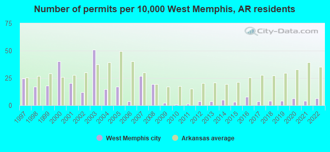
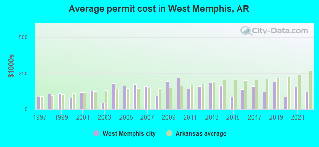
Single-family new house construction building permits:
- 2022: 18 buildings, average cost: $121,500
- 2021: 12 buildings, average cost: $157,900
- 2020: 18 buildings, average cost: $90,300
- 2019: 12 buildings, average cost: $192,100
- 2018: 12 buildings, average cost: $123,000
- 2017: 10 buildings, average cost: $161,000
- 2016: 22 buildings, average cost: $138,800
- 2015: 9 buildings, average cost: $90,000
- 2014: 14 buildings, average cost: $166,400
- 2013: 10 buildings, average cost: $184,000
- 2012: 10 buildings, average cost: $159,500
- 2011: 4 buildings, average cost: $143,300
- 2010: 3 buildings, average cost: $218,300
- 2009: 6 buildings, average cost: $195,300
- 2008: 54 buildings, average cost: $96,200
- 2007: 74 buildings, average cost: $161,100
- 2006: 10 buildings, average cost: $174,800
- 2005: 48 buildings, average cost: $163,900
- 2004: 41 buildings, average cost: $180,200
- 2003: 141 buildings, average cost: $43,800
- 2002: 33 buildings, average cost: $128,500
- 2001: 57 buildings, average cost: $118,200
- 2000: 112 buildings, average cost: $79,800
- 1999: 50 buildings, average cost: $112,000
- 1998: 47 buildings, average cost: $108,800
- 1997: 68 buildings, average cost: $87,500
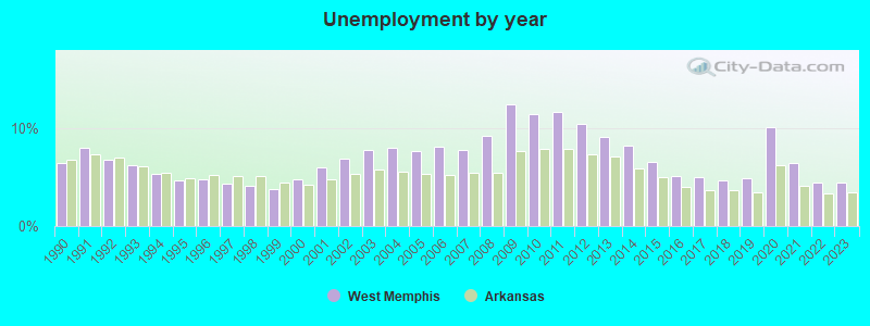
| Here: | 4.5% |
| Arkansas: | 3.4% |
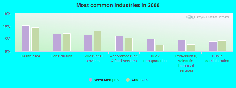
- Health care (10.3%)
- Construction (7.0%)
- Educational services (6.6%)
- Accommodation & food services (6.0%)
- Truck transportation (4.9%)
- Professional, scientific, technical services (4.7%)
- Public administration (4.0%)
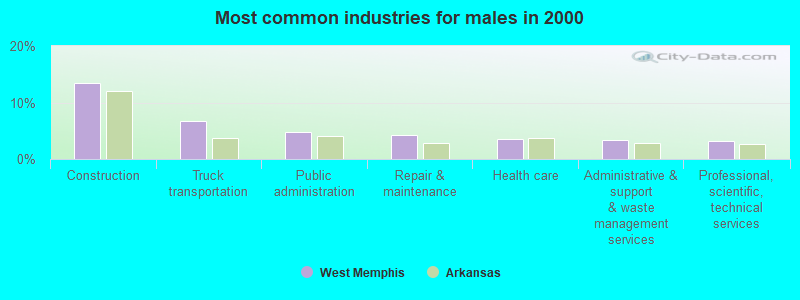
- Construction (13.4%)
- Truck transportation (6.8%)
- Public administration (4.8%)
- Repair & maintenance (4.2%)
- Health care (3.6%)
- Administrative & support & waste management services (3.3%)
- Professional, scientific, technical services (3.2%)
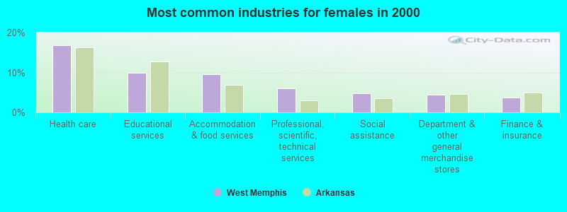
- Health care (16.8%)
- Educational services (10.0%)
- Accommodation & food services (9.5%)
- Professional, scientific, technical services (6.0%)
- Social assistance (4.9%)
- Department & other general merchandise stores (4.4%)
- Finance & insurance (3.7%)
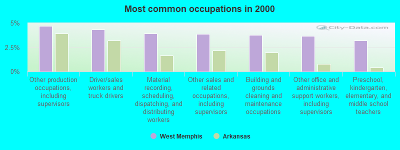
- Other production occupations, including supervisors (4.7%)
- Driver/sales workers and truck drivers (4.3%)
- Material recording, scheduling, dispatching, and distributing workers (3.9%)
- Other sales and related occupations, including supervisors (3.9%)
- Building and grounds cleaning and maintenance occupations (3.8%)
- Other office and administrative support workers, including supervisors (3.7%)
- Preschool, kindergarten, elementary, and middle school teachers (3.2%)
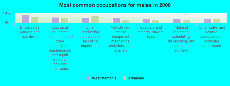
- Driver/sales workers and truck drivers (8.3%)
- Electrical equipment mechanics and other installation, maintenance, and repair workers, including supervisors (5.8%)
- Other production occupations, including supervisors (5.4%)
- Vehicle and mobile equipment mechanics, installers, and repairers (4.8%)
- Laborers and material movers, hand (4.4%)
- Material recording, scheduling, dispatching, and distributing workers (4.3%)
- Other sales and related occupations, including supervisors (4.1%)
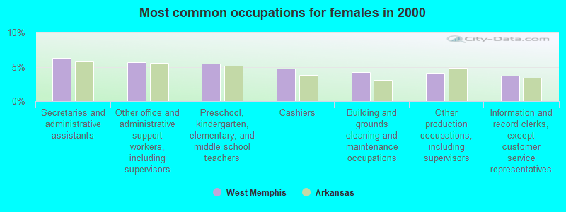
- Secretaries and administrative assistants (6.3%)
- Other office and administrative support workers, including supervisors (5.7%)
- Preschool, kindergarten, elementary, and middle school teachers (5.4%)
- Cashiers (4.7%)
- Building and grounds cleaning and maintenance occupations (4.3%)
- Other production occupations, including supervisors (4.0%)
- Information and record clerks, except customer service representatives (3.7%)
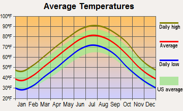
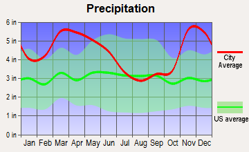
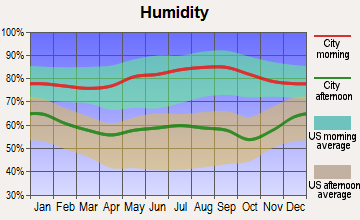
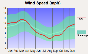
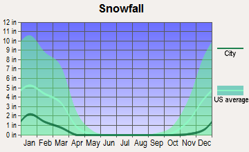
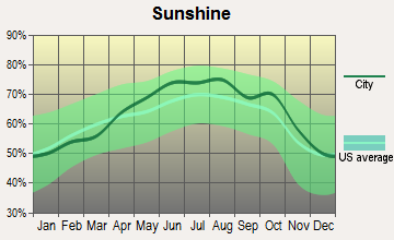
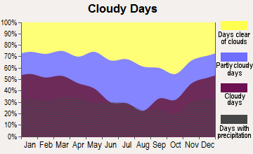
Average climate in West Memphis, Arkansas
Based on data reported by over 4,000 weather stations
|
|

(lower is better)
Air Quality Index (AQI) level in 2023 was 74.6. This is about average.
| City: | 74.6 |
| U.S.: | 72.6 |
Carbon Monoxide (CO) [ppm] level in 2022 was 0.257. This is about average. Closest monitor was 7.6 miles away from the city center.
| City: | 0.257 |
| U.S.: | 0.251 |
Nitrogen Dioxide (NO2) [ppb] level in 2023 was 7.98. This is significantly worse than average. Closest monitor was 0.2 miles away from the city center.
| City: | 7.98 |
| U.S.: | 5.11 |
Sulfur Dioxide (SO2) [ppb] level in 2022 was 0.365. This is significantly better than average. Closest monitor was 0.2 miles away from the city center.
| City: | 0.365 |
| U.S.: | 1.515 |
Ozone [ppb] level in 2023 was 31.0. This is about average. Closest monitor was 3.3 miles away from the city center.
| City: | 31.0 |
| U.S.: | 33.3 |
Particulate Matter (PM10) [µg/m3] level in 2022 was 20.4. This is about average. Closest monitor was 0.2 miles away from the city center.
| City: | 20.4 |
| U.S.: | 19.2 |
Particulate Matter (PM2.5) [µg/m3] level in 2022 was 8.75. This is about average. Closest monitor was 0.2 miles away from the city center.
| City: | 8.75 |
| U.S.: | 8.11 |
Tornado activity:
West Memphis-area historical tornado activity is near Arkansas state average. It is 102% greater than the overall U.S. average.
On 4/21/1984, a category F3 (max. wind speeds 158-206 mph) tornado 2.2 miles away from the West Memphis city center injured 3 people and caused between $500,000 and $5,000,000 in damages.
On 12/14/1987, a category F3 tornado 4.5 miles away from the city center killed 6 people and injured 121 people and caused between $5,000,000 and $50,000,000 in damages.
Earthquake activity:
West Memphis-area historical earthquake activity is significantly above Arkansas state average. It is 387% greater than the overall U.S. average.On 3/25/1976 at 00:41:20, a magnitude 5.0 (4.9 MB, 5.0 LG, Class: Moderate, Intensity: VI - VII) earthquake occurred 34.7 miles away from the city center
On 5/4/1991 at 01:18:54, a magnitude 5.0 (4.4 MB, 4.6 LG, 5.0 LG, Depth: 3.1 mi) earthquake occurred 99.8 miles away from West Memphis center
On 4/27/1989 at 16:47:49, a magnitude 4.7 (4.6 MB, 4.7 LG, 4.3 LG, Class: Light, Intensity: IV - V) earthquake occurred 63.5 miles away from the city center
On 3/25/1976 at 01:00:11, a magnitude 4.5 (4.1 MB, 4.5 LG) earthquake occurred 36.0 miles away from West Memphis center
On 9/26/1990 at 13:18:51, a magnitude 5.0 (4.7 MB, 4.8 LG, 5.0 LG, Depth: 7.7 mi) earthquake occurred 144.0 miles away from the city center
On 5/4/2001 at 06:42:12, a magnitude 4.7 (4.2 MB, 4.7 LG, 4.5 LG) earthquake occurred 114.0 miles away from West Memphis center
Magnitude types: regional Lg-wave magnitude (LG), body-wave magnitude (MB)
Natural disasters:
The number of natural disasters in Crittenden County (15) is near the US average (15).Major Disasters (Presidential) Declared: 11
Emergencies Declared: 3
Causes of natural disasters: Storms: 9, Floods: 7, Tornadoes: 5, Winter Storms: 4, Hurricane: 1, Ice Storm: 1, Other: 1 (Note: some incidents may be assigned to more than one category).
Hospitals and medical centers in West Memphis:
- ARKANSAS DEPARTMENT OF HEALTH HOSPICE 9E (CRITTENDEN COUNTY HU 901 NORTH 7TH)
- CRITTENDEN MEMORIAL HOSPITAL (Voluntary non-profit - Private, provides emergency services, 200 TYLER)
- HAVEN HOSPICE SERVICES (308 SOUTH RHODES)
- BROADWAY HEALTHCARE CENTER (800 WEST BROADWAY)
- GERIATRIC NURSING CENTER (610 S AVALON)
- HEALTH CARE AND REHABILITATION CENTER OF WEST MEMP (610 SOUTH AVALON ST)
- LEISURE LODGE INC (111 E JACKSON)
- FMCNA - EAST ARKANSAS (310 S RHODES)
- CRITTENDEN COUNTY HEALTH UNIT (901 NORTH SEVENTH STREET)
- CRITTENDEN REG HOSPITAL HOME HEALTH W MEMPHIS (200 TYLER CMH PAVILLION STE 1)
Airports and heliports located in West Memphis:
- West Memphis Municipal Airport (AWM) (Runways: 1, Itinerant Ops: 43,000, Local Ops: 7,000, Military Ops: 200)
- Crittenden Regional Hospital Heliport (08AR)
Amtrak station near West Memphis:
College/University in West Memphis:
Colleges/universities with over 2000 students nearest to West Memphis:
- Southwest Tennessee Community College (about 9 miles; Memphis, TN; Full-time enrollment: 8,043)
- Rhodes College (about 11 miles; Memphis, TN; FT enrollment: 2,052)
- University of Memphis (about 12 miles; Memphis, TN; FT enrollment: 17,427)
- Northwest Mississippi Community College (about 39 miles; Senatobia, MS; FT enrollment: 6,607)
- Arkansas State University-Main Campus (about 56 miles; Jonesboro, AR; FT enrollment: 12,323)
- University of Mississippi (about 66 miles; University, MS; FT enrollment: 17,642)
- Coahoma Community College (about 66 miles; Clarksdale, MS; FT enrollment: 2,284)
Public high schools in West Memphis:
- MID-SOUTH COMM COLLEGE TECH CENTER (Location: 2000 W BRDWAY, Grades: 9-12)
- EAST JUNIOR HIGH SCHOOL (Location: 1151 GOODWIN ST, Grades: 7-9)
- WEST JUNIOR HIGH SCHOOL (Location: 331 W BARTON ST, Grades: 7-9)
- WONDER JUNIOR HIGH SCHOOL (Location: 1401 MADISON ST, Grades: 7-9)
- THE ACADEMIES OF WEST MEMPHIS CHARTER SCHOOL (Location: 501 BROADWAY, Grades: 10-12, Charter school)
Private high school in West Memphis:
Public elementary/middle schools in West Memphis:
- BRAGG ELEMENTARY SCHOOL (Location: 309 W BARTON, Grades: KG-6)
- FAULK ELEMENTARY SCHOOL (Location: 908 VANDERBILT, Grades: KG-6)
- JACKSON ELEMENTARY SCHOOL (Location: 2395 SL HENRY ST, Grades: KG-6)
- MADDUX ELEMENTARY SCHOOL (Location: 2100 E BARTON, Grades: KG-6)
- RICHLAND ELEMENTARY SCHOOL (Location: 1011 W BARTON, Grades: KG-6)
- WEAVER ELEMENTARY SCHOOL (Location: 1280 E BARTON, Grades: KG-6)
- WONDER ELEMENTARY SCHOOL (Location: 801 S 16TH ST, Grades: PK-6)
- AVONDALE ELEMENTARY SCHOOL (Location: 1402 CRESTMERE, Grades: PK-1)
Private elementary/middle school in West Memphis:
Points of interest:
Notable locations in West Memphis: Wimef (A), Meadowbrook Country Club (B), Riverside Speedway (C), Southland Park Racetrack (D), Airport Industrial Park (E), Interstate Industrial Park (F), Missouri Pacific Industrial Park (G), Rainer Industrial Park (H), Wilson-Rich Industrial Park (I), Eugene Woods Community Center (J), West Memphis City Hall (K), West Memphis Fire Department Station 1 (L), West Memphis Fire Department Station 2 (M), West Memphis Fire Department Station 3 (N), West Memphis Fire Department Station 4 (O), West Memphis Police Department (P), Federal Bureau of Investigation West Memphis Resident Office (Q), Crittenden County Drug Task Force (R), Crittenden County Sheriff's Office (S), Crittenden Emergency Medical Service (T). Display/hide their locations on the map
Shopping Centers: Broadway Plaza East Shopping Center (1), Holiday Plaza Mall Shopping Center (2), Missouri Avenue Plaza Shopping Center (3). Display/hide their locations on the map
Churches in West Memphis include: Morning Star Church (A), Westwood Church (B), Mount Harmon Church (C), Saint Pauls Church (D), Williams Chapel Church (E), Whole Bible Church of Jesus Christ (F), Westwood Acres Church of Christ (G), Westminster Presbyterian Church (H), Victory Fellowship Church (I). Display/hide their locations on the map
Streams, rivers, and creeks: Garant Bayou (A). Display/hide its location on the map
Parks in West Memphis include: Worthington Park (1), Avondale Park (2), Franklin Park (3), Hicks Park (4), Hightower Park (5), Horton Park (6), Matthews Park (7), Rowe Park (8), Tenth Street Mini-Park (9). Display/hide their locations on the map
Tourist attractions: Arkansas State - State Government Toll Free Numbers- Tourist Informa (4 Highway I 40) (1), Cj's Pool Hall (Arcades & Amusements; 1621 East Broadway Street) (2). Display/hide their approximate locations on the map
Hotels: West Memphis Inn (923 E Broadway St) (1), Budget Inn (4361 East Broadway Street) (2), Relax Inn (2407 South Service Road) (3), Super 8 West Memphis AR (901 Martin Luther King Jr Boulevard) (4), Ramada Inn Limited (210 South Service Road) (5), Twentieth Century Motel (1901 East Broadway Street) (6), Comfort Inn West Memphis (1300 Ingram Boulevard) (7), West Memphis Super 8 Motel (901 Martin Luther King Jr. Blvd I-40 Exit 280 Club Road Or I-5) (8), Sunset Inn (300 Martin Luther King D) (9). Display/hide their approximate locations on the map
Courts: Federal Bureau of Investigation (310 West Service Road) (1), Arkansas-State - Community Punishment-Department- Drug Court Color Of The- Arkansas Highway Po (250 Shoppingway Boulevard) (2). Display/hide their approximate locations on the map
Birthplace of: Marcus Brown - Basketball player, Corey L. Brewer - Basketball player, Michael Cage - Basketball player, Shirley Brown - Singer, Sonny Weems - Basketball player, T. J. Holmes - Journalist, Keith Lee - Basketball player, Tom Watkins (American football) - Football player, Betty Blue (model) - Actor, Charles Stackhouse - Football player.
| This city: | 2.6 people |
| Arkansas: | 2.5 people |
| This city: | 67.5% |
| Whole state: | 67.6% |
| This city: | 7.0% |
| Whole state: | 5.7% |
Likely homosexual households (counted as self-reported same-sex unmarried-partner households)
- Lesbian couples: 0.4% of all households
- Gay men: 0.3% of all households
People in group quarters in West Memphis in 2010:
- 299 people in local jails and other municipal confinement facilities
- 206 people in nursing facilities/skilled-nursing facilities
- 60 people in group homes intended for adults
- 31 people in emergency and transitional shelters (with sleeping facilities) for people experiencing homelessness
- 12 people in workers' group living quarters and job corps centers
People in group quarters in West Memphis in 2000:
- 251 people in local jails and other confinement facilities (including police lockups)
- 211 people in nursing homes
- 35 people in homes for the mentally retarded
- 17 people in other noninstitutional group quarters
Banks with branches in West Memphis (2011 data):
- Regions Bank: Shoppingway Branch at 214 Shoppingway Boulevard, branch established on 1985/02/15; West Memphis Main Office Branch at 231 East Broadway, branch established on 1941/09/15. Info updated 2011/02/24: Bank assets: $123,368.2 mil, Deposits: $98,301.3 mil, headquarters in Birmingham, AL, positive income, Commercial Lending Specialization, 1778 total offices, Holding Company: Regions Financial Corporation
- SunTrust Bank: West Memphis Civic Center 954 at 125 West Broadway, branch established on 1986/12/05; W. Memphis Walmart 953 at 798 West Service Road, branch established on 1995/02/25. Info updated 2010/05/27: Bank assets: $171,291.7 mil, Deposits: $129,833.2 mil, headquarters in Atlanta, GA, positive income, Commercial Lending Specialization, 1716 total offices, Holding Company: Suntrust Banks, Inc.
- Fidelity National Bank: Mid-Continent Branch at 350 West Service Road, branch established on 1974/07/31; at 330 West Broadway, branch established on 1966/11/04. Info updated 2006/11/03: Bank assets: $332.5 mil, Deposits: $293.6 mil, local headquarters, positive income, 5 total offices, Holding Company: Carlson Bancshares, Inc.
- Evolve Bank & Trust: at 301 Shoppingway Boulevard, branch established on 1925/06/05. Info updated 2010/09/22: Bank assets: $246.3 mil, Deposits: $159.6 mil, local headquarters, positive income, Mortgage Lending Specialization, 22 total offices, Holding Company: Evolve Financial Group, Inc.
- First Community Bank of Eastern Arkansas: Missouri Street Branch at 1103 North Missouri Street, branch established on 2005/05/20. Info updated 2006/11/03: Bank assets: $115.5 mil, Deposits: $101.2 mil, headquarters in Marion, AR, positive income, Commercial Lending Specialization, 2 total offices, Holding Company: Fcb Financial Services, Inc
For population 15 years and over in West Memphis:
- Never married: 40.6%
- Now married: 32.8%
- Separated: 3.6%
- Widowed: 7.9%
- Divorced: 15.1%
For population 25 years and over in West Memphis:
- High school or higher: 83.7%
- Bachelor's degree or higher: 14.6%
- Graduate or professional degree: 3.1%
- Unemployed: 8.1%
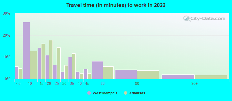
- Mean travel time to work (commute): 18.5 minutes
| Here: | 10.1 |
| Arkansas average: | 11.4 |
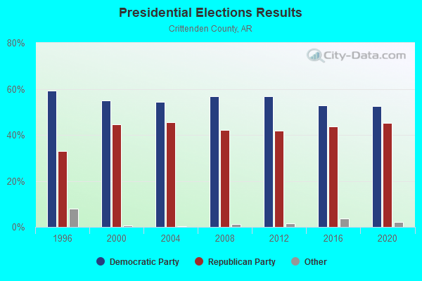
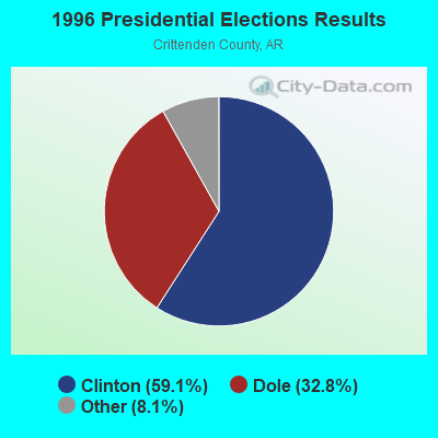
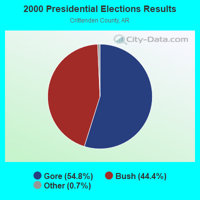
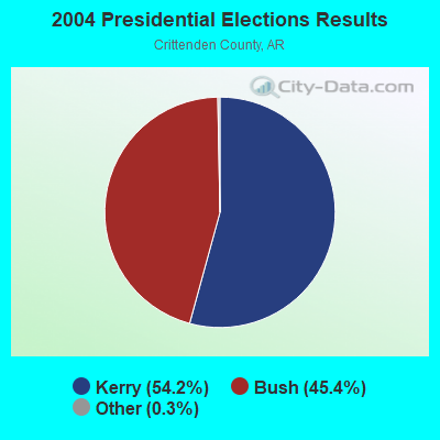
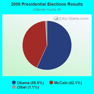


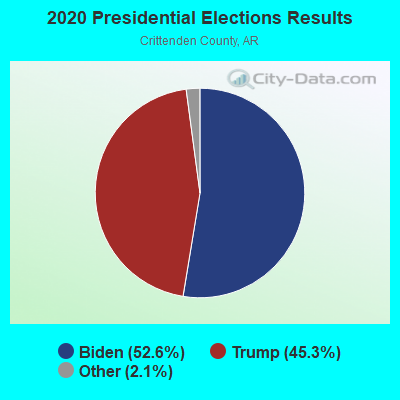
Graphs represent county-level data. Detailed 2008 Election Results
Religion statistics for West Memphis, AR (based on Crittenden County data)
| Religion | Adherents | Congregations |
|---|---|---|
| Evangelical Protestant | 16,649 | 48 |
| Black Protestant | 4,466 | 17 |
| Mainline Protestant | 2,805 | 8 |
| Catholic | 525 | 3 |
| Other | 411 | 3 |
| None | 26,046 | - |
Food Environment Statistics:
| Crittenden County: | 2.69 / 10,000 pop. |
| Arkansas: | 2.02 / 10,000 pop. |
| Here: | 0.19 / 10,000 pop. |
| Arkansas: | 0.25 / 10,000 pop. |
| Crittenden County: | 0.19 / 10,000 pop. |
| Arkansas: | 0.59 / 10,000 pop. |
| Here: | 4.80 / 10,000 pop. |
| State: | 4.94 / 10,000 pop. |
| This county: | 2.88 / 10,000 pop. |
| Arkansas: | 6.66 / 10,000 pop. |
| Crittenden County: | 12.7% |
| Arkansas: | 9.8% |
| This county: | 34.2% |
| Arkansas: | 29.1% |
| Crittenden County: | 13.9% |
| Arkansas: | 13.6% |
Health and Nutrition:
| Here: | 46.8% |
| Arkansas: | 48.2% |
| Here: | 42.9% |
| Arkansas: | 44.2% |
| West Memphis: | 29.8 |
| State: | 28.9 |
| This city: | 21.9% |
| Arkansas: | 21.6% |
| This city: | 12.8% |
| Arkansas: | 11.3% |
| West Memphis: | 6.7 |
| State: | 6.8 |
| Here: | 35.6% |
| Arkansas: | 34.0% |
| West Memphis: | 52.7% |
| Arkansas: | 54.4% |
| Here: | 80.2% |
| Arkansas: | 78.0% |
More about Health and Nutrition of West Memphis, AR Residents
| Local government employment and payroll (March 2022) | |||||
| Function | Full-time employees | Monthly full-time payroll | Average yearly full-time wage | Part-time employees | Monthly part-time payroll |
|---|---|---|---|---|---|
| Police Protection - Officers | 90 | $418,122 | $55,750 | 0 | $0 |
| Firefighters | 60 | $299,646 | $59,929 | 0 | $0 |
| Solid Waste Management | 30 | $81,323 | $32,529 | 0 | $0 |
| Streets and Highways | 28 | $95,010 | $40,719 | 0 | $0 |
| Financial Administration | 21 | $95,244 | $54,425 | 1 | $1,831 |
| Electric Power | 21 | $114,273 | $65,299 | 0 | $0 |
| Police - Other | 17 | $51,947 | $36,668 | 11 | $5,364 |
| Other and Unallocable | 13 | $65,718 | $60,663 | 5 | $5,867 |
| Parks and Recreation | 13 | $49,940 | $46,098 | 1 | $1,018 |
| Judicial and Legal | 11 | $48,948 | $53,398 | 0 | $0 |
| Water Supply | 10 | $54,635 | $65,562 | 0 | $0 |
| Housing and Community Development (Local) | 10 | $48,353 | $58,024 | 0 | $0 |
| Airports | 7 | $24,443 | $41,902 | 0 | $0 |
| Sewerage | 6 | $30,981 | $61,962 | 0 | $0 |
| Other Government Administration | 5 | $22,775 | $54,660 | 25 | $11,669 |
| Local Libraries | 4 | $13,091 | $39,273 | 6 | $5,495 |
| Fire - Other | 3 | $7,904 | $31,616 | 0 | $0 |
| Totals for Government | 349 | $1,522,353 | $52,345 | 49 | $31,244 |
West Memphis government finances - Expenditure in 2021 (per resident):
- Construction - Sewerage: $3,635,000 ($152.76)
Libraries: $3,484,000 ($146.42)
Electric Utilities: $668,000 ($28.07)
Water Utilities: $532,000 ($22.36)
Regular Highways: $531,000 ($22.32)
Air Transportation: $240,000 ($10.09)
- Current Operations - Electric Utilities: $21,263,000 ($893.59)
Police Protection: $8,769,000 ($368.52)
Local Fire Protection: $5,690,000 ($239.13)
Regular Highways: $3,463,000 ($145.53)
Solid Waste Management: $2,536,000 ($106.58)
General - Other: $2,303,000 ($96.79)
Sewerage: $1,962,000 ($82.45)
Water Utilities: $1,504,000 ($63.21)
Central Staff Services: $1,322,000 ($55.56)
Air Transportation: $1,217,000 ($51.15)
Judicial and Legal Services: $861,000 ($36.18)
Financial Administration: $708,000 ($29.75)
Parks and Recreation: $672,000 ($28.24)
Health - Other: $614,000 ($25.80)
Libraries: $599,000 ($25.17)
Housing and Community Development: $347,000 ($14.58)
Sea and Inland Port Facilities: $55,000 ($2.31)
- General - Interest on Debt: $227,000 ($9.54)
- Other Capital Outlay - Local Fire Protection: $167,000 ($7.02)
General - Other: $87,000 ($3.66)
Judicial and Legal Services: $68,000 ($2.86)
Parks and Recreation: $62,000 ($2.61)
Air Transportation: $13,000 ($0.55)
Police Protection: $8,000 ($0.34)
Financial Administration: $1,000 ($0.04)
West Memphis government finances - Revenue in 2021 (per resident):
- Charges - Solid Waste Management: $2,553,000 ($107.29)
Sewerage: $1,397,000 ($58.71)
Air Transportation: $1,252,000 ($52.62)
Other: $673,000 ($28.28)
Sea and Inland Port Facilities: $276,000 ($11.60)
Parks and Recreation: $2,000 ($0.08)
- Federal Intergovernmental - Health and Hospitals: $1,047,000 ($44.00)
Highways: $570,000 ($23.95)
Housing and Community Development: $376,000 ($15.80)
Other: $374,000 ($15.72)
Air Transportation: $69,000 ($2.90)
- Local Intergovernmental - General Local Government Support: $2,378,000 ($99.94)
- Miscellaneous - General Revenue - Other: $1,759,000 ($73.92)
Fines and Forfeits: $997,000 ($41.90)
Interest Earnings: $301,000 ($12.65)
Rents: $62,000 ($2.61)
Donations From Private Sources: $37,000 ($1.55)
- Revenue - Electric Utilities: $23,571,000 ($990.59)
Water Utilities: $1,351,000 ($56.78)
- State Intergovernmental - Highways: $1,981,000 ($83.25)
General Local Government Support: $401,000 ($16.85)
Other: $52,000 ($2.19)
- Tax - General Sales and Gross Receipts: $7,656,000 ($321.75)
Pari - mutuels Sales: $6,108,000 ($256.69)
Public Utilities Sales: $2,244,000 ($94.31)
Other Selective Sales: $1,413,000 ($59.38)
Property: $1,399,000 ($58.79)
Occupation and Business License - Other: $308,000 ($12.94)
Other License: $114,000 ($4.79)
Alcoholic Beverage Sales: $67,000 ($2.82)
West Memphis government finances - Debt in 2021 (per resident):
- Long Term Debt - Outstanding Unspecified Public Purpose: $3,081,000 ($129.48)
Beginning Outstanding - Public Debt for Private Purpose: $2,900,000 ($121.87)
Beginning Outstanding - Unspecified Public Purpose: $2,893,000 ($121.58)
Outstanding Nonguaranteed - Industrial Revenue: $1,500,000 ($63.04)
Retired Nonguaranteed - Public Debt for Private Purpose: $1,400,000 ($58.84)
Issue, Unspecified Public Purpose: $467,000 ($19.63)
Retired Unspecified Public Purpose: $279,000 ($11.73)
West Memphis government finances - Cash and Securities in 2021 (per resident):
- Bond Funds - Cash and Securities: $959,000 ($40.30)
- Other Funds - Cash and Securities: $47,677,000 ($2003.66)
- Sinking Funds - Cash and Securities: $1,811,000 ($76.11)
| Businesses in West Memphis, AR | ||||
| Name | Count | Name | Count | |
|---|---|---|---|---|
| AT&T | 1 | Little Caesars Pizza | 1 | |
| Advance Auto Parts | 1 | MasterBrand Cabinets | 2 | |
| Applebee's | 1 | McDonald's | 3 | |
| Baskin-Robbins | 1 | Motel 6 | 1 | |
| Best Western | 1 | Nike | 2 | |
| Blockbuster | 1 | Papa John's Pizza | 1 | |
| Burger King | 2 | Payless | 1 | |
| Comfort Suites | 1 | Pizza Hut | 1 | |
| Cricket Wireless | 2 | Popeyes | 1 | |
| Dairy Queen | 1 | Quality | 1 | |
| Days Inn | 1 | RadioShack | 1 | |
| Decora Cabinetry | 1 | Ramada | 1 | |
| Dennys | 1 | Red Roof Inn | 1 | |
| Domino's Pizza | 1 | SONIC Drive-In | 1 | |
| Econo Lodge | 1 | Sears | 1 | |
| FedEx | 10 | Subway | 4 | |
| Ford | 1 | Super 8 | 1 | |
| H&R Block | 1 | T-Mobile | 2 | |
| Holiday Inn | 1 | Taco Bell | 2 | |
| Howard Johnson | 1 | U-Haul | 2 | |
| Jones New York | 1 | UPS | 6 | |
| KFC | 2 | Waffle House | 1 | |
| Kroger | 1 | Walgreens | 2 | |
| La-Z-Boy | 1 | Walmart | 1 | |
Strongest AM radio stations in West Memphis:
- WDIA (1070 AM; 50 kW; MEMPHIS, TN; Owner: CLEAR CHANNEL BROADCASTING LICENSES, INC.)
- WGSF (1030 AM; 50 kW; MEMPHIS, TN; Owner: FLINN BROADCASTING CORPORATION)
- KSUD (730 AM; 1 kW; WEST MEMPHIS, AR; Owner: EDUCATIONAL MEDIA FOUNDATION)
- WCRV (640 AM; 50 kW; COLLIERVILLE, TN; Owner: BOTT BROADCASTING COMPANY/TENNESSEE)
- WJCE (680 AM; 10 kW; MEMPHIS, TN; Owner: ENTERCOM MEMPHIS LICENSE, LLC)
- KWAM (990 AM; 10 kW; MEMPHIS, TN; Owner: CONCORD MEDIA GROUP, INC.)
- WHBQ (560 AM; 5 kW; MEMPHIS, TN; Owner: FLINN BROADCASTING CORPORATION)
- WREC (600 AM; 5 kW; MEMPHIS, TN; Owner: CLEAR CHANNEL BROADCASTING LICENSES, INC.)
- WMQM (1600 AM; 50 kW; LAKELAND, TN; Owner: WMQM, INC.)
- WBBP (1480 AM; 5 kW; MEMPHIS, TN)
- WMC (790 AM; 5 kW; MEMPHIS, TN; Owner: INFINITY RADIO OPERATIONS INC.)
- WLOK (1340 AM; 1 kW; MEMPHIS, TN; Owner: WLOK RADIO, INC.)
- WPLX (1170 AM; 10 kW; GERMANTOWN, TN; Owner: EDUCATIONAL MEDIA FOUNDATION)
Strongest FM radio stations in West Memphis:
- KJMS (101.1 FM; MEMPHIS, TN; Owner: CLEAR CHANNEL BROADCASTING LICENSES, INC.)
- KXHT (107.1 FM; MARION, AR; Owner: FLINN BROADCASTING CORPORATION)
- WHRK (97.1 FM; MEMPHIS, TN; Owner: CLEAR CHANNEL BROADCASTING LICENSES, INC.)
- WSRR-FM (98.1 FM; MILLINGTON, TN; Owner: KOOL BROADCASTING, INC.)
- WMC-FM (99.7 FM; MEMPHIS, TN; Owner: INFINITY RADIO OPERATIONS INC.)
- WYPL (89.3 FM; MEMPHIS, TN; Owner: MEMPHIS/SHELBY COUNTY PUBLIC LIBRARY & INFO CNTR.)
- WGKX (105.9 FM; MEMPHIS, TN; Owner: KIX BROADCASTING, INC.)
- WRVR-FM (104.5 FM; MEMPHIS, TN; Owner: ENTERCOM MEMPHIS LICENSE, LLC)
- WEGR (102.7 FM; MEMPHIS, TN; Owner: CLEAR CHANNEL BROADCASTING LICENSES, INC.)
- WHAL-FM (95.7 FM; OLIVE BRANCH, MS; Owner: CLEAR CHANNEL BROADCASTING LICENSES, INC.)
- WKNO-FM (91.1 FM; MEMPHIS, TN; Owner: MID-SOUTH PUBLIC COMMUNICATIONS FOUNDATION)
- KKLV (94.7 FM; TURRELL, AR; Owner: EDUCATIONAL MEDIA FOUNDATION)
- WUMR (91.7 FM; MEMPHIS, TN; Owner: THE UNIVERSITY OF MEMPHIS)
- WMBZ (94.1 FM; GERMANTOWN, TN; Owner: ENTERCOM MEMPHIS LICENSE, LLC)
- WQOX (88.5 FM; MEMPHIS, TN; Owner: MEMPHIS CITY SCHOOLS)
- WMFS (92.9 FM; BARTLETT, TN; Owner: INFINITY BROADCASTING CORP. OF ILLINOIS)
- WEVL (89.9 FM; MEMPHIS, TN; Owner: SOUTHERN COMMUNICATION VOLUNTEERS, INC.)
- WMPS (107.5 FM; GERMANTOWN, TN; Owner: FLINN BROADCASTING CORPORATION)
- KTRQ (102.3 FM; COLT, AR; Owner: EAST ARKANSAS BROADCASTERS, INC.)
- WVIM-FM (95.3 FM; COLDWATER, MS; Owner: DESOTO COUNTY B/CING. CO.)
TV broadcast stations around West Memphis:
- WBXP-CA (Channel 44; MEMPHIS, TN; Owner: THE BOX WORLDWIDE LLC)
- W42BY (Channel 42; MEMPHIS, TN; Owner: THREE ANGELS BROADCASTING NETWORK, INC,)
- W67CV (Channel 67; MEMPHIS, TN; Owner: GEORGE S. FLINN, JR.)
- WREG-TV (Channel 3; MEMPHIS, TN; Owner: NEW YORK TIMES MANAGEMENT SERVICES)
- WMC-TV (Channel 5; MEMPHIS, TN; Owner: RAYCOM AMERICA, INC.)
- WHBQ-TV (Channel 13; MEMPHIS, TN; Owner: FOX TELEVISION STATIONS, INC.)
- WKNO (Channel 10; MEMPHIS, TN; Owner: MID-SOUTH PUBLIC COMMUNICATIONS FOUNDATION)
- WPXX-TV (Channel 50; MEMPHIS, TN; Owner: FLINN BROADCASTING CORPORATION)
- WJRJ-LP (Channel 59; MEMPHIS, TN; Owner: WORD OF GOD FELLOWSHIP, INC.)
- WLMT (Channel 30; MEMPHIS, TN; Owner: CLEAR CHANNEL BROADCASTING LICENSES, INC.)
- WPTY-TV (Channel 24; MEMPHIS, TN; Owner: CLEAR CHANNEL BROADCASTING LICENSES, INC.)
- W57CG (Channel 57; MEMPHIS, TN; Owner: GEORGE S. FLINN, JR.)
- W61BP (Channel 61; MEMPHIS, TN; Owner: JIMMY BOYD)
- KVTJ (Channel 48; JONESBORO, AR; Owner: AGAPE CHURCH, INC.)
- WBUY (Channel 40; HOLLY SPRINGS, MS; Owner: TRINITY BROADCASTING NETWORK)
- National Bridge Inventory (NBI) Statistics
- 135Number of bridges
- 2,470ft / 753mTotal length
- $14,409,000Total costs
- 1,888,788Total average daily traffic
- 284,656Total average daily truck traffic
- New bridges - historical statistics
- 21920-1929
- 11940-1949
- 91950-1959
- 171960-1969
- 41970-1979
- 151980-1989
- 101990-1999
- 202000-2009
- 72010-2019
FCC Registered Antenna Towers: 203 (See the full list of FCC Registered Antenna Towers)
FCC Registered Private Land Mobile Towers: 5 (See the full list of FCC Registered Private Land Mobile Towers in West Memphis, AR)
FCC Registered Broadcast Land Mobile Towers: 33 (See the full list of FCC Registered Broadcast Land Mobile Towers)
FCC Registered Microwave Towers: 33 (See the full list of FCC Registered Microwave Towers in this town)
FCC Registered Paging Towers: 3 (See the full list of FCC Registered Paging Towers)
FCC Registered Maritime Coast & Aviation Ground Towers: 3 (See the full list of FCC Registered Maritime Coast & Aviation Ground Towers)
FCC Registered Amateur Radio Licenses: 67 (See the full list of FCC Registered Amateur Radio Licenses in West Memphis)
FAA Registered Aircraft Manufacturers and Dealers: 2 (See the full list of FAA Registered Manufacturers and Dealers in West Memphis)
FAA Registered Aircraft: 32 (See the full list of FAA Registered Aircraft)
| Home Mortgage Disclosure Act Aggregated Statistics For Year 2009 (Based on 8 full and 3 partial tracts) | ||||||||||||||
| A) FHA, FSA/RHS & VA Home Purchase Loans | B) Conventional Home Purchase Loans | C) Refinancings | D) Home Improvement Loans | E) Loans on Dwellings For 5+ Families | F) Non-occupant Loans on < 5 Family Dwellings (A B C & D) | G) Loans On Manufactured Home Dwelling (A B C & D) | ||||||||
|---|---|---|---|---|---|---|---|---|---|---|---|---|---|---|
| Number | Average Value | Number | Average Value | Number | Average Value | Number | Average Value | Number | Average Value | Number | Average Value | Number | Average Value | |
| LOANS ORIGINATED | 137 | $106,039 | 61 | $75,566 | 141 | $110,225 | 31 | $11,270 | 2 | $4,052,540 | 59 | $48,871 | 0 | $0 |
| APPLICATIONS APPROVED, NOT ACCEPTED | 4 | $95,722 | 5 | $91,230 | 11 | $131,495 | 3 | $13,757 | 0 | $0 | 0 | $0 | 1 | $31,820 |
| APPLICATIONS DENIED | 8 | $137,570 | 13 | $69,376 | 96 | $109,661 | 27 | $16,147 | 0 | $0 | 12 | $92,931 | 5 | $50,164 |
| APPLICATIONS WITHDRAWN | 8 | $93,994 | 4 | $113,088 | 64 | $102,782 | 4 | $41,155 | 0 | $0 | 4 | $110,352 | 0 | $0 |
| FILES CLOSED FOR INCOMPLETENESS | 3 | $92,773 | 0 | $0 | 9 | $108,788 | 0 | $0 | 0 | $0 | 0 | $0 | 0 | $0 |
Detailed mortgage data for all 12 tracts in West Memphis, AR
| Private Mortgage Insurance Companies Aggregated Statistics For Year 2009 (Based on 3 full and 3 partial tracts) | ||||
| A) Conventional Home Purchase Loans | B) Refinancings | |||
|---|---|---|---|---|
| Number | Average Value | Number | Average Value | |
| LOANS ORIGINATED | 6 | $149,527 | 7 | $174,150 |
| APPLICATIONS APPROVED, NOT ACCEPTED | 0 | $0 | 3 | $160,267 |
| APPLICATIONS DENIED | 0 | $0 | 3 | $130,790 |
| APPLICATIONS WITHDRAWN | 0 | $0 | 1 | $62,760 |
| FILES CLOSED FOR INCOMPLETENESS | 0 | $0 | 0 | $0 |
2002 - 2018 National Fire Incident Reporting System (NFIRS) incidents
- Fire incident types reported to NFIRS in West Memphis, AR
- 1,92044.9%Structure Fires
- 1,39732.7%Outside Fires
- 84419.7%Mobile Property/Vehicle Fires
- 1142.7%Other
 Based on the data from the years 2002 - 2018 the average number of fire incidents per year is 251. The highest number of reported fire incidents - 329 took place in 2007, and the least - 154 in 2018. The data has a decreasing trend.
 When looking into fire subcategories, the most incidents belonged to: Structure Fires (44.9%), and Outside Fires (32.7%).
Fire-safe hotels and motels in West Memphis, Arkansas:
- Econo Lodge, 2315 S Service Rd, West Memphis, Arkansas 72301 , Phone: (870) 732-2830, Fax: (870) 735-9970
- Ramada West Memphis, 2003 S Service Rd, West Memphis, Arkansas 72301 , Phone: (870) 732-1102, Fax: (870) 432-1517
- Days Inn, 1100 Ingram Blvd, West Memphis, Arkansas 72301 , Phone: (870) 735-8600
- Howard Johnson, 210 W Service Rd, West Memphis, Arkansas 72301 , Phone: (870) 735-3232, Fax: (870) 735-5998
- Comfort Inn, 1300 Ingram Blvd, West Memphis, Arkansas 72301 , Phone: (870) 732-0044, Fax: (870) 732-1423
- Holiday Inn West Memphis, 2007 S Service Rd, West Memphis, Arkansas 72301 , Phone: (870) 735-4055
- Red Roof Inn, 1401 N Ingram bld, West Memphis, Arkansas 72301 , Phone: (870) 735-7100
- Americas Best Value Inn, 2411 E Service Rd, West Memphis, Arkansas 72301 , Phone: (870) 732-9654, Fax: (870) 735-3034
- 3 other hotels and motels
| Most common first names in West Memphis, AR among deceased individuals | ||
| Name | Count | Lived (average) |
|---|---|---|
| James | 246 | 70.6 years |
| Mary | 201 | 76.3 years |
| John | 186 | 72.6 years |
| Willie | 164 | 73.1 years |
| William | 148 | 71.1 years |
| Robert | 120 | 69.6 years |
| Charles | 89 | 67.9 years |
| George | 81 | 75.8 years |
| Thomas | 76 | 69.8 years |
| Henry | 70 | 74.3 years |
| Most common last names in West Memphis, AR among deceased individuals | ||
| Last name | Count | Lived (average) |
|---|---|---|
| Williams | 151 | 70.3 years |
| Smith | 140 | 70.8 years |
| Johnson | 133 | 72.5 years |
| Jones | 127 | 73.0 years |
| Brown | 93 | 71.7 years |
| Davis | 75 | 73.0 years |
| Thomas | 61 | 69.0 years |
| Miller | 58 | 72.8 years |
| Harris | 54 | 71.6 years |
| Robinson | 51 | 68.5 years |
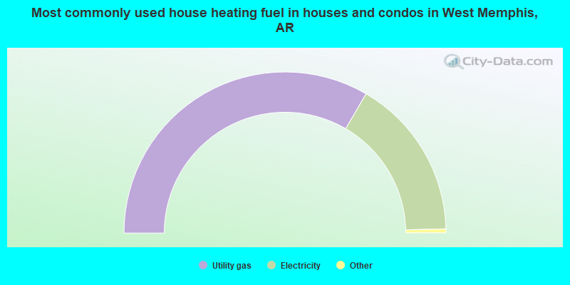
- 66.8%Utility gas
- 32.4%Electricity
- 0.5%Bottled, tank, or LP gas
- 0.3%Solar energy
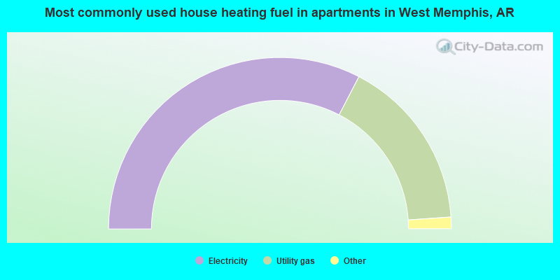
- 65.3%Electricity
- 32.6%Utility gas
- 1.4%No fuel used
- 0.4%Wood
- 0.2%Other fuel
- 0.1%Bottled, tank, or LP gas
West Memphis compared to Arkansas state average:
- Unemployed percentage below state average.
- Black race population percentage significantly above state average.
- Hispanic race population percentage significantly below state average.
- Median age below state average.
- Foreign-born population percentage significantly below state average.
- Renting percentage above state average.
- Length of stay since moving in significantly above state average.
West Memphis on our top lists:
- #4 on the list of "Top 101 cities with the highest number of burglaries per 100,000 residents, excludes tourist destinations and others with a lot of outsiders visiting based on city industries data (population 5,000+)"
- #7 on the list of "Top 101 cities with the highest city-data.com crime index, excludes tourist destinations and others with a lot of outsiders visiting based on city industries data (population 5,000+)"
- #11 on the list of "Top 101 cities with the highest number of assaults per 100,000 residents, excludes tourist destinations and others with a lot of outsiders visiting based on city industries data (population 5,000+)"
- #31 on the list of "Top 101 cities with the highest percentage of single-parent households, population 5,000+"
- #41 on the list of "Top 100 least-safe cities (highest city-data.com crime index)"
- #46 on the list of "Top 101 cities with the highest number of robberies per 100,000 residents, excludes tourist destinations and others with a lot of outsiders visiting based on city industries data (population 5,000+)"
- #64 on the list of "Top 101 cities with largest percentage of males in industries: wholesale trade (population 5,000+)"
- #75 on the list of "Top 101 cities with the largest city-data.com crime index per police officer (population 5,000+)"
- #22 on the list of "Top 101 counties with the smallest number of people without health insurance coverage in 2000 (pop. 50,000+)"
- #53 on the list of "Top 101 counties with the largest number of people moving out compared to moving in (pop. 50,000+)"
- #81 on the list of "Top 101 counties with the highest Nitrogen Dioxide air pollution readings in 2012 (ppm)"

|
Total of 3 patent applications in 2008-2024.