How can anyone argue Philly is more urban than San Francisco? (live, state)
Please register to participate in our discussions with 2 million other members - it's free and quick! Some forums can only be seen by registered members. After you create your account, you'll be able to customize options and access all our 15,000 new posts/day with fewer ads.
^nice map, i love stuff like that. It would be interesting to see the same thing for the peninsula and south bay (i'm just gonna guess there's not very much at that density in the North Bay though).
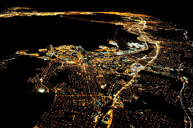
Time for lots of Bay Area aerials:
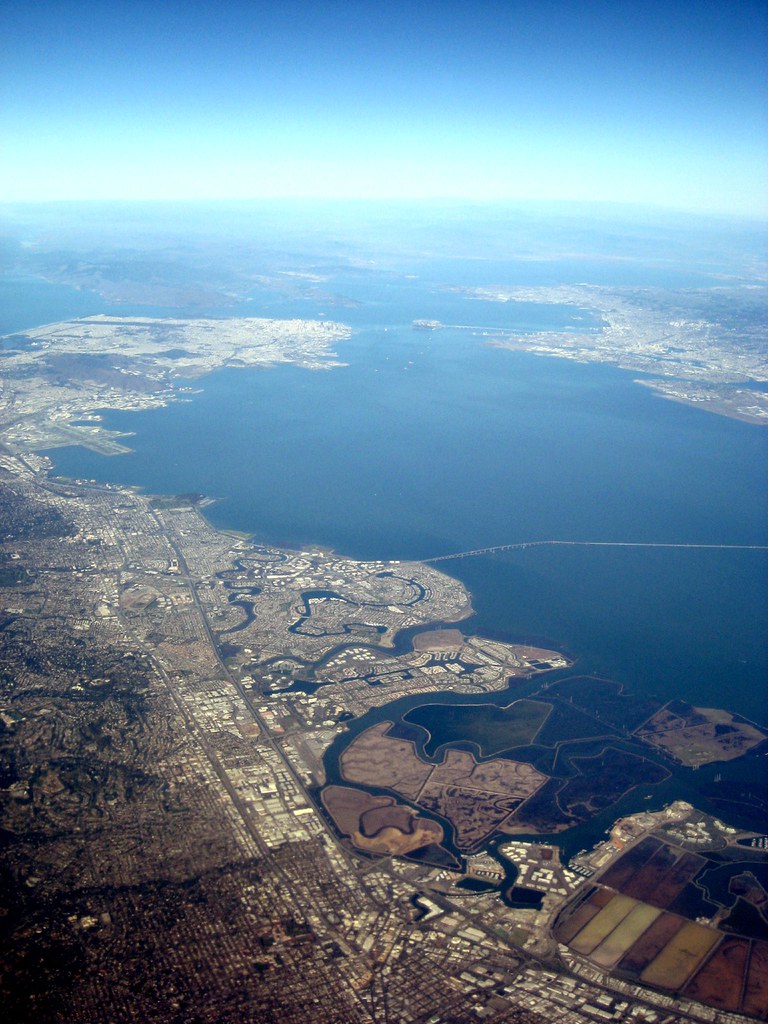
as you can see, lots of development in the east bay, and all down the peninsula:
All sizes | San Francisco Bay aerial view | Flickr - Photo Sharing! (http://www.flickr.com/photos/pr0digie/3197041351/sizes/l/in/photostream/ - broken link)
All sizes | San Francisco Bay aerial view | Flickr - Photo Sharing! (http://www.flickr.com/photos/pr0digie/3197885766/sizes/l/in/photostream/ - broken link)
part of the peninsula, south Bay, and east bay:
All sizes | San Fransciso Bay Area (http://www.flickr.com/photos/ypeterli/5443765175/sizes/z/in/photostream/ - broken link)
All sizes | San Francisco Peninsula (http://www.flickr.com/photos/ypeterli/3237693507/sizes/z/in/photostream/ - broken link)
All sizes | San Francisco Aerial View (Southwest) (Expanded) | Flickr - Photo Sharing! (http://www.flickr.com/photos/jasonferguson/352193057/sizes/z/in/photostream/ - broken link)
All sizes | SF Night | Flickr - Photo Sharing! (http://www.flickr.com/photos/vahid_69/2468338637/sizes/z/in/photostream/ - broken link)
All sizes | San Francisco Aerial Night Photography | Flickr - Photo Sharing! (http://www.flickr.com/photos/davidbush/5329255795/sizes/l/in/photostream/ - broken link)
All sizes | San Francisco Aerial Night Photography | Flickr - Photo Sharing! (http://www.flickr.com/photos/davidbush/5329867714/sizes/o/in/photostream/ - broken link)
All sizes | San Francisco Aerial Night Photography | Flickr - Photo Sharing! (http://www.flickr.com/photos/davidbush/5329255521/sizes/z/in/photostream/ - broken link)
All sizes | The City | Flickr - Photo Sharing! (http://www.flickr.com/photos/csaulit/5217413073/sizes/l/in/photostream/ - broken link)
All sizes | San Francisco Aerial View (West) | Flickr - Photo Sharing! (http://www.flickr.com/photos/jasonferguson/352198996/sizes/z/in/photostream/ - broken link)
All sizes | San Francisco / Aerial / (http://www.flickr.com/photos/lifes__too_short__to__drink__cheap__wine/2889197804/sizes/z/in/photostream/ - broken link)
All sizes | San Francisco Aerial | Flickr - Photo Sharing! (http://www.flickr.com/photos/davidwfx/158527874/sizes/z/in/photostream/ - broken link)
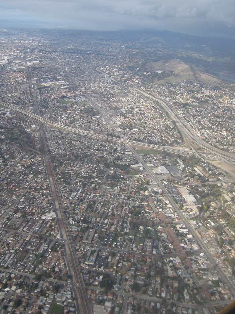
more east bay:
All sizes | Bay Area | Flickr - Photo Sharing! (http://www.flickr.com/photos/fhchong/3175266546/sizes/l/in/photostream/ - broken link)
All sizes | bye-bye, bay area | Flickr - Photo Sharing! (http://www.flickr.com/photos/allimerri/4272663822/sizes/z/in/photostream/ - broken link)
All sizes | San Francisco from the air | Flickr - Photo Sharing! (http://www.flickr.com/photos/trexcali/2141631016/sizes/z/in/photostream/ - broken link)
All sizes | More Aerials | Flickr - Photo Sharing! (http://www.flickr.com/photos/theoverheadwire/3649996938/sizes/z/in/photostream/ - broken link)
All sizes | San Francisco Bay Area Aerial | Flickr - Photo Sharing! (http://www.flickr.com/photos/meanderingmouse/3508117680/sizes/l/in/photostream/ - broken link)
All sizes | Aerial view of Oakland | Flickr - Photo Sharing! (http://www.flickr.com/photos/lben/4656544205/sizes/l/in/photostream/ - broken link)
downtown San Jose:
All sizes | San Jose, California | Flickr - Photo Sharing! (http://www.flickr.com/photos/richsnyder/5470492674/sizes/z/in/photostream/ - broken link)
All sizes | San Jose ~ Aerial | Flickr - Photo Sharing! (http://www.flickr.com/photos/avimorgan/1429094889/sizes/l/in/photostream/ - broken link)
San Jose at night:
All sizes | Birdseye view of San Jose: See where is SJC (http://www.flickr.com/photos/ypeterli/3259908624/sizes/z/in/photostream/ - broken link)
Yeah...Philadelphia wins this. It's closer to NYC, and other actual urban places. SF is sort of isolated out there in the West, unlike Los Angeles that has millions of people around it.
The Bay Area has 7.5 million in a relatively small CSA - is that enough "millions" for you?
are we playing the "show pictures of dilapidated philly hoods and views from the projects with the intent to establish that because of these eyesores the entirety of Philadelphia is discredited" game again? Because I have to warn you, those who play this game don't end up looking very bright.
You're right. People who have never visited the southern half or SF don't know that the city has the ugliest urban blight on the West Coast, period. This looks like a prison complex in a third world country. Nope, it's Potrero Hill in SF:
The FACTS that have been posted in this thread say:
SF is more dense in the downtown core.
SF is more dense on a city-wide basis Philly is more dense when comparing SF to Philly's core 47 square miles SF's urban area is smaller, but denser (and should be combined with SJ's, which would make it closer to Philly's size)
SF's metro is larger (CSA, MSA does not apply correctly to SF)
SF's metro has a higher GDP (both on the MSA and the CSA level)
SF has higher public transit usage (barely, but it does)
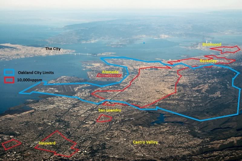
SF is nearly as dense/populated as Philly when adding Oakland and surrounding suburbs to make it equal to Philly city-proper in land area.
Philly has the tallest skyscrapers
SF has more skyscrapers
In light of all that, I fail to see how you could consider Philly as "more" urban than SF. Also, i don't exactly consider SF to be more urban than Philly...but if you want to compare, those are the facts.
If your point in bold is true, then why are we still even having this conversation?
Once you leave the whopping 47 square miles of Bay Area urbanity called San Francisco, you enter areas that more closely resemble dense East Coast suburbs like Teaneck or Hackensack than they do typical urban areas. Lots of free standing buildings, driveways, yards, and open spaces are characteristic of suburbia and Oakland, Richmond and San Jose, from what I have seen, have a whole lot of that. Don't you know that zoning ordinances often require single-family lots, houses pushed back from the sidewalk, and free standing commercial uses so that some places will feel less urban. This is why you can't get a variance to build rows of multi-family rowhouses in Upper Northwest DC. They don't want Cleveland Park to feel or look anything like Ledroit Park.
Which neighborhood do you think is more urban, btw?
The real urban core of the Bay Area, San Francisco ("the city"), is about the size of Northeast Philadelphia. If you excluded the Northeast from the DVR, and if you excluded San Francisco from the Bay Area, Philadelphia would have far more urban areas than the Bay.
Do you really think that San Jose is more urban than North Philly? Oakland more urban than West Philly? Richmond more urban than Germantown? If so, I suggest you go back and review the links posted by Nineties Flava. An area can only feel so urban with single family lots, yards, and driveways.
Last edited by BajanYankee; 08-02-2011 at 12:12 PM..
If your point in bold is true, then why are we still even having this conversation?
How convenient, you pay attention to two of the three things in the list that Philly beats SF in...and then ignore the 7 things that SF beats Philly in.
The entire point of that post was not to prove that Philly or SF is more urban, but to prove that it's basically impossible to claim that one is more urban than the other. Both are highly urban, have roughly the same population in their metros, and each has similarities as well as some pluses and minuses over the other when it comes to "urbanity".
Once you leave the whopping 47 square miles of Bay Area urbanity called San Francisco, you enter areas that more closely resemble dense East Coast suburbs like Teaneck or Hackensack than they do typical urban areas.
LOL, did you read the thread at all? Yep, these areas sure look like Hackensack, don't they:
All sizes | San Francisco Bay aerial view | Flickr - Photo Sharing! (http://www.flickr.com/photos/pr0digie/3197041351/sizes/l/in/photostream/ - broken link)
All sizes | Aerial view of Oakland | Flickr - Photo Sharing! (http://www.flickr.com/photos/lben/4656544205/sizes/l/in/photostream/ - broken link)
All sizes | San Francisco Bay aerial view | Flickr - Photo Sharing! (http://www.flickr.com/photos/pr0digie/3197041351/sizes/l/in/photostream/ - broken link)
All sizes | Bay Area | Flickr - Photo Sharing! (http://www.flickr.com/photos/fhchong/3175266546/sizes/l/in/photostream/ - broken link)
All sizes | Birdseye view of San Jose: See where is SJC (http://www.flickr.com/photos/ypeterli/3259908624/sizes/z/in/photostream/ - broken link)
All sizes | San Fransciso Bay Area (http://www.flickr.com/photos/ypeterli/5443765175/sizes/z/in/photostream/ - broken link)
By the way, that last image is of the supposedly separate SJ and SF urban areas/MSAs (you can see the southern part of the SF one, and most of the SJ one). Both of them combined have a population of 4.7 million in the urban area, which is close to Philly's UA population, and 6.3 million as an MSA, which would be larger than Philly's MSA. SF and SJ are separated on a census bureau mathematics technicality, but not by reality, as anyone who has functioning eyes, or who knows the Bay Area can see. Basically it's thanks to the location of a certain office park, which brings the continuous pop. density width threshold for combination literally just below what it needs to be (2.7 miles vs. the required 3 miles). The border between the SF/SJ urban areas and MSAs runs right through the middle of continuous development because of that. I see one continuous mass of urbanity (with smaller urban satellites in the outer east bay and north bay), not two, and the way the Bay Area's media, transportation, etc is set up reflects that as well.
Quote:
Do you really think that San Jose is more urban than North Philly? Oakland more urban than West Philly? Richmond more urban than Germantown?
When did i say any of that? NO WHERE. That's where. But for the record, i'd guess that Oakland's denser parts may give West Philly a run for it's money in urbanity, or come close to matching it at least. Having been to Philly and Oakland (never west Philly though), i really don't see that big a difference between Oakland's denser parts, and the areas i have seen in north and south philly. Central Oakland is pretty dense itself, but central Philly is more so, of course.
Once you leave the whopping 47 square miles of Bay Area urbanity called San Francisco, you enter areas that more closely resemble dense East Coast suburbs like Teaneck or Hackensack than they do typical urban areas.
Philadelphia is not exactly whoppingly dense either, is it?
I got tired after letters A-C.
Population Per Square Mile
Aston Neighborhood, Philadelphia 6,818
Crestmont Farms Neighborhood, Philadelphia 6,736
Busteton Neighborhood, Philadelphia 5,884
Ben Frankling Parkway-Kelly Drive Neighborhood, Philadelphia 5,212
Callowhill Neighborhood, Philadelphia 3,903
Ashton Woodenbridge, Phildelphia 3,680
Club District Neighborhood, Philadelphia 3,655
Byberry Neighborhood, Philadephia 3,097
Abbotsford Neighborhood, Philadelphia 3,079
Bridesburg Neighborhood, Philadelphia 2,967
Chestnut Hill Neighborhood, Philadelphia 2,541
Andorra Neighborhood, Philadelphia 1,767
LOL, did you read the thread at all? Yep, these areas sure look like Hackensack, don't they
Hackensack, NJ = 10,002 ppl per sq. mile Oakland, CA = 7,004 ppl per sq. mile
So you have a choice. You could live and die by the raw numbers here. And if you do that, then we see that Hackensack is clearly more urban than Oakland since it's the denser of the two areas. Or...you could just admit that population density figures don't tell the complete story. I don't care either way. Just know that by your standard, Hackensack (a mere bedroom community of NYC) is more urban than Oakland.
And the "we have foothills and parkland" and all of those excuses don't fly. Do you realize how much of Philadelphia (and most of the other post-industrial cities of the Northeast) is covered by oil refineries, railroad yards, industrial zones, superfund sites, airports, sports complexes and parkland? Fairmount Park gobbles up a tremendous portion of Northwest Philly. If you took all of those things out of Philly, then yeah, our density figures would be much higher, too.
Quote:
Originally Posted by rah
When did i say any of that? NO WHERE. That's where. But for the record, i'd guess that Oakland's denser parts may give West Philly a run for it's money in urbanity, or come close to matching it at least. Having been to Philly and Oakland (never west Philly though), i really don't see that big a difference between Oakland's denser parts, and the areas i have seen in north and south philly. Central Oakland is pretty dense itself, but central Philly is more so, of course.
That was directed more at Nineties Flava. He kept posting links of Oakland neighborhoods (Fruitvale, Laurel, Lake Merritt, etc) that aren't even as urban as Trenton. Go back and look at his posts.
All I have to say with regard to the bolded statement is "Wow." You don't see a difference, huh?
But let's not cherry-pick. Let's make it an apples-to-apples comparison. Let's not do something like compare Downtown Oakland to Chestnut Hill. Let's compare Lake Merritt, to say, the far Northeast on Google maps. That way you can poke around for a few blocks and see whether the density is consistent or whether it fades away after a block.
Let's take a look at the far Northeast. This is a typical residential street. You should walk around for 20 blocks or so and see how every block is this dense.
Last edited by BajanYankee; 08-02-2011 at 03:26 PM..
Please register to post and access all features of our very popular forum. It is free and quick. Over $68,000 in prizes has already been given out to active posters on our forum. Additional giveaways are planned.
Detailed information about all U.S. cities, counties, and zip codes on our site: City-data.com.


 Please register to participate in our discussions with 2 million other members - it's free and quick! Some forums can only be seen by registered members. After you create your account, you'll be able to customize options and access all our 15,000 new posts/day with fewer ads.