Please register to participate in our discussions with 2 million other members - it's free and quick! Some forums can only be seen by registered members. After you create your account, you'll be able to customize options and access all our 15,000 new posts/day with fewer ads.
The I-5 does nothing but parallel the SR99 through the San Joaquin Valley. It goes through a very empty, virtually uninhabited strip of land for hundreds of miles. They could have just widened the SR-99, added some express lanes.
Of course, one can save 1 1/2 hours driving from So. Cal. to the Bay Area on I-5 compared to the 99, but that doesn't matter to you...with plenty of gas stations and eateries along the way.
Last edited by Vic Romano; 09-08-2020 at 01:57 AM..
Here's my suggestion on how to add some north-south interstate connectivity in the Mid-Atlantic region and improve north-south travel through central Pennsylvania, while straightening out the numbering system and eliminating the numerical abomination that is I-99.
First, build a new highway that is an extension of I-85 north from South Hill, VA. (Existing I-85 from there to Petersburg can be given a three-digit number like I-185 or something.) This new road would be routed via Charlottesville and would intersect with I-81 somewhere around New Market. Then, the remainder of I-81 north of there would be renumbered as I-85.
Second, build a new highway, to be numbered I-81, from New Market north via Cumberland, MD to Bedford, PA. From there, it would use the existing I-99 up to Altoona. The new highway would continue north, replacing U.S. 219, via DuBois, PA and Salamanca, NY up to Buffalo. It would then use the existing I-190 (whose number would be deactivated) up to Niagara Falls and on to the Canadian border at Lewiston.
Third, extend I-83 north from Harrisburg, PA via a new highway that would be routed via Williamsport and up to Corning, NY. It would use the small portion of I-99 that is open in New York State. The I-99 number would be deactivated, and any remaining portions of this road that are not accounted for by I-81 or I-83 would be assigned a Pennsylvania state road number. Anyway, I-83 would then follow I-86 west and then I-390 north (the latter number would be deactivated) all the way to Rochester.
And there you'd have it. The route numbers would be in the proper order (with north-south numbers going higher as you move from west to east). The three principal cities of Upstate New York near Lake Ontario, Buffalo, Rochester, and Syracuse, would all have primary interstate highways connecting them southward to the Mid-Atlantic region. And the new I-85 would serve as an alternate route for the traffic-plagued I-95 in Virginia.
Oh, and lastly, I'd extend I-66 west from its current terminus at I-81 (now renumbered as I-85) to the new I-81, somewhere in the vicinity of Lost River, WV. Heck, while we're at it, we can keep extending it west via Clarksburg, WV (I-79), Parkersburg, WV (I-77), Chillicothe, OH (U.S. 23) and on to a new western terminus in Cincinnati, thus giving that city an east-west interstate that it currently lacks. Oh heck, why stop there? Keep going west via Columbus, IN (I-65), Bloomington, IN (I-69), then over to Terre Haute, IN to join with I-70.
Now, all I gotta do is scrounge up a few billion dollars . . .
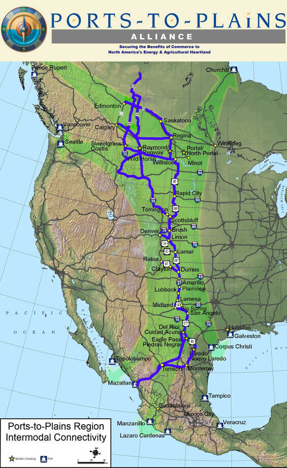
And here's another one. There's a big gap in north-south connectivity through the middle Plains states. Given their significant role in energy and agriculture, it would make sense to me to fill this gap with a new interstate highway. So I propose basically overlaying U.S. 83 with a new north-south highway, Interstate 27. This road already exists between Amarillo and Lubbock, TX. But extending it north and south would provide a link to improve access to the energy and agricultural resources of this region. Added bonus, it would finally put Pierre, SD on the interstate system, leaving just Juneau, Dover, and Jefferson City as being the only state capitals not on the system.
And here's another one. There's a big gap in north-south connectivity through the middle Plains states. Given their significant role in energy and agriculture, it would make sense to me to fill this gap with a new interstate highway. So I propose basically overlaying U.S. 83 with a new north-south highway, Interstate 27. This road already exists between Amarillo and Lubbock, TX. But extending it north and south would provide a link to improve access to the energy and agricultural resources of this region. Added bonus, it would finally put Pierre, SD on the interstate system, leaving just Juneau, Dover, and Jefferson City as being the only state capitals not on the system.
There already is a Ports-to-Plains Alliance, and Texas has authorized a feasibility/cost study to expand I-27 both north toward Oklahoma/Colorado and south to Laredo. The big difference with your plan and theirs is that they go over toward Denver, Scottsbluff and Rapid City and the western Dakotas, instead of the center of both states.
Seems odd to me that they'd bend their highway so close to the Front Range when I-25 already serves that corridor, while still leaving the midsection without a major north-south highway. I wonder what their rationale is? I wouldn't think it would be about just access to Denver, because would already be available by connecting to I-70 or I-80 to I-76. If they want to link Williston and then on to Regina, I could see using my idea but then running "I-27" to the northwest from Bismarck up that way. But then you've got the Minot Air Force Base still not connected to the National System of Interstate and Defense Highways.
Here's my suggestion on how to add some north-south interstate connectivity in the Mid-Atlantic region and improve north-south travel through central Pennsylvania, while straightening out the numbering system and eliminating the numerical abomination that is I-99.
First, build a new highway that is an extension of I-85 north from South Hill, VA. (Existing I-85 from there to Petersburg can be given a three-digit number like I-185 or something.) This new road would be routed via Charlottesville and would intersect with I-81 somewhere around New Market. Then, the remainder of I-81 north of there would be renumbered as I-85.
Second, build a new highway, to be numbered I-81, from New Market north via Cumberland, MD to Bedford, PA. From there, it would use the existing I-99 up to Altoona. The new highway would continue north, replacing U.S. 219, via DuBois, PA and Salamanca, NY up to Buffalo. It would then use the existing I-190 (whose number would be deactivated) up to Niagara Falls and on to the Canadian border at Lewiston.
Third, extend I-83 north from Harrisburg, PA via a new highway that would be routed via Williamsport and up to Corning, NY. It would use the small portion of I-99 that is open in New York State. The I-99 number would be deactivated, and any remaining portions of this road that are not accounted for by I-81 or I-83 would be assigned a Pennsylvania state road number. Anyway, I-83 would then follow I-86 west and then I-390 north (the latter number would be deactivated) all the way to Rochester.
And there you'd have it. The route numbers would be in the proper order (with north-south numbers going higher as you move from west to east). The three principal cities of Upstate New York near Lake Ontario, Buffalo, Rochester, and Syracuse, would all have primary interstate highways connecting them southward to the Mid-Atlantic region. And the new I-85 would serve as an alternate route for the traffic-plagued I-95 in Virginia.
Oh, and lastly, I'd extend I-66 west from its current terminus at I-81 (now renumbered as I-85) to the new I-81, somewhere in the vicinity of Lost River, WV. Heck, while we're at it, we can keep extending it west via Clarksburg, WV (I-79), Parkersburg, WV (I-77), Chillicothe, OH (U.S. 23) and on to a new western terminus in Cincinnati, thus giving that city an east-west interstate that it currently lacks. Oh heck, why stop there? Keep going west via Columbus, IN (I-65), Bloomington, IN (I-69), then over to Terre Haute, IN to join with I-70.
Now, all I gotta do is scrounge up a few billion dollars . . .
I like that I'm not the only one who can come with with ideas that erase Interstate 99 from Pennsylvania. Interstate 99 in Pennsylvania would not be so bad if it had a northwest-southeast slant so it could be extended to the Atlantic coast but it has a northeast-southwest slant that makes every mile of it a comparable distance from the Atlantic Ocean no matter how north or south it is extended so kill it with fire (the designation, not the road itself of course).
Please register to post and access all features of our very popular forum. It is free and quick. Over $68,000 in prizes has already been given out to active posters on our forum. Additional giveaways are planned.
Detailed information about all U.S. cities, counties, and zip codes on our site: City-data.com.

 Please register to participate in our discussions with 2 million other members - it's free and quick! Some forums can only be seen by registered members. After you create your account, you'll be able to customize options and access all our 15,000 new posts/day with fewer ads.