Please register to participate in our discussions with 2 million other members - it's free and quick! Some forums can only be seen by registered members. After you create your account, you'll be able to customize options and access all our 15,000 new posts/day with fewer ads.
Tomorrow will be the last sunny day before it becomes cloudy and cooler.. some models are showing the possibility of a very cold April, colder then the March just gone
Hey I asked you what you use to record your temperatures, because I'm curious to know. Is it a nearby station or do you use a personal one?
I use a personal weather station, from Oregon Scientific (cheaper then Davis Vantage Pro2). Shielded properly in a homemade Stevenson screen, so might be off by a few points of a degree but I think the results are fairly accurate.. I only record weather as a hobby however.
I use a personal weather station, from Oregon Scientific (cheaper then Davis Vantage Pro2). Shielded properly in a homemade Stevenson screen, so might be off by a few points of a degree but I think the results are fairly accurate.. I only record weather as a hobby however.
Same with me, my records still aren't accurate enough for anything more than that. My Davis would be fine but I think because of my garden it over reads minimum temperatures by about 1°C which is a source of perpetual bother.
Had the first thunderstorm of the year here in northwest NJ. Funny thing is, the town where I go to school got it, but my hometown 5 miles away didn't.
The next few days look to be relatively cool (48-58), with showers on Saturday. It's supposed to heat back up to the 70s on Monday.
Hmm. There was a thunderstorm last week too in NW NJ, but maybe it was very localized.
Had the first thunderstorm of the year here in northwest NJ. Funny thing is, the town where I go to school got it, but my hometown 5 miles away didn't.
The next few days look to be relatively cool (48-58), with showers on Saturday. It's supposed to heat back up to the 70s on Monday.
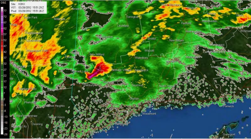
Had some loud boomers today in CT too. Hail fell in Danbury, CT and Dutchess county, NY. Lightning was vivid. There was a cell with 60dbz returns. Intense.
Here;s the radar at 11:55am. I usually dont see these until June.
Saw a couple of mosquitoes today, and I can see a little bit of grass in my yard. 45F and sunny, and supposed to be about the same for the next couple of days; it's slush city out there. This afternoon a coworker was injured when an 8ft pile of heavy, wet snow fell on him. Snow's more dangerous when it's warm than when it's cold.
9am today
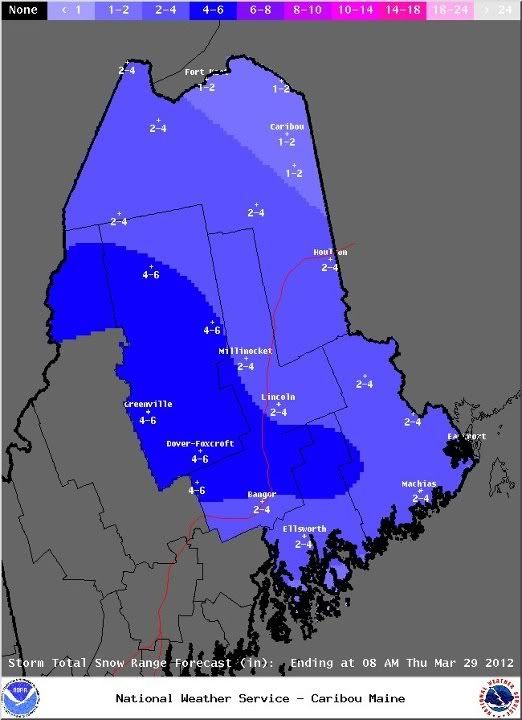
Well, after the record breaking warmth of last week it's hard to believe that snow is on the way for portions of our forecast area. An area of low pressure will move southeast from western Quebec today and then move east of the region tonight and Thursday. The graphic below shows how much snow you can expect in your area.
8pm today
...Snow continues this evening...
The image you see in previous post below is the latest forecast snowfall amounts from the NWS in Caribou for this event. So far we had reports of 1.5 inches in Presque Isle with 1 to 2 inches down across southern Piscataquis County. Less than an inch here at the office. How much snow have you received so far? Let us know. We will be updating things throughout the evening
Today was the 8th 20°C+ day in a row.
With 10 20°C+ days, this March now holds the record, far ahead March 2003 (7 20°C+ days).
The vegetation is crazy right now, daffodils are out togother with the first leaves, and everything that should normally come up inbetween.
The party will soon be over, let's see if the thriving nature likes it.
Please register to post and access all features of our very popular forum. It is free and quick. Over $68,000 in prizes has already been given out to active posters on our forum. Additional giveaways are planned.
Detailed information about all U.S. cities, counties, and zip codes on our site: City-data.com.

 Please register to participate in our discussions with 2 million other members - it's free and quick! Some forums can only be seen by registered members. After you create your account, you'll be able to customize options and access all our 15,000 new posts/day with fewer ads.