Please register to participate in our discussions with 2 million other members - it's free and quick! Some forums can only be seen by registered members. After you create your account, you'll be able to customize options and access all our 15,000 new posts/day with fewer ads.
Dumb cold fans always going on about how nice a crystal clear northerly is, cold and sunny, but never seem to get in their heads that 99.9% of northerlies have bone chilling cloud, damp, drizzly weather and record low sunshine hours, March was of course extremely sunny being very mild and even warm. Now, coldest start of April for 30 years, and avg. 2 hrs sunshine per day. Yeah, crisp sunny northerlies. Like they happen. No this is reality "cold" for you. Cold, dull, cruddy scum.
The northwestern part of Oklahoma is experiencing severe weather on 4/9. There's been brief tornado touchdowns and hail as big as baseballs. As of 6:10 PM the situation remains quite dynamic and serious.
Click on banner for more weather from north central Oklahoma.
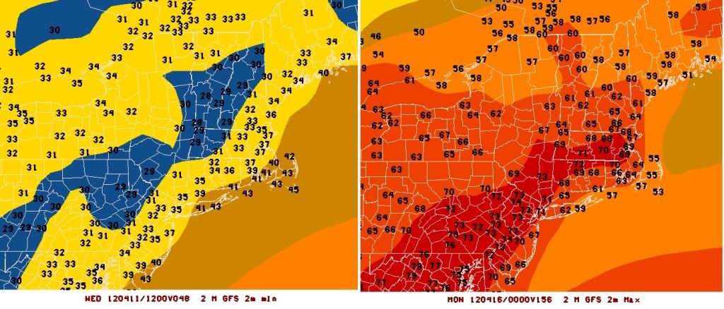
NorthEast Coldest temps on left (Wednesday morning) Warmest temps on right (Next Monday afternoon)
Watch for crop damage even down south Wednesday and Thursday nights too.
The one on the left is odd; it gets warmer to the north. No crops yet here to damage; perhaps there are further south? We got a number of mornings in the 20s last week so this one should little effect.
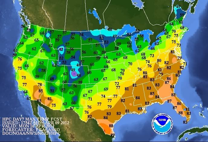
Next Monday looks exciting, though not to 80°F as weather.com forecasted.
The one on the left is odd; it gets warmer to the north. No crops yet here to damage; perhaps there are further south? We got a number of mornings in the 20s last week so this one should little effect.
Next Monday looks exciting, though not to 80°F as weather.com forecasted.
Well, I'm pretty sure that the coldest temperatures are along the Appalachian Mountains, which explains that. And of course the urban heat island and ocean current makes nights warmer along the coast and in urban areas.
As for whether the 80°F comes true or not, we'll have to wait and see. Weather Underground will show us Monday's forecast tomorrow, and I believe they are the most accurate site, so maybe we'll get an idea based on what they say.
KBOX. Euro is warmer with temps for Monday. GFS does not.
"SAT/SUN/MON... GOOD MODEL AGREEMENT ON SUBTROPICAL RIDGE DEVELOPING OVER THE SE STATES PROVIDING A NICE WARMUP HERE THIS WEEKEND. HOWEVER UNCERTAINTY EXIST ON HOW QUICKLY THIS RIDGE BREAKS DOWN DAYS 6-7 WITH THE OPERATIONAL GFS FASTER THAN THE ECMWF. THE GFS SUGGEST A FROPA LATE IN THE WEEKEND WITH THE ECMWF ABOUT A DAY LATER...LATE MON. THE 00Z/09 ECENS AND GEFS ENSEMBLES PROVIDE MORE EAST RIDGING AND CORRESPONDING WARMER TEMPS INTO EARLY NEXT. THUS MORE SUPPORT FOR THE SLOWER 12Z ECMWF. AS A RESULT WE WILL LEAN AWAY FROM THE GFS AND PUT MORE WEIGHT INTO THE 12Z ECMWF GIVEN SUPPORT FROM THE GEFS AND ECENS. THEREFORE OUR FCST IS DRIER SAT THAN THE GFS AND ALSO WARMER MON THAN THE GFS"
It looks like a forest fire has broken out in the area. This picture was taken from facebook. It's hard to tell, but that's the mountain in the distance and it looks like a fairly significant fire.
Wow! Yikes. I'm wondering how often it is for a forest type like that (east coast hardwoods) to have a fire burning so early (not even in summer or an especially hot season absolutely speaking) but just due to dryness in spring (and even before all the trees have had their leaves too!).
Wow! Yikes. I'm wondering how often it is for a forest type like that (east coast hardwoods) to have a fire burning so early (not even in summer or an especially hot season absolutely speaking) but just due to dryness in spring (and even before all the trees have had their leaves too!).
For some reason, I've seen red flag warnings more in early spring than any other season. Relative humidity and dry spells might be more frequent, then.
2000 acres burned in eastern Long Island, scattered small fires across the island.
Please register to post and access all features of our very popular forum. It is free and quick. Over $68,000 in prizes has already been given out to active posters on our forum. Additional giveaways are planned.
Detailed information about all U.S. cities, counties, and zip codes on our site: City-data.com.

 Please register to participate in our discussions with 2 million other members - it's free and quick! Some forums can only be seen by registered members. After you create your account, you'll be able to customize options and access all our 15,000 new posts/day with fewer ads.


") Like they happen. No this is reality "cold" for you. Cold, dull, cruddy scum.
Like they happen. No this is reality "cold" for you. Cold, dull, cruddy scum.