Please register to participate in our discussions with 2 million other members - it's free and quick! Some forums can only be seen by registered members. After you create your account, you'll be able to customize options and access all our 15,000 new posts/day with fewer ads.
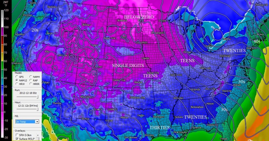
The new station of dorozhny in Siberia is beating Oymyakon so far this winter as the north pole of cold.
Recorded -55.5ºC (-68ºF) two days ago while Oymyakon reached "only" -54.5ºC (-66ºF).
Impressive.
Now that's what I call a good old fashioned winter. We need to have a couple of seasons like that here to get back into the norm of things. Thanks for the link, I really enjoyed that.
I imagine that autumns persisting for 6 or 7 months would be stressful on most of us snow fans. Autumns persisting through winter is what you tried to move away from, if I'm not mistaken. If I were moving from the South to a more northerly location, I'd pick a spot with much more secure winters than Ann Arbor, practicalities of your situation aside. With December and February averaging a high of 35F and January 31F, it is very easy to get warm enough to make rain and melt snow, and records stand in the 60's and 70's. In my opinion, the best American winters are to be found in certain spots in the Mountain West and Alaska.
Yes, pretty much. I could try moving to the UP or West Michigan if I wanted to. The culture isn't to my liking, though... I'd rather move to Canada. London would have everything I want and a crapload of lake effect to go with it
Winter Storm Watch in effect for Des Moines, IA (just one area in the bulls eye of the next storm):
...WINTER STORM WATCH REMAINS IN EFFECT FROM WEDNESDAY AFTERNOON
THROUGH THURSDAY AFTERNOON...
* TIMING...PRECIPITATION WILL OVERSPREAD CENTRAL IOWA ON
WEDNESDAY AFTERNOON. SNOW IS EXPECTED ALONG AND NORTH OF AN
ATLANTIC THROUGH BOONE TO WATERLOO LINE. RAIN IS EXPECTED IN
SOUTHERN IOWA SOUTH OF A BEDFORD TO OSKALOOSA LINE. IN
BETWEEN...A RAIN AND SNOW MIX IS EXPECTED. THIS PRECIPITATION
WILL CHANGE TO ALL SNOW ON WEDNESDAY NIGHT BEFORE ENDING ON
THURSDAY MORNING.
* STORM TOTAL SNOW ACCUMULATION...5 TO 8 INCHES OF SNOW IS
EXPECTED IN THE WATCH AREA. LOCAL AMOUNTS OF UP TO 10 INCHES
WILL BE POSSIBLE WITH DRIFTS EVEN HIGHER.
* WINDS/VISIBILITY...WINDS WILL BECOME VERY STRONG ON WEDNESDAY
NIGHT FROM THE NORTH TO NORTHWEST. SUSTAINED WINDS OF 20 TO 30
MPH ARE EXPECTED WITH GUSTS OVER 35 MPH POSSIBLE. THE STRONGEST
WINDS ARE EXPECTED AROUND DAYBREAK ON THURSDAY WITH BLIZZARD OR NEAR
BLIZZARD CONDITIONS POSSIBLE WITH VISIBILITIES REDUCED BELOW ONE
QUARTER OF A MILE FROM TIME TO TIME.
Forecast for the upcoming week looks quite nippy out there:
Overnight: A 30 percent chance of snow. Cloudy, with a low around 29. Southeast wind 6 to 9 mph. Little or no snow accumulation expected.
Tuesday: Cloudy, then gradually becoming mostly sunny, with a high near 45. South wind 9 to 13 mph becoming west northwest in the afternoon. Winds could gust as high as 18 mph.
Tuesday Night: Mostly cloudy, with a low around 28. West northwest wind 5 to 8 mph becoming northeast after midnight.
Wednesday: Rain and snow after noon. High near 36. Northeast wind 5 to 15 mph, with gusts as high as 23 mph. Chance of precipitation is 80%. New precipitation amounts between a tenth and quarter of an inch possible.
Wednesday Night: Snow with areas of blowing snow. Low around 23. Windy, with a north northwest wind 16 to 25 mph, with gusts as high as 38 mph. Chance of precipitation is 90%.
Thursday: Areas of blowing snow and a chance of snow before noon, then areas of blowing snow after noon. Partly sunny, with a high near 24. Windy. Chance of precipitation is 40%.
Thursday Night: Mostly clear, with a low around 11. Blustery.
Friday: Sunny, with a high near 29.
Friday Night: Mostly clear, with a low around 15.
Saturday: Sunny, with a high near 31.
Saturday Night: Partly cloudy, with a low around 15.
Sunday: Mostly sunny, with a high near 28.
Sunday Night: Partly cloudy, with a low around 14.
The models might be converging on the solution I posted earlier, which would be good for lake-effect and upslope snows.
The local NWS here is still not willing to put it in concrete, but this is their latest postings about the low.
Scenario 2: The low pressure system may track south of our area, somewhere closer to the Thumb of Michigan. This would place just about all of northern Michigan on the cold side of the storm, with heavy snow a distinct possibility. Gusty northwest winds would also provide blowing and drifting snow, with significant lake effect snow also possible through the weekend. NOTE: This solution appears increasingly likely.
As mentioned above, the latest expectations are that the low will track south of the area, but we will still have to wait another day to be sure. Those with holiday travel plans across the area late in the week, or into the weekend, should keep a close eye on later forecasts as hazardous travel is quite possible.
Looking forward to some cold and blustery weather this weekend. Very appropriate the weekend before Christmas. Maybe I'll head up to High Point, NJ.
A VIGOROUS COLD FRONT IS FORECAST TO MOVE THROUGH THE REGION ON
FRIDAY. PRECEDING IT, SHOWERS WITH LOCALLY HEAVY RAIN ARE POSSIBLE.
FOLLOWING THE FRONT, A PROLONGED PERIOD OF STRONG, BLUSTERY WINDS
ARE LIKELY. WIND GUSTS MIGHT REACH WIND ADVISORY CRITERIA ON
FRIDAY AND SATURDAY. THERE WILL ALSO BE SCATTERED SNOW SHOWERS
AROUND LATER FRIDAY INTO SATURDAY, HIGHEST CHANCES IN NORTHWEST NEW
JERSEY AND TOWARD THE POCONOS.
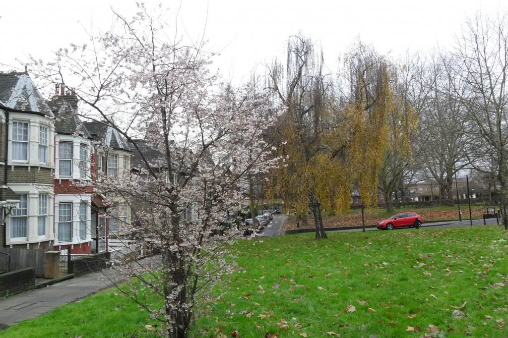
Took this picture of our confused flora earlier on. I don't know why the trees are confused as to which season it is as the whole of the past three months have been below average more often than not. I don't remember seeing something as odd as that at this time last year even though late 2011 was much milder.
Talking about confused trees there are trees near where I lie that were green even up to maybe a few days ago, now the leafs have dropped off but didnt go through the colouring stage.
Please register to post and access all features of our very popular forum. It is free and quick. Over $68,000 in prizes has already been given out to active posters on our forum. Additional giveaways are planned.
Detailed information about all U.S. cities, counties, and zip codes on our site: City-data.com.

 Please register to participate in our discussions with 2 million other members - it's free and quick! Some forums can only be seen by registered members. After you create your account, you'll be able to customize options and access all our 15,000 new posts/day with fewer ads.


 Maybe I'll head up to High Point, NJ.