Please register to participate in our discussions with 2 million other members - it's free and quick! Some forums can only be seen by registered members. After you create your account, you'll be able to customize options and access all our 15,000 new posts/day with fewer ads.
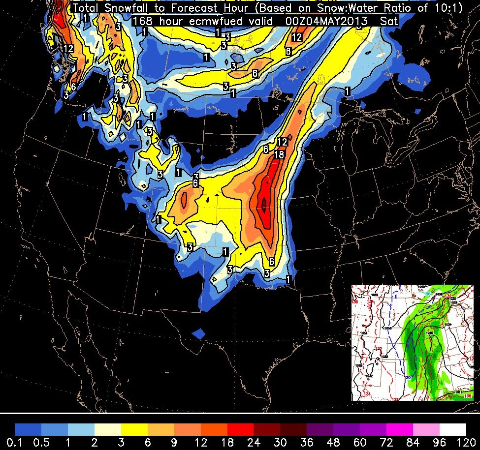
Euro now onto the snow game. Its showing a Major snowstorm next week all the way down to Texas.
Keep in mind this is based on 10:1 ratios so lower the totals from melting and from lower ratios. This is not a forecast. Just what the model produced after fresh data got injected into it.
It's Funny I havent been counting down to fall and winter yet this year.. Usually I start in March. I guess cause winter keeps showing up somewhere and temps are not summer like around here yet.
I'm gonna have to go with wavehunter on this one, Cambium. I checked my forecast for the next week and it's only gonna be low to mid 60s for me. We'll have to wait until the day comes to see if the GFS and Euro models were correct, I'm highly skeptical that they are
I'm gonna have to go with wavehunter on this one, Cambium. I checked my forecast for the next week and it's only gonna be low to mid 60s for me. We'll have to wait until the day comes to see if the GFS and Euro models were correct, I'm highly skeptical that they are
A reminder to all.... "forecasts" are not pulled from a hat... they are based on "models".
Hello? "computer models". LMAO! There's more to it then saying one run is the forecast. We need to evaluate each update, look for consistancy, and use personal opinion at times. But recently the personal opinions has stabbed Meteos and NWS in their back because weather is sometimes goes against climotology.
Bottom line... the "foreasts" you see are from "computer models" and we know those forecasts fail sometimes.. Guess why, because the model data results changed.
MODELS CONTINUE TO TREND WEST WITH THE EVENTUAL DEVELOPMENT OF AN
UPPER LOW...WHICH THE EURO WANTS TO CUT OFF NEAR THE TEXAS
PANHANDLE FRIDAY...WHILE THE GFS MAKES IT CUTOFF OVER THE AREA OF
KY/TN IN THE SAME TIME FRAME. THE PROBLEM IS WHAT HAPPENS LOCALLY
AS THE EURO WOULD HAVE A HUGE BLOCKING UPPER HIGH CLOSED OFF
RIGHT OVERHEAD...
A reminder to all.... "forecasts" are not pulled from a hat... they are based on "models".
Hello? "computer models". LMAO! There's more to it then saying one run is the forecast. We need to evaluate each update, look for consistancy, and use personal opinion at times. But recently the personal opinions has stabbed Meteos and NWS in their back because weather is sometimes goes against climotology.
Bottom line... the "foreasts" you see are from "computer models" and we know those forecasts fail sometimes.. Guess why, because the model data results changed.
I know forecasts are based on models, as I'm sure every other regular poster on here does. For me, the beef is the forecast seems a little too...out there. When there's potential records to be broken like what you are showing, I naturally get skeptical on the eventual results. The chances of a forecast to be deviating from the average like that are pretty slim, so for this I definitely will have to wait and see if it changes or not, because tomorrow the forecast could be adjusted, and so on. As you can probably tell, I'm not a betting man
Good link to keep. It shows the GFS forecast temps. But again... GFS has 4 updates per day. EURO 2 updates per day. NAM 4 per day.
There's litterally over 15 model updates per day so changes do happen with each one.. Thats why whenever I show a model update on something interesting, I make sure I mention "its not a forecast and its just one or several runs". I then add if I believe it or not.
Random GFS MOS forecast pick. Atlantic City, NJ. Pretty seasonable with some warm days.
One of the worst aspects of today’s weather forecasting (perhaps THE worst) is what is known as “model fantasy”. This is when computer models forecast extreme events….with little logic…..based on million to one assumptions. From run to run, these wild events are forecasted all over the map, to the west, to east, to north…etc with little sense or logic. Worse, sometimes these computer generated fantasies are not just for extremely rare events (with 100…or 500 year return periods - lol)….they are for unprecedented events- events that defy logic, reason…and at times even sanity.
Fantasy? Defying logic and reason? Hardly. Of course such an event could happen under the right conditions, and the conditions are right for snow if this scenario plays out. When every single computer model is showing an event around the same time period for days on end, it stands a serious chance of happening, no matter how extreme or unprecedented it is. I suppose according to your view Hurricane Sandy was a deception and the unprecedented snowfall must have been an outright hallucination . Also, that huge, unprecedented pre-Halloween snowstorm? That must have just been in our minds. You can't deny it now that those events actually happened, but every computer model consistently showed these events well in advance, and people like you were saying "it's unprecedented, it can't happen, blah, blah, blah" right up to the end.
There's actually more support for this huge snow event than this pattern change to huge warmth you've been harping on for the past two weeks, but the huge snow is decried as a fantasy, and the warmth or the typical pattern is considered to be the only one that is realistic or can ever happen. How typical. More examples of events that were unprecedented at the time they occurred include Lake Storm Aphid, the late southern snowstorm of April 1910, the April Fool's Day Blizzard of 1997, and the Super Outbreak of 1974.
Don't take the above graphic personally. I'm just teasing you . If you made a similar graphic ridiculing me and "computer fantasies" I wouldn't mind.
You shouldn't be checking NWS forecasts at this stage, because if an extreme scenario is shown by every model one week out the public forecasters are typically much more cautious, i.e. if there's good model support for a record freeze one week out, they will put out 60/40F on the forecast (well below normal temps), and the forecast will eventually be lowered to 32F when we're 48 hours out. One week out from Hurricane Sandy's snowfall you didn't see heavy snow on the NWS forecast, and one week out from the 2011 October snowstorm you didn't see snow on the NWS forecast this early, either, yet both happened. If the models continue to show this scenario for the next week, you can bet your boots that those forecasts you're citing now will change.
As for the Florida frost, there's much less support for that than extreme cold and extreme snow somewhere in the East; frost reaching down into Florida is an upper bound on the strength of the cold air and the storm track. If the low tracks towards the east as opposed to the Plains, northern Florida will probably drop into the 50's. Whether they continue showing this or not is an open question, as it always is for any storm that's a week out. However, at this point I'm about as confident as one can be at this stage that an upper-level low is coming into the Eastern U.S. with record cold and very rare or unprecedented snowfall. The location, track, duration, and the exact intensity of this storm is less certain.
In any case, let's try not to have bitter arguments with each other for the next week. In 7 days we'll see which scenario, if any, verifies, so let's cool it for now and try to keep an open mind.
Euro now onto the snow game. Its showing a Major snowstorm next week all the way down to Texas.
Keep in mind this is based on 10:1 ratios so lower the totals from melting and from lower ratios. This is not a forecast. Just what the model produced after fresh data got injected into it.
It's Funny I havent been counting down to fall and winter yet this year.. Usually I start in March. I guess cause winter keeps showing up somewhere and temps are not summer like around here yet.
I'll believe it when I see it.
Please register to post and access all features of our very popular forum. It is free and quick. Over $68,000 in prizes has already been given out to active posters on our forum. Additional giveaways are planned.
Detailed information about all U.S. cities, counties, and zip codes on our site: City-data.com.

 Please register to participate in our discussions with 2 million other members - it's free and quick! Some forums can only be seen by registered members. After you create your account, you'll be able to customize options and access all our 15,000 new posts/day with fewer ads.


 Euro now onto the snow game.