Big Bear, California
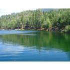
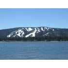
Big Bear: Big Bear Lake
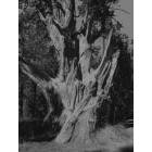
Big Bear: Gnarley
Big Bear: big bear, ca
Big Bear: big bear, ca
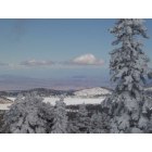
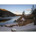
Big Bear: After the storm during Christmas 2008.
Big Bear: big bear, ca
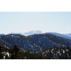
Big Bear: the summit
Big Bear: Frozen lake Baldwin
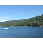
Big Bear: Big Bear
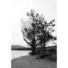
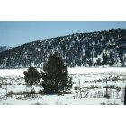
Big Bear: Tree on North Shore
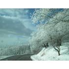
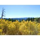
Big Bear: Winter Wonderland
- add
your
Submit your own pictures of this place and show them to the world
- OSM Map
- General Map
- Google Map
- MSN Map
| Males: 14,576 | |
| Females: 14,261 |
| Median resident age: | 40.2 years |
| California median age: | 33.3 years |
Zip code: 92314
| Big Bear: | $73,281 |
| CA: | $91,551 |
Estimated per capita income in 2022: $39,570 (it was $21,160 in 2000)
Big Bear CCD income, earnings, and wages data
Estimated median house or condo value in 2022: $550,842 (it was $136,400 in 2000)
| Big Bear: | $550,842 |
| CA: | $715,900 |
Mean prices in 2022: all housing units: $538,674; detached houses: $572,275; townhouses or other attached units: $512,095; in 2-unit structures: $547,337; in 3-to-4-unit structures: $471,159; in 5-or-more-unit structures: $418,370; mobile homes: $119,083; occupied boats, rvs, vans, etc.: $73,388
Detailed information about poverty and poor residents in Big Bear, CA


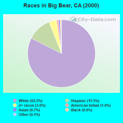
- 20,51282.5%White alone
- 2,85811.5%Hispanic
- 8883.6%Two or more races
- 2461.0%American Indian alone
- 1640.7%Asian alone
- 1450.6%Black alone
- 350.1%Other race alone
- 170.07%Native Hawaiian and Other
Pacific Islander alone
According to our research of California and other state lists, there was 1 registered sex offender living in Big Bear, California as of May 04, 2024.
The ratio of all residents to sex offenders in Big Bear is 28,837 to 1.
The ratio of registered sex offenders to all residents in this city is much lower than the state average.
 Recent articles from our blog. Our writers, many of them Ph.D. graduates or candidates, create easy-to-read articles on a wide variety of topics.
Current Local Time: PST time zone
Elevation: 6757 feet
Land area: 537.1 square miles.
Population density: 54 people per square mile (very low).
| Big Bear CCD: | 1.0% ($1,335) |
| California: | 0.8% ($1,564) |
Nearest city with pop. 50,000+: Redlands, CA  (19.2 miles , pop. 63,591).
Nearest city with pop. 200,000+: Riverside, CA (34.0 miles , pop. 255,166).
Nearest city with pop. 1,000,000+: Los Angeles, CA (84.4 miles , pop. 3,694,820).
Nearest cities:
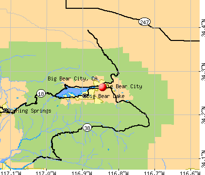
), ), ), ), Latitude: 34.23 N, Longitude: 116.91 W
Area code: 909
| Here: | 5.0% |
| California: | 5.1% |
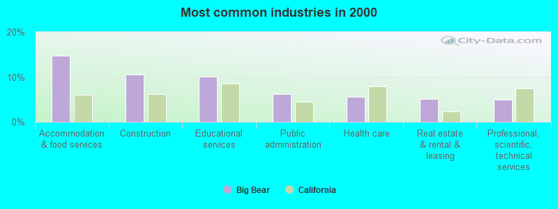
- Accommodation & food services (14.8%)
- Construction (10.5%)
- Educational services (10.1%)
- Public administration (6.2%)
- Health care (5.6%)
- Real estate & rental & leasing (5.2%)
- Professional, scientific, technical services (5.0%)
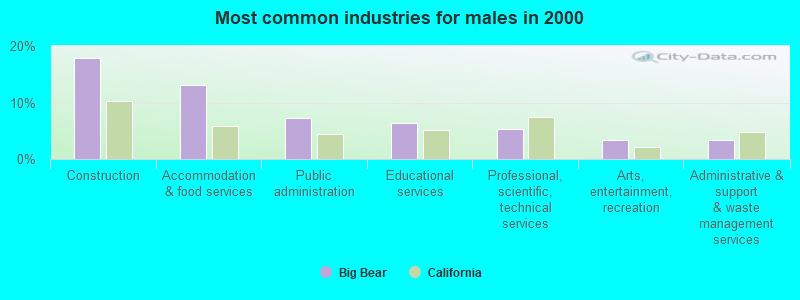
- Construction (17.9%)
- Accommodation & food services (13.2%)
- Public administration (7.3%)
- Educational services (6.4%)
- Professional, scientific, technical services (5.2%)
- Arts, entertainment, recreation (3.4%)
- Administrative & support & waste management services (3.4%)
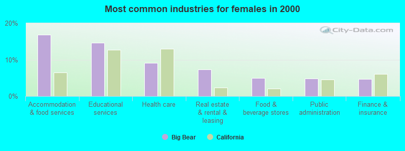
- Accommodation & food services (16.8%)
- Educational services (14.6%)
- Health care (9.1%)
- Real estate & rental & leasing (7.2%)
- Food & beverage stores (4.9%)
- Public administration (4.8%)
- Finance & insurance (4.7%)
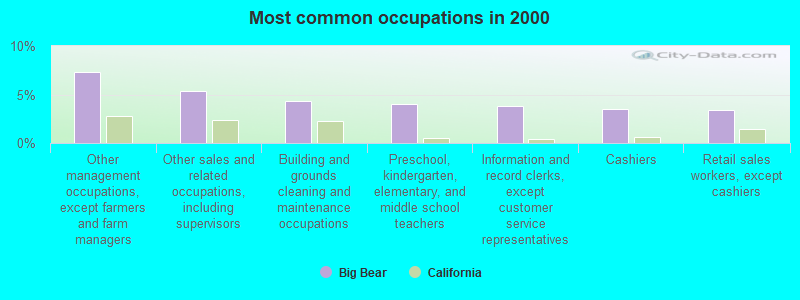
- Other management occupations, except farmers and farm managers (7.3%)
- Other sales and related occupations, including supervisors (5.3%)
- Building and grounds cleaning and maintenance occupations (4.4%)
- Preschool, kindergarten, elementary, and middle school teachers (4.0%)
- Information and record clerks, except customer service representatives (3.8%)
- Cashiers (3.5%)
- Retail sales workers, except cashiers (3.4%)
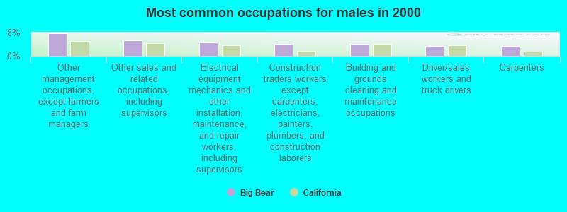
- Other management occupations, except farmers and farm managers (7.8%)
- Other sales and related occupations, including supervisors (5.4%)
- Electrical equipment mechanics and other installation, maintenance, and repair workers, including supervisors (4.7%)
- Construction traders workers except carpenters, electricians, painters, plumbers, and construction laborers (4.2%)
- Building and grounds cleaning and maintenance occupations (4.0%)
- Driver/sales workers and truck drivers (3.4%)
- Carpenters (3.3%)
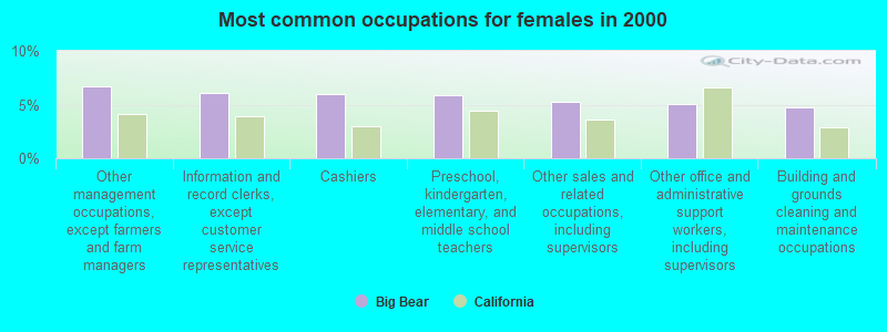
- Other management occupations, except farmers and farm managers (6.7%)
- Information and record clerks, except customer service representatives (6.1%)
- Cashiers (6.0%)
- Preschool, kindergarten, elementary, and middle school teachers (5.9%)
- Other sales and related occupations, including supervisors (5.3%)
- Other office and administrative support workers, including supervisors (5.0%)
- Building and grounds cleaning and maintenance occupations (4.8%)
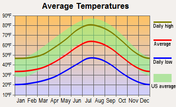
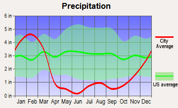
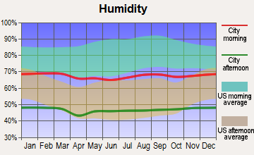
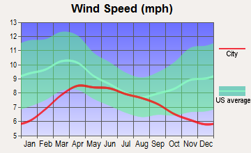
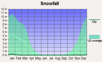
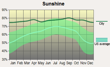
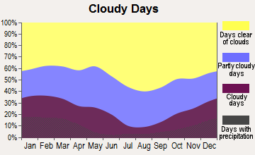
Average climate in Big Bear, California
Based on data reported by over 4,000 weather stations
|
|

(lower is better)
Air Quality Index (AQI) level in 2023 was 137. This is significantly worse than average.
| City: | 137 |
| U.S.: | 73 |

Carbon Monoxide (CO) [ppm] level in 2022 was 0.301. This is about average. Closest monitor was 2.3 miles away from the city center.
| City: | 0.301 |
| U.S.: | 0.251 |
Nitrogen Dioxide (NO2) [ppb] level in 2022 was 6.70. This is worse than average. Closest monitor was 20.0 miles away from the city center.
| City: | 6.70 |
| U.S.: | 5.11 |
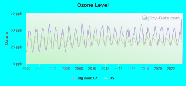
Ozone [ppb] level in 2023 was 44.4. This is worse than average. Closest monitor was 2.3 miles away from the city center.
| City: | 44.4 |
| U.S.: | 33.3 |
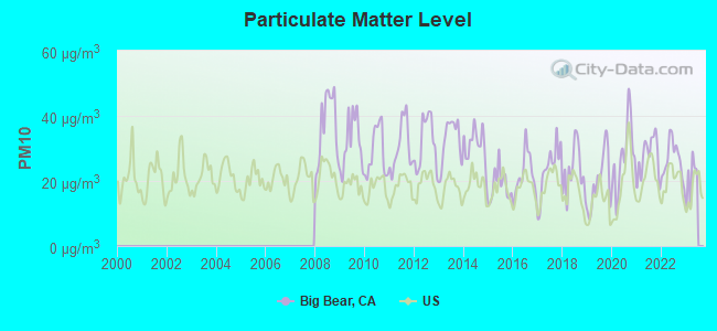
Particulate Matter (PM10) [µg/m3] level in 2022 was 26.5. This is worse than average. Closest monitor was 12.2 miles away from the city center.
| City: | 26.5 |
| U.S.: | 19.2 |
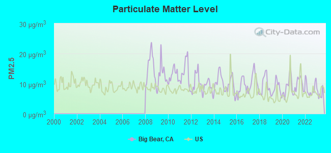
Particulate Matter (PM2.5) [µg/m3] level in 2023 was 6.61. This is better than average. Closest monitor was 3.6 miles away from the city center.
| City: | 6.61 |
| U.S.: | 8.11 |
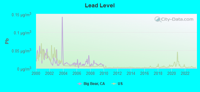
Lead (Pb) [µg/m3] level in 2009 was 0.0106. This is about average. Closest monitor was 17.9 miles away from the city center.
| City: | 0.0106 |
| U.S.: | 0.0093 |
Earthquake activity:
Big Bear-area historical earthquake activity is significantly above California state average. It is 7392% greater than the overall U.S. average.On 6/28/1992 at 11:57:34, a magnitude 7.6 (6.2 MB, 7.6 MS, 7.3 MW, Depth: 0.7 mi, Class: Major, Intensity: VIII - XII) earthquake occurred 22.0 miles away from the city center, causing 3 deaths (1 shaking deaths, 2 other deaths) and 400 injuries, causing $100,000,000 total damage and $40,000,000 insured losses
On 10/16/1999 at 09:46:44, a magnitude 7.4 (6.3 MB, 7.4 MS, 7.2 MW, 7.3 ML) earthquake occurred 33.5 miles away from the city center
On 7/21/1952 at 11:52:14, a magnitude 7.7 (7.7 UK) earthquake occurred 130.1 miles away from the city center, causing $50,000,000 total damage
On 6/28/1992 at 15:05:30, a magnitude 6.9 (6.3 MB, 6.7 MS, 6.5 MW, 6.9 ME, Depth: 3.1 mi, Class: Strong, Intensity: VII - IX) earthquake occurred 6.7 miles away from Big Bear center
On 5/19/1940 at 04:36:40, a magnitude 7.2 (7.2 UK) earthquake occurred 98.9 miles away from Big Bear center, causing $33,000,000 total damage
On 4/21/1918 at 22:32:30, a magnitude 6.8 (6.8 UK) earthquake occurred 42.0 miles away from Big Bear center
Magnitude types: body-wave magnitude (MB), energy magnitude (ME), local magnitude (ML), surface-wave magnitude (MS), moment magnitude (MW)
Natural disasters:
The number of natural disasters in San Bernardino County (46) is a lot greater than the US average (15).Major Disasters (Presidential) Declared: 27
Emergencies Declared: 2
Causes of natural disasters: Fires: 24, Floods: 18, Storms: 9, Winter Storms: 6, Landslides: 5, Mudslides: 4, Heavy Rains: 2, Earthquake: 1, Flash Flood: 1, Freeze: 1, Hurricane: 1, Snow: 1, Tornado: 1, Tropical Storm: 1, Wind: 1, Other: 1 (Note: some incidents may be assigned to more than one category).

Colleges/universities with over 2000 students nearest to Big Bear:
- Crafton Hills College (about 18 miles; Yucaipa, CA; Full-time enrollment: 3,222)
- University of Redlands (about 19 miles; Redlands, CA; FT enrollment: 4,854)
- The Art Institute of California-Argosy University Inland Empire (about 24 miles; San Bernardino, CA; FT enrollment: 2,238)
- Loma Linda University (about 24 miles; Loma Linda, CA; FT enrollment: 2,839)
- California State University-San Bernardino (about 24 miles; San Bernardino, CA; FT enrollment: 15,748)
- San Bernardino Valley College (about 26 miles; San Bernardino, CA; FT enrollment: 7,444)
- Victor Valley College (about 26 miles; Victorville, CA; FT enrollment: 7,630)
Points of interest:
Notable locations in Big Bear: Old Baldy Council Camp (A), Pasadena Camp (B), Ironwood Campsite (C), Horse Spring Campground (D), Hitchcock Ranch (E), Hawes Ranch (F), Harold F Whittle Camp (G), Green Valley Recreation Area (H), Green Valley Campground (I), Grays Campsite (J), Fishermans Campground (K), Deer Lick Station (L), Council Campground (M), Converse Forest Service Station (N), Coldbrook Campground (O), Camp Wintaka (P), Camp Tahquitz (Q), Camp Ta Ta Pochon (R), Camp Sky Meadow (S), Camp Round Meadow (T). Display/hide their locations on the map
Shopping Centers: Lakeview Shopping Center (1), Interlaken Shopping Center (2). Display/hide their locations on the map
Churches in Big Bear include: Fawnskin Community Church (A), Green Valley Lake Community Church (B). Display/hide their locations on the map
Cemetery: Wilbur Grave (1). Display/hide its location on the map
Lakes, reservoirs, and swamps: Rainbow Lake (A), Baldwin Lake (B), The Tarn (C), Jenks Lake (D), Green Valley Lake (E), Dollar Lake (F), Dry Lake (G), Deep Creek Lake (H). Display/hide their locations on the map
Streams, rivers, and creeks: Oak Creek (A), Oak Cove Creek (B), North Fork Whitewater River (C), High Creek (D), North Creek (E), East Fork Whitewater River (F), Crystal Creek (G), Monkeyface Creek (H), Momyer Creek (I). Display/hide their locations on the map
Parks in Big Bear include: Meadow Park (1), Heart Bar State Park (2), Aspen Glen Picnic Area (3), Animal Park (4), Green Canyon Group Camp (5), Green Spot Picnic Area (6), Thurman Flats Picnic Area (7), Washington Monument (8), Big Bear City Park (9). Display/hide their locations on the map
Hotel: Big Bear Lake Adventure Hostel Reservations (527 Knickerbocker Road) (1). Display/hide its approximate location on the map
| This place: | 2.4 people |
| California: | 2.9 people |
| This place: | 64.9% |
| Whole state: | 68.7% |
| This place: | 7.8% |
| Whole state: | 7.2% |
Likely homosexual households (counted as self-reported same-sex unmarried-partner households)
- Lesbian couples: 0.6% of all households
- Gay men: 0.8% of all households
| This place: | 11.5% |
| Whole state: | 14.2% |
| This place: | 4.7% |
| Whole state: | 6.3% |
People in group quarters in Big Bear in 2010:
- 156 people in state prisons
- 21 people in nursing facilities/skilled-nursing facilities
- 12 people in group homes intended for adults
- 10 people in workers' group living quarters and job corps centers
- 6 people in other noninstitutional facilities
People in group quarters in Big Bear in 2000:
- 157 people in other workers' dormitories
- 124 people in other noninstitutional group quarters
- 19 people in nursing homes
- 5 people in religious group quarters
- 2 people in other nonhousehold living situations
For population 15 years and over in Big Bear:
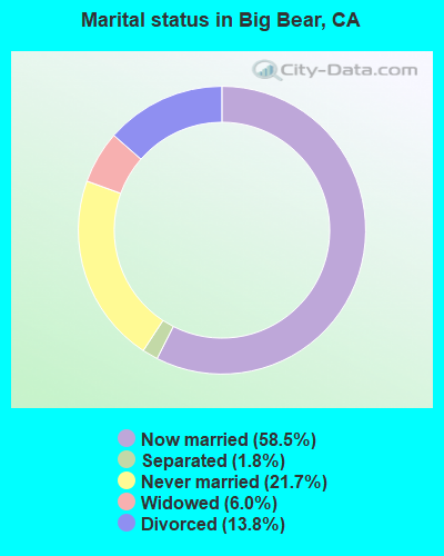
- Never married: 21.7%
- Now married: 58.5%
- Separated: 1.8%
- Widowed: 6.0%
- Divorced: 13.8%
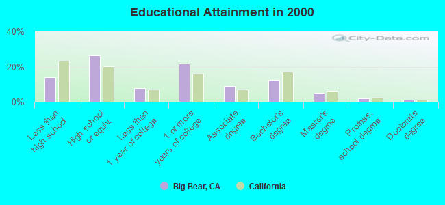
For population 25 years and over in Big Bear:
- High school or higher: 86.1%
- Bachelor's degree or higher: 20.8%
- Graduate or professional degree: 8.2%
- Unemployed: 4.8%
- Mean travel time to work (commute): 28.2 minutes
| Here: | 9.9 |
| California average: | 16.1 |
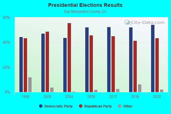
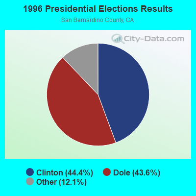
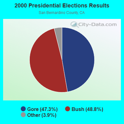
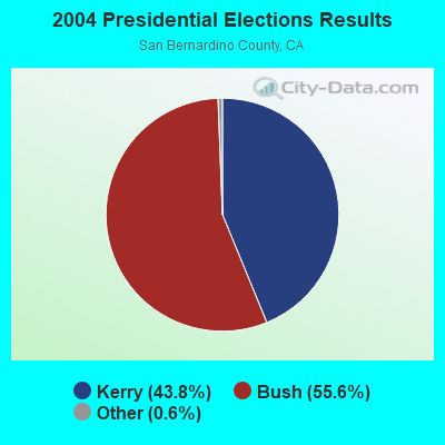
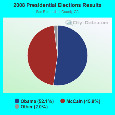
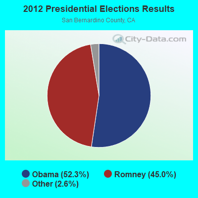
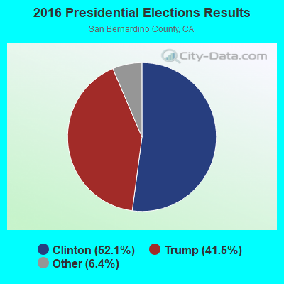
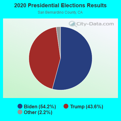
Graphs represent county-level data. Detailed 2008 Election Results
Religion statistics for Big Bear, CA (based on San Bernardino County data)
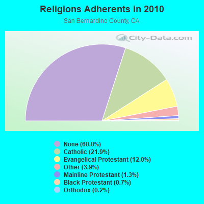
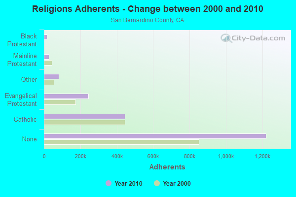
| Religion | Adherents | Congregations |
|---|---|---|
| Catholic | 445,334 | 55 |
| Evangelical Protestant | 243,524 | 832 |
| Other | 80,047 | 205 |
| Mainline Protestant | 26,062 | 135 |
| Black Protestant | 14,969 | 37 |
| Orthodox | 3,868 | 10 |
| None | 1,221,406 | - |
Food Environment Statistics:
| San Bernardino County: | 1.50 / 10,000 pop. |
| California: | 2.14 / 10,000 pop. |
| Here: | 0.05 / 10,000 pop. |
| California: | 0.04 / 10,000 pop. |
| Here: | 0.57 / 10,000 pop. |
| California: | 0.62 / 10,000 pop. |
| San Bernardino County: | 1.60 / 10,000 pop. |
| California: | 1.49 / 10,000 pop. |
| San Bernardino County: | 4.69 / 10,000 pop. |
| California: | 7.42 / 10,000 pop. |
| San Bernardino County: | 7.4% |
| California: | 7.3% |
| This county: | 27.1% |
| California: | 21.3% |
| This county: | 16.2% |
| State: | 17.9% |
6.45% of this county's 2021 resident taxpayers lived in other counties in 2020 ($54,954 average adjusted gross income)
| Here: | 6.45% |
| California average: | 5.19% |
0.03% of residents moved from foreign countries ($259 average AGI)
San Bernardino County: 0.03% California average: 0.03%
Top counties from which taxpayers relocated into this county between 2020 and 2021:
| from Los Angeles County, CA | |
| from Riverside County, CA | |
| from Orange County, CA |
6.46% of this county's 2020 resident taxpayers moved to other counties in 2021 ($59,647 average adjusted gross income)
| Here: | 6.46% |
| California average: | 6.14% |
0.03% of residents moved to foreign countries ($253 average AGI)
San Bernardino County: 0.03% California average: 0.02%
Top counties to which taxpayers relocated from this county between 2020 and 2021:
| to Riverside County, CA | |
| to Los Angeles County, CA | |
| to Orange County, CA |
| Businesses in Big Bear, CA | ||||
| Name | Count | Name | Count | |
|---|---|---|---|---|
| Dennys | 1 | Lane Furniture | 1 | |
| El Pollo Loco | 1 | Vans | 2 | |
Strongest AM radio stations in Big Bear:
- KCAA (1050 AM; 1 kW; LOMA LINDA, CA; Owner: BROADCASTING MANAGEMENT SERVICES, INC)
- KPLS (830 AM; 50 kW; ORANGE, CA; Owner: CRN LICENSES, LLC)
- KLAC (570 AM; 50 kW; LOS ANGELES, CA; Owner: AMFM RADIO LICENSES, L.L.C.)
- KFI (640 AM; 50 kW; LOS ANGELES, CA; Owner: CAPSTAR TX LIMITED PARTNERSHIP)
- KHPY (1670 AM; 10 kW; MORENO VALLEY, CA; Owner: DELBERT L. VAN VOORHIS)
- KTNQ (1020 AM; 50 kW; LOS ANGELES, CA; Owner: KTNQ-AM LICENSE CORP.)
- KDIS (1110 AM; 50 kW; PASADENA, CA; Owner: ABC,INC.)
- KXTA (1150 AM; 50 kW; LOS ANGELES, CA; Owner: CITICASTERS LICENSES, L.P.)
- KKDD (1290 AM; 5 kW; SAN BERNARDINO, CA; Owner: AMFM RADIO LICENSES, L.L.C.)
- KFWB (980 AM; 50 kW; LOS ANGELES, CA; Owner: INFINITY BROADCASTING OPERATIONS, INC.)
- KSPN (710 AM; 50 kW; LOS ANGELES, CA; Owner: KABC-AM RADIO, INC.)
- KCAL (1410 AM; 5 kW; REDLANDS, CA; Owner: LAZER BROADCASTING CORPORATION)
- KIXW (960 AM; 5 kW; APPLE VALLEY, CA; Owner: CAPSTAR TX LIMITED PARTNERSHIP)
Strongest FM radio stations in Big Bear:
- KXSB (101.7 FM; BIG BEAR LAKE, CA; Owner: LAZER BROADCASTING CORPORATION)
- KBHR (93.3 FM; BIG BEAR CITY, CA; Owner: PARALLEL BROADCASTING, INC.)
- KLRD (90.1 FM; YUCAIPA, CA; Owner: EDUCATIONAL MEDIA FOUNDATION)
- KCXX (103.9 FM; LAKE ARROWHEAD, CA; Owner: ALL-PRO BROADCASTING, INC.)
- K201AR (88.1 FM; BANNING, CA; Owner: KSGN, INC.)
- K232CX (94.3 FM; DESERT HOT SPRINGS, CA; Owner: MCC RADIO, LLC)
- KGGI (99.1 FM; RIVERSIDE, CA; Owner: AMFM RADIO LICENSES, L.L.C.)
- KLYY (97.5 FM; RIVERSIDE, CA; Owner: ENTRAVISION HOLDINGS, LLC)
- K201CD (88.1 FM; VICTORVILLE, CA; Owner: SAN BERNARDINO COMMNTY COLLEGE DIST.)
- KUOR-FM (89.1 FM; REDLANDS, CA; Owner: UNIVERSITY OF REDLANDS)
- KIXA (106.5 FM; LUCERNE VALLEY, CA; Owner: CAPSTAR TX LIMITED PARTNERSHIP)
- K295AI (106.9 FM; MUSCOY, CA; Owner: ASSOCIATION FOR COMMUNITY EDUCATION, INC.)
- KOLA (99.9 FM; SAN BERNARDINO, CA; Owner: INLAND EMPIRE BROADCASTING CORP.)
- KVCR (91.9 FM; SAN BERNARDINO, CA; Owner: SAN BERNARDINO COMMUNITY COLLEGE DISTRICT)
- KUCR (88.3 FM; RIVERSIDE, CA; Owner: THE REGENTS OF THE UNIV. OF CA)
- KWRP (96.1 FM; SAN JACINTO, CA; Owner: MAGIC BROADCASTING, INC.)
- KPLM-FM2 (106.1 FM; SAN JACINTO, CA; Owner: RM BROADCASTING L.L.C.)
- KATY-FM (101.3 FM; IDYLLWILD, CA; Owner: ALL PRO BROADCASTING, INC.)
- KRTM (88.9 FM; TEMECULA, CA; Owner: PENFOLD COMMUNICATIONS, INC.)
- KHMS (88.5 FM; VICTORVILLE, CA; Owner: FAITH COMMUNICATIONS CORP.)
TV broadcast stations around Big Bear:
- K06MU (Channel 6; BIG BEAR LAKE, CA; Owner: BEAR VALLEY BROADCASTING, INC.)
- KHIZ (Channel 64; BARSTOW, CA; Owner: SUNBELT TELEVISION, INC.)
- KTRO-LP (Channel 50; LANCASTER, CA; Owner: ROBERT D. ADELMAN)
- K15CA (Channel 15; LUCERNE VALLEY, CA; Owner: COUNTY OF SAN BERNARDINO, AREA 29)
- K19BT (Channel 19; LUCERNE VALLEY, CA; Owner: COUNTY OF SAN BERNARDINO, AREA 29)
- K50EW (Channel 50; LUCERNE VALLEY, CA; Owner: COUNTY OF SAN BERNARDINO AREA 29)
- K68CW (Channel 68; LUCERNE VALLEY, CA; Owner: COUNTY OF SAN BERNARDINO, AREA 29)
- K33DK (Channel 33; LUCERNE VALLEY, CA; Owner: TRINITY BROADCASTING NETWORK)
- K41CB (Channel 41; LUCERNE VALLEY, CA; Owner: COUNTY OF SAN BERNARDINO, AREA # 29)
- K43EE (Channel 43; LUCERNE VALLEY, CA; Owner: COUNTY OF SAN BERNARDINO AREA 29)
- K69CO (Channel 69; RUNNING SPRINGS, CA; Owner: COMMUNITY TV OF SOUTHERN CALIFORNIA)
FCC Registered Cell Phone Towers:
1 (See the full list of FCC Registered Cell Phone Towers in Big Bear)FCC Registered Antenna Towers:
107 (See the full list of FCC Registered Antenna Towers)FCC Registered Commercial Land Mobile Towers:
2 (See the full list of FCC Registered Commercial Land Mobile Towers in Big Bear, CA)FCC Registered Private Land Mobile Towers:
3 (See the full list of FCC Registered Private Land Mobile Towers)FCC Registered Broadcast Land Mobile Towers:
12 (See the full list of FCC Registered Broadcast Land Mobile Towers)FCC Registered Microwave Towers:
32 (See the full list of FCC Registered Microwave Towers in this town)FCC Registered Paging Towers:
5 (See the full list of FCC Registered Paging Towers)FCC Registered Maritime Coast & Aviation Ground Towers:
4 (See the full list of FCC Registered Maritime Coast & Aviation Ground Towers)FCC Registered Amateur Radio Licenses:
2- Call Sign: KC6DOP, Grant Date: 03/22/1999, Expiration Date: 03/22/2009, Cancellation Date: 03/23/2011, Registrant: Dorothy E Nye, 325 Montclair Dr, Big Bear, CA 92314
- Call Sign: KF6MQV, Grant Date: 07/03/1997, Expiration Date: 07/03/2007, Cancellation Date: 07/04/2009, Registrant: Joseph J Jankowski, Big Bear, CA 92314
FAA Registered Aircraft Manufacturers and Dealers:
1 (See the full list of FAA Registered Manufacturers and Dealers in Big Bear)FAA Registered Aircraft:
41 (See the full list of FAA Registered Aircraft)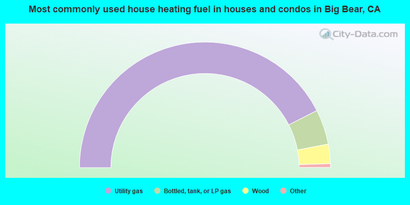
- 85.0%Utility gas
- 9.0%Bottled, tank, or LP gas
- 5.0%Wood
- 0.9%Electricity
- 0.1%Fuel oil, kerosene, etc.
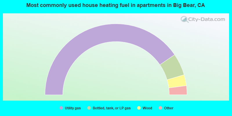
- 80.9%Utility gas
- 10.0%Bottled, tank, or LP gas
- 5.0%Wood
- 3.5%Electricity
- 0.4%Other fuel
- 0.2%No fuel used
Big Bear compared to California state average:
- Unemployed percentage significantly below state average.
- Black race population percentage significantly below state average.
- Hispanic race population percentage significantly below state average.
- Median age significantly above state average.
- Foreign-born population percentage significantly below state average.
- Length of stay since moving in significantly above state average.
- Number of rooms per house significantly below state average.
- House age significantly below state average.
Big Bear on our top lists:
- #3 on the list of "Top 101 cities with the largest percentage of one, detached housing units in structures (20,000+ housing units)"
- #23 on the list of "Top 101 cities with largest percentage of males in occupations: therapists (population 5,000+)"
- #29 on the list of "Top 101 cities with largest percentage of females in industries: furniture and home furnishings, and household appliance stores (population 5,000+)"
- #30 on the list of "Top 100 highest located cities (pop. 5,000+)"
- #42 on the list of "Top 101 cities with largest percentage of males in occupations: information and record clerks except customer service representatives (population 5,000+)"
- #54 on the list of "Top 101 cities with largest percentage of males in occupations: preschool, kindergarten, elementary and middle school teachers (population 5,000+)"
- #56 on the list of "Top 101 cities with largest percentage of females in occupations: other management occupations except farmers and farm managers (population 5,000+)"
- #56 on the list of "Top 101 cities with the largest percentage of people in other workers' dormitories (population 1,000+)"
- #65 on the list of "Top 101 cities with largest percentage of females in occupations: waiters and waitresses (population 5,000+)"
- #78 on the list of "Top 101 cities with largest percentage of females in occupations: information and record clerks except customer service representatives (population 5,000+)"
- #80 on the list of "Top 101 cities with largest percentage of females in industries: farm supplies merchant wholesalers (population 5,000+)"
- #95 on the list of "Top 100 cities with largest land areas (pop. 5,000+)"
- #5 on the list of "Top 101 counties with the highest Nitrogen Dioxide air pollution readings in 2012 (ppm)"
- #5 on the list of "Top 101 counties with the highest ground withdrawal of fresh water for public supply"
- #10 on the list of "Top 101 counties with the most Evangelical Protestant congregations"
- #14 on the list of "Top 101 counties with the highest total withdrawal of fresh water for public supply"
- #15 on the list of "Top 101 counties with the most Evangelical Protestant adherents (pop. 50,000+)"

|
Total of 2 patent applications in 2008-2024.