New Lebanon, Ohio
Submit your own pictures of this village and show them to the world
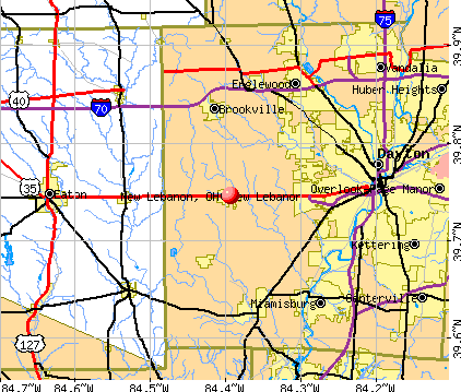
- OSM Map
- General Map
- Google Map
- MSN Map
Population change since 2000: -10.7%
 |
| Males: 1,685 | |
| Females: 2,095 |
| Median resident age: | 33.2 years |
| Ohio median age: | 39.9 years |
Zip codes: 45345.
| New Lebanon: | $60,118 |
| OH: | $65,720 |
Estimated per capita income in 2022: $24,464 (it was $16,718 in 2000)
New Lebanon village income, earnings, and wages data
Estimated median house or condo value in 2022: $111,009 (it was $84,200 in 2000)
| New Lebanon: | $111,009 |
| OH: | $204,100 |
Mean prices in 2022: all housing units: $129,318; detached houses: $129,450
Median gross rent in 2022: $864.
(31.8% for White Non-Hispanic residents, 17.9% for two or more races residents)
Detailed information about poverty and poor residents in New Lebanon, OH
Compare current foreclosures near New Lebanon, OH:
| Photo | Address | Area | Beds / Baths | Price | Details |
|---|---|---|---|---|---|

|
#1
S Lutheran Church Rd
New Lebanon, OH 45345
|
1,640 sq. feet
|
1 baths 2 beds |
show details | |

|
#2
Crawford Rd
New Lebanon, OH 45345
|
1,248 sq. feet
|
1 baths 3 beds |
show details | |

|
#3
Gloria Ave
New Lebanon, OH 45345
|
1,803 sq. feet
|
2 baths 3 beds |
show details | |

|
#4
Yale Ave
New Lebanon, OH 45345
|
1,160 sq. feet
|
1 baths 3 beds |
show details | |

|
#5
Lawson Ave
New Lebanon, OH 45345
|
864 sq. feet
|
1 baths 3 beds |
show details | |

|
#6
Mile Rd
New Lebanon, OH 45345
|
3,293 sq. feet
|
2 baths 4 beds |
show details | |

|
#7
Eaton Pike
New Lebanon, OH 45345
|
- sq. feet
|
- baths - beds |
show details | |

|
#8
Traction Ave
New Lebanon, OH 45345
|
- sq. feet
|
- baths - beds |
show details | |

|
#9
Milestone Park
New Lebanon, OH 45345
|
- sq. feet
|
- baths - beds |
show details | |

|
#10
S Clayton Rd Lot 14
New Lebanon, OH 45345
|
- sq. feet
|
- baths - beds |
show details |
| Photo | Address | Area | Beds / Baths | Price | Details |
|---|---|---|---|---|---|

|
#11
S Sulphur Springs Rd
New Lebanon, OH 45345
|
- sq. feet
|
- baths - beds |
show details | |

|
#12
Sparks St
Dayton, OH 45426
|
1,100 sq. feet
|
1 baths 3 beds |
$159,900
|
show details |

|
#13
Alexandersville Bell
Dayton, OH 45449
|
1,669 sq. feet
|
2 baths 3 beds |
$148,500
|
show details |

|
#14
W Main St
New Lebanon, OH 45345
|
- sq. feet
|
- baths - beds |
show details | |

|
#15
Clayton Ave
Middletown, OH 45042
|
- sq. feet
|
1 baths 2 beds |
$65,100
|
show details |

|
#16
Edison St
Dayton, OH 45417
|
1,217 sq. feet
|
1 baths 2 beds |
show details | |

|
#17
Pepper Dr
Dayton, OH 45424
|
1,155 sq. feet
|
2 baths 4 beds |
show details | |

|
#18
Lakeview Ave
Dayton, OH 45417
|
1,290 sq. feet
|
2 baths 3 beds |
show details | |

|
#19
Quinn Rd
West Alexandria, OH 45381
|
1,512 sq. feet
|
1 baths 3 beds |
show details | |

|
#20
Forest Ridge Blvd
Dayton, OH 45424
|
1,898 sq. feet
|
2 baths 4 beds |
show details |
| Photo | Address | Area | Beds / Baths | Price | Details |
|---|---|---|---|---|---|

|
#21
520 Cherry St
Eaton, OH 45320
|
903 sq. feet
|
1 baths 1 beds |
show details | |

|
#22
Xenia Ave
Dayton, OH 45410
|
1,796 sq. feet
|
1 baths 3 beds |
show details | |

|
#23
Parrot St
Dayton, OH 45410
|
- sq. feet
|
- baths - beds |
$9,750
|
show details |

|
#24
E Lindsey Ave
Miamisburg, OH 45342
|
1,161 sq. feet
|
1 baths 3 beds |
show details | |

|
#25
S Garfield St
Dayton, OH 45403
|
1,536 sq. feet
|
1 baths 2 beds |
show details | |

|
#26
Willowwood Dr
Dayton, OH 45405
|
1,992 sq. feet
|
2 baths 4 beds |
show details | |

|
#27
Sandpiper Ln
Dayton, OH 45424
|
2,088 sq. feet
|
2 baths 4 beds |
show details | |

|
#28
Westwood Ave
Dayton, OH 45417
|
1,495 sq. feet
|
1 baths 2 beds |
show details | |

|
#29
Kley Rd
Vandalia, OH 45377
|
1,020 sq. feet
|
1 baths 1 beds |
show details | |

|
#30
Saxony Rd
Miamisburg, OH 45342
|
944 sq. feet
|
1 baths 1 beds |
show details |
| Photo | Address | Area | Beds / Baths | Price | Details |
|---|---|---|---|---|---|

|
#31
E Bruce Ave
Dayton, OH 45405
|
1,470 sq. feet
|
2 baths 3 beds |
show details | |

|
#32
Hackett Dr
Dayton, OH 45417
|
1,185 sq. feet
|
1 baths 3 beds |
show details | |

|
#33
Glenbrook Dr
Dayton, OH 45406
|
1,333 sq. feet
|
2 baths 3 beds |
show details | |

|
#34
E Market St
Germantown, OH 45327
|
1,248 sq. feet
|
1 baths 3 beds |
show details | |

|
#35
W 2nd St
Dayton, OH 45402
|
1,784 sq. feet
|
1 baths 3 beds |
show details | |

|
#36
Cheviot Hills Ln
Vandalia, OH 45377
|
3,096 sq. feet
|
3 baths 3 beds |
show details | |

|
#37
Anderson St
Franklin, OH 45005
|
1,284 sq. feet
|
1 baths 2 beds |
show details | |

|
#38
Franlou Ave
Dayton, OH 45432
|
1,155 sq. feet
|
1 baths 4 beds |
show details | |

|
#39
Malvern Ave
Dayton, OH 45406
|
1,676 sq. feet
|
1 baths 5 beds |
show details | |

|
#40
Dorf Dr
Dayton, OH 45439
|
1,066 sq. feet
|
2 baths 3 beds |
show details |
| Photo | Address | Area | Beds / Baths | Price | Details |
|---|---|---|---|---|---|

|
#41
Bingham Ave
Dayton, OH 45420
|
912 sq. feet
|
1 baths 3 beds |
show details | |

|
#42
Merrywood Dr
Englewood, OH 45322
|
1,827 sq. feet
|
2 baths 4 beds |
show details | |

|
#43
Villa Pointe Dr
Springboro, OH 45066
|
1,306 sq. feet
|
2 baths 2 beds |
show details | |

|
#44
Cory Dr
Dayton, OH 45406
|
1,922 sq. feet
|
1 baths 3 beds |
show details | |

|
#45
Ridgebury Dr
Dayton, OH 45440
|
1,120 sq. feet
|
1 baths 3 beds |
show details | |

|
#46
Wilbraham Rd
Middletown, OH 45042
|
1,361 sq. feet
|
1 baths 3 beds |
show details | |

|
#47
Blackhawk Rd
Dayton, OH 45420
|
1,050 sq. feet
|
1 baths 3 beds |
show details | |

|
#48
Upper Miamisburg Rd
Miamisburg, OH 45342
|
1,945 sq. feet
|
2 baths 3 beds |
show details | |

|
#49
Nowak Ave
Dayton, OH 45424
|
2,122 sq. feet
|
2 baths 4 beds |
show details | |

|
Check over 1 million property listings on Foreclosure.com!
|
browse all offers | |||


- 3,82693.0%White alone
- 1704.1%Two or more races
- 521.3%Black alone
- 421.0%Asian alone
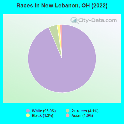
Races in New Lebanon detailed stats: ancestries, foreign born residents, place of birth
According to our research of Ohio and other state lists, there were 13 registered sex offenders living in New Lebanon, Ohio as of May 03, 2024.
The ratio of all residents to sex offenders in New Lebanon is 317 to 1.
Type |
2009 |
2010 |
2011 |
2012 |
2013 |
2014 |
2015 |
2016 |
2017 |
2018 |
2019 |
2020 |
2021 |
2022 |
|---|---|---|---|---|---|---|---|---|---|---|---|---|---|---|
| Murders (per 100,000) | 0 (0.0) | 0 (0.0) | 0 (0.0) | 0 (0.0) | 0 (0.0) | 0 (0.0) | 0 (0.0) | 0 (0.0) | 0 (0.0) | 0 (0.0) | 0 (0.0) | 0 (0.0) | 0 (0.0) | 0 (0.0) |
| Rapes (per 100,000) | 1 (24.5) | 1 (25.0) | 3 (75.0) | 4 (99.7) | 0 (0.0) | 1 (25.1) | 1 (25.1) | 0 (0.0) | 2 (50.4) | 0 (0.0) | 1 (25.0) | 2 (50.2) | 3 (75.2) | 3 (79.3) |
| Robberies (per 100,000) | 3 (73.4) | 2 (50.1) | 0 (0.0) | 0 (0.0) | 0 (0.0) | 2 (50.2) | 1 (25.1) | 2 (50.0) | 4 (100.9) | 0 (0.0) | 0 (0.0) | 1 (25.1) | 0 (0.0) | 1 (26.4) |
| Assaults (per 100,000) | 2 (49.0) | 4 (100.1) | 1 (25.0) | 2 (49.8) | 1 (25.1) | 0 (0.0) | 4 (100.4) | 7 (175.0) | 4 (100.9) | 6 (150.6) | 2 (50.0) | 2 (50.2) | 6 (150.5) | 12 (317.4) |
| Burglaries (per 100,000) | 38 (930.2) | 46 (1,151) | 30 (750.4) | 27 (672.8) | 45 (1,127) | 41 (1,028) | 26 (652.3) | 26 (649.8) | 22 (554.7) | 22 (552.3) | 11 (274.9) | 15 (376.6) | 6 (150.5) | 5 (132.2) |
| Thefts (per 100,000) | 85 (2,081) | 87 (2,178) | 84 (2,101) | 84 (2,093) | 100 (2,505) | 78 (1,956) | 56 (1,405) | 79 (1,975) | 70 (1,765) | 76 (1,908) | 39 (974.8) | 46 (1,155) | 16 (401.2) | 30 (793.4) |
| Auto thefts (per 100,000) | 11 (269.3) | 2 (50.1) | 24 (600.3) | 14 (348.9) | 4 (100.2) | 6 (150.5) | 2 (50.2) | 11 (274.9) | 3 (75.6) | 6 (150.6) | 4 (100.0) | 3 (75.3) | 0 (0.0) | 1 (26.4) |
| Arson (per 100,000) | 0 (0.0) | 0 (0.0) | 0 (0.0) | 0 (0.0) | 2 (50.1) | 2 (50.2) | 0 (0.0) | 0 (0.0) | 1 (25.2) | 0 (0.0) | 1 (25.0) | 2 (50.2) | 1 (25.1) | 1 (26.4) |
| City-Data.com crime index | 221.3 | 226.8 | 249.6 | 248.4 | 192.1 | 197.4 | 153.5 | 196.5 | 206.3 | 157.2 | 96.2 | 136.3 | 116.9 | 178.0 |
The City-Data.com crime index weighs serious crimes and violent crimes more heavily. Higher means more crime, U.S. average is 246.1. It adjusts for the number of visitors and daily workers commuting into cities.
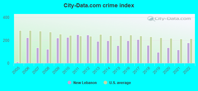
Crime rate in New Lebanon detailed stats: murders, rapes, robberies, assaults, burglaries, thefts, arson
Full-time law enforcement employees in 2010, including police officers: 8 (8 officers - 6 male; 2 female).
| Officers per 1,000 residents here: | 2.00 |
| Ohio average: | 2.11 |
 Recent articles from our blog. Our writers, many of them Ph.D. graduates or candidates, create easy-to-read articles on a wide variety of topics.

 | Dayton "Midtown District" Plan (162 replies) |
| What if I-675 were completed all the way around Dayton??? (48 replies) |
| Moving to the Dayton Area (13 replies) |
| Dayton limping (63 replies) |
| moving from INdy.. for a job at Dayton International Airport (23 replies) |
| Interview in Dayton Coming Up (11 replies) |
Latest news from New Lebanon, OH collected exclusively by city-data.com from local newspapers, TV, and radio stations
Ancestries: German (32.9%), American (18.1%), Irish (14.4%), English (10.2%), Polish (5.1%), Welsh (1.3%).
Current Local Time: EST time zone
Incorporated in 1978
Elevation: 910 feet
Land area: 2.00 square miles.
Population density: 1,891 people per square mile (low).
39 residents are foreign born
| This village: | 0.9% |
| Ohio: | 4.9% |
Median real estate property taxes paid for housing units with mortgages in 2022: $2,311 (2.0%)
Median real estate property taxes paid for housing units with no mortgage in 2022: $1,995 (1.9%)
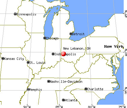
Nearest city with pop. 50,000+: Dayton, OH  (10.5 miles , pop. 166,179).
Nearest city with pop. 200,000+: Cincinnati, OH (42.6 miles , pop. 331,285).
Nearest city with pop. 1,000,000+: Chicago, IL (224.9 miles , pop. 2,896,016).
Nearest cities:
), ), ), ), )Latitude: 39.75 N, Longitude: 84.39 W
Area code: 937
New Lebanon, Ohio accommodation & food services, waste management - Economy and Business Data
Single-family new house construction building permits:
- 1997: 1 building, cost: $60,000
| Here: | 3.3% |
| Ohio: | 3.1% |
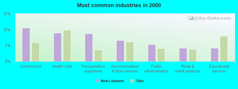
- Construction (10.5%)
- Health care (9.0%)
- Transportation equipment (8.8%)
- Accommodation & food services (6.6%)
- Public administration (5.3%)
- Metal & metal products (4.2%)
- Educational services (4.2%)
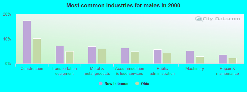
- Construction (17.4%)
- Transportation equipment (7.2%)
- Metal & metal products (7.0%)
- Accommodation & food services (6.3%)
- Public administration (5.7%)
- Machinery (5.2%)
- Repair & maintenance (3.6%)
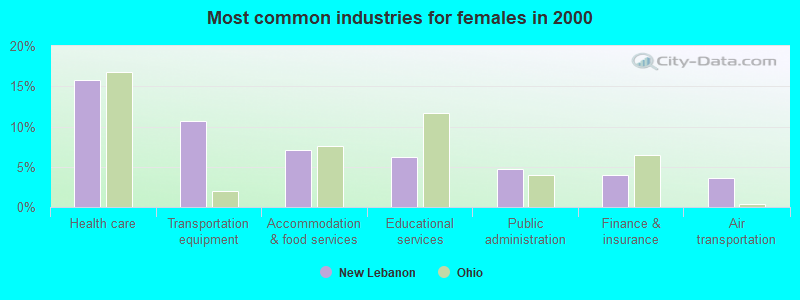
- Health care (15.8%)
- Transportation equipment (10.7%)
- Accommodation & food services (7.1%)
- Educational services (6.3%)
- Public administration (4.8%)
- Finance & insurance (3.9%)
- Air transportation (3.6%)
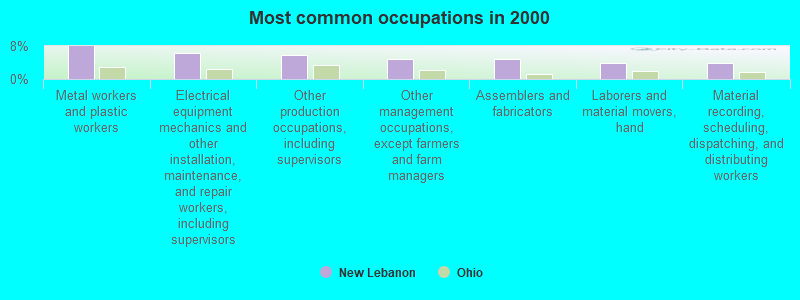
- Metal workers and plastic workers (7.9%)
- Electrical equipment mechanics and other installation, maintenance, and repair workers, including supervisors (6.4%)
- Other production occupations, including supervisors (5.8%)
- Other management occupations, except farmers and farm managers (4.9%)
- Assemblers and fabricators (4.8%)
- Laborers and material movers, hand (4.0%)
- Material recording, scheduling, dispatching, and distributing workers (3.8%)
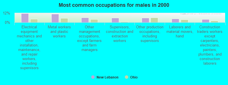
- Electrical equipment mechanics and other installation, maintenance, and repair workers, including supervisors (11.7%)
- Metal workers and plastic workers (10.9%)
- Other management occupations, except farmers and farm managers (6.2%)
- Supervisors, construction and extraction workers (5.9%)
- Other production occupations, including supervisors (5.9%)
- Laborers and material movers, hand (4.7%)
- Construction traders workers except carpenters, electricians, painters, plumbers, and construction laborers (4.2%)
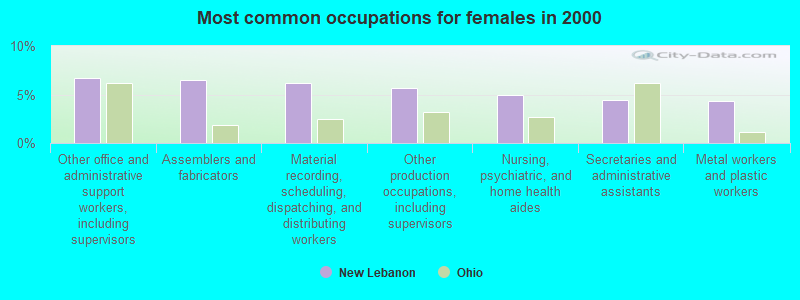
- Other office and administrative support workers, including supervisors (6.7%)
- Assemblers and fabricators (6.5%)
- Material recording, scheduling, dispatching, and distributing workers (6.2%)
- Other production occupations, including supervisors (5.7%)
- Nursing, psychiatric, and home health aides (5.0%)
- Secretaries and administrative assistants (4.4%)
- Metal workers and plastic workers (4.3%)
Average climate in New Lebanon, Ohio
Based on data reported by over 4,000 weather stations


|
|

(lower is better)
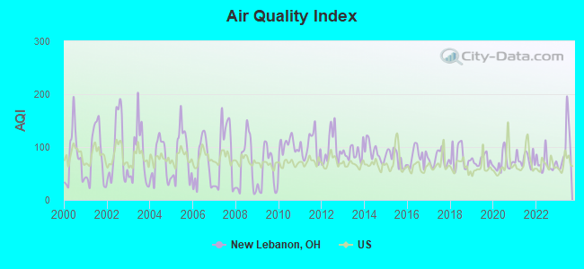
Air Quality Index (AQI) level in 2023 was 98.8. This is worse than average.
| City: | 98.8 |
| U.S.: | 72.6 |
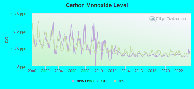
Carbon Monoxide (CO) [ppm] level in 2023 was 0.169. This is significantly better than average. Closest monitor was 9.4 miles away from the city center.
| City: | 0.169 |
| U.S.: | 0.251 |
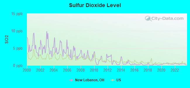
Sulfur Dioxide (SO2) [ppb] level in 2023 was 0.405. This is significantly better than average. Closest monitor was 7.5 miles away from the city center.
| City: | 0.405 |
| U.S.: | 1.515 |
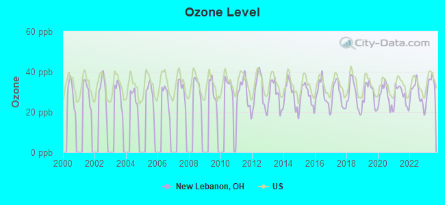
Ozone [ppb] level in 2023 was 32.9. This is about average. Closest monitor was 8.9 miles away from the city center.
| City: | 32.9 |
| U.S.: | 33.3 |
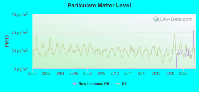
Particulate Matter (PM10) [µg/m3] level in 2023 was 20.9. This is about average. Closest monitor was 7.5 miles away from the city center.
| City: | 20.9 |
| U.S.: | 19.2 |
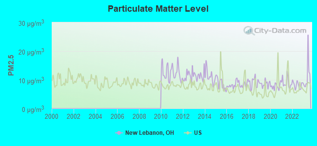
Particulate Matter (PM2.5) [µg/m3] level in 2023 was 11.4. This is significantly worse than average. Closest monitor was 10.4 miles away from the city center.
| City: | 11.4 |
| U.S.: | 8.1 |
Tornado activity:
New Lebanon-area historical tornado activity is slightly above Ohio state average. It is 70% greater than the overall U.S. average.
On 4/3/1974, a category F5 (max. wind speeds 261-318 mph) tornado 20.0 miles away from the New Lebanon village center killed 36 people and injured 1150 people and caused between $50,000,000 and $500,000,000 in damages.
On 4/25/1961, a category F4 (max. wind speeds 207-260 mph) tornado 12.0 miles away from the village center injured 7 people and caused between $500,000 and $5,000,000 in damages.
Earthquake activity:
New Lebanon-area historical earthquake activity is significantly above Ohio state average. It is 31% greater than the overall U.S. average.On 7/27/1980 at 18:52:21, a magnitude 5.2 (5.1 MB, 4.7 MS, 5.0 UK, 5.2 UK, Class: Moderate, Intensity: VI - VII) earthquake occurred 109.3 miles away from the city center
On 4/18/2008 at 09:36:59, a magnitude 5.4 (5.1 MB, 4.8 MS, 5.4 MW, 5.2 MW) earthquake occurred 207.7 miles away from New Lebanon center
On 7/12/1986 at 08:19:37, a magnitude 4.5 (4.5 MB, Class: Light, Intensity: IV - V) earthquake occurred 54.7 miles away from the city center
On 4/18/2008 at 09:36:59, a magnitude 5.2 (5.2 MW, Depth: 8.9 mi) earthquake occurred 207.7 miles away from the city center
On 6/10/1987 at 23:48:54, a magnitude 5.1 (4.9 MB, 4.4 MS, 4.6 MS, 5.1 LG) earthquake occurred 197.5 miles away from New Lebanon center
On 9/7/1988 at 02:28:09, a magnitude 4.6 (4.5 MB, 4.6 LG) earthquake occurred 114.3 miles away from the city center
Magnitude types: regional Lg-wave magnitude (LG), body-wave magnitude (MB), surface-wave magnitude (MS), moment magnitude (MW)
Natural disasters:
The number of natural disasters in Montgomery County (9) is smaller than the US average (15).Major Disasters (Presidential) Declared: 4
Emergencies Declared: 3
Causes of natural disasters: Floods: 4, Storms: 3, Mudslides: 2, Winds: 2, Blizzard: 1, Heavy Rain: 1, Hurricane: 1, Landslide: 1, Snow: 1, Snowstorm: 1, Tornado: 1, Tropical Depression: 1, Winter Storm: 1, Other: 1 (Note: some incidents may be assigned to more than one category).

Hospitals and medical centers in New Lebanon:
Airports located in New Lebanon:
- Green Acres Airport (06OI) (Runways: 1, Itinerant Ops: 30, Local Ops: 200)
- Stone Airport (1OI6) (Runways: 1)
Colleges/universities with over 2000 students nearest to New Lebanon:
- Sinclair Community College (about 11 miles; Dayton, OH; Full-time enrollment: 13,779)
- University of Dayton (about 12 miles; Dayton, OH; FT enrollment: 10,392)
- Fortis College-Centerville (about 15 miles; Centerville, OH; FT enrollment: 4,527)
- Wright State University-Main Campus (about 18 miles; Dayton, OH; FT enrollment: 14,482)
- Miami University-Oxford (about 25 miles; Oxford, OH; FT enrollment: 17,670)
- Miami University-Hamilton (about 28 miles; Hamilton, OH; FT enrollment: 2,906)
- Indiana University-East (about 28 miles; Richmond, IN; FT enrollment: 2,867)
Public high school in New Lebanon:
- DIXIE HIGH SCHOOL (Students: 367, Location: 300 S FULS RD, Grades: 9-12)
Public elementary/middle schools in New Lebanon:
- DIXIE ELEMENTARY SCHOOL (Students: 428, Location: 1150 W MAIN ST, Grades: PK-4)
- DIXIE MIDDLE SCHOOL (Students: 348, Location: 200 S FULS RD, Grades: 5-8)
Points of interest:
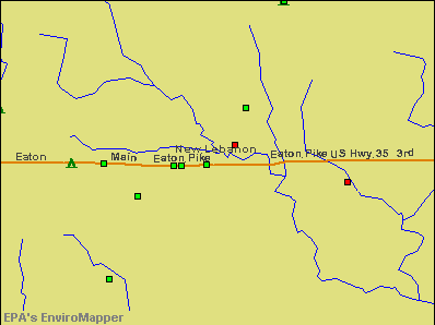
Notable location: New Lebanon Fire Department Station 69 (A). Display/hide its location on the map
Churches in New Lebanon include: Brethren Church (A), First Baptist Church of New Lebanon (B), Trinity United Church of Christ (C), New Lebanon United Methodist Church (D), New Lebanon Church of Christ (E). Display/hide their locations on the map
Streams, rivers, and creeks: Diehl Run (A). Display/hide its location on the map
Park in New Lebanon: Jones Park (1). Display/hide its location on the map
Birthplace of: Gary Gearhart - Baseball player.
| This village: | 2.5 people |
| Ohio: | 2.4 people |
| This village: | 69.2% |
| Whole state: | 65.0% |
| This village: | 6.9% |
| Whole state: | 6.8% |
Likely homosexual households (counted as self-reported same-sex unmarried-partner households)
- Lesbian couples: 0.3% of all households
- Gay men: 0.1% of all households
118 people in nursing homes in 2000
Banks with branches in New Lebanon (2011 data):
- KeyBank National Association: New Lebanon Branch at 47 West Main Street, branch established on 1931/01/01. Info updated 2008/03/03: Bank assets: $86,198.8 mil, Deposits: $64,214.8 mil, headquarters in Cleveland, OH, positive income, Commercial Lending Specialization, 1067 total offices, Holding Company: Keycorp
- Advantage Bank: New Lebanon Branch at 675 West Main Street, branch established on 1887/01/01. Info updated 2011/03/23: Bank assets: $767.1 mil, Deposits: $634.2 mil, headquarters in Cambridge, OH, positive income, Commercial Lending Specialization, 26 total offices, Holding Company: Camco Financial Corporation
For population 15 years and over in New Lebanon:
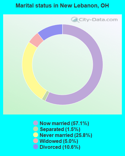
- Never married: 25.8%
- Now married: 57.1%
- Separated: 1.5%
- Widowed: 5.0%
- Divorced: 10.6%
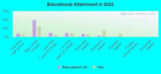
For population 25 years and over in New Lebanon:
- High school or higher: 88.4%
- Bachelor's degree or higher: 5.6%
- Graduate or professional degree: 1.1%
- Unemployed: 5.6%
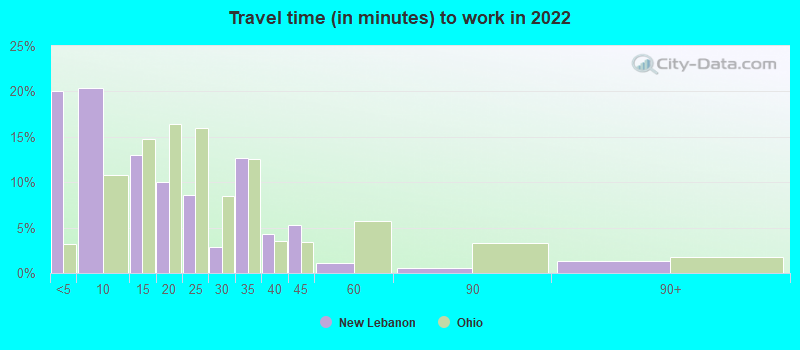
- Mean travel time to work (commute): 25.6 minutes
| Here: | 9.3 |
| Ohio average: | 11.0 |
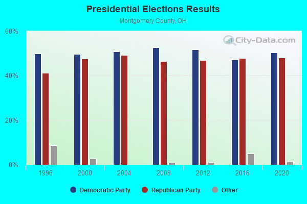
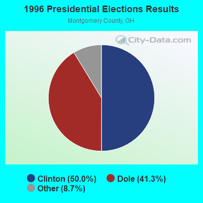
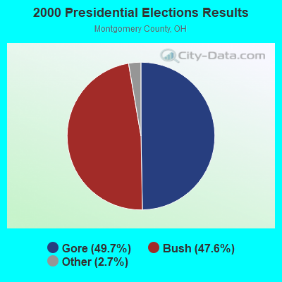
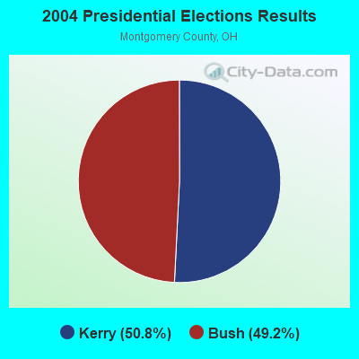
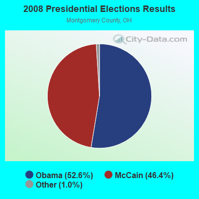

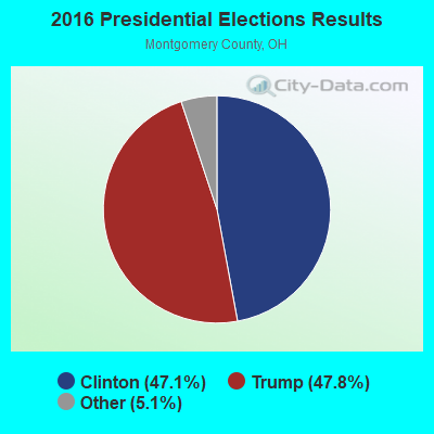
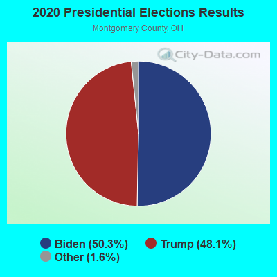
Graphs represent county-level data. Detailed 2008 Election Results
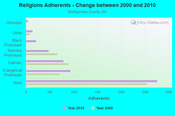
Religion statistics for New Lebanon, OH (based on Montgomery County data)
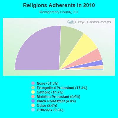
| Religion | Adherents | Congregations |
|---|---|---|
| Evangelical Protestant | 93,334 | 306 |
| Catholic | 78,909 | 34 |
| Mainline Protestant | 47,961 | 143 |
| Black Protestant | 21,263 | 56 |
| Other | 14,123 | 41 |
| Orthodox | 4,205 | 3 |
| None | 275,358 | - |
Food Environment Statistics:
| Montgomery County: | 1.52 / 10,000 pop. |
| State: | 1.89 / 10,000 pop. |
| Here: | 0.15 / 10,000 pop. |
| Ohio: | 0.13 / 10,000 pop. |
| This county: | 1.39 / 10,000 pop. |
| Ohio: | 1.25 / 10,000 pop. |
| This county: | 2.31 / 10,000 pop. |
| State: | 2.93 / 10,000 pop. |
| Montgomery County: | 5.76 / 10,000 pop. |
| State: | 6.25 / 10,000 pop. |
| Montgomery County: | 11.0% |
| State: | 10.3% |
| Here: | 30.5% |
| State: | 29.1% |
| Montgomery County: | 9.3% |
| Ohio: | 11.9% |
Health and Nutrition:
| Here: | 48.5% |
| Ohio: | 50.4% |
| This city: | 44.2% |
| Ohio: | 47.8% |
| New Lebanon: | 30.4 |
| Ohio: | 28.7 |
| This city: | 23.9% |
| Ohio: | 20.6% |
| New Lebanon: | 20.0% |
| Ohio: | 10.4% |
| New Lebanon: | 6.8 |
| State: | 6.8 |
| New Lebanon: | 42.8% |
| Ohio: | 34.3% |
| This city: | 52.7% |
| State: | 57.0% |
| New Lebanon: | 77.4% |
| Ohio: | 79.1% |
More about Health and Nutrition of New Lebanon, OH Residents
| Local government employment and payroll (March 2022) | |||||
| Function | Full-time employees | Monthly full-time payroll | Average yearly full-time wage | Part-time employees | Monthly part-time payroll |
|---|---|---|---|---|---|
| Other Government Administration | 9 | $12,367 | $16,489 | 1 | $537 |
| Police Protection - Officers | 8 | $90,163 | $135,245 | 3 | $1,054 |
| Firefighters | 4 | $25,105 | $75,315 | 12 | $7,495 |
| Financial Administration | 4 | $33,987 | $101,961 | 0 | $0 |
| Parks and Recreation | 2 | $16,647 | $99,882 | 2 | $2,750 |
| Water Supply | 2 | $18,154 | $108,924 | 0 | $0 |
| Sewerage | 2 | $10,188 | $61,128 | 0 | $0 |
| Streets and Highways | 1 | $8,478 | $101,736 | 0 | $0 |
| Judicial and Legal | 0 | $0 | 1 | $681 | |
| Totals for Government | 32 | $215,089 | $80,658 | 19 | $12,517 |
New Lebanon government finances - Expenditure in 2017 (per resident):
- Current Operations - Sewerage: $614,000 ($162.43)
Water Utilities: $456,000 ($120.63)
Police Protection: $306,000 ($80.95)
Regular Highways: $298,000 ($78.84)
Financial Administration: $298,000 ($78.84)
Local Fire Protection: $250,000 ($66.14)
General Public Buildings: $175,000 ($46.30)
- Total Salaries and Wages: $1,300,000 ($343.92)
New Lebanon government finances - Revenue in 2017 (per resident):
- Charges - Sewerage: $828,000 ($219.05)
- Local Intergovernmental - General Local Government Support: $199,000 ($52.65)
Highways: $169,000 ($44.71)
- Revenue - Water Utilities: $418,000 ($110.58)
- State Intergovernmental - General Local Government Support: $42,000 ($11.11)
- Tax - Other License: $1,233,000 ($326.19)
Individual Income: $675,000 ($178.57)
Property: $413,000 ($109.26)
New Lebanon government finances - Cash and Securities in 2017 (per resident):
- Sinking Funds - Cash and Securities: $2,258,000 ($597.35)
5.90% of this county's 2021 resident taxpayers lived in other counties in 2020 ($51,044 average adjusted gross income)
| Here: | 5.90% |
| Ohio average: | 5.68% |
0.06% of residents moved from foreign countries ($588 average AGI)
Montgomery County: 0.06% Ohio average: 0.01%
Top counties from which taxpayers relocated into this county between 2020 and 2021:
| from Greene County, OH | |
| from Warren County, OH | |
| from Miami County, OH |
6.00% of this county's 2020 resident taxpayers moved to other counties in 2021 ($58,304 average adjusted gross income)
| Here: | 6.00% |
| Ohio average: | 5.79% |
0.04% of residents moved to foreign countries ($390 average AGI)
Montgomery County: 0.04% Ohio average: 0.01%
Top counties to which taxpayers relocated from this county between 2020 and 2021:
| to Greene County, OH | |
| to Warren County, OH | |
| to Miami County, OH |
| Businesses in New Lebanon, OH | ||||
| Name | Count | Name | Count | |
|---|---|---|---|---|
| GNC | 1 | Rite Aid | 1 | |
| H&R Block | 1 | UPS | 1 | |
| McDonald's | 1 | |||
Strongest AM radio stations in New Lebanon:
- WLW (700 AM; 50 kW; CINCINNATI, OH; Owner: JACOR BROADCASTING CORPORATION)
- WONE (980 AM; 5 kW; DAYTON, OH; Owner: CITICASTERS LICENSES, L.P.)
- WING (1410 AM; 5 kW; DAYTON, OH)
- WHIO (1290 AM; 5 kW; DAYTON, OH; Owner: CXR HOLDINGS, INC.)
- WSAI (1530 AM; 50 kW; CINCINNATI, OH; Owner: JACOR BROADCASTING CORPORATION)
- WTVN (610 AM; 50 kW; COLUMBUS, OH; Owner: CITICASTERS LICENSES, L.P.)
- WDAO (1210 AM; daytime; 1 kW; DAYTON, OH; Owner: JOHNSON COMMUNICATIONS, INC.)
- WRFD (880 AM; daytime; 23 kW; COLUMBUS-WORTHINGTON, OH; Owner: SALEM MEDIA OF OHIO, INC.)
- WHAS (840 AM; 50 kW; LOUISVILLE, KY; Owner: CLEAR CHANNEL BROADCASTING LICENSES, INC.)
- WOWO (1190 AM; 50 kW; FORT WAYNE, IN; Owner: PATHFINDER COMMUNICATIONS CORPORATION)
- WGNZ (1110 AM; daytime; 2 kW; FAIRBORN, OH; Owner: L&D BROADCASTORS INC.)
- WIBC (1070 AM; 50 kW; INDIANAPOLIS, IN; Owner: EMMIS RADIO LICENSE CORPORATION)
- WPFB (910 AM; 1 kW; MIDDLETOWN, OH)
Strongest FM radio stations in New Lebanon:
- WHKO (99.1 FM; DAYTON, OH; Owner: CXR HOLDINGS, INC.)
- WGTZ (92.9 FM; EATON, OH; Owner: BLUE CHIP BROADCASTING LICENSES, LTD)
- WRNB (92.1 FM; WEST CARROLLTON, OH; Owner: RADIO ONE OF DAYTON LICENSES, LLC)
- WFCJ (93.7 FM; MIAMISBURG, OH; Owner: MIAMI VALLEY CHRISTIAN BROADCASTING ASSOCIATION)
- WLQT (99.9 FM; KETTERING, OH; Owner: CITICASTERS LICENSES, L.P.)
- WMMX (107.7 FM; DAYTON, OH; Owner: CITICASTERS LICENSES, L.P.)
- WTUE (104.7 FM; DAYTON, OH; Owner: CITICASTERS LICENSES, L.P.)
- WDPR (88.1 FM; WEST CARROLLTON, OH; Owner: DAYTON PUBLIC RADIO, INC.)
- WXEG (103.9 FM; BEAVERCREEK, OH; Owner: CITICASTERS LICENSES, L.P.)
- WDKF (94.5 FM; ENGLEWOOD, OH; Owner: CITICASTERS LICENSES, L.P.)
- WPFB-FM (105.9 FM; MIDDLETOWN, OH; Owner: RADIO STATIONS WPAY/WPFB, INC.)
- WMOJ (94.9 FM; FAIRFIELD, OH; Owner: WVAE LICO, INC.)
- WYGY (96.5 FM; LEBANON, OH; Owner: WVAE LICO, INC.)
- WDPS (89.5 FM; DAYTON, OH; Owner: DAYTON CITY SCHOOLS)
- WQRP (89.5 FM; DAYTON, OH; Owner: WQRP FAMILY RADIO, INC.)
- WGRR (103.5 FM; HAMILTON, OH; Owner: INFINITY RADIO OPERATIONS INC.)
- WMUB (88.5 FM; OXFORD, OH; Owner: THE PRES.& TRUSTEES OF MIAMI UNIV.)
- WRRM (98.5 FM; CINCINNATI, OH; Owner: WRRM LICO, INC)
- WFMG (101.3 FM; RICHMOND, IN; Owner: RODGERS BROADCASTING CORP.)
- WAQZ (97.3 FM; FORT THOMAS, KY; Owner: INFINITY RADIO OPERATIONS INC.)
TV broadcast stations around New Lebanon:
- WHIO-TV (Channel 7; DAYTON, OH; Owner: WHIO-TV HOLDINGS, INC.)
- WDTN (Channel 2; DAYTON, OH; Owner: WDTN BROADCASTING, LLC)
- WKEF (Channel 22; DAYTON, OH; Owner: WKEF LICENSEE L.P.)
- WRGT-TV (Channel 45; DAYTON, OH; Owner: WRGT LICENSEE, LLC)
- WPTD (Channel 16; DAYTON, OH; Owner: GREATER DAYTON PUBLIC TV, INC.)
- W61DE (Channel 61; CINCINNATI, OH; Owner: TRINITY BROADCASTING NETWORK)
- WRCX-LP (Channel 51; DAYTON, OH; Owner: ROSS COMMUNICATIONS, LTD.)
- WKOI (Channel 43; RICHMOND, IN; Owner: TRINITY BROADCASTING OF INDIANA, INC.)
- WPTO (Channel 14; OXFORD, OH; Owner: GREATER DAYTON PUBLIC TELEVISION, INC.)
- WBDT (Channel 26; SPRINGFIELD, OH; Owner: ACME TV LICENSES OF OHIO, LLC)
- WWRD-LP (Channel 55; CENTERVILLE, OH; Owner: LIFE BROADCASTING NETWORK)
- WXIX-TV (Channel 19; NEWPORT, KY; Owner: RAYCOM NATIONAL, INC.)
- W66AQ (Channel 66; DAYTON, OH; Owner: WSTR LICENSEE, INC.)
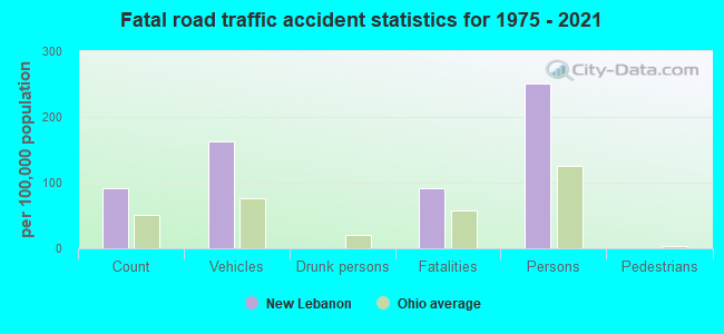
New Lebanon fatal accident list:
Jul 13, 1997 04:27 PM, Bell Lane, Vehicles: 2, Persons: 3, Fatalities: 1
Apr 21, 1983 12:28 AM, Wmain, Vehicles: 2, Persons: 5, Fatalities: 1
Mar 21, 1980 09:55 PM, Vehicles: 1, Persons: 2, Fatalities: 1
- National Bridge Inventory (NBI) Statistics
- 15Number of bridges
- 75ft / 23.4mTotal length
- 16,682Total average daily traffic
- 966Total average daily truck traffic
- 23,066Total future (year 2032) average daily traffic
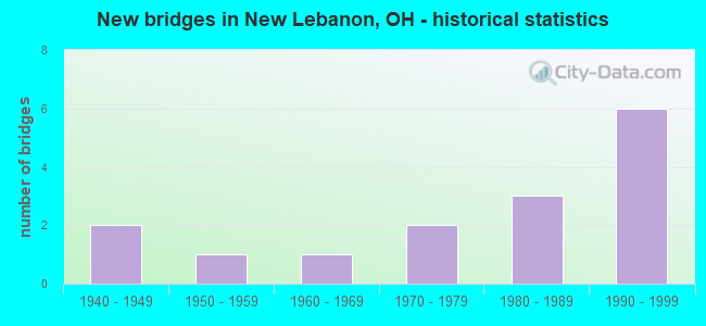
- New bridges - historical statistics
- 21940-1949
- 11950-1959
- 11960-1969
- 21970-1979
- 31980-1989
- 61990-1999
FCC Registered Antenna Towers:
25 (See the full list of FCC Registered Antenna Towers in New Lebanon)FCC Registered Broadcast Land Mobile Towers:
4- 1120 S Lutheran Church Rd (Lat: 39.729500 Lon: -84.347444), Call Sign: KBW334, Licensee ID: L00365728,
Assigned Frequencies: 153.005 MHz, Grant Date: 12/27/2001, Expiration Date: 02/10/2012, Cancellation Date: 04/14/2012, Registrant: Roy Mowen, 5500 S Preble County Line Rd, West Alexandria, OH 45381-9516, Phone: (937) 696-2193
- Lat: 39.744722 Lon: -84.375000, Call Sign: WQHS924,
Assigned Frequencies: 457.675 MHz, 457.975 MHz, 464.662 MHz, 464.887 MHz, 468.337 MHz, Grant Date: 09/09/2017, Expiration Date: 10/29/2027, Certifier: Chuck Sweet, Registrant: P & R Communications Service, Inc., 700 E. First St., Dayton, OH 45402-1383, Phone: (937) 512-8154, Fax: (937) 512-8101, Email:
- Lat: 39.740694 Lon: -84.404639, Call Sign: WQKL594,
Assigned Frequencies: 467.212 MHz, 467.237 MHz, 467.262 MHz, Grant Date: 07/07/2009, Expiration Date: 07/07/2019, Cancellation Date: 09/07/2019, Certifier: Ron E Moore, Registrant: Innovation Wireless, 11869 Teale St, Culver City, CA 90230, Phone: (888) 559-5565
- Lat: 39.740694 Lon: -84.404639, Call Sign: WRJY772,
Assigned Frequencies: 467.212 MHz, 467.237 MHz, 467.262 MHz, Grant Date: 11/21/2020, Expiration Date: 11/21/2030, Certifier: Lance Loop, Registrant: Innovation Wireless, 11869 Teale St, Culver City, CA 90230, Phone: (888) 559-5565
FCC Registered Microwave Towers:
2- New Lebanon OH, 341 N Johnsville-Brkvl Rd (Lat: 39.750000 Lon: -84.423889), Type: Pole, Structure height: 56.1 m, Overall height: 57.6 m, Call Sign: WQIK899,
Assigned Frequencies: 11075.0 MHz, Grant Date: 03/06/2008, Expiration Date: 03/06/2018, Cancellation Date: 09/06/2009, Certifier: William Chastain, Registrant: Radio Dynamics Corporation, Silver Spring, MD 20914, Phone: (301) 493-5171, Fax: (301) 576-4553, Email:
- CVCMH00535B, 301 North Clayton Road (Lat: 39.749417 Lon: -84.395139), Type: Ltower, Structure height: 89.9 m, Overall height: 91.4 m, Call Sign: WRXZ447,
Assigned Frequencies: 10735.0 MHz, 10735.0 MHz, 10735.0 MHz, 10735.0 MHz, 10735.0 MHz, 10735.0 MHz, 10735.0 MHz, 10735.0 MHz, 10735.0 MHz, 10735.0 MHz, 10735.0 MHz, 10735.0 MHz, Grant Date: 07/13/2023, Expiration Date: 07/13/2033, Certifier: Alison A Minea, Registrant: Dish Wireless L.L.C., 9601 S Meridan Blvd, Englewood, CO 80112, Phone: (202) 463-3709, Email:
FCC Registered Amateur Radio Licenses:
39 (See the full list of FCC Registered Amateur Radio Licenses in New Lebanon)FAA Registered Aircraft:
1- Aircraft: PIPER PA-12 (Category: Land, Seats: 3, Weight: Up to 12,499 Pounds, Speed: 82 mph), Engine: LYCOMING 0-235 SERIES (115 HP) (Reciprocating)
N-Number: 245D, N245D, N-245D, Serial Number: 12-2878, Year manufactured: 1947, Airworthiness Date: 07/25/1955, Certificate Issue Date: 03/01/2016
Registrant (Individual): Joshua E Meeks, 14251 Old Dayton Rd, New Lebanon, OH 45345
2002 - 2018 National Fire Incident Reporting System (NFIRS) incidents
- Fire incident types reported to NFIRS in New Lebanon, OH
- 41850.4%Structure Fires
- 32338.9%Outside Fires
- 8710.5%Mobile Property/Vehicle Fires
- 20.2%Other
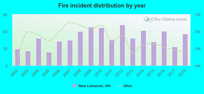 According to the data from the years 2002 - 2018 the average number of fire incidents per year is 49. The highest number of reported fire incidents - 72 took place in 2012, and the least - 24 in 2005. The data has a growing trend.
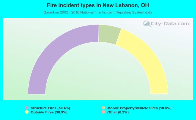 When looking into fire subcategories, the most reports belonged to: Structure Fires (50.4%), and Outside Fires (38.9%).
| Most common first names in New Lebanon, OH among deceased individuals | ||
| Name | Count | Lived (average) |
|---|---|---|
| Mary | 55 | 76.0 years |
| William | 54 | 72.3 years |
| John | 47 | 72.6 years |
| Robert | 46 | 72.7 years |
| James | 42 | 70.1 years |
| Charles | 35 | 73.0 years |
| Ruth | 27 | 80.5 years |
| George | 26 | 77.6 years |
| Helen | 20 | 79.8 years |
| Paul | 17 | 70.6 years |
| Most common last names in New Lebanon, OH among deceased individuals | ||
| Last name | Count | Lived (average) |
|---|---|---|
| Miller | 26 | 78.7 years |
| Smith | 23 | 74.1 years |
| Johnson | 18 | 71.8 years |
| Bowser | 14 | 80.3 years |
| Brown | 13 | 69.4 years |
| Izor | 13 | 73.9 years |
| Davis | 13 | 71.9 years |
| Howard | 11 | 69.2 years |
| Phillips | 11 | 78.8 years |
| Combs | 10 | 71.5 years |
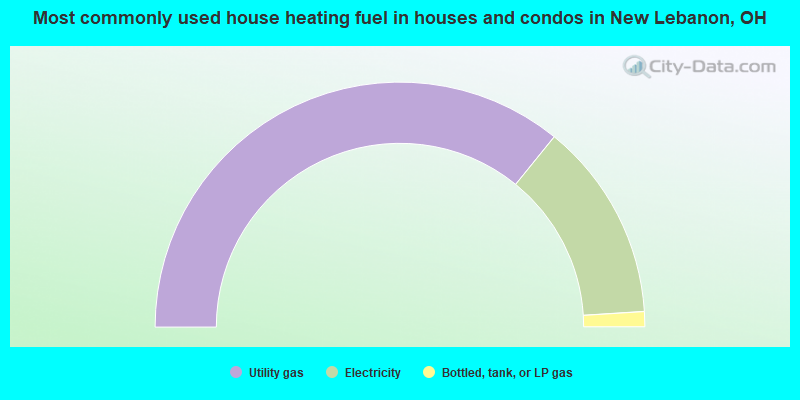
- 71.7%Utility gas
- 26.3%Electricity
- 2.0%Bottled, tank, or LP gas
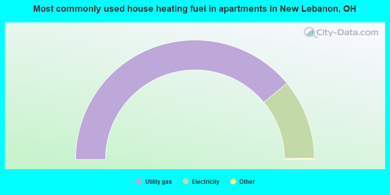
- 78.2%Utility gas
- 21.8%Electricity
New Lebanon compared to Ohio state average:
- Median house value below state average.
- Unemployed percentage below state average.
- Black race population percentage significantly below state average.
- Hispanic race population percentage significantly below state average.
- Foreign-born population percentage significantly below state average.
- Length of stay since moving in significantly above state average.
- Number of college students below state average.
- Percentage of population with a bachelor's degree or higher significantly below state average.

|
Total of 10 patent applications in 2008-2024.