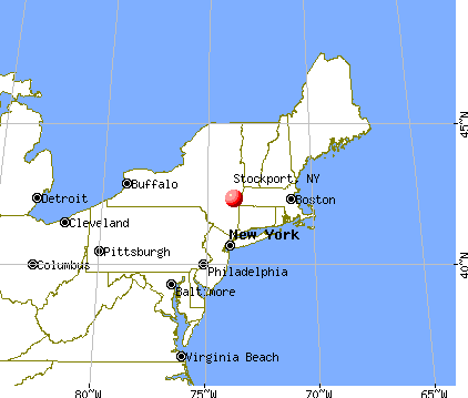
Stockport, New York
Submit your own pictures of this town and show them to the world
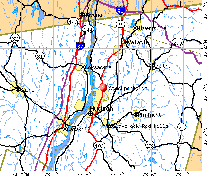
- OSM Map
- General Map
- Google Map
- MSN Map
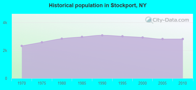
Population change since 2000: -4.0%
 |
| Males: 1,450 | |
| Females: 1,365 |
| Median resident age: | 41.2 years |
| New York median age: | 40.7 years |
Zip codes: 12534.
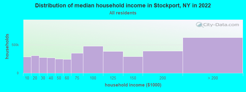
| Stockport: | $80,270 |
| NY: | $79,557 |
Estimated per capita income in 2022: $40,201 (it was $18,137 in 2000)
Stockport town income, earnings, and wages data
Estimated median house or condo value in 2022: $231,645 (it was $87,100 in 2000)
| Stockport: | $231,645 |
| NY: | $400,400 |
Mean prices in 2022: all housing units: $422,433; detached houses: $455,747; townhouses or other attached units: $597,881; in 2-unit structures: $391,116; in 3-to-4-unit structures: $525,972; in 5-or-more-unit structures: over $1,000,000; mobile homes: $85,716
Detailed information about poverty and poor residents in Stockport, NY


- 2,53390.0%White alone
- 1093.9%Black alone
- 893.2%Hispanic
- 592.1%Two or more races
- 200.7%Asian alone
- 30.1%Other race alone
- 10.04%American Indian alone
- 10.04%Native Hawaiian and Other
Pacific Islander alone
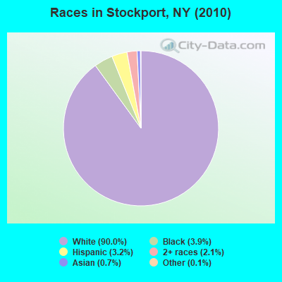
Races in Stockport detailed stats: ancestries, foreign born residents, place of birth
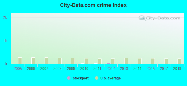
Type |
2009 |
2010 |
2011 |
2012 |
2013 |
2014 |
2015 |
2017 |
2018 |
|---|---|---|---|---|---|---|---|---|---|
| Murders (per 100,000) | 0 (0.0) | 0 (0.0) | 0 (0.0) | 0 (0.0) | 0 (0.0) | 0 (0.0) | 0 (0.0) | 0 (0.0) | 0 (0.0) |
| Rapes (per 100,000) | 0 (0.0) | 0 (0.0) | 0 (0.0) | 0 (0.0) | 0 (0.0) | 0 (0.0) | 0 (0.0) | 0 (0.0) | 0 (0.0) |
| Robberies (per 100,000) | 0 (0.0) | 0 (0.0) | 0 (0.0) | 1 (35.7) | 0 (0.0) | 0 (0.0) | 0 (0.0) | 0 (0.0) | 0 (0.0) |
| Assaults (per 100,000) | 0 (0.0) | 0 (0.0) | 0 (0.0) | 0 (0.0) | 0 (0.0) | 0 (0.0) | 0 (0.0) | 0 (0.0) | 0 (0.0) |
| Burglaries (per 100,000) | 2 (71.5) | 4 (142.1) | 5 (176.8) | 7 (249.6) | 3 (108.7) | 1 (36.4) | 1 (36.6) | 1 (37.6) | 0 (0.0) |
| Thefts (per 100,000) | 3 (107.3) | 9 (319.7) | 9 (318.2) | 2 (71.3) | 2 (72.5) | 0 (0.0) | 2 (73.1) | 2 (75.2) | 7 (264.0) |
| Auto thefts (per 100,000) | 0 (0.0) | 1 (35.5) | 0 (0.0) | 0 (0.0) | 0 (0.0) | 0 (0.0) | 0 (0.0) | 0 (0.0) | 0 (0.0) |
| Arson (per 100,000) | 0 (0.0) | 0 (0.0) | 0 (0.0) | 0 (0.0) | 0 (0.0) | 0 (0.0) | 0 (0.0) | 0 (0.0) | 0 (0.0) |
| City-Data.com crime index | 9.3 | 25.6 | 25.1 | 31.0 | 10.5 | 2.6 | 5.5 | 5.6 | 10.6 |
The City-Data.com crime index weighs serious crimes and violent crimes more heavily. Higher means more crime, U.S. average is 246.1. It adjusts for the number of visitors and daily workers commuting into cities.
Crime rate in Stockport detailed stats: murders, rapes, robberies, assaults, burglaries, thefts, arson
 Recent articles from our blog. Our writers, many of them Ph.D. graduates or candidates, create easy-to-read articles on a wide variety of topics.

 | Outdoor Activity news in Upstate NY (11 replies) |
| Hudson New York, cool or cracked (15 replies) |
| Any Thoughts on Hudson? (17 replies) |
Latest news from Stockport, NY collected exclusively by city-data.com from local newspapers, TV, and radio stations
Ancestries: German (23.2%), Irish (19.1%), Italian (18.1%), English (12.2%), Dutch (9.9%), Polish (8.5%).
Current Local Time: EST time zone
Land area: 11.6 square miles.
Population density: 242 people per square mile (very low).
88 residents are foreign born (2.7% Europe).
| This town: | 3.0% |
| New York: | 20.4% |
| Stockport town: | 2.4% ($2,063) |
| New York: | 1.9% ($2,847) |
Nearest city with pop. 50,000+: Albany, NY  (24.2 miles , pop. 95,658).
Nearest city with pop. 200,000+: Bronx, NY (101.4 miles , pop. 1,332,650).
Nearest cities:
), ), ), )Latitude: 42.31 N, Longitude: 73.75 W
Area code commonly used in this area: 518

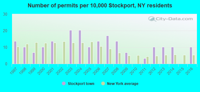
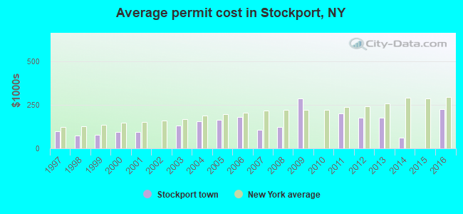
Single-family new house construction building permits:
- 2016: 3 buildings, average cost: $228,300
- 2014: 3 buildings, average cost: $61,700
- 2013: 3 buildings, average cost: $177,000
- 2012: 3 buildings, average cost: $177,000
- 2011: 1 building, cost: $200,000
- 2009: 2 buildings, average cost: $286,500
- 2008: 4 buildings, average cost: $123,800
- 2007: 5 buildings, average cost: $107,000
- 2006: 4 buildings, average cost: $181,300
- 2005: 3 buildings, average cost: $163,300
- 2004: 6 buildings, average cost: $154,500
- 2003: 6 buildings, average cost: $132,200
- 2001: 4 buildings, average cost: $92,900
- 2000: 3 buildings, average cost: $95,300
- 1999: 2 buildings, average cost: $77,500
- 1998: 3 buildings, average cost: $73,700
- 1997: 4 buildings, average cost: $99,600
| Here: | 3.2% |
| New York: | 4.4% |
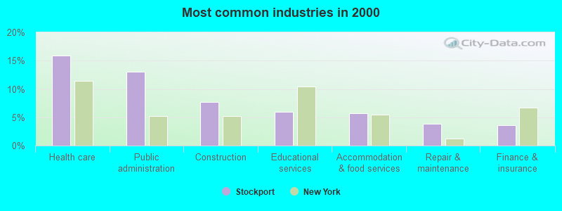
- Health care (15.9%)
- Public administration (13.0%)
- Construction (7.7%)
- Educational services (5.9%)
- Accommodation & food services (5.7%)
- Repair & maintenance (3.9%)
- Finance & insurance (3.7%)
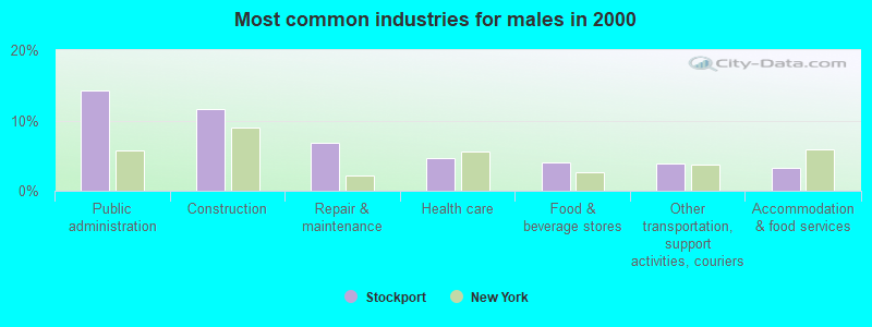
- Public administration (14.3%)
- Construction (11.6%)
- Repair & maintenance (6.8%)
- Health care (4.6%)
- Food & beverage stores (4.1%)
- Other transportation, support activities, couriers (3.8%)
- Accommodation & food services (3.2%)
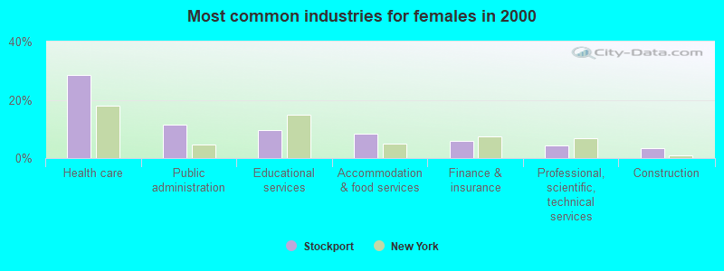
- Health care (28.6%)
- Public administration (11.6%)
- Educational services (9.7%)
- Accommodation & food services (8.4%)
- Finance & insurance (5.8%)
- Professional, scientific, technical services (4.4%)
- Construction (3.3%)
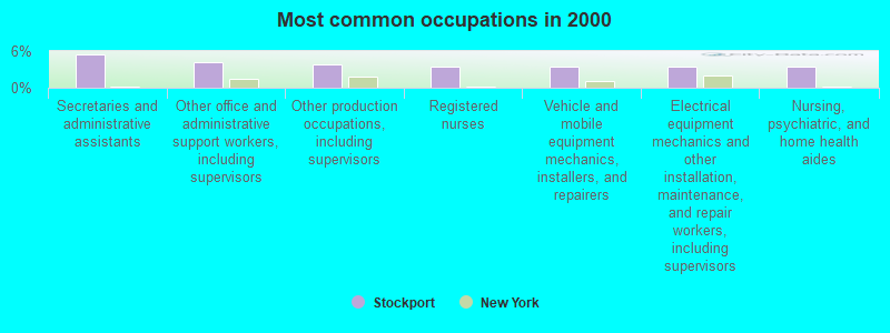
- Secretaries and administrative assistants (5.5%)
- Other office and administrative support workers, including supervisors (4.2%)
- Other production occupations, including supervisors (3.8%)
- Registered nurses (3.5%)
- Vehicle and mobile equipment mechanics, installers, and repairers (3.5%)
- Electrical equipment mechanics and other installation, maintenance, and repair workers, including supervisors (3.5%)
- Nursing, psychiatric, and home health aides (3.5%)
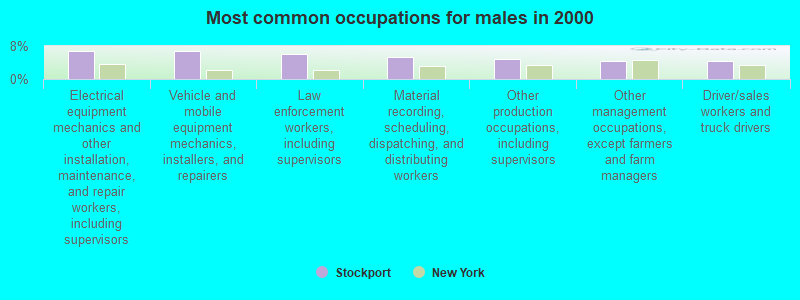
- Electrical equipment mechanics and other installation, maintenance, and repair workers, including supervisors (6.7%)
- Vehicle and mobile equipment mechanics, installers, and repairers (6.7%)
- Law enforcement workers, including supervisors (5.9%)
- Material recording, scheduling, dispatching, and distributing workers (5.3%)
- Other production occupations, including supervisors (5.0%)
- Other management occupations, except farmers and farm managers (4.5%)
- Driver/sales workers and truck drivers (4.5%)
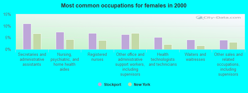
- Secretaries and administrative assistants (11.0%)
- Nursing, psychiatric, and home health aides (7.4%)
- Registered nurses (6.9%)
- Other office and administrative support workers, including supervisors (6.3%)
- Health technologists and technicians (5.2%)
- Waiters and waitresses (4.1%)
- Other sales and related occupations, including supervisors (4.0%)
Average climate in Stockport, New York
Based on data reported by over 4,000 weather stations


(lower is better)
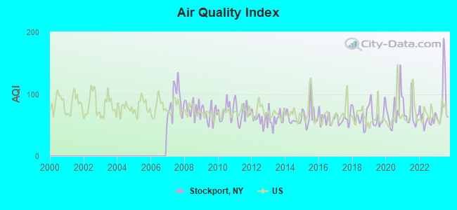
Air Quality Index (AQI) level in 2023 was 86.8. This is about average.
| City: | 86.8 |
| U.S.: | 72.6 |
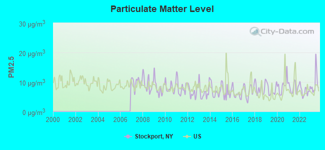
Particulate Matter (PM2.5) [µg/m3] level in 2023 was 9.66. This is about average. Closest monitor was 23.0 miles away from the city center.
| City: | 9.66 |
| U.S.: | 8.11 |
Tornado activity:
Stockport-area historical tornado activity is above New York state average. It is 30% smaller than the overall U.S. average.
On 7/10/1989, a category F4 (max. wind speeds 207-260 mph) tornado 15.1 miles away from the Stockport town center injured 20 people and caused between $5,000,000 and $50,000,000 in damages.
On 5/29/1995, a category F4 tornado 18.1 miles away from the town center killed 3 people and injured 24 people and caused between $5,000,000 and $50,000,000 in damages.
Earthquake activity:
Stockport-area historical earthquake activity is significantly above New York state average. It is 68% smaller than the overall U.S. average.On 10/7/1983 at 10:18:46, a magnitude 5.3 (5.1 MB, 5.3 LG, 5.1 ML, Class: Moderate, Intensity: VI - VII) earthquake occurred 117.5 miles away from the city center
On 4/20/2002 at 10:50:47, a magnitude 5.3 (5.3 ML, Depth: 3.0 mi) earthquake occurred 152.3 miles away from the city center
On 4/20/2002 at 10:50:47, a magnitude 5.2 (5.2 MB, 4.2 MS, 5.2 MW, 5.0 MW) earthquake occurred 150.6 miles away from Stockport center
On 1/19/1982 at 00:14:42, a magnitude 4.7 (4.5 MB, 4.7 MD, 4.5 LG, Class: Light, Intensity: IV - V) earthquake occurred 136.5 miles away from Stockport center
On 8/23/2011 at 17:51:04, a magnitude 5.8 (5.8 MW, Depth: 3.7 mi) earthquake occurred 376.3 miles away from the city center
On 6/17/1991 at 08:53:16, a magnitude 4.1 (4.0 MB, 4.0 LG, Depth: 3.1 mi) earthquake occurred 52.3 miles away from the city center
Magnitude types: regional Lg-wave magnitude (LG), body-wave magnitude (MB), duration magnitude (MD), local magnitude (ML), surface-wave magnitude (MS), moment magnitude (MW)
Natural disasters:
The number of natural disasters in Columbia County (22) is greater than the US average (15).Major Disasters (Presidential) Declared: 12
Emergencies Declared: 9
Causes of natural disasters: Storms: 7, Floods: 6, Hurricanes: 4, Winter Storms: 4, Snowstorms: 3, Blizzards: 2, Power Outage: 1, Tornado: 1, Other: 2 (Note: some incidents may be assigned to more than one category).
Hospitals and medical centers near Stockport:
- COLUMBIA COUNTY CHAPTER NYS ARC, INC (Hospital, about 2 miles away; HUDSON, NY)
- COLUMBIA COUNTY DOH DIVISION OF NRSG CHHA (Home Health Center, about 5 miles away; HUDSON, NY)
- COLUMBIA MEMORIAL HOSPITAL Acute Care Hospitals (about 5 miles away; HUDSON, NY)
- EDEN PARK HEALTH CARE CENTRE INC HUDSON (Nursing Home, about 5 miles away; HUDSON, NY)
- COLUMBIA COUNTY CHAPTER NYS ARC, INC (Hospital, about 9 miles away; VALATIE, NY)
- BARNWELL NURSING AND REHABILITATION CENTER (Nursing Home, about 9 miles away; VALATIE, NY)
- COLUMBIA-GREENE DIALYSIS (CATSKILL DIVISION) (Dialysis Facility, about 9 miles away; CATSKILL, NY)
Amtrak station near Stockport:
Colleges/universities with over 2000 students nearest to Stockport:
- Bard College (about 22 miles; Annandale-On-Hudson, NY; Full-time enrollment: 3,137)
- The College of Saint Rose (about 25 miles; Albany, NY; FT enrollment: 4,085)
- SUNY at Albany (about 27 miles; Albany, NY; FT enrollment: 15,490)
- Hudson Valley Community College (about 27 miles; Troy, NY; FT enrollment: 9,346)
- Excelsior College (about 28 miles; Albany, NY; FT enrollment: 4,723)
- Siena College (about 29 miles; Loudonville, NY; FT enrollment: 3,153)
- The Sage Colleges (about 30 miles; Troy, NY; FT enrollment: 2,499)
Points of interest:
Notable locations in Stockport: Stockport Station (A), Nine-Jay Nursery And Greenhouses (B), Lamphere Dock Post Light (C), Stottville Fire Department (D). Display/hide their locations on the map
Churches in Stockport include: Pentecostal Gospel Lighthouse (A), Holy Family Church (B), Calvary Assembly of God Church (C). Display/hide their locations on the map
Cemeteries: Saint Paul Cemetery (1), Stuyvesant Falls Cemetery (2). Display/hide their locations on the map
Creeks: Widows Creek (A), Fitting Creek (B), Kinderhook Creek (C), Claverack Creek (D), Stockport Creek (E). Display/hide their locations on the map
| This town: | 2.6 people |
| New York: | 2.6 people |
| This town: | 71.1% |
| Whole state: | 63.5% |
| This town: | 11.4% |
| Whole state: | 6.8% |
Likely homosexual households (counted as self-reported same-sex unmarried-partner households)
- Lesbian couples: 0.2% of all households
- Gay men: 0.5% of all households
| This town: | 12.5% |
| Whole state: | 14.6% |
| This town: | 1.8% |
| Whole state: | 7.4% |
10 people in schools, hospitals, or wards for the intellectually disabled in 2000
For population 15 years and over in Stockport:
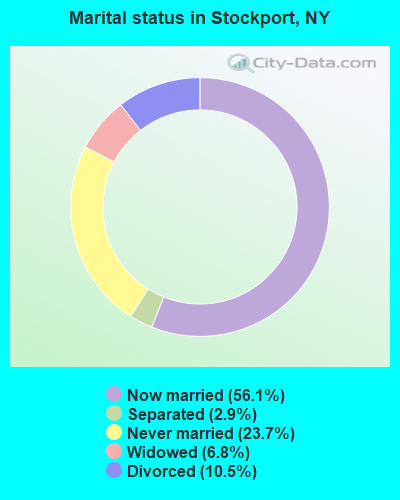
- Never married: 23.7%
- Now married: 56.1%
- Separated: 2.9%
- Widowed: 6.8%
- Divorced: 10.5%
For population 25 years and over in Stockport:
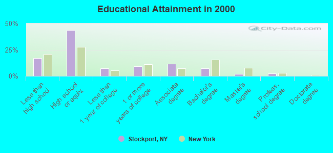
- High school or higher: 83.2%
- Bachelor's degree or higher: 11.3%
- Graduate or professional degree: 4.2%
- Unemployed: 2.5%
- Mean travel time to work (commute): 21.5 minutes
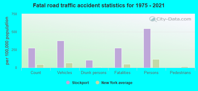
| Here: | 9.8 |
| New York average: | 14.2 |
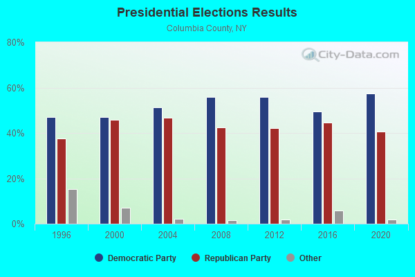
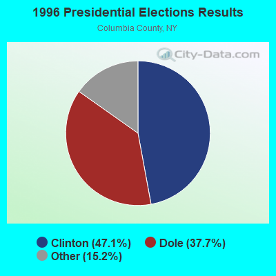
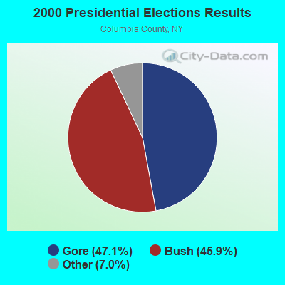
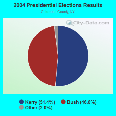
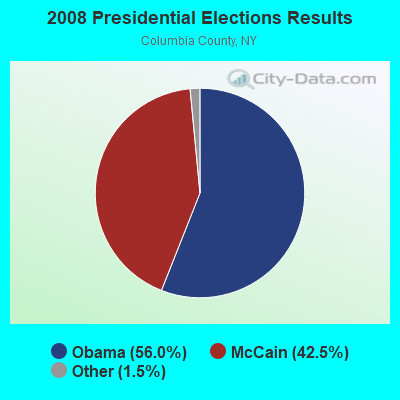

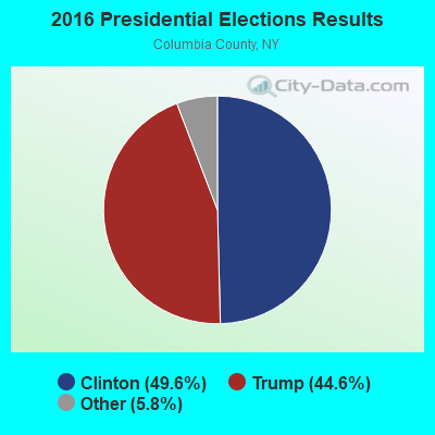
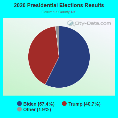
Graphs represent county-level data. Detailed 2008 Election Results
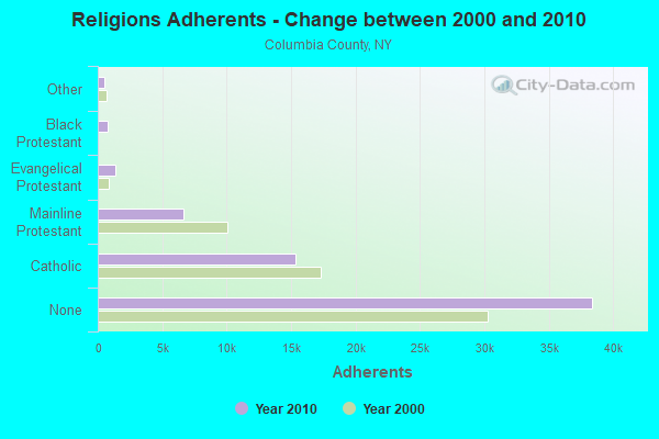
Religion statistics for Stockport, NY (based on Columbia County data)
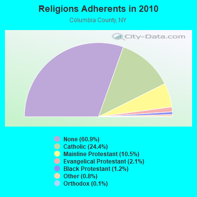
| Religion | Adherents | Congregations |
|---|---|---|
| Catholic | 15,375 | 11 |
| Mainline Protestant | 6,636 | 53 |
| Evangelical Protestant | 1,329 | 16 |
| Black Protestant | 776 | 3 |
| Other | 513 | 7 |
| Orthodox | 70 | 2 |
| None | 38,397 | - |
Food Environment Statistics:
| Columbia County: | 3.54 / 10,000 pop. |
| New York: | 4.13 / 10,000 pop. |
| Columbia County: | 0.80 / 10,000 pop. |
| New York: | 0.92 / 10,000 pop. |
| This county: | 4.98 / 10,000 pop. |
| New York: | 1.68 / 10,000 pop. |
| Here: | 11.09 / 10,000 pop. |
| State: | 8.82 / 10,000 pop. |
| This county: | 8.6% |
| State: | 8.2% |
| Columbia County: | 27.0% |
| New York: | 23.8% |
| Here: | 17.1% |
| New York: | 15.6% |
Strongest AM radio stations in Stockport:
- WHUC (1230 AM; 1 kW; HUDSON, NY; Owner: CLEAR CHANNEL BROADCASTING LICENSES, INC.)
- WGY (810 AM; 50 kW; SCHENECTADY, NY; Owner: CLEAR CHANNEL BROADCASTING LICENSES, INC.)
- WPTR (1540 AM; 50 kW; ALBANY, NY; Owner: KIMTRON, INC.)
- WNNZ (640 AM; 50 kW; WESTFIELD, MA; Owner: CLEAR CHANNEL BROADCASTING LICENSES, INC.)
- WROW (590 AM; 5 kW; ALBANY, NY; Owner: 6 JOHNSON ROAD LICENSES, INC.)
- WTIC (1080 AM; 50 kW; HARTFORD, CT; Owner: INFINITY RADIO OPERATIONS INC.)
- WTMM (1300 AM; 5 kW; RENSSELAER, NY; Owner: REGENT LICENSEE OF MANSFIELD, INC.)
- WDDY (1460 AM; 5 kW; ALBANY, NY)
- WUHN (1110 AM; daytime; 5 kW; PITTSFIELD, MA; Owner: WEINER BROADCASTING, INC.)
- WFAN (660 AM; 50 kW; NEW YORK, NY; Owner: INFINITY BROADCASTING OPERATIONS, INC.)
- WMCA (570 AM; 50 kW; NEW YORK, NY; Owner: SALEM MEDIA OF NEW YORK, LLC)
- WCRN (830 AM; 50 kW; WORCESTER, MA; Owner: CARTER BROADCASTING CORPORATION)
- WSBS (860 AM; 3 kW; GREAT BARRINGTON, MA; Owner: BERKSHIRE BROADCASTING CO., INC.)
Strongest FM radio stations in Stockport:
- WHVP (91.1 FM; HUDSON, NY; Owner: SOUND OF LIFE, INC.)
- WCTW (98.5 FM; CATSKILL, NY; Owner: CLEAR CHANNEL BROADCASTING LICENSES, INC.)
- WAMK (90.9 FM; KINGSTON, NY; Owner: W A M C)
- WFGB (89.7 FM; KINGSTON, NY; Owner: SOUND OF LIFE, INC.)
- WAMQ (105.1 FM; GREAT BARRINGTON, MA; Owner: WAMC)
- WAMC-FM (90.3 FM; ALBANY, NY; Owner: WAMC)
- WAJZ (96.3 FM; VOORHEESVILLE, NY; Owner: 6 JOHNSON ROAD LICENSES, INC.)
- WZMR (104.9 FM; ALTAMONT, NY; Owner: 6 JOHNSON ROAD LICENSES, INC.)
- WRIP (97.9 FM; WINDHAM, NY; Owner: RIP RADIO, LLC)
- WYJB (95.5 FM; ALBANY, NY; Owner: 6 JOHNSON ROAD LICENSES, INC.)
- WGNA-FM (107.7 FM; ALBANY, NY; Owner: REGENT LICENSEE OF MANSFIELD, INC.)
- WRVE (99.5 FM; SCHENECTADY, NY; Owner: CLEAR CHANNEL BROADCASTING LICENSES, INC.)
- WMHT-FM (89.1 FM; SCHENECTADY, NY; Owner: WMHT EDUCATIONAL TELECOMMUNICATIONS)
- WPYX (106.5 FM; ALBANY, NY; Owner: CAPSTAR TX LIMITED PARTNERSHIP)
- WVCR-FM (88.3 FM; LOUDONVILLE, NY; Owner: SIENA COLLEGE)
- WFLY (92.3 FM; TROY, NY; Owner: 6 JOHNSON ROAD LICENSES, INC.)
- WPDH (101.5 FM; POUGHKEEPSIE, NY; Owner: CUMULUS LICENSING CORP.)
- WZEC (97.5 FM; HOOSICK FALLS, NY; Owner: GREAT NORTHERN RADIO, LLC)
- WEQX (102.7 FM; MANCHESTER, VT; Owner: NORTHSHIRE COMMUNICATIONS, INC.)
- WGKR (105.3 FM; GRAND GORGE, NY; Owner: SOUND OF LIFE, INC.)
TV broadcast stations around Stockport:
- WNYT (Channel 13; ALBANY, NY; Owner: WNYT-TV, LLC)
- WEWB-TV (Channel 45; SCHENECTADY, NY; Owner: WEWB, L.L.C.)
- WRGB (Channel 6; SCHENECTADY, NY; Owner: FREEDOM BROADCASTING OF NEW YORK, INC)
- WTEN (Channel 10; ALBANY, NY; Owner: YOUNG BROADCASTING OF ALBANY, INC.)
- WMHT (Channel 17; SCHENECTADY, NY; Owner: WMHT EDUCATIONAL TELECOMMUNICATIONS)
- WXXA-TV (Channel 23; ALBANY, NY; Owner: CLEAR CHANNEL BROADCASTING LICENSES, INC.)
- W21BU (Channel 21; HUDSON ET AL, NY; Owner: MARTIN MEDIA INDUSTRIES, INC.)
- National Bridge Inventory (NBI) Statistics
- 6Number of bridges
- 95ft / 29.4mTotal length
- $32,817,000Total costs
- 9,384Total average daily traffic
- 477Total average daily truck traffic
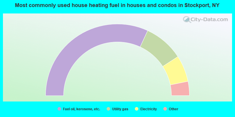
- 63.8%Fuel oil, kerosene, etc.
- 17.9%Utility gas
- 11.9%Electricity
- 3.9%Wood
- 2.5%Bottled, tank, or LP gas
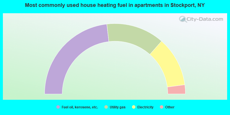
- 46.3%Fuel oil, kerosene, etc.
- 26.7%Utility gas
- 22.8%Electricity
- 2.8%Wood
- 1.4%Bottled, tank, or LP gas
Stockport compared to New York state average:
- Median house value below state average.
- Unemployed percentage significantly below state average.
- Black race population percentage significantly below state average.
- Hispanic race population percentage significantly below state average.
- Foreign-born population percentage significantly below state average.
- Renting percentage below state average.
- Length of stay since moving in significantly above state average.
- Number of rooms per house significantly below state average.
- House age significantly below state average.
- Percentage of population with a bachelor's degree or higher significantly below state average.