Hartford, South Dakota
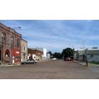
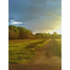
Submit your own pictures of this city and show them to the world
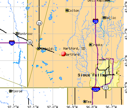
- OSM Map
- General Map
- Google Map
- MSN Map
Population change since 2000: +85.9%
| Males: 1,767 | |
| Females: 1,661 |
| Median resident age: | 39.8 years |
| South Dakota median age: | 38.5 years |
Zip codes: 57033.
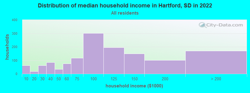
| Hartford: | $95,228 |
| SD: | $69,728 |
Estimated per capita income in 2022: $44,230 (it was $20,726 in 2000)
Hartford city income, earnings, and wages data
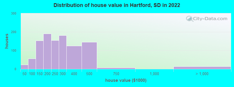
Estimated median house or condo value in 2022: $231,598 (it was $89,100 in 2000)
| Hartford: | $231,598 |
| SD: | $245,000 |
Mean prices in 2022: all housing units: $287,810; detached houses: $301,349; townhouses or other attached units: $239,249; in 2-unit structures: $174,177; in 3-to-4-unit structures: $202,398; in 5-or-more-unit structures: $248,491; mobile homes: $48,605
Median gross rent in 2022: $747.
(3.9% for White Non-Hispanic residents, 4.8% for Hispanic or Latino residents, 100.0% for other race residents)
Detailed information about poverty and poor residents in Hartford, SD
Compare current foreclosures near Hartford, SD:
| Photo | Address | Area | Beds / Baths | Price | Details |
|---|---|---|---|---|---|

|
#1
Ruud Ln Apt 38
Hartford, SD 57033
|
- sq. feet
|
- baths - beds |
show details | |

|
#2
S Jessica Ave
Sioux Falls, SD 57103
|
936 sq. feet
|
1 baths 2 beds |
show details | |

|
#3
W 26th St
Sioux Falls, SD 57105
|
1,357 sq. feet
|
5 baths 3 beds |
show details | |

|
#4
N Dubuque Ave
Sioux Falls, SD 57110
|
1,132 sq. feet
|
1 baths 2 beds |
show details | |

|
#5
S Phillips Ave
Sioux Falls, SD 57105
|
884 sq. feet
|
1 baths 2 beds |
show details | |

|
#6
W 15th St
Sioux Falls, SD 57104
|
1,344 sq. feet
|
3 baths 3 beds |
show details | |

|
#7
N Euclid Ave
Sioux Falls, SD 57104
|
1,118 sq. feet
|
2 baths 3 beds |
show details | |

|
#8
W Panda Dr
Sioux Falls, SD 57107
|
1,260 sq. feet
|
2 baths 2 beds |
show details | |

|
#9
W 56th St
Sioux Falls, SD 57106
|
1,710 sq. feet
|
3 baths 3 beds |
show details | |

|
#10
N Lowell Ave
Sioux Falls, SD 57103
|
1,780 sq. feet
|
3 baths 3 beds |
show details |
| Photo | Address | Area | Beds / Baths | Price | Details |
|---|---|---|---|---|---|

|
#11
S Western Ave
Sioux Falls, SD 57104
|
2,192 sq. feet
|
3 baths 3 beds |
show details | |

|
#12
S Cathy Ave
Sioux Falls, SD 57106
|
1,724 sq. feet
|
4 baths 3 beds |
show details | |

|
#13
E 5th St
Colton, SD 57018
|
1,796 sq. feet
|
3 baths 2 beds |
show details | |

|
#14
W 53rd St
Sioux Falls, SD 57106
|
1,808 sq. feet
|
3 baths 3 beds |
show details | |

|
#15
474th Ave
Baltic, SD 57003
|
1,702 sq. feet
|
2 baths 4 beds |
show details | |

|
#16
S Bahnson Ave # 2
Sioux Falls, SD 57103
|
1,850 sq. feet
|
3 baths 4 beds |
show details | |

|
#17
S Arden Ave
Sioux Falls, SD 57103
|
2,182 sq. feet
|
4 baths 3 beds |
show details | |

|
#18
W 52nd St
Sioux Falls, SD 57106
|
1,994 sq. feet
|
3 baths 2 beds |
show details | |

|
#19
S Main Ave
Sioux Falls, SD 57105
|
2,068 sq. feet
|
2 baths 2 beds |
show details | |

|
#20
S 4th Ave
Sioux Falls, SD 57105
|
2,187 sq. feet
|
3 baths 3 beds |
show details |
| Photo | Address | Area | Beds / Baths | Price | Details |
|---|---|---|---|---|---|

|
#21
S Terry Ave
Sioux Falls, SD 57106
|
1,496 sq. feet
|
3 baths 3 beds |
show details | |

|
#22
S Locust Dr
Sioux Falls, SD 57105
|
1,837 sq. feet
|
4 baths 4 beds |
show details | |

|
#23
S Willow Ave
Sioux Falls, SD 57104
|
1,369 sq. feet
|
3 baths 3 beds |
show details | |

|
#24
E 24th St
Sioux Falls, SD 57103
|
1,372 sq. feet
|
3 baths 3 beds |
show details | |

|
#25
N Blauvelt Ave
Sioux Falls, SD 57103
|
1,721 sq. feet
|
3 baths 2 beds |
show details | |

|
#26
E 12th St
Sioux Falls, SD 57103
|
1,784 sq. feet
|
4 baths 3 beds |
show details | |

|
#27
S Summit Ave
Sioux Falls, SD 57104
|
1,364 sq. feet
|
4 baths 4 beds |
show details | |

|
#28
S Summit Ave
Sioux Falls, SD 57104
|
1,853 sq. feet
|
4 baths 4 beds |
show details | |

|
#29
S Blauvelt Ave
Sioux Falls, SD 57105
|
1,311 sq. feet
|
3 baths 2 beds |
show details | |

|
#30
S Bruce Rd
Sioux Falls, SD 57105
|
1,482 sq. feet
|
3 baths 3 beds |
show details |
| Photo | Address | Area | Beds / Baths | Price | Details |
|---|---|---|---|---|---|

|
#31
N Alaska Ave
Sioux Falls, SD 57107
|
1,496 sq. feet
|
3 baths 3 beds |
show details | |

|
#32
S Harrington Ave
Sioux Falls, SD 57103
|
1,709 sq. feet
|
3 baths 3 beds |
show details | |

|
#33
E 19th St
Sioux Falls, SD 57103
|
1,808 sq. feet
|
3 baths 3 beds |
show details | |

|
#34
E Ronning Dr
Sioux Falls, SD 57103
|
1,560 sq. feet
|
3 baths 3 beds |
show details | |

|
#35
S Glendale Ave
Sioux Falls, SD 57104
|
1,008 sq. feet
|
3 baths 3 beds |
show details | |

|
#36
S Point Dr
Sioux Falls, SD 57103
|
1,596 sq. feet
|
3 baths 3 beds |
show details | |

|
#37
S Kennedy Ave
Sioux Falls, SD 57103
|
1,596 sq. feet
|
3 baths 3 beds |
show details | |

|
#38
E 3rd St Apt 6
Sioux Falls, SD 57110
|
1,060 sq. feet
|
2 baths 2 beds |
show details | |

|
#39
N Main Ave
Sioux Falls, SD 57104
|
680 sq. feet
|
2 baths 2 beds |
show details | |

|
#40
N Duluth Ave
Sioux Falls, SD 57104
|
1,149 sq. feet
|
2 baths 3 beds |
show details |
| Photo | Address | Area | Beds / Baths | Price | Details |
|---|---|---|---|---|---|

|
#41
S Comet Rd
Sioux Falls, SD 57103
|
1,641 sq. feet
|
4 baths 3 beds |
show details | |

|
#42
S Madison St
Humboldt, SD 57035
|
986 sq. feet
|
2 baths 3 beds |
show details | |

|
#43
E Stone Pointe Cir
Sioux Falls, SD 57108
|
18,847 sq. feet
|
3 baths 3 beds |
show details | |

|
#44
S Foster Ave
Sioux Falls, SD 57103
|
1,240 sq. feet
|
2 baths 3 beds |
show details | |

|
#45
W Mesa Pass
Sioux Falls, SD 57106
|
1,228 sq. feet
|
2 baths 3 beds |
show details | |

|
#46
N Teal Pl
Sioux Falls, SD 57107
|
1,568 sq. feet
|
3 baths 3 beds |
show details | |

|
#47
W Chickadee Pl
Sioux Falls, SD 57107
|
1,216 sq. feet
|
3 baths 3 beds |
show details | |

|
#48
N Pelican Pl
Sioux Falls, SD 57107
|
1,064 sq. feet
|
3 baths 3 beds |
show details | |

|
#49
W 10th St # 7
Sioux Falls, SD 57107
|
1,448 sq. feet
|
3 baths 2 beds |
show details | |

|
Check over 1 million property listings on Foreclosure.com!
|
browse all offers | |||


- 2,98886.7%White alone
- 3159.1%Two or more races
- 932.7%Hispanic
- 300.9%American Indian alone
- 180.5%Black alone
- 50.1%Asian alone
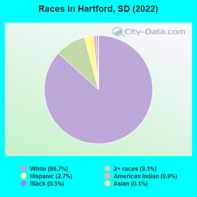
Races in Hartford detailed stats: ancestries, foreign born residents, place of birth
According to our research of South Dakota and other state lists, there were 6 registered sex offenders living in Hartford, South Dakota as of May 06, 2024.
The ratio of all residents to sex offenders in Hartford is 505 to 1.
The ratio of registered sex offenders to all residents in this city is lower than the state average.
 Recent articles from our blog. Our writers, many of them Ph.D. graduates or candidates, create easy-to-read articles on a wide variety of topics.

 | Questions about the area surrounding the USPS office at 4801 N 4th (4 replies) |
| City/Town Recommendations (4 replies) |
| Small town around Sioux Falls? Recommendations? (18 replies) |
| SE Sioux Falls or Brandon? (5 replies) |
| Homes for Rent in Hartford, SD (0 replies) |
| where to eat in Sioux Falls (34 replies) |
Latest news from Hartford, SD collected exclusively by city-data.com from local newspapers, TV, and radio stations
Ancestries: American (30.2%), German (20.5%), English (8.3%), Norwegian (6.4%), European (3.6%), Polish (3.1%).
Current Local Time: CST time zone
Elevation: 1568 feet
Land area: 1.49 square miles.
Population density: 2,299 people per square mile (low).
74 residents are foreign born (1.8% Europe).
| This city: | 2.1% |
| South Dakota: | 3.8% |
Median real estate property taxes paid for housing units with mortgages in 2022: $3,453 (1.3%)
Median real estate property taxes paid for housing units with no mortgage in 2022: $2,863 (1.8%)
Nearest city with pop. 50,000+: Sioux Falls, SD  (12.3 miles , pop. 123,975).
Nearest city with pop. 200,000+: Omaha, NE (170.3 miles , pop. 390,007).
Nearest city with pop. 1,000,000+: Chicago, IL (486.4 miles , pop. 2,896,016).
Nearest cities:
), ), ), ), ), )Latitude: 43.62 N, Longitude: 96.95 W
Area code: 605

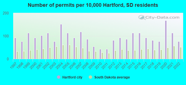
Single-family new house construction building permits:
- 2022: 14 buildings, average cost: $251,700
- 2021: 21 buildings, average cost: $227,000
- 2020: 31 buildings, average cost: $250,900
- 2019: 14 buildings, average cost: $231,900
- 2018: 15 buildings, average cost: $156,900
- 2017: 17 buildings, average cost: $146,400
- 2016: 21 buildings, average cost: $157,200
- 2015: 21 buildings, average cost: $157,300
- 2014: 16 buildings, average cost: $155,100
- 2013: 17 buildings, average cost: $169,900
- 2012: 15 buildings, average cost: $146,600
- 2011: 8 buildings, average cost: $134,300
- 2010: 8 buildings, average cost: $134,300
- 2009: 10 buildings, average cost: $105,000
- 2008: 16 buildings, average cost: $64,700
- 2007: 22 buildings, average cost: $88,700
- 2006: 17 buildings, average cost: $89,000
- 2005: 21 buildings, average cost: $87,500
- 2004: 28 buildings, average cost: $80,100
- 2003: 14 buildings, average cost: $87,100
- 2002: 21 buildings, average cost: $90,800
- 2001: 19 buildings, average cost: $93,500
- 2000: 17 buildings, average cost: $92,500
- 1999: 21 buildings, average cost: $91,600
- 1998: 14 buildings, average cost: $80,400
- 1997: 17 buildings, average cost: $79,000
| Here: | 1.9% |
| South Dakota: | 2.0% |
- Finance & insurance (14.7%)
- Health care (10.3%)
- Construction (7.4%)
- Educational services (6.8%)
- Accommodation & food services (5.3%)
- Truck transportation (4.0%)
- Repair & maintenance (3.0%)
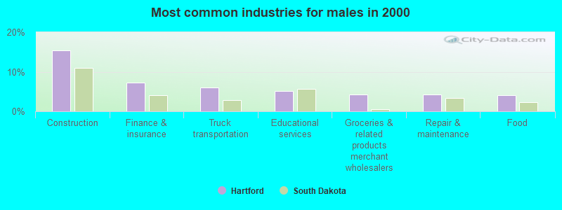
- Construction (15.4%)
- Finance & insurance (7.2%)
- Truck transportation (6.0%)
- Educational services (5.1%)
- Groceries & related products merchant wholesalers (4.3%)
- Repair & maintenance (4.3%)
- Food (4.1%)
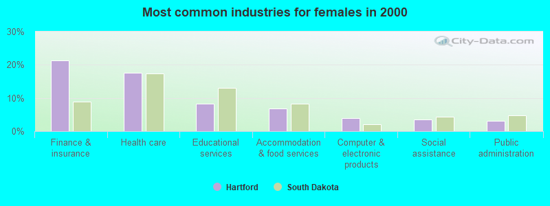
- Finance & insurance (21.3%)
- Health care (17.7%)
- Educational services (8.2%)
- Accommodation & food services (6.9%)
- Computer & electronic products (3.8%)
- Social assistance (3.5%)
- Public administration (3.1%)
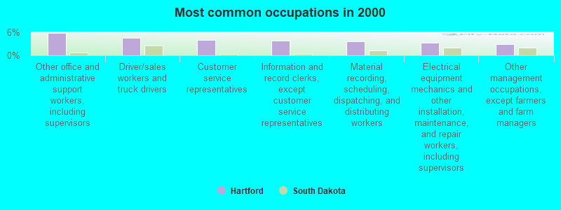
- Other office and administrative support workers, including supervisors (5.9%)
- Driver/sales workers and truck drivers (4.6%)
- Customer service representatives (4.1%)
- Information and record clerks, except customer service representatives (3.8%)
- Material recording, scheduling, dispatching, and distributing workers (3.6%)
- Electrical equipment mechanics and other installation, maintenance, and repair workers, including supervisors (3.3%)
- Other management occupations, except farmers and farm managers (2.9%)
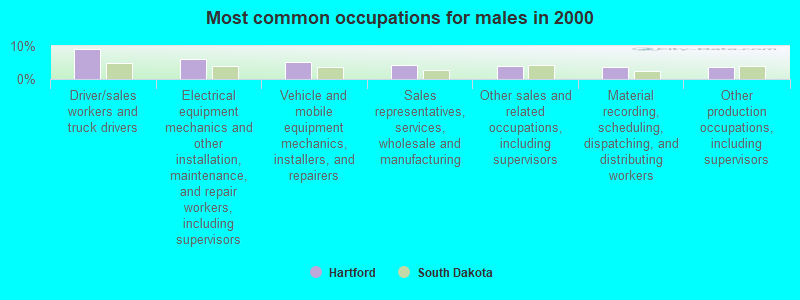
- Driver/sales workers and truck drivers (9.2%)
- Electrical equipment mechanics and other installation, maintenance, and repair workers, including supervisors (6.0%)
- Vehicle and mobile equipment mechanics, installers, and repairers (5.1%)
- Sales representatives, services, wholesale and manufacturing (4.3%)
- Other sales and related occupations, including supervisors (3.9%)
- Material recording, scheduling, dispatching, and distributing workers (3.7%)
- Other production occupations, including supervisors (3.7%)
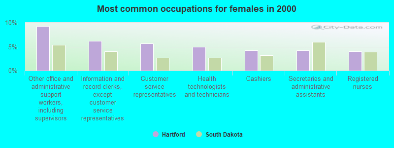
- Other office and administrative support workers, including supervisors (9.3%)
- Information and record clerks, except customer service representatives (6.2%)
- Customer service representatives (5.6%)
- Health technologists and technicians (4.9%)
- Cashiers (4.2%)
- Secretaries and administrative assistants (4.2%)
- Registered nurses (4.0%)
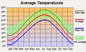
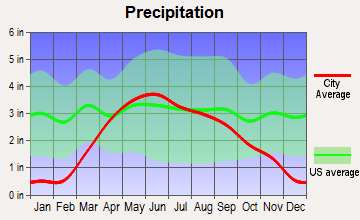
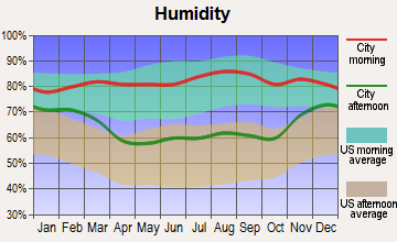
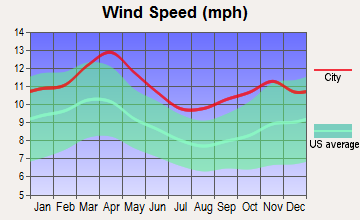
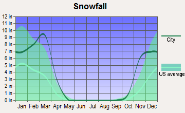
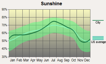
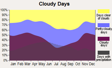
Average climate in Hartford, South Dakota
Based on data reported by over 4,000 weather stations
|
|


(lower is better)
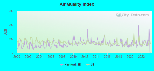
Air Quality Index (AQI) level in 2022 was 69.5. This is about average.
| City: | 69.5 |
| U.S.: | 72.6 |
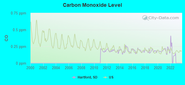
Carbon Monoxide (CO) [ppm] level in 2022 was 0.195. This is better than average. Closest monitor was 8.3 miles away from the city center.
| City: | 0.195 |
| U.S.: | 0.251 |
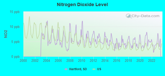
Nitrogen Dioxide (NO2) [ppb] level in 2022 was 3.69. This is better than average. Closest monitor was 8.3 miles away from the city center.
| City: | 3.69 |
| U.S.: | 5.11 |
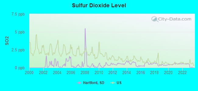
Sulfur Dioxide (SO2) [ppb] level in 2022 was 0.525. This is significantly better than average. Closest monitor was 8.3 miles away from the city center.
| City: | 0.525 |
| U.S.: | 1.515 |
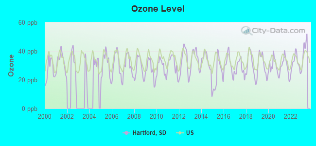
Ozone [ppb] level in 2022 was 31.5. This is about average. Closest monitor was 8.3 miles away from the city center.
| City: | 31.5 |
| U.S.: | 33.3 |
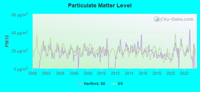
Particulate Matter (PM10) [µg/m3] level in 2022 was 20.6. This is about average. Closest monitor was 8.3 miles away from the city center.
| City: | 20.6 |
| U.S.: | 19.2 |
Particulate Matter (PM2.5) [µg/m3] level in 2022 was 5.03. This is significantly better than average. Closest monitor was 8.3 miles away from the city center.
| City: | 5.03 |
| U.S.: | 8.11 |
Tornado activity:
Hartford-area historical tornado activity is above South Dakota state average. It is 90% greater than the overall U.S. average.
On 6/7/1993, a category F4 (max. wind speeds 207-260 mph) tornado 6.7 miles away from the Hartford city center injured 5 people and caused between $5,000,000 and $50,000,000 in damages.
On 6/7/1993, a category F4 tornado 24.3 miles away from the city center injured 4 people and caused between $500,000 and $5,000,000 in damages.
Earthquake activity:
Hartford-area historical earthquake activity is significantly above South Dakota state average. It is 181% greater than the overall U.S. average.On 3/4/1983 at 06:32:18, a magnitude 4.6 (4.4 MB, 4.6 LG, 4.4 ML, Class: Light, Intensity: IV - V) earthquake occurred 129.3 miles away from the city center
On 7/9/1975 at 14:54:15, a magnitude 4.6 (4.6 MB) earthquake occurred 148.2 miles away from Hartford center
On 11/3/2002 at 20:41:56, a magnitude 4.3 (4.3 MB, Depth: 3.1 mi) earthquake occurred 114.8 miles away from Hartford center
On 8/18/1959 at 06:37:13, a magnitude 7.7 (7.7 UK, Class: Major, Intensity: VIII - XII) earthquake occurred 683.3 miles away from Hartford center, causing $26,000,000 total damage
On 10/25/1990 at 06:25:25, a magnitude 3.9 (3.6 MB, 3.9 LG, Depth: 3.1 mi, Class: Light, Intensity: II - III) earthquake occurred 77.2 miles away from the city center
On 6/5/1993 at 01:24:53, a magnitude 4.1 (4.1 LG, Depth: 6.2 mi) earthquake occurred 145.3 miles away from the city center
Magnitude types: regional Lg-wave magnitude (LG), body-wave magnitude (MB), local magnitude (ML)
Natural disasters:
The number of natural disasters in Minnehaha County (14) is near the US average (15).Major Disasters (Presidential) Declared: 10
Emergencies Declared: 2
Causes of natural disasters: Floods: 8, Storms: 6, Winter Storms: 4, Tornadoes: 3, Snowstorms: 2, Blizzard: 1, Drought: 1, Hurricane: 1, Other: 1 (Note: some incidents may be assigned to more than one category).
Hospitals and medical centers near Hartford:
- SANFORD VISITING NURSES ASSOCIATION (Home Health Center, about 11 miles away; SIOUX FALLS, SD)
- SANFORD HOSPICE (Hospital, about 11 miles away; SIOUX FALLS, SD)
- GOOD SAMARITAN SOCIETY SIOUX FALLS VILLAGE (Nursing Home, about 12 miles away; SIOUX FALLS, SD)
- GOLDEN LIVINGCENTER - COVINGTON HEIGHTS (Nursing Home, about 12 miles away; SIOUX FALLS, SD)
- GOOD SAMARITAN SOCIETY - HOME CARE (Home Health Center, about 12 miles away; SIOUX FALLS, SD)
- SIOUX FALLS VA MEDICAL CENTER (Hospital, Acute Care - Veterans Administration, about 12 miles away; SIOUX FALLS, SD)
- CHARTER SF BEHAVIORAL HEALTH SYSTEM (Hospital, about 12 miles away; SIOUX FALLS, SD)
Airports located in Hartford:
- Oakleaf Airport (9SD8) (Runways: 1)
Colleges/universities with over 2000 students nearest to Hartford:
- Southeast Technical Institute (about 10 miles; Sioux Falls, SD; Full-time enrollment: 2,386)
- South Dakota State University (about 49 miles; Brookings, SD; FT enrollment: 10,392)
- University of South Dakota (about 59 miles; Vermillion, SD; FT enrollment: 7,328)
- Southwest Minnesota State University (about 83 miles; Marshall, MN; FT enrollment: 3,711)
- Western Iowa Tech Community College (about 85 miles; Sioux City, IA; FT enrollment: 3,544)
- Wayne State College (about 96 miles; Wayne, NE; FT enrollment: 3,121)
- Minnesota West Community and Technical College (about 107 miles; Granite Falls, MN; FT enrollment: 2,225)
Public high school in Hartford:
- WEST CENTRAL HIGH SCHOOL - 01 (Students: 351, Location: 705 E 2ND, Grades: 9-12)
Public elementary/middle schools in Hartford:
- WEST CENTRAL MIDDLE SCHOOL - 04 (Students: 283, Location: 705 E 2ND ST, Grades: 6-8)
- WEST CENTRAL HARTFORD ELEMENTARY - 05 (Location: 303 E 2ND ST, Grades: KG-2)
Points of interest:
Notable locations in Hartford: Hartford Fire and Rescue Department (A), Hartford City Hall (B), Hartford-West Central Branch Library (C). Display/hide their locations on the map
Cemetery: Saint George Cemetery (1). Display/hide its location on the map
Tourist attraction: GH Designs (Arcades & Amusements; 300 E. 6th Street).
Drinking water stations with addresses in Hartford that have no violations reported:
- HARTFORD (Population served: 2,634, Primary Water Source Type: Purch groundwater)
| This city: | 2.8 people |
| South Dakota: | 2.4 people |
| This city: | 74.9% |
| Whole state: | 64.2% |
| This city: | 5.3% |
| Whole state: | 6.5% |
Likely homosexual households (counted as self-reported same-sex unmarried-partner households)
- Lesbian couples: 0.2% of all households
- Gay men: 0.0% of all households
Banks with branches in Hartford (2011 data):
- Home Federal Bank: Highway 38 Branch at 202 West Highway 38, branch established on 1996/06/30. Info updated 2011/07/21: Bank assets: $1,224.2 mil, Deposits: $946.5 mil, headquarters in Sioux Falls, SD, positive income, Commercial Lending Specialization, 34 total offices
- U.S. Bank National Association: Hartford Branch at 103 South Main, branch established on 1925/07/15. Info updated 2012/01/30: Bank assets: $330,470.8 mil, Deposits: $236,091.5 mil, headquarters in Cincinnati, OH, positive income, 3121 total offices, Holding Company: U.S. Bancorp
- Reliabank Dakota: Hartford Branch at 304 West Highway 38, Suite 142, branch established on 2007/06/18. Info updated 2011/01/10: Bank assets: $223.0 mil, Deposits: $193.2 mil, headquarters in Estelline, SD, positive income, Agricultural Specialization, 8 total offices, Holding Company: Big Sioux Financial, Inc.
For population 15 years and over in Hartford:
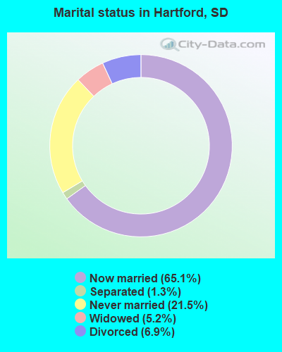
- Never married: 21.5%
- Now married: 65.1%
- Separated: 1.3%
- Widowed: 5.2%
- Divorced: 6.9%
For population 25 years and over in Hartford:
- High school or higher: 97.2%
- Bachelor's degree or higher: 31.8%
- Graduate or professional degree: 5.8%
- Unemployed: 3.2%
- Mean travel time to work (commute): 18.9 minutes
| Here: | 8.0 |
| South Dakota average: | 10.5 |
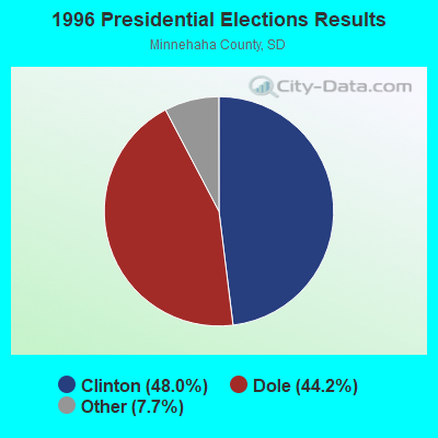
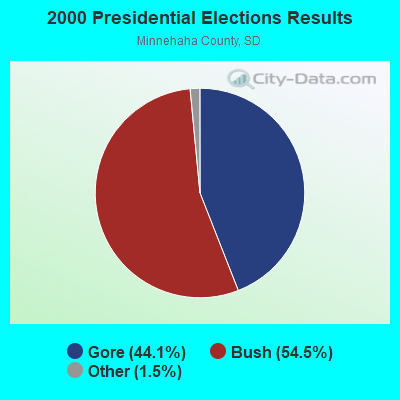
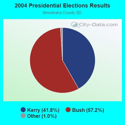
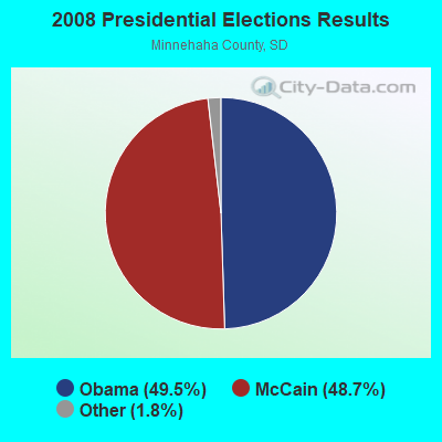
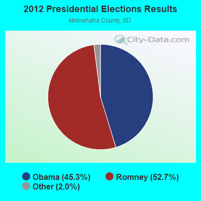
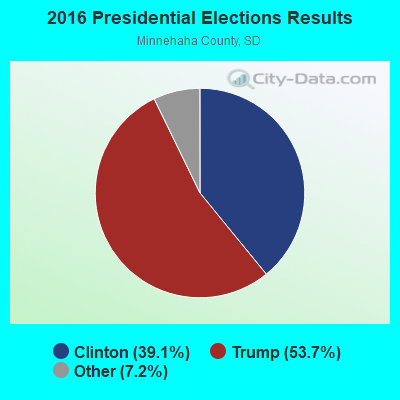
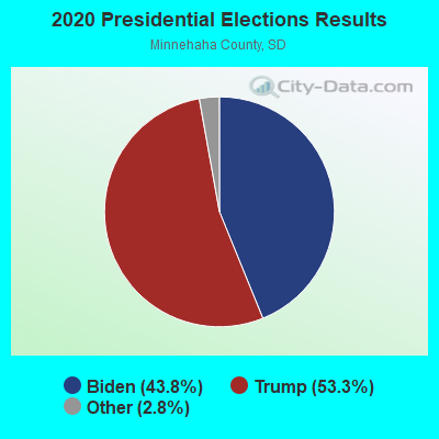
Graphs represent county-level data. Detailed 2008 Election Results
Religion statistics for Hartford, SD (based on Minnehaha County data)
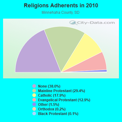
| Religion | Adherents | Congregations |
|---|---|---|
| Mainline Protestant | 49,759 | 80 |
| Catholic | 30,335 | 16 |
| Evangelical Protestant | 21,832 | 84 |
| Other | 2,606 | 12 |
| Orthodox | 260 | 2 |
| Black Protestant | 249 | 1 |
| None | 64,427 | - |
Food Environment Statistics:
| This county: | 1.31 / 10,000 pop. |
| South Dakota: | 2.84 / 10,000 pop. |
| Minnehaha County: | 0.17 / 10,000 pop. |
| South Dakota: | 0.29 / 10,000 pop. |
| This county: | 0.51 / 10,000 pop. |
| State: | 0.65 / 10,000 pop. |
| Minnehaha County: | 4.62 / 10,000 pop. |
| State: | 6.68 / 10,000 pop. |
| This county: | 6.28 / 10,000 pop. |
| South Dakota: | 9.21 / 10,000 pop. |
| This county: | 7.0% |
| South Dakota: | 7.7% |
| Minnehaha County: | 26.7% |
| South Dakota: | 27.7% |
| Minnehaha County: | 15.6% |
| State: | 14.9% |
Health and Nutrition:
| Here: | 57.7% |
| South Dakota: | 51.4% |
| Hartford: | 60.4% |
| State: | 49.4% |
| This city: | 27.8 |
| South Dakota: | 28.5 |
| Hartford: | 17.6% |
| State: | 20.6% |
| Hartford: | 6.0% |
| South Dakota: | 9.7% |
| Hartford: | 7.0 |
| State: | 6.9 |
| Hartford: | 33.1% |
| South Dakota: | 34.1% |
| This city: | 65.5% |
| South Dakota: | 58.1% |
| Here: | 83.4% |
| State: | 78.7% |
More about Health and Nutrition of Hartford, SD Residents
| Local government employment and payroll (March 2022) | |||||
| Function | Full-time employees | Monthly full-time payroll | Average yearly full-time wage | Part-time employees | Monthly part-time payroll |
|---|---|---|---|---|---|
| Other and Unallocable | 3 | $14,253 | $57,012 | 2 | $1,171 |
| Parks and Recreation | 1 | $4,110 | $49,320 | 1 | $676 |
| Sewerage | 1 | $5,921 | $71,052 | 0 | $0 |
| Water Supply | 1 | $5,188 | $62,256 | 0 | $0 |
| Financial Administration | 1 | $6,437 | $77,244 | 0 | $0 |
| Other Government Administration | 1 | $4,002 | $48,024 | 0 | $0 |
| Streets and Highways | 1 | $7,090 | $85,080 | 1 | $226 |
| Totals for Government | 9 | $47,001 | $62,668 | 4 | $2,073 |
Hartford government finances - Expenditure in 2018 (per resident):
- Construction - Sewerage: $135,000 ($39.38)
- Current Operations - Regular Highways: $914,000 ($266.63)
Water Utilities: $867,000 ($252.92)
Parks and Recreation: $501,000 ($146.15)
Financial Administration: $400,000 ($116.69)
Sewerage: $386,000 ($112.60)
Central Staff Services: $149,000 ($43.47)
Health - Other: $115,000 ($33.55)
Libraries: $108,000 ($31.51)
Local Fire Protection: $34,000 ($9.92)
Police Protection: $20,000 ($5.83)
Miscellaneous Commercial Activities - Other: $14,000 ($4.08)
Judicial and Legal Services: $14,000 ($4.08)
- General - Interest on Debt: $115,000 ($33.55)
- Intergovernmental to Local - Other - Police Protection: $217,000 ($63.30)
- Other Capital Outlay - Regular Highways: $54,000 ($15.75)
Sewerage: $54,000 ($15.75)
Water Utilities: $54,000 ($15.75)
- Total Salaries and Wages: $1,253,000 ($365.52)
Hartford government finances - Revenue in 2018 (per resident):
- Charges - Sewerage: $921,000 ($268.67)
Miscellaneous Commercial Activities: $129,000 ($37.63)
- Miscellaneous - Special Assessments: $711,000 ($207.41)
Donations From Private Sources: $102,000 ($29.75)
Rents: $61,000 ($17.79)
Sale of Property: $41,000 ($11.96)
Interest Earnings: $41,000 ($11.96)
- Revenue - Water Utilities: $1,097,000 ($320.01)
- State Intergovernmental - Highways: $149,000 ($43.47)
General Local Government Support: $20,000 ($5.83)
Health and Hospitals: $7,000 ($2.04)
- Tax - General Sales and Gross Receipts: $4,273,000 ($1246.50)
Property: $542,000 ($158.11)
Occupation and Business License - Other: $74,000 ($21.59)
Alcoholic Beverage License: $34,000 ($9.92)
Hartford government finances - Debt in 2018 (per resident):
- Long Term Debt - Beginning Outstanding - Unspecified Public Purpose: $3,914,000 ($1141.77)
Outstanding Unspecified Public Purpose: $2,844,000 ($829.64)
Retired Unspecified Public Purpose: $1,070,000 ($312.14)
Hartford government finances - Cash and Securities in 2018 (per resident):
- Other Funds - Cash and Securities: $16,408,000 ($4786.46)
Businesses in Hartford, SD
- FedEx: 1
- Subway: 1
Strongest AM radio stations in Hartford:
- KSOO (1140 AM; 10 kW; SIOUX FALLS, SD; Owner: SOUTHERN MINNESOTA BROADCASTING CO.)
- KNWC (1270 AM; 5 kW; SIOUX FALLS, SD; Owner: NORTHWESTERN COLLEGE)
- KXRB (1000 AM; 10 kW; SIOUX FALLS, SD)
- KELO (1320 AM; 5 kW; SIOUX FALLS, SD; Owner: MIDCONTINENT RADIO OF S.D., INC.)
- KLOH (1050 AM; 9 kW; PIPESTONE, MN; Owner: WALLACE CHRISTENSEN)
- KSQB (1520 AM; daytime; 0 kW; SIOUX FALLS, SD; Owner: L A SKYWAVE, INC.)
- WNAX (570 AM; 5 kW; YANKTON, SD; Owner: SAGA COMMUNICATIONS, INC.)
- KWSN (1230 AM; 1 kW; SIOUX FALLS, SD; Owner: MIDCONTINENT RADIO OF S.D., INC.)
- KFAB (1110 AM; 50 kW; OMAHA, NE; Owner: CAPSTAR TX LIMITED PARTNERSHIP)
- KOIL (1020 AM; 50 kW; PLATTSMOUTH, NE; Owner: WAITT RADIO, INC.)
- WCCO (830 AM; 50 kW; MINNEAPOLIS, MN; Owner: INFINITY MEDIA CORPORATION)
- KKAR (1290 AM; 50 kW; OMAHA, NE; Owner: WAITT RADIO, INC.)
- KFAN (1130 AM; 50 kW; MINNEAPOLIS, MN; Owner: AMFM RADIO LICENSES, L.L.C.)
Strongest FM radio stations in Hartford:
- KKLS-FM (104.7 FM; SIOUX FALLS, SD; Owner: SOUTHERN MINNESOTA BROADCASTING CO.)
- KELO-FM (92.5 FM; SIOUX FALLS, SD; Owner: MIDCONTINENT RADIO OF SOUTH DAKOTA, INC.)
- KTWB (101.9 FM; SIOUX FALLS, SD; Owner: MIDCONTINENT RADIO OF SOUTH DAKOTA, INC.)
- KNWC-FM (96.5 FM; SIOUX FALLS, SD; Owner: NORTHWESTERN COLLEGE)
- KMXC (97.3 FM; SIOUX FALLS, SD; Owner: SOUTHERN MINNESOTA BROADCASTING CO.)
- KRRO (103.7 FM; SIOUX FALLS, SD; Owner: MIDCONTINENT RADIO OF S.D., INC.)
- KIKN-FM (100.5 FM; SALEM, SD; Owner: SOUTHERN MINNESOTA B/CNG. COMPANY)
- KKHG (107.9 FM; FLANDREAU, SD; Owner: LA COMMUNIQUE, INC.)
- KVCF (90.5 FM; FREEMAN, SD; Owner: VCY AMERICA, INC.)
- K252DG (98.3 FM; SIOUX FALLS, SD; Owner: CHRISTIAN HERITAGE BROADCASTING, INC.)
- KSQB-FM (95.7 FM; DELL RAPIDS, SD; Owner: L A RADIO, INC.)
- KYBB (102.7 FM; CANTON, SD; Owner: SOUTHERN MINNESOTA B/C COMPANY)
- KLQL (101.1 FM; LUVERNE, MN; Owner: THREE EAGLES OF LUVERNE, INC.)
- KCFS (94.5 FM; SIOUX FALLS, SD; Owner: UNIVERSITY OF SIOUX FALLS)
- KCSD (90.9 FM; SIOUX FALLS, SD; Owner: UNIVERSITY OF SIOUX FALLS)
- KAUR (89.1 FM; SIOUX FALLS, SD; Owner: AUGUSTANA COLLEGE ASSOCIATION)
- KRSD (88.1 FM; SIOUX FALLS, SD; Owner: MINNESOTA PUBLIC RADIO)
- K261CI (100.1 FM; SIOUX FALLS, SD; Owner: SOUTHERN MINNESOTA B/CNG COMPANY)
TV broadcast stations around Hartford:
- KTTW (Channel 17; SIOUX FALLS, SD; Owner: INDEPENDENT COMMUNICATIONS, INC.)
- KELO-TV (Channel 11; SIOUX FALLS, SD; Owner: YOUNG BROADCASTING OF SIOUX FALLS, INC.)
- KDLT-TV (Channel 46; SIOUX FALLS, SD; Owner: RED RIVER BROADCAST CO., LLC)
- KSFY-TV (Channel 13; SIOUX FALLS, SD; Owner: ELCOM OF SOUTH DAKOTA, INC.)
- K67GH (Channel 67; OTTUMWA, IA; Owner: MS COMMUNICATIONS, LLC)
- KDLV-TV (Channel 5; MITCHELL, SD; Owner: RED RIVER BROADCAST CO., LLC)
- KAUN (Channel 36; SIOUX FALLS, SD; Owner: RAPID BROADCASTING COMPANY)
- K52ES (Channel 52; NORFOLK, NE; Owner: TRINITY BROADCASTING NETWORK)
- K56GF (Channel 56; SIOUX FALLS, SD; Owner: TRINITY BROADCASTING NETWORK)
- K34DR (Channel 34; HUMBOLDT, SD; Owner: INDEPENDENT COMMUNICATIONS, INC.)
- K53EG (Channel 53; SIOUX FALLS, SD; Owner: SIOUXLAND CHRISTIAN BROADCASTING)
- K48DK (Channel 48; SIOUX FALLS, SD; Owner: STUART E. MOEN)
- KCSD-TV (Channel 23; SIOUX FALLS, SD; Owner: SOUTH DAKOTA BOARD OF DIRECTORS FOR ED. TELECOMMUNICATIONS)
- KXWB-LP (Channel 42; SIOUX FALLS, SD; Owner: RAPID BROADCASTING COMPANY)
- KCPO-LP (Channel 26; SIOUX FALLS, SD; Owner: G.I.G., INC.)
- K43GX (Channel 43; MADISON, SD; Owner: TRINITY BROADCASTING NETWORK)
- KBNW-LP (Channel 44; SIOUX FALLS, SD; Owner: RAPID BROADCASTING COMPANY)
Hartford fatal accident list:
Aug 18, 2004 03:35 AM, I-90, Lat: 43.608861, Lon: -96.957576, Vehicles: 2, Persons: 4, Fatalities: 1
Dec 14, 1999 04:50 PM, I-90, Lat: 43.608861, Lon: -96.957576, Vehicles: 2, Persons: 2, Fatalities: 1
- National Bridge Inventory (NBI) Statistics
- 29Number of bridges
- 305ft / 93.2mTotal length
- $11,881,000Total costs
- 89,614Total average daily traffic
- 12,568Total average daily truck traffic
- New bridges - historical statistics
- 11930-1939
- 21940-1949
- 21950-1959
- 71960-1969
- 21970-1979
- 81980-1989
- 11990-1999
- 42000-2009
- 22010-2019
FCC Registered Cell Phone Towers:
2 (See the full list of FCC Registered Cell Phone Towers in Hartford)FCC Registered Antenna Towers:
34 (See the full list of FCC Registered Antenna Towers)FCC Registered Broadcast Land Mobile Towers:
5- Water Twr 4 Ne1/4 Sec 8 Twp 101 N Rge 51 W Fifth Prncpl Mrdn 3 Mi S 1 1/2 Mi W (Lat: 43.571917 Lon: -96.975611), Call Sign: WCH524,
Assigned Frequencies: 173.396 MHz, Grant Date: 02/28/2022, Expiration Date: 01/23/2032, Registrant: Minnehaha Community Water Corp., 47381 248th St, Dell Rapids, SD 57022-5305, Phone: (605) 428-3374, Fax: (605) 428-3395, Email:
- Lat: 43.713639 Lon: -96.931250, Call Sign: WQVD909,
Assigned Frequencies: 451.987 MHz, 452.675 MHz, Grant Date: 01/13/2015, Expiration Date: 01/13/2025, Certifier: Mike Landenfield, Registrant: Sioux Falls Two Way Radio Svc. Inc., 700 E 3rd St, Sioux Falls, SD 57103, Phone: (605) 334-9816, Fax: (605) 334-1554, Email:
- 2010 N Western Ave (Lat: 43.644444 Lon: -96.948333), Call Sign: WRBY918,
Assigned Frequencies: 462.162 MHz, Grant Date: 07/27/2018, Expiration Date: 07/27/2028, Certifier: Byron Shumaker, Registrant: Vantek Communications, 221 S Jessica Ave, Sioux Falls, SD 57103, Phone: (605) 996-1200, Fax: (605) 996-6206, Email:
- 46661 258th St (Lat: 43.641667 Lon: -96.876500), Call Sign: WRHT212,
Assigned Frequencies: 464.062 MHz, 469.062 MHz, Grant Date: 06/11/2020, Expiration Date: 06/11/2030, Certifier: Tyler Klein, Registrant: Two Way Solutions Inc, 700 E 3rd St, Sioux Falls, SD 57103, Phone: (605) 334-9816, Fax: (605) 334-1554, Email:
- 46578 254th St (Lat: 43.705000 Lon: -96.896944), Call Sign: WRVE719,
Assigned Frequencies: 464.437 MHz, 461.462 MHz, 464.100 MHz, 461.300 MHz, Grant Date: 11/10/2022, Expiration Date: 11/10/2032, Certifier: Paul Heiberger, Registrant: Twoway Solutions Inc, 700 E 3rd St, Sioux Falls, SD 57103, Phone: (605) 334-9816, Email:
FCC Registered Microwave Towers:
13 (See the full list of FCC Registered Microwave Towers in this town)FCC Registered Paging Towers:
1 (See the full list of FCC Registered Paging Towers)FCC Registered Amateur Radio Licenses:
10 (See the full list of FCC Registered Amateur Radio Licenses in Hartford)FAA Registered Aircraft:
10 (See the full list of FAA Registered Aircraft in Hartford)| Home Mortgage Disclosure Act Aggregated Statistics For Year 2009 (Based on 1 partial tract) | ||
| C) Refinancings | ||
|---|---|---|
| Number | Average Value | |
| LOANS ORIGINATED | 2 | $183,805 |
| APPLICATIONS APPROVED, NOT ACCEPTED | 0 | $0 |
| APPLICATIONS DENIED | 1 | $98,160 |
| APPLICATIONS WITHDRAWN | 0 | $0 |
| FILES CLOSED FOR INCOMPLETENESS | 0 | $0 |
Detailed HMDA statistics for the following Tracts: 0103.00
2002 - 2018 National Fire Incident Reporting System (NFIRS) incidents
- Fire incident types reported to NFIRS in Hartford, SD
- 18548.3%Outside Fires
- 10527.4%Structure Fires
- 6617.2%Mobile Property/Vehicle Fires
- 277.0%Other
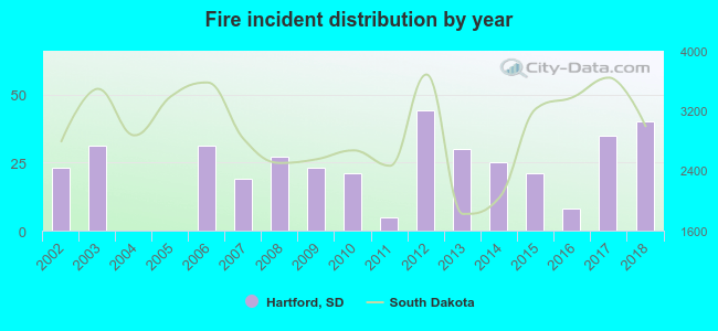 According to the data from the years 2002 - 2018 the average number of fires per year is 23. The highest number of reported fire incidents - 44 took place in 2012, and the least - 0 in 2004. The data has an increasing trend.
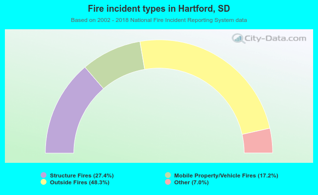 When looking into fire subcategories, the most incidents belonged to: Outside Fires (48.3%), and Structure Fires (27.4%).
| Most common first names in Hartford, SD among deceased individuals | ||
| Name | Count | Lived (average) |
|---|---|---|
| John | 16 | 84.3 years |
| Mary | 16 | 81.4 years |
| Henry | 14 | 80.4 years |
| George | 12 | 77.0 years |
| Robert | 12 | 70.9 years |
| Donald | 11 | 73.3 years |
| Charles | 10 | 72.6 years |
| William | 9 | 76.1 years |
| Carl | 8 | 79.6 years |
| James | 8 | 67.0 years |
| Most common last names in Hartford, SD among deceased individuals | ||
| Last name | Count | Lived (average) |
|---|---|---|
| Johnson | 12 | 83.1 years |
| Anderson | 11 | 81.0 years |
| Muchow | 8 | 82.5 years |
| Mielke | 7 | 82.8 years |
| Boy | 7 | 84.3 years |
| White | 6 | 73.3 years |
| Lueth | 6 | 74.0 years |
| Kelley | 6 | 78.8 years |
| Miller | 6 | 76.3 years |
| Matthies | 5 | 73.6 years |
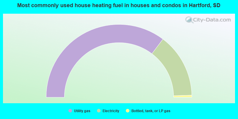
- 70.7%Utility gas
- 28.5%Electricity
- 0.9%Bottled, tank, or LP gas
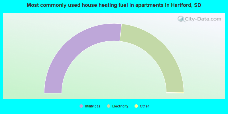
- 53.7%Utility gas
- 46.3%Electricity
Hartford compared to South Dakota state average:
- Unemployed percentage significantly below state average.
- Black race population percentage below state average.
- Median age above state average.
- Length of stay since moving in significantly above state average.
- Percentage of population with a bachelor's degree or higher above state average.

|
Total of 30 patent applications in 2008-2024.