Property valuation of Hampstead Road, La Canada Flintridge, CA: 4190, 4209, 4210, 4219, 4220, 4221, 4250, 4250, 4251, 4269 (tax assessments)
Other nearby streets: Beresford Way  Chevy Chase Drive
Hampstead Road (1)
Hampstead Road (2)
Mesa Vista Drive
Chevy Chase Drive
Hampstead Road (1)
Hampstead Road (2)
Mesa Vista Drive
Chevy Chase Drive
Hampstead Road (1)
Hampstead Road (2)
Mesa Vista Drive
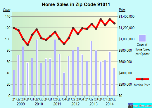
Listed properties vs overall distribution of properties in La Canada Flintridge, CA:
Advertisements
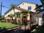
4190 Hampstead Road
La Canada Flintridge, CA 91011
Find on map >>
Total land value: $715,000 (it was $849,600 in 2009)
Total building value: $279,000 (it was $331,400 in 2009)
Total value for property: $994,000 (it was $1,181,000 in 2009)
Recording date: 07/31/2008
Year built: 1957
Effective year built: 1962
Area of property: 2,253 square feet
Assessment for fiscal year: 2012/2013
4209 Hampstead Road
La Canada Flintridge, CA 91011
Find on map >>
Total land value: $84,755 (it was $81,050 in 2009)
Total building value: $163,876 (it was $156,708 in 2009)
Total value for property: $248,631 (it was $237,758 in 2009)
Recording date: 01/30/2008
Year built: 1951
Effective year built: 1959
Area of property: 3,004 square feet
Assessment for fiscal year: 2012/2013
4210 Hampstead Road
La Canada Flintridge, CA 91011
Find on map >>
Total land value: $783,000 (it was $601,821 in 2009)
Total building value: $457,000 (it was $240,569 in 2009)
Total value for property: $1,240,000 (it was $842,390 in 2009)
Recording date: 08/22/2008
Year built: 1980
Effective year built: 1980
Area of property: 2,794 square feet
Assessment for fiscal year: 2012/2013
4219 Hampstead Road
La Canada Flintridge, CA 91011
Find on map >>
Total land value: $1,648,900 (it was $2,136,916 in 2009)
Total building value: $566,100 (it was $112,468 in 2009)
Total value for property: $2,215,000 (it was $2,249,384 in 2009)
Recording date: 11/19/2012
Year built: 1976
Effective year built: 1976
Area of property: 3,793 square feet
Assessment for fiscal year: 2012/2013
4220 Hampstead Road
La Canada Flintridge, CA 91011
Find on map >>
Total land value: $940,915 (it was $899,753 in 2009)
Total building value: $425,775 (it was $407,150 in 2009)
Total value for property: $1,366,690 (it was $1,306,903 in 2009)
Recording date: 08/24/2005
Year built: 1936
Effective year built: 1990
Area of property: 4,310 square feet
Assessment for fiscal year: 2012/2013
4221 Hampstead Road
La Canada Flintridge, CA 91011
Find on map >>
Total land value: $944,766 (it was $903,437 in 2009)
Total building value: $2,012,996 (it was $1,924,933 in 2009)
Total value for property: $2,957,762 (it was $2,828,370 in 2009)
Recording date: 06/02/1999
Year built: 1991
Effective year built: 1991
Area of property: 9,065 square feet
Assessment for fiscal year: 2012/2013
4251 Hampstead Road
La Canada Flintridge, CA 91011
Find on map >>
Total land value: $552,104 (it was $527,952 in 2009)
Total building value: $207,031 (it was $197,976 in 2009)
Total value for property: $759,135 (it was $725,928 in 2009)
Recording date: 11/06/2012
Year built: 1955
Effective year built: 1955
Area of property: 2,548 square feet
Assessment for fiscal year: 2012/2013
4269 Hampstead Road
La Canada Flintridge, CA 91011
Find on map >>
Total land value: $1,305,595 (it was $998,784 in 2009)
Total building value: $1,285,225 (it was $249,696 in 2009)
Total value for property: $2,590,820 (it was $1,248,480 in 2009)
Recording date: 04/12/2007
Assessment for fiscal year: 2012/2013
La Canada Flintridge, CA 91011
Find on map >>
Total land value: $1,305,595 (it was $998,784 in 2009)
Total building value: $1,285,225 (it was $249,696 in 2009)
Total value for property: $2,590,820 (it was $1,248,480 in 2009)
Recording date: 04/12/2007
Assessment for fiscal year: 2012/2013
Other nearby streets: Beresford Way
Chevy Chase Drive
Hampstead Road (1)
Hampstead Road (2)
Mesa Vista Drive
Chevy Chase Drive
Hampstead Road (1)
Hampstead Road (2)
Mesa Vista Drive

Recent posts about La Canada Flintridge, California on our local forum with over 2,400,000 registered users. La Canada Flintridge is mentioned 403 times on our forum:
 | Possible relocation to Pasadena area from East Coast (NJ)- Any Advice? (61 replies) |
| Danville vs. Lafayette vs. San Ramon (36 replies) |
| Your nicest experiences in La Canada Flintridge. (8 replies) |
| Where's the grass, trees, and suburbs in LA? (71 replies) |
| Best public elementary school within 20-25 miles from downtown LA (4 replies) |
| Why is Arcadia, CA so unfriendly? (121 replies) |
Recently Added Photos
San Francisco, CA
Redwood City, CA
Paradise, CA
Auberry, CA
Paramount, CA

Shaver Lake, CA
Visalia, CA
Biggs, CA
Long Beach, CA

Yucca Valley, CA
Los Angeles, CA
Los Angeles, CA
Request disassociating your name from street-level assessment address

Recent home sales, price trends, and home value evaluator powered by Onboard Informatics
© 2024 Onboard Informatics. Information is deemed reliable but not guaranteed.
© 2024 Onboard Informatics. Information is deemed reliable but not guaranteed.
Some parts © 2024 Advameg, Inc.
Compilation, repackaging, or reproduction prohibited. Users are forewarned that it is incumbent upon them to verify information with the responsible state agency. Advameg, Inc. does not guarantee the data presented is up-to-date nor does it assume responsibility for updating it. Therefore any names, owners or addresses may have changed. Use of any information published here to contact the persons might be prohibited by the law.