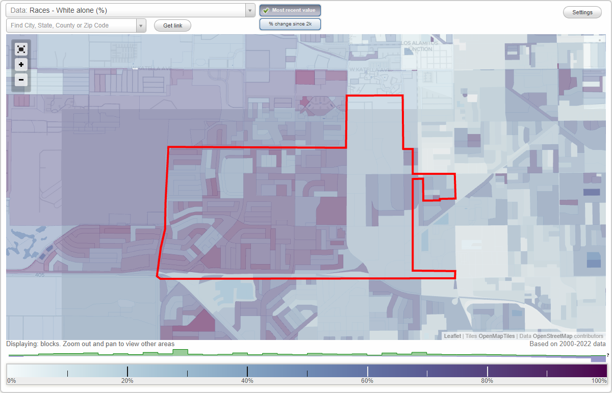
West Garden Grove neighborhood in Garden Grove, California (CA), 92841, 92845 detailed profile
Settings
X

Business Search - 14 Million verified businesses
Area: 3.434 square miles
Population: 19,747
Population density:
| West Garden Grove: | 5,750 people per square mile |
| Garden Grove: | 9,391 people per square mile |

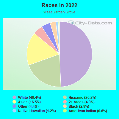
- 10,41649.4%White
- 4,26420.2%Hispanic or Latino
- 3,47516.5%Asian
- 1,0304.9%Two or more races
- 9204.4%Some other race
- 6052.9%Black
- 2451.2%Native Hawaiian and Other
Pacific Islander - 1230.6%American Indian
Median household income in 2022:
| West Garden Grove: | $119,459 |
| Garden Grove: | $86,975 |
Distribution of median household income
![Distribution of median household income]()
- 337Less than $10,000
- 322$10,000 to $19,999
- 334$20,000 to $29,999
- 357$30,000 to $39,999
- 458$40,000 to $49,999
- 397$50,000 to $59,999
- 455$60,000 to $74,999
- 924$75,000 to $99,999
- 724$100,000 to $124,999
- 588$125,000 to $149,999
- 1,235$150,000 to $199,999
- 1,355$200,000 or more

Distribution of owner-occupied house/condo value
![Distribution of owner-occupied house/condo value]()
- 955Less than $50,000
- 1,268$50,000 to $99,999
- 340$100,000 to $149,999
- 412$150,000 to $199,999
- 13$200,000 to $249,999
- 136$250,000 to $299,999
- 132$300,000 to $399,999
- 635$400,000 to $499,999
- 1,142$500,000 to $749,999
- 2,836$750,000 to $999,999
- 791$1,000,000 or more

Distribution of rent paid by renters
![Distribution of rent paid by renters]()
- 99$200 to $299
- 247$300 to $399
- 219$400 to $499
- 188$500 to $599
- 265$600 to $699
- 162$700 to $799
- 100$800 to $899
- 184$900 to $999
- 122$1,000 to $1,249
- 483$1,250 to $1,499
- 673$1,500 to $1,999
- 1,897$2,000 or more

| Males: | 10,299 |
| Females: | 9,448 |
Males:
| This neighborhood: | 39.4 years |
| Whole city: | 38.0 years |
| This neighborhood: | 43.0 years |
| Whole city: | 41.0 years |
Average household size:
| West Garden Grove: | 3.0 people |
| Garden Grove: | 3.4 people |
Percentage of family households:
| West Garden Grove: | 55.0% |
| Garden Grove: | 51.1% |
| Here: | 58.6% |
| Garden Grove: | 51.4% |
Percentage of married-couple families with children (among all households):
| West Garden Grove: | 29.6% |
| Garden Grove: | 20.9% |
Percentage of single-mother households (among all households):
| West Garden Grove: | 4.4% |
| Garden Grove: | 6.8% |
Percentage of never married males 15 years old and over:
Percentage of never married females 15 years old and over:
| West Garden Grove: | 17.3% |
| Garden Grove: | 21.6% |
Percentage of never married females 15 years old and over:
| West Garden Grove: | 11.5% |
| city: | 16.3% |
Percentage of people that speak English not well or not at all:
| West Garden Grove: | 3.9% |
| Garden Grove: | 19.7% |
Percentage of people born in this state:
Percentage of people born in another U.S. state:
Percentage of native residents but born outside the U.S.:
Percentage of foreign born residents:
| Here: | 66.1% |
| Garden Grove: | 48.0% |
Percentage of people born in another U.S. state:
| West Garden Grove: | 15.5% |
| Garden Grove: | 5.9% |
Percentage of native residents but born outside the U.S.:
| Here: | 1.0% |
| city: | 1.5% |
Percentage of foreign born residents:
| Here: | 17.3% |
| Garden Grove: | 44.6% |
Owner-occupied
Renter-occupied

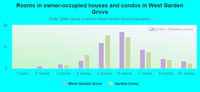
- Rooms in owner-occupied houses and condos in West Garden Grove
- 351 room
- 1082 rooms
- 2013 rooms
- 3644 rooms
- 1,1975 rooms
- 1,7006 rooms
- 8747 rooms
- 4538 rooms
- 3429+ rooms
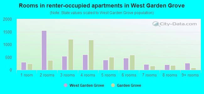
- Rooms in renter-occupied apartments in West Garden Grove
- 3081 room
- 1,5522 rooms
- 5453 rooms
- 6014 rooms
- 3915 rooms
- 4686 rooms
- 2197 rooms
- 2148 rooms
- 2759+ rooms
Owner-occupied
Renter-occupied
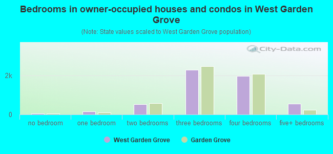
- Bedrooms in owner-occupied houses and condos in West Garden Grove
- 40no bedroom
- 1491 bedroom
- 5182 bedrooms
- 2,2763 bedrooms
- 1,9544 bedrooms
- 5595+ bedrooms
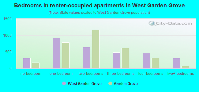
- Bedrooms in renter-occupied apartments in West Garden Grove
- 311no bedroom
- 9251 bedroom
- 6522 bedrooms
- 4803 bedrooms
- 4614 bedrooms
- 3155+ bedrooms
Average number of cars or other vehicles available in houses/condos:
Average number of cars or other vehicles available in apartments:
| This neighborhood: | |
| Garden Grove: |
Average number of cars or other vehicles available in apartments:
| Here: | |
| city: |
Percentage of units with a mortgage:
| West Garden Grove: | 67.7% |
| Garden Grove: | 62.4% |
Average estimated value of detached houses in 2022 (72.6% of all units):
| West Garden Grove: | $833,532 |
| Garden Grove: | $835,074 |
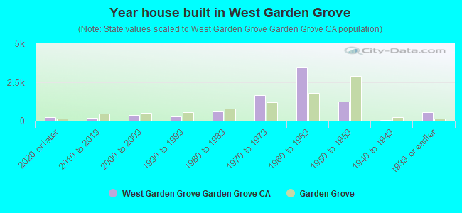
- Year house built in West Garden Grove
- 2072020 or later
- 2032010 to 2019
- 3722000 to 2009
- 2541990 to 1999
- 6071980 to 1989
- 1,6661970 to 1979
- 3,4571960 to 1969
- 1,2471950 to 1959
- 651940 to 1949
- 5351939 or earlier
City-data.com crime index for city in 2020 (higher means more crime):
| City: | 205.1 |
| U.S. average: | 219.5 |
Travel time to work (commute)
![Travel time to work (commute)]()
- 240Less than 5 minutes
- 3995 to 9 minutes
- 87710 to 14 minutes
- 1,15515 to 19 minutes
- 1,32920 to 24 minutes
- 81525 to 29 minutes
- 1,51230 to 34 minutes
- 37235 to 39 minutes
- 44240 to 44 minutes
- 87445 to 59 minutes
- 70260 to 89 minutes
- 29290 or more minutes

Means of transportation to work
![Means of transportation to work]()
- 76.3%7,636Drove a car alone
- 9.0%903Carpooled
- 0.8%76Bus
- 0.6%62Subway or elevated rail
- 0.7%69Long-distance train or commuter rail
- 3.7%375Light rail, streetcar or trolley
- 0.7%68Motorcycle
- 2.3%235Bicycle
- 5.2%523Walked
- 1.1%114Other means
- 11.7%1,172Worked at home

Time leaving home to go to work
![Time leaving home to go to work]()
- 54212:00 a.m. to 4:59 a.m.
- 3845:00 a.m. to 5:29 a.m.
- 4275:30 a.m. to 5:59 a.m.
- 7826:00 a.m. to 6:29 a.m.
- 1,0706:30 a.m. to 6:59 a.m.
- 1,3507:00 a.m. to 7:29 a.m.
- 8777:30 a.m. to 7:59 a.m.
- 7308:00 a.m. to 8:29 a.m.
- 5348:30 a.m. to 8:59 a.m.
- 5379:00 a.m. to 9:59 a.m.
- 42210:00 a.m. to 10:59 a.m.
- 12711:00 a.m. to 11:59 a.m.
- 62812:00 p.m. to 3:59 p.m.
- 4424:00 p.m. to 11:59 p.m.

Occupations of males:
- Percentage of males in management occupations (except farmers):
Here: 15.5% city: 9.2%
- Percentage of males in business and financial operations occupations:
Here: 5.5% city: 3.5%
- Percentage of males in computer and mathematical occupations:
Here: 6.2% city: 4.6%
- Percentage of males in architecture and engineering occupations:
Here: 5.5% city: 3.9%
- Percentage of males in life, physical, and social science occupations:
Here: 1.1% city: 0.7%
- Percentage of males in education, training, and library occupations:
Here: 3.9% city: 2.1%
- Percentage of males in arts, design, entertainment, sports, and media occupations:
Here: 1.3% city: 1.9%
- Percentage of males in healthcare practitioners and technical occupations:
Here: 2.2% city: 2.1%
- Percentage of males in service occupations:
Here: 14.4% city: 16.3%
- Percentage of males in sales and office occupations:
Here: 19.8% city: 16.3%
- Percentage of males in construction, extraction, and maintenance occupations:
Here: 6.1% city: 9.9%
- Percentage of males in production occupations:
Here: 4.5% city: 13.3%
- Percentage of males in transportation occupations:
Here: 3.7% city: 5.4%
- Percentage of males in material moving occupations:
Here: 4.2% city: 4.4%
Occupations of females:
- Percentage of females in management occupations (except farmers):
Here: 9.9% city: 6.6%
- Percentage of females in business and financial operations occupations:
Here: 8.0% city: 6.4%
- Percentage of females in computer and mathematical occupations:
Here: 1.7% city: 1.7%
- Percentage of females in community and social services occupations:
Here: 1.6% city: 1.4%
- Percentage of females in legal occupations:
Here: 1.5% city: 0.8%
- Percentage of females in education, training, and library occupations:
Here: 12.4% city: 6.3%
- Percentage of females in arts, design, entertainment, sports, and media occupations:
Here: 1.8% city: 2.1%
- Percentage of females in healthcare practitioners and technical occupations:
Here: 8.9% city: 6.5%
- Percentage of females in service occupations:
Here: 16.0% city: 27.0%
- Percentage of females in sales and office occupations:
Here: 30.6% city: 26.7%
- Percentage of females in production occupations:
Here: 3.0% city: 8.6%
- Percentage of females in material moving occupations:
Here: 1.6% city: 2.2%
Percentage of people 16-64 in Armed Forces:
| West Garden Grove: | 0.0% |
| Garden Grove: | 0.0% |
Education in this neighborhood (subdivision or community):
- Percentage of people 3 years and older in K-12 schools:
West Garden Grove: 19.2% Garden Grove: 15.3%
- Percentage of people 3 years and older in undergraduate colleges:
West Garden Grove: 6.9% Garden Grove: 6.5%
- Percentage of people 3 years and older in grad. or professional schools:
West Garden Grove: 2.7% Garden Grove: 1.8%
- Percentage of students K-12 enrolled in private schools:
West Garden Grove: 44.7% Garden Grove: 4.3%
Percentage of population below poverty level:
| West Garden Grove: | 6.7% |
| Garden Grove: | 11.3% |
Percentage of married-couple families with both working:
| West Garden Grove: | 83.7% |
| Garden Grove: | 70.1% |
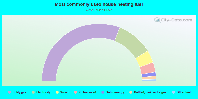
- 61.8%Utility gas
- 20.6%Electricity
- 7.1%Wood
- 5.5%No fuel used
- 2.3%Solar energy
- 1.8%Bottled, tank, or LP gas
- 0.9%Other fuel
Limited-access highways (interstate or state) in this neighborhood:
State Hwy 22 (Garden Grove Fwy)
Length: 2.64 miles
Directions: E-W, SE-NW
Directions: E-W, SE-NW
San Diego Fwy (I- 405)
Length: 0.13 miles
Direction: E-W
Direction: E-W
Highways in this neighborhood:
Roads and streets:
Lampson Ave
Length: 2.74 miles
Directions: E-W, SE-NW
Address range: 5300 to 7499
Directions: E-W, SE-NW
Address range: 5300 to 7499
W Garden Grove Blvd (Garden Grove Blvd)
Length: 2.26 miles
Direction: E-W
Address range: 5800 to 7921
Direction: E-W
Address range: 5800 to 7921
W Chapman Ave
Length: 2.19 miles
Direction: E-W
Address range: 401 to 7499
Direction: E-W
Address range: 401 to 7499
Belgrave Ave
Length: 2.09 miles
Directions: E-W, SE-NW
Address range: 5200 to 7899
Directions: E-W, SE-NW
Address range: 5200 to 7899
Knott St
Length: 1.68 miles
Directions: N-S, SE-NW
Address range: 11400 to 12999
Directions: N-S, SE-NW
Address range: 11400 to 12999
Anthony Ave
Length: 1.65 miles
Directions: E-W, SW-NE
Address range: 5200 to 6999
Directions: E-W, SW-NE
Address range: 5200 to 6999
Santa Catalina Ave
Length: 1.60 miles
Directions: E-W, N-S
Address range: 5000 to 6799
Directions: E-W, N-S
Address range: 5000 to 6799
Cerulean Ave
Length: 1.57 miles
Directions: E-W, SE-NW
Address range: 5200 to 6699
Directions: E-W, SE-NW
Address range: 5200 to 6699
Monarch St
Length: 1.53 miles
Directions: N-S, SE-NW
Address range: 11300 to 12851
Directions: N-S, SE-NW
Address range: 11300 to 12851
Santa Rita Ave
Length: 1.46 miles
Directions: E-W, SW-NE
Address range: 5316 to 6999
Directions: E-W, SW-NE
Address range: 5316 to 6999
Valley View St
Length: 1.46 miles
Directions: N-S, SW-NE
Address range: 11821 to 13049
Directions: N-S, SW-NE
Address range: 11821 to 13049
Vanguard Ave
Length: 1.40 miles
Directions: E-W, SE-NW, SW-NE
Address range: 5300 to 6999
Directions: E-W, SE-NW, SW-NE
Address range: 5300 to 6999
Stanford Ave
Length: 1.40 miles
Directions: E-W, SE-NW, SW-NE
Address range: 5200 to 6999
Directions: E-W, SE-NW, SW-NE
Address range: 5200 to 6999
Trinette Ave
Length: 1.33 miles
Directions: E-W, SE-NW
Address range: 5200 to 6699
Directions: E-W, SE-NW
Address range: 5200 to 6699
Acacia Ave
Length: 1.32 miles
Directions: E-W, SE-NW, SW-NE
Address range: 5200 to 7299
Directions: E-W, SE-NW, SW-NE
Address range: 5200 to 7299
Western Ave
Length: 1.29 miles
Direction: N-S
Address range: 11724 to 12999
Direction: N-S
Address range: 11724 to 12999
Springdale St
Length: 1.23 miles
Directions: N-S, SW-NE
Address range: 11765 to 12999
Directions: N-S, SW-NE
Address range: 11765 to 12999
Santa Barbara Ave
Length: 1.20 miles
Directions: E-W, SW-NE
Address range: 5000 to 6799
Directions: E-W, SW-NE
Address range: 5000 to 6799
Richmond Ave
Length: 1.11 miles
Direction: E-W
Address range: 5200 to 6299
Direction: E-W
Address range: 5200 to 6299
Huntley Ave
Length: 1.05 miles
Direction: E-W
Address range: 5100 to 6299
Direction: E-W
Address range: 5100 to 6299
Saint Mark St (St Mark St)
Length: 0.97 miles
Directions: N-S, SW-NE
Address range: 11700 to 12704
Directions: N-S, SW-NE
Address range: 11700 to 12704
Amy Ave
Length: 0.96 miles
Directions: E-W, SW-NE
Address range: 5300 to 6999
Directions: E-W, SW-NE
Address range: 5300 to 6999
Ludlow Ave
Length: 0.89 miles
Direction: E-W
Address range: 5300 to 6299
Direction: E-W
Address range: 5300 to 6299
Laurelton Ave
Length: 0.88 miles
Direction: E-W
Address range: 5300 to 7899
Direction: E-W
Address range: 5300 to 7899
Park Ave
Length: 0.85 miles
Directions: E-W, SE-NW, SW-NE
Address range: 5200 to 6999
Directions: E-W, SE-NW, SW-NE
Address range: 5200 to 6999
Lamplighter St
Length: 0.82 miles
Directions: N-S, SW-NE
Address range: 11700 to 12706
Directions: N-S, SW-NE
Address range: 11700 to 12706
Bartlett St
Length: 0.75 miles
Directions: E-W, N-S, SW-NE
Address range: 11700 to 12899
Directions: E-W, N-S, SW-NE
Address range: 11700 to 12899
Tunstall St
Length: 0.73 miles
Directions: E-W, N-S, SW-NE
Address range: 11700 to 12799
Directions: E-W, N-S, SW-NE
Address range: 11700 to 12799
Blackmer St
Length: 0.71 miles
Direction: N-S
Address range: 11761 to 12499
Direction: N-S
Address range: 11761 to 12499
Bailey St
Length: 0.71 miles
Directions: E-W, N-S, SE-NW, SW-NE
Address range: 11800 to 12899
Directions: E-W, N-S, SE-NW, SW-NE
Address range: 11800 to 12899
Killarney Ave
Length: 0.69 miles
Direction: E-W
Address range: 5900 to 6799
Direction: E-W
Address range: 5900 to 6799
Orangewood Ave
Length: 0.67 miles
Directions: E-W, SE-NW, SW-NE
Address range: 7000 to 7499
Directions: E-W, SE-NW, SW-NE
Address range: 7000 to 7499
Topaz St
Length: 0.65 miles
Direction: N-S
Address range: 12200 to 12949
Direction: N-S
Address range: 12200 to 12949
Marietta Ave
Length: 0.65 miles
Directions: E-W, SE-NW
Address range: 5200 to 6899
Directions: E-W, SE-NW
Address range: 5200 to 6899
Pickett Ave
Length: 0.64 miles
Direction: E-W
Address range: 6000 to 6699
Direction: E-W
Address range: 6000 to 6699
Industry St
Length: 0.64 miles
Directions: N-S, SW-NE
Address range: 12000 to 12699
Directions: N-S, SW-NE
Address range: 12000 to 12699
Manley St
Length: 0.62 miles
Direction: N-S
Address range: 11800 to 12699
Direction: N-S
Address range: 11800 to 12699
Amethyst St
Length: 0.56 miles
Direction: N-S
Address range: 11700 to 12899
Direction: N-S
Address range: 11700 to 12899
Chase St
Length: 0.56 miles
Directions: N-S, SW-NE
Address range: 12200 to 12899
Directions: N-S, SW-NE
Address range: 12200 to 12899
Winton St
Length: 0.54 miles
Direction: N-S
Address range: 11766 to 12399
Direction: N-S
Address range: 11766 to 12399
George Reyburn Rd
Length: 0.54 miles
Directions: E-W, N-S, SE-NW, SW-NE
Address range: 12550 to 12726
Directions: E-W, N-S, SE-NW, SW-NE
Address range: 12550 to 12726
Lenore Ave
Length: 0.51 miles
Directions: E-W, SW-NE
Address range: 5900 to 6699
Directions: E-W, SW-NE
Address range: 5900 to 6699
Adams St
Length: 0.47 miles
Directions: E-W, N-S, SW-NE
Address range: 12500 to 12899
Directions: E-W, N-S, SW-NE
Address range: 12500 to 12899
Scandia St
Length: 0.47 miles
Direction: N-S
Address range: 11700 to 12703
Direction: N-S
Address range: 11700 to 12703
Markon Dr
Length: 0.46 miles
Direction: N-S
Address range: 11000 to 11799
Direction: N-S
Address range: 11000 to 11799
Emerald St
Length: 0.44 miles
Direction: N-S
Address range: 11700 to 12299
Direction: N-S
Address range: 11700 to 12299
Santa Monica Ave
Length: 0.44 miles
Direction: E-W
Address range: 5300 to 6599
Direction: E-W
Address range: 5300 to 6599
Wild Goose St
Length: 0.44 miles
Direction: N-S
Address range: 11900 to 12899
Direction: N-S
Address range: 11900 to 12899
Casper St
Length: 0.36 miles
Directions: N-S, SE-NW
Address range: 12000 to 12699
Directions: N-S, SE-NW
Address range: 12000 to 12699
Eagle Dr
Length: 0.35 miles
Directions: E-W, N-S, SW-NE
Directions: E-W, N-S, SW-NE
Wutzke St
Length: 0.32 miles
Directions: N-S, SW-NE
Address range: 11700 to 12299
Directions: N-S, SW-NE
Address range: 11700 to 12299
Edison Way
Length: 0.32 miles
Direction: N-S
Address range: 12136 to 12499
Direction: N-S
Address range: 12136 to 12499
Dudman Ave
Length: 0.31 miles
Direction: E-W
Address range: 6000 to 6299
Direction: E-W
Address range: 6000 to 6299
Santa Gertrudes Ave
Length: 0.31 miles
Direction: E-W
Address range: 5268 to 5599
Direction: E-W
Address range: 5268 to 5599
Holland Ave
Length: 0.31 miles
Direction: E-W
Address range: 5225 to 5599
Direction: E-W
Address range: 5225 to 5599
Anaconda Ave
Length: 0.30 miles
Direction: E-W
Address range: 7248 to 7499
Direction: E-W
Address range: 7248 to 7499
Christal Ave
Length: 0.29 miles
Direction: E-W
Address range: 5148 to 5499
Direction: E-W
Address range: 5148 to 5499
Owen St
Length: 0.28 miles
Direction: N-S
Address range: 12300 to 12907
Direction: N-S
Address range: 12300 to 12907
Alonzo Cook St
Length: 0.27 miles
Directions: N-S, SE-NW, SW-NE
Address range: 12650 to 12920
Directions: N-S, SE-NW, SW-NE
Address range: 12650 to 12920
Diamond St
Length: 0.27 miles
Direction: N-S
Address range: 11700 to 12299
Direction: N-S
Address range: 11700 to 12299
Canter St
Length: 0.25 miles
Directions: N-S, SW-NE
Address range: 12000 to 12899
Directions: N-S, SW-NE
Address range: 12000 to 12899
Spring St
Length: 0.25 miles
Direction: N-S
Address range: 12600 to 12899
Direction: N-S
Address range: 12600 to 12899
Poplar St
Length: 0.25 miles
Direction: N-S
Address range: 12400 to 12899
Direction: N-S
Address range: 12400 to 12899
Taylor St
Length: 0.25 miles
Direction: N-S
Address range: 12600 to 12899
Direction: N-S
Address range: 12600 to 12899
Palomar St
Length: 0.24 miles
Direction: N-S
Address range: 12538 to 12899
Direction: N-S
Address range: 12538 to 12899
Hunt Ave
Length: 0.23 miles
Directions: E-W, N-S
Address range: 7300 to 7399
Directions: E-W, N-S
Address range: 7300 to 7399
Doig Dr
Length: 0.23 miles
Directions: E-W, N-S, SW-NE
Address range: 7250 to 7499
Directions: E-W, N-S, SW-NE
Address range: 7250 to 7499
Onyx St
Length: 0.23 miles
Direction: N-S
Address range: 11740 to 11999
Direction: N-S
Address range: 11740 to 11999
Turquoise St
Length: 0.22 miles
Direction: N-S
Address range: 11800 to 12299
Direction: N-S
Address range: 11800 to 12299
Olive St
Length: 0.21 miles
Direction: N-S
Address range: 12700 to 12899
Direction: N-S
Address range: 12700 to 12899
Danvers Dr
Length: 0.20 miles
Direction: E-W
Address range: 6800 to 6899
Direction: E-W
Address range: 6800 to 6899
Sylvan St
Length: 0.20 miles
Direction: N-S
Address range: 12600 to 12904
Direction: N-S
Address range: 12600 to 12904
Longden St
Length: 0.20 miles
Direction: N-S
Address range: 12700 to 12959
Direction: N-S
Address range: 12700 to 12959
Fairchild St
Length: 0.20 miles
Direction: N-S
Address range: 11750 to 12499
Direction: N-S
Address range: 11750 to 12499
Brady Way
Length: 0.19 miles
Directions: E-W, N-S
Address range: 12700 to 12999
Directions: E-W, N-S
Address range: 12700 to 12999
Almondine Dr
Length: 0.19 miles
Direction: E-W
Address range: 6800 to 6999
Direction: E-W
Address range: 6800 to 6999
Lincoln Way
Length: 0.18 miles
Direction: E-W
Address range: 7300 to 7499
Direction: E-W
Address range: 7300 to 7499
Tiffany Ave
Length: 0.17 miles
Direction: SE-NW
Address range: 5500 to 5699
Direction: SE-NW
Address range: 5500 to 5699
Sapphire St
Length: 0.16 miles
Direction: N-S
Address range: 12000 to 12299
Direction: N-S
Address range: 12000 to 12299
Seneca Dr
Length: 0.15 miles
Direction: N-S
Address range: 12800 to 12999
Direction: N-S
Address range: 12800 to 12999
Brightwood Ln
Length: 0.13 miles
Directions: E-W, N-S, SW-NE
Address range: 6900 to 6999
Directions: E-W, N-S, SW-NE
Address range: 6900 to 6999
Dumont St
Length: 0.13 miles
Direction: N-S
Address range: 12700 to 12899
Direction: N-S
Address range: 12700 to 12899
Garnet Cir
Length: 0.13 miles
Direction: N-S
Address range: 11800 to 12299
Direction: N-S
Address range: 11800 to 12299
Topaz Cir
Length: 0.13 miles
Direction: N-S
Address range: 11800 to 12259
Direction: N-S
Address range: 11800 to 12259
Cluster Pines Rd
Length: 0.12 miles
Directions: N-S, SW-NE
Address range: 12500 to 12599
Directions: N-S, SW-NE
Address range: 12500 to 12599
Greenwillow Dr
Length: 0.12 miles
Directions: N-S, SE-NW
Address range: 12500 to 12599
Directions: N-S, SE-NW
Address range: 12500 to 12599
Pala Dr
Length: 0.12 miles
Direction: N-S
Address range: 12600 to 12799
Direction: N-S
Address range: 12600 to 12799
Carlotta St
Length: 0.12 miles
Direction: N-S
Address range: 11700 to 11999
Direction: N-S
Address range: 11700 to 11999
Jasper St
Length: 0.11 miles
Direction: N-S
Address range: 11700 to 12099
Direction: N-S
Address range: 11700 to 12099
Fieldgate St
Length: 0.10 miles
Direction: N-S
Address range: 12000 to 12139
Direction: N-S
Address range: 12000 to 12139
Stonegate Ln
Length: 0.10 miles
Direction: N-S
Address range: 12000 to 12199
Direction: N-S
Address range: 12000 to 12199
Sutter St
Length: 0.10 miles
Direction: N-S
Address range: 12700 to 12808
Direction: N-S
Address range: 12700 to 12808
Garnet St
Length: 0.10 miles
Direction: N-S
Address range: 12500 to 12699
Direction: N-S
Address range: 12500 to 12699
Blades Ave
Length: 0.09 miles
Direction: E-W
Address range: 7170 to 7299
Direction: E-W
Address range: 7170 to 7299
Patterson Dr
Length: 0.09 miles
Direction: E-W
Address range: 7172 to 7249
Direction: E-W
Address range: 7172 to 7249
Fieldstone Ln
Length: 0.09 miles
Directions: N-S, SW-NE
Address range: 12500 to 12699
Directions: N-S, SW-NE
Address range: 12500 to 12699
Knollcrest Ln
Length: 0.08 miles
Directions: E-W, SE-NW
Address range: 6900 to 6999
Directions: E-W, SE-NW
Address range: 6900 to 6999
Bentley Ave (Bently Ave)
Length: 0.08 miles
Direction: E-W
Address range: 7737 to 7899
Direction: E-W
Address range: 7737 to 7899
Santa Rita Cir
Length: 0.08 miles
Direction: E-W
Address range: 7500 to 7599
Direction: E-W
Address range: 7500 to 7599
Mulberry Ln
Length: 0.08 miles
Directions: E-W, SE-NW, SW-NE
Address range: 6800 to 6899
Directions: E-W, SE-NW, SW-NE
Address range: 6800 to 6899
Vanguard Cir
Length: 0.08 miles
Direction: E-W
Address range: 7600 to 7799
Direction: E-W
Address range: 7600 to 7799
Edgemont Ln
Length: 0.07 miles
Directions: N-S, SW-NE
Address range: 12500 to 12699
Directions: N-S, SW-NE
Address range: 12500 to 12699
Honold Cir
Length: 0.07 miles
Direction: E-W
Address range: 7100 to 7171
Direction: E-W
Address range: 7100 to 7171
Weaver Cir
Length: 0.07 miles
Direction: N-S
Address range: 11800 to 11999
Direction: N-S
Address range: 11800 to 11999
Canter Cir
Length: 0.07 miles
Direction: N-S
Address range: 11800 to 11999
Direction: N-S
Address range: 11800 to 11999
Hoover St
Length: 0.06 miles
Direction: N-S
Address range: 12601 to 12999
Direction: N-S
Address range: 12601 to 12999
Carousel Cir
Length: 0.06 miles
Direction: SE-NW
Address range: 5400 to 5551
Direction: SE-NW
Address range: 5400 to 5551
Spencer Johnson Pl
Length: 0.06 miles
Direction: E-W
Address range: 5740 to 5761
Direction: E-W
Address range: 5740 to 5761
Chapman Ave
Length: 0.06 miles
Direction: E-W
Address range: 5500 to 5699
Direction: E-W
Address range: 5500 to 5699
Amethyst Cir
Length: 0.06 miles
Direction: N-S
Address range: 12100 to 12299
Direction: N-S
Address range: 12100 to 12299
Onyx Cir
Length: 0.06 miles
Direction: N-S
Address range: 12100 to 12299
Direction: N-S
Address range: 12100 to 12299
Vera Cir
Length: 0.06 miles
Directions: N-S, SE-NW
Address range: 12200 to 12399
Directions: N-S, SE-NW
Address range: 12200 to 12399
Helene St
Length: 0.05 miles
Direction: SE-NW
Address range: 12600 to 12699
Direction: SE-NW
Address range: 12600 to 12699
Weaver St
Length: 0.05 miles
Direction: N-S
Address range: 12100 to 12299
Direction: N-S
Address range: 12100 to 12299
Converse Howe Cir
Length: 0.05 miles
Direction: E-W
Address range: 5700 to 5799
Direction: E-W
Address range: 5700 to 5799
David Webster Cir
Length: 0.05 miles
Direction: E-W
Address range: 5700 to 5799
Direction: E-W
Address range: 5700 to 5799
Edward Ware Cir
Length: 0.05 miles
Direction: E-W
Address range: 5700 to 5799
Direction: E-W
Address range: 5700 to 5799
Miranda St
Length: 0.05 miles
Direction: N-S
Address range: 11701 to 11851
Direction: N-S
Address range: 11701 to 11851
Vera St
Length: 0.05 miles
Direction: N-S
Address range: 12600 to 12799
Direction: N-S
Address range: 12600 to 12799
Jade St
Length: 0.05 miles
Direction: N-S
Address range: 12000 to 12098
Direction: N-S
Address range: 12000 to 12098
Goldenwest St
Length: 0.04 miles
Direction: N-S
Address range: 12950 to 12999
Direction: N-S
Address range: 12950 to 12999
John Chaffey Cir
Length: 0.04 miles
Directions: E-W, N-S
Address range: 5700 to 5799
Directions: E-W, N-S
Address range: 5700 to 5799
Chatenay Way
Length: 0.04 miles
Direction: N-S
Address range: 12600 to 12699
Direction: N-S
Address range: 12600 to 12699
Romaine Way
Length: 0.04 miles
Direction: N-S
Address range: 12500 to 12699
Direction: N-S
Address range: 12500 to 12699
Healey Ave
Length: 0.04 miles
Directions: SE-NW, SW-NE
Address range: 6600 to 6708
Directions: SE-NW, SW-NE
Address range: 6600 to 6708
Barker St
Length: 0.03 miles
Direction: N-S
Address range: 12400 to 12499
Direction: N-S
Address range: 12400 to 12499
Tunstall Cir
Length: 0.03 miles
Direction: N-S
Address range: 12400 to 12499
Direction: N-S
Address range: 12400 to 12499
Crescent Cir
Length: 0.03 miles
Direction: SE-NW
Address range: 5800 to 5999
Direction: SE-NW
Address range: 5800 to 5999
Taylor Cir
Length: 0.03 miles
Direction: N-S
Address range: 12400 to 12499
Direction: N-S
Address range: 12400 to 12499
Helene Cir
Length: 0.03 miles
Directions: N-S, SE-NW, SW-NE
Address range: 12200 to 12399
Directions: N-S, SE-NW, SW-NE
Address range: 12200 to 12399
Raymond Cir
Length: 0.03 miles
Directions: E-W, SE-NW
Address range: 12500 to 12599
Directions: E-W, SE-NW
Address range: 12500 to 12599
Old Bolsa Chica Rd
Length: 0.02 miles
Directions: N-S, SW-NE
Address range: 13000 to 13009
Directions: N-S, SW-NE
Address range: 13000 to 13009
Railroad features:
Union Pacific RR
Length: 1.82 miles
Directions: E-W, N-S, SE-NW
Directions: E-W, N-S, SE-NW
Other features:
Flood Control Chnnl
Length: 0.48 miles
Direction: E-W
Direction: E-W
Anaheim-Barber City Channel (Flood Control)
Length: 0.08 miles
Directions: E-W, SW-NE
Directions: E-W, SW-NE