Bridge Statistics for Baltimore, Maryland (MD)
Condition, Traffic, Stress, Structural Evaluation, Project Costs
- National Bridge Inventory (NBI) Statistics
- 493Number of bridges
- 20,646ft / 6,293mTotal length
- $782,048,000Total costs
- 14,623,220Total average daily traffic
- 904,848Total average daily truck traffic
- National Bridge Inventory (NBI) Registered Bridges for Baltimore
- No street view available for this location
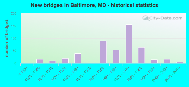
- New bridges - historical statistics
- 2Before 1900
- 161900-1909
- 111910-1919
- 201920-1929
- 391930-1939
- 21940-1949
- 911950-1959
- 541960-1969
- 1561970-1979
- 641980-1989
- 151990-1999
- 162000-2009
- 62010-2019
- 12020-2022
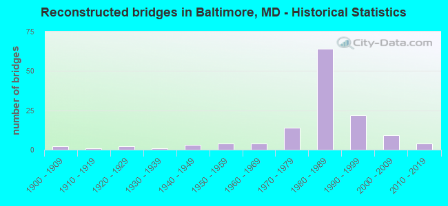
- Reconstructed bridges - Historical Statistics
- 21900-1909
- 11910-1919
- 21920-1929
- 11930-1939
- 31940-1949
- 41950-1959
- 41960-1969
- 141970-1979
- 641980-1989
- 221990-1999
- 92000-2009
- 42010-2019

- Bridge Condition - Deck
- 2.1%Very good
- 48.6%Good
- 34.5%Satisfactory
- 11.1%Fair
- 3.0%Poor
- 0.6%Serious
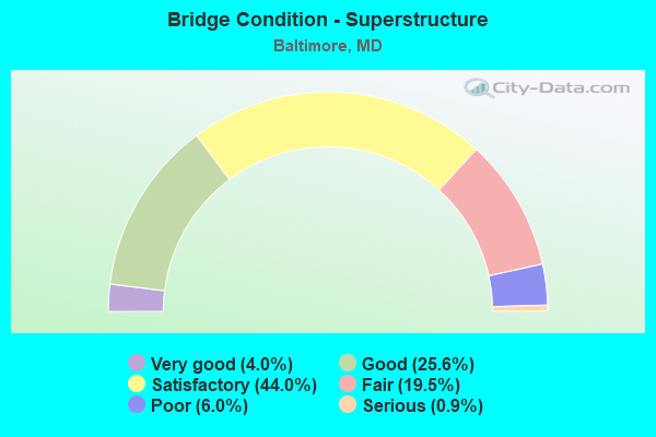
- Bridge Condition - Superstructure
- 4.0%Very good
- 25.6%Good
- 44.0%Satisfactory
- 19.5%Fair
- 6.0%Poor
- 0.9%Serious
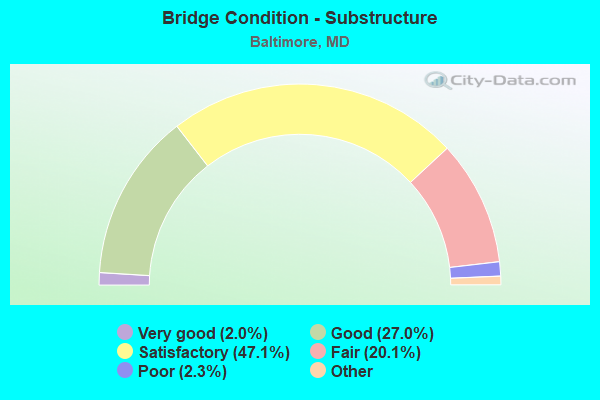
- Bridge Condition - Substructure
- 2.0%Very good
- 27.0%Good
- 47.1%Satisfactory
- 20.1%Fair
- 2.3%Poor
- 1.4%Serious
- 0.9%Critical
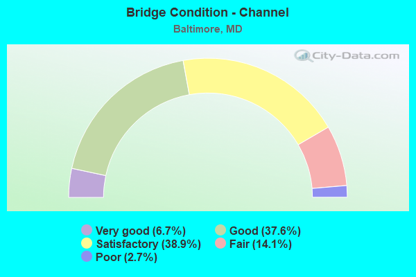
- Bridge Condition - Channel
- 6.7%Very good
- 37.6%Good
- 38.9%Satisfactory
- 14.1%Fair
- 2.7%Poor
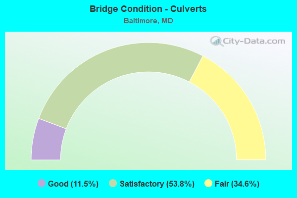
- Bridge Condition - Culverts
- 11.5%Good
- 53.8%Satisfactory
- 34.6%Fair
Find on map >> Show street view
Structure Number: 200000BC310301, Location: 0.4 MI N OF NORTH AVE (Lat: 39.317250, Lng: -76.630511), Route carried "on" structure: Ramp Interstate 83, Year Built: 1959, Year Reconstructed: 1988, Status: Open, Structure Length: 14.17m (46.49ft), Average Daily Traffic: 23,600 (year 2007), Truck Traffic: 10%, Average Future Daily Traffic: 29,400 (year 2027), Design Load: HS 20, Features Intersected: I-83 RAMP 'E'
Minimum Vertical Clearance: 30+ m (98+ ft), Kilometerpoint: 2.043, Lanes on structure: 1, Lanes under structure: 12, Base Highway Network: Yes, Owner: City or Municipal Highway Agency, Approaching Roadway Width: 7.3m (24.0ft), Material/Design: Steel, Design/Construction: Stringer/Multi-beam, Number Of Spans In Main Unit: 6, Length of Maximum Span: 32.3m (106.0ft), Curb-To-Curb Width: 7.3m (24.0ft), Out-to-Out Width: 8.4m (27.6ft)
Condition: Deck: Good, Superstructure: Good, Substructure: Fair, Inventory Rating: 64.9 metric tons, Method Used To Determine Inventory Rating: Load Factor (LF), Structural Evaluation: Somewhat better than minimum adequacy, Deck Geometry: Better than present minimum criteria, Underclear: Meets minimum limits, Approach Roadway Alignment: Equal to present minimum criteria, Length Of Structure Improvement: 14.17m (46.49ft), Designated Inspection Frequency: Every 24 months, Inspection Date: April 2020, Bridge Improvement Cost: $43,000, Total Project Cost: $43,000, Deck Structure Type: Concrete Cast-file-Place, Wearing Surface/Protective System: Wearing Surface: Integral Concrete
Find on map >> Show street view
Structure Number: 200000BC310401, Location: 29TH ST AT I-83 (Lat: 39.537589, Lng: -77.058883), Route carried "on" structure: Ramp Interstate 83, Year Built: 1959, Year Reconstructed: 1988, Status: Open, Structure Length: 10.39m (34.09ft), Average Daily Traffic: 19,035 (year 2020), Truck Traffic: 8%, Average Future Daily Traffic: 23,335 (year 2040), Design Load: HS 20, Features Intersected: I-83 NB, Facility Carried by Structure: ON RAMP 29TH STREE
Minimum Vertical Clearance: 30+ m (98+ ft), Kilometerpoint: 0.917, Lanes on structure: 1, Lanes under structure: 1, Owner: City or Municipal Highway Agency, Approaching Roadway Width: 10.7m (35.1ft), Material/Design: Steel, Design/Construction: Stringer/Multi-beam, Number Of Spans In Main Unit: 6, Length of Maximum Span: 20.1m (65.9ft), Curb-To-Curb Width: 7.0m (23.0ft), Out-to-Out Width: 9.1m (29.9ft)
Condition: Deck: Good, Superstructure: Satisfactory, Substructure: Fair, Operating Rating: 89.3 metric tons, Method Used To Determine Operating Rating: Load Factor (LF), Inventory Rating: 53.5 metric tons, Method Used To Determine Inventory Rating: Load Factor (LF), Structural Evaluation: Somewhat better than minimum adequacy, Deck Geometry: Equal to present minimum criteria, Approach Roadway Alignment: High priority of corrective action, Length Of Structure Improvement: 10.39m (34.09ft), Designated Inspection Frequency: Every 24 months, Inspection Date: October 2020, Bridge Improvement Cost: $31,000, Total Project Cost: $31,000, Deck Structure Type: Concrete Cast-file-Place, Wearing Surface/Protective System: Wearing Surface: Integral Concrete, Deck Protection: Epoxy Coated Reinforcing
Find on map >> Show street view
Structure Number: 200000BC310501, Location: 0.5 MI N OF NORTH AVE (Lat: 39.317783, Lng: -76.629892), Route carried "on" structure: Ramp City street 1612, Year Built: 1962, Year Reconstructed: 1988, Status: Open, Structure Length: 5.27m (17.29ft), Average Daily Traffic: 23,300 (year 2016), Truck Traffic: 5%, Average Future Daily Traffic: 27,594 (year 2033), Design Load: HS 20, Features Intersected: I-83, Facility Carried by Structure: 29TH STREET
Minimum Vertical Clearance: 30+ m (98+ ft), Kilometerpoint: 0.869, Lanes on structure: 3, Lanes under structure: 6, Owner: City or Municipal Highway Agency, Approaching Roadway Width: 12.2m (40.0ft), Skew: 3 degrees, Material/Design: Steel, Design/Construction: Stringer/Multi-beam, Number Of Spans In Main Unit: 3, Length of Maximum Span: 27.1m (88.9ft), Curb or Sidewalk Widths: Left: 1.5m (4.9ft), Right: 1.5m (4.9ft), Curb-To-Curb Width: 7.3m (24.0ft), Out-to-Out Width: 10.8m (35.4ft)
Condition: Deck: Good, Superstructure: Satisfactory, Substructure: Fair, Operating Rating: 87.1 metric tons, Method Used To Determine Operating Rating: Load Factor (LF), Inventory Rating: 52.2 metric tons, Method Used To Determine Inventory Rating: Load Factor (LF), Structural Evaluation: Somewhat better than minimum adequacy, Deck Geometry: High priority of replacement, Underclear: Meets minimum limits, Approach Roadway Alignment: Equal to present minimum criteria, Length Of Structure Improvement: 5.15m (16.90ft), Designated Inspection Frequency: Every 24 months, Inspection Date: April 2020, Bridge Improvement Cost: $6,000, Roadway Improvement Cost: $23,000, Total Project Cost: $29,000, Deck Structure Type: Concrete Cast-file-Place, Wearing Surface/Protective System: Wearing Surface: Monolithic Concrete, Deck Protection: Epoxy Coated Reinforcing
Find on map >> Show street view
Structure Number: 200000BC310601, Location: 0.4 MI N OF NORTH AVE (Lat: 39.317142, Lng: -76.630658), Route carried "on" structure: Ramp Interstate 83, Year Built: 1961, Year Reconstructed: 1988, Status: Open, Structure Length: 12.68m (41.60ft), Average Daily Traffic: 7,830 (year 2016), Truck Traffic: 10%, Average Future Daily Traffic: 9,273 (year 2033), Design Load: HS 20, Features Intersected: I-83
Minimum Vertical Clearance: 30+ m (98+ ft), Kilometerpoint: 2.043, Lanes on structure: 1, Lanes under structure: 9, Base Highway Network: Yes, Owner: City or Municipal Highway Agency, Approaching Roadway Width: 6.7m (22.0ft), Material/Design: Steel, Design/Construction: Stringer/Multi-beam, Number Of Spans In Main Unit: 7, Length of Maximum Span: 21.6m (70.9ft), Curb-To-Curb Width: 6.7m (22.0ft), Out-to-Out Width: 9.6m (31.5ft)
Condition: Deck: Good, Superstructure: Good, Substructure: Fair, Inventory Rating: 66.2 metric tons, Method Used To Determine Inventory Rating: Load Factor (LF), Structural Evaluation: Somewhat better than minimum adequacy, Deck Geometry: Equal to present minimum criteria, Underclear: High priority of corrective action, Approach Roadway Alignment: Equal to present minimum criteria, Length Of Structure Improvement: 12.68m (41.60ft), Designated Inspection Frequency: Every 24 months, Inspection Date: November 2020, Bridge Improvement Cost: $78,000, Roadway Improvement Cost: $24,000, Total Project Cost: $102,000 ( Estimate for 2016), Deck Structure Type: Concrete Cast-file-Place, Wearing Surface/Protective System: Wearing Surface: Monolithic Concrete
Find on map >> Show street view
Structure Number: 200000BC310701, Location: SB I-83 AT WB DRUID LK DR (Lat: 39.317600, Lng: -76.630428), Route carried "on" structure: Ramp Interstate 83, Year Built: 1959, Year Reconstructed: 1988, Status: Open, Structure Length: 5.43m (17.81ft), Average Daily Traffic: 26,030 (year 2016), Truck Traffic: 8%, Average Future Daily Traffic: 31,761 (year 2036), Design Load: HS 20, Features Intersected: DRUID LAKE DR WESTBOUND
Minimum Vertical Clearance: 30+ m (98+ ft), Kilometerpoint: 2.043, Lanes on structure: 1, Base Highway Network: Yes, Owner: City or Municipal Highway Agency, Approaching Roadway Width: 11.9m (39.0ft), Material/Design: Steel, Design/Construction: Stringer/Multi-beam, Number Of Spans In Main Unit: 4, Length of Maximum Span: 20.4m (66.9ft), Curb-To-Curb Width: 7.6m (24.9ft), Out-to-Out Width: 8.6m (28.2ft)
Condition: Deck: Good, Superstructure: Good, Substructure: Fair, Operating Rating: 85.7 metric tons, Method Used To Determine Operating Rating: Load Factor (LF), Inventory Rating: 51.2 metric tons, Method Used To Determine Inventory Rating: Load Factor (LF), Structural Evaluation: Somewhat better than minimum adequacy, Deck Geometry: Better than present minimum criteria, Approach Roadway Alignment: Equal to present minimum criteria, Length Of Structure Improvement: 5.43m (17.81ft), Designated Inspection Frequency: Every 24 months, Inspection Date: March 2020, Bridge Improvement Cost: $22,000, Roadway Improvement Cost: $8,000, Total Project Cost: $30,000 ( Estimate for 2018), Deck Structure Type: Concrete Cast-file-Place, Wearing Surface/Protective System: Wearing Surface: Monolithic Concrete, Deck Protection: Epoxy Coated Reinforcing
Find on map >> Show street view
Structure Number: 200000BC310801, Location: 0.5 MI N OF NORTH AVENUE (Lat: 4.555272, Lng: -8.108272), Route carried "on" structure: Interstate 83, Year Built: 1959, Year Reconstructed: 1988, Status: Open, Structure Length: 2.77m (9.09ft), Average Daily Traffic: 63,086 (year 2020), Truck Traffic: 8%, Average Future Daily Traffic: 78,524 (year 2042), Design Load: HS 20, Features Intersected: PUMPING STATION
Minimum Vertical Clearance: 30+ m (98+ ft), Kilometerpoint: 2.043, Lanes on structure: 4, Owner: City or Municipal Highway Agency, Approaching Roadway Width: 16.8m (55.1ft), Material/Design: Steel, Design/Construction: Stringer/Multi-beam, Number Of Spans In Main Unit: 1, Length of Maximum Span: 26.5m (86.9ft), Curb-To-Curb Width: 15.0m (49.2ft), Out-to-Out Width: 23.6m (77.4ft)
Condition: Deck: Good, Superstructure: Satisfactory, Substructure: Satisfactory, Operating Rating: 59.9 metric tons, Method Used To Determine Operating Rating: Field evaluation and documented engineering judgment, Inventory Rating: 29.0 metric tons, Method Used To Determine Inventory Rating: Field evaluation and documented engineering judgment, Structural Evaluation: Equal to present minimum criteria, Deck Geometry: High priority of replacement, Approach Roadway Alignment: Equal to present desirable criteria, Length Of Structure Improvement: 2.77m (9.09ft), Designated Inspection Frequency: Every 12 months, Inspection Date: January 2022, Bridge Improvement Cost: $24,000, Roadway Improvement Cost: $5,000, Total Project Cost: $29,000, Deck Structure Type: Concrete Cast-file-Place, Wearing Surface/Protective System: Wearing Surface: Monolithic Concrete, Deck Protection: Epoxy Coated Reinforcing
Find on map >> Show street view
Structure Number: 200000BC310901, Location: 0.9 MI N OF NORTH AVE (Lat: 39.325547, Lng: -76.633508), Route carried "on" structure: Ramp Interstate 83, Year Built: 1957, Year Reconstructed: 1987, Status: Open, Structure Length: 3.02m (9.91ft), Average Daily Traffic: 25,265 (year 2013), Truck Traffic: 10%, Average Future Daily Traffic: 30,829 (year 2033), Design Load: H 20, Features Intersected: MTA LIGHT RAIL
Minimum Vertical Clearance: 30+ m (98+ ft), Kilometerpoint: 2.043, Lanes on structure: 1, Owner: City or Municipal Highway Agency, Approaching Roadway Width: 9.8m (32.2ft), Skew: 2 degrees, Material/Design: Steel, Design/Construction: Stringer/Multi-beam, Number Of Spans In Main Unit: 1, Length of Maximum Span: 29.0m (95.1ft), Curb-To-Curb Width: 9.8m (32.2ft), Out-to-Out Width: 10.7m (35.1ft)
Condition: Deck: Good, Superstructure: Good, Substructure: Satisfactory, Operating Rating: 69.8 metric tons, Method Used To Determine Operating Rating: Load Factor (LF), Inventory Rating: 35.4 metric tons, Method Used To Determine Inventory Rating: Load Factor (LF), Structural Evaluation: Equal to present minimum criteria, Deck Geometry: Superior to present desirable criteria, Underclear: Equal to present minimum criteria, Approach Roadway Alignment: Equal to present minimum criteria, Length Of Structure Improvement: 3.02m (9.91ft), Designated Inspection Frequency: Every 24 months, Inspection Date: November 2021, Bridge Improvement Cost: $3,000, Roadway Improvement Cost: $14,000, Total Project Cost: $17,000, Deck Structure Type: Concrete Cast-file-Place, Wearing Surface/Protective System: Wearing Surface: Integral Concrete
Find on map >> Show street view
Structure Number: 200000BC311001, Location: OFF RAMP OVER FALLS RD (Lat: 39.327028, Lng: -76.632778), Route carried "on" structure: Ramp Interstate 83, Year Built: 1960, Year Reconstructed: 1987, Status: Open, Structure Length: 2.50m (8.20ft), Average Daily Traffic: 25,265 (year 2013), Truck Traffic: 8%, Average Future Daily Traffic: 30,829 (year 2033), Design Load: HS 20, Features Intersected: MD 25, FALLS RD
Minimum Vertical Clearance: 30+ m (98+ ft), Kilometerpoint: 2.043, Lanes on structure: 1, Lanes under structure: 2, Owner: City or Municipal Highway Agency, Approaching Roadway Width: 9.8m (32.2ft), Skew: 4 degrees, Material/Design: Steel, Design/Construction: Stringer/Multi-beam, Number Of Spans In Main Unit: 1, Length of Maximum Span: 23.8m (78.1ft), Curb-To-Curb Width: 9.8m (32.2ft), Out-to-Out Width: 10.7m (35.1ft)
Condition: Deck: Good, Superstructure: Satisfactory, Substructure: Fair, Inventory Rating: 67.1 metric tons, Method Used To Determine Inventory Rating: Load Factor (LF), Structural Evaluation: Somewhat better than minimum adequacy, Deck Geometry: Superior to present desirable criteria, Underclear: Meets minimum limits, Approach Roadway Alignment: Equal to present desirable criteria, Length Of Structure Improvement: 2.50m (8.20ft), Designated Inspection Frequency: Every 24 months, Inspection Date: May 2020, Bridge Improvement Cost: $17,000, Roadway Improvement Cost: $6,000, Total Project Cost: $23,000, Deck Structure Type: Concrete Cast-file-Place, Wearing Surface/Protective System: Deck Protection: Epoxy Coated Reinforcing
Find on map >> Show street view
Structure Number: 200000BC311101, Location: ON RAMP, JFX-FALLS RD (Lat: 39.325756, Lng: -76.633617), Route carried "on" structure: Ramp Interstate 83, Year Built: 1960, Year Reconstructed: 1987, Status: Open, Structure Length: 6.95m (22.80ft), Average Daily Traffic: 6,335 (year 2016), Truck Traffic: 10%, Average Future Daily Traffic: 9,413 (year 2036), Design Load: HS 20, Features Intersected: MTA, JONES FALLS, & C. M, Facility Carried by Structure: FALLS ROAD
Minimum Vertical Clearance: 30+ m (98+ ft), Kilometerpoint: 2.043, Lanes on structure: 2, Lanes under structure: 2, Owner: City or Municipal Highway Agency, Approaching Roadway Width: 19.5m (64.0ft), Skew: 31 degrees, Material/Design: Steel, Design/Construction: Stringer/Multi-beam, Number Of Spans In Main Unit: 3, Length of Maximum Span: 22.6m (74.1ft), Curb-To-Curb Width: 19.5m (64.0ft), Out-to-Out Width: 20.5m (67.3ft)
Condition: Deck: Satisfactory, Superstructure: Satisfactory, Substructure: Satisfactory, Channel: Satisfactory, Inventory Rating: 58.0 metric tons, Method Used To Determine Inventory Rating: Load Factor (LF), Structural Evaluation: Equal to present minimum criteria, Deck Geometry: Superior to present desirable criteria, Underclear: Equal to present minimum criteria, Waterway Adequacy: Superior to present desirable criteria, Approach Roadway Alignment: Equal to present minimum criteria, Length Of Structure Improvement: 6.95m (22.80ft), Designated Inspection Frequency: Every 24 months, Inspection Date: September 2020, Bridge Improvement Cost: $8,000, Roadway Improvement Cost: $32,000, Total Project Cost: $40,000, Deck Structure Type: Concrete Cast-file-Place, Wearing Surface/Protective System: Wearing Surface: Monolithic Concrete
Find on map >> Show street view
Structure Number: 200000BC311201, Location: JFX OVER FALLS RD ON RAMP (Lat: 39.325028, Lng: -76.634333), Route carried "on" structure: Interstate 83, Year Built: 1959, Year Reconstructed: 1987, Status: Open, Structure Length: 3.60m (11.81ft), Average Daily Traffic: 139,645 (year 2021), Truck Traffic: 8%, Average Future Daily Traffic: 223,743 (year 2041), Design Load: HS 20, Features Intersected: ON RAMP FROM FALLS ROAD
Minimum Vertical Clearance: 30+ m (98+ ft), Kilometerpoint: 2.043, Lanes on structure: 6, Lanes under structure: 1, Base Highway Network: Yes, Owner: City or Municipal Highway Agency, Approaching Roadway Width: 32.0m (105.0ft), Skew: 33 degrees, Material/Design: Steel, Design/Construction: Stringer/Multi-beam, Number Of Spans In Main Unit: 2, Length of Maximum Span: 21.0m (68.9ft), Curb-To-Curb Width: 32.0m (105.0ft), Out-to-Out Width: 33.0m (108.3ft)
Condition: Deck: Good, Superstructure: Fair, Substructure: Satisfactory, Inventory Rating: 67.1 metric tons, Method Used To Determine Inventory Rating: Load Factor (LF), Structural Evaluation: Somewhat better than minimum adequacy, Deck Geometry: Superior to present desirable criteria, Underclear: High priority of corrective action, Approach Roadway Alignment: Equal to present desirable criteria, Length Of Structure Improvement: 3.60m (11.81ft), Designated Inspection Frequency: Every 12 months, Inspection Date: November 2021, Bridge Improvement Cost: $34,000, Roadway Improvement Cost: $6,000, Total Project Cost: $40,000, Deck Structure Type: Concrete Cast-file-Place, Wearing Surface/Protective System: Wearing Surface: Monolithic Concrete
Find on map >> Show street view
Structure Number: 200000BC311301, Location: 1.1 MI S OF COLD SPRING L (Lat: 39.328428, Lng: -76.641178), Route carried "on" structure: Interstate 83, Year Built: 1959, Year Reconstructed: 1988, Status: Open, Structure Length: 23.80m (78.08ft), Average Daily Traffic: 23,800 (year 2007), Truck Traffic: 10%, Average Future Daily Traffic: 29,600 (year 2027), Design Load: HS 20, Features Intersected: MTA AND JONES FALLS
Minimum Vertical Clearance: 30+ m (98+ ft), Kilometerpoint: 2.043, Lanes on structure: 6, Base Highway Network: Yes, Owner: City or Municipal Highway Agency, Approaching Roadway Width: 15.9m (52.2ft), Skew: 30 degrees, Material/Design: Steel, Design/Construction: Girder and Floorbeam System, Number Of Spans In Main Unit: 8, Number Of Approach Spans: 6, Length of Maximum Span: 53.0m (173.9ft), Curb-To-Curb Width: 32.3m (106.0ft), Out-to-Out Width: 34.2m (112.2ft)
Condition: Deck: Satisfactory, Superstructure: Fair, Substructure: Fair, Channel: Good, Operating Rating: 50.8 metric tons, Method Used To Determine Operating Rating: Field evaluation and documented engineering judgment, Inventory Rating: 29.0 metric tons, Method Used To Determine Inventory Rating: Field evaluation and documented engineering judgment, Structural Evaluation: Somewhat better than minimum adequacy, Deck Geometry: Superior to present desirable criteria, Underclear: Equal to present minimum criteria, Waterway Adequacy: Superior to present desirable criteria, Approach Roadway Alignment: Equal to present minimum criteria, Length Of Structure Improvement: 23.59m (77.40ft), Designated Inspection Frequency: Every 12 months, Critical Feature Inspection Frequency: Every 12 months, Inspection Date: October 2021, Critical Feature Inspection Date: October 2021, Bridge Improvement Cost: $837,000, Total Project Cost: $837,000, Deck Structure Type: Concrete Cast-file-Place, Wearing Surface/Protective System: Wearing Surface: Monolithic Concrete
Find on map >> Show street view
Structure Number: 200000BC311401, Location: I-83 OVER JF & UNION AVE (Lat: 39.334222, Lng: -76.644361), Route carried "on" structure: Interstate 83, Year Built: 1959, Year Reconstructed: 1987, Status: Open, Structure Length: 56.24m (184.51ft), Average Daily Traffic: 93,178 (year 2021), Truck Traffic: 8%, Average Future Daily Traffic: 116,015 (year 2043), Design Load: HS 20, Features Intersected: JONES FALLS & UNION AVE
Minimum Vertical Clearance: 30+ m (98+ ft), Kilometerpoint: 2.043, Lanes on structure: 6, Lanes under structure: 2, Base Highway Network: Yes, Owner: City or Municipal Highway Agency, Approaching Roadway Width: 32.3m (106.0ft), Skew: 10 degrees, Material/Design: Concrete continuous, Design/Construction: Slab, Number Of Spans In Main Unit: 33, Length of Maximum Span: 19.5m (64.0ft), Curb-To-Curb Width: 32.3m (106.0ft), Out-to-Out Width: 34.2m (112.2ft)
Condition: Deck: Fair, Superstructure: Fair, Substructure: Fair, Channel: Fair, Operating Rating: 47.2 metric tons, Method Used To Determine Operating Rating: Load Factor (LF), Inventory Rating: 28.1 metric tons, Method Used To Determine Inventory Rating: Load Factor (LF), Structural Evaluation: Somewhat better than minimum adequacy, Deck Geometry: Superior to present desirable criteria, Underclear: Meets minimum limits, Waterway Adequacy: Equal to present desirable criteria, Approach Roadway Alignment: Equal to present desirable criteria, Length Of Structure Improvement: 56.24m (184.51ft), Designated Inspection Frequency: Every 12 months, Inspection Date: March 2021, Bridge Improvement Cost: $526,000, Total Project Cost: $526,000, Deck Structure Type: Concrete Cast-file-Place, Wearing Surface/Protective System: Wearing Surface: Integral Concrete
Find on map >> Show street view
Structure Number: 200000BC311501, Location: 0.6 MI S COLD SPRING LN (Lat: 39.338722, Lng: -76.647622), Route carried "on" structure: Interstate 83, Year Built: 1959, Year Reconstructed: 1987, Status: Open, Structure Length: 36.55m (119.91ft), Average Daily Traffic: 105,600 (year 2016), Truck Traffic: 10%, Average Future Daily Traffic: 131,400 (year 2036), Design Load: HS 20, Features Intersected: JONES FALLS (MI. 7.1 TO
Minimum Vertical Clearance: 30+ m (98+ ft), Kilometerpoint: 6.677, Lanes on structure: 6, Owner: City or Municipal Highway Agency, Approaching Roadway Width: 31.4m (103.0ft), Skew: 30 degrees, Material/Design: Concrete continuous, Design/Construction: Slab, Number Of Spans In Main Unit: 21, Length of Maximum Span: 23.8m (78.1ft), Curb-To-Curb Width: 30.5m (100.1ft), Out-to-Out Width: 32.3m (106.0ft)
Condition: Deck: Fair, Superstructure: Fair, Substructure: Fair, Channel: Satisfactory, Operating Rating: 49.0 metric tons, Method Used To Determine Operating Rating: Field evaluation and documented engineering judgment, Inventory Rating: 32.7 metric tons, Method Used To Determine Inventory Rating: Field evaluation and documented engineering judgment, Structural Evaluation: Somewhat better than minimum adequacy, Deck Geometry: Superior to present desirable criteria, Underclear: Somewhat better than minimum adequacy, Waterway Adequacy: Equal to present desirable criteria, Approach Roadway Alignment: Equal to present desirable criteria, Length Of Structure Improvement: 36.55m (119.91ft), Designated Inspection Frequency: Every 12 months, Inspection Date: January 2021, Bridge Improvement Cost: $190,000, Roadway Improvement Cost: $3,000, Total Project Cost: $193,000, Deck Structure Type: Concrete Cast-file-Place, Wearing Surface/Protective System: Wearing Surface: Monolithic Concrete
Find on map >> Show street view
Structure Number: 200000BC311601, Location: ON RAMP SB JFX I-83 (Lat: 39.344928, Lng: -76.648269), Route carried "on" structure: Ramp Interstate 83, Year Built: 1962, Year Reconstructed: 1990, Status: Open, Structure Length: 6.55m (21.49ft), Average Daily Traffic: 23,800 (year 2017), Truck Traffic: 8%, Average Future Daily Traffic: 29,600 (year 2037), Design Load: HS 20, Features Intersected: MTA LIGHT RAIL, Facility Carried by Structure: COLDSPRING RAMP TO
Minimum Vertical Clearance: 30+ m (98+ ft), Kilometerpoint: 2.043, Lanes on structure: 1, Owner: City or Municipal Highway Agency, Approaching Roadway Width: 6.4m (21.0ft), Skew: 9 degrees, Material/Design: Steel continuous, Design/Construction: Stringer/Multi-beam, Number Of Spans In Main Unit: 3, Length of Maximum Span: 27.1m (88.9ft), Curb-To-Curb Width: 6.4m (21.0ft), Out-to-Out Width: 7.4m (24.3ft)
Condition: Deck: Satisfactory, Superstructure: Good, Substructure: Satisfactory, Operating Rating: 47.6 metric tons, Method Used To Determine Operating Rating: Load Factor (LF), Inventory Rating: 28.6 metric tons, Method Used To Determine Inventory Rating: Load Factor (LF), Structural Evaluation: Equal to present minimum criteria, Deck Geometry: Somewhat better than minimum adequacy, Underclear: Equal to present minimum criteria, Approach Roadway Alignment: Equal to present minimum criteria, Length Of Structure Improvement: 6.55m (21.49ft), Designated Inspection Frequency: Every 12 months, Inspection Date: November 2021, Bridge Improvement Cost: $9,000, Total Project Cost: $9,000, Deck Structure Type: Concrete Cast-file-Place, Wearing Surface/Protective System: Deck Protection: Epoxy Coated Reinforcing
Find on map >> Show street view
Structure Number: 200000BC311701, Location: OFFRAMP SB JFX @ CLDSPRNG (Lat: 39.346217, Lng: -76.648614), Route carried "on" structure: Ramp Interstate 83, Year Built: 1962, Year Reconstructed: 1990, Status: Open, Structure Length: 6.89m (22.60ft), Average Daily Traffic: 5,149 (year 2018), Truck Traffic: 8%, Average Future Daily Traffic: 6,410 (year 2038), Design Load: HS 20, Features Intersected: MTA LIGHT RAIL
Minimum Vertical Clearance: 30+ m (98+ ft), Kilometerpoint: 2.043, Lanes on structure: 1, Owner: City or Municipal Highway Agency, Approaching Roadway Width: 6.7m (22.0ft), Skew: 9 degrees, Material/Design: Steel continuous, Design/Construction: Stringer/Multi-beam, Number Of Spans In Main Unit: 3, Length of Maximum Span: 34.1m (111.9ft), Curb-To-Curb Width: 6.7m (22.0ft), Out-to-Out Width: 7.7m (25.3ft)
Condition: Deck: Good, Superstructure: Good, Substructure: Good, Operating Rating: 84.8 metric tons, Method Used To Determine Operating Rating: Load Factor (LF), Inventory Rating: 50.8 metric tons, Method Used To Determine Inventory Rating: Load Factor (LF), Structural Evaluation: Better than present minimum criteria, Deck Geometry: Equal to present minimum criteria, Underclear: Meets minimum limits, Approach Roadway Alignment: Equal to present minimum criteria, Length Of Structure Improvement: 6.89m (22.60ft), Designated Inspection Frequency: Every 24 months, Inspection Date: October 2020, Bridge Improvement Cost: $18,000, Roadway Improvement Cost: $6,000, Total Project Cost: $24,000, Deck Structure Type: Concrete Cast-file-Place, Wearing Surface/Protective System: Deck Protection: Epoxy Coated Reinforcing
Find on map >> Show street view
Structure Number: 200000BC311801, Location: 0.3 MI N COLD SPRING LANE (Lat: 39.348067, Lng: -76.646800), Route carried "on" structure: Interstate 83, Year Built: 1962, Year Reconstructed: 1987, Status: Open, Structure Length: 5.49m (18.01ft), Average Daily Traffic: 23,800 (year 2007), Truck Traffic: 10%, Average Future Daily Traffic: 29,600 (year 2030), Design Load: HS 20, Features Intersected: JONES FALLS
Minimum Vertical Clearance: 30+ m (98+ ft), Kilometerpoint: 2.043, Lanes on structure: 7, Base Highway Network: Yes, Owner: City or Municipal Highway Agency, Approaching Roadway Width: 34.7m (113.8ft), Skew: 34 degrees, Material/Design: Steel, Design/Construction: Stringer/Multi-beam, Number Of Spans In Main Unit: 3, Length of Maximum Span: 22.3m (73.2ft), Curb-To-Curb Width: 26.2m (86.0ft), Out-to-Out Width: 33.3m (109.3ft)
Condition: Deck: Satisfactory, Superstructure: Satisfactory, Substructure: Good, Channel: Good, Operating Rating: 51.7 metric tons, Method Used To Determine Operating Rating: Load Factor (LF), Inventory Rating: 30.8 metric tons, Method Used To Determine Inventory Rating: Load Factor (LF), Structural Evaluation: Equal to present minimum criteria, Deck Geometry: High priority of replacement, Waterway Adequacy: Equal to present desirable criteria, Approach Roadway Alignment: Equal to present desirable criteria, Length Of Structure Improvement: 5.49m (18.01ft), Designated Inspection Frequency: Every 12 months, Inspection Date: January 2021, Bridge Improvement Cost: $94,000, Roadway Improvement Cost: $10,000, Total Project Cost: $113,000, Deck Structure Type: Concrete Cast-file-Place, Wearing Surface/Protective System: Wearing Surface: Monolithic Concrete
Find on map >> Show street view
Structure Number: 200000BC311901, Location: NB I-83 OFF RAMP (Lat: 39.358347, Lng: -76.649669), Route carried "on" structure: Ramp Interstate 83, Year Built: 1959, Year Reconstructed: 1987, Status: Open, Structure Length: 9.85m (32.32ft), Average Daily Traffic: 23,800 (year 2014), Truck Traffic: 8%, Average Future Daily Traffic: 29,600 (year 2036), Design Load: HS 20, Features Intersected: JONES FALLS
Minimum Vertical Clearance: 30+ m (98+ ft), Kilometerpoint: 2.043, Lanes on structure: 1, Owner: City or Municipal Highway Agency, Approaching Roadway Width: 7.3m (24.0ft), Skew: 7 degrees, Material/Design: Steel, Design/Construction: Stringer/Multi-beam, Number Of Spans In Main Unit: 3, Length of Maximum Span: 27.1m (88.9ft), Curb-To-Curb Width: 7.3m (24.0ft), Out-to-Out Width: 8.3m (27.2ft)
Condition: Deck: Satisfactory, Superstructure: Satisfactory, Substructure: Satisfactory, Channel: Satisfactory, Operating Rating: 87.5 metric tons, Method Used To Determine Operating Rating: Load Factor (LF), Inventory Rating: 52.6 metric tons, Method Used To Determine Inventory Rating: Load Factor (LF), Structural Evaluation: Equal to present minimum criteria, Deck Geometry: Better than present minimum criteria, Waterway Adequacy: Equal to present minimum criteria, Approach Roadway Alignment: Equal to present minimum criteria, Length Of Structure Improvement: 9.85m (32.32ft), Designated Inspection Frequency: Every 24 months, Inspection Date: May 2020, Bridge Improvement Cost: $87,000, Roadway Improvement Cost: $5,000, Total Project Cost: $92,000, Deck Structure Type: Concrete Cast-file-Place, Wearing Surface/Protective System: Deck Protection: Epoxy Coated Reinforcing
Find on map >> Show street view
Structure Number: 200000BC312001, Location: ON RAMP SB I-83 (Lat: 39.360036, Lng: -76.651169), Route carried "on" structure: Ramp Interstate 83, Year Built: 1959, Year Reconstructed: 1987, Status: Open, Structure Length: 1.62m (5.31ft), Average Daily Traffic: 23,800 (year 2014), Truck Traffic: 8%, Average Future Daily Traffic: 29,600 (year 2036), Design Load: HS 20, Features Intersected: MTA LIGHT RAIL, Facility Carried by Structure: NORTHERN PKWY ON-R
Minimum Vertical Clearance: 30+ m (98+ ft), Kilometerpoint: 2.043, Lanes on structure: 1, Owner: City or Municipal Highway Agency, Approaching Roadway Width: 7.6m (24.9ft), Skew: 5 degrees, Material/Design: Steel, Design/Construction: Stringer/Multi-beam, Number Of Spans In Main Unit: 1, Length of Maximum Span: 14.3m (46.9ft), Curb-To-Curb Width: 7.6m (24.9ft), Out-to-Out Width: 8.6m (28.2ft)
Condition: Deck: Satisfactory, Superstructure: Good, Substructure: Fair, Inventory Rating: 56.2 metric tons, Method Used To Determine Inventory Rating: Load Factor (LF), Structural Evaluation: Somewhat better than minimum adequacy, Deck Geometry: Better than present minimum criteria, Underclear: High priority of corrective action, Approach Roadway Alignment: Equal to present minimum criteria, Length Of Structure Improvement: 1.62m (5.31ft), Designated Inspection Frequency: Every 24 months, Inspection Date: May 2020, Bridge Improvement Cost: $35,000, Roadway Improvement Cost: $3,000, Total Project Cost: $38,000, Deck Structure Type: Concrete Cast-file-Place, Wearing Surface/Protective System: Deck Protection: Epoxy Coated Reinforcing
Find on map >> Show street view
Structure Number: 200000BC312101, Location: I-83 AT NORTHERN PKWY (Lat: 39.360844, Lng: -76.650906), Route carried "on" structure: Ramp Interstate 83, Year Built: 1962, Year Reconstructed: 1988, Status: Open, Structure Length: 4.02m (13.19ft), Average Daily Traffic: 23,357 (year 2020), Truck Traffic: 8%, Average Future Daily Traffic: 29,090 (year 2042), Design Load: HS 20, Features Intersected: RELIEF TO NORTHERN PARKW
Minimum Vertical Clearance: 30+ m (98+ ft), Kilometerpoint: 2.043, Lanes on structure: 3, Owner: City or Municipal Highway Agency, Approaching Roadway Width: 16.8m (55.1ft), Skew: 10 degrees, Material/Design: Steel, Design/Construction: Stringer/Multi-beam, Number Of Spans In Main Unit: 4, Length of Maximum Span: 20.4m (66.9ft), Curb or Sidewalk Widths: Left: 0.0m, Right: 0.1m (0.3ft), Curb-To-Curb Width: 18.2m (59.7ft), Out-to-Out Width: 19.6m (64.3ft)
Condition: Deck: Good, Superstructure: Good, Substructure: Good, Operating Rating: 84.8 metric tons, Method Used To Determine Operating Rating: Load Factor (LF), Inventory Rating: 50.8 metric tons, Method Used To Determine Inventory Rating: Load Factor (LF), Structural Evaluation: Better than present minimum criteria, Deck Geometry: Superior to present desirable criteria, Approach Roadway Alignment: Equal to present desirable criteria, Length Of Structure Improvement: 4.33m (14.21ft), Designated Inspection Frequency: Every 24 months, Inspection Date: September 2020, Bridge Improvement Cost: $15,000, Roadway Improvement Cost: $4,000, Total Project Cost: $19,000, Deck Structure Type: Concrete Cast-file-Place, Wearing Surface/Protective System: Deck Protection: Epoxy Coated Reinforcing
Find on map >> Show street view
Structure Number: 200000BC312201, Location: NB I-83 TO WB N PKWY (Lat: 39.362150, Lng: -76.649500), Route carried "on" structure: Ramp Interstate 83, Year Built: 1959, Year Reconstructed: 1987, Status: Open, Structure Length: 4.60m (15.09ft), Average Daily Traffic: 23,800 (year 2014), Truck Traffic: 5%, Average Future Daily Traffic: 29,600 (year 2036), Design Load: HS 20, Features Intersected: JONES FALLS
Minimum Vertical Clearance: 30+ m (98+ ft), Kilometerpoint: 2.043, Lanes on structure: 1, Owner: City or Municipal Highway Agency, Approaching Roadway Width: 7.6m (24.9ft), Skew: 1 degrees, Material/Design: Steel, Design/Construction: Stringer/Multi-beam, Number Of Spans In Main Unit: 3, Length of Maximum Span: 19.2m (63.0ft), Curb-To-Curb Width: 7.5m (24.6ft), Out-to-Out Width: 8.6m (28.2ft)
Condition: Deck: Good, Superstructure: Good, Substructure: Satisfactory, Channel: Satisfactory, Inventory Rating: 55.8 metric tons, Method Used To Determine Inventory Rating: Load Factor (LF), Structural Evaluation: Equal to present minimum criteria, Deck Geometry: Better than present minimum criteria, Waterway Adequacy: Superior to present desirable criteria, Approach Roadway Alignment: High priority of corrective action, Length Of Structure Improvement: 4.60m (15.09ft), Designated Inspection Frequency: Every 24 months, Inspection Date: November 2020, Bridge Improvement Cost: $35,000, Roadway Improvement Cost: $1,000, Total Project Cost: $36,000, Deck Structure Type: Concrete Cast-file-Place, Wearing Surface/Protective System: Wearing Surface: Monolithic Concrete
Find on map >> Show street view
Structure Number: 200000BC312301, Location: WB RAMP FROM N PKWY (Lat: 39.362469, Lng: -76.649772), Route carried "on" structure: Ramp Interstate 83, Year Built: 1959, Year Reconstructed: 1987, Status: Open, Structure Length: 5.97m (19.59ft), Average Daily Traffic: 5,350 (year 2014), Truck Traffic: 8%, Average Future Daily Traffic: 6,670 (year 2036), Design Load: HS 20, Features Intersected: I-83, Facility Carried by Structure: NORTHERN PKWY RAMP
Minimum Vertical Clearance: 4.57m (14.99ft), Kilometerpoint: 6.436, Lanes on structure: 1, Lanes under structure: 6, Owner: City or Municipal Highway Agency, Approaching Roadway Width: 7.3m (24.0ft), Skew: 3 degrees, Material/Design: Steel, Design/Construction: Stringer/Multi-beam, Number Of Spans In Main Unit: 3, Length of Maximum Span: 28.7m (94.2ft), Curb-To-Curb Width: 7.6m (24.9ft), Out-to-Out Width: 8.5m (27.9ft)
Condition: Deck: Good, Superstructure: Fair, Substructure: Satisfactory, Operating Rating: 34.5 metric tons, Method Used To Determine Operating Rating: Field evaluation and documented engineering judgment, Inventory Rating: 34.5 metric tons, Method Used To Determine Inventory Rating: Field evaluation and documented engineering judgment, Structural Evaluation: Somewhat better than minimum adequacy, Deck Geometry: Better than present minimum criteria, Underclear: Meets minimum limits, Approach Roadway Alignment: Equal to present minimum criteria, Length Of Structure Improvement: 5.97m (19.59ft), Designated Inspection Frequency: Every 24 months, Inspection Date: November 2020, Bridge Improvement Cost: $116,000, Roadway Improvement Cost: $8,000, Total Project Cost: $124,000, Deck Structure Type: Concrete Cast-file-Place, Wearing Surface/Protective System: Deck Protection: Epoxy Coated Reinforcing
Find on map >> Show street view
Structure Number: 200000BC312401, Location: NORTHRN PKWY RAMP TO I-83 (Lat: 39.362242, Lng: -76.648819), Route carried "on" structure: Ramp Interstate 83, Year Built: 1959, Year Reconstructed: 1987, Status: Open, Structure Length: 6.13m (20.11ft), Average Daily Traffic: 29,900 (year 2014), Truck Traffic: 8%, Average Future Daily Traffic: 39,060 (year 2036), Design Load: HS 20, Features Intersected: JONES FALLS, Facility Carried by Structure: ON-RAMP NORTHERN P
Minimum Vertical Clearance: 30+ m (98+ ft), Kilometerpoint: 6.436, Lanes on structure: 1, Owner: City or Municipal Highway Agency, Approaching Roadway Width: 7.3m (24.0ft), Skew: 2 degrees, Material/Design: Steel, Design/Construction: Stringer/Multi-beam, Number Of Spans In Main Unit: 4, Length of Maximum Span: 21.0m (68.9ft), Curb-To-Curb Width: 7.3m (24.0ft), Out-to-Out Width: 8.3m (27.2ft)
Condition: Deck: Good, Superstructure: Good, Substructure: Satisfactory, Channel: Satisfactory, Inventory Rating: 63.0 metric tons, Method Used To Determine Inventory Rating: Load Factor (LF), Structural Evaluation: Equal to present minimum criteria, Deck Geometry: Better than present minimum criteria, Waterway Adequacy: Superior to present desirable criteria, Approach Roadway Alignment: Equal to present minimum criteria, Length Of Structure Improvement: 6.13m (20.11ft), Designated Inspection Frequency: Every 24 months, Inspection Date: November 2020, Bridge Improvement Cost: $38,000, Roadway Improvement Cost: $9,000, Total Project Cost: $47,000, Deck Structure Type: Concrete Cast-file-Place, Wearing Surface/Protective System: Wearing Surface: Monolithic Concrete
Find on map >> Show street view
Structure Number: 200000BC312501, Location: 0.1 MI N OF KELLY AVE (Lat: 39.367622, Lng: -76.650647), Route carried "on" structure: Interstate 83, Year Built: 1959, Year Reconstructed: 1976, Status: Open, Structure Length: 2.93m (9.61ft), Average Daily Traffic: 29,900 (year 2014), Truck Traffic: 8%, Average Future Daily Traffic: 37,200 (year 2036), Design Load: HS 20, Features Intersected: WESTERN RUN
Minimum Vertical Clearance: 30+ m (98+ ft), Kilometerpoint: 6.436, Lanes on structure: 6, Owner: City or Municipal Highway Agency, Approaching Roadway Width: 32.3m (106.0ft), Skew: 12 degrees, Material/Design: Steel, Design/Construction: Stringer/Multi-beam, Number Of Spans In Main Unit: 1, Length of Maximum Span: 28.3m (92.8ft), Curb-To-Curb Width: 27.4m (89.9ft), Out-to-Out Width: 33.4m (109.6ft)
Condition: Deck: Satisfactory, Superstructure: Satisfactory, Substructure: Satisfactory, Channel: Good, Inventory Rating: 68.5 metric tons, Method Used To Determine Inventory Rating: Load Factor (LF), Structural Evaluation: Equal to present minimum criteria, Deck Geometry: Equal to present minimum criteria, Waterway Adequacy: Superior to present desirable criteria, Approach Roadway Alignment: Equal to present desirable criteria, Length Of Structure Improvement: 2.93m (9.61ft), Designated Inspection Frequency: Every 24 months, Inspection Date: July 2020, Bridge Improvement Cost: $147,000, Roadway Improvement Cost: $13,000, Total Project Cost: $160,000, Deck Structure Type: Concrete Cast-file-Place, Wearing Surface/Protective System: Deck Protection: Epoxy Coated Reinforcing
Find on map >> Show street view
Structure Number: 200000BC312701, Location: AT CITY LINE (Lat: 39.367136, Lng: -76.650447), Route carried "on" structure: Interstate 83, Year Built: 1962, Year Reconstructed: 1987, Status: Open, Structure Length: 26.64m (87.40ft), Average Daily Traffic: 29,900 (year 2018), Truck Traffic: 24%, Average Future Daily Traffic: 37,200 (year 2038), Design Load: HS 20, Features Intersected: MTA LIGHT RAIL
Minimum Vertical Clearance: 30+ m (98+ ft), Kilometerpoint: 6.436, Lanes on structure: 6, Owner: City or Municipal Highway Agency, Approaching Roadway Width: 31.1m (102.0ft), Skew: 30 degrees, Material/Design: Steel, Design/Construction: Stringer/Multi-beam, Number Of Spans In Main Unit: 14, Length of Maximum Span: 27.7m (90.9ft), Curb-To-Curb Width: 31.1m (102.0ft), Out-to-Out Width: 32.1m (105.3ft)
Condition: Deck: Good, Superstructure: Poor, Substructure: Serious, Operating Rating: 74.4 metric tons, Method Used To Determine Operating Rating: Load Factor (LF), Inventory Rating: 44.9 metric tons, Method Used To Determine Inventory Rating: Load Factor (LF), Structural Evaluation: High priority of corrective action, Deck Geometry: Superior to present desirable criteria, Underclear: Equal to present minimum criteria, Approach Roadway Alignment: Equal to present desirable criteria, Length Of Structure Improvement: 26.64m (87.40ft), Designated Inspection Frequency: Every 24 months, Inspection Date: Febuary 2020, Bridge Improvement Cost: $154,000, Roadway Improvement Cost: $8,000, Total Project Cost: $162,000, Deck Structure Type: Concrete Cast-file-Place, Wearing Surface/Protective System: Wearing Surface: Integral Concrete
Find on map >> Show street view
Structure Number: 200000BC312801, Location: COLDSPRING AT I-83 (Lat: 0.000108, Lng: -0.000214), Route carried "on" structure: Ramp Interstate 83, Year Built: 1962, Year Reconstructed: 1987, Status: Open, Structure Length: 5.67m (18.60ft), Average Daily Traffic: 34,824 (year 2020), Truck Traffic: 9%, Average Future Daily Traffic: 40,756 (year 2040), Design Load: HS 20, Features Intersected: JONES FALLS, Facility Carried by Structure: COLDSPRING LANE RA
Minimum Vertical Clearance: 30+ m (98+ ft), Kilometerpoint: 6.436, Lanes on structure: 1, Owner: City or Municipal Highway Agency, Approaching Roadway Width: 6.1m (20.0ft), Skew: 3 degrees, Material/Design: Steel, Design/Construction: Stringer/Multi-beam, Number Of Spans In Main Unit: 3, Length of Maximum Span: 21.0m (68.9ft), Curb-To-Curb Width: 6.1m (20.0ft), Out-to-Out Width: 8.3m (27.2ft)
Condition: Deck: Good, Superstructure: Fair, Substructure: Satisfactory, Channel: Very good, Inventory Rating: 65.3 metric tons, Method Used To Determine Inventory Rating: Load Factor (LF), Structural Evaluation: Somewhat better than minimum adequacy, Deck Geometry: Somewhat better than minimum adequacy, Waterway Adequacy: Equal to present desirable criteria, Approach Roadway Alignment: Equal to present desirable criteria, Length Of Structure Improvement: 5.67m (18.60ft), Designated Inspection Frequency: Every 24 months, Inspection Date: May 2020, Bridge Improvement Cost: $36,000, Roadway Improvement Cost: $2,000, Total Project Cost: $38,000, Deck Structure Type: Concrete Cast-file-Place, Wearing Surface/Protective System: Wearing Surface: Monolithic Concrete
Find on map >> Show street view
Structure Number: 200000BC312901, Location: NEAR COLDSPRING LANE (Lat: 39.315944, Lng: -76.628361), Route carried "on" structure: Ramp Interstate 83, Year Built: 1959, Year Reconstructed: 1990, Status: Open, Structure Length: 11.25m (36.91ft), Average Daily Traffic: 72,000 (year 2014), Truck Traffic: 7%, Average Future Daily Traffic: 89,600 (year 2036), Design Load: H 20, Features Intersected: I-83 BERM
Minimum Vertical Clearance: 30+ m (98+ ft), Kilometerpoint: 9.654, Lanes on structure: 1, Base Highway Network: Yes, Owner: City or Municipal Highway Agency, Approaching Roadway Width: 8.2m (26.9ft), Material/Design: Steel, Design/Construction: Stringer/Multi-beam, Number Of Spans In Main Unit: 6, Length of Maximum Span: 22.6m (74.1ft), Curb-To-Curb Width: 8.2m (26.9ft), Out-to-Out Width: 10.4m (34.1ft)
Condition: Deck: Good, Superstructure: Good, Substructure: Satisfactory, Inventory Rating: 67.6 metric tons, Method Used To Determine Inventory Rating: Load Factor (LF), Structural Evaluation: Equal to present minimum criteria, Deck Geometry: Superior to present desirable criteria, Approach Roadway Alignment: Equal to present minimum criteria, Length Of Structure Improvement: 9.63m (31.59ft), Designated Inspection Frequency: Every 24 months, Inspection Date: September 2020, Bridge Improvement Cost: $15,000, Roadway Improvement Cost: $15,000, Total Project Cost: $29,000 ( Estimate for 2014), Deck Structure Type: Concrete Cast-file-Place, Wearing Surface/Protective System: Wearing Surface: Monolithic Concrete
Find on map >> Show street view
Structure Number: 200000BC313001, Location: 0.30 MI N. OF NORTH AVE. (Lat: 39.315528, Lng: -76.628167), Route carried "on" structure: Ramp Interstate 83, Year Built: 1987, Status: Open, Structure Length: 31.88m (104.59ft), Average Daily Traffic: 16,217 (year 2020), Truck Traffic: 5%, Average Future Daily Traffic: 24,097 (year 2040), Features Intersected: STORAGE AREA
Minimum Vertical Clearance: 30+ m (98+ ft), Kilometerpoint: 0.000, Lanes on structure: 1, Base Highway Network: Yes, Owner: City or Municipal Highway Agency, Approaching Roadway Width: 7.0m (23.0ft), Material/Design: Steel continuous, Design/Construction: Stringer/Multi-beam, Number Of Spans In Main Unit: 16, Length of Maximum Span: 30.8m (101.0ft), Curb-To-Curb Width: 7.0m (23.0ft), Out-to-Out Width: 7.9m (25.9ft)
Condition: Deck: Satisfactory, Superstructure: Satisfactory, Substructure: Good, Operating Rating: 71.2 metric tons, Method Used To Determine Operating Rating: Load Factor (LF), Inventory Rating: 42.6 metric tons, Method Used To Determine Inventory Rating: Load Factor (LF), Structural Evaluation: Equal to present minimum criteria, Deck Geometry: Equal to present minimum criteria, Approach Roadway Alignment: Equal to present desirable criteria, Length Of Structure Improvement: 29.96m (98.29ft), Designated Inspection Frequency: Every 24 months, Inspection Date: September 2020, Bridge Improvement Cost: $192,000, Roadway Improvement Cost: $6,000, Total Project Cost: $198,000, Deck Structure Type: Concrete Cast-file-Place, Wearing Surface/Protective System: Wearing Surface: Monolithic Concrete, Deck Protection: Epoxy Coated Reinforcing
Find on map >> Show street view
Structure Number: 200000BC320101, Location: 0.4 MI E LOCH RAVEN BLVD (Lat: 39.368531, Lng: -76.574836), Route carried "on" structure: City street 1022, Year Built: 1957, Year Reconstructed: 1989, Status: Open, Structure Length: 14.75m (48.39ft), Average Daily Traffic: 1,171 (year 2016), Truck Traffic: 5%, Average Future Daily Traffic: 1,460 (year 2036), Design Load: HS 20, Features Intersected: HERRING RUN, PERRING PKW, Facility Carried by Structure: NORTHERN PARKWAY
Minimum Vertical Clearance: 30+ m (98+ ft), Kilometerpoint: 0.000, Lanes on structure: 4, Lanes under structure: 6, Owner: City or Municipal Highway Agency, Approaching Roadway Width: 17.1m (56.1ft), Skew: 23 degrees, Material/Design: Steel, Design/Construction: Stringer/Multi-beam, Number Of Spans In Main Unit: 5, Length of Maximum Span: 34.1m (111.9ft), Curb or Sidewalk Widths: Left: 1.5m (4.9ft), Right: 1.5m (4.9ft), Curb-To-Curb Width: 17.1m (56.1ft), Out-to-Out Width: 20.7m (67.9ft)
Condition: Deck: Satisfactory, Superstructure: Fair, Substructure: Satisfactory, Channel: Very good, Operating Rating: 84.4 metric tons, Method Used To Determine Operating Rating: Load Factor (LF), Inventory Rating: 50.8 metric tons, Method Used To Determine Inventory Rating: Load Factor (LF), Structural Evaluation: Somewhat better than minimum adequacy, Deck Geometry: Somewhat better than minimum adequacy, Underclear: Meets minimum limits, Waterway Adequacy: Equal to present desirable criteria, Approach Roadway Alignment: Equal to present desirable criteria, Length Of Structure Improvement: 14.75m (48.39ft), Designated Inspection Frequency: Every 24 months, Inspection Date: January 2021, Bridge Improvement Cost: $259,000, Roadway Improvement Cost: $29,000, Total Project Cost: $288,000, Deck Structure Type: Concrete Cast-file-Place, Wearing Surface/Protective System: Wearing Surface: Monolithic Concrete, Deck Protection: Epoxy Coated Reinforcing
Find on map >> Show street view
Structure Number: 200000BC320201, Location: 0.2 MI N BELVEDERE AVE (Lat: 39.357547, Lng: -76.573233), Route carried "on" structure: City street 41, Year Built: 1965, Year Reconstructed: 1986, Status: Open, Structure Length: 3.38m (11.09ft), Average Daily Traffic: 78,745 (year 2016), Truck Traffic: 5%, Average Future Daily Traffic: 93,258 (year 2033), Design Load: HS 20, Features Intersected: HERRING RUN, Facility Carried by Structure: PERRING PARKWAY
Minimum Vertical Clearance: 30+ m (98+ ft), Kilometerpoint: 9.654, Lanes on structure: 6, Base Highway Network: Yes, Owner: City or Municipal Highway Agency, Approaching Roadway Width: 26.8m (87.9ft), Skew: 26 degrees, Material/Design: Steel, Design/Construction: Stringer/Multi-beam, Number Of Spans In Main Unit: 2, Length of Maximum Span: 15.9m (52.2ft), Curb or Sidewalk Widths: Left: 1.8m (5.9ft), Right: 1.8m (5.9ft), Curb-To-Curb Width: 26.8m (87.9ft), Out-to-Out Width: 30.5m (100.1ft)
Condition: Deck: Satisfactory, Superstructure: Satisfactory, Substructure: Fair, Channel: Fair, Operating Rating: 78.5 metric tons, Method Used To Determine Operating Rating: Load Factor (LF), Inventory Rating: 47.2 metric tons, Method Used To Determine Inventory Rating: Load Factor (LF), Structural Evaluation: Somewhat better than minimum adequacy, Deck Geometry: Somewhat better than minimum adequacy, Waterway Adequacy: Superior to present desirable criteria, Approach Roadway Alignment: Equal to present minimum criteria, Length Of Structure Improvement: 3.38m (11.09ft), Designated Inspection Frequency: Every 24 months, Inspection Date: June 2020, Bridge Improvement Cost: $156,000, Roadway Improvement Cost: $13,000, Total Project Cost: $169,000, Deck Structure Type: Concrete Cast-file-Place, Wearing Surface/Protective System: Wearing Surface: Latex Concrete, Deck Protection: Epoxy Coated Reinforcing
Find on map >> Show street view
Structure Number: 200000BC320301, Location: ON RAMP WB NORTHERN PKWY (Lat: 39.369436, Lng: -76.572997), Route carried "on" structure: Ramp City street 41, Year Built: 1965, Status: Open, Structure Length: 6.19m (20.31ft), Average Daily Traffic: 72,000 (year 2020), Truck Traffic: 5%, Average Future Daily Traffic: 89,600 (year 2040), Design Load: HS 20, Features Intersected: HERRING RUN, Facility Carried by Structure: PERRING PKWY RAMP
Minimum Vertical Clearance: 30+ m (98+ ft), Kilometerpoint: 9.654, Lanes on structure: 1, Base Highway Network: Yes, Owner: City or Municipal Highway Agency, Approaching Roadway Width: 6.1m (20.0ft), Skew: 3 degrees, Material/Design: Steel, Design/Construction: Stringer/Multi-beam, Number Of Spans In Main Unit: 3, Length of Maximum Span: 20.1m (65.9ft), Curb or Sidewalk Widths: Left: 1.5m (4.9ft), Right: 0.0m, Curb-To-Curb Width: 6.1m (20.0ft), Out-to-Out Width: 8.7m (28.5ft)
Condition: Deck: Serious, Superstructure: Serious, Substructure: Fair, Channel: Fair, Inventory Rating: 55.3 metric tons, Method Used To Determine Inventory Rating: Load Factor (LF), Structural Evaluation: High priority of corrective action, Deck Geometry: Somewhat better than minimum adequacy, Waterway Adequacy: Superior to present desirable criteria, Approach Roadway Alignment: Equal to present minimum criteria, Length Of Structure Improvement: 6.19m (20.31ft), Designated Inspection Frequency: Every 24 months, Inspection Date: December 2020, Bridge Improvement Cost: $132,000, Roadway Improvement Cost: $10,000, Total Project Cost: $172,000, Deck Structure Type: Concrete Cast-file-Place, Wearing Surface/Protective System: Wearing Surface: Bituminous
Find on map >> Show street view
Structure Number: 200000BC320401, Location: COLDSPRING LN OVER I-83 (Lat: 39.345053, Lng: -76.647467), Route carried "on" structure: City street 2100, Year Built: 1962, Year Reconstructed: 1991, Status: Open, Structure Length: 6.55m (21.49ft), Average Daily Traffic: 20,993 (year 2018), Truck Traffic: 5%, Average Future Daily Traffic: 34,400 (year 2038), Design Load: H 20, Features Intersected: I-83, Facility Carried by Structure: COLDSPRING LANE
Minimum Vertical Clearance: 30+ m (98+ ft), Kilometerpoint: 12.792, Lanes on structure: 5, Lanes under structure: 8, Owner: City or Municipal Highway Agency, Approaching Roadway Width: 22.9m (75.1ft), Skew: 21 degrees, Material/Design: Steel, Design/Construction: Stringer/Multi-beam, Number Of Spans In Main Unit: 5, Length of Maximum Span: 20.7m (67.9ft), Curb or Sidewalk Widths: Left: 1.5m (4.9ft), Right: 1.5m (4.9ft), Curb-To-Curb Width: 22.7m (74.5ft), Out-to-Out Width: 26.5m (86.9ft)
Condition: Deck: Good, Superstructure: Satisfactory, Substructure: Satisfactory, Operating Rating: 72.1 metric tons, Method Used To Determine Operating Rating: Load Factor (LF), Inventory Rating: 43.1 metric tons, Method Used To Determine Inventory Rating: Load Factor (LF), Structural Evaluation: Equal to present minimum criteria, Deck Geometry: Equal to present minimum criteria, Underclear: High priority of corrective action, Approach Roadway Alignment: Equal to present desirable criteria, Length Of Structure Improvement: 6.55m (21.49ft), Designated Inspection Frequency: Every 24 months, Inspection Date: March 2020, Bridge Improvement Cost: $6,000, Total Project Cost: $6,000, Deck Structure Type: Concrete Cast-file-Place, Wearing Surface/Protective System: Deck Protection: Epoxy Coated Reinforcing
Find on map >> Show street view
Structure Number: 200000BC320501, Location: 0.4 MI N OF NORTH AVE (Lat: 39.316933, Lng: -76.629694), Route carried "on" structure: City street 1611, Year Built: 1962, Year Reconstructed: 1988, Status: Open, Structure Length: 13.66m (44.82ft), Average Daily Traffic: 21,400 (year 2015), Truck Traffic: 10%, Average Future Daily Traffic: 26,600 (year 2035), Features Intersected: I-83 & NORFOLK RAILROAD, Facility Carried by Structure: DRUID PARK LAKE DR
Minimum Vertical Clearance: 30+ m (98+ ft), Kilometerpoint: 0.434, Lanes on structure: 3, Lanes under structure: 7, Owner: City or Municipal Highway Agency, Approaching Roadway Width: 8.5m (27.9ft), Skew: 20 degrees, Material/Design: Steel, Design/Construction: Stringer/Multi-beam, Number Of Spans In Main Unit: 10, Length of Maximum Span: 24.1m (79.1ft), Curb or Sidewalk Widths: Left: 0.0m, Right: 1.5m (4.9ft), Curb-To-Curb Width: 17.7m (58.1ft), Out-to-Out Width: 18.7m (61.4ft)
Condition: Deck: Satisfactory, Superstructure: Satisfactory, Substructure: Fair, Operating Rating: 85.7 metric tons, Method Used To Determine Operating Rating: Load Factor (LF), Inventory Rating: 51.2 metric tons, Method Used To Determine Inventory Rating: Load Factor (LF), Structural Evaluation: Somewhat better than minimum adequacy, Deck Geometry: Meets minimum limits, Underclear: High priority of corrective action, Approach Roadway Alignment: High priority of corrective action, Length Of Structure Improvement: 13.66m (44.82ft), Designated Inspection Frequency: Every 24 months, Inspection Date: November 2021, Bridge Improvement Cost: $38,000, Roadway Improvement Cost: $14,000, Total Project Cost: $52,000, Deck Structure Type: Concrete Cast-file-Place, Wearing Surface/Protective System: Wearing Surface: Monolithic Concrete
Find on map >> Show street view
Structure Number: 200000BC320601, Location: 0.8 MI N NORTH AVE (Lat: 39.318378, Lng: -76.629547), Route carried "on" structure: City street 1615, Year Built: 1938, Year Reconstructed: 1987, Status: Open, Structure Length: 23.35m (76.61ft), Average Daily Traffic: 5,688 (year 2016), Truck Traffic: 5%, Average Future Daily Traffic: 6,941 (year 2036), Features Intersected: I 83, JONES FALLS, CSX,, Facility Carried by Structure: 29TH STREET
Minimum Vertical Clearance: 30+ m (98+ ft), Kilometerpoint: 1.947, Lanes on structure: 3, Lanes under structure: 2, Base Highway Network: Yes, Owner: City or Municipal Highway Agency, Approaching Roadway Width: 12.2m (40.0ft), Material/Design: Concrete, Design/Construction: Arch - Deck, Number Of Spans In Main Unit: 2, Number Of Approach Spans: 6, Length of Maximum Span: 70.7m (232.0ft), Curb or Sidewalk Widths: Left: 2.4m (7.9ft), Right: 2.4m (7.9ft), Curb-To-Curb Width: 12.2m (40.0ft), Out-to-Out Width: 18.6m (61.0ft)
Condition: Deck: Satisfactory, Superstructure: Fair, Substructure: Fair, Channel: Good, Operating Rating: 32.7 metric tons, Method Used To Determine Operating Rating: Field evaluation and documented engineering judgment, Inventory Rating: 32.7 metric tons, Method Used To Determine Inventory Rating: Field evaluation and documented engineering judgment, Structural Evaluation: Somewhat better than minimum adequacy, Deck Geometry: Meets minimum limits, Underclear: Somewhat better than minimum adequacy, Waterway Adequacy: Superior to present desirable criteria, Approach Roadway Alignment: Equal to present desirable criteria, Length Of Structure Improvement: 23.35m (76.61ft), Designated Inspection Frequency: Every 24 months, Inspection Date: October 2020, Bridge Improvement Cost: $76,000, Roadway Improvement Cost: $39,000, Total Project Cost: $115,000, Deck Structure Type: Concrete Cast-file-Place, Wearing Surface/Protective System: Wearing Surface: Monolithic Concrete, Deck Protection: Epoxy Coated Reinforcing
Find on map >> Show street view
Structure Number: 200000BC320701, Location: 2.1 MI N NORTH AVE (Lat: 39.333933, Lng: -76.646275), Route carried "on" structure: City street 989, Year Built: 1930, Year Reconstructed: 1986, Status: Open, Structure Length: 37.73m (123.79ft), Average Daily Traffic: 10,157 (year 2014), Truck Traffic: 10%, Average Future Daily Traffic: 12,394 (year 2034), Design Load: H 20, Features Intersected: I-83 AND JONES FALLS, Facility Carried by Structure: 41ST STREET
Minimum Vertical Clearance: 30+ m (98+ ft), Kilometerpoint: 0.354, Lanes on structure: 4, Lanes under structure: 6, Owner: City or Municipal Highway Agency, Approaching Roadway Width: 11.0m (36.1ft), Material/Design: Steel, Design/Construction: Stringer/Multi-beam, Number Of Spans In Main Unit: 22, Length of Maximum Span: 41.1m (134.8ft), Curb or Sidewalk Widths: Left: 1.2m (3.9ft), Right: 1.2m (3.9ft), Curb-To-Curb Width: 13.4m (44.0ft), Out-to-Out Width: 16.5m (54.1ft)
Condition: Deck: Satisfactory, Superstructure: Satisfactory, Substructure: Fair, Channel: Good, Operating Rating: 32.7 metric tons, Method Used To Determine Operating Rating: Field evaluation and documented engineering judgment, Inventory Rating: 32.7 metric tons, Method Used To Determine Inventory Rating: Field evaluation and documented engineering judgment, Structural Evaluation: Somewhat better than minimum adequacy, Deck Geometry: High priority of replacement, Underclear: High priority of corrective action, Waterway Adequacy: Superior to present desirable criteria, Approach Roadway Alignment: Equal to present minimum criteria, Length Of Structure Improvement: 37.73m (123.79ft), Designated Inspection Frequency: Every 24 months, Other Special Inspection Frequency: Every 72 months, Inspection Date: August 2020, Other Special Inspection Date: August 2020, Bridge Improvement Cost: $225,000, Roadway Improvement Cost: $15,000, Total Project Cost: $240,000, Deck Structure Type: Concrete Cast-file-Place, Wearing Surface/Protective System: Wearing Surface: Integral Concrete
Find on map >> Show street view
Structure Number: 200000BC320801, Location: 1.5 MI S NORTHERN PKWY (Lat: 39.344808, Lng: -76.649853), Route carried "on" structure: City street 55, Year Built: 1990, Status: Posted for load, Structure Length: 16.70m (54.79ft), Average Daily Traffic: 12,100 (year 2007), Truck Traffic: 5%, Average Future Daily Traffic: 15,100 (year 2027), Design Load: HS 20, Features Intersected: MTA AND JONES FALLS, Facility Carried by Structure: COLDSPRING LANE
Minimum Vertical Clearance: 30+ m (98+ ft), Kilometerpoint: 12.615, Lanes on structure: 4, Owner: City or Municipal Highway Agency, Approaching Roadway Width: 23.8m (78.1ft), Skew: 20 degrees, Material/Design: Steel continuous, Design/Construction: Stringer/Multi-beam, Number Of Spans In Main Unit: 5, Length of Maximum Span: 42.7m (140.1ft), Curb or Sidewalk Widths: Left: 1.5m (4.9ft), Right: 1.5m (4.9ft), Curb-To-Curb Width: 23.8m (78.1ft), Out-to-Out Width: 28.0m (91.9ft)
Condition: Deck: Satisfactory, Superstructure: Good, Substructure: Good, Channel: Very good, Operating Rating: 68.9 metric tons, Method Used To Determine Operating Rating: Load Factor (LF), Inventory Rating: 41.3 metric tons, Method Used To Determine Inventory Rating: Load Factor (LF), Structural Evaluation: Better than present minimum criteria, Deck Geometry: Superior to present desirable criteria, Underclear: Equal to present desirable criteria, Waterway Adequacy: Superior to present desirable criteria, Approach Roadway Alignment: Equal to present desirable criteria, Length Of Structure Improvement: 16.70m (54.79ft), Designated Inspection Frequency: Every 24 months, Other Special Inspection Frequency: Every 72 months, Inspection Date: June 2020, Other Special Inspection Date: June 2020, Bridge Improvement Cost: $53,000, Total Project Cost: $53,000, Deck Structure Type: Concrete Cast-file-Place, Wearing Surface/Protective System: Deck Protection: Epoxy Coated Reinforcing
Find on map >> Show street view
Structure Number: 200000BC320901, Location: 1.5 MI N COLD SPRING LANE (Lat: 39.360222, Lng: -76.651164), Route carried "on" structure: City street 1022, Year Built: 1962, Year Reconstructed: 1988, Status: Open, Structure Length: 13.56m (44.49ft), Average Daily Traffic: 53,370 (year 2016), Truck Traffic: 10%, Average Future Daily Traffic: 79,305 (year 2036), Design Load: HS 20, Features Intersected: I-83, JONES FALLS & MTA, Facility Carried by Structure: NORTHERN PARKWAY
Minimum Vertical Clearance: 30+ m (98+ ft), Kilometerpoint: 6.404, Lanes on structure: 5, Lanes under structure: 7, Owner: City or Municipal Highway Agency, Approaching Roadway Width: 24.1m (79.1ft), Skew: 22 degrees, Material/Design: Steel, Design/Construction: Stringer/Multi-beam, Number Of Spans In Main Unit: 3, Length of Maximum Span: 54.0m (177.2ft), Curb or Sidewalk Widths: Left: 1.5m (4.9ft), Right: 1.5m (4.9ft), Curb-To-Curb Width: 23.8m (78.1ft), Out-to-Out Width: 27.4m (89.9ft)
Condition: Deck: Good, Superstructure: Satisfactory, Substructure: Satisfactory, Channel: Satisfactory, Operating Rating: 62.6 metric tons, Method Used To Determine Operating Rating: Load Factor (LF), Inventory Rating: 37.2 metric tons, Method Used To Determine Inventory Rating: Load Factor (LF), Structural Evaluation: Equal to present minimum criteria, Deck Geometry: Better than present minimum criteria, Underclear: Somewhat better than minimum adequacy, Waterway Adequacy: Superior to present desirable criteria, Approach Roadway Alignment: Equal to present desirable criteria, Length Of Structure Improvement: 13.56m (44.49ft), Designated Inspection Frequency: Every 24 months, Inspection Date: September 2020, Bridge Improvement Cost: $152,000, Roadway Improvement Cost: $20,000, Total Project Cost: $218,000 ( Estimate for 2016), Deck Structure Type: Concrete Cast-file-Place, Wearing Surface/Protective System: Wearing Surface: Monolithic Concrete
Find on map >> Show street view
Structure Number: 200000BC321001, Location: 0.4 M W CHARLES ST (Lat: 39.344958, Lng: -76.626447), Route carried "on" structure: City street 55, Year Built: 1992, Status: Open, Structure Length: 0.94m (3.08ft), Average Daily Traffic: 19,796 (year 2016), Truck Traffic: 5%, Average Future Daily Traffic: 23,444 (year 2033), Design Load: HS 20, Features Intersected: STONY RUN, Facility Carried by Structure: COLDSPRING LANE
Minimum Vertical Clearance: 30+ m (98+ ft), Kilometerpoint: 14.706, Lanes on structure: 2, Owner: City or Municipal Highway Agency, Approaching Roadway Width: 11.0m (36.1ft), Skew: 1 degrees, Material/Design: Steel, Design/Construction: Stringer/Multi-beam, Number Of Spans In Main Unit: 1, Length of Maximum Span: 7.6m (24.9ft), Curb or Sidewalk Widths: Left: 3.4m (11.2ft), Right: 3.4m (11.2ft), Curb-To-Curb Width: 11.0m (36.1ft), Out-to-Out Width: 18.3m (60.0ft)
Condition: Deck: Good, Superstructure: Satisfactory, Substructure: Satisfactory, Channel: Very good, Structural Evaluation: Equal to present minimum criteria, Deck Geometry: Meets minimum limits, Waterway Adequacy: Equal to present desirable criteria, Approach Roadway Alignment: Equal to present desirable criteria, Length Of Structure Improvement: 0.94m (3.08ft), Designated Inspection Frequency: Every 24 months, Inspection Date: July 2020, Bridge Improvement Cost: $34,000, Roadway Improvement Cost: $13,000, Total Project Cost: $47,000, Deck Structure Type: Concrete Cast-file-Place, Wearing Surface/Protective System: Wearing Surface: Monolithic Concrete, Deck Protection: Epoxy Coated Reinforcing