Bridge Statistics for Baltimore, Maryland (MD)
Condition, Traffic, Stress, Structural Evaluation, Project Costs
- National Bridge Inventory (NBI) Statistics
- 493Number of bridges
- 20,646ft / 6,293mTotal length
- $782,048,000Total costs
- 14,623,220Total average daily traffic
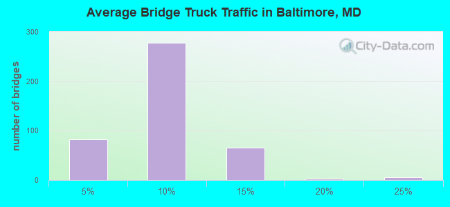
- 904,848Total average daily truck traffic
- National Bridge Inventory (NBI) Registered Bridges for Baltimore
- No street view available for this location
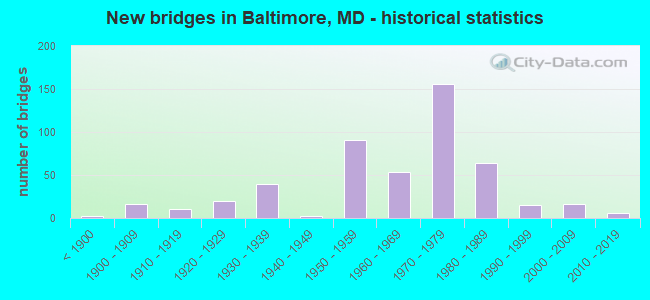
- New bridges - historical statistics
- 2Before 1900
- 161900-1909
- 111910-1919
- 201920-1929
- 391930-1939
- 21940-1949
- 911950-1959
- 541960-1969
- 1561970-1979
- 641980-1989
- 151990-1999
- 162000-2009
- 62010-2019
- 12020-2022
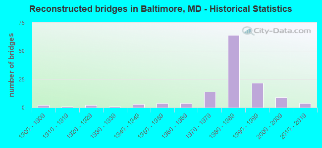
- Reconstructed bridges - Historical Statistics
- 21900-1909
- 11910-1919
- 21920-1929
- 11930-1939
- 31940-1949
- 41950-1959
- 41960-1969
- 141970-1979
- 641980-1989
- 221990-1999
- 92000-2009
- 42010-2019

- Bridge Condition - Deck
- 2.1%Very good
- 48.6%Good
- 34.5%Satisfactory
- 11.1%Fair
- 3.0%Poor
- 0.6%Serious
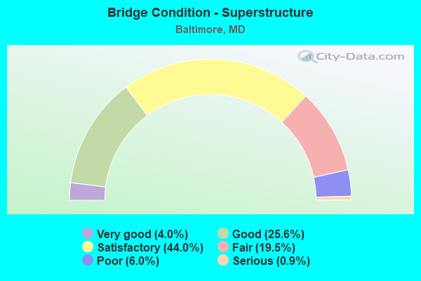
- Bridge Condition - Superstructure
- 4.0%Very good
- 25.6%Good
- 44.0%Satisfactory
- 19.5%Fair
- 6.0%Poor
- 0.9%Serious
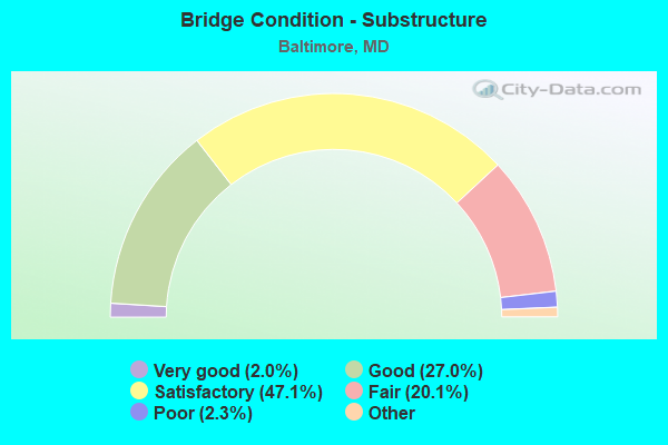
- Bridge Condition - Substructure
- 2.0%Very good
- 27.0%Good
- 47.1%Satisfactory
- 20.1%Fair
- 2.3%Poor
- 1.4%Serious
- 0.9%Critical
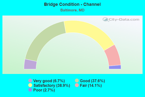
- Bridge Condition - Channel
- 6.7%Very good
- 37.6%Good
- 38.9%Satisfactory
- 14.1%Fair
- 2.7%Poor
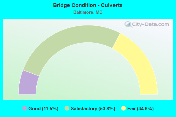
- Bridge Condition - Culverts
- 11.5%Good
- 53.8%Satisfactory
- 34.6%Fair
Find on map >> Show street view
Structure Number: 200000BC421401, Location: MORAVIA RAMP TO PULASKI H (Lat: 39.507683, Lng: -76.886986), Route carried "on" structure: Ramp City street 55, Year Built: 1970, Year Reconstructed: 1993, Status: Open, Structure Length: 6.28m (20.60ft), Average Daily Traffic: 8,480 (year 2015), Truck Traffic: 16%, Average Future Daily Traffic: 10,350 (year 2035), Features Intersected: HERRING RUN, Facility Carried by Structure: MORAVIA ROAD RAMP
Minimum Vertical Clearance: 30+ m (98+ ft), Kilometerpoint: 0.000, Lanes on structure: 1, Owner: City or Municipal Highway Agency, Approaching Roadway Width: 7.3m (24.0ft), Skew: 1 degrees, Material/Design: Steel continuous, Design/Construction: Stringer/Multi-beam, Number Of Spans In Main Unit: 3, Length of Maximum Span: 19.5m (64.0ft), Curb-To-Curb Width: 7.3m (24.0ft), Out-to-Out Width: 8.5m (27.9ft)
Condition: Deck: Good, Superstructure: Good, Substructure: Satisfactory, Channel: Good, Operating Rating: 84.4 metric tons, Method Used To Determine Operating Rating: Load Factor (LF), Inventory Rating: 50.3 metric tons, Method Used To Determine Inventory Rating: Load Factor (LF), Structural Evaluation: Equal to present minimum criteria, Deck Geometry: Better than present minimum criteria, Waterway Adequacy: Superior to present desirable criteria, Approach Roadway Alignment: Equal to present desirable criteria, Length Of Structure Improvement: 5.82m (19.09ft), Designated Inspection Frequency: Every 24 months, Inspection Date: October 2020, Bridge Improvement Cost: $8,000, Roadway Improvement Cost: $2,000, Total Project Cost: $10,000, Deck Structure Type: Concrete Cast-file-Place
Find on map >> Show street view
Structure Number: 200000BC425502, Location: 0.6 MI SE OF BELAIR RD (Lat: 39.336722, Lng: -76.539389), Route carried "on" structure: City street 961, Year Built: 1964, Status: Open, Structure Length: 25.09m (82.32ft), Average Daily Traffic: 4,563 (year 2016), Truck Traffic: 5%, Average Future Daily Traffic: 5,820 (year 2037), Features Intersected: MOORE'S RUN, Facility Carried by Structure: HAMILTON AVENUE
Minimum Vertical Clearance: 30+ m (98+ ft), Kilometerpoint: 3.588, Lanes on structure: 2, Owner: City or Municipal Highway Agency, Approaching Roadway Width: 13.4m (44.0ft), Skew: 9 degrees, Material/Design: Concrete, Design/Construction: Culvert, Length of Maximum Span: 25.3m (83.0ft), Curb or Sidewalk Widths: Left: 1.5m (4.9ft), Right: 1.5m (4.9ft)
Condition: Channel: Fair, Culverts: Satisfactory, Operating Rating: 32.7 metric tons, Method Used To Determine Operating Rating: Field evaluation and documented engineering judgment, Inventory Rating: 32.7 metric tons, Method Used To Determine Inventory Rating: Field evaluation and documented engineering judgment, Structural Evaluation: Equal to present minimum criteria, Waterway Adequacy: Equal to present desirable criteria, Approach Roadway Alignment: Equal to present minimum criteria, Length Of Structure Improvement: 25.09m (82.32ft), Designated Inspection Frequency: Every 24 months, Inspection Date: April 2020, Bridge Improvement Cost: $32,000, Total Project Cost: $36,000 ( Estimate for 2018)
Find on map >> Show street view
Structure Number: 200000BC425602, Location: 0.2 MI N OF IS 895 (Lat: 39.313500, Lng: -76.543500), Route carried "on" structure: City street 55, Year Built: 1966, Status: Open, Structure Length: 1.19m (3.90ft), Average Daily Traffic: 25,077 (year 2016), Truck Traffic: 5%, Average Future Daily Traffic: 33,700 (year 2036), Design Load: HS 20, Features Intersected: BIDDISON RUN, Facility Carried by Structure: MORAVIA ROAD
Minimum Vertical Clearance: 30+ m (98+ ft), Kilometerpoint: 3.846, Lanes on structure: 6, Owner: City or Municipal Highway Agency, Approaching Roadway Width: 29.3m (96.1ft), Skew: 25 degrees, Material/Design: Concrete, Design/Construction: Culvert, Length of Maximum Span: 3.7m (12.1ft)
Condition: Channel: Satisfactory, Culverts: Satisfactory, Operating Rating: 32.7 metric tons, Method Used To Determine Operating Rating: Field evaluation and documented engineering judgment, Inventory Rating: 32.7 metric tons, Method Used To Determine Inventory Rating: Field evaluation and documented engineering judgment, Structural Evaluation: Equal to present minimum criteria, Waterway Adequacy: Somewhat better than minimum adequacy, Approach Roadway Alignment: Equal to present desirable criteria, Length Of Structure Improvement: 1.19m (3.90ft), Designated Inspection Frequency: Every 24 months, Inspection Date: December 2020, Bridge Improvement Cost: $13,000, Roadway Improvement Cost: $9,000, Total Project Cost: $22,000
Find on map >> Show street view
Structure Number: 200000BC425702, Location: PULASKI HY OV MOORE'S RUN (Lat: 39.309633, Lng: -76.530839), Route carried "on" structure: US 40, Year Built: 1971, Status: Open, Structure Length: 1.62m (5.31ft), Average Daily Traffic: 45,410 (year 2007), Truck Traffic: 8%, Average Future Daily Traffic: 55,960 (year 2027), Design Load: H 20, Features Intersected: MOORES RUN, Facility Carried by Structure: PULASKI HIGHWAY
Minimum Vertical Clearance: 30+ m (98+ ft), Kilometerpoint: 3.846, Lanes on structure: 7, Owner: City or Municipal Highway Agency, Approaching Roadway Width: 28.3m (92.8ft), Skew: 22 degrees, Material/Design: Concrete, Design/Construction: Culvert, Number Of Spans In Main Unit: 3, Length of Maximum Span: 0.0m, Curb or Sidewalk Widths: Left: 1.5m (4.9ft), Right: 0.0m
Condition: Channel: Poor, Culverts: Good, Operating Rating: 32.7 metric tons, Method Used To Determine Operating Rating: Field evaluation and documented engineering judgment, Inventory Rating: 32.7 metric tons, Method Used To Determine Inventory Rating: Field evaluation and documented engineering judgment, Structural Evaluation: Better than present minimum criteria, Waterway Adequacy: Equal to present minimum criteria, Approach Roadway Alignment: Equal to present desirable criteria, Length Of Structure Improvement: 1.80m (5.91ft), Designated Inspection Frequency: Every 24 months, Inspection Date: November 2020, Bridge Improvement Cost: $1,000, Roadway Improvement Cost: $1,000, Total Project Cost: $2,000
Find on map >> Show street view
Structure Number: 200000BC430101, Location: KEITH AVE OV BROENING HWY (Lat: 39.449861, Lng: -76.908664), Route carried "on" structure: City street 5854, Year Built: 1973, Status: Open, Structure Length: 5.97m (19.59ft), Average Daily Traffic: 1,849 (year 2016), Truck Traffic: 5%, Average Future Daily Traffic: 2,301 (year 2028), Design Load: HS 20, Features Intersected: BROENING HIGHWAY, Facility Carried by Structure: KEITH AVENUE
Minimum Vertical Clearance: 30+ m (98+ ft), Kilometerpoint: 1.207, Lanes on structure: 2, Lanes under structure: 5, Owner: City or Municipal Highway Agency, Approaching Roadway Width: 9.1m (29.9ft), Skew: 1 degrees, Material/Design: Steel, Design/Construction: Stringer/Multi-beam, Number Of Spans In Main Unit: 3, Length of Maximum Span: 23.8m (78.1ft), Curb-To-Curb Width: 9.2m (30.2ft), Out-to-Out Width: 10.2m (33.5ft)
Condition: Deck: Satisfactory, Superstructure: Fair, Substructure: Fair, Operating Rating: 85.7 metric tons, Method Used To Determine Operating Rating: Load Factor (LF), Inventory Rating: 51.2 metric tons, Method Used To Determine Inventory Rating: Load Factor (LF), Structural Evaluation: Somewhat better than minimum adequacy, Deck Geometry: Meets minimum limits, Underclear: High priority of corrective action, Approach Roadway Alignment: Equal to present desirable criteria, Length Of Structure Improvement: 5.97m (19.59ft), Designated Inspection Frequency: Every 24 months, Inspection Date: October 2020, Bridge Improvement Cost: $82,000, Roadway Improvement Cost: $20,000, Total Project Cost: $102,000, Deck Structure Type: Concrete Cast-file-Place
Find on map >> Show street view
Structure Number: 200000BC440101, Location: 0.2 MI W OF I-895 (Lat: 39.291683, Lng: -76.558125), Route carried "on" structure: City street 150, Year Built: 1991, Status: Open, Structure Length: 12.62m (41.40ft), Average Daily Traffic: 30,700 (year 2007), Truck Traffic: 5%, Average Future Daily Traffic: 38,200 (year 2027), Design Load: HS 20, Features Intersected: NORFOLK SOUTHERN RAILROA, Facility Carried by Structure: LOMBARD STREET VIA
Minimum Vertical Clearance: 30+ m (98+ ft), Kilometerpoint: 1.319, Lanes on structure: 4, Owner: City or Municipal Highway Agency, Approaching Roadway Width: 13.4m (44.0ft), Skew: 2 degrees, Material/Design: Steel continuous, Design/Construction: Stringer/Multi-beam, Number Of Spans In Main Unit: 5, Length of Maximum Span: 28.3m (92.8ft), Curb or Sidewalk Widths: Left: 0.0m, Right: 1.5m (4.9ft), Curb-To-Curb Width: 13.4m (44.0ft), Out-to-Out Width: 19.1m (62.7ft)
Condition: Deck: Good, Superstructure: Satisfactory, Substructure: Good, Operating Rating: 59.4 metric tons, Method Used To Determine Operating Rating: Load Factor (LF), Inventory Rating: 35.4 metric tons, Method Used To Determine Inventory Rating: Load Factor (LF), Structural Evaluation: Equal to present minimum criteria, Deck Geometry: High priority of replacement, Underclear: High priority of corrective action, Approach Roadway Alignment: Equal to present minimum criteria, Length Of Structure Improvement: 12.62m (41.40ft), Designated Inspection Frequency: Every 24 months, Inspection Date: November 2020, Bridge Improvement Cost: $111,000, Roadway Improvement Cost: $22,000, Total Project Cost: $133,000, Deck Structure Type: Concrete Cast-file-Place, Wearing Surface/Protective System: Wearing Surface: Monolithic Concrete, Deck Protection: Epoxy Coated Reinforcing
Find on map >> Show street view
Structure Number: 200000BC440201, Location: 0.6 MI W ERDMAN AVE (Lat: 39.326400, Lng: -76.567556), Route carried "on" structure: US 1, Year Built: 1925, Status: Open, Structure Length: 1.59m (5.22ft), Average Daily Traffic: 22,752 (year 2020), Truck Traffic: 8%, Average Future Daily Traffic: 27,761 (year 2040), Design Load: H 20, Features Intersected: HERRING RUN, Facility Carried by Structure: BELAIR ROAD
Minimum Vertical Clearance: 30+ m (98+ ft), Kilometerpoint: 1.319, Lanes on structure: 4, Owner: City or Municipal Highway Agency, Approaching Roadway Width: 19.2m (63.0ft), Material/Design: Concrete, Design/Construction: Arch - Deck, Number Of Spans In Main Unit: 1, Length of Maximum Span: 15.9m (52.2ft), Curb or Sidewalk Widths: Left: 1.8m (5.9ft), Right: 1.8m (5.9ft), Curb-To-Curb Width: 19.3m (63.3ft), Out-to-Out Width: 23.9m (78.4ft)
Condition: Superstructure: Fair, Substructure: Fair, Channel: Fair, Operating Rating: 32.7 metric tons, Method Used To Determine Operating Rating: Field evaluation and documented engineering judgment, Inventory Rating: 32.7 metric tons, Method Used To Determine Inventory Rating: Field evaluation and documented engineering judgment, Structural Evaluation: Somewhat better than minimum adequacy, Deck Geometry: Equal to present minimum criteria, Waterway Adequacy: Equal to present desirable criteria, Approach Roadway Alignment: Equal to present desirable criteria, Length Of Structure Improvement: 1.74m (5.71ft), Designated Inspection Frequency: Every 24 months, Underwater Inspection Frequency: Every 60 months, Inspection Date: August 2020, Underwater Inspection Date: November 2017, Bridge Improvement Cost: $28,000, Roadway Improvement Cost: $23,000, Total Project Cost: $51,000, Wearing Surface/Protective System: Wearing Surface: Bituminous
Find on map >> Show street view
Structure Number: 200000BC440301, Location: 0.5 MI W OF I-895 (Lat: 39.280606, Lng: -76.562767), Route carried "on" structure: City street 1400, Year Built: 1999, Status: Open, Structure Length: 31.58m (103.61ft), Average Daily Traffic: 25,970 (year 2007), Truck Traffic: 10%, Average Future Daily Traffic: 31,860 (year 2027), Design Load: HS 25 or greater, Features Intersected: NORFOLK SOUTHERN RR, CAN, Facility Carried by Structure: O'DONNELL STREET
Minimum Vertical Clearance: 30+ m (98+ ft), Kilometerpoint: 1.191, Lanes on structure: 4, Lanes under structure: 2, Base Highway Network: Yes, Owner: City or Municipal Highway Agency, Approaching Roadway Width: 16.8m (55.1ft), Skew: 30 degrees, Material/Design: Steel continuous, Design/Construction: Stringer/Multi-beam, Number Of Spans In Main Unit: 8, Length of Maximum Span: 45.7m (149.9ft), Curb or Sidewalk Widths: Left: 1.6m (5.2ft), Right: 0.0m, Curb-To-Curb Width: 16.7m (54.8ft), Out-to-Out Width: 19.6m (64.3ft)
Condition: Deck: Good, Superstructure: Good, Substructure: Good, Operating Rating: 42.2 metric tons, Method Used To Determine Operating Rating: Load Factor (LF), Inventory Rating: 25.4 metric tons, Method Used To Determine Inventory Rating: Load Factor (LF), Structural Evaluation: Equal to present minimum criteria, Deck Geometry: Somewhat better than minimum adequacy, Underclear: Meets minimum limits, Approach Roadway Alignment: Equal to present minimum criteria, Designated Inspection Frequency: Every 24 months, Inspection Date: October 2020, Deck Structure Type: Concrete Cast-file-Place
Find on map >> Show street view
Structure Number: 200000BC440401, Location: PONCA ST. OVER CANTON RR (Lat: 39.282236, Lng: -76.554736), Route carried "on" structure: City street 1300, Year Built: 1973, Status: Open, Structure Length: 3.66m (12.01ft), Average Daily Traffic: 2,287 (year 2020), Truck Traffic: 5%, Average Future Daily Traffic: 2,847 (year 2042), Design Load: HS 20, Features Intersected: CANTON RAILROAD, Facility Carried by Structure: PONCA STREET
Minimum Vertical Clearance: 7.62m (25.00ft), Kilometerpoint: 1.078, Lanes on structure: 2, Owner: City or Municipal Highway Agency, Approaching Roadway Width: 11.0m (36.1ft), Skew: 4 degrees, Material/Design: Steel continuous, Design/Construction: Frame, Number Of Spans In Main Unit: 3, Length of Maximum Span: 17.1m (56.1ft), Curb or Sidewalk Widths: Left: 1.8m (5.9ft), Right: 1.8m (5.9ft), Curb-To-Curb Width: 11.0m (36.1ft), Out-to-Out Width: 15.2m (49.9ft)
Condition: Deck: Poor, Superstructure: Satisfactory, Substructure: Satisfactory, Inventory Rating: 57.1 metric tons, Method Used To Determine Inventory Rating: Load Factor (LF), Structural Evaluation: Equal to present minimum criteria, Deck Geometry: Somewhat better than minimum adequacy, Underclear: Meets minimum limits, Approach Roadway Alignment: Equal to present minimum criteria, Length Of Structure Improvement: 3.66m (12.01ft), Designated Inspection Frequency: Every 24 months, Inspection Date: October 2020, Bridge Improvement Cost: $125,000, Roadway Improvement Cost: $3,000, Total Project Cost: $128,000 ( Estimate for 2016), Deck Structure Type: Concrete Cast-file-Place
Find on map >> Show street view
Structure Number: 200000BC440501, Location: 0.2 MI W CEDONIA AVE (Lat: 39.330244, Lng: -76.535039), Route carried "on" structure: City street 1030, Year Built: 1930, Year Reconstructed: 1960, Status: Open, Structure Length: 1.10m (3.61ft), Average Daily Traffic: 10,737 (year 2016), Truck Traffic: 5%, Average Future Daily Traffic: 13,102 (year 2036), Features Intersected: MOORE'S RUN, Facility Carried by Structure: RADECKE AVENUE
Minimum Vertical Clearance: 30+ m (98+ ft), Kilometerpoint: 0.579, Lanes on structure: 2, Owner: City or Municipal Highway Agency, Approaching Roadway Width: 12.2m (40.0ft), Material/Design: Steel, Design/Construction: Stringer/Multi-beam, Number Of Spans In Main Unit: 1, Length of Maximum Span: 9.8m (32.2ft), Curb or Sidewalk Widths: Left: 1.3m (4.3ft), Right: 1.3m (4.3ft), Curb-To-Curb Width: 12.3m (40.4ft), Out-to-Out Width: 15.4m (50.5ft)
Condition: Deck: Satisfactory, Superstructure: Poor, Substructure: Poor, Channel: Satisfactory, Operating Rating: 32.7 metric tons, Method Used To Determine Operating Rating: Field evaluation and documented engineering judgment, Inventory Rating: 32.7 metric tons, Method Used To Determine Inventory Rating: Field evaluation and documented engineering judgment, Structural Evaluation: Meets minimum limits, Deck Geometry: Somewhat better than minimum adequacy, Waterway Adequacy: Equal to present desirable criteria, Approach Roadway Alignment: Equal to present desirable criteria, Length Of Structure Improvement: 1.10m (3.61ft), Designated Inspection Frequency: Every 12 months, Inspection Date: August 2021, Bridge Improvement Cost: $126,000, Roadway Improvement Cost: $12,000, Total Project Cost: $138,000, Deck Structure Type: Concrete Cast-file-Place, Wearing Surface/Protective System: Wearing Surface: Bituminous
Find on map >> Show street view
Structure Number: 200000BC450101, Location: 0.8 MI W ERDMAN AVE (Lat: 39.323439, Lng: -76.561478), Route carried "on" structure: City street 2525, Year Built: 1963, Status: Open, Structure Length: 2.80m (9.19ft), Average Daily Traffic: 32,043 (year 2020), Truck Traffic: 5%, Average Future Daily Traffic: 39,078 (year 2040), Design Load: HS 20, Features Intersected: HERRING RUN, Facility Carried by Structure: BREHMS LANE
Minimum Vertical Clearance: 30+ m (98+ ft), Kilometerpoint: 0.290, Lanes on structure: 2, Owner: City or Municipal Highway Agency, Approaching Roadway Width: 9.1m (29.9ft), Material/Design: Steel, Design/Construction: Stringer/Multi-beam, Number Of Spans In Main Unit: 1, Length of Maximum Span: 26.8m (87.9ft), Curb or Sidewalk Widths: Left: 1.5m (4.9ft), Right: 1.5m (4.9ft), Curb-To-Curb Width: 9.2m (30.2ft), Out-to-Out Width: 12.9m (42.3ft)
Condition: Deck: Fair, Superstructure: Fair, Substructure: Poor, Channel: Satisfactory, Operating Rating: 82.5 metric tons, Method Used To Determine Operating Rating: Load Factor (LF), Inventory Rating: 49.4 metric tons, Method Used To Determine Inventory Rating: Load Factor (LF), Structural Evaluation: Meets minimum limits, Deck Geometry: High priority of corrective action, Waterway Adequacy: Equal to present desirable criteria, Approach Roadway Alignment: Equal to present minimum criteria, Length Of Structure Improvement: 2.80m (9.19ft), Designated Inspection Frequency: Every 24 months, Inspection Date: December 2020, Bridge Improvement Cost: $156,000, Roadway Improvement Cost: $19,000, Total Project Cost: $175,000, Deck Structure Type: Concrete Cast-file-Place, Wearing Surface/Protective System: Wearing Surface: Bituminous
Find on map >> Show street view
Structure Number: 200000BC450201, Location: 0.6 MI W ERDMAN AVE (Lat: 39.324661, Lng: -76.562656), Route carried "on" structure: City street 2485, Year Built: 1928, Status: Open, Structure Length: 1.71m (5.61ft), Average Daily Traffic: 2,933 (year 2020), Truck Traffic: 5%, Average Future Daily Traffic: 3,940 (year 2040), Design Load: H 20, Features Intersected: HERRING RUN, Facility Carried by Structure: MANNASOTA AVENUE
Minimum Vertical Clearance: 30+ m (98+ ft), Kilometerpoint: 0.917, Lanes on structure: 2, Owner: City or Municipal Highway Agency, Approaching Roadway Width: 9.1m (29.9ft), Material/Design: Concrete, Design/Construction: Arch - Deck, Number Of Spans In Main Unit: 1, Length of Maximum Span: 15.9m (52.2ft), Curb or Sidewalk Widths: Left: 2.4m (7.9ft), Right: 2.0m (6.6ft), Curb-To-Curb Width: 9.2m (30.2ft), Out-to-Out Width: 14.8m (48.6ft)
Condition: Superstructure: Satisfactory, Substructure: Satisfactory, Channel: Fair, Operating Rating: 83.4 metric tons, Method Used To Determine Operating Rating: Load Factor (LF), Inventory Rating: 49.9 metric tons, Method Used To Determine Inventory Rating: Load Factor (LF), Structural Evaluation: Equal to present minimum criteria, Deck Geometry: Meets minimum limits, Waterway Adequacy: Superior to present desirable criteria, Approach Roadway Alignment: Equal to present desirable criteria, Length Of Structure Improvement: 1.71m (5.61ft), Designated Inspection Frequency: Every 24 months, Inspection Date: October 2020, Bridge Improvement Cost: $31,000, Roadway Improvement Cost: $17,000, Total Project Cost: $48,000, Wearing Surface/Protective System: Wearing Surface: Bituminous
Find on map >> Show street view
Structure Number: 200000BC455602, Location: 0.3 MI NE OF IS 895 (Lat: 39.316161, Lng: -76.543856), Route carried "on" structure: City street 1020, Year Built: 1966, Status: Open, Structure Length: 0.76m (2.49ft), Average Daily Traffic: 1,374 (year 2016), Truck Traffic: 5%, Average Future Daily Traffic: 1,894 (year 2036), Design Load: HS 20, Features Intersected: BIDDISON RUN, Facility Carried by Structure: MORAVIA PARK DRIVE
Minimum Vertical Clearance: 30+ m (98+ ft), Kilometerpoint: 0.257, Lanes on structure: 2, Owner: City or Municipal Highway Agency, Approaching Roadway Width: 13.4m (44.0ft), Material/Design: Concrete, Design/Construction: Culvert, Number Of Spans In Main Unit: 2, Length of Maximum Span: 3.7m (12.1ft), Curb or Sidewalk Widths: Left: 1.2m (3.9ft), Right: 1.2m (3.9ft), Out-to-Out Width: 33.5m (109.9ft)
Condition: Channel: Fair, Culverts: Satisfactory, Operating Rating: 32.7 metric tons, Method Used To Determine Operating Rating: Field evaluation and documented engineering judgment, Inventory Rating: 32.7 metric tons, Method Used To Determine Inventory Rating: Field evaluation and documented engineering judgment, Structural Evaluation: Equal to present minimum criteria, Waterway Adequacy: Equal to present minimum criteria, Approach Roadway Alignment: Equal to present minimum criteria, Length Of Structure Improvement: 0.76m (2.49ft), Designated Inspection Frequency: Every 24 months, Inspection Date: October 2020, Bridge Improvement Cost: $16,000, Roadway Improvement Cost: $4,000, Total Project Cost: $20,000, Deck Structure Type: Concrete Cast-file-Place, Wearing Surface/Protective System: Wearing Surface: Bituminous
Find on map >> Show street view
Structure Number: 200000BC510101, Location: RUSSELL ST VIA OV OSTEND (Lat: 39.274611, Lng: -77.052742), Route carried "on" structure: State highway 295, Year Built: 1951, Year Reconstructed: 1981, Status: Open, Structure Length: 38.68m (126.90ft), Average Daily Traffic: 70,700 (year 2019), Truck Traffic: 8%, Average Future Daily Traffic: 86,100 (year 2039), Design Load: HS 20, Features Intersected: OSTEND STREET AND CSX, Facility Carried by Structure: RUSSELL STREET VIA
Minimum Vertical Clearance: 30+ m (98+ ft), Kilometerpoint: 0.322, Lanes on structure: 6, Lanes under structure: 6, Base Highway Network: Yes, Owner: City or Municipal Highway Agency, Approaching Roadway Width: 25.6m (84.0ft), Skew: 20 degrees, Material/Design: Steel, Design/Construction: Stringer/Multi-beam, Number Of Spans In Main Unit: 19, Length of Maximum Span: 24.7m (81.0ft), Curb-To-Curb Width: 26.2m (86.0ft), Out-to-Out Width: 27.1m (88.9ft)
Condition: Deck: Satisfactory, Superstructure: Fair, Substructure: Poor, Operating Rating: 60.3 metric tons, Method Used To Determine Operating Rating: Allowable Stress (AS), Inventory Rating: 35.8 metric tons, Method Used To Determine Inventory Rating: Allowable Stress (AS), Structural Evaluation: Meets minimum limits, Deck Geometry: Equal to present minimum criteria, Underclear: Equal to present minimum criteria, Approach Roadway Alignment: Equal to present desirable criteria, Length Of Structure Improvement: 9.63m (31.59ft), Designated Inspection Frequency: Every 24 months, Critical Feature Inspection Frequency: Every 24 months, Inspection Date: September 2021, Critical Feature Inspection Date: September 2021, Bridge Improvement Cost: $2,975,000, Roadway Improvement Cost: $32,000, Total Project Cost: $3,007,000 ( Estimate for 2016), Deck Structure Type: Concrete Cast-file-Place, Wearing Surface/Protective System: Wearing Surface: Bituminous, Deck Protection: Epoxy Coated Reinforcing
Find on map >> Show street view
Structure Number: 200000BC510201, Location: RUSSELL ST VIA OV MONROE (Lat: 39.270847, Lng: -76.631633), Route carried "on" structure: State highway 295, Year Built: 2007, Status: Open, Structure Length: 31.97m (104.89ft), Average Daily Traffic: 13,000 (year 2007), Truck Traffic: 8%, Average Future Daily Traffic: 17,693 (year 2038), Design Load: HS 25 or greater, Features Intersected: MONROE STREET, Facility Carried by Structure: RUSSELL STREET
Minimum Vertical Clearance: 5.49m (18.01ft), Kilometerpoint: 0.998, Lanes on structure: 7, Lanes under structure: 4, Owner: City or Municipal Highway Agency, Approaching Roadway Width: 29.6m (97.1ft), Skew: 20 degrees, Material/Design: Steel, Design/Construction: Stringer/Multi-beam, Number Of Spans In Main Unit: 11, Number Of Approach Spans: 1, Length of Maximum Span: 38.1m (125.0ft), Curb-To-Curb Width: 29.4m (96.5ft), Out-to-Out Width: 30.8m (101.0ft)
Condition: Deck: Satisfactory, Superstructure: Good, Substructure: Good, Operating Rating: 51.7 metric tons, Method Used To Determine Operating Rating: Load Factor (LF), Inventory Rating: 30.8 metric tons, Method Used To Determine Inventory Rating: Load Factor (LF), Structural Evaluation: Better than present minimum criteria, Deck Geometry: Somewhat better than minimum adequacy, Underclear: Meets minimum limits, Approach Roadway Alignment: Equal to present desirable criteria, Length Of Structure Improvement: 31.97m (104.89ft), Designated Inspection Frequency: Every 24 months, Inspection Date: September 2021, Bridge Improvement Cost: $3,592,000, Roadway Improvement Cost: $300,000, Total Project Cost: $3,892,000, Deck Structure Type: Concrete Cast-file-Place, Wearing Surface/Protective System: Wearing Surface: Bituminous
Find on map >> Show street view
Structure Number: 200000BC510301, Location: 0.2 MI S OF I-95 (Lat: 39.267306, Lng: -76.634861), Route carried "on" structure: State highway 295, Year Built: 1963, Year Reconstructed: 1977, Status: Open, Structure Length: 6.46m (21.19ft), Average Daily Traffic: 46,276 (year 2016), Truck Traffic: 8%, Average Future Daily Traffic: 56,466 (year 2036), Design Load: HS 20, Features Intersected: CSX, Facility Carried by Structure: RUSSELL STREET
Minimum Vertical Clearance: 30+ m (98+ ft), Kilometerpoint: 0.998, Lanes on structure: 7, Base Highway Network: Yes, Owner: City or Municipal Highway Agency, Approaching Roadway Width: 29.6m (97.1ft), Skew: 22 degrees, Material/Design: Steel, Design/Construction: Stringer/Multi-beam, Number Of Spans In Main Unit: 3, Length of Maximum Span: 23.5m (77.1ft), Curb-To-Curb Width: 33.7m (110.6ft), Out-to-Out Width: 34.9m (114.5ft)
Condition: Deck: Fair, Superstructure: Poor, Substructure: Critical, Operating Rating: 73.9 metric tons, Method Used To Determine Operating Rating: Load Factor (LF), Inventory Rating: 44.4 metric tons, Method Used To Determine Inventory Rating: Load Factor (LF), Structural Evaluation: High priority of replacement, Deck Geometry: Superior to present desirable criteria, Underclear: Better than present minimum criteria, Approach Roadway Alignment: Equal to present desirable criteria, Length Of Structure Improvement: 6.46m (21.19ft), Designated Inspection Frequency: Every 24 months, Inspection Date: July 2020, Bridge Improvement Cost: $350,000, Roadway Improvement Cost: $3,000, Total Project Cost: $353,000 ( Estimate for 2016), Deck Structure Type: Concrete Cast-file-Place, Wearing Surface/Protective System: Wearing Surface: Bituminous, Deck Protection: Epoxy Coated Reinforcing
Find on map >> Show street view
Structure Number: 200000BC510405, Location: 0.3 MI S IS 95 (Lat: 39.450464, Lng: -77.065317), Route carried "on" structure: State highway 295, Year Built: 1963, Year Reconstructed: 1990, Status: Open, Structure Length: 14.69m (48.20ft), Average Daily Traffic: 51,578 (year 2007), Truck Traffic: 8%, Average Future Daily Traffic: 68,423 (year 2038), Design Load: HS 20, Features Intersected: GWYNN FALLS, MANOKIN ST,, Facility Carried by Structure: RUSSELL ST
Minimum Vertical Clearance: 30+ m (98+ ft), Kilometerpoint: 0.000, Lanes on structure: 9, Lanes under structure: 2, Base Highway Network: Yes, Owner: City or Municipal Highway Agency, Approaching Roadway Width: 36.6m (120.1ft), Skew: 20 degrees, Material/Design: Steel continuous, Design/Construction: Stringer/Multi-beam, Number Of Spans In Main Unit: 14, Length of Maximum Span: 42.7m (140.1ft), Curb-To-Curb Width: 36.7m (120.4ft), Out-to-Out Width: 38.1m (125.0ft)
Condition: Deck: Good, Superstructure: Satisfactory, Substructure: Satisfactory, Channel: Satisfactory, Operating Rating: 56.7 metric tons, Method Used To Determine Operating Rating: Load Factor (LF), Inventory Rating: 34.0 metric tons, Method Used To Determine Inventory Rating: Load Factor (LF), Structural Evaluation: Equal to present minimum criteria, Deck Geometry: Somewhat better than minimum adequacy, Underclear: Meets minimum limits, Waterway Adequacy: Superior to present desirable criteria, Approach Roadway Alignment: Equal to present desirable criteria, Length Of Structure Improvement: 14.69m (48.20ft), Designated Inspection Frequency: Every 24 months, Inspection Date: March 2020, Bridge Improvement Cost: $50,000, Roadway Improvement Cost: $1,000, Total Project Cost: $51,000, Deck Structure Type: Concrete Cast-file-Place
Find on map >> Show street view
Structure Number: 200000BC514601, Location: 0.6 M. E. OF HANOVER ST (Lat: 39.266378, Lng: -76.613175), Route carried "on" structure: City street 4320, Year Built: 1981, Status: Open, Structure Length: 3.32m (10.89ft), Average Daily Traffic: 1,979 (year 2020), Truck Traffic: 5%, Average Future Daily Traffic: 2,464 (year 2042), Design Load: HS 20, Features Intersected: CSX, Facility Carried by Structure: MCCOMAS STREET
Minimum Vertical Clearance: 30+ m (98+ ft), Kilometerpoint: 85.422, Lanes on structure: 4, Owner: City or Municipal Highway Agency, Approaching Roadway Width: 14.6m (47.9ft), Skew: 2 degrees, Material/Design: Steel, Design/Construction: Stringer/Multi-beam, Number Of Spans In Main Unit: 1, Length of Maximum Span: 32.0m (105.0ft), Curb or Sidewalk Widths: Left: 1.5m (4.9ft), Right: 0.0m, Curb-To-Curb Width: 15.9m (52.2ft), Out-to-Out Width: 18.7m (61.4ft)
Condition: Deck: Satisfactory, Superstructure: Good, Substructure: Satisfactory, Inventory Rating: 54.4 metric tons, Method Used To Determine Inventory Rating: Load Factor (LF), Structural Evaluation: Equal to present minimum criteria, Deck Geometry: Meets minimum limits, Underclear: Better than present minimum criteria, Approach Roadway Alignment: Equal to present desirable criteria, Length Of Structure Improvement: 3.20m (10.50ft), Designated Inspection Frequency: Every 24 months, Inspection Date: October 2020, Bridge Improvement Cost: $11,000, Roadway Improvement Cost: $100,000, Total Project Cost: $111,000, Deck Structure Type: Concrete Cast-file-Place, Wearing Surface/Protective System: Deck Protection: Epoxy Coated Reinforcing
Find on map >> Show street view
Structure Number: 200000BC520201, Location: 0.4 MI E CATON AVE (Lat: 0.654544, Lng: -1.277617), Route carried "on" structure: US 1, Year Built: 1936, Status: Open, Structure Length: 3.84m (12.60ft), Average Daily Traffic: 35,470 (year 2015), Truck Traffic: 8%, Average Future Daily Traffic: 43,270 (year 2035), Design Load: H 20, Features Intersected: GWYNNS FALLS, Facility Carried by Structure: WILKENS AVENUE
Minimum Vertical Clearance: 30+ m (98+ ft), Kilometerpoint: 1.706, Lanes on structure: 4, Owner: City or Municipal Highway Agency, Approaching Roadway Width: 16.5m (54.1ft), Skew: 2 degrees, Material/Design: Concrete, Design/Construction: Arch - Deck, Number Of Spans In Main Unit: 1, Length of Maximum Span: 35.1m (115.2ft), Curb or Sidewalk Widths: Left: 1.8m (5.9ft), Right: 1.8m (5.9ft), Curb-To-Curb Width: 16.5m (54.1ft), Out-to-Out Width: 21.1m (69.2ft)
Condition: Deck: Poor, Superstructure: Poor, Substructure: Fair, Channel: Satisfactory, Inventory Rating: 67.6 metric tons, Method Used To Determine Inventory Rating: Load Factor (LF), Structural Evaluation: Meets minimum limits, Deck Geometry: Meets minimum limits, Waterway Adequacy: Superior to present desirable criteria, Approach Roadway Alignment: Equal to present desirable criteria, Length Of Structure Improvement: 3.84m (12.60ft), Designated Inspection Frequency: Every 24 months, Inspection Date: December 2021, Bridge Improvement Cost: $63,000, Roadway Improvement Cost: $11,000, Total Project Cost: $74,000, Wearing Surface/Protective System: Wearing Surface: Bituminous
Find on map >> Show street view
Structure Number: 200000BC520301, Location: 0.1 MI W OF BRUNSWICK ST (Lat: 39.271100, Lng: -76.679486), Route carried "on" structure: US 1, Year Built: 1991, Status: Open, Structure Length: 1.34m (4.40ft), Average Daily Traffic: 9,264 (year 2016), Truck Traffic: 8%, Average Future Daily Traffic: 10,971 (year 2033), Design Load: HS 20, Features Intersected: CSX RAILROAD, Facility Carried by Structure: WILKENS AVE
Minimum Vertical Clearance: 30+ m (98+ ft), Kilometerpoint: 1.706, Lanes on structure: 4, Owner: City or Municipal Highway Agency, Approaching Roadway Width: 16.5m (54.1ft), Material/Design: Steel, Design/Construction: Stringer/Multi-beam, Number Of Spans In Main Unit: 1, Length of Maximum Span: 12.5m (41.0ft), Curb or Sidewalk Widths: Left: 1.6m (5.2ft), Right: 1.6m (5.2ft), Curb-To-Curb Width: 18.3m (60.0ft), Out-to-Out Width: 22.0m (72.2ft)
Condition: Deck: Good, Superstructure: Good, Substructure: Satisfactory, Inventory Rating: 61.7 metric tons, Method Used To Determine Inventory Rating: Load Factor (LF), Structural Evaluation: Equal to present minimum criteria, Deck Geometry: Somewhat better than minimum adequacy, Underclear: Somewhat better than minimum adequacy, Approach Roadway Alignment: Equal to present desirable criteria, Length Of Structure Improvement: 1.34m (4.40ft), Designated Inspection Frequency: Every 24 months, Inspection Date: April 2020, Bridge Improvement Cost: $12,000, Roadway Improvement Cost: $8,000, Total Project Cost: $20,000 ( Estimate for 2016), Deck Structure Type: Concrete Cast-file-Place, Wearing Surface/Protective System: Wearing Surface: Integral Concrete
Find on map >> Show street view
Structure Number: 200000BC520401, Location: 0.2 MI W OF RTE 648 (Lat: 39.250439, Lng: -76.642564), Route carried "on" structure: City street 100, Year Built: 1994, Status: Open, Structure Length: 5.91m (19.39ft), Average Daily Traffic: 3,800 (year 2016), Truck Traffic: 5%, Average Future Daily Traffic: 4,650 (year 2036), Design Load: HS 20, Features Intersected: MD 295, B/W PARKWAY, Facility Carried by Structure: PATAPSCO AVENUE
Minimum Vertical Clearance: 30+ m (98+ ft), Kilometerpoint: 3.089, Lanes on structure: 6, Lanes under structure: 6, Owner: City or Municipal Highway Agency, Approaching Roadway Width: 21.9m (71.9ft), Skew: 21 degrees, Material/Design: Steel continuous, Design/Construction: Stringer/Multi-beam, Number Of Spans In Main Unit: 4, Length of Maximum Span: 17.4m (57.1ft), Curb or Sidewalk Widths: Left: 1.5m (4.9ft), Right: 1.5m (4.9ft), Curb-To-Curb Width: 21.9m (71.9ft), Out-to-Out Width: 30.5m (100.1ft)
Condition: Deck: Good, Superstructure: Good, Substructure: Good, Inventory Rating: 69.4 metric tons, Method Used To Determine Inventory Rating: Load Factor (LF), Structural Evaluation: Better than present minimum criteria, Deck Geometry: High priority of corrective action, Underclear: Somewhat better than minimum adequacy, Approach Roadway Alignment: Equal to present desirable criteria, Length Of Structure Improvement: 8.63m (28.31ft), Designated Inspection Frequency: Every 24 months, Inspection Date: June 2020, Bridge Improvement Cost: $23,000, Roadway Improvement Cost: $4,000, Total Project Cost: $27,000, Deck Structure Type: Concrete Cast-file-Place, Wearing Surface/Protective System: Wearing Surface: Bituminous
Find on map >> Show street view
Structure Number: 200000BC520501, Location: 1 MI E OF IS 95 (Lat: 39.255669, Lng: -76.659169), Route carried "on" structure: City street 100, Year Built: 1962, Year Reconstructed: 1990, Status: Open, Structure Length: 5.34m (17.52ft), Average Daily Traffic: 12,100 (year 2007), Truck Traffic: 5%, Average Future Daily Traffic: 14,770 (year 2027), Design Load: HS 20, Features Intersected: CSX, Facility Carried by Structure: PATAPSCO AVENUE
Minimum Vertical Clearance: 30+ m (98+ ft), Kilometerpoint: 4.714, Lanes on structure: 6, Base Highway Network: Yes, Owner: City or Municipal Highway Agency, Approaching Roadway Width: 26.8m (87.9ft), Skew: 22 degrees, Material/Design: Steel, Design/Construction: Stringer/Multi-beam, Number Of Spans In Main Unit: 3, Length of Maximum Span: 28.0m (91.9ft), Curb or Sidewalk Widths: Left: 1.5m (4.9ft), Right: 1.5m (4.9ft), Curb-To-Curb Width: 26.8m (87.9ft), Out-to-Out Width: 30.5m (100.1ft)
Condition: Deck: Good, Superstructure: Fair, Substructure: Fair, Inventory Rating: 76.6 metric tons, Method Used To Determine Inventory Rating: Load Factor (LF), Structural Evaluation: Somewhat better than minimum adequacy, Deck Geometry: Better than present minimum criteria, Underclear: High priority of corrective action, Approach Roadway Alignment: Equal to present desirable criteria, Length Of Structure Improvement: 5.33m (17.49ft), Designated Inspection Frequency: Every 24 months, Inspection Date: April 2020, Bridge Improvement Cost: $67,000, Roadway Improvement Cost: $8,000, Total Project Cost: $75,000, Deck Structure Type: Concrete Cast-file-Place, Wearing Surface/Protective System: Wearing Surface: Monolithic Concrete, Deck Protection: Epoxy Coated Reinforcing
Find on map >> Show street view
Structure Number: 200000BC5206013, Location: 2 MI E BAL WASH EXPR (Lat: 39.239844, Lng: -76.613761), Route carried "on" structure: City street 100, Year Built: 1961, Year Reconstructed: 1996, Status: Open, Structure Length: 50.41m (165.39ft), Average Daily Traffic: 23,835 (year 2007), Truck Traffic: 5%, Average Future Daily Traffic: 29,080 (year 2027), Design Load: HS 20, Features Intersected: PATAPSCO RIVER, Facility Carried by Structure: PATAPSCO AVENUE EB
Minimum Vertical Clearance: 30+ m (98+ ft), Kilometerpoint: 0.386, Lanes on structure: 3, Owner: City or Municipal Highway Agency, Approaching Roadway Width: 11.0m (36.1ft), Material/Design: Steel, Design/Construction: Stringer/Multi-beam, Number Of Spans In Main Unit: 33, Length of Maximum Span: 15.2m (49.9ft), Curb or Sidewalk Widths: Left: 0.0m, Right: 1.5m (4.9ft), Curb-To-Curb Width: 11.0m (36.1ft), Out-to-Out Width: 13.6m (44.6ft)
Condition: Deck: Fair, Superstructure: Poor, Substructure: Fair, Channel: Good, Operating Rating: 67.6 metric tons, Method Used To Determine Operating Rating: Load Factor (LF), Inventory Rating: 40.4 metric tons, Method Used To Determine Inventory Rating: Load Factor (LF), Structural Evaluation: Meets minimum limits, Deck Geometry: High priority of replacement, Waterway Adequacy: Equal to present desirable criteria, Approach Roadway Alignment: Equal to present desirable criteria, Length Of Structure Improvement: 50.41m (165.39ft), Designated Inspection Frequency: Every 24 months, Underwater Inspection Frequency: Every 60 months, Inspection Date: April 2020, Underwater Inspection Date: April 2018, Bridge Improvement Cost: $386,000, Roadway Improvement Cost: $7,000, Total Project Cost: $393,000, Deck Structure Type: Concrete Cast-file-Place, Wearing Surface/Protective System: Wearing Surface: Monolithic Concrete
Find on map >> Show street view
Structure Number: 200000BC5206014, Location: 2 MI E BAL WASH EXPR (Lat: 39.239689, Lng: -76.613836), Route carried "on" structure: City street 100, Year Built: 1961, Status: Open, Structure Length: 50.41m (165.39ft), Average Daily Traffic: 44,115 (year 2007), Truck Traffic: 5%, Average Future Daily Traffic: 53,360 (year 2027), Design Load: HS 20, Features Intersected: PATAPSCO RIVER, Facility Carried by Structure: PATAPSCO AVENUE WB
Minimum Vertical Clearance: 30+ m (98+ ft), Kilometerpoint: 0.386, Lanes on structure: 3, Owner: City or Municipal Highway Agency, Approaching Roadway Width: 11.0m (36.1ft), Material/Design: Steel, Design/Construction: Stringer/Multi-beam, Number Of Spans In Main Unit: 33, Length of Maximum Span: 15.2m (49.9ft), Curb or Sidewalk Widths: Left: 1.5m (4.9ft), Right: 0.0m, Curb-To-Curb Width: 11.0m (36.1ft), Out-to-Out Width: 13.6m (44.6ft)
Condition: Deck: Poor, Superstructure: Poor, Substructure: Fair, Channel: Good, Operating Rating: 54.9 metric tons, Method Used To Determine Operating Rating: Load Factor (LF), Inventory Rating: 33.1 metric tons, Method Used To Determine Inventory Rating: Load Factor (LF), Structural Evaluation: Meets minimum limits, Deck Geometry: High priority of replacement, Waterway Adequacy: Equal to present desirable criteria, Approach Roadway Alignment: Equal to present desirable criteria, Length Of Structure Improvement: 50.41m (165.39ft), Designated Inspection Frequency: Every 24 months, Underwater Inspection Frequency: Every 60 months, Inspection Date: April 2020, Underwater Inspection Date: April 2018, Bridge Improvement Cost: $420,000, Roadway Improvement Cost: $13,000, Total Project Cost: $433,000, Deck Structure Type: Concrete Cast-file-Place
Find on map >> Show street view
Structure Number: 200000BC520701, Location: .1 MI S OF 695 (Lat: 39.205558, Lng: -76.570217), Route carried "on" structure: State highway 173, Year Built: 1930, Status: Open, Structure Length: 3.02m (9.91ft), Average Daily Traffic: 15,177 (year 2020), Truck Traffic: 8%, Average Future Daily Traffic: 24,867 (year 2040), Design Load: H 20, Features Intersected: CSX, Facility Carried by Structure: HAWKINS POINT ROAD
Minimum Vertical Clearance: 30+ m (98+ ft), Kilometerpoint: 0.386, Lanes on structure: 4, Owner: City or Municipal Highway Agency, Approaching Roadway Width: 12.2m (40.0ft), Material/Design: Steel, Design/Construction: Stringer/Multi-beam, Number Of Spans In Main Unit: 3, Length of Maximum Span: 10.1m (33.1ft), Curb or Sidewalk Widths: Left: 1.9m (6.2ft), Right: 1.8m (5.9ft), Curb-To-Curb Width: 12.2m (40.0ft), Out-to-Out Width: 16.3m (53.5ft)
Condition: Deck: Poor, Superstructure: Poor, Substructure: Fair, Operating Rating: 75.3 metric tons, Method Used To Determine Operating Rating: Load Factor (LF), Inventory Rating: 44.9 metric tons, Method Used To Determine Inventory Rating: Load Factor (LF), Structural Evaluation: Meets minimum limits, Deck Geometry: High priority of replacement, Underclear: Meets minimum limits, Approach Roadway Alignment: Equal to present minimum criteria, Length Of Structure Improvement: 3.05m (10.01ft), Designated Inspection Frequency: Every 24 months, Inspection Date: September 2020, Bridge Improvement Cost: $114,000, Roadway Improvement Cost: $217,000, Total Project Cost: $331,000 ( Estimate for 2016), Deck Structure Type: Concrete Cast-file-Place, Wearing Surface/Protective System: Wearing Surface: Bituminous
Find on map >> Show street view
Structure Number: 200000BC520901, Location: HANOVER ST OVER CSX RR (Lat: 39.266889, Lng: -76.614778), Route carried "on" structure: State highway 2, Year Built: 1929, Status: Open, Structure Length: 6.28m (20.60ft), Average Daily Traffic: 2,745 (year 2020), Truck Traffic: 8%, Average Future Daily Traffic: 34,860 (year 2042), Design Load: H 20, Features Intersected: CSX, Facility Carried by Structure: HANOVER STREET
Minimum Vertical Clearance: 30+ m (98+ ft), Kilometerpoint: 0.386, Lanes on structure: 4, Base Highway Network: Yes, Owner: City or Municipal Highway Agency, Approaching Roadway Width: 15.2m (49.9ft), Material/Design: Steel, Design/Construction: Stringer/Multi-beam, Number Of Spans In Main Unit: 3, Length of Maximum Span: 21.0m (68.9ft), Curb or Sidewalk Widths: Left: 2.5m (8.2ft), Right: 2.5m (8.2ft), Curb-To-Curb Width: 15.2m (49.9ft), Out-to-Out Width: 21.2m (69.6ft)
Condition: Deck: Serious, Superstructure: Fair, Substructure: Fair, Operating Rating: 32.7 metric tons, Method Used To Determine Operating Rating: Field evaluation and documented engineering judgment, Inventory Rating: 32.7 metric tons, Method Used To Determine Inventory Rating: Field evaluation and documented engineering judgment, Structural Evaluation: Somewhat better than minimum adequacy, Deck Geometry: High priority of corrective action, Underclear: Somewhat better than minimum adequacy, Approach Roadway Alignment: Equal to present desirable criteria, Length Of Structure Improvement: 6.28m (20.60ft), Designated Inspection Frequency: Every 24 months, Inspection Date: October 2020, Bridge Improvement Cost: $128,000, Roadway Improvement Cost: $11,000, Total Project Cost: $139,000, Deck Structure Type: Concrete Cast-file-Place, Wearing Surface/Protective System: Wearing Surface: Monolithic Concrete
Find on map >> Show street view
Structure Number: 200000BC521001, Location: 0.5 MI S OF I 95 (Lat: 39.260961, Lng: -76.615106), Route carried "on" structure: State highway 2, Year Built: 1916, Year Reconstructed: 1992, Status: Open, Structure Length: 61.66m (202.30ft), Average Daily Traffic: 14,220 (year 2016), Truck Traffic: 8%, Average Future Daily Traffic: 17,520 (year 2036), Design Load: HS 20, Features Intersected: MIDDLE BRANCH, Facility Carried by Structure: HANOVER STREET
Minimum Vertical Clearance: 30+ m (98+ ft), Kilometerpoint: 0.386, Lanes on structure: 5, Base Highway Network: Yes, Owner: City or Municipal Highway Agency, Approaching Roadway Width: 18.3m (60.0ft), Navigation Control: Yes ( Vertical Clearance: 11.3m (37.1ft), Horizontal Clearance: 45.7m (149.9ft)), Material/Design: Steel, Design/Construction: Movable - Bascule, Number Of Spans In Main Unit: 1, Number Of Approach Spans: 36, Length of Maximum Span: 69.8m (229.0ft), Curb or Sidewalk Widths: Left: 1.5m (4.9ft), Right: 1.5m (4.9ft), Curb-To-Curb Width: 18.3m (60.0ft), Out-to-Out Width: 21.9m (71.9ft)
Condition: Deck: Fair, Superstructure: Poor, Substructure: Fair, Channel: Good, Operating Rating: 42.6 metric tons, Method Used To Determine Operating Rating: Load Factor (LF), Inventory Rating: 25.4 metric tons, Method Used To Determine Inventory Rating: Load Factor (LF), Structural Evaluation: Meets minimum limits, Deck Geometry: High priority of replacement, Waterway Adequacy: Equal to present desirable criteria, Approach Roadway Alignment: Equal to present desirable criteria, Length Of Structure Improvement: 69.80m (229.00ft), Designated Inspection Frequency: Every 12 months, Critical Feature Inspection Frequency: Every 12 months, Underwater Inspection Frequency: Every 48 months, Other Special Inspection Frequency: Every 24 months, Inspection Date: November 2021, Critical Feature Inspection Date: November 2021, Underwater Inspection Date: November 2018, Other Special Inspection Date: January 2021, Bridge Improvement Cost: $705,000, Roadway Improvement Cost: $64,000, Total Project Cost: $769,000, Deck Structure Type: Concrete Cast-file-Place, Wearing Surface/Protective System: Wearing Surface: Monolithic Concrete, Deck Protection: Other Coated Reinforcing
Find on map >> Show street view
Structure Number: 200000BC521101, Location: 1.3 MI S OF IS 95 (Lat: 39.246406, Lng: -76.610981), Route carried "on" structure: State highway 2, Year Built: 1973, Status: Open, Structure Length: 20.30m (66.60ft), Average Daily Traffic: 23,600 (year 2007), Truck Traffic: 8%, Average Future Daily Traffic: 28,800 (year 2027), Design Load: HS 20, Features Intersected: PATAPSCO RIVER, Facility Carried by Structure: HANOVER STREET
Minimum Vertical Clearance: 30+ m (98+ ft), Kilometerpoint: 0.386, Lanes on structure: 4, Owner: City or Municipal Highway Agency, Approaching Roadway Width: 15.2m (49.9ft), Material/Design: Steel continuous, Design/Construction: Stringer/Multi-beam, Number Of Spans In Main Unit: 11, Length of Maximum Span: 18.3m (60.0ft), Curb or Sidewalk Widths: Left: 1.5m (4.9ft), Right: 1.5m (4.9ft), Curb-To-Curb Width: 15.2m (49.9ft), Out-to-Out Width: 18.9m (62.0ft)
Condition: Deck: Fair, Superstructure: Satisfactory, Substructure: Satisfactory, Channel: Good, Operating Rating: 66.2 metric tons, Method Used To Determine Operating Rating: Load Factor (LF), Inventory Rating: 39.5 metric tons, Method Used To Determine Inventory Rating: Load Factor (LF), Structural Evaluation: Equal to present minimum criteria, Deck Geometry: High priority of corrective action, Waterway Adequacy: Equal to present desirable criteria, Approach Roadway Alignment: Equal to present desirable criteria, Length Of Structure Improvement: 20.30m (66.60ft), Designated Inspection Frequency: Every 24 months, Underwater Inspection Frequency: Every 48 months, Inspection Date: July 2020, Underwater Inspection Date: April 2019, Bridge Improvement Cost: $74,000, Roadway Improvement Cost: $33,000, Total Project Cost: $107,000, Deck Structure Type: Concrete Cast-file-Place
Find on map >> Show street view
Structure Number: 200000BC521201, Location: HANOVER ST OVER CSX RR (Lat: 39.265108, Lng: -76.614753), Route carried "on" structure: State highway 2, Year Built: 1900, Year Reconstructed: 1975, Status: Open, Structure Length: 11.19m (36.71ft), Average Daily Traffic: 27,130 (year 2020), Truck Traffic: 8%, Average Future Daily Traffic: 33,099 (year 2040), Design Load: HS 20, Features Intersected: CSX RAILROAD, Facility Carried by Structure: HANOVER STREET
Minimum Vertical Clearance: 30+ m (98+ ft), Kilometerpoint: 0.386, Lanes on structure: 5, Base Highway Network: Yes, Owner: City or Municipal Highway Agency, Approaching Roadway Width: 18.3m (60.0ft), Material/Design: Steel, Design/Construction: Stringer/Multi-beam, Number Of Spans In Main Unit: 7, Length of Maximum Span: 15.2m (49.9ft), Curb or Sidewalk Widths: Left: 0.0m, Right: 1.5m (4.9ft), Curb-To-Curb Width: 18.8m (61.7ft), Out-to-Out Width: 30.0m (98.4ft)
Condition: Deck: Fair, Superstructure: Satisfactory, Substructure: Satisfactory, Inventory Rating: 57.1 metric tons, Method Used To Determine Inventory Rating: Load Factor (LF), Structural Evaluation: Equal to present minimum criteria, Deck Geometry: Meets minimum limits, Underclear: Meets minimum limits, Approach Roadway Alignment: Equal to present desirable criteria, Length Of Structure Improvement: 11.19m (36.71ft), Designated Inspection Frequency: Every 24 months, Inspection Date: December 2020, Bridge Improvement Cost: $486,000, Total Project Cost: $486,000, Deck Structure Type: Concrete Cast-file-Place
Find on map >> Show street view
Structure Number: 200000BC521301, Location: AT FREDERICK AVE JCT (Lat: 39.280572, Lng: -76.672261), Route carried "on" structure: City street 100, Year Built: 1955, Year Reconstructed: 1991, Status: Open, Structure Length: 3.84m (12.60ft), Average Daily Traffic: 27,530 (year 2014), Truck Traffic: 10%, Average Future Daily Traffic: 33,070 (year 2036), Design Load: HS 20, Features Intersected: AMTRAK, Facility Carried by Structure: HILTON STREET
Minimum Vertical Clearance: 30+ m (98+ ft), Kilometerpoint: 15.672, Lanes on structure: 4, Owner: City or Municipal Highway Agency, Approaching Roadway Width: 15.9m (52.2ft), Skew: 21 degrees, Material/Design: Steel, Design/Construction: Stringer/Multi-beam, Number Of Spans In Main Unit: 1, Length of Maximum Span: 36.6m (120.1ft), Curb or Sidewalk Widths: Left: 1.7m (5.6ft), Right: 1.8m (5.9ft), Curb-To-Curb Width: 14.8m (48.6ft), Out-to-Out Width: 20.1m (65.9ft)
Condition: Deck: Satisfactory, Superstructure: Satisfactory, Substructure: Satisfactory, Operating Rating: 81.6 metric tons, Method Used To Determine Operating Rating: Load Factor (LF), Inventory Rating: 49.0 metric tons, Method Used To Determine Inventory Rating: Load Factor (LF), Structural Evaluation: Equal to present minimum criteria, Deck Geometry: High priority of replacement, Underclear: Meets minimum limits, Approach Roadway Alignment: Equal to present minimum criteria, Length Of Structure Improvement: 3.84m (12.60ft), Designated Inspection Frequency: Every 24 months, Inspection Date: November 2020, Bridge Improvement Cost: $5,000, Roadway Improvement Cost: $7,000, Total Project Cost: $12,000, Deck Structure Type: Concrete Cast-file-Place, Wearing Surface/Protective System: Wearing Surface: Monolithic Concrete
Find on map >> Show street view
Structure Number: 200000BC521401, Location: 0.1 MI NW OF I-95 (Lat: 39.271486, Lng: -76.637275), Route carried "on" structure: City street 43, Year Built: 1955, Year Reconstructed: 2006, Status: Open, Structure Length: 27.22m (89.30ft), Average Daily Traffic: 12,000 (year 2007), Truck Traffic: 10%, Average Future Daily Traffic: 18,000 (year 2027), Design Load: HS 20, Features Intersected: CSX RAILROAD, Facility Carried by Structure: MONROE STREET VIAD
Minimum Vertical Clearance: 5.79m (19.00ft), Kilometerpoint: 0.290, Lanes on structure: 4, Lanes under structure: 1, Owner: City or Municipal Highway Agency, Approaching Roadway Width: 15.5m (50.9ft), Skew: 20 degrees, Material/Design: Steel continuous, Design/Construction: Stringer/Multi-beam, Number Of Spans In Main Unit: 3, Number Of Approach Spans: 6, Length of Maximum Span: 48.8m (160.1ft), Curb or Sidewalk Widths: Left: 1.9m (6.2ft), Right: 0.0m, Curb-To-Curb Width: 16.3m (53.5ft), Out-to-Out Width: 18.6m (61.0ft)
Condition: Deck: Good, Superstructure: Very good, Substructure: Good, Operating Rating: 56.2 metric tons, Method Used To Determine Operating Rating: Load Factor (LF), Inventory Rating: 33.6 metric tons, Method Used To Determine Inventory Rating: Load Factor (LF), Structural Evaluation: Better than present minimum criteria, Deck Geometry: Meets minimum limits, Underclear: Equal to present minimum criteria, Approach Roadway Alignment: Equal to present desirable criteria, Length Of Structure Improvement: 36.18m (118.70ft), Designated Inspection Frequency: Every 24 months, Inspection Date: October 2020, Bridge Improvement Cost: $12,000, Total Project Cost: $12,000, Deck Structure Type: Concrete Cast-file-Place, Wearing Surface/Protective System: Wearing Surface: Monolithic Concrete
Find on map >> Show street view
Structure Number: 200000BC521501, Location: MONROE ST & MT CLARE MANS (Lat: 39.279103, Lng: -76.646308), Route carried "on" structure: City street 43, Year Built: 1993, Status: Open, Structure Length: 8.87m (29.10ft), Average Daily Traffic: 17,281 (year 2020), Truck Traffic: 7%, Average Future Daily Traffic: 21,510 (year 2042), Design Load: HS 20+Mod, Features Intersected: B&O MUSEUM RR, Facility Carried by Structure: MONROE STREET
Minimum Vertical Clearance: 30+ m (98+ ft), Kilometerpoint: 1.593, Lanes on structure: 4, Owner: City or Municipal Highway Agency, Approaching Roadway Width: 19.5m (64.0ft), Skew: 1 degrees, Material/Design: Steel continuous, Design/Construction: Stringer/Multi-beam, Number Of Spans In Main Unit: 4, Length of Maximum Span: 25.9m (85.0ft), Curb or Sidewalk Widths: Left: 1.5m (4.9ft), Right: 1.5m (4.9ft), Curb-To-Curb Width: 16.5m (54.1ft), Out-to-Out Width: 20.1m (65.9ft)
Condition: Deck: Good, Superstructure: Good, Substructure: Satisfactory, Operating Rating: 76.6 metric tons, Method Used To Determine Operating Rating: Load Factor (LF), Inventory Rating: 45.8 metric tons, Method Used To Determine Inventory Rating: Load Factor (LF), Structural Evaluation: Equal to present minimum criteria, Deck Geometry: Meets minimum limits, Underclear: Somewhat better than minimum adequacy, Approach Roadway Alignment: Equal to present minimum criteria, Length Of Structure Improvement: 8.87m (29.10ft), Designated Inspection Frequency: Every 24 months, Inspection Date: October 2020, Bridge Improvement Cost: $21,000, Roadway Improvement Cost: $1,000, Total Project Cost: $22,000, Deck Structure Type: Concrete Cast-file-Place, Wearing Surface/Protective System: Wearing Surface: Integral Concrete, Membrane: Other, Deck Protection: Other
Find on map >> Show street view
Structure Number: 200000BC5216011, Location: 1.5 MI S PATAPSCO AVE (Lat: 39.213464, Lng: -76.587311), Route carried "on" structure: State highway 173, Year Built: 1986, Status: Open, Structure Length: 8.87m (29.10ft), Average Daily Traffic: 13,500 (year 2014), Truck Traffic: 5%, Average Future Daily Traffic: 16,800 (year 2036), Design Load: HS 20, Features Intersected: CABIN BRANCH, Facility Carried by Structure: PENNINGTON AVENUE
Minimum Vertical Clearance: 30+ m (98+ ft), Kilometerpoint: 1.593, Lanes on structure: 2, Base Highway Network: Yes, Owner: City or Municipal Highway Agency, Approaching Roadway Width: 7.9m (25.9ft), Material/Design: Steel continuous, Design/Construction: Stringer/Multi-beam, Number Of Spans In Main Unit: 4, Length of Maximum Span: 23.8m (78.1ft), Curb or Sidewalk Widths: Left: 0.0m, Right: 1.5m (4.9ft), Curb-To-Curb Width: 7.9m (25.9ft), Out-to-Out Width: 10.2m (33.5ft)
Condition: Deck: Good, Superstructure: Fair, Substructure: Satisfactory, Channel: Very good, Operating Rating: 58.5 metric tons, Method Used To Determine Operating Rating: Load Factor (LF), Inventory Rating: 34.9 metric tons, Method Used To Determine Inventory Rating: Load Factor (LF), Structural Evaluation: Somewhat better than minimum adequacy, Deck Geometry: High priority of replacement, Waterway Adequacy: Equal to present desirable criteria, Approach Roadway Alignment: Equal to present minimum criteria, Length Of Structure Improvement: 8.87m (29.10ft), Designated Inspection Frequency: Every 24 months, Inspection Date: April 2020, Bridge Improvement Cost: $2,000, Roadway Improvement Cost: $11,000, Total Project Cost: $13,000, Deck Structure Type: Concrete Cast-file-Place, Wearing Surface/Protective System: Wearing Surface: Monolithic Concrete, Deck Protection: Epoxy Coated Reinforcing
Find on map >> Show street view
Structure Number: 200000BC521701, Location: 2 MI S PATAPSCO AVE (Lat: 39.208178, Lng: -76.583397), Route carried "on" structure: State highway 173, Year Built: 1976, Year Reconstructed: 2011, Status: Open, Structure Length: 58.40m (191.60ft), Average Daily Traffic: 13,500 (year 2007), Truck Traffic: 8%, Average Future Daily Traffic: 16,800 (year 2027), Design Load: HS 20, Features Intersected: CURTIS CREEK, Facility Carried by Structure: PENNINGTON AVENUE
Minimum Vertical Clearance: 30+ m (98+ ft), Kilometerpoint: 1.593, Lanes on structure: 4, Owner: City or Municipal Highway Agency, Approaching Roadway Width: 20.7m (67.9ft), Skew: 10 degrees, Navigation Control: Yes ( Vertical Clearance: 10.7m (35.1ft), Horizontal Clearance: 61.0m (200.1ft)), Material/Design: Steel, Design/Construction: Movable - Bascule, Number Of Spans In Main Unit: 1, Number Of Approach Spans: 15, Length of Maximum Span: 96.6m (316.9ft), Curb or Sidewalk Widths: Left: 0.0m, Right: 1.5m (4.9ft), Curb-To-Curb Width: 20.1m (65.9ft), Out-to-Out Width: 23.8m (78.1ft)
Condition: Deck: Satisfactory, Superstructure: Fair, Substructure: Satisfactory, Channel: Very good, Operating Rating: 52.2 metric tons, Method Used To Determine Operating Rating: Load Factor (LF), Inventory Rating: 31.3 metric tons, Method Used To Determine Inventory Rating: Load Factor (LF), Structural Evaluation: Somewhat better than minimum adequacy, Deck Geometry: Better than present minimum criteria, Waterway Adequacy: Equal to present desirable criteria, Approach Roadway Alignment: Equal to present desirable criteria, Length Of Structure Improvement: 58.40m (191.60ft), Designated Inspection Frequency: Every 24 months, Critical Feature Inspection Frequency: Every 24 months, Underwater Inspection Frequency: Every 60 months, Other Special Inspection Frequency: Every 24 months, Inspection Date: August 2021, Critical Feature Inspection Date: August 2021, Underwater Inspection Date: June 2021, Other Special Inspection Date: August 2021, Bridge Improvement Cost: $175,000, Roadway Improvement Cost: $5,000, Total Project Cost: $180,000, Deck Structure Type: Concrete Cast-file-Place, Wearing Surface/Protective System: Wearing Surface: Monolithic Concrete
Find on map >> Show street view
Structure Number: 200000BC521801, Location: 0.7 MI S HANOVER ST (Lat: 39.246686, Lng: -76.612569), Route carried "on" structure: State highway 2, Year Built: 2005, Status: Open, Structure Length: 51.82m (170.01ft), Average Daily Traffic: 14,000 (year 2007), Truck Traffic: 8%, Average Future Daily Traffic: 20,000 (year 2027), Design Load: HS 25 or greater, Features Intersected: PATAPSCO RIVER, Facility Carried by Structure: POTEE STREET
Minimum Vertical Clearance: 30+ m (98+ ft), Kilometerpoint: 1.593, Lanes on structure: 3, Owner: City or Municipal Highway Agency, Approaching Roadway Width: 14.6m (47.9ft), Material/Design: Concrete continuous, Design/Construction: Stringer/Multi-beam, Number Of Spans In Main Unit: 15, Length of Maximum Span: 36.6m (120.1ft), Curb or Sidewalk Widths: Left: 2.7m (8.9ft), Right: 2.7m (8.9ft), Curb-To-Curb Width: 12.4m (40.7ft), Out-to-Out Width: 18.5m (60.7ft)
Condition: Deck: Good, Superstructure: Good, Substructure: Good, Channel: Good, Operating Rating: 60.3 metric tons, Method Used To Determine Operating Rating: Load Factor (LF), Inventory Rating: 35.8 metric tons, Method Used To Determine Inventory Rating: Load Factor (LF), Structural Evaluation: Better than present minimum criteria, Deck Geometry: Meets minimum limits, Waterway Adequacy: Equal to present desirable criteria, Approach Roadway Alignment: Equal to present desirable criteria, Designated Inspection Frequency: Every 24 months, Underwater Inspection Frequency: Every 60 months, Inspection Date: July 2020, Underwater Inspection Date: July 2019, Bridge Improvement Cost: $58,000, Roadway Improvement Cost: $8,000, Total Project Cost: $66,000, Deck Structure Type: Concrete Cast-file-Place, Wearing Surface/Protective System: Wearing Surface: Monolithic Concrete, Deck Protection: Epoxy Coated Reinforcing
Find on map >> Show street view
Structure Number: 200000BC521901, Location: 0.5 MI W MONROE ST (Lat: 39.453383, Lng: -77.087619), Route carried "on" structure: City street 1281, Year Built: 1975, Status: Open, Structure Length: 5.55m (18.21ft), Average Daily Traffic: 16,525 (year 2015), Truck Traffic: 5%, Average Future Daily Traffic: 20,160 (year 2035), Design Load: HS 20, Features Intersected: GWYNNS FALLS, Facility Carried by Structure: WASHINGTON BOULEVA
Minimum Vertical Clearance: 30+ m (98+ ft), Kilometerpoint: 2.076, Lanes on structure: 5, Owner: City or Municipal Highway Agency, Approaching Roadway Width: 19.5m (64.0ft), Skew: 20 degrees, Material/Design: Steel continuous, Design/Construction: Stringer/Multi-beam, Number Of Spans In Main Unit: 3, Length of Maximum Span: 20.7m (67.9ft), Curb or Sidewalk Widths: Left: 1.5m (4.9ft), Right: 1.5m (4.9ft), Curb-To-Curb Width: 19.5m (64.0ft), Out-to-Out Width: 23.2m (76.1ft)
Condition: Deck: Satisfactory, Superstructure: Satisfactory, Substructure: Satisfactory, Channel: Fair, Operating Rating: 77.1 metric tons, Method Used To Determine Operating Rating: Load Factor (LF), Inventory Rating: 46.3 metric tons, Method Used To Determine Inventory Rating: Load Factor (LF), Structural Evaluation: Equal to present minimum criteria, Deck Geometry: Meets minimum limits, Waterway Adequacy: Equal to present desirable criteria, Approach Roadway Alignment: Equal to present desirable criteria, Length Of Structure Improvement: 5.55m (18.21ft), Designated Inspection Frequency: Every 24 months, Inspection Date: April 2020, Bridge Improvement Cost: $121,000, Roadway Improvement Cost: $292,000, Total Project Cost: $413,000 ( Estimate for 2016), Deck Structure Type: Concrete Cast-file-Place
Find on map >> Show street view
Structure Number: 200000BC522001, Location: 0.7 MI W OF CATON AVENUE (Lat: 39.271150, Lng: -76.679122), Route carried "on" structure: US 1, Year Built: 1928, Year Reconstructed: 1986, Status: Open, Structure Length: 3.60m (11.81ft), Average Daily Traffic: 16,520 (year 2014), Truck Traffic: 20%, Average Future Daily Traffic: 20,560 (year 2036), Features Intersected: AMTRAK, Facility Carried by Structure: WILKENS AVENUE
Minimum Vertical Clearance: 30+ m (98+ ft), Kilometerpoint: 2.076, Lanes on structure: 5, Owner: City or Municipal Highway Agency, Approaching Roadway Width: 23.8m (78.1ft), Skew: 25 degrees, Material/Design: Steel, Design/Construction: Stringer/Multi-beam, Number Of Spans In Main Unit: 1, Length of Maximum Span: 33.8m (110.9ft), Curb or Sidewalk Widths: Left: 1.5m (4.9ft), Right: 1.5m (4.9ft), Curb-To-Curb Width: 21.5m (70.5ft), Out-to-Out Width: 25.1m (82.3ft)
Condition: Deck: Good, Superstructure: Good, Substructure: Satisfactory, Inventory Rating: 55.3 metric tons, Method Used To Determine Inventory Rating: Load Factor (LF), Structural Evaluation: Equal to present minimum criteria, Deck Geometry: Somewhat better than minimum adequacy, Underclear: Meets minimum limits, Approach Roadway Alignment: Better than present minimum criteria, Length Of Structure Improvement: 3.60m (11.81ft), Designated Inspection Frequency: Every 24 months, Inspection Date: August 2020, Bridge Improvement Cost: $20,000, Roadway Improvement Cost: $10,000, Total Project Cost: $30,000, Deck Structure Type: Concrete Cast-file-Place, Wearing Surface/Protective System: Wearing Surface: Monolithic Concrete