Bridge Statistics for Baltimore, Maryland (MD)
Condition, Traffic, Stress, Structural Evaluation, Project Costs
- National Bridge Inventory (NBI) Statistics
- 493Number of bridges
- 20,646ft / 6,293mTotal length
- $782,048,000Total costs
- 14,623,220Total average daily traffic
- 904,848Total average daily truck traffic
- National Bridge Inventory (NBI) Registered Bridges for Baltimore
- No street view available for this location
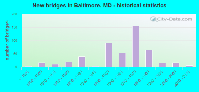
- New bridges - historical statistics
- 2Before 1900
- 161900-1909
- 111910-1919
- 201920-1929
- 391930-1939
- 21940-1949
- 911950-1959
- 541960-1969
- 1561970-1979
- 641980-1989
- 151990-1999
- 162000-2009
- 62010-2019
- 12020-2022
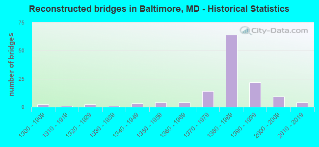
- Reconstructed bridges - Historical Statistics
- 21900-1909
- 11910-1919
- 21920-1929
- 11930-1939
- 31940-1949
- 41950-1959
- 41960-1969
- 141970-1979
- 641980-1989
- 221990-1999
- 92000-2009
- 42010-2019

- Bridge Condition - Deck
- 2.1%Very good
- 48.6%Good
- 34.5%Satisfactory
- 11.1%Fair
- 3.0%Poor
- 0.6%Serious
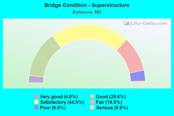
- Bridge Condition - Superstructure
- 4.0%Very good
- 25.6%Good
- 44.0%Satisfactory
- 19.5%Fair
- 6.0%Poor
- 0.9%Serious
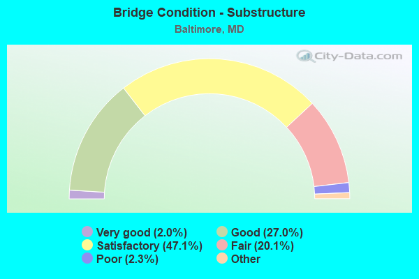
- Bridge Condition - Substructure
- 2.0%Very good
- 27.0%Good
- 47.1%Satisfactory
- 20.1%Fair
- 2.3%Poor
- 1.4%Serious
- 0.9%Critical
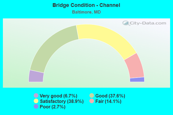
- Bridge Condition - Channel
- 6.7%Very good
- 37.6%Good
- 38.9%Satisfactory
- 14.1%Fair
- 2.7%Poor
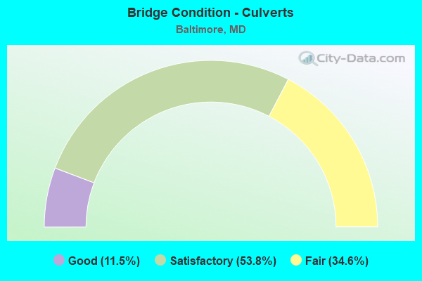
- Bridge Condition - Culverts
- 11.5%Good
- 53.8%Satisfactory
- 34.6%Fair
Find on map >> Show street view
Structure Number: 200000BC522101, Location: 0.2 MI S OF IS 95 (Lat: 39.268372, Lng: -76.635333), Route carried "on" structure: Ramp City street 295, Year Built: 1963, Status: Open, Structure Length: 6.31m (20.70ft), Average Daily Traffic: 16,520 (year 2007), Truck Traffic: 5%, Average Future Daily Traffic: 20,155 (year 2027), Design Load: HS 20, Features Intersected: CSX, Facility Carried by Structure: MONROE STREET RAMP
Minimum Vertical Clearance: 30+ m (98+ ft), Kilometerpoint: 2.076, Lanes on structure: 2, Owner: City or Municipal Highway Agency, Approaching Roadway Width: 7.9m (25.9ft), Skew: 4 degrees, Material/Design: Steel, Design/Construction: Stringer/Multi-beam, Number Of Spans In Main Unit: 3, Length of Maximum Span: 22.9m (75.1ft), Curb-To-Curb Width: 7.9m (25.9ft), Out-to-Out Width: 9.4m (30.8ft)
Condition: Deck: Fair, Superstructure: Poor, Substructure: Fair, Operating Rating: 60.3 metric tons, Method Used To Determine Operating Rating: Load Factor (LF), Inventory Rating: 36.3 metric tons, Method Used To Determine Inventory Rating: Load Factor (LF), Structural Evaluation: Meets minimum limits, Deck Geometry: High priority of replacement, Underclear: Better than present minimum criteria, Approach Roadway Alignment: Equal to present desirable criteria, Length Of Structure Improvement: 6.31m (20.70ft), Designated Inspection Frequency: Every 24 months, Inspection Date: October 2020, Bridge Improvement Cost: $170,000, Roadway Improvement Cost: $18,000, Total Project Cost: $188,000, Deck Structure Type: Concrete Cast-file-Place, Wearing Surface/Protective System: Wearing Surface: Bituminous
Find on map >> Show street view
Structure Number: 200000BC522201, Location: MONROE ST & ANNAP RD (Lat: 39.268583, Lng: -76.631667), Route carried "on" structure: City street 43, Year Built: 1975, Status: Open, Structure Length: 5.52m (18.11ft), Average Daily Traffic: 19,110 (year 2016), Truck Traffic: 5%, Average Future Daily Traffic: 23,310 (year 2036), Design Load: HS 20, Features Intersected: GWYNNS FALLS, Facility Carried by Structure: RELOCATED MONROE S
Minimum Vertical Clearance: 30+ m (98+ ft), Kilometerpoint: 2.076, Lanes on structure: 3, Owner: City or Municipal Highway Agency, Approaching Roadway Width: 11.9m (39.0ft), Material/Design: Steel continuous, Design/Construction: Stringer/Multi-beam, Number Of Spans In Main Unit: 2, Length of Maximum Span: 27.1m (88.9ft), Curb or Sidewalk Widths: Left: 0.0m, Right: 2.1m (6.9ft), Curb-To-Curb Width: 11.9m (39.0ft), Out-to-Out Width: 14.8m (48.6ft)
Condition: Deck: Good, Superstructure: Satisfactory, Substructure: Satisfactory, Channel: Fair, Inventory Rating: 57.1 metric tons, Method Used To Determine Inventory Rating: Load Factor (LF), Structural Evaluation: Equal to present minimum criteria, Deck Geometry: High priority of corrective action, Waterway Adequacy: Superior to present desirable criteria, Approach Roadway Alignment: Equal to present desirable criteria, Length Of Structure Improvement: 5.52m (18.11ft), Designated Inspection Frequency: Every 24 months, Underwater Inspection Frequency: Every 60 months, Inspection Date: December 2020, Underwater Inspection Date: July 2018, Bridge Improvement Cost: $48,000, Roadway Improvement Cost: $5,000, Total Project Cost: $53,000, Deck Structure Type: Concrete Cast-file-Place, Wearing Surface/Protective System: Wearing Surface: Monolithic Concrete
Find on map >> Show street view
Structure Number: 200000BC525602, Location: 0.3 MI NE OF MONROE ST (Lat: 39.272286, Lng: -76.629792), Route carried "on" structure: State highway 295, Year Built: 1910, Status: Open, Structure Length: 0.76m (2.49ft), Average Daily Traffic: 2,125 (year 2007), Truck Traffic: 5%, Average Future Daily Traffic: 4,811 (year 2038), Features Intersected: SPRING GARDENS, Facility Carried by Structure: RUSSELL AND BUSH S
Minimum Vertical Clearance: 30+ m (98+ ft), Kilometerpoint: 0.209, Lanes on structure: 6, Owner: City or Municipal Highway Agency, Approaching Roadway Width: 25.6m (84.0ft), Material/Design: Masonry, Design/Construction: Arch - Deck, Number Of Spans In Main Unit: 1, Length of Maximum Span: 7.6m (24.9ft), Curb-To-Curb Width: 15.2m (49.9ft), Out-to-Out Width: 15.2m (49.9ft)
Condition: Superstructure: Fair, Substructure: Fair, Channel: Satisfactory, Operating Rating: 32.7 metric tons, Method Used To Determine Operating Rating: Field evaluation and documented engineering judgment, Inventory Rating: 32.7 metric tons, Method Used To Determine Inventory Rating: Field evaluation and documented engineering judgment, Structural Evaluation: Somewhat better than minimum adequacy, Deck Geometry: High priority of replacement, Waterway Adequacy: Superior to present desirable criteria, Approach Roadway Alignment: Equal to present desirable criteria, Length Of Structure Improvement: 0.76m (2.49ft), Designated Inspection Frequency: Every 24 months, Underwater Inspection Frequency: Every 60 months, Inspection Date: August 2020, Underwater Inspection Date: March 2020, Bridge Improvement Cost: $32,000, Roadway Improvement Cost: $511,000, Total Project Cost: $543,000
Find on map >> Show street view
Structure Number: 200000BC530101, Location: 0.1 MI E RUSSELL ST (Lat: 39.459808, Lng: -77.052981), Route carried "on" structure: City street 1950, Year Built: 1974, Status: Open, Structure Length: 5.73m (18.80ft), Average Daily Traffic: 9,896 (year 2007), Truck Traffic: 5%, Average Future Daily Traffic: 13,472 (year 2038), Features Intersected: GWYNNS FALLS, Facility Carried by Structure: ANNAPOLIS ROAD
Minimum Vertical Clearance: 12.50m (41.01ft), Kilometerpoint: 1.030, Lanes on structure: 2, Owner: City or Municipal Highway Agency, Approaching Roadway Width: 11.0m (36.1ft), Material/Design: Steel continuous, Design/Construction: Stringer/Multi-beam, Number Of Spans In Main Unit: 2, Length of Maximum Span: 28.0m (91.9ft), Curb or Sidewalk Widths: Left: 0.0m, Right: 1.2m (3.9ft), Curb-To-Curb Width: 11.0m (36.1ft), Out-to-Out Width: 13.0m (42.7ft)
Condition: Deck: Good, Superstructure: Good, Substructure: Satisfactory, Channel: Satisfactory, Structural Evaluation: Equal to present minimum criteria, Deck Geometry: Meets minimum limits, Waterway Adequacy: Equal to present desirable criteria, Approach Roadway Alignment: Equal to present desirable criteria, Length Of Structure Improvement: 5.73m (18.80ft), Designated Inspection Frequency: Every 24 months, Underwater Inspection Frequency: Every 48 months, Inspection Date: August 2020, Underwater Inspection Date: August 2018, Bridge Improvement Cost: $17,000, Roadway Improvement Cost: $5,000, Total Project Cost: $22,000, Deck Structure Type: Concrete Cast-file-Place, Wearing Surface/Protective System: Wearing Surface: Monolithic Concrete
Find on map >> Show street view
Structure Number: 200000BC540101, Location: 0.3 MI N OF PATAPSCO AVE (Lat: 39.253106, Lng: -76.638994), Route carried "on" structure: City street 648, Year Built: 1919, Year Reconstructed: 1949, Status: Closed, Structure Length: 9.30m (30.51ft), Average Daily Traffic: 16,650 (year 2014), Truck Traffic: 5%, Average Future Daily Traffic: 20,300 (year 2036), Design Load: HS 20, Features Intersected: MD 295, B/W PARKWAY, Facility Carried by Structure: ANNAPOLIS ROAD
Minimum Vertical Clearance: 30+ m (98+ ft), Kilometerpoint: 0.434, Lanes on structure: 2, Lanes under structure: 6, Owner: City or Municipal Highway Agency, Approaching Roadway Width: 11.0m (36.1ft), Skew: 3 degrees, Material/Design: Steel, Design/Construction: Stringer/Multi-beam, Number Of Spans In Main Unit: 4, Length of Maximum Span: 26.5m (86.9ft), Curb or Sidewalk Widths: Left: 1.6m (5.2ft), Right: 1.6m (5.2ft), Curb-To-Curb Width: 11.0m (36.1ft), Out-to-Out Width: 14.8m (48.6ft)
Condition: Deck: Poor, Superstructure: Serious, Substructure: Serious, Operating Rating: 40.8 metric tons, Method Used To Determine Operating Rating: Load Factor (LF), Inventory Rating: 24.5 metric tons, Method Used To Determine Inventory Rating: Load Factor (LF), Structural Evaluation: High priority of corrective action, Deck Geometry: Meets minimum limits, Underclear: Meets minimum limits, Approach Roadway Alignment: Equal to present minimum criteria, Length Of Structure Improvement: 9.30m (30.51ft), Designated Inspection Frequency: Every 12 months, Inspection Date: July 2018, Bridge Improvement Cost: $1,824,000, Roadway Improvement Cost: $1,000, Total Project Cost: $1,825,000, Deck Structure Type: Concrete Cast-file-Place, Wearing Surface/Protective System: Wearing Surface: Bituminous
Find on map >> Show street view
Structure Number: 200000BC540201, Location: 0.6 MI S OF I-95 (Lat: 39.260647, Lng: -76.635894), Route carried "on" structure: City street 1630, Year Built: 1950, Status: Open, Structure Length: 3.93m (12.89ft), Average Daily Traffic: 19,170 (year 2007), Truck Traffic: 5%, Average Future Daily Traffic: 23,390 (year 2027), Design Load: HS 20, Features Intersected: MD 295, BW PARKWAY, Facility Carried by Structure: WATERVIEW AVE
Minimum Vertical Clearance: 30+ m (98+ ft), Kilometerpoint: 1.609, Lanes on structure: 4, Lanes under structure: 6, Owner: City or Municipal Highway Agency, Approaching Roadway Width: 17.1m (56.1ft), Skew: 20 degrees, Material/Design: Steel, Design/Construction: Stringer/Multi-beam, Number Of Spans In Main Unit: 2, Length of Maximum Span: 21.0m (68.9ft), Curb or Sidewalk Widths: Left: 1.6m (5.2ft), Right: 1.6m (5.2ft), Curb-To-Curb Width: 17.1m (56.1ft), Out-to-Out Width: 21.4m (70.2ft)
Condition: Deck: Satisfactory, Superstructure: Fair, Substructure: Poor, Operating Rating: 73.5 metric tons, Method Used To Determine Operating Rating: Field evaluation and documented engineering judgment, Inventory Rating: 43.5 metric tons, Method Used To Determine Inventory Rating: Field evaluation and documented engineering judgment, Structural Evaluation: Meets minimum limits, Deck Geometry: Somewhat better than minimum adequacy, Underclear: Meets minimum limits, Approach Roadway Alignment: Equal to present minimum criteria, Length Of Structure Improvement: 3.93m (12.89ft), Designated Inspection Frequency: Every 24 months, Inspection Date: October 2020, Bridge Improvement Cost: $176,000, Roadway Improvement Cost: $3,000, Total Project Cost: $179,000, Deck Structure Type: Concrete Cast-file-Place, Wearing Surface/Protective System: Wearing Surface: Bituminous
Find on map >> Show street view
Structure Number: 200000BC540306, Location: 0.6 MI S IS 95 (Lat: 39.443961, Lng: -77.064094), Route carried "on" structure: Ramp City street 295, Year Built: 1950, Status: Open, Structure Length: 2.29m (7.51ft), Average Daily Traffic: 18,981 (year 2007), Truck Traffic: 5%, Average Future Daily Traffic: 22,777 (year 2027), Design Load: HS 20, Features Intersected: MD-295, B/W PARKWAY RAMP, Facility Carried by Structure: WATERVIEW AVENUE
Minimum Vertical Clearance: 30+ m (98+ ft), Kilometerpoint: 1.609, Lanes on structure: 4, Lanes under structure: 1, Owner: City or Municipal Highway Agency, Approaching Roadway Width: 17.1m (56.1ft), Skew: 24 degrees, Material/Design: Concrete, Design/Construction: Tee Beam, Number Of Spans In Main Unit: 1, Length of Maximum Span: 20.1m (65.9ft), Curb or Sidewalk Widths: Left: 1.6m (5.2ft), Right: 1.6m (5.2ft), Curb-To-Curb Width: 17.1m (56.1ft), Out-to-Out Width: 21.3m (69.9ft)
Condition: Deck: Fair, Superstructure: Poor, Substructure: Fair, Operating Rating: 49.4 metric tons, Method Used To Determine Operating Rating: Load Factor (LF), Inventory Rating: 29.9 metric tons, Method Used To Determine Inventory Rating: Load Factor (LF), Structural Evaluation: Meets minimum limits, Deck Geometry: Somewhat better than minimum adequacy, Underclear: Meets minimum limits, Approach Roadway Alignment: Equal to present minimum criteria, Length Of Structure Improvement: 2.29m (7.51ft), Designated Inspection Frequency: Every 12 months, Inspection Date: December 2021, Bridge Improvement Cost: $55,000, Roadway Improvement Cost: $10,000, Total Project Cost: $65,000, Deck Structure Type: Concrete Cast-file-Place
Find on map >> Show street view
Structure Number: 200000BC540401, Location: FORT AVE OVER KEY HWY (Lat: 39.271044, Lng: -76.599867), Route carried "on" structure: City street 1550, Year Built: 1930, Year Reconstructed: 1991, Status: Open, Structure Length: 2.53m (8.30ft), Average Daily Traffic: 12,140 (year 2016), Truck Traffic: 5%, Average Future Daily Traffic: 14,377 (year 2033), Design Load: HS 20, Features Intersected: KEY HIGHWAY, Facility Carried by Structure: FORT AVENUE
Minimum Vertical Clearance: 30+ m (98+ ft), Kilometerpoint: 1.384, Lanes on structure: 4, Lanes under structure: 4, Owner: City or Municipal Highway Agency, Approaching Roadway Width: 14.9m (48.9ft), Material/Design: Steel, Design/Construction: Stringer/Multi-beam, Number Of Spans In Main Unit: 1, Length of Maximum Span: 24.1m (79.1ft), Curb or Sidewalk Widths: Left: 3.0m (9.8ft), Right: 3.0m (9.8ft), Curb-To-Curb Width: 15.1m (49.5ft), Out-to-Out Width: 21.8m (71.5ft)
Condition: Deck: Good, Superstructure: Good, Substructure: Satisfactory, Inventory Rating: 63.5 metric tons, Method Used To Determine Inventory Rating: Load Factor (LF), Structural Evaluation: Equal to present minimum criteria, Deck Geometry: High priority of corrective action, Underclear: Equal to present minimum criteria, Approach Roadway Alignment: Equal to present desirable criteria, Length Of Structure Improvement: 2.53m (8.30ft), Designated Inspection Frequency: Every 24 months, Inspection Date: May 2020, Bridge Improvement Cost: $40,000, Roadway Improvement Cost: $1,000, Total Project Cost: $41,000, Deck Structure Type: Concrete Cast-file-Place, Wearing Surface/Protective System: Deck Protection: Epoxy Coated Reinforcing
Find on map >> Show street view
Structure Number: 200000BC540501, Location: 0.2 MI. W. OF FT. MCHENRY (Lat: 39.266889, Lng: -76.587917), Route carried "on" structure: City street 1550, Year Built: 1923, Year Reconstructed: 1993, Status: Open, Structure Length: 18.84m (61.81ft), Average Daily Traffic: 2,755 (year 2015), Truck Traffic: 5%, Average Future Daily Traffic: 3,263 (year 2032), Features Intersected: CSX, Facility Carried by Structure: FORT AVENUE
Minimum Vertical Clearance: 30+ m (98+ ft), Kilometerpoint: 0.000, Lanes on structure: 2, Lanes under structure: 2, Owner: City or Municipal Highway Agency, Approaching Roadway Width: 12.2m (40.0ft), Material/Design: Steel, Design/Construction: Stringer/Multi-beam, Number Of Spans In Main Unit: 7, Length of Maximum Span: 32.6m (107.0ft), Curb or Sidewalk Widths: Left: 1.5m (4.9ft), Right: 1.5m (4.9ft), Curb-To-Curb Width: 11.0m (36.1ft), Out-to-Out Width: 14.7m (48.2ft)
Condition: Deck: Satisfactory, Superstructure: Fair, Substructure: Poor, Inventory Rating: 55.3 metric tons, Method Used To Determine Inventory Rating: Load Factor (LF), Structural Evaluation: Meets minimum limits, Deck Geometry: Somewhat better than minimum adequacy, Underclear: High priority of corrective action, Approach Roadway Alignment: Equal to present desirable criteria, Length Of Structure Improvement: 18.78m (61.61ft), Designated Inspection Frequency: Every 24 months, Inspection Date: January 2021, Bridge Improvement Cost: $119,000, Roadway Improvement Cost: $26,000, Total Project Cost: $145,000 ( Estimate for 2016), Deck Structure Type: Concrete Cast-file-Place
Find on map >> Show street view
Structure Number: 200000BC540704, Location: WATERVIEW ANNAPO RD JCT (Lat: 39.259167, Lng: -76.636233), Route carried "on" structure: State highway 648, Year Built: 1920, Year Reconstructed: 1945, Status: Posted for load, Structure Length: 19.05m (62.50ft), Average Daily Traffic: 19,950 (year 2007), Truck Traffic: 5%, Average Future Daily Traffic: 24,885 (year 2028), Features Intersected: WATERVIEW AVENUE, Facility Carried by Structure: ANNAPOLIS ROAD
Minimum Vertical Clearance: 30+ m (98+ ft), Kilometerpoint: 1.609, Lanes on structure: 3, Owner: City or Municipal Highway Agency, Approaching Roadway Width: 7.3m (24.0ft), Material/Design: Steel, Design/Construction: Stringer/Multi-beam, Number Of Spans In Main Unit: 1, Length of Maximum Span: 7.3m (24.0ft), Curb or Sidewalk Widths: Left: 1.6m (5.2ft), Right: 1.6m (5.2ft), Curb-To-Curb Width: 11.0m (36.1ft), Out-to-Out Width: 14.6m (47.9ft)
Condition: Deck: Poor, Superstructure: Satisfactory, Substructure: Good, Operating Rating: 10.0 metric tons, Method Used To Determine Operating Rating: Allowable Stress (AS), Inventory Rating: 5.9 metric tons, Method Used To Determine Inventory Rating: Allowable Stress (AS), Structural Evaluation: High priority of corrective action, Deck Geometry: High priority of replacement, Approach Roadway Alignment: Equal to present minimum criteria, Bridge Posting: Required (Relationship of Operating Rating to Maximum Legal Load: > 39.9% below), Length Of Structure Improvement: 19.05m (62.50ft), Designated Inspection Frequency: Every 12 months, Inspection Date: January 2021, Bridge Improvement Cost: $810,000, Roadway Improvement Cost: $17,000, Total Project Cost: $827,000, Deck Structure Type: Concrete Cast-file-Place, Wearing Surface/Protective System: Wearing Surface: Bituminous
Find on map >> Show street view
Structure Number: 200000BC555502, Location: CHESAPEAKE AVE W OF 8THST (Lat: 39.239417, Lng: -76.596194), Route carried "on" structure: City street 4355, Year Built: 1920, Year Reconstructed: 1950, Status: Open, Structure Length: 0.67m (2.20ft), Average Daily Traffic: 3,951 (year 2016), Truck Traffic: 5%, Average Future Daily Traffic: 5,988 (year 2037), Features Intersected: TRIB. TO PATAPSCO RIVER, Facility Carried by Structure: CHESAPEAKE AVENUE
Minimum Vertical Clearance: 30+ m (98+ ft), Kilometerpoint: 1.158, Lanes on structure: 2, Owner: City or Municipal Highway Agency, Approaching Roadway Width: 11.0m (36.1ft), Skew: 1 degrees, Material/Design: Concrete, Design/Construction: Culvert, Length of Maximum Span: 3.4m (11.2ft)
Condition: Channel: Fair, Culverts: Fair, Operating Rating: 32.7 metric tons, Method Used To Determine Operating Rating: Field evaluation and documented engineering judgment, Inventory Rating: 32.7 metric tons, Method Used To Determine Inventory Rating: Field evaluation and documented engineering judgment, Structural Evaluation: Somewhat better than minimum adequacy, Waterway Adequacy: Equal to present desirable criteria, Approach Roadway Alignment: Equal to present desirable criteria, Length Of Structure Improvement: 0.67m (2.20ft), Designated Inspection Frequency: Every 24 months, Inspection Date: April 2020, Bridge Improvement Cost: $25,000, Roadway Improvement Cost: $27,000, Total Project Cost: $52,000
Find on map >> Show street view
Structure Number: 200000BC640001, Location: 1.5 MI E OF MD 161 (Lat: 39.616136, Lng: -76.170342), Route carried "on" structure: ServiceCity street , Year Built: 1962, Status: Open, Structure Length: 1.68m (5.51ft), Average Daily Traffic: 11 (year 2016), Average Future Daily Traffic: 13 (year 2036), Design Load: H 20, Features Intersected: ELBOW BRANCH, Facility Carried by Structure: SERVICE ROAD
Minimum Vertical Clearance: 30+ m (98+ ft), Kilometerpoint: 0.000, Lanes on structure: 2, Owner: City or Municipal Highway Agency, Approaching Roadway Width: 6.1m (20.0ft), Material/Design: Steel, Design/Construction: Stringer/Multi-beam, Number Of Spans In Main Unit: 1, Length of Maximum Span: 15.2m (49.9ft), Curb or Sidewalk Widths: Left: 0.5m (1.6ft), Right: 0.5m (1.6ft), Curb-To-Curb Width: 6.1m (20.0ft), Out-to-Out Width: 7.6m (24.9ft)
Condition: Deck: Fair, Superstructure: Satisfactory, Substructure: Good, Channel: Satisfactory, Inventory Rating: 60.8 metric tons, Method Used To Determine Inventory Rating: Load Factor (LF), Structural Evaluation: Equal to present minimum criteria, Waterway Adequacy: Superior to present desirable criteria, Approach Roadway Alignment: Equal to present minimum criteria, Length Of Structure Improvement: 1.68m (5.51ft), Designated Inspection Frequency: Every 24 months, Inspection Date: October 2020, Bridge Improvement Cost: $14,000, Roadway Improvement Cost: $12,000, Total Project Cost: $26,000, Deck Structure Type: Concrete Cast-file-Place, Wearing Surface/Protective System: Wearing Surface: Bituminous
Find on map >> Show street view
Structure Number: 200000BC650101, Location: 0.2 MI E YORK RD (Lat: 39.825747, Lng: -77.078342), Route carried "on" structure: County highway 361, Year Built: 1922, Year Reconstructed: 1986, Status: Open, Structure Length: 2.80m (9.19ft), Average Daily Traffic: 9,956 (year 2020), Truck Traffic: 5%, Average Future Daily Traffic: 12,056 (year 2040), Design Load: H 20, Features Intersected: WESTERN RUN, Facility Carried by Structure: ASHLAND ROAD
Minimum Vertical Clearance: 30+ m (98+ ft), Kilometerpoint: 0.418, Lanes on structure: 2, Owner: City or Municipal Highway Agency, Approaching Roadway Width: 7.3m (24.0ft), Material/Design: Steel, Design/Construction: Stringer/Multi-beam, Number Of Spans In Main Unit: 1, Length of Maximum Span: 28.0m (91.9ft), Curb-To-Curb Width: 9.1m (29.9ft), Out-to-Out Width: 10.1m (33.1ft)
Condition: Deck: Good, Superstructure: Good, Substructure: Satisfactory, Channel: Satisfactory, Inventory Rating: 56.7 metric tons, Method Used To Determine Inventory Rating: Load Factor (LF), Structural Evaluation: Equal to present minimum criteria, Deck Geometry: High priority of corrective action, Waterway Adequacy: Equal to present desirable criteria, Approach Roadway Alignment: Equal to present minimum criteria, Length Of Structure Improvement: 4.45m (14.60ft), Designated Inspection Frequency: Every 24 months, Inspection Date: December 2020, Bridge Improvement Cost: $51,000, Roadway Improvement Cost: $34,000, Total Project Cost: $85,000, Deck Structure Type: Concrete Cast-file-Place, Wearing Surface/Protective System: Deck Protection: Epoxy Coated Reinforcing
Find on map >> Show street view
Structure Number: 200000BC650301, Location: 0.09 MI W CROMWELL BRDG R (Lat: 39.422306, Lng: -76.538447), Route carried "on" structure: City street 1492, Year Built: 1900, Year Reconstructed: 2007, Status: Posted for load, Structure Length: 1.01m (3.31ft), Average Daily Traffic: 309 (year 2012), Truck Traffic: 5%, Average Future Daily Traffic: 366 (year 2029), Features Intersected: MINEBANK RUN, Facility Carried by Structure: LOCH RAVEN DRIVE
Minimum Vertical Clearance: 30+ m (98+ ft), Kilometerpoint: 0.145, Lanes on structure: 2, Owner: City or Municipal Highway Agency, Approaching Roadway Width: 5.5m (18.0ft), Material/Design: Steel, Design/Construction: Stringer/Multi-beam, Number Of Spans In Main Unit: 1, Length of Maximum Span: 9.1m (29.9ft), Curb-To-Curb Width: 5.5m (18.0ft), Out-to-Out Width: 5.9m (19.4ft)
Condition: Deck: Good, Superstructure: Satisfactory, Substructure: Good, Channel: Satisfactory, Operating Rating: 22.7 metric tons, Method Used To Determine Operating Rating: Field evaluation and documented engineering judgment, Inventory Rating: 13.6 metric tons, Method Used To Determine Inventory Rating: Field evaluation and documented engineering judgment, Structural Evaluation: Meets minimum limits, Deck Geometry: High priority of corrective action, Waterway Adequacy: Equal to present desirable criteria, Approach Roadway Alignment: Equal to present minimum criteria, Bridge Posting: Required (Relationship of Operating Rating to Maximum Legal Load: 20.0 - 29.9% below), Length Of Structure Improvement: 1.01m (3.31ft), Designated Inspection Frequency: Every 24 months, Inspection Date: October 2020, Bridge Improvement Cost: $71,000, Roadway Improvement Cost: $2,000, Total Project Cost: $73,000, Deck Structure Type: Concrete Cast-file-Place, Wearing Surface/Protective System: Wearing Surface: Monolithic Concrete
Find on map >> Show street view
Structure Number: 200000BC650401, Location: 0.03 MI N PAPER MILL RD (Lat: 39.507014, Lng: -76.613886), Route carried "on" structure: City street 241, Year Built: 1967, Status: Open, Structure Length: 1.71m (5.61ft), Average Daily Traffic: 1,207 (year 2016), Truck Traffic: 5%, Average Future Daily Traffic: 1,294 (year 2033), Design Load: HS 20, Features Intersected: GREENE'S BRANCH, Facility Carried by Structure: PHOENIX ROAD
Minimum Vertical Clearance: 30+ m (98+ ft), Kilometerpoint: 4.586, Lanes on structure: 2, Owner: City or Municipal Highway Agency, Approaching Roadway Width: 9.1m (29.9ft), Material/Design: Steel, Design/Construction: Stringer/Multi-beam, Number Of Spans In Main Unit: 1, Length of Maximum Span: 15.9m (52.2ft), Curb-To-Curb Width: 9.1m (29.9ft), Out-to-Out Width: 10.7m (35.1ft)
Condition: Deck: Good, Superstructure: Fair, Substructure: Satisfactory, Channel: Fair, Operating Rating: 78.9 metric tons, Method Used To Determine Operating Rating: Load Factor (LF), Inventory Rating: 47.2 metric tons, Method Used To Determine Inventory Rating: Load Factor (LF), Structural Evaluation: Somewhat better than minimum adequacy, Deck Geometry: Somewhat better than minimum adequacy, Waterway Adequacy: Somewhat better than minimum adequacy, Approach Roadway Alignment: Equal to present desirable criteria, Length Of Structure Improvement: 1.71m (5.61ft), Designated Inspection Frequency: Every 24 months, Inspection Date: November 2020, Bridge Improvement Cost: $18,000, Roadway Improvement Cost: $10,000, Total Project Cost: $28,000, Deck Structure Type: Concrete Cast-file-Place, Wearing Surface/Protective System: Wearing Surface: Bituminous
Find on map >> Show street view
Structure Number: 200000BC650701, Location: 1.3 MI E YORK RD (Lat: 39.523675, Lng: -76.623631), Route carried "on" structure: City street 241, Year Built: 1922, Year Reconstructed: 1982, Status: Temporarily open, Structure Length: 13.32m (43.70ft), Average Daily Traffic: 2,174 (year 2015), Truck Traffic: 5%, Average Future Daily Traffic: 2,653 (year 2035), Design Load: HS 20, Features Intersected: GUNPOWDER FALLS, Facility Carried by Structure: PHOENIX ROAD
Minimum Vertical Clearance: 30+ m (98+ ft), Kilometerpoint: 2.220, Lanes on structure: 1, Owner: City or Municipal Highway Agency, Approaching Roadway Width: 5.5m (18.0ft), Material/Design: Steel, Design/Construction: Truss - Deck, Number Of Spans In Main Unit: 6, Length of Maximum Span: 21.3m (69.9ft), Curb-To-Curb Width: 3.7m (12.1ft), Out-to-Out Width: 6.8m (22.3ft)
Condition: Deck: Good, Superstructure: Poor, Substructure: Fair, Channel: Satisfactory, Operating Rating: 36.7 metric tons, Method Used To Determine Operating Rating: Load Factor (LF), Inventory Rating: 21.8 metric tons, Method Used To Determine Inventory Rating: Load Factor (LF), Structural Evaluation: Meets minimum limits, Deck Geometry: High priority of replacement, Waterway Adequacy: Superior to present desirable criteria, Approach Roadway Alignment: High priority of corrective action, Length Of Structure Improvement: 13.32m (43.70ft), Designated Inspection Frequency: Every 24 months, Inspection Date: March 2020, Bridge Improvement Cost: $1,627,000, Roadway Improvement Cost: $9,000, Total Project Cost: $1,636,000 ( Estimate for 2016), Deck Structure Type: Concrete Cast-file-Place, Wearing Surface/Protective System: Wearing Surface: Monolithic Concrete
Find on map >> Show street view
Structure Number: 200000BC651001, Location: 2.3 MI E YORK RD (Lat: 39.821781, Lng: -77.017008), Route carried "on" structure: County highway 7015, Year Built: 1923, Year Reconstructed: 1994, Status: Posted for load, Structure Length: 19.51m (64.01ft), Average Daily Traffic: 6,110 (year 2021), Truck Traffic: 5%, Average Future Daily Traffic: 7,455 (year 2041), Design Load: HS 20, Features Intersected: GUNPOWDER FALLS, Facility Carried by Structure: WARREN ROAD
Minimum Vertical Clearance: 30+ m (98+ ft), Kilometerpoint: 3.714, Lanes on structure: 2, Owner: City or Municipal Highway Agency, Approaching Roadway Width: 6.1m (20.0ft), Material/Design: Steel, Design/Construction: Truss - Thru, Number Of Spans In Main Unit: 3, Length of Maximum Span: 64.9m (212.9ft), Curb-To-Curb Width: 6.1m (20.0ft), Out-to-Out Width: 6.6m (21.7ft)
Condition: Deck: Satisfactory, Superstructure: Poor, Substructure: Fair, Channel: Good, Operating Rating: 27.7 metric tons, Method Used To Determine Operating Rating: Load Factor (LF), Inventory Rating: 16.8 metric tons, Method Used To Determine Inventory Rating: Load Factor (LF), Structural Evaluation: Meets minimum limits, Deck Geometry: High priority of replacement, Waterway Adequacy: Superior to present desirable criteria, Approach Roadway Alignment: Somewhat better than minimum adequacy, Bridge Posting: Required (Relationship of Operating Rating to Maximum Legal Load: 10.0 - 19.9% below), Length Of Structure Improvement: 19.51m (64.01ft), Designated Inspection Frequency: Every 24 months, Critical Feature Inspection Frequency: Every 24 months, Underwater Inspection Frequency: Every 60 months, Other Special Inspection Frequency: Every 12 months, Inspection Date: November 2021, Critical Feature Inspection Date: November 2021, Underwater Inspection Date: November 2018, Other Special Inspection Date: November 2021, Bridge Improvement Cost: $870,000, Roadway Improvement Cost: $10,000, Total Project Cost: $880,000, Deck Structure Type: Open Grating
Find on map >> Show street view
Structure Number: 200000BC651701, Location: 2.3 MI S MD.-PA. ST LINE (Lat: 39.688964, Lng: -76.780308), Route carried "on" structure: City street 4580, Year Built: 1968, Year Reconstructed: 1990, Status: Open, Structure Length: 5.30m (17.39ft), Average Daily Traffic: 160 (year 2020), Truck Traffic: 5%, Average Future Daily Traffic: 220 (year 2040), Features Intersected: GUNPOWDER FALLS, Facility Carried by Structure: GUNPOWDER ROAD
Minimum Vertical Clearance: 30+ m (98+ ft), Kilometerpoint: 11.585, Lanes on structure: 2, Owner: City or Municipal Highway Agency, Approaching Roadway Width: 11.0m (36.1ft), Skew: 4 degrees, Material/Design: Steel, Design/Construction: Stringer/Multi-beam, Number Of Spans In Main Unit: 3, Length of Maximum Span: 17.1m (56.1ft), Curb-To-Curb Width: 9.1m (29.9ft), Out-to-Out Width: 10.7m (35.1ft)
Condition: Deck: Good, Superstructure: Fair, Substructure: Fair, Channel: Good, Inventory Rating: 61.2 metric tons, Method Used To Determine Inventory Rating: Load Factor (LF), Structural Evaluation: Somewhat better than minimum adequacy, Deck Geometry: Equal to present minimum criteria, Waterway Adequacy: Equal to present desirable criteria, Approach Roadway Alignment: Equal to present minimum criteria, Designated Inspection Frequency: Every 24 months, Inspection Date: October 2020, Deck Structure Type: Concrete Cast-file-Place, Wearing Surface/Protective System: Wearing Surface: Monolithic Concrete, Deck Protection: Epoxy Coated Reinforcing
Find on map >> Show street view
Structure Number: 200000BC651901, Location: 0.3 MI E GUNPOWDER RD (Lat: 39.680056, Lng: -76.770583), Route carried "on" structure: City street 4570, Year Built: 1931, Year Reconstructed: 1988, Status: Open, Structure Length: 11.46m (37.60ft), Average Daily Traffic: 260 (year 2007), Truck Traffic: 5%, Average Future Daily Traffic: 320 (year 2027), Features Intersected: PRETTYBOY RESERVOIR, Facility Carried by Structure: CLIPPER MILL ROAD
Minimum Vertical Clearance: 30+ m (98+ ft), Kilometerpoint: 0.692, Lanes on structure: 2, Owner: City or Municipal Highway Agency, Approaching Roadway Width: 6.1m (20.0ft), Material/Design: Steel, Design/Construction: Girder and Floorbeam System, Number Of Spans In Main Unit: 6, Length of Maximum Span: 18.9m (62.0ft), Curb-To-Curb Width: 6.1m (20.0ft), Out-to-Out Width: 7.0m (23.0ft)
Condition: Deck: Fair, Superstructure: Fair, Substructure: Poor, Channel: Good, Operating Rating: 80.3 metric tons, Method Used To Determine Operating Rating: Load Factor (LF), Inventory Rating: 48.1 metric tons, Method Used To Determine Inventory Rating: Load Factor (LF), Structural Evaluation: Meets minimum limits, Deck Geometry: Meets minimum limits, Waterway Adequacy: Superior to present desirable criteria, Approach Roadway Alignment: Equal to present minimum criteria, Length Of Structure Improvement: 11.46m (37.60ft), Designated Inspection Frequency: Every 24 months, Critical Feature Inspection Frequency: Every 24 months, Underwater Inspection Frequency: Every 60 months, Inspection Date: April 2020, Critical Feature Inspection Date: April 2020, Underwater Inspection Date: April 2020, Bridge Improvement Cost: $50,000, Roadway Improvement Cost: $2,000, Total Project Cost: $52,000, Deck Structure Type: Concrete Cast-file-Place
Find on map >> Show street view
Structure Number: 200000BC652101, Location: 1.3 MI E FALLS RD (Lat: 39.625775, Lng: -76.772533), Route carried "on" structure: City street 122, Year Built: 2011, Status: Open, Structure Length: 3.20m (10.50ft), Average Daily Traffic: 155 (year 2007), Truck Traffic: 5%, Average Future Daily Traffic: 190 (year 2027), Features Intersected: GEORGES RUN, Facility Carried by Structure: GEORGES CREEK ROAD
Minimum Vertical Clearance: 30+ m (98+ ft), Kilometerpoint: 2.172, Lanes on structure: 2, Owner: City or Municipal Highway Agency, Approaching Roadway Width: 7.3m (24.0ft), Material/Design: Prestressed concrete, Design/Construction: Stringer/Multi-beam, Number Of Spans In Main Unit: 1, Length of Maximum Span: 32.0m (105.0ft), Curb-To-Curb Width: 7.3m (24.0ft), Out-to-Out Width: 8.2m (26.9ft)
Condition: Deck: Good, Superstructure: Good, Substructure: Good, Channel: Satisfactory, Operating Rating: 59.3 metric tons, Method Used To Determine Operating Rating: Load and Resistance Factor Rating (LRFR) rating reported by rating factor(RF) method using HL-93 loadings, Inventory Rating: 45.7 metric tons, Method Used To Determine Inventory Rating: Load and Resistance Factor Rating (LRFR) rating reported by rating factor(RF) method using HL-93 loadings, Structural Evaluation: Better than present minimum criteria, Deck Geometry: Somewhat better than minimum adequacy, Waterway Adequacy: Better than present minimum criteria, Approach Roadway Alignment: Equal to present desirable criteria, Designated Inspection Frequency: Every 24 months, Inspection Date: November 2020, Deck Structure Type: Concrete Cast-file-Place, Wearing Surface/Protective System: Wearing Surface: Monolithic Concrete, Deck Protection: Epoxy Coated Reinforcing
Find on map >> Show street view
Structure Number: 200000BC652201, Location: 0.8 MI N BECKLEYSVILLE RO (Lat: 39.654656, Lng: -76.779411), Route carried "on" structure: City street 4580, Year Built: 1990, Status: Open, Structure Length: 1.19m (3.90ft), Average Daily Traffic: 150 (year 2020), Truck Traffic: 6%, Average Future Daily Traffic: 210 (year 2040), Features Intersected: GRAVES RUN, Facility Carried by Structure: GUNPOWDER ROAD
Minimum Vertical Clearance: 30+ m (98+ ft), Kilometerpoint: 5.632, Lanes on structure: 2, Owner: City or Municipal Highway Agency, Approaching Roadway Width: 6.1m (20.0ft), Skew: 2 degrees, Material/Design: Concrete, Design/Construction: Culvert, Number Of Spans In Main Unit: 3, Length of Maximum Span: 3.4m (11.2ft), Curb-To-Curb Width: 6.1m (20.0ft), Out-to-Out Width: 6.1m (20.0ft)
Condition: Channel: Satisfactory, Culverts: Good, Operating Rating: 75.3 metric tons, Method Used To Determine Operating Rating: Load Factor (LF), Inventory Rating: 44.9 metric tons, Method Used To Determine Inventory Rating: Load Factor (LF), Structural Evaluation: Better than present minimum criteria, Waterway Adequacy: Better than present minimum criteria, Approach Roadway Alignment: Equal to present desirable criteria, Length Of Structure Improvement: 1.01m (3.31ft), Designated Inspection Frequency: Every 24 months, Inspection Date: October 2020, Total Project Cost: $1,000, Wearing Surface/Protective System: Wearing Surface: Bituminous, Deck Protection: Epoxy Coated Reinforcing
Find on map >> Show street view
Structure Number: 200000BC652301, Location: 0.8 MI E BECKLEYSVILLE RD (Lat: 39.655728, Lng: -76.740056), Route carried "on" structure: County highway 7027, Year Built: 2016, Status: Open, Structure Length: 2.13m (6.99ft), Average Daily Traffic: 95 (year 2007), Average Future Daily Traffic: 115 (year 2027), Features Intersected: COOPER'S RUN, Facility Carried by Structure: SPOOKS HILL ROAD
Minimum Vertical Clearance: 30+ m (98+ ft), Kilometerpoint: 3.459, Lanes on structure: 2, Owner: City or Municipal Highway Agency, Approaching Roadway Width: 7.6m (24.9ft), Material/Design: Prestressed concrete, Design/Construction: Stringer/Multi-beam, Number Of Spans In Main Unit: 1, Length of Maximum Span: 19.8m (65.0ft), Curb-To-Curb Width: 7.5m (24.6ft), Out-to-Out Width: 8.4m (27.6ft)
Condition: Deck: Very good, Superstructure: Very good, Substructure: Very good, Channel: Very good, Operating Rating: 32.7 metric tons, Method Used To Determine Operating Rating: Field evaluation and documented engineering judgment, Inventory Rating: 32.7 metric tons, Method Used To Determine Inventory Rating: Field evaluation and documented engineering judgment, Structural Evaluation: Equal to present desirable criteria, Deck Geometry: Equal to present minimum criteria, Waterway Adequacy: Superior to present desirable criteria, Approach Roadway Alignment: Equal to present desirable criteria, Designated Inspection Frequency: Every 24 months, Inspection Date: December 2020, Deck Structure Type: Concrete Cast-file-Place, Wearing Surface/Protective System: Wearing Surface: Monolithic Concrete, Deck Protection: Epoxy Coated Reinforcing
Find on map >> Show street view
Structure Number: 200000BC652401, Location: 1.3 MI W MIDDLETOWN RD (Lat: 39.644925, Lng: -76.720892), Route carried "on" structure: City street 4610, Year Built: 2001, Status: Open, Structure Length: 0.76m (2.49ft), Average Daily Traffic: 101 (year 2021), Truck Traffic: 1%, Average Future Daily Traffic: 303 (year 2041), Design Load: HS 25 or greater, Features Intersected: FROG HOLLOW RUN, Facility Carried by Structure: SPOOKS HILL ROAD
Minimum Vertical Clearance: 30+ m (98+ ft), Kilometerpoint: 6.597, Lanes on structure: 2, Owner: City or Municipal Highway Agency, Approaching Roadway Width: 6.4m (21.0ft), Material/Design: Concrete, Design/Construction: Slab, Number Of Spans In Main Unit: 1, Length of Maximum Span: 6.4m (21.0ft), Curb-To-Curb Width: 6.3m (20.7ft), Out-to-Out Width: 7.3m (24.0ft)
Condition: Deck: Good, Superstructure: Good, Substructure: Satisfactory, Channel: Satisfactory, Operating Rating: 86.2 metric tons, Method Used To Determine Operating Rating: Load Factor (LF), Inventory Rating: 51.7 metric tons, Method Used To Determine Inventory Rating: Load Factor (LF), Structural Evaluation: Equal to present minimum criteria, Deck Geometry: Meets minimum limits, Waterway Adequacy: Superior to present desirable criteria, Approach Roadway Alignment: Equal to present minimum criteria, Designated Inspection Frequency: Every 24 months, Inspection Date: December 2021, Wearing Surface/Protective System: Wearing Surface: Bituminous
Find on map >> Show street view
Structure Number: 200000BC652501, Location: 3 MI N CROMWELL BRDG RD (Lat: 37.466175, Lng: -76.545536), Route carried "on" structure: City street 146, Year Built: 2011, Status: Open, Structure Length: 1.49m (4.89ft), Average Daily Traffic: 10,100 (year 2007), Truck Traffic: 5%, Average Future Daily Traffic: 12,600 (year 2027), Features Intersected: DULANEY VALLEY BRANCH, Facility Carried by Structure: LOCH RAVEN DRIVE
Minimum Vertical Clearance: 30+ m (98+ ft), Kilometerpoint: 6.597, Lanes on structure: 2, Owner: City or Municipal Highway Agency, Approaching Roadway Width: 7.9m (25.9ft), Skew: 1 degrees, Material/Design: Prestressed concrete, Design/Construction: Box Beam or Girders - Multiple, Number Of Spans In Main Unit: 1, Length of Maximum Span: 13.7m (44.9ft), Curb-To-Curb Width: 8.2m (26.9ft), Out-to-Out Width: 9.1m (29.9ft)
Condition: Deck: Good, Superstructure: Very good, Substructure: Good, Channel: Satisfactory, Inventory Rating: 78.0 metric tons, Method Used To Determine Inventory Rating: Load Factor (LF), Structural Evaluation: Better than present minimum criteria, Deck Geometry: High priority of replacement, Waterway Adequacy: Equal to present desirable criteria, Approach Roadway Alignment: Equal to present minimum criteria, Designated Inspection Frequency: Every 24 months, Inspection Date: December 2021, Deck Structure Type: Concrete Cast-file-Place, Wearing Surface/Protective System: Wearing Surface: Monolithic Concrete, Deck Protection: Epoxy Coated Reinforcing
Find on map >> Show street view
Structure Number: 200000BC800101, Location: EAGER STREET AT FALLSWAY (Lat: 39.301217, Lng: -76.610619), Route carried "on" structure: City street 4260, Year Built: 1900, Year Reconstructed: 1990, Status: Open, Structure Length: 1.52m (4.99ft), Average Daily Traffic: 1,695 (year 2016), Truck Traffic: 5%, Average Future Daily Traffic: 2,008 (year 2033), Design Load: HS 20, Features Intersected: FALLSWAY, Facility Carried by Structure: EAGER STREET
Minimum Vertical Clearance: 30+ m (98+ ft), Kilometerpoint: 0.306, Lanes on structure: 3, Owner: City or Municipal Highway Agency, Approaching Roadway Width: 11.9m (39.0ft), Material/Design: Masonry, Design/Construction: Arch - Deck, Number Of Spans In Main Unit: 1, Length of Maximum Span: 15.2m (49.9ft), Curb or Sidewalk Widths: Left: 4.3m (14.1ft), Right: 4.3m (14.1ft), Curb-To-Curb Width: 11.9m (39.0ft), Out-to-Out Width: 21.2m (69.6ft)
Condition: Deck: Fair, Superstructure: Fair, Substructure: Fair, Operating Rating: 32.7 metric tons, Method Used To Determine Operating Rating: Field evaluation and documented engineering judgment, Inventory Rating: 32.7 metric tons, Method Used To Determine Inventory Rating: Field evaluation and documented engineering judgment, Structural Evaluation: Somewhat better than minimum adequacy, Deck Geometry: High priority of corrective action, Approach Roadway Alignment: Equal to present desirable criteria, Length Of Structure Improvement: 2.50m (8.20ft), Designated Inspection Frequency: Every 24 months, Inspection Date: August 2020, Bridge Improvement Cost: $23,000, Total Project Cost: $23,000, Wearing Surface/Protective System: Wearing Surface: Monolithic Concrete
Find on map >> Show street view
Structure Number: 200000BC800201, Location: UNDER IS 95 (Lat: 39.270306, Lng: -76.635278), Route carried "on" structure: Ramp Interstate 95, Year Built: 2006, Status: Open, Structure Length: 4.21m (13.81ft), Average Daily Traffic: 13,500 (year 2017), Truck Traffic: 8%, Average Future Daily Traffic: 16,600 (year 2037), Design Load: HS 25 or greater, Features Intersected: WALKWAY, Facility Carried by Structure: RUSSELL ST. SB RAM
Minimum Vertical Clearance: 30+ m (98+ ft), Kilometerpoint: 0.064, Lanes on structure: 1, Owner: City or Municipal Highway Agency, Approaching Roadway Width: 6.7m (22.0ft), Material/Design: Prestressed concrete, Design/Construction: Stringer/Multi-beam, Number Of Spans In Main Unit: 3, Length of Maximum Span: 13.7m (44.9ft), Curb or Sidewalk Widths: Left: 1.6m (5.2ft), Right: 0.0m, Curb-To-Curb Width: 7.0m (23.0ft), Out-to-Out Width: 9.3m (30.5ft)
Condition: Deck: Good, Superstructure: Very good, Substructure: Good, Operating Rating: 81.2 metric tons, Method Used To Determine Operating Rating: Load Factor (LF), Inventory Rating: 48.5 metric tons, Method Used To Determine Inventory Rating: Load Factor (LF), Structural Evaluation: Better than present minimum criteria, Deck Geometry: Equal to present minimum criteria, Approach Roadway Alignment: Equal to present desirable criteria, Length Of Structure Improvement: 3.93m (12.89ft), Designated Inspection Frequency: Every 24 months, Inspection Date: December 2021, Bridge Improvement Cost: $336,000, Roadway Improvement Cost: $40,000, Total Project Cost: $376,000, Deck Structure Type: Concrete Cast-file-Place
Find on map >> Show street view
Structure Number: 200000BC800301, Location: 1 MI S OF RTE 1 (Lat: 39.270072, Lng: -76.635608), Route carried "on" structure: Ramp City street 95, Year Built: 2006, Status: Open, Structure Length: 4.30m (14.11ft), Average Daily Traffic: 13,300 (year 2007), Truck Traffic: 8%, Average Future Daily Traffic: 16,600 (year 2034), Design Load: HS 25 or greater, Features Intersected: SERVICE ROAD, Facility Carried by Structure: MONROE ST RAMP EB
Minimum Vertical Clearance: 30+ m (98+ ft), Kilometerpoint: 0.290, Lanes on structure: 1, Lanes under structure: 2, Owner: City or Municipal Highway Agency, Approaching Roadway Width: 7.9m (25.9ft), Material/Design: Prestressed concrete continuous, Design/Construction: Stringer/Multi-beam, Number Of Spans In Main Unit: 3, Length of Maximum Span: 18.3m (60.0ft), Curb-To-Curb Width: 7.9m (25.9ft), Out-to-Out Width: 8.8m (28.9ft)
Condition: Deck: Good, Superstructure: Good, Substructure: Very good, Operating Rating: 78.5 metric tons, Method Used To Determine Operating Rating: Load Factor (LF), Inventory Rating: 47.2 metric tons, Method Used To Determine Inventory Rating: Load Factor (LF), Structural Evaluation: Better than present minimum criteria, Deck Geometry: Equal to present desirable criteria, Underclear: Meets minimum limits, Approach Roadway Alignment: Equal to present minimum criteria, Length Of Structure Improvement: 4.39m (14.40ft), Designated Inspection Frequency: Every 24 months, Inspection Date: October 2020, Bridge Improvement Cost: $213,000, Roadway Improvement Cost: $60,000, Total Project Cost: $273,000, Deck Structure Type: Concrete Cast-file-Place, Wearing Surface/Protective System: Wearing Surface: Bituminous
Find on map >> Show street view
Structure Number: 200000BC800402, Location: TRACEYS STORE RD/PRTTYBOY (Lat: 39.616186, Lng: -76.733686), Route carried "on" structure: County highway 7038, Year Built: 1932, Status: Open, Structure Length: 1.04m (3.41ft), Average Daily Traffic: 95 (year 2007), Average Future Daily Traffic: 125 (year 2027), Features Intersected: PRETTYBOY BRANCH, Facility Carried by Structure: TRACEY'S STORE ROA
Minimum Vertical Clearance: 30+ m (98+ ft), Kilometerpoint: 1.609, Lanes on structure: 2, Owner: City or Municipal Highway Agency, Approaching Roadway Width: 4.9m (16.1ft), Material/Design: Concrete, Design/Construction: Culvert, Number Of Spans In Main Unit: 2, Length of Maximum Span: 4.9m (16.1ft), Curb-To-Curb Width: 0.5m (1.6ft), Out-to-Out Width: 0.5m (1.6ft)
Condition: Channel: Poor, Culverts: Fair, Operating Rating: 75.3 metric tons, Method Used To Determine Operating Rating: Load Factor (LF), Inventory Rating: 44.9 metric tons, Method Used To Determine Inventory Rating: Load Factor (LF), Structural Evaluation: Somewhat better than minimum adequacy, Deck Geometry: High priority of replacement, Waterway Adequacy: Better than present minimum criteria, Approach Roadway Alignment: Equal to present desirable criteria, Length Of Structure Improvement: 1.04m (3.41ft), Designated Inspection Frequency: Every 24 months, Inspection Date: October 2020, Bridge Improvement Cost: $10,000, Roadway Improvement Cost: $8,000, Total Project Cost: $18,000
Find on map >> Show street view
Structure Number: 200000BC800502, Location: 0.3 MI W OF THE ALAMEDA (Lat: 39.365561, Lng: -76.599297), Route carried "on" structure: City street 1022, Year Built: 1974, Status: Open, Structure Length: 0.70m (2.30ft), Average Daily Traffic: 16,640 (year 2018), Truck Traffic: 5%, Average Future Daily Traffic: 23,572 (year 2038), Features Intersected: CHINQUAPIN RUN, Facility Carried by Structure: NORTHERN PARKWAY
Minimum Vertical Clearance: 30+ m (98+ ft), Kilometerpoint: 12.084, Lanes on structure: 5, Owner: City or Municipal Highway Agency, Approaching Roadway Width: 26.8m (87.9ft), Skew: 20 degrees, Material/Design: Concrete, Design/Construction: Culvert, Length of Maximum Span: 3.4m (11.2ft), Curb or Sidewalk Widths: Left: 1.8m (5.9ft), Right: 1.8m (5.9ft), Curb-To-Curb Width: 26.8m (87.9ft), Out-to-Out Width: 26.9m (88.3ft)
Condition: Channel: Satisfactory, Culverts: Satisfactory, Operating Rating: 89.8 metric tons, Method Used To Determine Operating Rating: Load Factor (LF), Inventory Rating: 38.1 metric tons, Method Used To Determine Inventory Rating: Load Factor (LF), Structural Evaluation: Equal to present minimum criteria, Deck Geometry: Superior to present desirable criteria, Waterway Adequacy: Equal to present desirable criteria, Approach Roadway Alignment: Equal to present desirable criteria, Length Of Structure Improvement: 5.40m (17.72ft), Designated Inspection Frequency: Every 24 months, Inspection Date: October 2020, Bridge Improvement Cost: $38,000, Roadway Improvement Cost: $12,000, Total Project Cost: $50,000
Find on map >> Show street view
Structure Number: 200000BC800602, Location: 0.3 MI N OF NORTHERN PKY (Lat: 39.370606, Lng: -76.583217), Route carried "on" structure: City street 542, Year Built: 1930, Year Reconstructed: 1950, Status: Open, Structure Length: 0.91m (2.99ft), Average Daily Traffic: 8,000 (year 2016), Truck Traffic: 5%, Average Future Daily Traffic: 9,950 (year 2036), Features Intersected: W BRANCH OF HERRING RUN, Facility Carried by Structure: LOCH RAVEN BOULEVA
Minimum Vertical Clearance: 30+ m (98+ ft), Kilometerpoint: 12.084, Lanes on structure: 4, Owner: City or Municipal Highway Agency, Approaching Roadway Width: 14.6m (47.9ft), Skew: 2 degrees, Material/Design: Concrete, Design/Construction: Culvert, Length of Maximum Span: 4.6m (15.1ft), Curb or Sidewalk Widths: Left: 1.2m (3.9ft), Right: 1.2m (3.9ft)
Condition: Channel: Satisfactory, Culverts: Fair, Operating Rating: 32.7 metric tons, Method Used To Determine Operating Rating: Field evaluation and documented engineering judgment, Inventory Rating: 32.7 metric tons, Method Used To Determine Inventory Rating: Field evaluation and documented engineering judgment, Structural Evaluation: Somewhat better than minimum adequacy, Waterway Adequacy: Somewhat better than minimum adequacy, Approach Roadway Alignment: Equal to present desirable criteria, Length Of Structure Improvement: 5.52m (18.11ft), Designated Inspection Frequency: Every 24 months, Inspection Date: April 2020, Bridge Improvement Cost: $31,000, Roadway Improvement Cost: $11,000, Total Project Cost: $42,000
Find on map >> Show street view
Structure Number: 200000BC800702, Location: 0.5 MI E OF CATON AVE (Lat: 39.276111, Lng: -76.662111), Route carried "on" structure: City street 4190, Year Built: 1950, Year Reconstructed: 1980, Status: Open, Structure Length: 0.82m (2.69ft), Average Daily Traffic: 9,700 (year 2007), Truck Traffic: 5%, Average Future Daily Traffic: 12,100 (year 2027), Design Load: HS 20, Features Intersected: MAIDENS CHOICE CREEK, Facility Carried by Structure: DUKELAND STREET
Minimum Vertical Clearance: 30+ m (98+ ft), Kilometerpoint: 0.274, Lanes on structure: 2, Owner: City or Municipal Highway Agency, Approaching Roadway Width: 12.2m (40.0ft), Skew: 1 degrees, Material/Design: Concrete, Design/Construction: Culvert, Length of Maximum Span: 4.3m (14.1ft), Curb or Sidewalk Widths: Left: 2.4m (7.9ft), Right: 2.4m (7.9ft)
Condition: Channel: Fair, Culverts: Satisfactory, Operating Rating: 32.7 metric tons, Method Used To Determine Operating Rating: Field evaluation and documented engineering judgment, Inventory Rating: 32.7 metric tons, Method Used To Determine Inventory Rating: Field evaluation and documented engineering judgment, Structural Evaluation: Equal to present minimum criteria, Waterway Adequacy: Equal to present minimum criteria, Approach Roadway Alignment: Equal to present desirable criteria, Length Of Structure Improvement: 0.82m (2.69ft), Designated Inspection Frequency: Every 24 months, Inspection Date: October 2020, Bridge Improvement Cost: $4,000, Roadway Improvement Cost: $2,000, Total Project Cost: $6,000
Find on map >> Show street view
Structure Number: 200000BC800801, Location: 0.5 M E OF FULTON AV (Lat: 39.302761, Lng: -76.635389), Route carried "on" structure: City street 7030, Year Built: 1900, Year Reconstructed: 1948, Status: Open, Structure Length: 3.54m (11.61ft), Average Daily Traffic: 3,290 (year 2013), Truck Traffic: 5%, Average Future Daily Traffic: 4,014 (year 2033), Design Load: H 20, Features Intersected: AMTRAK RAILROAD, Facility Carried by Structure: ARGYLE AVENUE
Minimum Vertical Clearance: 30+ m (98+ ft), Kilometerpoint: 0.434, Lanes on structure: 2, Owner: City or Municipal Highway Agency, Approaching Roadway Width: 11.0m (36.1ft), Skew: 1 degrees, Material/Design: Steel, Design/Construction: Stringer/Multi-beam, Number Of Spans In Main Unit: 3, Length of Maximum Span: 20.1m (65.9ft), Curb or Sidewalk Widths: Left: 3.4m (11.2ft), Right: 3.4m (11.2ft), Curb-To-Curb Width: 11.0m (36.1ft), Out-to-Out Width: 18.3m (60.0ft)
Condition: Deck: Satisfactory, Superstructure: Satisfactory, Substructure: Satisfactory, Operating Rating: 45.8 metric tons, Method Used To Determine Operating Rating: Load Factor (LF), Inventory Rating: 27.7 metric tons, Method Used To Determine Inventory Rating: Load Factor (LF), Structural Evaluation: Equal to present minimum criteria, Deck Geometry: Somewhat better than minimum adequacy, Underclear: High priority of corrective action, Approach Roadway Alignment: Equal to present minimum criteria, Length Of Structure Improvement: 3.54m (11.61ft), Designated Inspection Frequency: Every 24 months, Inspection Date: April 2020, Bridge Improvement Cost: $66,000, Roadway Improvement Cost: $16,000, Total Project Cost: $82,000, Deck Structure Type: Concrete Cast-file-Place, Wearing Surface/Protective System: Wearing Surface: Bituminous
Find on map >> Show street view
Structure Number: 200000BC800901, Location: 0.1 MI E OF MONROE ST (Lat: 39.302728, Lng: -76.644678), Route carried "on" structure: City street 7031, Year Built: 1997, Year Reconstructed: 2000, Status: Open, Structure Length: 3.66m (12.01ft), Average Daily Traffic: 2,813 (year 2013), Truck Traffic: 5%, Average Future Daily Traffic: 3,432 (year 2033), Design Load: HS 25 or greater, Features Intersected: AMTRAK RAILROAD, Facility Carried by Structure: MOUNT STREET
Minimum Vertical Clearance: 30+ m (98+ ft), Kilometerpoint: 0.129, Lanes on structure: 2, Owner: City or Municipal Highway Agency, Approaching Roadway Width: 12.2m (40.0ft), Material/Design: Prestressed concrete, Design/Construction: Stringer/Multi-beam, Number Of Spans In Main Unit: 1, Length of Maximum Span: 36.6m (120.1ft), Curb or Sidewalk Widths: Left: 1.8m (5.9ft), Right: 1.8m (5.9ft), Curb-To-Curb Width: 12.2m (40.0ft), Out-to-Out Width: 16.5m (54.1ft)
Condition: Deck: Good, Superstructure: Good, Substructure: Good, Operating Rating: 70.3 metric tons, Method Used To Determine Operating Rating: Load Factor (LF), Inventory Rating: 42.2 metric tons, Method Used To Determine Inventory Rating: Load Factor (LF), Structural Evaluation: Better than present minimum criteria, Deck Geometry: Equal to present minimum criteria, Underclear: High priority of corrective action, Approach Roadway Alignment: Equal to present minimum criteria, Length Of Structure Improvement: 4.97m (16.31ft), Designated Inspection Frequency: Every 24 months, Inspection Date: April 2020, Bridge Improvement Cost: $2,000, Total Project Cost: $2,000, Deck Structure Type: Concrete Cast-file-Place, Wearing Surface/Protective System: Wearing Surface: Monolithic Concrete
Find on map >> Show street view
Structure Number: 200000BC801001, Location: 0.2 MI E OF MONROE ST (Lat: 39.302403, Lng: -76.643814), Route carried "on" structure: City street 7032, Year Built: 1920, Status: Open, Structure Length: 0.94m (3.08ft), Average Daily Traffic: 2,813 (year 2013), Truck Traffic: 5%, Average Future Daily Traffic: 3,432 (year 2033), Features Intersected: AMTRAK RAILROAD, Facility Carried by Structure: NORTH VINCENT STRE
Minimum Vertical Clearance: 30+ m (98+ ft), Kilometerpoint: 0.402, Lanes on structure: 1, Owner: City or Municipal Highway Agency, Approaching Roadway Width: 5.8m (19.0ft), Material/Design: Masonry, Design/Construction: Arch - Deck, Number Of Spans In Main Unit: 1, Length of Maximum Span: 8.5m (27.9ft), Curb-To-Curb Width: 6.4m (21.0ft), Out-to-Out Width: 12.8m (42.0ft)
Condition: Superstructure: Satisfactory, Substructure: Satisfactory, Operating Rating: 32.7 metric tons, Method Used To Determine Operating Rating: Field evaluation and documented engineering judgment, Inventory Rating: 32.7 metric tons, Method Used To Determine Inventory Rating: Field evaluation and documented engineering judgment, Structural Evaluation: Equal to present minimum criteria, Deck Geometry: High priority of replacement, Underclear: High priority of corrective action, Approach Roadway Alignment: Equal to present desirable criteria, Length Of Structure Improvement: 0.94m (3.08ft), Designated Inspection Frequency: Every 24 months, Inspection Date: April 2020, Bridge Improvement Cost: $60,000, Roadway Improvement Cost: $46,000, Total Project Cost: $106,000, Wearing Surface/Protective System: Wearing Surface: Bituminous
Find on map >> Show street view
Structure Number: 200000BC801601, Location: 0.5 MI N HOWARD & 29TH ST (Lat: 39.328236, Lng: -76.622972), Route carried "on" structure: City street 1701, Year Built: 1930, Status: Open, Structure Length: 0.91m (2.99ft), Average Daily Traffic: 2,034 (year 2016), Truck Traffic: 5%, Average Future Daily Traffic: 2,482 (year 2036), Features Intersected: STONEY RUN, Facility Carried by Structure: SAN MARTIN DRIVE
Minimum Vertical Clearance: 30+ m (98+ ft), Kilometerpoint: 0.370, Lanes on structure: 2, Owner: City or Municipal Highway Agency, Approaching Roadway Width: 9.8m (32.2ft), Material/Design: Concrete, Design/Construction: Arch - Deck, Number Of Spans In Main Unit: 1, Length of Maximum Span: 9.1m (29.9ft), Curb-To-Curb Width: 9.2m (30.2ft), Out-to-Out Width: 10.6m (34.8ft)
Condition: Superstructure: Fair, Substructure: Fair, Channel: Satisfactory, Operating Rating: 66.2 metric tons, Method Used To Determine Operating Rating: Field evaluation and documented engineering judgment, Inventory Rating: 48.1 metric tons, Method Used To Determine Inventory Rating: Field evaluation and documented engineering judgment, Structural Evaluation: Somewhat better than minimum adequacy, Deck Geometry: Meets minimum limits, Waterway Adequacy: Superior to present desirable criteria, Approach Roadway Alignment: Equal to present minimum criteria, Length Of Structure Improvement: 0.88m (2.89ft), Designated Inspection Frequency: Every 24 months, Inspection Date: March 2020, Bridge Improvement Cost: $51,000, Roadway Improvement Cost: $10,000, Total Project Cost: $61,000, Wearing Surface/Protective System: Wearing Surface: Bituminous
Find on map >> Show street view
Structure Number: 200000BC801701, Location: REMINGTON AV/ABANDONED RR (Lat: 39.326658, Lng: -76.625711), Route carried "on" structure: City street 2230, Year Built: 1901, Year Reconstructed: 1983, Status: Open, Structure Length: 1.37m (4.49ft), Average Daily Traffic: 3,954 (year 2015), Truck Traffic: 5%, Average Future Daily Traffic: 4,825 (year 2035), Design Load: HS 20, Features Intersected: ABANDONED RAILROAD, Facility Carried by Structure: REMINGTON AVENUE
Minimum Vertical Clearance: 30+ m (98+ ft), Kilometerpoint: 0.611, Lanes on structure: 2, Owner: City or Municipal Highway Agency, Approaching Roadway Width: 12.2m (40.0ft), Skew: 3 degrees, Material/Design: Prestressed concrete, Design/Construction: Slab, Number Of Spans In Main Unit: 1, Length of Maximum Span: 12.5m (41.0ft), Curb or Sidewalk Widths: Left: 1.7m (5.6ft), Right: 1.7m (5.6ft), Curb-To-Curb Width: 12.4m (40.7ft), Out-to-Out Width: 16.4m (53.8ft)
Condition: Deck: Satisfactory, Superstructure: Satisfactory, Substructure: Fair, Operating Rating: 32.7 metric tons, Method Used To Determine Operating Rating: Field evaluation and documented engineering judgment, Inventory Rating: 32.7 metric tons, Method Used To Determine Inventory Rating: Field evaluation and documented engineering judgment, Structural Evaluation: Somewhat better than minimum adequacy, Deck Geometry: Equal to present minimum criteria, Approach Roadway Alignment: Equal to present desirable criteria, Length Of Structure Improvement: 1.37m (4.49ft), Designated Inspection Frequency: Every 24 months, Inspection Date: October 2020, Bridge Improvement Cost: $22,000, Roadway Improvement Cost: $20,000, Total Project Cost: $51,000, Wearing Surface/Protective System: Wearing Surface: Monolithic Concrete, Deck Protection: Epoxy Coated Reinforcing
Find on map >> Show street view
Structure Number: 200000BC801801, Location: LANCASTER ST AT CENTRAL A (Lat: 39.472911, Lng: -77.008461), Route carried "on" structure: City street 7034, Year Built: 1985, Year Reconstructed: 2017, Status: Open, Structure Length: 1.17m (3.84ft), Average Daily Traffic: 5,650 (year 2007), Truck Traffic: 5%, Average Future Daily Traffic: 6,900 (year 2027), Features Intersected: HARFORD RUN, Facility Carried by Structure: LANCASTER ST. AT C
Minimum Vertical Clearance: 30+ m (98+ ft), Kilometerpoint: 1.287, Lanes on structure: 2, Owner: City or Municipal Highway Agency, Approaching Roadway Width: 8.8m (28.9ft), Material/Design: Prestressed concrete, Design/Construction: Slab, Number Of Spans In Main Unit: 1, Length of Maximum Span: 10.4m (34.1ft), Curb-To-Curb Width: 19.2m (63.0ft), Out-to-Out Width: 19.2m (63.0ft)
Condition: Deck: Very good, Superstructure: Very good, Substructure: Good, Channel: Good, Operating Rating: 44.4 metric tons, Method Used To Determine Operating Rating: Field evaluation and documented engineering judgment, Inventory Rating: 32.7 metric tons, Method Used To Determine Inventory Rating: Field evaluation and documented engineering judgment, Structural Evaluation: Better than present minimum criteria, Deck Geometry: Superior to present desirable criteria, Waterway Adequacy: Better than present minimum criteria, Approach Roadway Alignment: Equal to present desirable criteria, Length Of Structure Improvement: 0.79m (2.59ft), Designated Inspection Frequency: Every 24 months, Underwater Inspection Frequency: Every 60 months, Inspection Date: December 2021, Underwater Inspection Date: December 2017, Bridge Improvement Cost: $7,000, Total Project Cost: $7,000, Deck Structure Type: Concrete Precast Panels, Wearing Surface/Protective System: Wearing Surface: Bituminous
Find on map >> Show street view
Structure Number: 200000BC802201, Location: FORT AVENUE OVER CSX RR (Lat: 39.269806, Lng: -76.596389), Route carried "on" structure: City street 1550, Year Built: 2012, Status: Open, Structure Length: 1.86m (6.10ft), Average Daily Traffic: 12,359 (year 2020), Truck Traffic: 5%, Average Future Daily Traffic: 15,080 (year 2040), Features Intersected: CSX, Facility Carried by Structure: FORT AVE
Minimum Vertical Clearance: 30+ m (98+ ft), Kilometerpoint: 2.494, Lanes on structure: 2, Owner: City or Municipal Highway Agency, Approaching Roadway Width: 15.2m (49.9ft), Material/Design: Steel, Design/Construction: Stringer/Multi-beam, Number Of Spans In Main Unit: 1, Length of Maximum Span: 17.4m (57.1ft), Curb or Sidewalk Widths: Left: 3.5m (11.5ft), Right: 3.5m (11.5ft), Curb-To-Curb Width: 15.1m (49.5ft), Out-to-Out Width: 25.1m (82.3ft)
Condition: Deck: Good, Superstructure: Good, Substructure: Good, Operating Rating: 84.6 metric tons, Method Used To Determine Operating Rating: Load and Resistance Factor Rating (LRFR) rating reported by rating factor(RF) method using HL-93 loadings, Inventory Rating: 65.4 metric tons, Method Used To Determine Inventory Rating: Load and Resistance Factor Rating (LRFR) rating reported by rating factor(RF) method using HL-93 loadings, Structural Evaluation: Better than present minimum criteria, Deck Geometry: Superior to present desirable criteria, Underclear: Somewhat better than minimum adequacy, Approach Roadway Alignment: Equal to present desirable criteria, Length Of Structure Improvement: 1.52m (4.99ft), Designated Inspection Frequency: Every 24 months, Inspection Date: September 2020, Bridge Improvement Cost: $25,000, Total Project Cost: $33,000 ( Estimate for 2016), Deck Structure Type: Concrete Cast-file-Place, Wearing Surface/Protective System: Wearing Surface: Monolithic Concrete, Deck Protection: Epoxy Coated Reinforcing