Bridge Statistics for Baltimore, Maryland (MD)
Condition, Traffic, Stress, Structural Evaluation, Project Costs
- National Bridge Inventory (NBI) Statistics
- 493Number of bridges
- 20,646ft / 6,293mTotal length
- $782,048,000Total costs
- 14,623,220Total average daily traffic
- 904,848Total average daily truck traffic
- National Bridge Inventory (NBI) Registered Bridges for Baltimore
- No street view available for this location
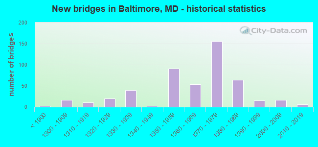
- New bridges - historical statistics
- 2Before 1900
- 161900-1909
- 111910-1919
- 201920-1929
- 391930-1939
- 21940-1949
- 911950-1959
- 541960-1969
- 1561970-1979
- 641980-1989
- 151990-1999
- 162000-2009
- 62010-2019
- 12020-2022
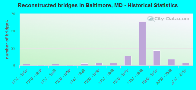
- Reconstructed bridges - Historical Statistics
- 21900-1909
- 11910-1919
- 21920-1929
- 11930-1939
- 31940-1949
- 41950-1959
- 41960-1969
- 141970-1979
- 641980-1989
- 221990-1999
- 92000-2009
- 42010-2019

- Bridge Condition - Deck
- 2.1%Very good
- 48.6%Good
- 34.5%Satisfactory
- 11.1%Fair
- 3.0%Poor
- 0.6%Serious
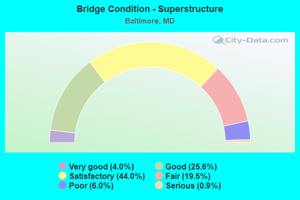
- Bridge Condition - Superstructure
- 4.0%Very good
- 25.6%Good
- 44.0%Satisfactory
- 19.5%Fair
- 6.0%Poor
- 0.9%Serious
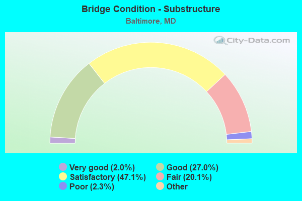
- Bridge Condition - Substructure
- 2.0%Very good
- 27.0%Good
- 47.1%Satisfactory
- 20.1%Fair
- 2.3%Poor
- 1.4%Serious
- 0.9%Critical
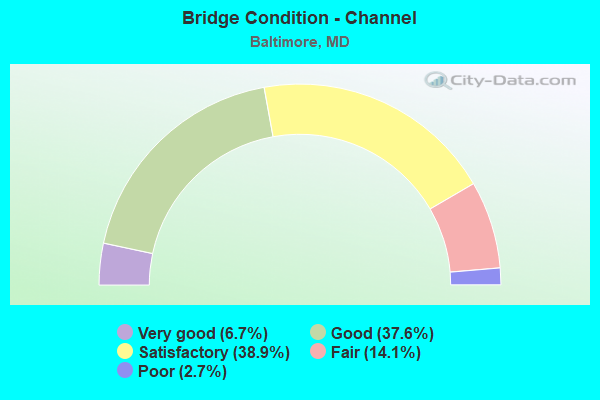
- Bridge Condition - Channel
- 6.7%Very good
- 37.6%Good
- 38.9%Satisfactory
- 14.1%Fair
- 2.7%Poor
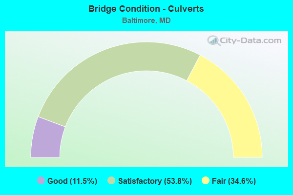
- Bridge Condition - Culverts
- 11.5%Good
- 53.8%Satisfactory
- 34.6%Fair
Find on map >> Show street view
Structure Number: 300000BCW54401, Location: 0.3 MI E RUSSELL ST (Lat: 39.268261, Lng: -76.629681), Route carried "on" structure: Ramp Interstate 95, Year Built: 1979, Status: Open, Structure Length: 25.76m (84.51ft), Average Daily Traffic: 35,059 (year 2019), Truck Traffic: 1%, Average Future Daily Traffic: 47,603 (year 2041), Design Load: HS 20, Features Intersected: OLD ANNAN RD,MIDDLE BR
Minimum Vertical Clearance: 30+ m (98+ ft), Kilometerpoint: 87.530, Lanes on structure: 2, Base Highway Network: Yes, Owner: State Toll Authority, Approaching Roadway Width: 12.8m (42.0ft), Material/Design: Steel continuous, Design/Construction: Stringer/Multi-beam, Number Of Spans In Main Unit: 6, Length of Maximum Span: 50.3m (165.0ft), Curb-To-Curb Width: 12.6m (41.3ft), Out-to-Out Width: 13.6m (44.6ft)
Condition: Deck: Satisfactory, Superstructure: Satisfactory, Substructure: Satisfactory, Operating Rating: 62.1 metric tons, Method Used To Determine Operating Rating: Load Factor (LF), Inventory Rating: 37.2 metric tons, Method Used To Determine Inventory Rating: Load Factor (LF), Structural Evaluation: Equal to present minimum criteria, Deck Geometry: Superior to present desirable criteria, Underclear: High priority of corrective action, Approach Roadway Alignment: Equal to present desirable criteria, Designated Inspection Frequency: Every 24 months, Inspection Date: November 2021, Deck Structure Type: Concrete Cast-file-Place, Wearing Surface/Protective System: Wearing Surface: Integral Concrete, Deck Protection: Epoxy Coated Reinforcing
Find on map >> Show street view
Structure Number: 300000BCW54501, Location: SB ON RAMP FROM I-395 SB (Lat: 39.268325, Lng: -76.625442), Route carried "on" structure: Ramp Interstate 95, Year Built: 1977, Status: Open, Structure Length: 14.81m (48.59ft), Average Daily Traffic: 34,476 (year 2019), Truck Traffic: 1%, Average Future Daily Traffic: 46,811 (year 2041), Design Load: HS 20, Features Intersected: MIDDLE BR, I 95 RAMP D
Minimum Vertical Clearance: 30+ m (98+ ft), Kilometerpoint: 0.000, Lanes on structure: 2, Lanes under structure: 1, Base Highway Network: Yes, Owner: State Toll Authority, Approaching Roadway Width: 12.8m (42.0ft), Material/Design: Steel continuous, Design/Construction: Stringer/Multi-beam, Number Of Spans In Main Unit: 3, Length of Maximum Span: 66.8m (219.2ft), Curb-To-Curb Width: 12.6m (41.3ft), Out-to-Out Width: 13.6m (44.6ft)
Condition: Deck: Satisfactory, Superstructure: Satisfactory, Substructure: Good, Channel: Good, Operating Rating: 73.0 metric tons, Method Used To Determine Operating Rating: Load Factor (LF), Inventory Rating: 43.5 metric tons, Method Used To Determine Inventory Rating: Load Factor (LF), Structural Evaluation: Equal to present minimum criteria, Deck Geometry: Superior to present desirable criteria, Underclear: Superior to present desirable criteria, Approach Roadway Alignment: Equal to present desirable criteria, Designated Inspection Frequency: Every 24 months, Underwater Inspection Frequency: Every 48 months, Inspection Date: October 2021, Underwater Inspection Date: January 2020, Deck Structure Type: Concrete Cast-file-Place, Wearing Surface/Protective System: Wearing Surface: Integral Concrete, Deck Protection: Epoxy Coated Reinforcing
Find on map >> Show street view
Structure Number: 300000BCW546011, Location: Milepost M52.6 (Lat: 39.267572, Lng: -76.626189), Route carried "on" structure: Interstate 95, Year Built: 1979, Status: Open, Structure Length: 43.56m (142.91ft), Average Daily Traffic: 60,992 (year 2019), Truck Traffic: 10%, Average Future Daily Traffic: 82,815 (year 2041), Design Load: HS 20, Features Intersected: MIDDLE BRANCH
Minimum Vertical Clearance: 4.88m (16.01ft), Kilometerpoint: 84.633, Lanes on structure: 4, Base Highway Network: Yes, Owner: State Toll Authority, Approaching Roadway Width: 18.0m (59.1ft), Navigation Control: Yes ( Vertical Clearance: 13.7m (44.9ft), Horizontal Clearance: 30.5m (100.1ft)), Material/Design: Steel continuous, Design/Construction: Stringer/Multi-beam, Number Of Spans In Main Unit: 10, Length of Maximum Span: 57.9m (190.0ft), Curb-To-Curb Width: 18.1m (59.4ft), Out-to-Out Width: 19.1m (62.7ft)
Condition: Deck: Good, Superstructure: Satisfactory, Substructure: Good, Channel: Good, Operating Rating: 66.7 metric tons, Method Used To Determine Operating Rating: Load Factor (LF), Inventory Rating: 39.9 metric tons, Method Used To Determine Inventory Rating: Load Factor (LF), Structural Evaluation: Equal to present minimum criteria, Deck Geometry: Meets minimum limits, Waterway Adequacy: Superior to present desirable criteria, Approach Roadway Alignment: Equal to present desirable criteria, Designated Inspection Frequency: Every 24 months, Underwater Inspection Frequency: Every 48 months, Inspection Date: August 2021, Underwater Inspection Date: November 2019, Deck Structure Type: Concrete Cast-file-Place, Wearing Surface/Protective System: Wearing Surface: Integral Concrete, Membrane: Other, Deck Protection: Other
Find on map >> Show street view
Structure Number: 300000BCW546012, Location: Milepost M52.8 (Lat: 39.267628, Lng: -76.625469), Route carried "on" structure: Interstate 95, Year Built: 1979, Status: Open, Structure Length: 42.67m (139.99ft), Average Daily Traffic: 68,141 (year 2019), Truck Traffic: 11%, Average Future Daily Traffic: 92,521 (year 2041), Design Load: HS 20, Features Intersected: MIDDLE BRANCH
Minimum Vertical Clearance: 5.49m (18.01ft), Kilometerpoint: 84.955, Lanes on structure: 4, Base Highway Network: Yes, Owner: State Toll Authority, Approaching Roadway Width: 21.9m (71.9ft), Navigation Control: Yes ( Vertical Clearance: 13.7m (44.9ft), Horizontal Clearance: 30.5m (100.1ft)), Material/Design: Steel continuous, Design/Construction: Stringer/Multi-beam, Number Of Spans In Main Unit: 9, Length of Maximum Span: 55.8m (183.1ft), Curb-To-Curb Width: 21.8m (71.5ft), Out-to-Out Width: 22.7m (74.5ft)
Condition: Deck: Satisfactory, Superstructure: Satisfactory, Substructure: Fair, Channel: Good, Operating Rating: 74.4 metric tons, Method Used To Determine Operating Rating: Load Factor (LF), Inventory Rating: 44.4 metric tons, Method Used To Determine Inventory Rating: Load Factor (LF), Structural Evaluation: Somewhat better than minimum adequacy, Deck Geometry: Meets minimum limits, Waterway Adequacy: Equal to present desirable criteria, Approach Roadway Alignment: Equal to present desirable criteria, Designated Inspection Frequency: Every 24 months, Underwater Inspection Frequency: Every 48 months, Inspection Date: October 2021, Underwater Inspection Date: November 2019, Deck Structure Type: Concrete Cast-file-Place, Wearing Surface/Protective System: Wearing Surface: Integral Concrete, Membrane: Other, Deck Protection: Other
Find on map >> Show street view
Structure Number: 300000BCW54701, Location: 0.6 MI E RUSSELL ST (Lat: 39.267281, Lng: -76.626411), Route carried "on" structure: Ramp Interstate 95, Year Built: 1980, Status: Open, Structure Length: 14.63m (48.00ft), Average Daily Traffic: 11,737 (year 2019), Truck Traffic: 5%, Average Future Daily Traffic: 15,937 (year 2041), Design Load: HS 20, Features Intersected: MIDDLE BRANCH
Minimum Vertical Clearance: 30+ m (98+ ft), Kilometerpoint: 88.012, Lanes on structure: 1, Base Highway Network: Yes, Owner: State Toll Authority, Approaching Roadway Width: 7.3m (24.0ft), Material/Design: Steel continuous, Design/Construction: Stringer/Multi-beam, Number Of Spans In Main Unit: 3, Length of Maximum Span: 56.4m (185.0ft), Curb-To-Curb Width: 7.3m (24.0ft), Out-to-Out Width: 8.3m (27.2ft)
Condition: Deck: Satisfactory, Superstructure: Satisfactory, Substructure: Good, Channel: Very good, Inventory Rating: 55.8 metric tons, Method Used To Determine Inventory Rating: Load Factor (LF), Structural Evaluation: Equal to present minimum criteria, Deck Geometry: Better than present minimum criteria, Approach Roadway Alignment: Equal to present desirable criteria, Designated Inspection Frequency: Every 24 months, Inspection Date: September 2021, Deck Structure Type: Concrete Cast-file-Place, Wearing Surface/Protective System: Wearing Surface: Integral Concrete, Membrane: Other, Deck Protection: Other
Find on map >> Show street view
Structure Number: 300000BCW54801, Location: SB OFF RAMP TO MD 295 SB (Lat: 39.267753, Lng: -76.624372), Route carried "on" structure: Ramp Interstate 95, Year Built: 1979, Status: Open, Structure Length: 12.71m (41.70ft), Average Daily Traffic: 15,504 (year 2019), Truck Traffic: 5%, Average Future Daily Traffic: 21,051 (year 2041), Design Load: HS 20, Features Intersected: MIDDLE BRNCH, LIGHT RAIL
Minimum Vertical Clearance: 8.53m (27.99ft), Kilometerpoint: 0.000, Lanes on structure: 1, Base Highway Network: Yes, Owner: State Toll Authority, Approaching Roadway Width: 7.3m (24.0ft), Material/Design: Steel continuous, Design/Construction: Stringer/Multi-beam, Number Of Spans In Main Unit: 4, Length of Maximum Span: 36.6m (120.1ft), Curb-To-Curb Width: 7.3m (24.0ft), Out-to-Out Width: 8.3m (27.2ft)
Condition: Deck: Satisfactory, Superstructure: Satisfactory, Substructure: Satisfactory, Channel: Good, Operating Rating: 73.5 metric tons, Method Used To Determine Operating Rating: Load Factor (LF), Inventory Rating: 44.0 metric tons, Method Used To Determine Inventory Rating: Load Factor (LF), Structural Evaluation: Equal to present minimum criteria, Deck Geometry: Better than present minimum criteria, Waterway Adequacy: Equal to present desirable criteria, Approach Roadway Alignment: Equal to present desirable criteria, Designated Inspection Frequency: Every 24 months, Inspection Date: November 2021, Deck Structure Type: Concrete Cast-file-Place, Wearing Surface/Protective System: Wearing Surface: Integral Concrete, Membrane: Other, Deck Protection: Other
Find on map >> Show street view
Structure Number: 300000BCW551011, Location: Milepost M52.8 (Lat: 39.266878, Lng: -76.614300), Route carried "on" structure: Interstate 95, Year Built: 1979, Status: Open, Structure Length: 60.75m (199.31ft), Average Daily Traffic: 66,316 (year 2019), Truck Traffic: 8%, Average Future Daily Traffic: 90,043 (year 2041), Design Load: HS 20, Features Intersected: RACE ST, HANOVER ST
Minimum Vertical Clearance: 30+ m (98+ ft), Kilometerpoint: 84.955, Lanes on structure: 4, Lanes under structure: 7, Base Highway Network: Yes, Owner: State Toll Authority, Approaching Roadway Width: 21.6m (70.9ft), Material/Design: Steel continuous, Design/Construction: Stringer/Multi-beam, Number Of Spans In Main Unit: 13, Length of Maximum Span: 54.9m (180.1ft), Curb-To-Curb Width: 21.8m (71.5ft), Out-to-Out Width: 22.7m (74.5ft)
Condition: Deck: Good, Superstructure: Satisfactory, Substructure: Good, Operating Rating: 45.4 metric tons, Method Used To Determine Operating Rating: Load Factor (LF), Inventory Rating: 27.2 metric tons, Method Used To Determine Inventory Rating: Load Factor (LF), Structural Evaluation: Equal to present minimum criteria, Deck Geometry: Better than present minimum criteria, Underclear: Somewhat better than minimum adequacy, Approach Roadway Alignment: Equal to present desirable criteria, Designated Inspection Frequency: Every 24 months, Inspection Date: January 2020, Deck Structure Type: Concrete Cast-file-Place, Wearing Surface/Protective System: Wearing Surface: Integral Concrete, Membrane: Other, Deck Protection: Other
Find on map >> Show street view
Structure Number: 300000BCW551012, Location: Milepost M53.1 (Lat: 39.266700, Lng: -76.615208), Route carried "on" structure: Interstate 95, Year Built: 1979, Status: Open, Structure Length: 56.45m (185.20ft), Average Daily Traffic: 73,769 (year 2019), Truck Traffic: 8%, Average Future Daily Traffic: 100,163 (year 2041), Design Load: HS 20, Features Intersected: RCE ST, HNVR ST, I95 RPJ
Minimum Vertical Clearance: 30+ m (98+ ft), Kilometerpoint: 85.438, Lanes on structure: 4, Lanes under structure: 7, Base Highway Network: Yes, Owner: State Toll Authority, Approaching Roadway Width: 21.6m (70.9ft), Material/Design: Steel continuous, Design/Construction: Stringer/Multi-beam, Number Of Spans In Main Unit: 13, Length of Maximum Span: 61.9m (203.1ft), Curb-To-Curb Width: 21.8m (71.5ft), Out-to-Out Width: 22.7m (74.5ft)
Condition: Deck: Good, Superstructure: Satisfactory, Substructure: Satisfactory, Operating Rating: 69.8 metric tons, Method Used To Determine Operating Rating: Load Factor (LF), Inventory Rating: 41.7 metric tons, Method Used To Determine Inventory Rating: Load Factor (LF), Structural Evaluation: Equal to present minimum criteria, Deck Geometry: Better than present minimum criteria, Underclear: Somewhat better than minimum adequacy, Approach Roadway Alignment: Equal to present desirable criteria, Designated Inspection Frequency: Every 24 months, Inspection Date: January 2020, Deck Structure Type: Concrete Cast-file-Place, Wearing Surface/Protective System: Wearing Surface: Integral Concrete, Membrane: Other, Deck Protection: Other
Find on map >> Show street view
Structure Number: 300000BCW55201, Location: Milepost M55.2 (Lat: 39.267428, Lng: -76.614400), Route carried "on" structure: Ramp Interstate 95, Year Built: 1979, Status: Open, Structure Length: 31.52m (103.41ft), Average Daily Traffic: 10,013 (year 2019), Truck Traffic: 3%, Average Future Daily Traffic: 13,596 (year 2041), Design Load: HS 20, Features Intersected: HANOVER ST, I-95
Minimum Vertical Clearance: 5.18m (16.99ft), Kilometerpoint: 88.817, Lanes on structure: 1, Lanes under structure: 4, Base Highway Network: Yes, Owner: State Toll Authority, Approaching Roadway Width: 7.3m (24.0ft), Material/Design: Steel continuous, Design/Construction: Stringer/Multi-beam, Number Of Spans In Main Unit: 10, Length of Maximum Span: 54.0m (177.2ft), Curb-To-Curb Width: 7.3m (24.0ft), Out-to-Out Width: 8.3m (27.2ft)
Condition: Deck: Good, Superstructure: Satisfactory, Substructure: Good, Operating Rating: 55.8 metric tons, Method Used To Determine Operating Rating: Load Factor (LF), Inventory Rating: 33.6 metric tons, Method Used To Determine Inventory Rating: Load Factor (LF), Structural Evaluation: Equal to present minimum criteria, Deck Geometry: Better than present minimum criteria, Underclear: Superior to present desirable criteria, Approach Roadway Alignment: Equal to present desirable criteria, Designated Inspection Frequency: Every 24 months, Inspection Date: January 2020, Deck Structure Type: Concrete Cast-file-Place, Wearing Surface/Protective System: Wearing Surface: Integral Concrete, Deck Protection: Epoxy Coated Reinforcing
Find on map >> Show street view
Structure Number: 300000BCW55301, Location: Milepost M55.3 (Lat: 39.266750, Lng: -76.616789), Route carried "on" structure: Ramp Interstate 95, Year Built: 1979, Status: Open, Structure Length: 34.72m (113.91ft), Average Daily Traffic: 10,039 (year 2019), Truck Traffic: 4%, Average Future Daily Traffic: 13,630 (year 2041), Design Load: HS 20, Features Intersected: WESTERN MD RR,McCOMAS ST
Minimum Vertical Clearance: 30+ m (98+ ft), Kilometerpoint: 88.978, Lanes on structure: 1, Lanes under structure: 2, Base Highway Network: Yes, Owner: State Toll Authority, Approaching Roadway Width: 7.3m (24.0ft), Material/Design: Steel continuous, Design/Construction: Stringer/Multi-beam, Number Of Spans In Main Unit: 12, Length of Maximum Span: 56.1m (184.1ft), Curb-To-Curb Width: 7.3m (24.0ft), Out-to-Out Width: 8.3m (27.2ft)
Condition: Deck: Satisfactory, Superstructure: Satisfactory, Substructure: Satisfactory, Operating Rating: 85.7 metric tons, Method Used To Determine Operating Rating: Load Factor (LF), Inventory Rating: 51.2 metric tons, Method Used To Determine Inventory Rating: Load Factor (LF), Structural Evaluation: Equal to present minimum criteria, Deck Geometry: Better than present minimum criteria, Underclear: Superior to present desirable criteria, Approach Roadway Alignment: Better than present minimum criteria, Designated Inspection Frequency: Every 24 months, Inspection Date: Febuary 2020, Deck Structure Type: Concrete Cast-file-Place, Wearing Surface/Protective System: Wearing Surface: Integral Concrete, Deck Protection: Epoxy Coated Reinforcing
Find on map >> Show street view
Structure Number: 300000BCW554011, Location: Milepost M53.2 (Lat: 39.267089, Lng: -76.608558), Route carried "on" structure: Interstate 95, Year Built: 1982, Status: Open, Structure Length: 76.20m (250.00ft), Average Daily Traffic: 58,406 (year 2019), Truck Traffic: 10%, Average Future Daily Traffic: 79,304 (year 2041), Design Load: HS 20, Features Intersected: WB MCCOMAS ST
Minimum Vertical Clearance: 30+ m (98+ ft), Kilometerpoint: 85.599, Lanes on structure: 4, Lanes under structure: 4, Base Highway Network: Yes, Owner: State Toll Authority, Approaching Roadway Width: 21.6m (70.9ft), Material/Design: Steel continuous, Design/Construction: Stringer/Multi-beam, Number Of Spans In Main Unit: 22, Length of Maximum Span: 49.7m (163.1ft), Curb-To-Curb Width: 21.9m (71.9ft), Out-to-Out Width: 22.9m (75.1ft)
Condition: Deck: Good, Superstructure: Satisfactory, Substructure: Satisfactory, Operating Rating: 72.6 metric tons, Method Used To Determine Operating Rating: Load Factor (LF), Inventory Rating: 43.5 metric tons, Method Used To Determine Inventory Rating: Load Factor (LF), Structural Evaluation: Equal to present minimum criteria, Deck Geometry: Better than present minimum criteria, Underclear: Somewhat better than minimum adequacy, Approach Roadway Alignment: Equal to present desirable criteria, Designated Inspection Frequency: Every 24 months, Inspection Date: Febuary 2020, Deck Structure Type: Concrete Cast-file-Place, Wearing Surface/Protective System: Wearing Surface: Integral Concrete, Membrane: Other, Deck Protection: Other
Find on map >> Show street view
Structure Number: 300000BCW554012, Location: Milepost M53.6 (Lat: 39.266839, Lng: -76.608850), Route carried "on" structure: Interstate 95, Year Built: 1982, Status: Open, Structure Length: 75.59m (248.00ft), Average Daily Traffic: 65,378 (year 2019), Truck Traffic: 10%, Average Future Daily Traffic: 88,770 (year 2041), Design Load: HS 20, Features Intersected: WB MCCOMAS ST
Minimum Vertical Clearance: 30+ m (98+ ft), Kilometerpoint: 86.242, Lanes on structure: 4, Lanes under structure: 4, Base Highway Network: Yes, Owner: State Toll Authority, Approaching Roadway Width: 21.9m (71.9ft), Material/Design: Steel continuous, Design/Construction: Stringer/Multi-beam, Number Of Spans In Main Unit: 20, Length of Maximum Span: 58.8m (192.9ft), Curb-To-Curb Width: 21.9m (71.9ft), Out-to-Out Width: 22.9m (75.1ft)
Condition: Deck: Good, Superstructure: Satisfactory, Substructure: Satisfactory, Operating Rating: 79.4 metric tons, Method Used To Determine Operating Rating: Load Factor (LF), Inventory Rating: 47.6 metric tons, Method Used To Determine Inventory Rating: Load Factor (LF), Structural Evaluation: Equal to present minimum criteria, Deck Geometry: Better than present minimum criteria, Underclear: High priority of corrective action, Approach Roadway Alignment: Equal to present desirable criteria, Designated Inspection Frequency: Every 24 months, Critical Feature Inspection Frequency: Every 24 months, Inspection Date: Febuary 2020, Critical Feature Inspection Date: Febuary 2020, Deck Structure Type: Concrete Cast-file-Place, Wearing Surface/Protective System: Wearing Surface: Integral Concrete, Membrane: Other, Deck Protection: Other
Find on map >> Show street view
Structure Number: 300000BCW55601, Location: NB OFF RAMP TO MCC ST (Lat: 39.266558, Lng: -76.611683), Route carried "on" structure: Ramp Interstate 95, Year Built: 1982, Status: Open, Structure Length: 26.43m (86.71ft), Average Daily Traffic: 7,909 (year 2019), Truck Traffic: 4%, Average Future Daily Traffic: 10,739 (year 2041), Design Load: HS 20, Features Intersected: WB MCCOMAS ST
Minimum Vertical Clearance: 30+ m (98+ ft), Kilometerpoint: 0.000, Lanes on structure: 1, Lanes under structure: 2, Base Highway Network: Yes, Owner: State Toll Authority, Approaching Roadway Width: 7.3m (24.0ft), Material/Design: Steel continuous, Design/Construction: Stringer/Multi-beam, Number Of Spans In Main Unit: 7, Length of Maximum Span: 53.3m (174.9ft), Curb-To-Curb Width: 7.3m (24.0ft), Out-to-Out Width: 8.3m (27.2ft)
Condition: Deck: Satisfactory, Superstructure: Satisfactory, Substructure: Good, Operating Rating: 83.9 metric tons, Method Used To Determine Operating Rating: Load Factor (LF), Inventory Rating: 49.9 metric tons, Method Used To Determine Inventory Rating: Load Factor (LF), Structural Evaluation: Equal to present minimum criteria, Deck Geometry: Better than present minimum criteria, Underclear: Equal to present desirable criteria, Approach Roadway Alignment: Better than present minimum criteria, Designated Inspection Frequency: Every 24 months, Inspection Date: December 2021, Deck Structure Type: Concrete Cast-file-Place, Wearing Surface/Protective System: Wearing Surface: Integral Concrete, Deck Protection: Epoxy Coated Reinforcing
Find on map >> Show street view
Structure Number: 300000BCW55701, Location: SB ON RAMP FROM MCC ST (Lat: 39.267361, Lng: -76.607183), Route carried "on" structure: Ramp Interstate 95, Year Built: 1978, Status: Open, Structure Length: 21.79m (71.49ft), Average Daily Traffic: 8,391 (year 2019), Truck Traffic: 4%, Average Future Daily Traffic: 11,393 (year 2041), Design Load: HS 20, Features Intersected: WB MCCOMAS STREET
Minimum Vertical Clearance: 30+ m (98+ ft), Kilometerpoint: 0.000, Lanes on structure: 1, Base Highway Network: Yes, Owner: State Toll Authority, Approaching Roadway Width: 7.3m (24.0ft), Material/Design: Steel continuous, Design/Construction: Stringer/Multi-beam, Number Of Spans In Main Unit: 7, Length of Maximum Span: 35.4m (116.1ft), Curb-To-Curb Width: 7.3m (24.0ft), Out-to-Out Width: 8.3m (27.2ft)
Condition: Deck: Satisfactory, Superstructure: Satisfactory, Substructure: Good, Operating Rating: 83.9 metric tons, Method Used To Determine Operating Rating: Load Factor (LF), Inventory Rating: 50.3 metric tons, Method Used To Determine Inventory Rating: Load Factor (LF), Structural Evaluation: Equal to present minimum criteria, Deck Geometry: Better than present minimum criteria, Approach Roadway Alignment: Equal to present desirable criteria, Designated Inspection Frequency: Every 24 months, Inspection Date: December 2021, Deck Structure Type: Concrete Cast-file-Place, Wearing Surface/Protective System: Wearing Surface: Integral Concrete, Deck Protection: Epoxy Coated Reinforcing
Find on map >> Show street view
Structure Number: 300000BCW558011, Location: Milepost M53.7 (Lat: 39.266778, Lng: -76.600189), Route carried "on" structure: Interstate 95, Year Built: 1982, Status: Open, Structure Length: 64.92m (212.99ft), Average Daily Traffic: 58,406 (year 2019), Truck Traffic: 10%, Average Future Daily Traffic: 79,304 (year 2041), Design Load: HS 20, Features Intersected: KEY HIGHWAY
Minimum Vertical Clearance: 30+ m (98+ ft), Kilometerpoint: 86.403, Lanes on structure: 4, Lanes under structure: 6, Base Highway Network: Yes, Owner: State Toll Authority, Approaching Roadway Width: 21.9m (71.9ft), Material/Design: Steel continuous, Design/Construction: Stringer/Multi-beam, Number Of Spans In Main Unit: 14, Length of Maximum Span: 67.1m (220.1ft), Curb-To-Curb Width: 21.9m (71.9ft), Out-to-Out Width: 22.9m (75.1ft)
Condition: Deck: Good, Superstructure: Good, Substructure: Satisfactory, Operating Rating: 74.8 metric tons, Method Used To Determine Operating Rating: Load Factor (LF), Inventory Rating: 44.9 metric tons, Method Used To Determine Inventory Rating: Load Factor (LF), Structural Evaluation: Equal to present minimum criteria, Deck Geometry: Better than present minimum criteria, Underclear: Superior to present desirable criteria, Approach Roadway Alignment: Equal to present desirable criteria, Designated Inspection Frequency: Every 24 months, Inspection Date: March 2020, Deck Structure Type: Concrete Cast-file-Place, Wearing Surface/Protective System: Wearing Surface: Integral Concrete, Membrane: Other, Deck Protection: Other
Find on map >> Show street view
Structure Number: 300000BCW558012, Location: Milepost M54.0 (Lat: 39.266708, Lng: -76.601278), Route carried "on" structure: Interstate 95, Year Built: 1982, Status: Open, Structure Length: 64.92m (212.99ft), Average Daily Traffic: 65,378 (year 2019), Truck Traffic: 10%, Average Future Daily Traffic: 88,770 (year 2041), Design Load: HS 20, Features Intersected: KEY HWY, WB MCCOMAS ST
Minimum Vertical Clearance: 30+ m (98+ ft), Kilometerpoint: 86.886, Lanes on structure: 4, Lanes under structure: 6, Base Highway Network: Yes, Owner: State Toll Authority, Approaching Roadway Width: 21.9m (71.9ft), Material/Design: Steel continuous, Design/Construction: Stringer/Multi-beam, Number Of Spans In Main Unit: 14, Length of Maximum Span: 67.1m (220.1ft), Curb-To-Curb Width: 21.9m (71.9ft), Out-to-Out Width: 22.9m (75.1ft)
Condition: Deck: Good, Superstructure: Satisfactory, Substructure: Satisfactory, Operating Rating: 74.8 metric tons, Method Used To Determine Operating Rating: Load Factor (LF), Inventory Rating: 44.9 metric tons, Method Used To Determine Inventory Rating: Load Factor (LF), Structural Evaluation: Equal to present minimum criteria, Deck Geometry: Better than present minimum criteria, Underclear: High priority of corrective action, Approach Roadway Alignment: Equal to present desirable criteria, Designated Inspection Frequency: Every 24 months, Inspection Date: March 2020, Deck Structure Type: Concrete Cast-file-Place, Wearing Surface/Protective System: Wearing Surface: Integral Concrete, Membrane: Other, Deck Protection: Other
Find on map >> Show street view
Structure Number: 300000BCW56201, Location: Milepost M56.2 (Lat: 39.265450, Lng: -76.558089), Route carried "on" structure: Ramp Interstate 95, Year Built: 1980, Status: Open, Structure Length: 5.03m (16.50ft), Average Daily Traffic: 5,247 (year 2019), Truck Traffic: 20%, Average Future Daily Traffic: 7,125 (year 2041), Design Load: HS 20, Features Intersected: PROPOSED CANTON RR TRACK
Minimum Vertical Clearance: 30+ m (98+ ft), Kilometerpoint: 90.426, Lanes on structure: 1, Base Highway Network: Yes, Owner: State Toll Authority, Approaching Roadway Width: 7.3m (24.0ft), Material/Design: Steel continuous, Design/Construction: Stringer/Multi-beam, Number Of Spans In Main Unit: 2, Length of Maximum Span: 29.9m (98.1ft), Curb-To-Curb Width: 7.3m (24.0ft), Out-to-Out Width: 8.3m (27.2ft)
Condition: Deck: Satisfactory, Superstructure: Good, Substructure: Satisfactory, Inventory Rating: 55.8 metric tons, Method Used To Determine Inventory Rating: Load Factor (LF), Structural Evaluation: Equal to present minimum criteria, Deck Geometry: Better than present minimum criteria, Underclear: Meets minimum limits, Approach Roadway Alignment: Equal to present desirable criteria, Designated Inspection Frequency: Every 24 months, Inspection Date: October 2021, Deck Structure Type: Concrete Cast-file-Place, Wearing Surface/Protective System: Wearing Surface: Latex Concrete, Deck Protection: Epoxy Coated Reinforcing
Find on map >> Show street view
Structure Number: 300000BCW56301, Location: Milepost M56.3 (Lat: 39.265653, Lng: -76.558500), Route carried "on" structure: Ramp Interstate 95, Year Built: 1978, Status: Open, Structure Length: 35.60m (116.80ft), Average Daily Traffic: 3,828 (year 2019), Truck Traffic: 35%, Average Future Daily Traffic: 5,197 (year 2041), Design Load: HS 20, Features Intersected: RR TRACK, WETLANDS
Minimum Vertical Clearance: 6.10m (20.01ft), Kilometerpoint: 90.587, Lanes on structure: 3, Base Highway Network: Yes, Owner: State Toll Authority, Approaching Roadway Width: 7.3m (24.0ft), Skew: 39 degrees, Material/Design: Steel, Design/Construction: Stringer/Multi-beam, Number Of Spans In Main Unit: 15, Length of Maximum Span: 25.9m (85.0ft), Curb-To-Curb Width: 7.3m (24.0ft), Out-to-Out Width: 8.3m (27.2ft)
Condition: Deck: Good, Superstructure: Good, Substructure: Satisfactory, Operating Rating: 67.1 metric tons, Method Used To Determine Operating Rating: Load Factor (LF), Inventory Rating: 40.4 metric tons, Method Used To Determine Inventory Rating: Load Factor (LF), Structural Evaluation: Equal to present minimum criteria, Deck Geometry: High priority of replacement, Approach Roadway Alignment: Equal to present desirable criteria, Designated Inspection Frequency: Every 24 months, Inspection Date: September 2021, Deck Structure Type: Concrete Cast-file-Place, Wearing Surface/Protective System: Wearing Surface: Latex Concrete, Deck Protection: Epoxy Coated Reinforcing
Find on map >> Show street view
Structure Number: 300000BCW56401, Location: Milepost M56.4 (Lat: 39.266733, Lng: -76.558694), Route carried "on" structure: Ramp Interstate 95, Year Built: 1977, Status: Open, Structure Length: 13.23m (43.41ft), Average Daily Traffic: 5,273 (year 2019), Truck Traffic: 17%, Average Future Daily Traffic: 7,159 (year 2041), Design Load: HS 20, Features Intersected: VACANT LOT / WETLANDS
Minimum Vertical Clearance: 5.18m (16.99ft), Kilometerpoint: 90.748, Lanes on structure: 1, Base Highway Network: Yes, Owner: State Toll Authority, Approaching Roadway Width: 7.3m (24.0ft), Skew: 9 degrees, Material/Design: Steel continuous, Design/Construction: Stringer/Multi-beam, Number Of Spans In Main Unit: 6, Length of Maximum Span: 21.9m (71.9ft), Curb-To-Curb Width: 7.3m (24.0ft), Out-to-Out Width: 8.3m (27.2ft)
Condition: Deck: Good, Superstructure: Good, Substructure: Satisfactory, Operating Rating: 82.1 metric tons, Method Used To Determine Operating Rating: Load Factor (LF), Inventory Rating: 49.0 metric tons, Method Used To Determine Inventory Rating: Load Factor (LF), Structural Evaluation: Equal to present minimum criteria, Deck Geometry: Better than present minimum criteria, Approach Roadway Alignment: Equal to present desirable criteria, Length Of Structure Improvement: 13.17m (43.21ft), Designated Inspection Frequency: Every 24 months, Inspection Date: November 2021, Deck Structure Type: Concrete Cast-file-Place, Wearing Surface/Protective System: Wearing Surface: Latex Concrete, Deck Protection: Epoxy Coated Reinforcing
Find on map >> Show street view
Structure Number: 300000BCW56501, Location: Milepost M56.5 (Lat: 39.265231, Lng: -76.558589), Route carried "on" structure: Interstate 95, Year Built: 1976, Status: Open, Structure Length: 4.45m (14.60ft), Average Daily Traffic: 3,245 (year 2019), Truck Traffic: 10%, Average Future Daily Traffic: 4,406 (year 2041), Design Load: HS 20, Features Intersected: KEITH AVENUE
Minimum Vertical Clearance: 30+ m (98+ ft), Kilometerpoint: 90.909, Lanes on structure: 2, Base Highway Network: Yes, Toll: On toll road, Owner: State Toll Authority, Approaching Roadway Width: 25.6m (84.0ft), Material/Design: Steel, Design/Construction: Stringer/Multi-beam, Number Of Spans In Main Unit: 2, Length of Maximum Span: 25.0m (82.0ft), Curb-To-Curb Width: 25.5m (83.7ft), Out-to-Out Width: 26.5m (86.9ft)
Condition: Deck: Good, Superstructure: Satisfactory, Substructure: Good, Operating Rating: 69.4 metric tons, Method Used To Determine Operating Rating: Load Factor (LF), Inventory Rating: 41.7 metric tons, Method Used To Determine Inventory Rating: Load Factor (LF), Structural Evaluation: Equal to present minimum criteria, Deck Geometry: Superior to present desirable criteria, Approach Roadway Alignment: Equal to present desirable criteria, Designated Inspection Frequency: Every 24 months, Inspection Date: November 2021, Deck Structure Type: Concrete Cast-file-Place, Wearing Surface/Protective System: Wearing Surface: Integral Concrete, Membrane: Other, Deck Protection: Other
Find on map >> Show street view
Structure Number: 300000BCW56601, Location: Milepost M56.6 (Lat: 39.268889, Lng: -76.558469), Route carried "on" structure: Ramp Interstate 95, Year Built: 1980, Status: Open, Structure Length: 23.59m (77.40ft), Average Daily Traffic: 3,828 (year 2019), Truck Traffic: 35%, Average Future Daily Traffic: 5,197 (year 2041), Design Load: HS 20, Features Intersected: FROM KEITH AVE SPUR
Minimum Vertical Clearance: 5.18m (16.99ft), Kilometerpoint: 91.069, Lanes on structure: 1, Base Highway Network: Yes, Owner: State Toll Authority, Approaching Roadway Width: 7.3m (24.0ft), Material/Design: Steel continuous, Design/Construction: Stringer/Multi-beam, Number Of Spans In Main Unit: 10, Length of Maximum Span: 29.6m (97.1ft), Curb-To-Curb Width: 7.3m (24.0ft), Out-to-Out Width: 8.3m (27.2ft)
Condition: Deck: Good, Superstructure: Satisfactory, Substructure: Satisfactory, Operating Rating: 79.4 metric tons, Method Used To Determine Operating Rating: Load Factor (LF), Inventory Rating: 47.2 metric tons, Method Used To Determine Inventory Rating: Load Factor (LF), Structural Evaluation: Equal to present minimum criteria, Deck Geometry: Better than present minimum criteria, Approach Roadway Alignment: Equal to present desirable criteria, Length Of Structure Improvement: 23.56m (77.30ft), Designated Inspection Frequency: Every 24 months, Inspection Date: December 2021, Bridge Improvement Cost: $1,262,000, Roadway Improvement Cost: $126,000, Total Project Cost: $1,388,000, Deck Structure Type: Concrete Cast-file-Place, Wearing Surface/Protective System: Wearing Surface: Latex Concrete, Deck Protection: Epoxy Coated Reinforcing
Find on map >> Show street view
Structure Number: 300000BCW567011, Location: Milepost M56.7 (Lat: 39.268539, Lng: -76.559489), Route carried "on" structure: Interstate 95, Year Built: 1982, Status: Open, Structure Length: 7.44m (24.41ft), Average Daily Traffic: 60,485 (year 2019), Truck Traffic: 11%, Average Future Daily Traffic: 82,127 (year 2041), Design Load: HS 20, Features Intersected: CONRAIL YARDS
Minimum Vertical Clearance: 30+ m (98+ ft), Kilometerpoint: 91.230, Lanes on structure: 3, Lanes under structure: 1, Base Highway Network: Yes, Owner: State Toll Authority, Approaching Roadway Width: 21.3m (69.9ft), Material/Design: Steel continuous, Design/Construction: Stringer/Multi-beam, Number Of Spans In Main Unit: 3, Length of Maximum Span: 29.0m (95.1ft), Curb-To-Curb Width: 21.6m (70.9ft), Out-to-Out Width: 22.6m (74.1ft)
Condition: Deck: Good, Superstructure: Satisfactory, Substructure: Satisfactory, Operating Rating: 68.9 metric tons, Method Used To Determine Operating Rating: Load Factor (LF), Inventory Rating: 40.8 metric tons, Method Used To Determine Inventory Rating: Load Factor (LF), Structural Evaluation: Equal to present minimum criteria, Deck Geometry: Superior to present desirable criteria, Underclear: High priority of corrective action, Approach Roadway Alignment: Equal to present desirable criteria, Designated Inspection Frequency: Every 24 months, Inspection Date: December 2021, Deck Structure Type: Concrete Cast-file-Place, Wearing Surface/Protective System: Wearing Surface: Monolithic Concrete, Deck Protection: Epoxy Coated Reinforcing
Find on map >> Show street view
Structure Number: 300000BCW567012, Location: Milepost M56.7 (Lat: 39.269039, Lng: -76.559258), Route carried "on" structure: Interstate 95, Year Built: 1982, Status: Open, Structure Length: 7.47m (24.51ft), Average Daily Traffic: 68,369 (year 2019), Truck Traffic: 10%, Average Future Daily Traffic: 92,831 (year 2041), Design Load: HS 20, Features Intersected: CONRAIL YARDS
Minimum Vertical Clearance: 30+ m (98+ ft), Kilometerpoint: 91.230, Lanes on structure: 3, Lanes under structure: 1, Base Highway Network: Yes, Owner: State Toll Authority, Approaching Roadway Width: 21.3m (69.9ft), Skew: 9 degrees, Material/Design: Steel continuous, Design/Construction: Stringer/Multi-beam, Number Of Spans In Main Unit: 3, Length of Maximum Span: 29.0m (95.1ft), Curb-To-Curb Width: 21.6m (70.9ft), Out-to-Out Width: 22.6m (74.1ft)
Condition: Deck: Good, Superstructure: Good, Substructure: Good, Operating Rating: 73.5 metric tons, Method Used To Determine Operating Rating: Load Factor (LF), Inventory Rating: 44.0 metric tons, Method Used To Determine Inventory Rating: Load Factor (LF), Structural Evaluation: Better than present minimum criteria, Deck Geometry: Superior to present desirable criteria, Underclear: High priority of corrective action, Approach Roadway Alignment: Equal to present desirable criteria, Designated Inspection Frequency: Every 24 months, Inspection Date: December 2021, Deck Structure Type: Concrete Cast-file-Place, Wearing Surface/Protective System: Wearing Surface: Monolithic Concrete
Find on map >> Show street view
Structure Number: 300000BCW56801, Location: Milepost M56.8 (Lat: 39.268656, Lng: -76.560681), Route carried "on" structure: Ramp Interstate 95, Year Built: 1982, Status: Open, Structure Length: 24.63m (80.81ft), Average Daily Traffic: 3,726 (year 2019), Truck Traffic: 33%, Average Future Daily Traffic: 5,060 (year 2041), Design Load: HS 20, Features Intersected: TO KEITH AVENUE
Minimum Vertical Clearance: 30+ m (98+ ft), Kilometerpoint: 91.391, Lanes on structure: 1, Base Highway Network: Yes, Owner: State Toll Authority, Approaching Roadway Width: 7.3m (24.0ft), Material/Design: Steel continuous, Design/Construction: Stringer/Multi-beam, Number Of Spans In Main Unit: 7, Number Of Approach Spans: 7, Length of Maximum Span: 35.1m (115.2ft), Curb-To-Curb Width: 7.3m (24.0ft), Out-to-Out Width: 8.3m (27.2ft)
Condition: Deck: Good, Superstructure: Good, Substructure: Satisfactory, Operating Rating: 63.0 metric tons, Method Used To Determine Operating Rating: Load Factor (LF), Inventory Rating: 37.6 metric tons, Method Used To Determine Inventory Rating: Load Factor (LF), Structural Evaluation: Equal to present minimum criteria, Deck Geometry: Better than present minimum criteria, Approach Roadway Alignment: Equal to present desirable criteria, Designated Inspection Frequency: Every 24 months, Inspection Date: September 2021, Deck Structure Type: Concrete Cast-file-Place, Wearing Surface/Protective System: Wearing Surface: Latex Concrete, Deck Protection: Epoxy Coated Reinforcing
Find on map >> Show street view
Structure Number: 300000BCW569011, Location: Milepost M56.9 (Lat: 39.269978, Lng: -76.557658), Route carried "on" structure: Interstate 95, Year Built: 1980, Status: Open, Structure Length: 38.10m (125.00ft), Average Daily Traffic: 64,313 (year 2019), Truck Traffic: 11%, Average Future Daily Traffic: 87,324 (year 2041), Design Load: HS 20, Features Intersected: CONRAIL YARD
Minimum Vertical Clearance: 30+ m (98+ ft), Kilometerpoint: 91.552, Lanes on structure: 4, Base Highway Network: Yes, Owner: State Toll Authority, Approaching Roadway Width: 21.3m (69.9ft), Skew: 9 degrees, Material/Design: Steel continuous, Design/Construction: Stringer/Multi-beam, Number Of Spans In Main Unit: 11, Length of Maximum Span: 43.0m (141.1ft), Curb-To-Curb Width: 21.6m (70.9ft), Out-to-Out Width: 22.6m (74.1ft)
Condition: Deck: Good, Superstructure: Satisfactory, Substructure: Good, Operating Rating: 64.9 metric tons, Method Used To Determine Operating Rating: Load Factor (LF), Inventory Rating: 39.0 metric tons, Method Used To Determine Inventory Rating: Load Factor (LF), Structural Evaluation: Equal to present minimum criteria, Deck Geometry: Better than present minimum criteria, Underclear: Meets minimum limits, Approach Roadway Alignment: Equal to present desirable criteria, Designated Inspection Frequency: Every 24 months, Inspection Date: December 2021, Deck Structure Type: Concrete Cast-file-Place, Wearing Surface/Protective System: Wearing Surface: Latex Concrete, Deck Protection: Epoxy Coated Reinforcing
Find on map >> Show street view
Structure Number: 300000BCW569012, Location: Milepost M56.9 (Lat: 39.270228, Lng: -76.557747), Route carried "on" structure: Interstate 95, Year Built: 1980, Status: Open, Structure Length: 53.89m (176.80ft), Average Daily Traffic: 72,095 (year 2019), Truck Traffic: 10%, Average Future Daily Traffic: 97,891 (year 2041), Design Load: HS 20, Features Intersected: CONRAIL YARD
Minimum Vertical Clearance: 30+ m (98+ ft), Kilometerpoint: 91.552, Lanes on structure: 4, Lanes under structure: 2, Base Highway Network: Yes, Owner: State Toll Authority, Approaching Roadway Width: 21.3m (69.9ft), Skew: 9 degrees, Material/Design: Steel continuous, Design/Construction: Stringer/Multi-beam, Number Of Spans In Main Unit: 14, Length of Maximum Span: 51.2m (168.0ft), Curb-To-Curb Width: 25.3m (83.0ft), Out-to-Out Width: 26.2m (86.0ft)
Condition: Deck: Good, Superstructure: Satisfactory, Substructure: Satisfactory, Operating Rating: 69.4 metric tons, Method Used To Determine Operating Rating: Load Factor (LF), Inventory Rating: 41.7 metric tons, Method Used To Determine Inventory Rating: Load Factor (LF), Structural Evaluation: Equal to present minimum criteria, Deck Geometry: Superior to present desirable criteria, Underclear: High priority of corrective action, Approach Roadway Alignment: Equal to present desirable criteria, Length Of Structure Improvement: 3.05m (10.01ft), Designated Inspection Frequency: Every 24 months, Inspection Date: December 2021, Bridge Improvement Cost: $200,000,000, Roadway Improvement Cost: $100,000,000, Total Project Cost: $300,000,000, Deck Structure Type: Concrete Cast-file-Place, Wearing Surface/Protective System: Wearing Surface: Latex Concrete, Deck Protection: Epoxy Coated Reinforcing
Find on map >> Show street view
Structure Number: 300000BCW570011, Location: Milepost M57.0 (Lat: 39.273039, Lng: -76.553839), Route carried "on" structure: Interstate 95, Year Built: 1980, Status: Open, Structure Length: 58.89m (193.21ft), Average Daily Traffic: 64,313 (year 2019), Truck Traffic: 11%, Average Future Daily Traffic: 87,324 (year 2041), Design Load: HS 20, Features Intersected: S PONCA ST, I 895
Minimum Vertical Clearance: 30+ m (98+ ft), Kilometerpoint: 91.713, Lanes on structure: 4, Lanes under structure: 9, Base Highway Network: Yes, Owner: State Toll Authority, Approaching Roadway Width: 17.7m (58.1ft), Material/Design: Steel continuous, Design/Construction: Stringer/Multi-beam, Number Of Spans In Main Unit: 11, Length of Maximum Span: 73.2m (240.2ft), Curb-To-Curb Width: 17.9m (58.7ft), Out-to-Out Width: 18.9m (62.0ft)
Condition: Deck: Good, Superstructure: Satisfactory, Substructure: Good, Operating Rating: 41.7 metric tons, Method Used To Determine Operating Rating: Load Factor (LF), Inventory Rating: 25.4 metric tons, Method Used To Determine Inventory Rating: Load Factor (LF), Structural Evaluation: Equal to present minimum criteria, Deck Geometry: Meets minimum limits, Underclear: Equal to present desirable criteria, Approach Roadway Alignment: Equal to present desirable criteria, Designated Inspection Frequency: Every 24 months, Critical Feature Inspection Frequency: Every 24 months, Inspection Date: December 2021, Critical Feature Inspection Date: December 2021, Deck Structure Type: Concrete Cast-file-Place, Wearing Surface/Protective System: Wearing Surface: Latex Concrete, Deck Protection: Epoxy Coated Reinforcing
Find on map >> Show street view
Structure Number: 300000BCW570012, Location: Milepost M57.0 (Lat: 39.273628, Lng: -76.553550), Route carried "on" structure: Interstate 95, Year Built: 1980, Status: Open, Structure Length: 43.10m (141.40ft), Average Daily Traffic: 72,095 (year 2019), Truck Traffic: 10%, Average Future Daily Traffic: 97,891 (year 2041), Design Load: HS 20, Features Intersected: S PONCA STREET
Minimum Vertical Clearance: 30+ m (98+ ft), Kilometerpoint: 91.713, Lanes on structure: 4, Lanes under structure: 9, Base Highway Network: Yes, Owner: State Toll Authority, Approaching Roadway Width: 17.7m (58.1ft), Material/Design: Steel continuous, Design/Construction: Stringer/Multi-beam, Number Of Spans In Main Unit: 8, Length of Maximum Span: 76.2m (250.0ft), Curb-To-Curb Width: 21.0m (68.9ft), Out-to-Out Width: 21.9m (71.9ft)
Condition: Deck: Good, Superstructure: Good, Substructure: Good, Operating Rating: 45.4 metric tons, Method Used To Determine Operating Rating: Load Factor (LF), Inventory Rating: 27.2 metric tons, Method Used To Determine Inventory Rating: Load Factor (LF), Structural Evaluation: Equal to present minimum criteria, Deck Geometry: Better than present minimum criteria, Underclear: High priority of replacement, Approach Roadway Alignment: Equal to present desirable criteria, Length Of Structure Improvement: 43.10m (141.40ft), Designated Inspection Frequency: Every 24 months, Critical Feature Inspection Frequency: Every 24 months, Inspection Date: December 2021, Critical Feature Inspection Date: December 2021, Bridge Improvement Cost: $14,592,000, Roadway Improvement Cost: $1,459,000, Total Project Cost: $16,051,000, Deck Structure Type: Concrete Cast-file-Place, Wearing Surface/Protective System: Wearing Surface: Latex Concrete, Deck Protection: Epoxy Coated Reinforcing
Find on map >> Show street view
Structure Number: 300000BCW57101, Location: Milepost M57.1 (Lat: 39.273619, Lng: -76.552850), Route carried "on" structure: Ramp Interstate 95, Year Built: 1980, Status: Open, Structure Length: 34.26m (112.40ft), Average Daily Traffic: 6,591 (year 2019), Truck Traffic: 12%, Average Future Daily Traffic: 8,949 (year 2041), Design Load: HS 20, Features Intersected: UTILITY ACCESS RD
Minimum Vertical Clearance: 30+ m (98+ ft), Kilometerpoint: 91.874, Lanes on structure: 2, Lanes under structure: 1, Base Highway Network: Yes, Owner: State Toll Authority, Approaching Roadway Width: 11.0m (36.1ft), Material/Design: Steel continuous, Design/Construction: Stringer/Multi-beam, Number Of Spans In Main Unit: 8, Length of Maximum Span: 46.0m (150.9ft), Curb-To-Curb Width: 10.6m (34.8ft), Out-to-Out Width: 11.6m (38.1ft)
Condition: Deck: Good, Superstructure: Satisfactory, Substructure: Satisfactory, Operating Rating: 55.3 metric tons, Method Used To Determine Operating Rating: Load Factor (LF), Inventory Rating: 33.1 metric tons, Method Used To Determine Inventory Rating: Load Factor (LF), Structural Evaluation: Equal to present minimum criteria, Deck Geometry: Better than present minimum criteria, Approach Roadway Alignment: Equal to present desirable criteria, Length Of Structure Improvement: 34.23m (112.30ft), Designated Inspection Frequency: Every 24 months, Inspection Date: December 2021, Bridge Improvement Cost: $5,121,000, Roadway Improvement Cost: $512,000, Total Project Cost: $5,633,000, Deck Structure Type: Concrete Cast-file-Place, Wearing Surface/Protective System: Wearing Surface: Latex Concrete
Find on map >> Show street view
Structure Number: 300000BCW57201, Location: MILEPOST 57.2 (Lat: 39.276269, Lng: -76.552758), Route carried "on" structure: Ramp Interstate 95, Year Built: 1980, Status: Open, Structure Length: 18.62m (61.09ft), Average Daily Traffic: 7,352 (year 2019), Truck Traffic: 2%, Average Future Daily Traffic: 9,982 (year 2041), Design Load: HS 20, Features Intersected: FROM INTERSTATE AVE
Minimum Vertical Clearance: 30+ m (98+ ft), Kilometerpoint: 92.035, Lanes on structure: 1, Base Highway Network: Yes, Owner: State Toll Authority, Approaching Roadway Width: 7.0m (23.0ft), Material/Design: Steel continuous, Design/Construction: Stringer/Multi-beam, Number Of Spans In Main Unit: 5, Length of Maximum Span: 40.5m (132.9ft), Curb-To-Curb Width: 6.6m (21.7ft), Out-to-Out Width: 7.6m (24.9ft)
Condition: Deck: Good, Superstructure: Good, Substructure: Good, Operating Rating: 64.9 metric tons, Method Used To Determine Operating Rating: Load Factor (LF), Inventory Rating: 39.0 metric tons, Method Used To Determine Inventory Rating: Load Factor (LF), Structural Evaluation: Better than present minimum criteria, Deck Geometry: Somewhat better than minimum adequacy, Approach Roadway Alignment: Equal to present desirable criteria, Length Of Structure Improvement: 18.56m (60.89ft), Designated Inspection Frequency: Every 24 months, Inspection Date: Febuary 2020, Deck Structure Type: Concrete Cast-file-Place, Wearing Surface/Protective System: Wearing Surface: Integral Concrete, Deck Protection: Epoxy Coated Reinforcing
Find on map >> Show street view
Structure Number: 300000BCW57501, Location: MILEPOST 57.5 (Lat: 39.281556, Lng: -76.550961), Route carried "on" structure: Ramp Interstate 95, Year Built: 1984, Status: Open, Structure Length: 11.64m (38.19ft), Average Daily Traffic: 12,092 (year 2019), Truck Traffic: 6%, Average Future Daily Traffic: 16,418 (year 2041), Design Load: HS 20, Features Intersected: RAMP L TO ODONNELL ST
Minimum Vertical Clearance: 30+ m (98+ ft), Kilometerpoint: 92.518, Lanes on structure: 1, Lanes under structure: 2, Base Highway Network: Yes, Owner: State Toll Authority, Approaching Roadway Width: 7.3m (24.0ft), Material/Design: Steel continuous, Design/Construction: Stringer/Multi-beam, Number Of Spans In Main Unit: 3, Length of Maximum Span: 44.5m (146.0ft), Curb-To-Curb Width: 6.9m (22.6ft), Out-to-Out Width: 7.9m (25.9ft)
Condition: Deck: Good, Superstructure: Good, Substructure: Good, Operating Rating: 59.9 metric tons, Method Used To Determine Operating Rating: Load Factor (LF), Inventory Rating: 35.8 metric tons, Method Used To Determine Inventory Rating: Load Factor (LF), Structural Evaluation: Better than present minimum criteria, Deck Geometry: Equal to present minimum criteria, Underclear: Superior to present desirable criteria, Approach Roadway Alignment: Better than present minimum criteria, Length Of Structure Improvement: 11.55m (37.89ft), Designated Inspection Frequency: Every 24 months, Inspection Date: November 2021, Deck Structure Type: Concrete Cast-file-Place, Wearing Surface/Protective System: Wearing Surface: Monolithic Concrete, Deck Protection: Epoxy Coated Reinforcing
Find on map >> Show street view
Structure Number: 300000BCW576011, Location: MILEPOST 57.6 (Lat: 39.275597, Lng: -76.551844), Route carried "on" structure: Interstate 95, Year Built: 1980, Status: Open, Structure Length: 76.35m (250.49ft), Average Daily Traffic: 57,722 (year 2019), Truck Traffic: 11%, Average Future Daily Traffic: 78,375 (year 2041), Design Load: HS 20, Features Intersected: BOSTON ST, ODONNELL S
Minimum Vertical Clearance: 30+ m (98+ ft), Kilometerpoint: 92.678, Lanes on structure: 3, Lanes under structure: 14, Base Highway Network: Yes, Owner: State Toll Authority, Approaching Roadway Width: 18.3m (60.0ft), Skew: 9 degrees, Material/Design: Steel continuous, Design/Construction: Stringer/Multi-beam, Number Of Spans In Main Unit: 18, Length of Maximum Span: 59.7m (195.9ft), Curb-To-Curb Width: 17.9m (58.7ft), Out-to-Out Width: 18.9m (62.0ft)
Condition: Deck: Good, Superstructure: Good, Substructure: Good, Operating Rating: 45.8 metric tons, Method Used To Determine Operating Rating: Load Factor (LF), Inventory Rating: 27.2 metric tons, Method Used To Determine Inventory Rating: Load Factor (LF), Structural Evaluation: Equal to present minimum criteria, Deck Geometry: Better than present minimum criteria, Underclear: High priority of replacement, Approach Roadway Alignment: Equal to present desirable criteria, Length Of Structure Improvement: 76.29m (250.30ft), Designated Inspection Frequency: Every 24 months, Inspection Date: October 2021, Bridge Improvement Cost: $18,622,000, Roadway Improvement Cost: $1,862,000, Total Project Cost: $20,484,000, Deck Structure Type: Concrete Cast-file-Place, Wearing Surface/Protective System: Wearing Surface: Latex Concrete
Find on map >> Show street view
Structure Number: 300000BCW576012, Location: MILEPOST 57.6 (Lat: 39.275642, Lng: -76.552086), Route carried "on" structure: Interstate 95, Year Built: 1980, Status: Open, Structure Length: 76.35m (250.49ft), Average Daily Traffic: 64,724 (year 2019), Truck Traffic: 9%, Average Future Daily Traffic: 87,882 (year 2041), Design Load: HS 20, Features Intersected: INTERSTATE O'DONNELL ST
Minimum Vertical Clearance: 30+ m (98+ ft), Kilometerpoint: 92.678, Lanes on structure: 3, Lanes under structure: 14, Base Highway Network: Yes, Owner: State Toll Authority, Approaching Roadway Width: 18.3m (60.0ft), Skew: 9 degrees, Material/Design: Steel continuous, Design/Construction: Stringer/Multi-beam, Number Of Spans In Main Unit: 18, Length of Maximum Span: 58.5m (191.9ft), Curb-To-Curb Width: 17.9m (58.7ft), Out-to-Out Width: 18.9m (62.0ft)
Condition: Deck: Good, Superstructure: Good, Substructure: Good, Operating Rating: 55.3 metric tons, Method Used To Determine Operating Rating: Load Factor (LF), Inventory Rating: 33.1 metric tons, Method Used To Determine Inventory Rating: Load Factor (LF), Structural Evaluation: Better than present minimum criteria, Deck Geometry: Better than present minimum criteria, Underclear: Better than present minimum criteria, Approach Roadway Alignment: Equal to present desirable criteria, Length Of Structure Improvement: 76.29m (250.30ft), Designated Inspection Frequency: Every 24 months, Inspection Date: October 2021, Bridge Improvement Cost: $18,622,000, Roadway Improvement Cost: $1,862,000, Total Project Cost: $20,484,000, Deck Structure Type: Concrete Cast-file-Place, Wearing Surface/Protective System: Wearing Surface: Latex Concrete, Deck Protection: Epoxy Coated Reinforcing
Find on map >> Show street view
Structure Number: 300000BCW579011, Location: MILEPOST 57.9 (Lat: 39.284233, Lng: -76.540847), Route carried "on" structure: Interstate 95, Year Built: 1976, Status: Open, Structure Length: 3.26m (10.70ft), Average Daily Traffic: 69,003 (year 2019), Truck Traffic: 11%, Average Future Daily Traffic: 93,692 (year 2041), Design Load: HS 20, Features Intersected: GUSRYAN ST
Minimum Vertical Clearance: 30+ m (98+ ft), Kilometerpoint: 93.161, Lanes on structure: 5, Lanes under structure: 2, Base Highway Network: Yes, Owner: State Toll Authority, Approaching Roadway Width: 25.6m (84.0ft), Material/Design: Steel, Design/Construction: Stringer/Multi-beam, Number Of Spans In Main Unit: 1, Length of Maximum Span: 32.6m (107.0ft), Curb-To-Curb Width: 25.2m (82.7ft), Out-to-Out Width: 26.2m (86.0ft)
Condition: Deck: Good, Superstructure: Good, Substructure: Satisfactory, Operating Rating: 78.0 metric tons, Method Used To Determine Operating Rating: Load Factor (LF), Inventory Rating: 46.7 metric tons, Method Used To Determine Inventory Rating: Load Factor (LF), Structural Evaluation: Equal to present minimum criteria, Deck Geometry: Better than present minimum criteria, Underclear: Superior to present desirable criteria, Approach Roadway Alignment: Equal to present desirable criteria, Designated Inspection Frequency: Every 24 months, Inspection Date: September 2021, Deck Structure Type: Concrete Cast-file-Place, Wearing Surface/Protective System: Wearing Surface: Monolithic Concrete
Find on map >> Show street view
Structure Number: 300000BCW579012, Location: MILEPOST 57.9 (Lat: 39.284486, Lng: -76.540861), Route carried "on" structure: Interstate 95, Year Built: 1976, Status: Open, Structure Length: 3.26m (10.70ft), Average Daily Traffic: 76,836 (year 2019), Truck Traffic: 9%, Average Future Daily Traffic: 104,328 (year 2041), Design Load: HS 20, Features Intersected: GUSRYAN STREET
Minimum Vertical Clearance: 30+ m (98+ ft), Kilometerpoint: 93.161, Lanes on structure: 4, Lanes under structure: 2, Base Highway Network: Yes, Owner: State Toll Authority, Approaching Roadway Width: 21.9m (71.9ft), Material/Design: Steel, Design/Construction: Stringer/Multi-beam, Number Of Spans In Main Unit: 1, Length of Maximum Span: 32.6m (107.0ft), Curb-To-Curb Width: 21.6m (70.9ft), Out-to-Out Width: 22.6m (74.1ft)
Condition: Deck: Good, Superstructure: Good, Substructure: Satisfactory, Operating Rating: 71.7 metric tons, Method Used To Determine Operating Rating: Load Factor (LF), Inventory Rating: 43.1 metric tons, Method Used To Determine Inventory Rating: Load Factor (LF), Structural Evaluation: Equal to present minimum criteria, Deck Geometry: Better than present minimum criteria, Underclear: Superior to present desirable criteria, Approach Roadway Alignment: Equal to present desirable criteria, Designated Inspection Frequency: Every 24 months, Inspection Date: September 2021, Deck Structure Type: Concrete Cast-file-Place, Wearing Surface/Protective System: Wearing Surface: Monolithic Concrete
Find on map >> Show street view
Structure Number: 300000BCW58001, Location: MILEPOST 58.0 (Lat: 39.284111, Lng: -76.540836), Route carried "on" structure: Ramp Interstate 95, Year Built: 1976, Status: Open, Structure Length: 3.29m (10.79ft), Average Daily Traffic: 1,851 (year 2019), Truck Traffic: 3%, Average Future Daily Traffic: 2,513 (year 2041), Design Load: HS 20, Features Intersected: GUSRYAN ST
Minimum Vertical Clearance: 30+ m (98+ ft), Kilometerpoint: 93.322, Lanes on structure: 1, Lanes under structure: 2, Base Highway Network: Yes, Owner: State Toll Authority, Approaching Roadway Width: 8.8m (28.9ft), Skew: 1 degrees, Material/Design: Steel, Design/Construction: Stringer/Multi-beam, Number Of Spans In Main Unit: 1, Length of Maximum Span: 32.9m (107.9ft), Curb-To-Curb Width: 8.5m (27.9ft), Out-to-Out Width: 9.4m (30.8ft)
Condition: Deck: Good, Superstructure: Good, Substructure: Good, Inventory Rating: 62.6 metric tons, Method Used To Determine Inventory Rating: Load Factor (LF), Structural Evaluation: Better than present minimum criteria, Deck Geometry: Superior to present desirable criteria, Underclear: Equal to present minimum criteria, Approach Roadway Alignment: Equal to present desirable criteria, Designated Inspection Frequency: Every 24 months, Inspection Date: September 2021, Deck Structure Type: Concrete Cast-file-Place, Wearing Surface/Protective System: Wearing Surface: Monolithic Concrete
Find on map >> Show street view
Structure Number: 300000BCW581011, Location: 0.4 MI S OF EASTERN AVE. (Lat: 39.284239, Lng: -76.540944), Route carried "on" structure: Interstate 95, Year Built: 1976, Status: Open, Structure Length: 24.32m (79.79ft), Average Daily Traffic: 69,003 (year 2019), Truck Traffic: 11%, Average Future Daily Traffic: 93,692 (year 2041), Design Load: HS 20, Features Intersected: DUNDALK AVE,KANE ST
Minimum Vertical Clearance: 30+ m (98+ ft), Kilometerpoint: 93.515, Lanes on structure: 5, Lanes under structure: 8, Base Highway Network: Yes, Owner: State Toll Authority, Approaching Roadway Width: 25.0m (82.0ft), Skew: 9 degrees, Material/Design: Steel continuous, Design/Construction: Stringer/Multi-beam, Number Of Spans In Main Unit: 7, Number Of Approach Spans: 2, Length of Maximum Span: 36.6m (120.1ft), Curb-To-Curb Width: 25.2m (82.7ft), Out-to-Out Width: 26.2m (86.0ft)
Condition: Deck: Satisfactory, Superstructure: Good, Substructure: Good, Operating Rating: 61.7 metric tons, Method Used To Determine Operating Rating: Load Factor (LF), Inventory Rating: 36.7 metric tons, Method Used To Determine Inventory Rating: Load Factor (LF), Structural Evaluation: Better than present minimum criteria, Deck Geometry: Better than present minimum criteria, Underclear: Superior to present desirable criteria, Approach Roadway Alignment: Equal to present desirable criteria, Designated Inspection Frequency: Every 24 months, Critical Feature Inspection Frequency: Every 24 months, Inspection Date: September 2021, Critical Feature Inspection Date: September 2021, Deck Structure Type: Concrete Cast-file-Place, Wearing Surface/Protective System: Wearing Surface: Latex Concrete, Deck Protection: Epoxy Coated Reinforcing
Find on map >> Show street view
Structure Number: 300000BCW581012, Location: 0.4 MI. S OF EASTERN AVE. (Lat: 39.284403, Lng: -76.539658), Route carried "on" structure: Interstate 95, Year Built: 1976, Status: Open, Structure Length: 27.80m (91.21ft), Average Daily Traffic: 76,836 (year 2019), Truck Traffic: 9%, Average Future Daily Traffic: 104,328 (year 2041), Design Load: HS 20, Features Intersected: DUNDALK AVE,KANE ST
Minimum Vertical Clearance: 30+ m (98+ ft), Kilometerpoint: 93.515, Lanes on structure: 4, Lanes under structure: 8, Base Highway Network: Yes, Owner: State Toll Authority, Approaching Roadway Width: 22.6m (74.1ft), Skew: 9 degrees, Material/Design: Steel continuous, Design/Construction: Stringer/Multi-beam, Number Of Spans In Main Unit: 8, Number Of Approach Spans: 2, Length of Maximum Span: 36.6m (120.1ft), Curb-To-Curb Width: 22.6m (74.1ft), Out-to-Out Width: 23.6m (77.4ft)
Condition: Deck: Satisfactory, Superstructure: Satisfactory, Substructure: Satisfactory, Operating Rating: 55.3 metric tons, Method Used To Determine Operating Rating: Load Factor (LF), Inventory Rating: 33.1 metric tons, Method Used To Determine Inventory Rating: Load Factor (LF), Structural Evaluation: Equal to present minimum criteria, Deck Geometry: Superior to present desirable criteria, Underclear: Equal to present minimum criteria, Approach Roadway Alignment: Equal to present desirable criteria, Length Of Structure Improvement: 26.33m (86.38ft), Designated Inspection Frequency: Every 24 months, Critical Feature Inspection Frequency: Every 24 months, Inspection Date: September 2021, Critical Feature Inspection Date: September 2021, Bridge Improvement Cost: $8,077,000, Roadway Improvement Cost: $808,000, Total Project Cost: $8,885,000, Deck Structure Type: Concrete Cast-file-Place, Wearing Surface/Protective System: Wearing Surface: Latex Concrete, Deck Protection: Epoxy Coated Reinforcing
Find on map >> Show street view
Structure Number: 300000BCW58601, Location: MILEPOST 58.6 (Lat: 39.287831, Lng: -76.532733), Route carried "on" structure: City street 150, Year Built: 1971, Status: Open, Structure Length: 9.45m (31.00ft), Average Daily Traffic: 41,378 (year 2019), Truck Traffic: 3%, Average Future Daily Traffic: 50,393 (year 2041), Design Load: HS 20, Features Intersected: IS 95, Facility Carried by Structure: EASTERN AVENUE
Minimum Vertical Clearance: 30+ m (98+ ft), Kilometerpoint: 94.287, Lanes on structure: 6, Lanes under structure: 10, Owner: State Toll Authority, Approaching Roadway Width: 26.8m (87.9ft), Skew: 21 degrees, Material/Design: Prestressed concrete continuous, Design/Construction: Box Beam or Girders - Multiple, Number Of Spans In Main Unit: 2, Length of Maximum Span: 50.3m (165.0ft), Curb or Sidewalk Widths: Left: 1.8m (5.9ft), Right: 1.8m (5.9ft), Curb-To-Curb Width: 23.8m (78.1ft), Out-to-Out Width: 31.3m (102.7ft)
Condition: Deck: Good, Superstructure: Satisfactory, Substructure: Satisfactory, Inventory Rating: 59.4 metric tons, Method Used To Determine Inventory Rating: Load Factor (LF), Structural Evaluation: Equal to present minimum criteria, Deck Geometry: Somewhat better than minimum adequacy, Underclear: Meets minimum limits, Approach Roadway Alignment: Equal to present desirable criteria, Length Of Structure Improvement: 3.05m (10.01ft), Designated Inspection Frequency: Every 24 months, Inspection Date: December 2021, Bridge Improvement Cost: $200,000,000, Roadway Improvement Cost: $100,000,000, Total Project Cost: $300,000,000, Deck Structure Type: Concrete Cast-file-Place, Wearing Surface/Protective System: Wearing Surface: Latex Concrete
Find on map >> Show street view
Structure Number: 300000BCW59401, Location: NB OFF RAMP TO MORAVIA (Lat: 39.301142, Lng: -76.529983), Route carried "on" structure: Ramp Interstate 95, Year Built: 1974, Status: Open, Structure Length: 24.45m (80.22ft), Average Daily Traffic: 6,819 (year 2019), Truck Traffic: 2%, Average Future Daily Traffic: 9,259 (year 2041), Design Load: HS 20, Features Intersected: HERRING RUN, QUAD AVE
Minimum Vertical Clearance: 30+ m (98+ ft), Kilometerpoint: 95.575, Lanes on structure: 1, Lanes under structure: 2, Base Highway Network: Yes, Owner: State Toll Authority, Approaching Roadway Width: 14.6m (47.9ft), Skew: 9 degrees, Material/Design: Steel continuous, Design/Construction: Stringer/Multi-beam, Number Of Spans In Main Unit: 6, Number Of Approach Spans: 1, Length of Maximum Span: 52.4m (171.9ft), Curb-To-Curb Width: 14.3m (46.9ft), Out-to-Out Width: 15.2m (49.9ft)
Condition: Deck: Good, Superstructure: Satisfactory, Substructure: Good, Channel: Satisfactory, Operating Rating: 54.9 metric tons, Method Used To Determine Operating Rating: Load Factor (LF), Inventory Rating: 32.7 metric tons, Method Used To Determine Inventory Rating: Load Factor (LF), Structural Evaluation: Equal to present minimum criteria, Deck Geometry: Superior to present desirable criteria, Underclear: Superior to present desirable criteria, Waterway Adequacy: Better than present minimum criteria, Approach Roadway Alignment: Equal to present desirable criteria, Designated Inspection Frequency: Every 24 months, Inspection Date: October 2021, Deck Structure Type: Concrete Cast-file-Place, Wearing Surface/Protective System: Wearing Surface: Latex Concrete