Bridge Statistics for Elizabeth, New Jersey (NJ)
Condition, Traffic, Stress, Structural Evaluation, Project Costs
- National Bridge Inventory (NBI) Statistics
- 223Number of bridges
- 4,787ft / 1,459mTotal length
- $51,256,000Total costs
- 10,329,553Total average daily traffic
- 1,737,277Total average daily truck traffic
- National Bridge Inventory (NBI) Registered Bridges for Elizabeth
- No street view available for this location
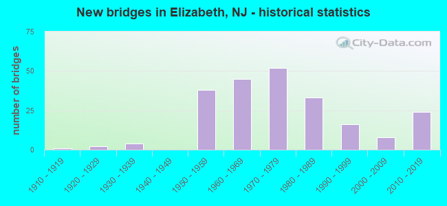
- New bridges - historical statistics
- 11910-1919
- 21920-1929
- 41930-1939
- 381950-1959
- 451960-1969
- 521970-1979
- 331980-1989
- 161990-1999
- 82000-2009
- 242010-2019

- Reconstructed bridges - Historical Statistics
- 11950-1959
- 01960-1969
- 11970-1979
- 311980-1989
- 181990-1999
- 132000-2009
- 22010-2019


- Bridge Condition - Deck
- 7.6%Excellent
- 2.5%Very good
- 61.3%Good
- 22.7%Satisfactory
- 3.4%Fair
- 2.5%Poor

- Bridge Condition - Superstructure
- 6.7%Excellent
- 3.4%Very good
- 29.4%Good
- 48.7%Satisfactory
- 10.1%Fair
- 1.7%Poor
- 0.8%Serious

- Bridge Condition - Substructure
- 6.7%Excellent
- 0.8%Very good
- 14.3%Good
- 52.1%Satisfactory
- 24.4%Fair
- 1.7%Poor

- Bridge Condition - Channel
- 11.1%Excellent
- 25.9%Very good
- 59.3%Good
- 3.7%Satisfactory
Find on map >> Show street view
Structure Number: 382304D, Location: 1.6 MI N of JCT 440-I278. (Lat: 40.634481, Lng: -74.145169), Route carried "on" structure: State highway 440, Year Built: 2018, Status: Open, Structure Length: 72.57m (238.09ft), Average Daily Traffic: 26,420 (year 2021), Truck Traffic: 4%, Average Future Daily Traffic: 32,232 (year 2041), Design Load: HL 93, Features Intersected: Innis Street
Minimum Vertical Clearance: 30.18m (99.02ft), Kilometerpoint: 0.000, Lanes on structure: 2, Lanes under structure: 5, Base Highway Network: Yes, Toll: Toll bridge, Owner: Local Agency, Approaching Roadway Width: 14.6m (47.9ft), Material/Design: Prestressed concrete continuous, Design/Construction: Segmental Box Girder, Number Of Spans In Main Unit: 12, Length of Maximum Span: 82.9m (272.0ft), Curb-To-Curb Width: 11.0m (36.1ft), Out-to-Out Width: 12.6m (41.3ft)
Condition: Deck: Very good, Superstructure: Good, Substructure: Very good, Operating Rating: 75.8 metric tons, Method Used To Determine Operating Rating: Load and Resistance Factor Rating (LRFR) rating reported by rating factor(RF) method using HL-93 loadings, Inventory Rating: 39.9 metric tons, Method Used To Determine Inventory Rating: Load and Resistance Factor Rating (LRFR) rating reported by rating factor(RF) method using HL-93 loadings, Structural Evaluation: Better than present minimum criteria, Deck Geometry: Somewhat better than minimum adequacy, Underclear: Equal to present desirable criteria, Approach Roadway Alignment: Superior to present desirable criteria, Designated Inspection Frequency: Every 24 months, Inspection Date: September 2021, Wearing Surface/Protective System: Wearing Surface: Monolithic Concrete
Find on map >> Show street view
Structure Number: 3823051, Location: Elizabeth, NJ (Lat: 40.634019, Lng: -74.194339), Route carried "on" structure: Interstate 278, Year Built: 2018, Status: Open, Structure Length: 60.50m (198.49ft), Average Daily Traffic: 36,189 (year 2020), Truck Traffic: 10%, Average Future Daily Traffic: 44,158 (year 2040), Design Load: HL 93, Features Intersected: Arthur Kill
Minimum Vertical Clearance: 30.18m (99.02ft), Kilometerpoint: 0.306, Lanes on structure: 3, Base Highway Network: Yes, Toll: Toll bridge, Owner: Local Toll Authority, Approaching Roadway Width: 16.2m (53.1ft), Navigation Control: Yes ( Vertical Clearance: 41.8m (137.1ft), Horizontal Clearance: 152.4m (500.0ft)), Material/Design: Steel continuous, Design/Construction: Stayed Girder, Number Of Spans In Main Unit: 3, Number Of Approach Spans: 2, Length of Maximum Span: 274.3m (899.9ft), Curb or Sidewalk Widths: Left: 0.0m, Right: 3.0m (9.8ft), Curb-To-Curb Width: 16.2m (53.1ft), Out-to-Out Width: 21.5m (70.5ft)
Condition: Deck: Excellent, Superstructure: Excellent, Substructure: Excellent, Channel: Excellent, Operating Rating: 46.3 metric tons, Method Used To Determine Operating Rating: Load and Resistance Factor Rating (LRFR) rating reported by rating factor(RF) method using HL-93 loadings, Inventory Rating: 35.6 metric tons, Method Used To Determine Inventory Rating: Load and Resistance Factor Rating (LRFR) rating reported by rating factor(RF) method using HL-93 loadings, Structural Evaluation: Superior to present desirable criteria, Deck Geometry: Equal to present minimum criteria, Waterway Adequacy: Superior to present desirable criteria, Approach Roadway Alignment: Equal to present desirable criteria, Designated Inspection Frequency: Every 24 months, Inspection Date: June 2020, Deck Structure Type: Concrete Precast Panels, Wearing Surface/Protective System: Wearing Surface: Latex Concrete, Membrane: Epoxy, Deck Protection: Epoxy Coated Reinforcing
Find on map >> Show street view
Structure Number: 3823052, Location: Elizabeth, NJ (Lat: 40.633811, Lng: -74.194531), Route carried "on" structure: Interstate 278, Year Built: 2017, Status: Open, Structure Length: 60.47m (198.39ft), Average Daily Traffic: 32,069 (year 2021), Truck Traffic: 9%, Average Future Daily Traffic: 38,483 (year 2041), Design Load: HL 93, Features Intersected: Arthur Kill
Minimum Vertical Clearance: 30.18m (99.02ft), Kilometerpoint: 0.306, Lanes on structure: 3, Base Highway Network: Yes, Toll: Toll bridge, Owner: Local Toll Authority, Approaching Roadway Width: 16.2m (53.1ft), Navigation Control: Yes ( Vertical Clearance: 41.8m (137.1ft), Horizontal Clearance: 152.4m (500.0ft)), Material/Design: Steel continuous, Design/Construction: Stayed Girder, Number Of Spans In Main Unit: 5, Length of Maximum Span: 274.3m (899.9ft), Curb-To-Curb Width: 16.2m (53.1ft), Out-to-Out Width: 17.1m (56.1ft)
Condition: Deck: Excellent, Superstructure: Excellent, Substructure: Excellent, Channel: Excellent, Operating Rating: 48.0 metric tons, Method Used To Determine Operating Rating: Load and Resistance Factor Rating (LRFR) rating reported by rating factor(RF) method using HL-93 loadings, Inventory Rating: 36.9 metric tons, Method Used To Determine Inventory Rating: Load and Resistance Factor Rating (LRFR) rating reported by rating factor(RF) method using HL-93 loadings, Structural Evaluation: Superior to present desirable criteria, Deck Geometry: Equal to present minimum criteria, Waterway Adequacy: Superior to present desirable criteria, Approach Roadway Alignment: Equal to present desirable criteria, Designated Inspection Frequency: Every 24 months, Underwater Inspection Frequency: Every 60 months, Inspection Date: August 2021, Underwater Inspection Date: August 2017, Deck Structure Type: Concrete Precast Panels, Wearing Surface/Protective System: Wearing Surface: Latex Concrete, Membrane: Epoxy, Deck Protection: Epoxy Coated Reinforcing
Find on map >> Show street view
Structure Number: 382305A, Location: Elizabeth, NJ (Lat: 40.633969, Lng: -74.194389), Route carried "on" structure: Interstate 278, Year Built: 2018, Status: Open, Structure Length: 84.86m (278.41ft), Average Daily Traffic: 72,379 (year 2020), Truck Traffic: 10%, Average Future Daily Traffic: 88,316 (year 2040), Design Load: HL 93, Features Intersected: Gulf Avenue
Minimum Vertical Clearance: 5.18m (16.99ft), Kilometerpoint: 0.595, Lanes on structure: 3, Lanes under structure: 2, Base Highway Network: Yes, Toll: Toll bridge, Owner: Local Toll Authority, Approaching Roadway Width: 16.2m (53.1ft), Material/Design: Prestressed concrete continuous, Design/Construction: Stringer/Multi-beam, Number Of Spans In Main Unit: 43, Length of Maximum Span: 53.3m (174.9ft), Curb or Sidewalk Widths: Left: 0.0m, Right: 3.0m (9.8ft), Curb-To-Curb Width: 16.2m (53.1ft), Out-to-Out Width: 17.1m (56.1ft)
Condition: Deck: Excellent, Superstructure: Excellent, Substructure: Excellent, Channel: Good, Operating Rating: 57.0 metric tons, Method Used To Determine Operating Rating: Load and Resistance Factor Rating (LRFR) rating reported by rating factor(RF) method using HL-93 loadings, Inventory Rating: 32.7 metric tons, Method Used To Determine Inventory Rating: Load and Resistance Factor Rating (LRFR) rating reported by rating factor(RF) method using HL-93 loadings, Structural Evaluation: Superior to present desirable criteria, Deck Geometry: Equal to present minimum criteria, Waterway Adequacy: Better than present minimum criteria, Approach Roadway Alignment: Equal to present desirable criteria, Designated Inspection Frequency: Every 24 months, Inspection Date: June 2020, Deck Structure Type: Concrete Precast Panels, Wearing Surface/Protective System: Wearing Surface: Latex Concrete, Membrane: Epoxy, Deck Protection: Epoxy Coated Reinforcing
Find on map >> Show street view
Structure Number: 382305B, Location: Elizabeth, NJ (Lat: 40.633811, Lng: -74.194519), Route carried "on" structure: Interstate 278, Year Built: 2017, Status: Open, Structure Length: 85.01m (278.90ft), Average Daily Traffic: 32,069 (year 2021), Truck Traffic: 9%, Average Future Daily Traffic: 38,483 (year 2041), Design Load: Greater than HL93, Features Intersected: Gulf Avenue
Minimum Vertical Clearance: 5.33m (17.49ft), Kilometerpoint: 0.000, Lanes on structure: 3, Lanes under structure: 2, Base Highway Network: Yes, Toll: Toll bridge, Owner: Local Toll Authority, Approaching Roadway Width: 16.2m (53.1ft), Material/Design: Prestressed concrete continuous, Design/Construction: Stringer/Multi-beam, Number Of Spans In Main Unit: 18, Length of Maximum Span: 53.3m (174.9ft), Curb-To-Curb Width: 16.2m (53.1ft), Out-to-Out Width: 17.1m (56.1ft)
Condition: Deck: Excellent, Superstructure: Excellent, Substructure: Excellent, Operating Rating: 47.3 metric tons, Method Used To Determine Operating Rating: Load and Resistance Factor Rating (LRFR) rating reported by rating factor(RF) method using HL-93 loadings, Inventory Rating: 36.6 metric tons, Method Used To Determine Inventory Rating: Load and Resistance Factor Rating (LRFR) rating reported by rating factor(RF) method using HL-93 loadings, Structural Evaluation: Superior to present desirable criteria, Deck Geometry: Equal to present minimum criteria, Approach Roadway Alignment: Equal to present desirable criteria, Designated Inspection Frequency: Every 24 months, Inspection Date: August 2021, Deck Structure Type: Concrete Precast Panels, Wearing Surface/Protective System: Wearing Surface: Latex Concrete, Membrane: Epoxy, Deck Protection: Epoxy Coated Reinforcing
Find on map >> Show street view
Structure Number: 382305C, Location: Elizabeth, NJ (Lat: 40.636919, Lng: -74.203900), Route carried "on" structure: Interstate 278, Year Built: 2017, Status: Open, Structure Length: 45.90m (150.59ft), Average Daily Traffic: 32,069 (year 2021), Truck Traffic: 9%, Average Future Daily Traffic: 38,483 (year 2041), Design Load: HL 93, Features Intersected: Amboy Avenue
Minimum Vertical Clearance: 5.33m (17.49ft), Kilometerpoint: 0.000, Lanes on structure: 3, Lanes under structure: 4, Base Highway Network: Yes, Toll: Toll bridge, Owner: Local Toll Authority, Approaching Roadway Width: 16.2m (53.1ft), Material/Design: Prestressed concrete continuous, Design/Construction: Stringer/Multi-beam, Number Of Spans In Main Unit: 9, Length of Maximum Span: 53.9m (176.8ft), Curb-To-Curb Width: 16.2m (53.1ft), Out-to-Out Width: 17.1m (56.1ft)
Condition: Deck: Excellent, Superstructure: Excellent, Substructure: Excellent, Operating Rating: 47.3 metric tons, Method Used To Determine Operating Rating: Load and Resistance Factor Rating (LRFR) rating reported by rating factor(RF) method using HL-93 loadings, Inventory Rating: 36.6 metric tons, Method Used To Determine Inventory Rating: Load and Resistance Factor Rating (LRFR) rating reported by rating factor(RF) method using HL-93 loadings, Structural Evaluation: Superior to present desirable criteria, Deck Geometry: Equal to present minimum criteria, Approach Roadway Alignment: Equal to present desirable criteria, Designated Inspection Frequency: Every 24 months, Inspection Date: August 2021, Deck Structure Type: Concrete Precast Panels, Wearing Surface/Protective System: Wearing Surface: Latex Concrete, Membrane: Epoxy, Deck Protection: Epoxy Coated Reinforcing
Find on map >> Show street view
Structure Number: 382305D, Location: Elizabeth, NJ (Lat: 40.637119, Lng: -74.200200), Route carried "on" structure: Interstate 278, Year Built: 2018, Status: Open, Structure Length: 57.67m (189.21ft), Average Daily Traffic: 72,379 (year 2020), Truck Traffic: 10%, Average Future Daily Traffic: 88,316 (year 2040), Design Load: HL 93, Features Intersected: Amboy Avenue
Minimum Vertical Clearance: 30+ m (98+ ft), Kilometerpoint: 0.000, Lanes on structure: 3, Lanes under structure: 4, Base Highway Network: Yes, Toll: Toll bridge, Owner: Local Toll Authority, Approaching Roadway Width: 16.2m (53.1ft), Material/Design: Prestressed concrete continuous, Design/Construction: Stringer/Multi-beam, Number Of Spans In Main Unit: 11, Length of Maximum Span: 53.9m (176.8ft), Curb or Sidewalk Widths: Left: 0.0m, Right: 3.0m (9.8ft), Curb-To-Curb Width: 16.2m (53.1ft), Out-to-Out Width: 17.1m (56.1ft)
Condition: Deck: Excellent, Superstructure: Excellent, Substructure: Excellent, Operating Rating: 48.6 metric tons, Method Used To Determine Operating Rating: Load and Resistance Factor Rating (LRFR) rating reported by rating factor(RF) method using HL-93 loadings, Inventory Rating: 37.6 metric tons, Method Used To Determine Inventory Rating: Load and Resistance Factor Rating (LRFR) rating reported by rating factor(RF) method using HL-93 loadings, Structural Evaluation: Superior to present desirable criteria, Deck Geometry: Equal to present minimum criteria, Underclear: Superior to present desirable criteria, Approach Roadway Alignment: Equal to present desirable criteria, Designated Inspection Frequency: Every 24 months, Inspection Date: June 2020, Deck Structure Type: Concrete Precast Panels, Wearing Surface/Protective System: Wearing Surface: Latex Concrete, Membrane: Epoxy, Deck Protection: Epoxy Coated Reinforcing
Find on map >> Show street view
Structure Number: I09935B, Location: .39 MI S ELIZABETH RIVER (Lat: 40.642461, Lng: -74.209256), Route carried "on" structure: Ramp Interstate 95, Year Built: 1965, Status: Open, Structure Length: 10.42m (34.19ft), Average Daily Traffic: 25,180 (year 2021), Truck Traffic: 5%, Average Future Daily Traffic: 30,725 (year 2041), Design Load: HS 20, Features Intersected: NJ TPK RAMPS TE,ET,CA, Facility Carried by Structure: NJ TPK INTER 13 TW
Minimum Vertical Clearance: 30+ m (98+ ft), Kilometerpoint: 86.969, Lanes on structure: 2, Lanes under structure: 6, Toll: On toll road, Owner: State Toll Authority, Approaching Roadway Width: 11.9m (39.0ft), Skew: 9 degrees, Material/Design: Steel, Design/Construction: Stringer/Multi-beam, Number Of Spans In Main Unit: 6, Length of Maximum Span: 18.6m (61.0ft), Curb or Sidewalk Widths: Left: 0.6m (2.0ft), Right: 0.6m (2.0ft), Curb-To-Curb Width: 11.9m (39.0ft), Out-to-Out Width: 13.7m (44.9ft)
Condition: Deck: Good, Superstructure: Satisfactory, Substructure: Satisfactory, Operating Rating: 41.1 metric tons, Method Used To Determine Operating Rating: Load and Resistance Factor Rating (LRFR) rating reported by rating factor(RF) method using HL-93 loadings, Inventory Rating: 31.8 metric tons, Method Used To Determine Inventory Rating: Load and Resistance Factor Rating (LRFR) rating reported by rating factor(RF) method using HL-93 loadings, Structural Evaluation: Equal to present minimum criteria, Deck Geometry: Superior to present desirable criteria, Underclear: High priority of corrective action, Approach Roadway Alignment: Equal to present minimum criteria, Designated Inspection Frequency: Every 24 months, Inspection Date: July 2021, Deck Structure Type: Concrete Cast-file-Place, Wearing Surface/Protective System: Wearing Surface: Bituminous, Membrane: Other
Find on map >> Show street view
Structure Number: I09935D, Location: .9 MI W GOETHALS BRIDGE (Lat: 40.642650, Lng: -74.212431), Route carried "on" structure: Ramp Interstate 95, Year Built: 1965, Year Reconstructed: 1987, Status: Open, Structure Length: 6.92m (22.70ft), Average Daily Traffic: 15,191 (year 2021), Truck Traffic: 10%, Average Future Daily Traffic: 18,536 (year 2041), Design Load: HS 20+Mod, Features Intersected: I-278 EB, Facility Carried by Structure: NJTA INT 13 RMP ET
Minimum Vertical Clearance: 30+ m (98+ ft), Kilometerpoint: 87.066, Lanes on structure: 2, Lanes under structure: 1, Toll: On toll road, Owner: State Toll Authority, Approaching Roadway Width: 14.0m (45.9ft), Skew: 9 degrees, Material/Design: Steel, Design/Construction: Stringer/Multi-beam, Number Of Spans In Main Unit: 5, Length of Maximum Span: 17.4m (57.1ft), Curb-To-Curb Width: 14.1m (46.3ft), Out-to-Out Width: 15.2m (49.9ft)
Condition: Deck: Satisfactory, Superstructure: Good, Substructure: Satisfactory, Operating Rating: 35.6 metric tons, Method Used To Determine Operating Rating: Load and Resistance Factor Rating (LRFR) rating reported by rating factor(RF) method using HL-93 loadings, Inventory Rating: 27.5 metric tons, Method Used To Determine Inventory Rating: Load and Resistance Factor Rating (LRFR) rating reported by rating factor(RF) method using HL-93 loadings, Structural Evaluation: Equal to present minimum criteria, Deck Geometry: Superior to present desirable criteria, Underclear: Meets minimum limits, Approach Roadway Alignment: Equal to present minimum criteria, Designated Inspection Frequency: Every 24 months, Inspection Date: July 2021, Deck Structure Type: Concrete Cast-file-Place, Wearing Surface/Protective System: Wearing Surface: Latex Concrete, Membrane: Other, Deck Protection: Epoxy Coated Reinforcing
Find on map >> Show street view
Structure Number: I10153B, Location: 3.21 MI S INT.14 (Lat: 40.665250, Lng: -74.183331), Route carried "on" structure: Ramp Interstate 95, Year Built: 1982, Status: Open, Structure Length: 1.13m (3.71ft), Average Daily Traffic: 5,275 (year 2021), Truck Traffic: 10%, Average Future Daily Traffic: 6,436 (year 2041), Design Load: HS 20, Features Intersected: MAINTENANCE ROAD, Facility Carried by Structure: NJ TPK INT 13A TSO
Minimum Vertical Clearance: 30+ m (98+ ft), Kilometerpoint: 90.381, Lanes on structure: 1, Lanes under structure: 1, Toll: On toll road, Owner: State Toll Authority, Approaching Roadway Width: 7.9m (25.9ft), Skew: 9 degrees, Material/Design: Concrete, Design/Construction: Slab, Number Of Spans In Main Unit: 1, Length of Maximum Span: 8.5m (27.9ft), Curb-To-Curb Width: 9.4m (30.8ft), Out-to-Out Width: 10.0m (32.8ft)
Condition: Deck: Good, Superstructure: Good, Substructure: Good, Operating Rating: 34.0 metric tons, Method Used To Determine Operating Rating: Load and Resistance Factor Rating (LRFR) rating reported by rating factor(RF) method using HL-93 loadings, Inventory Rating: 26.2 metric tons, Method Used To Determine Inventory Rating: Load and Resistance Factor Rating (LRFR) rating reported by rating factor(RF) method using HL-93 loadings, Structural Evaluation: Equal to present minimum criteria, Deck Geometry: Superior to present desirable criteria, Underclear: High priority of corrective action, Approach Roadway Alignment: Equal to present desirable criteria, Length Of Structure Improvement: 1.52m (4.99ft), Designated Inspection Frequency: Every 24 months, Inspection Date: June 2021, Bridge Improvement Cost: $375,000, Roadway Improvement Cost: $80,000, Total Project Cost: $650,000 ( Estimate for 2017), Deck Structure Type: Concrete Cast-file-Place, Wearing Surface/Protective System: Wearing Surface: Bituminous, Membrane: Other, Deck Protection: Epoxy Coated Reinforcing
Find on map >> Show street view
Structure Number: I10165B, Location: 3.09 MI S INT.14 (Lat: 40.671708, Lng: -74.185344), Route carried "on" structure: City street , Year Built: 1981, Status: Open, Structure Length: 10.82m (35.50ft), Average Daily Traffic: 17,930 (year 2021), Truck Traffic: 4%, Average Future Daily Traffic: 21,878 (year 2041), Design Load: HS 20, Features Intersected: NJ TPK 13A-WXT,TWX,&TWL, Facility Carried by Structure: NORTH AVE EB(624)
Minimum Vertical Clearance: 30+ m (98+ ft), Kilometerpoint: 2.269, Lanes on structure: 2, Lanes under structure: 6, Owner: State Toll Authority, Approaching Roadway Width: 11.6m (38.1ft), Material/Design: Steel, Design/Construction: Stringer/Multi-beam, Number Of Spans In Main Unit: 4, Length of Maximum Span: 28.7m (94.2ft), Curb-To-Curb Width: 11.6m (38.1ft), Out-to-Out Width: 12.7m (41.7ft)
Condition: Deck: Good, Superstructure: Good, Substructure: Good, Operating Rating: 49.6 metric tons, Method Used To Determine Operating Rating: Load and Resistance Factor Rating (LRFR) rating reported by rating factor(RF) method using HL-93 loadings, Inventory Rating: 38.2 metric tons, Method Used To Determine Inventory Rating: Load and Resistance Factor Rating (LRFR) rating reported by rating factor(RF) method using HL-93 loadings, Structural Evaluation: Better than present minimum criteria, Deck Geometry: Better than present minimum criteria, Underclear: Meets minimum limits, Approach Roadway Alignment: Equal to present minimum criteria, Designated Inspection Frequency: Every 24 months, Critical Feature Inspection Frequency: Every 24 months, Inspection Date: July 2021, Critical Feature Inspection Date: July 2021, Deck Structure Type: Concrete Cast-file-Place, Wearing Surface/Protective System: Wearing Surface: Monolithic Concrete
Find on map >> Show street view
Structure Number: M09935A, Location: .39 MI S ELIZABETH RIVER (Lat: 40.640186, Lng: -74.207569), Route carried "on" structure: Ramp Interstate 95, Year Built: 1965, Status: Open, Structure Length: 21.82m (71.59ft), Average Daily Traffic: 26,740 (year 2021), Truck Traffic: 13%, Average Future Daily Traffic: 32,624 (year 2041), Design Load: HS 20, Features Intersected: NJ TPK RWYS & RAMP ST, Facility Carried by Structure: NJ TPK INTER 13 TN
Minimum Vertical Clearance: 30+ m (98+ ft), Kilometerpoint: 86.969, Lanes on structure: 2, Lanes under structure: 14, Toll: On toll road, Owner: State Toll Authority, Approaching Roadway Width: 11.0m (36.1ft), Skew: 9 degrees, Material/Design: Steel, Design/Construction: Stringer/Multi-beam, Number Of Spans In Main Unit: 11, Length of Maximum Span: 23.2m (76.1ft), Curb or Sidewalk Widths: Left: 0.6m (2.0ft), Right: 0.6m (2.0ft), Curb-To-Curb Width: 11.0m (36.1ft), Out-to-Out Width: 12.8m (42.0ft)
Condition: Deck: Satisfactory, Superstructure: Satisfactory, Substructure: Fair, Operating Rating: 27.9 metric tons, Method Used To Determine Operating Rating: Load and Resistance Factor Rating (LRFR) rating reported by rating factor(RF) method using HL-93 loadings, Inventory Rating: 21.4 metric tons, Method Used To Determine Inventory Rating: Load and Resistance Factor Rating (LRFR) rating reported by rating factor(RF) method using HL-93 loadings, Structural Evaluation: Somewhat better than minimum adequacy, Deck Geometry: Better than present minimum criteria, Underclear: Meets minimum limits, Approach Roadway Alignment: Equal to present desirable criteria, Designated Inspection Frequency: Every 24 months, Critical Feature Inspection Frequency: Every 24 months, Inspection Date: July 2021, Critical Feature Inspection Date: July 2021, Deck Structure Type: Concrete Cast-file-Place, Wearing Surface/Protective System: Wearing Surface: Bituminous, Membrane: Other
Find on map >> Show street view
Structure Number: M09951, Location: .25 MI S ELIZABETH RIVER (Lat: 40.642781, Lng: -74.206025), Route carried "on" structure: City street , Year Built: 1950, Year Reconstructed: 2003, Status: Open, Structure Length: 20.73m (68.01ft), Average Daily Traffic: 129,435 (year 2021), Truck Traffic: 17%, Average Future Daily Traffic: 157,910 (year 2041), Design Load: HS 20, Features Intersected: NJTPK RWYS & RAMPS NT&TN, Facility Carried by Structure: RELOC.BAYWAY AVE.
Minimum Vertical Clearance: 30+ m (98+ ft), Kilometerpoint: 0.000, Lanes on structure: 2, Lanes under structure: 16, Owner: State Toll Authority, Approaching Roadway Width: 12.2m (40.0ft), Skew: 2 degrees, Material/Design: Steel, Design/Construction: Stringer/Multi-beam, Number Of Spans In Main Unit: 11, Length of Maximum Span: 33.8m (110.9ft), Curb or Sidewalk Widths: Left: 1.8m (5.9ft), Right: 1.8m (5.9ft), Curb-To-Curb Width: 12.2m (40.0ft), Out-to-Out Width: 16.5m (54.1ft)
Condition: Deck: Satisfactory, Superstructure: Satisfactory, Substructure: Satisfactory, Operating Rating: 42.4 metric tons, Method Used To Determine Operating Rating: Load and Resistance Factor Rating (LRFR) rating reported by rating factor(RF) method using HL-93 loadings, Inventory Rating: 32.7 metric tons, Method Used To Determine Inventory Rating: Load and Resistance Factor Rating (LRFR) rating reported by rating factor(RF) method using HL-93 loadings, Structural Evaluation: Equal to present minimum criteria, Deck Geometry: Somewhat better than minimum adequacy, Underclear: High priority of corrective action, Approach Roadway Alignment: Equal to present desirable criteria, Designated Inspection Frequency: Every 24 months, Inspection Date: May 2021, Deck Structure Type: Concrete Cast-file-Place, Wearing Surface/Protective System: Wearing Surface: Bituminous, Membrane: Other
Find on map >> Show street view
Structure Number: M09967, Location: .2 MI S INTERCHANGE 13 (Lat: 40.643803, Lng: -74.205369), Route carried "on" structure: Ramp Interstate 95, Year Built: 1970, Status: Open, Structure Length: 6.92m (22.70ft), Average Daily Traffic: 25,388 (year 2021), Truck Traffic: 15%, Average Future Daily Traffic: 30,973 (year 2041), Design Load: HS 20, Features Intersected: INFIELDS, Facility Carried by Structure: NJTPK INT13 RP NT
Minimum Vertical Clearance: 30+ m (98+ ft), Kilometerpoint: 87.500, Lanes on structure: 2, Toll: On toll road, Owner: State Toll Authority, Approaching Roadway Width: 11.0m (36.1ft), Material/Design: Steel, Design/Construction: Stringer/Multi-beam, Number Of Spans In Main Unit: 3, Length of Maximum Span: 22.6m (74.1ft), Curb or Sidewalk Widths: Left: 0.6m (2.0ft), Right: 0.6m (2.0ft), Curb-To-Curb Width: 11.0m (36.1ft), Out-to-Out Width: 12.8m (42.0ft)
Condition: Deck: Good, Superstructure: Satisfactory, Substructure: Fair, Operating Rating: 62.9 metric tons, Method Used To Determine Operating Rating: Load and Resistance Factor Rating (LRFR) rating reported by rating factor(RF) method using HL-93 loadings, Inventory Rating: 48.3 metric tons, Method Used To Determine Inventory Rating: Load and Resistance Factor Rating (LRFR) rating reported by rating factor(RF) method using HL-93 loadings, Structural Evaluation: Somewhat better than minimum adequacy, Deck Geometry: Better than present minimum criteria, Approach Roadway Alignment: Equal to present desirable criteria, Designated Inspection Frequency: Every 24 months, Critical Feature Inspection Frequency: Every 24 months, Inspection Date: August 2021, Critical Feature Inspection Date: August 2021, Deck Structure Type: Concrete Cast-file-Place, Wearing Surface/Protective System: Wearing Surface: Bituminous, Membrane: Other
Find on map >> Show street view
Structure Number: M09967A, Location: 2 MI S INTERCHANGE 13 (Lat: 40.644347, Lng: -74.204961), Route carried "on" structure: Ramp Interstate 95, Year Built: 1970, Year Reconstructed: 1991, Status: Open, Structure Length: 22.77m (74.70ft), Average Daily Traffic: 13,006 (year 2021), Truck Traffic: 5%, Average Future Daily Traffic: 15,870 (year 2041), Design Load: HS 20, Features Intersected: NJTPK NSO,ELIZABETH RIV, Facility Carried by Structure: NJTPK INT13 RP NIT
Minimum Vertical Clearance: 30+ m (98+ ft), Kilometerpoint: 87.516, Lanes on structure: 1, Lanes under structure: 3, Toll: On toll road, Owner: State Toll Authority, Approaching Roadway Width: 7.9m (25.9ft), Skew: 1 degrees, Navigation Control: Yes ( Vertical Clearance: 9.1m (29.9ft), Horizontal Clearance: 18.3m (60.0ft)), Material/Design: Steel, Design/Construction: Stringer/Multi-beam, Number Of Spans In Main Unit: 10, Length of Maximum Span: 24.4m (80.1ft), Curb or Sidewalk Widths: Left: 0.6m (2.0ft), Right: 0.6m (2.0ft), Curb-To-Curb Width: 7.3m (24.0ft), Out-to-Out Width: 9.1m (29.9ft)
Condition: Deck: Good, Superstructure: Satisfactory, Substructure: Fair, Channel: Good, Operating Rating: 26.6 metric tons, Method Used To Determine Operating Rating: Load and Resistance Factor Rating (LRFR) rating reported by rating factor(RF) method using HL-93 loadings, Inventory Rating: 20.7 metric tons, Method Used To Determine Inventory Rating: Load and Resistance Factor Rating (LRFR) rating reported by rating factor(RF) method using HL-93 loadings, Structural Evaluation: Somewhat better than minimum adequacy, Deck Geometry: Better than present minimum criteria, Underclear: Meets minimum limits, Waterway Adequacy: Better than present minimum criteria, Approach Roadway Alignment: Better than present minimum criteria, Designated Inspection Frequency: Every 24 months, Critical Feature Inspection Frequency: Every 24 months, Underwater Inspection Frequency: Every 48 months, Inspection Date: July 2021, Critical Feature Inspection Date: July 2021, Underwater Inspection Date: April 2021, Deck Structure Type: Concrete Cast-file-Place, Wearing Surface/Protective System: Wearing Surface: Bituminous, Membrane: Other
Find on map >> Show street view
Structure Number: M0997, Location: .15 MI S INTERCHANGE 13 (Lat: 40.642997, Lng: -74.204381), Route carried "on" structure: Ramp Interstate 95, Year Built: 1970, Status: Open, Structure Length: 16.37m (53.71ft), Average Daily Traffic: 29,879 (year 2021), Truck Traffic: 10%, Average Future Daily Traffic: 36,458 (year 2041), Design Load: HS 20, Features Intersected: INFIELDS, Facility Carried by Structure: NJTPK INT13 RP TN
Minimum Vertical Clearance: 30+ m (98+ ft), Kilometerpoint: 87.500, Lanes on structure: 2, Lanes under structure: 2, Toll: On toll road, Owner: State Toll Authority, Approaching Roadway Width: 11.0m (36.1ft), Material/Design: Steel, Design/Construction: Stringer/Multi-beam, Number Of Spans In Main Unit: 7, Length of Maximum Span: 25.6m (84.0ft), Curb or Sidewalk Widths: Left: 0.6m (2.0ft), Right: 0.6m (2.0ft), Curb-To-Curb Width: 11.0m (36.1ft), Out-to-Out Width: 12.8m (42.0ft)
Condition: Deck: Good, Superstructure: Satisfactory, Substructure: Satisfactory, Operating Rating: 55.7 metric tons, Method Used To Determine Operating Rating: Load and Resistance Factor Rating (LRFR) rating reported by rating factor(RF) method using HL-93 loadings, Inventory Rating: 43.1 metric tons, Method Used To Determine Inventory Rating: Load and Resistance Factor Rating (LRFR) rating reported by rating factor(RF) method using HL-93 loadings, Structural Evaluation: Equal to present minimum criteria, Deck Geometry: Better than present minimum criteria, Approach Roadway Alignment: Equal to present desirable criteria, Designated Inspection Frequency: Every 24 months, Critical Feature Inspection Frequency: Every 24 months, Inspection Date: July 2021, Critical Feature Inspection Date: July 2021, Deck Structure Type: Concrete Cast-file-Place, Wearing Surface/Protective System: Wearing Surface: Bituminous, Membrane: Other
Find on map >> Show street view
Structure Number: M09970A, Location: .15 MI S INTERCHANGE 13 (Lat: 40.644350, Lng: -74.203675), Route carried "on" structure: Ramp Interstate 95, Year Built: 1970, Status: Open, Structure Length: 17.59m (57.71ft), Average Daily Traffic: 13,787 (year 2021), Truck Traffic: 5%, Average Future Daily Traffic: 16,822 (year 2041), Design Load: HS 20, Features Intersected: NJTPK SNO-ELIZABETH RIV., Facility Carried by Structure: NJTPK INT13 RP TNI
Minimum Vertical Clearance: 30+ m (98+ ft), Kilometerpoint: 87.500, Lanes on structure: 1, Lanes under structure: 3, Toll: On toll road, Owner: State Toll Authority, Approaching Roadway Width: 7.3m (24.0ft), Skew: 1 degrees, Navigation Control: Yes ( Vertical Clearance: 9.4m (30.8ft), Horizontal Clearance: 18.3m (60.0ft)), Material/Design: Steel, Design/Construction: Stringer/Multi-beam, Number Of Spans In Main Unit: 8, Length of Maximum Span: 25.3m (83.0ft), Curb or Sidewalk Widths: Left: 0.6m (2.0ft), Right: 0.6m (2.0ft), Curb-To-Curb Width: 7.3m (24.0ft), Out-to-Out Width: 9.1m (29.9ft)
Condition: Deck: Good, Superstructure: Satisfactory, Substructure: Fair, Channel: Good, Operating Rating: 25.9 metric tons, Method Used To Determine Operating Rating: Load and Resistance Factor Rating (LRFR) rating reported by rating factor(RF) method using HL-93 loadings, Inventory Rating: 20.1 metric tons, Method Used To Determine Inventory Rating: Load and Resistance Factor Rating (LRFR) rating reported by rating factor(RF) method using HL-93 loadings, Structural Evaluation: Somewhat better than minimum adequacy, Deck Geometry: Better than present minimum criteria, Underclear: Meets minimum limits, Waterway Adequacy: Better than present minimum criteria, Approach Roadway Alignment: Equal to present desirable criteria, Length Of Structure Improvement: 17.59m (57.71ft), Designated Inspection Frequency: Every 24 months, Critical Feature Inspection Frequency: Every 24 months, Underwater Inspection Frequency: Every 48 months, Inspection Date: July 2021, Critical Feature Inspection Date: July 2021, Underwater Inspection Date: April 2021, Deck Structure Type: Concrete Cast-file-Place, Wearing Surface/Protective System: Wearing Surface: Bituminous, Membrane: Other
Find on map >> Show street view
Structure Number: M09975, Location: .15 MI S INTERCHANGE 13 (Lat: 40.645089, Lng: -74.203611), Route carried "on" structure: Interstate 95, Year Built: 1950, Year Reconstructed: 2006, Status: Open, Structure Length: 9.63m (31.59ft), Average Daily Traffic: 133,280 (year 2021), Truck Traffic: 10%, Average Future Daily Traffic: 159,940 (year 2039), Design Load: HS 20, Features Intersected: ELIZABETH RIVER, Facility Carried by Structure: NJTPK NSI&SNI RWY
Minimum Vertical Clearance: 30+ m (98+ ft), Kilometerpoint: 87.581, Lanes on structure: 6, Base Highway Network: Yes, Toll: On toll road, Owner: State Toll Authority, Approaching Roadway Width: 34.1m (111.9ft), Skew: 31 degrees, Navigation Control: Yes ( Vertical Clearance: 6.1m (20.0ft), Horizontal Clearance: 22.9m (75.1ft)), Material/Design: Steel, Design/Construction: Stringer/Multi-beam, Number Of Spans In Main Unit: 4, Length of Maximum Span: 24.4m (80.1ft), Curb-To-Curb Width: 33.5m (109.9ft), Out-to-Out Width: 35.4m (116.1ft)
Condition: Deck: Good, Superstructure: Fair, Substructure: Fair, Channel: Very good, Operating Rating: 45.7 metric tons, Method Used To Determine Operating Rating: Load and Resistance Factor Rating (LRFR) rating reported by rating factor(RF) method using HL-93 loadings, Inventory Rating: 35.3 metric tons, Method Used To Determine Inventory Rating: Load and Resistance Factor Rating (LRFR) rating reported by rating factor(RF) method using HL-93 loadings, Structural Evaluation: Somewhat better than minimum adequacy, Deck Geometry: Superior to present desirable criteria, Waterway Adequacy: Equal to present desirable criteria, Approach Roadway Alignment: Equal to present desirable criteria, Designated Inspection Frequency: Every 24 months, Underwater Inspection Frequency: Every 48 months, Inspection Date: May 2021, Underwater Inspection Date: April 2021, Deck Structure Type: Concrete Cast-file-Place, Wearing Surface/Protective System: Wearing Surface: Monolithic Concrete, Deck Protection: Epoxy Coated Reinforcing
Find on map >> Show street view
Structure Number: M09975N, Location: .15 MI S INTERCHANGE 13 (Lat: 40.645017, Lng: -74.203386), Route carried "on" structure: Interstate 95, Year Built: 1967, Status: Open, Structure Length: 6.80m (22.31ft), Average Daily Traffic: 63,460 (year 2021), Truck Traffic: 29%, Average Future Daily Traffic: 76,150 (year 2041), Design Load: HS 20, Features Intersected: ELIZABETH RIVER, Facility Carried by Structure: TURNPIKE SNO
Minimum Vertical Clearance: 30+ m (98+ ft), Kilometerpoint: 87.516, Lanes on structure: 3, Base Highway Network: Yes, Toll: On toll road, Owner: State Toll Authority, Approaching Roadway Width: 16.2m (53.1ft), Navigation Control: Yes ( Vertical Clearance: 3.7m (12.1ft), Horizontal Clearance: 18.3m (60.0ft)), Material/Design: Steel, Design/Construction: Stringer/Multi-beam, Number Of Spans In Main Unit: 3, Length of Maximum Span: 24.4m (80.1ft), Curb-To-Curb Width: 16.2m (53.1ft), Out-to-Out Width: 18.0m (59.1ft)
Condition: Deck: Good, Superstructure: Satisfactory, Substructure: Fair, Channel: Good, Operating Rating: 75.8 metric tons, Method Used To Determine Operating Rating: Load and Resistance Factor Rating (LRFR) rating reported by rating factor(RF) method using HL-93 loadings, Inventory Rating: 58.3 metric tons, Method Used To Determine Inventory Rating: Load and Resistance Factor Rating (LRFR) rating reported by rating factor(RF) method using HL-93 loadings, Structural Evaluation: Somewhat better than minimum adequacy, Deck Geometry: Equal to present minimum criteria, Waterway Adequacy: Better than present minimum criteria, Approach Roadway Alignment: Equal to present desirable criteria, Designated Inspection Frequency: Every 24 months, Underwater Inspection Frequency: Every 48 months, Inspection Date: April 2021, Underwater Inspection Date: April 2021, Deck Structure Type: Concrete Cast-file-Place, Wearing Surface/Protective System: Wearing Surface: Bituminous, Membrane: Other
Find on map >> Show street view
Structure Number: M09975S, Location: .15 MI S ELIZABETH RIVER (Lat: 40.645483, Lng: -74.204261), Route carried "on" structure: Interstate 95, Year Built: 1970, Year Reconstructed: 1993, Status: Open, Structure Length: 9.30m (30.51ft), Average Daily Traffic: 63,460 (year 2021), Truck Traffic: 29%, Average Future Daily Traffic: 76,150 (year 2041), Design Load: HS 20, Features Intersected: ELIZABETH RIVER, Facility Carried by Structure: NJ TPK NSO RWY
Minimum Vertical Clearance: 30+ m (98+ ft), Kilometerpoint: 87.581, Lanes on structure: 4, Base Highway Network: Yes, Toll: On toll road, Owner: State Toll Authority, Approaching Roadway Width: 16.8m (55.1ft), Skew: 2 degrees, Navigation Control: Yes ( Vertical Clearance: 5.2m (17.1ft), Horizontal Clearance: 18.3m (60.0ft)), Material/Design: Steel, Design/Construction: Stringer/Multi-beam, Number Of Spans In Main Unit: 4, Length of Maximum Span: 26.8m (87.9ft), Curb-To-Curb Width: 18.9m (62.0ft), Out-to-Out Width: 20.4m (66.9ft)
Condition: Deck: Good, Superstructure: Satisfactory, Substructure: Fair, Channel: Good, Operating Rating: 72.3 metric tons, Method Used To Determine Operating Rating: Load and Resistance Factor Rating (LRFR) rating reported by rating factor(RF) method using HL-93 loadings, Inventory Rating: 55.7 metric tons, Method Used To Determine Inventory Rating: Load and Resistance Factor Rating (LRFR) rating reported by rating factor(RF) method using HL-93 loadings, Structural Evaluation: Somewhat better than minimum adequacy, Deck Geometry: Meets minimum limits, Waterway Adequacy: Better than present minimum criteria, Approach Roadway Alignment: Equal to present desirable criteria, Designated Inspection Frequency: Every 24 months, Underwater Inspection Frequency: Every 48 months, Inspection Date: April 2021, Underwater Inspection Date: April 2021, Deck Structure Type: Concrete Cast-file-Place, Wearing Surface/Protective System: Wearing Surface: Bituminous, Membrane: Other
Find on map >> Show street view
Structure Number: M10005, Location: .3 MI N ELIZABETH RIVER (Lat: 40.650000, Lng: -74.205000), Route carried "on" structure: Interstate 95, Year Built: 1950, Year Reconstructed: 2006, Status: Open, Structure Length: 4.39m (14.40ft), Average Daily Traffic: 142,336 (year 2021), Truck Traffic: 10%, Average Future Daily Traffic: 173,676 (year 2041), Design Load: HS 20, Features Intersected: THIRD AVENUE, Facility Carried by Structure: Turnpike NSI/SNI
Minimum Vertical Clearance: 30+ m (98+ ft), Kilometerpoint: 88.047, Lanes on structure: 6, Lanes under structure: 2, Base Highway Network: Yes, Toll: On toll road, Owner: State Toll Authority, Approaching Roadway Width: 38.6m (126.6ft), Skew: 31 degrees, Material/Design: Steel, Design/Construction: Stringer/Multi-beam, Number Of Spans In Main Unit: 3, Length of Maximum Span: 20.1m (65.9ft), Curb-To-Curb Width: 38.6m (126.6ft), Out-to-Out Width: 40.8m (133.9ft)
Condition: Deck: Good, Superstructure: Good, Substructure: Fair, Operating Rating: 49.6 metric tons, Method Used To Determine Operating Rating: Load and Resistance Factor Rating (LRFR) rating reported by rating factor(RF) method using HL-93 loadings, Inventory Rating: 37.9 metric tons, Method Used To Determine Inventory Rating: Load and Resistance Factor Rating (LRFR) rating reported by rating factor(RF) method using HL-93 loadings, Structural Evaluation: Somewhat better than minimum adequacy, Deck Geometry: Superior to present desirable criteria, Underclear: Better than present minimum criteria, Approach Roadway Alignment: Equal to present desirable criteria, Designated Inspection Frequency: Every 24 months, Inspection Date: March 2021, Deck Structure Type: Concrete Cast-file-Place, Wearing Surface/Protective System: Wearing Surface: Latex Concrete, Membrane: Other, Deck Protection: Epoxy Coated Reinforcing
Find on map >> Show street view
Structure Number: M10005N, Location: .3 MI N ELIZABETH RIVER (Lat: 40.650000, Lng: -74.201667), Route carried "on" structure: Interstate 95, Year Built: 1968, Year Reconstructed: 1991, Status: Open, Structure Length: 4.82m (15.81ft), Average Daily Traffic: 67,612 (year 2021), Truck Traffic: 30%, Average Future Daily Traffic: 82,500 (year 2041), Design Load: HS 20, Features Intersected: THIRD AVENUE, Facility Carried by Structure: Turnpike SNO
Minimum Vertical Clearance: 30+ m (98+ ft), Kilometerpoint: 88.047, Lanes on structure: 4, Lanes under structure: 2, Base Highway Network: Yes, Toll: On toll road, Owner: State Toll Authority, Approaching Roadway Width: 22.9m (75.1ft), Skew: 1 degrees, Material/Design: Steel, Design/Construction: Stringer/Multi-beam, Number Of Spans In Main Unit: 3, Length of Maximum Span: 22.3m (73.2ft), Curb-To-Curb Width: 22.9m (75.1ft), Out-to-Out Width: 24.3m (79.7ft)
Condition: Deck: Good, Superstructure: Satisfactory, Substructure: Satisfactory, Operating Rating: 43.4 metric tons, Method Used To Determine Operating Rating: Load and Resistance Factor Rating (LRFR) rating reported by rating factor(RF) method using HL-93 loadings, Inventory Rating: 33.4 metric tons, Method Used To Determine Inventory Rating: Load and Resistance Factor Rating (LRFR) rating reported by rating factor(RF) method using HL-93 loadings, Structural Evaluation: Equal to present minimum criteria, Deck Geometry: Superior to present desirable criteria, Underclear: Better than present minimum criteria, Approach Roadway Alignment: Equal to present desirable criteria, Designated Inspection Frequency: Every 24 months, Inspection Date: March 2021, Deck Structure Type: Concrete Cast-file-Place, Wearing Surface/Protective System: Wearing Surface: Bituminous, Membrane: Other
Find on map >> Show street view
Structure Number: M10005S, Location: .3 MI N ELIZABETH RIVER (Lat: 40.649317, Lng: -74.201011), Route carried "on" structure: Interstate 95, Year Built: 1970, Year Reconstructed: 1993, Status: Open, Structure Length: 4.33m (14.21ft), Average Daily Traffic: 67,612 (year 2021), Truck Traffic: 30%, Average Future Daily Traffic: 82,500 (year 2041), Design Load: HS 20, Features Intersected: THIRD AVENUE, Facility Carried by Structure: Turnpike NSO
Minimum Vertical Clearance: 30+ m (98+ ft), Kilometerpoint: 88.047, Lanes on structure: 4, Lanes under structure: 2, Base Highway Network: Yes, Toll: On toll road, Owner: State Toll Authority, Approaching Roadway Width: 18.3m (60.0ft), Skew: 1 degrees, Material/Design: Steel, Design/Construction: Stringer/Multi-beam, Number Of Spans In Main Unit: 3, Length of Maximum Span: 20.7m (67.9ft), Curb-To-Curb Width: 18.7m (61.4ft), Out-to-Out Width: 19.8m (65.0ft)
Condition: Deck: Good, Superstructure: Fair, Substructure: Satisfactory, Operating Rating: 65.1 metric tons, Method Used To Determine Operating Rating: Load and Resistance Factor Rating (LRFR) rating reported by rating factor(RF) method using HL-93 loadings, Inventory Rating: 50.2 metric tons, Method Used To Determine Inventory Rating: Load and Resistance Factor Rating (LRFR) rating reported by rating factor(RF) method using HL-93 loadings, Structural Evaluation: Somewhat better than minimum adequacy, Deck Geometry: Meets minimum limits, Underclear: Equal to present desirable criteria, Approach Roadway Alignment: Equal to present desirable criteria, Designated Inspection Frequency: Every 24 months, Inspection Date: March 2021, Deck Structure Type: Concrete Cast-file-Place, Wearing Surface/Protective System: Wearing Surface: Bituminous, Membrane: Other
Find on map >> Show street view
Structure Number: M10015, Location: .4 MI N ELIZABETH RIVER (Lat: 40.650083, Lng: -74.199211), Route carried "on" structure: Interstate 95, Year Built: 1951, Year Reconstructed: 2006, Status: Open, Structure Length: 3.93m (12.89ft), Average Daily Traffic: 142,336 (year 2021), Truck Traffic: 10%, Average Future Daily Traffic: 173,676 (year 2041), Design Load: HS 20, Features Intersected: SECOND AVENUE, Facility Carried by Structure: NJTPK NSI&SNI RWYS
Minimum Vertical Clearance: 30+ m (98+ ft), Kilometerpoint: 88.208, Lanes on structure: 6, Lanes under structure: 2, Base Highway Network: Yes, Toll: On toll road, Owner: State Toll Authority, Approaching Roadway Width: 30.1m (98.8ft), Skew: 30 degrees, Material/Design: Steel, Design/Construction: Stringer/Multi-beam, Number Of Spans In Main Unit: 3, Length of Maximum Span: 19.2m (63.0ft), Curb-To-Curb Width: 30.1m (98.8ft), Out-to-Out Width: 32.1m (105.3ft)
Condition: Deck: Good, Superstructure: Good, Substructure: Fair, Operating Rating: 47.6 metric tons, Method Used To Determine Operating Rating: Load and Resistance Factor Rating (LRFR) rating reported by rating factor(RF) method using HL-93 loadings, Inventory Rating: 36.6 metric tons, Method Used To Determine Inventory Rating: Load and Resistance Factor Rating (LRFR) rating reported by rating factor(RF) method using HL-93 loadings, Structural Evaluation: Somewhat better than minimum adequacy, Deck Geometry: Superior to present desirable criteria, Underclear: Equal to present minimum criteria, Approach Roadway Alignment: Equal to present desirable criteria, Designated Inspection Frequency: Every 24 months, Inspection Date: April 2021, Deck Structure Type: Concrete Cast-file-Place, Wearing Surface/Protective System: Membrane: Other, Deck Protection: Epoxy Coated Reinforcing
Find on map >> Show street view
Structure Number: M10015N, Location: .4 MI N ELIZABETH RIVER (Lat: 40.650000, Lng: -74.200000), Route carried "on" structure: Interstate 95, Year Built: 1970, Status: Open, Structure Length: 4.02m (13.19ft), Average Daily Traffic: 68,969 (year 2021), Truck Traffic: 30%, Average Future Daily Traffic: 84,155 (year 2041), Design Load: HS 20, Features Intersected: SECOND AVENUE, Facility Carried by Structure: NJ TPK SNO RWY
Minimum Vertical Clearance: 30+ m (98+ ft), Kilometerpoint: 88.208, Lanes on structure: 4, Lanes under structure: 2, Base Highway Network: Yes, Toll: On toll road, Owner: State Toll Authority, Approaching Roadway Width: 17.3m (56.8ft), Material/Design: Steel, Design/Construction: Stringer/Multi-beam, Number Of Spans In Main Unit: 3, Length of Maximum Span: 18.9m (62.0ft), Curb-To-Curb Width: 17.3m (56.8ft), Out-to-Out Width: 18.4m (60.4ft)
Condition: Deck: Satisfactory, Superstructure: Fair, Substructure: Fair, Operating Rating: 68.4 metric tons, Method Used To Determine Operating Rating: Load and Resistance Factor Rating (LRFR) rating reported by rating factor(RF) method using HL-93 loadings, Inventory Rating: 52.5 metric tons, Method Used To Determine Inventory Rating: Load and Resistance Factor Rating (LRFR) rating reported by rating factor(RF) method using HL-93 loadings, Structural Evaluation: Somewhat better than minimum adequacy, Deck Geometry: Meets minimum limits, Underclear: Somewhat better than minimum adequacy, Approach Roadway Alignment: Equal to present desirable criteria, Length Of Structure Improvement: 4.02m (13.19ft), Designated Inspection Frequency: Every 24 months, Inspection Date: April 2021, Bridge Improvement Cost: $200,000, Roadway Improvement Cost: $50,000, Total Project Cost: $300,000 ( Estimate for 2015), Deck Structure Type: Concrete Cast-file-Place, Wearing Surface/Protective System: Wearing Surface: Bituminous, Membrane: Other
Find on map >> Show street view
Structure Number: M10015S, Location: .4 MI N ELIZABETH RIVER (Lat: 40.650333, Lng: -74.199444), Route carried "on" structure: Interstate 95, Year Built: 1970, Year Reconstructed: 1991, Status: Open, Structure Length: 3.99m (13.09ft), Average Daily Traffic: 67,607 (year 2021), Truck Traffic: 30%, Average Future Daily Traffic: 82,494 (year 2041), Design Load: HS 20, Features Intersected: SECOND AVENUE, Facility Carried by Structure: NJ TPK NSO RWY
Minimum Vertical Clearance: 30+ m (98+ ft), Kilometerpoint: 88.208, Lanes on structure: 4, Lanes under structure: 2, Base Highway Network: Yes, Owner: State Toll Authority, Approaching Roadway Width: 18.9m (62.0ft), Material/Design: Steel, Design/Construction: Stringer/Multi-beam, Number Of Spans In Main Unit: 3, Length of Maximum Span: 18.9m (62.0ft), Curb-To-Curb Width: 18.9m (62.0ft), Out-to-Out Width: 20.1m (65.9ft)
Condition: Deck: Satisfactory, Superstructure: Satisfactory, Substructure: Satisfactory, Operating Rating: 68.4 metric tons, Method Used To Determine Operating Rating: Load and Resistance Factor Rating (LRFR) rating reported by rating factor(RF) method using HL-93 loadings, Inventory Rating: 52.5 metric tons, Method Used To Determine Inventory Rating: Load and Resistance Factor Rating (LRFR) rating reported by rating factor(RF) method using HL-93 loadings, Structural Evaluation: Equal to present minimum criteria, Deck Geometry: Meets minimum limits, Underclear: Better than present minimum criteria, Approach Roadway Alignment: Equal to present desirable criteria, Length Of Structure Improvement: 3.99m (13.09ft), Designated Inspection Frequency: Every 24 months, Inspection Date: April 2021, Bridge Improvement Cost: $200,000, Roadway Improvement Cost: $50,000, Total Project Cost: $300,000 ( Estimate for 2017), Deck Structure Type: Concrete Cast-file-Place, Wearing Surface/Protective System: Wearing Surface: Bituminous, Membrane: Other
Find on map >> Show street view
Structure Number: M10029, Location: .54 MI N ELIZABETH RIVER (Lat: 40.651667, Lng: -74.198333), Route carried "on" structure: Interstate 95, Year Built: 1950, Year Reconstructed: 2001, Status: Open, Structure Length: 4.48m (14.70ft), Average Daily Traffic: 142,336 (year 2021), Truck Traffic: 10%, Average Future Daily Traffic: 173,676 (year 2041), Design Load: HS 20, Features Intersected: FIRST AVENUE, Facility Carried by Structure: NJTPK NSI&SNI RWYS
Minimum Vertical Clearance: 30+ m (98+ ft), Kilometerpoint: 88.417, Lanes on structure: 6, Lanes under structure: 2, Base Highway Network: Yes, Toll: On toll road, Owner: State Toll Authority, Approaching Roadway Width: 28.7m (94.2ft), Skew: 30 degrees, Material/Design: Steel, Design/Construction: Stringer/Multi-beam, Number Of Spans In Main Unit: 3, Length of Maximum Span: 23.5m (77.1ft), Curb-To-Curb Width: 28.7m (94.2ft), Out-to-Out Width: 31.1m (102.0ft)
Condition: Deck: Good, Superstructure: Satisfactory, Substructure: Satisfactory, Operating Rating: 61.6 metric tons, Method Used To Determine Operating Rating: Load and Resistance Factor Rating (LRFR) rating reported by rating factor(RF) method using HL-93 loadings, Inventory Rating: 47.3 metric tons, Method Used To Determine Inventory Rating: Load and Resistance Factor Rating (LRFR) rating reported by rating factor(RF) method using HL-93 loadings, Structural Evaluation: Equal to present minimum criteria, Deck Geometry: Better than present minimum criteria, Underclear: Equal to present minimum criteria, Approach Roadway Alignment: Equal to present desirable criteria, Designated Inspection Frequency: Every 24 months, Inspection Date: April 2021, Deck Structure Type: Concrete Cast-file-Place, Wearing Surface/Protective System: Deck Protection: Epoxy Coated Reinforcing
Find on map >> Show street view
Structure Number: M10029N, Location: .54 MI N ELIZABETH RIVER (Lat: 40.651667, Lng: -74.198333), Route carried "on" structure: Interstate 95, Year Built: 1970, Year Reconstructed: 1993, Status: Open, Structure Length: 4.60m (15.09ft), Average Daily Traffic: 67,612 (year 2021), Truck Traffic: 30%, Average Future Daily Traffic: 82,500 (year 2041), Design Load: HS 20, Features Intersected: FIRST AVENUE, Facility Carried by Structure: NJ TPK SNO RWY
Minimum Vertical Clearance: 30+ m (98+ ft), Kilometerpoint: 88.417, Lanes on structure: 4, Lanes under structure: 2, Base Highway Network: Yes, Toll: On toll road, Owner: State Toll Authority, Approaching Roadway Width: 18.9m (62.0ft), Material/Design: Steel, Design/Construction: Stringer/Multi-beam, Number Of Spans In Main Unit: 3, Length of Maximum Span: 23.8m (78.1ft), Curb-To-Curb Width: 19.0m (62.3ft), Out-to-Out Width: 20.3m (66.6ft)
Condition: Deck: Good, Superstructure: Good, Substructure: Satisfactory, Operating Rating: 42.1 metric tons, Method Used To Determine Operating Rating: Load and Resistance Factor Rating (LRFR) rating reported by rating factor(RF) method using HL-93 loadings, Inventory Rating: 32.4 metric tons, Method Used To Determine Inventory Rating: Load and Resistance Factor Rating (LRFR) rating reported by rating factor(RF) method using HL-93 loadings, Structural Evaluation: Equal to present minimum criteria, Deck Geometry: Meets minimum limits, Underclear: Superior to present desirable criteria, Approach Roadway Alignment: Equal to present desirable criteria, Designated Inspection Frequency: Every 24 months, Critical Feature Inspection Frequency: Every 24 months, Inspection Date: April 2021, Critical Feature Inspection Date: April 2021, Deck Structure Type: Concrete Cast-file-Place, Wearing Surface/Protective System: Wearing Surface: Bituminous, Membrane: Other
Find on map >> Show street view
Structure Number: M10029S, Location: .54 MI N ELIZABETH RIVER (Lat: 40.651517, Lng: -74.197378), Route carried "on" structure: Interstate 95, Year Built: 1970, Year Reconstructed: 1999, Status: Open, Structure Length: 4.63m (15.19ft), Average Daily Traffic: 67,610 (year 2021), Truck Traffic: 30%, Average Future Daily Traffic: 82,500 (year 2041), Design Load: HS 20, Features Intersected: FIRST AVENUE, Facility Carried by Structure: NJ TPK NSO RWY
Minimum Vertical Clearance: 30+ m (98+ ft), Kilometerpoint: 88.466, Lanes on structure: 4, Lanes under structure: 2, Base Highway Network: Yes, Toll: On toll road, Owner: State Toll Authority, Approaching Roadway Width: 19.2m (63.0ft), Skew: 1 degrees, Material/Design: Steel, Design/Construction: Stringer/Multi-beam, Number Of Spans In Main Unit: 3, Length of Maximum Span: 23.5m (77.1ft), Curb-To-Curb Width: 19.2m (63.0ft), Out-to-Out Width: 20.1m (65.9ft)
Condition: Deck: Good, Superstructure: Satisfactory, Substructure: Satisfactory, Operating Rating: 67.4 metric tons, Method Used To Determine Operating Rating: Load and Resistance Factor Rating (LRFR) rating reported by rating factor(RF) method using HL-93 loadings, Inventory Rating: 51.8 metric tons, Method Used To Determine Inventory Rating: Load and Resistance Factor Rating (LRFR) rating reported by rating factor(RF) method using HL-93 loadings, Structural Evaluation: Equal to present minimum criteria, Deck Geometry: Somewhat better than minimum adequacy, Underclear: High priority of replacement, Approach Roadway Alignment: Equal to present desirable criteria, Length Of Structure Improvement: 4.63m (15.19ft), Designated Inspection Frequency: Every 24 months, Inspection Date: April 2021, Bridge Improvement Cost: $2,862,000, Roadway Improvement Cost: $477,000, Total Project Cost: $4,770,000 ( Estimate for 2017), Deck Structure Type: Concrete Cast-file-Place, Wearing Surface/Protective System: Wearing Surface: Bituminous, Membrane: Other
Find on map >> Show street view
Structure Number: M10035, Location: .6 MI N ELIZABETH RIVER (Lat: 40.651642, Lng: -74.196117), Route carried "on" structure: Interstate 95, Year Built: 1950, Year Reconstructed: 2006, Status: Open, Structure Length: 5.06m (16.60ft), Average Daily Traffic: 144,417 (year 2021), Truck Traffic: 10%, Average Future Daily Traffic: 176,216 (year 2041), Design Load: HS 20, Features Intersected: ELIZABETH AVENUE, Facility Carried by Structure: NJ TPK NSI-SNI RWY
Minimum Vertical Clearance: 30+ m (98+ ft), Kilometerpoint: 88.546, Lanes on structure: 6, Lanes under structure: 2, Base Highway Network: Yes, Toll: On toll road, Owner: State Toll Authority, Approaching Roadway Width: 29.3m (96.1ft), Skew: 30 degrees, Material/Design: Steel, Design/Construction: Stringer/Multi-beam, Number Of Spans In Main Unit: 3, Length of Maximum Span: 25.6m (84.0ft), Curb-To-Curb Width: 29.3m (96.1ft), Out-to-Out Width: 31.1m (102.0ft)
Condition: Deck: Good, Superstructure: Good, Substructure: Satisfactory, Operating Rating: 58.6 metric tons, Method Used To Determine Operating Rating: Load and Resistance Factor Rating (LRFR) rating reported by rating factor(RF) method using HL-93 loadings, Inventory Rating: 45.4 metric tons, Method Used To Determine Inventory Rating: Load and Resistance Factor Rating (LRFR) rating reported by rating factor(RF) method using HL-93 loadings, Structural Evaluation: Equal to present minimum criteria, Deck Geometry: Better than present minimum criteria, Underclear: Equal to present minimum criteria, Approach Roadway Alignment: Equal to present desirable criteria, Designated Inspection Frequency: Every 24 months, Inspection Date: April 2021, Deck Structure Type: Concrete Cast-file-Place, Wearing Surface/Protective System: Wearing Surface: Monolithic Concrete, Deck Protection: Epoxy Coated Reinforcing
Find on map >> Show street view
Structure Number: M10035N, Location: .6 MI N ELIZABETH RIVER (Lat: 40.651611, Lng: -74.196111), Route carried "on" structure: Interstate 95, Year Built: 1968, Year Reconstructed: 1993, Status: Open, Structure Length: 4.91m (16.11ft), Average Daily Traffic: 67,612 (year 2021), Truck Traffic: 30%, Average Future Daily Traffic: 82,500 (year 2041), Design Load: HS 20, Features Intersected: ELIZABETH AVENUE, Facility Carried by Structure: TURNPIKE SNO
Minimum Vertical Clearance: 30+ m (98+ ft), Kilometerpoint: 88.530, Lanes on structure: 4, Lanes under structure: 2, Base Highway Network: Yes, Toll: On toll road, Owner: State Toll Authority, Approaching Roadway Width: 18.8m (61.7ft), Material/Design: Steel, Design/Construction: Stringer/Multi-beam, Number Of Spans In Main Unit: 3, Length of Maximum Span: 25.0m (82.0ft), Curb-To-Curb Width: 18.8m (61.7ft), Out-to-Out Width: 20.1m (65.9ft)
Condition: Deck: Satisfactory, Superstructure: Satisfactory, Substructure: Satisfactory, Operating Rating: 52.5 metric tons, Method Used To Determine Operating Rating: Load and Resistance Factor Rating (LRFR) rating reported by rating factor(RF) method using HL-93 loadings, Inventory Rating: 40.5 metric tons, Method Used To Determine Inventory Rating: Load and Resistance Factor Rating (LRFR) rating reported by rating factor(RF) method using HL-93 loadings, Structural Evaluation: Equal to present minimum criteria, Deck Geometry: Meets minimum limits, Underclear: Equal to present minimum criteria, Approach Roadway Alignment: Equal to present desirable criteria, Designated Inspection Frequency: Every 24 months, Critical Feature Inspection Frequency: Every 24 months, Inspection Date: April 2021, Critical Feature Inspection Date: April 2021, Deck Structure Type: Concrete Cast-file-Place, Wearing Surface/Protective System: Wearing Surface: Bituminous, Membrane: Other
Find on map >> Show street view
Structure Number: M10035S, Location: .6 MI N ELIZABETH RIVER (Lat: 40.652031, Lng: -74.196667), Route carried "on" structure: Interstate 95, Year Built: 1968, Year Reconstructed: 1999, Status: Open, Structure Length: 4.94m (16.21ft), Average Daily Traffic: 68,969 (year 2021), Truck Traffic: 30%, Average Future Daily Traffic: 84,155 (year 2041), Design Load: HS 20, Features Intersected: ELIZABETH AVENUE, Facility Carried by Structure: TURNPIKE NSO
Minimum Vertical Clearance: 30+ m (98+ ft), Kilometerpoint: 88.546, Lanes on structure: 4, Lanes under structure: 2, Base Highway Network: Yes, Toll: On toll road, Owner: State Toll Authority, Approaching Roadway Width: 18.9m (62.0ft), Skew: 2 degrees, Material/Design: Steel, Design/Construction: Stringer/Multi-beam, Number Of Spans In Main Unit: 3, Length of Maximum Span: 25.0m (82.0ft), Curb-To-Curb Width: 18.9m (62.0ft), Out-to-Out Width: 20.1m (65.9ft)
Condition: Deck: Good, Superstructure: Satisfactory, Substructure: Fair, Operating Rating: 62.2 metric tons, Method Used To Determine Operating Rating: Load and Resistance Factor Rating (LRFR) rating reported by rating factor(RF) method using HL-93 loadings, Inventory Rating: 49.6 metric tons, Method Used To Determine Inventory Rating: Load and Resistance Factor Rating (LRFR) rating reported by rating factor(RF) method using HL-93 loadings, Structural Evaluation: Somewhat better than minimum adequacy, Deck Geometry: Meets minimum limits, Underclear: Equal to present minimum criteria, Approach Roadway Alignment: Equal to present desirable criteria, Length Of Structure Improvement: 4.94m (16.21ft), Designated Inspection Frequency: Every 24 months, Inspection Date: April 2021, Bridge Improvement Cost: $200,000, Roadway Improvement Cost: $50,000, Total Project Cost: $30,000 ( Estimate for 2015), Deck Structure Type: Concrete Cast-file-Place, Wearing Surface/Protective System: Wearing Surface: Bituminous, Membrane: Other
Find on map >> Show street view
Structure Number: M1004, Location: .65 MI N ELIZABETH RIVER (Lat: 40.653333, Lng: -74.196667), Route carried "on" structure: Interstate 95, Year Built: 1950, Year Reconstructed: 2001, Status: Open, Structure Length: 4.18m (13.71ft), Average Daily Traffic: 142,336 (year 2021), Truck Traffic: 30%, Average Future Daily Traffic: 173,676 (year 2041), Design Load: HS 20, Features Intersected: MARSHALL STREET, Facility Carried by Structure: NJTPK NSI-SNI RWYS
Minimum Vertical Clearance: 30+ m (98+ ft), Kilometerpoint: 88.627, Lanes on structure: 6, Lanes under structure: 2, Base Highway Network: Yes, Toll: On toll road, Owner: State Toll Authority, Approaching Roadway Width: 29.3m (96.1ft), Skew: 30 degrees, Material/Design: Steel, Design/Construction: Stringer/Multi-beam, Number Of Spans In Main Unit: 3, Length of Maximum Span: 18.9m (62.0ft), Curb-To-Curb Width: 29.3m (96.1ft), Out-to-Out Width: 31.1m (102.0ft)
Condition: Deck: Good, Superstructure: Good, Substructure: Fair, Operating Rating: 62.9 metric tons, Method Used To Determine Operating Rating: Load and Resistance Factor Rating (LRFR) rating reported by rating factor(RF) method using HL-93 loadings, Inventory Rating: 48.3 metric tons, Method Used To Determine Inventory Rating: Load and Resistance Factor Rating (LRFR) rating reported by rating factor(RF) method using HL-93 loadings, Structural Evaluation: Somewhat better than minimum adequacy, Deck Geometry: Better than present minimum criteria, Underclear: Better than present minimum criteria, Approach Roadway Alignment: Equal to present desirable criteria, Designated Inspection Frequency: Every 24 months, Inspection Date: April 2021, Deck Structure Type: Concrete Cast-file-Place, Wearing Surface/Protective System: Wearing Surface: Monolithic Concrete, Membrane: Other, Deck Protection: Epoxy Coated Reinforcing
Find on map >> Show street view
Structure Number: M10040N, Location: .65 MI N ELIZABETH RIVER (Lat: 40.652058, Lng: -74.195311), Route carried "on" structure: Interstate 95, Year Built: 1970, Year Reconstructed: 1991, Status: Open, Structure Length: 4.33m (14.21ft), Average Daily Traffic: 68,969 (year 2021), Truck Traffic: 30%, Average Future Daily Traffic: 84,155 (year 2021), Design Load: HS 20, Features Intersected: MARSHALL STREET, Facility Carried by Structure: NJ TPK SNO RWY
Minimum Vertical Clearance: 30+ m (98+ ft), Kilometerpoint: 88.627, Lanes on structure: 4, Lanes under structure: 2, Base Highway Network: Yes, Toll: On toll road, Owner: State Toll Authority, Approaching Roadway Width: 18.9m (62.0ft), Material/Design: Steel, Design/Construction: Stringer/Multi-beam, Number Of Spans In Main Unit: 1, Length of Maximum Span: 18.9m (62.0ft), Curb-To-Curb Width: 18.9m (62.0ft), Out-to-Out Width: 20.1m (65.9ft)
Condition: Deck: Good, Superstructure: Satisfactory, Substructure: Satisfactory, Operating Rating: 46.3 metric tons, Method Used To Determine Operating Rating: Load and Resistance Factor Rating (LRFR) rating reported by rating factor(RF) method using HL-93 loadings, Inventory Rating: 35.6 metric tons, Method Used To Determine Inventory Rating: Load and Resistance Factor Rating (LRFR) rating reported by rating factor(RF) method using HL-93 loadings, Structural Evaluation: Equal to present minimum criteria, Deck Geometry: Meets minimum limits, Underclear: Better than present minimum criteria, Approach Roadway Alignment: Equal to present desirable criteria, Length Of Structure Improvement: 4.33m (14.21ft), Designated Inspection Frequency: Every 24 months, Inspection Date: April 2021, Bridge Improvement Cost: $200,001,000, Roadway Improvement Cost: $50,000, Total Project Cost: $300,000 ( Estimate for 2015), Deck Structure Type: Concrete Cast-file-Place, Wearing Surface/Protective System: Wearing Surface: Bituminous, Membrane: Other
Find on map >> Show street view
Structure Number: M10040S, Location: .65 MI N ELIZABETH RIVER (Lat: 40.652456, Lng: -74.195669), Route carried "on" structure: Interstate 95, Year Built: 1970, Year Reconstructed: 1991, Status: Open, Structure Length: 4.30m (14.11ft), Average Daily Traffic: 67,612 (year 2021), Truck Traffic: 30%, Average Future Daily Traffic: 82,500 (year 2041), Design Load: HS 20, Features Intersected: MARSHALL STREET, Facility Carried by Structure: NJ TPK NSO RWY
Minimum Vertical Clearance: 30+ m (98+ ft), Kilometerpoint: 88.627, Lanes on structure: 4, Lanes under structure: 2, Base Highway Network: Yes, Toll: On toll road, Owner: State Toll Authority, Approaching Roadway Width: 18.9m (62.0ft), Material/Design: Steel, Design/Construction: Stringer/Multi-beam, Number Of Spans In Main Unit: 3, Length of Maximum Span: 18.9m (62.0ft), Curb-To-Curb Width: 18.9m (62.0ft), Out-to-Out Width: 20.1m (65.9ft)
Condition: Deck: Good, Superstructure: Satisfactory, Substructure: Fair, Operating Rating: 65.4 metric tons, Method Used To Determine Operating Rating: Load and Resistance Factor Rating (LRFR) rating reported by rating factor(RF) method using HL-93 loadings, Inventory Rating: 50.2 metric tons, Method Used To Determine Inventory Rating: Load and Resistance Factor Rating (LRFR) rating reported by rating factor(RF) method using HL-93 loadings, Structural Evaluation: Somewhat better than minimum adequacy, Deck Geometry: Meets minimum limits, Underclear: Better than present minimum criteria, Approach Roadway Alignment: Equal to present desirable criteria, Length Of Structure Improvement: 4.30m (14.11ft), Designated Inspection Frequency: Every 24 months, Inspection Date: April 2021, Bridge Improvement Cost: $2,000,000, Roadway Improvement Cost: $50,000, Total Project Cost: $300,000 ( Estimate for 2015), Deck Structure Type: Concrete Cast-file-Place, Wearing Surface/Protective System: Wearing Surface: Bituminous, Membrane: Other