Bridge Statistics for Elizabeth, New Jersey (NJ)
Condition, Traffic, Stress, Structural Evaluation, Project Costs
- National Bridge Inventory (NBI) Statistics
- 223Number of bridges
- 4,787ft / 1,459mTotal length
- $51,256,000Total costs
- 10,329,553Total average daily traffic
- 1,737,277Total average daily truck traffic
- National Bridge Inventory (NBI) Registered Bridges for Elizabeth
- No street view available for this location
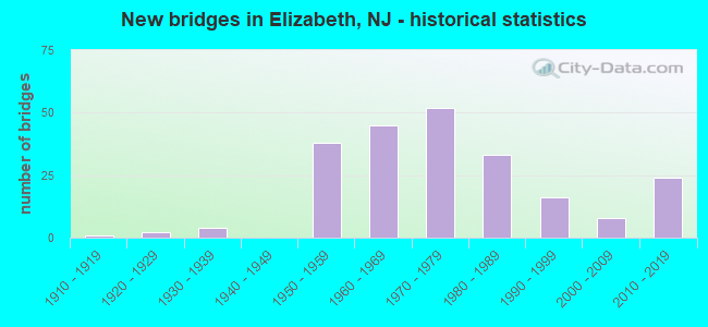
- New bridges - historical statistics
- 11910-1919
- 21920-1929
- 41930-1939
- 381950-1959
- 451960-1969
- 521970-1979
- 331980-1989
- 161990-1999
- 82000-2009
- 242010-2019

- Reconstructed bridges - Historical Statistics
- 11950-1959
- 01960-1969
- 11970-1979
- 311980-1989
- 181990-1999
- 132000-2009
- 22010-2019


- Bridge Condition - Deck
- 7.6%Excellent
- 2.5%Very good
- 61.3%Good
- 22.7%Satisfactory
- 3.4%Fair
- 2.5%Poor

- Bridge Condition - Superstructure
- 6.7%Excellent
- 3.4%Very good
- 29.4%Good
- 48.7%Satisfactory
- 10.1%Fair
- 1.7%Poor
- 0.8%Serious

- Bridge Condition - Substructure
- 6.7%Excellent
- 0.8%Very good
- 14.3%Good
- 52.1%Satisfactory
- 24.4%Fair
- 1.7%Poor

- Bridge Condition - Channel
- 11.1%Excellent
- 25.9%Very good
- 59.3%Good
- 3.7%Satisfactory
Find on map >> Show street view
Structure Number: M10040N, Location: .65 MI N ELIZABETH RIVER (Lat: 40.652058, Lng: -74.195311), Route carried "under" structure: City street , Year Built: 1970, Structure Length: 0. m, Average Daily Traffic: 7,128 (year 2021), Truck Traffic: 1%, Features Intersected: MARSHALL STREET, Facility Carried by Structure: NJ TPK SNO RWY
Minimum Vertical Clearance: 5.23m (17.16ft), Kilometerpoint: 0.000, Lanes on structure: 4, Lanes under structure: 2, Material/Design: Steel, Design/Construction: Stringer/Multi-beam, Length of Maximum Span: 18.9m (62.0ft)
Find on map >> Show street view
Structure Number: M10040S, Location: .65 MI N ELIZABETH RIVER (Lat: 40.652456, Lng: -74.195669), Route carried "under" structure: City street , Year Built: 1970, Structure Length: 0. m, Average Daily Traffic: 7,271 (year 2021), Truck Traffic: 1%, Features Intersected: MARSHALL STREET, Facility Carried by Structure: NJ TPK NSO RWY
Minimum Vertical Clearance: 5.28m (17.32ft), Kilometerpoint: 0.000, Lanes on structure: 4, Lanes under structure: 2, Material/Design: Steel, Design/Construction: Stringer/Multi-beam, Length of Maximum Span: 18.9m (62.0ft)
Find on map >> Show street view
Structure Number: M10045, Location: .7 MI N ELIZABETH RIVER (Lat: 40.652592, Lng: -74.194622), Route carried "under" structure: City street , Year Built: 1950, Structure Length: 0. m, Average Daily Traffic: 7,128 (year 2021), Truck Traffic: 1%, Features Intersected: FRANKLIN STREET, Facility Carried by Structure: NJTPK NSI-SNI RWYS
Minimum Vertical Clearance: 5.79m (19.00ft), Kilometerpoint: 0.000, Lanes on structure: 6, Lanes under structure: 2, Material/Design: Steel, Design/Construction: Stringer/Multi-beam, Length of Maximum Span: 19.5m (64.0ft)
Find on map >> Show street view
Structure Number: M10045N, Location: .7 MI N ELIZABETH RIVER (Lat: 4.077500, Lng: -74.194528), Route carried "under" structure: City street , Year Built: 1968, Structure Length: 0. m, Average Daily Traffic: 6,988 (year 2021), Truck Traffic: 1%, Features Intersected: FRANKLIN STREET, Facility Carried by Structure: TURNPIKE SNO
Minimum Vertical Clearance: 5.08m (16.67ft), Kilometerpoint: 0.000, Lanes on structure: 4, Lanes under structure: 2, Material/Design: Steel, Design/Construction: Stringer/Multi-beam, Length of Maximum Span: 41.8m (137.1ft)
Find on map >> Show street view
Structure Number: M10045S, Location: .7 MI N ELIZABETH RIVER (Lat: 40.652883, Lng: -74.194958), Route carried "under" structure: City street , Year Built: 1968, Structure Length: 0. m, Average Daily Traffic: 6,988 (year 2021), Truck Traffic: 1%, Features Intersected: FRANKLIN STREET, Facility Carried by Structure: TURNPIKE NSO
Minimum Vertical Clearance: 5.76m (18.90ft), Kilometerpoint: 0.000, Lanes on structure: 4, Lanes under structure: 2, Material/Design: Steel, Design/Construction: Stringer/Multi-beam, Length of Maximum Span: 18.9m (62.0ft)
Find on map >> Show street view
Structure Number: M1005, Location: .75 MI N ELIZABETH RIVER (Lat: 40.653442, Lng: -74.193100), Route carried "under" structure: City street , Year Built: 1950, Structure Length: 0. m, Average Daily Traffic: 6,988 (year 2021), Truck Traffic: 1%, Features Intersected: FULTON STREET, Facility Carried by Structure: NJTPK NSI-SNI RWYS
Minimum Vertical Clearance: 5.16m (16.93ft), Kilometerpoint: 0.000, Lanes on structure: 6, Lanes under structure: 2, Material/Design: Steel, Design/Construction: Stringer/Multi-beam, Length of Maximum Span: 18.9m (62.0ft)
Find on map >> Show street view
Structure Number: M10050N, Location: .75 MI N ELIZABETH RIVER (Lat: 40.652917, Lng: -74.193750), Route carried "under" structure: City street , Year Built: 1970, Structure Length: 0. m, Average Daily Traffic: 6,988 (year 2019), Truck Traffic: 1%, Features Intersected: FULTON STREET, Facility Carried by Structure: NJ TPK SNO RWY
Minimum Vertical Clearance: 4.95m (16.24ft), Kilometerpoint: 0.000, Lanes on structure: 4, Lanes under structure: 2, Material/Design: Steel, Design/Construction: Stringer/Multi-beam, Length of Maximum Span: 40.2m (131.9ft)
Find on map >> Show street view
Structure Number: M10050S, Location: .75 MI N ELIZABETH RIVER (Lat: 40.653275, Lng: -74.194072), Route carried "under" structure: City street , Year Built: 1970, Structure Length: 0. m, Average Daily Traffic: 6,988 (year 2021), Truck Traffic: 1%, Features Intersected: FULTON STREET, Facility Carried by Structure: NJ TPK NSO RWY
Minimum Vertical Clearance: 5.03m (16.50ft), Kilometerpoint: 0.000, Lanes on structure: 4, Lanes under structure: 2, Material/Design: Steel, Design/Construction: Stringer/Multi-beam, Length of Maximum Span: 19.2m (63.0ft)
Find on map >> Show street view
Structure Number: M10055, Location: .8 MI N ELIZABETH RIVER (Lat: 40.653561, Lng: -74.193214), Route carried "under" structure: City street , Year Built: 1950, Structure Length: 0. m, Average Daily Traffic: 17,847 (year 2021), Truck Traffic: 4%, Features Intersected: EAST JERSEY STREET, Facility Carried by Structure: NJTPK NSI-SNI RWYS
Minimum Vertical Clearance: 4.98m (16.34ft), Kilometerpoint: 2.832, Lanes on structure: 6, Lanes under structure: 2, Material/Design: Steel, Design/Construction: Stringer/Multi-beam, Length of Maximum Span: 19.2m (63.0ft)
Find on map >> Show street view
Structure Number: M10055N, Location: .8 MI N ELIZABETH RIVER (Lat: 40.653194, Lng: -74.192864), Route carried "under" structure: City street , Year Built: 1969, Structure Length: 0. m, Average Daily Traffic: 4,734 (year 2021), Truck Traffic: 4%, Features Intersected: EAST JERSEY STREET, Facility Carried by Structure: NJ TPK SNO RWY
Minimum Vertical Clearance: 4.82m (15.81ft), Kilometerpoint: 2.832, Lanes on structure: 4, Lanes under structure: 2, Toll: On toll road, Material/Design: Steel, Design/Construction: Stringer/Multi-beam, Length of Maximum Span: 38.1m (125.0ft)
Find on map >> Show street view
Structure Number: M10055S, Location: .8 MI N ELIZABETH RIVER (Lat: 40.653333, Lng: -74.193333), Route carried "under" structure: City street , Year Built: 1968, Structure Length: 0. m, Average Daily Traffic: 17,847 (year 2021), Truck Traffic: 1%, Features Intersected: EAST JERSEY STREET, Facility Carried by Structure: Turnpike NSO
Minimum Vertical Clearance: 4.78m (15.68ft), Kilometerpoint: 2.800, Lanes on structure: 4, Lanes under structure: 2, Material/Design: Steel, Design/Construction: Stringer/Multi-beam, Length of Maximum Span: 19.2m (63.0ft)
Find on map >> Show street view
Structure Number: M1006, Location: .85 MI N ELIZABETH RIVER (Lat: 40.654000, Lng: -74.192444), Route carried "under" structure: City street , Year Built: 1950, Structure Length: 0. m, Average Daily Traffic: 7,128 (year 2021), Truck Traffic: 1%, Features Intersected: LIVINGSTON STREET, Facility Carried by Structure: TURNPIKE NSI/SNI
Minimum Vertical Clearance: 4.60m (15.09ft), Kilometerpoint: 0.000, Lanes on structure: 6, Lanes under structure: 2, Material/Design: Steel, Design/Construction: Stringer/Multi-beam, Length of Maximum Span: 18.6m (61.0ft)
Find on map >> Show street view
Structure Number: M10060N, Location: .85 MI N ELIZABETH RIVER (Lat: 40.653750, Lng: -74.192222), Route carried "under" structure: City street , Year Built: 1969, Structure Length: 0. m, Average Daily Traffic: 7,128 (year 2021), Truck Traffic: 1%, Features Intersected: LIVINGSTON STREET, Facility Carried by Structure: NJ TPK SNO RWY
Minimum Vertical Clearance: 4.67m (15.32ft), Kilometerpoint: 0.000, Lanes on structure: 4, Lanes under structure: 2, Material/Design: Steel, Design/Construction: Stringer/Multi-beam, Length of Maximum Span: 18.9m (62.0ft)
Find on map >> Show street view
Structure Number: M10060S, Location: .85 MI N ELIZABETH RIVER (Lat: 40.654139, Lng: -74.192583), Route carried "under" structure: City street , Year Built: 1968, Structure Length: 0. m, Average Daily Traffic: 7,128 (year 2021), Truck Traffic: 1%, Features Intersected: LIVINGSTON STREET, Facility Carried by Structure: TURNPIKE NSO
Minimum Vertical Clearance: 4.34m (14.24ft), Kilometerpoint: 0.000, Lanes on structure: 4, Lanes under structure: 2, Material/Design: Steel, Design/Construction: Stringer/Multi-beam, Length of Maximum Span: 18.9m (62.0ft)
Find on map >> Show street view
Structure Number: M10076, Location: 1.65 MI NE OF BAY WAY CIR (Lat: 40.655358, Lng: -74.190122), Route carried "under" structure: City street , Year Built: 1950, Structure Length: 0. m, Average Daily Traffic: 2,865 (year 2021), Truck Traffic: 1%, Features Intersected: COURT STREET, Facility Carried by Structure: NJTPK NSI-SNI RWYS
Minimum Vertical Clearance: 4.62m (15.16ft), Kilometerpoint: 0.000, Lanes on structure: 6, Lanes under structure: 2, Material/Design: Steel, Design/Construction: Stringer/Multi-beam, Length of Maximum Span: 19.2m (63.0ft)
Find on map >> Show street view
Structure Number: M10076N, Location: 1.65 MI NE OF BAY WAY CIR (Lat: 40.654975, Lng: -74.189717), Route carried "under" structure: City street , Year Built: 1970, Structure Length: 0. m, Average Daily Traffic: 2,754 (year 2021), Truck Traffic: 1%, Features Intersected: COURT STREET, Facility Carried by Structure: NJ TPK SNO RWY
Minimum Vertical Clearance: 4.57m (14.99ft), Kilometerpoint: 0.000, Lanes on structure: 4, Lanes under structure: 2, Material/Design: Steel, Design/Construction: Stringer/Multi-beam, Length of Maximum Span: 18.9m (62.0ft)
Find on map >> Show street view
Structure Number: M10076S, Location: 1.65 MI NE OF BAY WAY CIR (Lat: 40.655500, Lng: -74.190242), Route carried "under" structure: City street , Year Built: 1968, Structure Length: 0. m, Average Daily Traffic: 2,865 (year 2021), Truck Traffic: 1%, Features Intersected: COURT STREET, Facility Carried by Structure: TURNPIKE NSO
Minimum Vertical Clearance: 4.44m (14.57ft), Kilometerpoint: 0.000, Lanes on structure: 4, Lanes under structure: 2, Material/Design: Steel, Design/Construction: Stringer/Multi-beam, Length of Maximum Span: 19.2m (63.0ft)
Find on map >> Show street view
Structure Number: M10103, Location: 1.87 MI NE OF BAY WAY CIR (Lat: 40.657606, Lng: -74.187553), Route carried "under" structure: City street , Year Built: 1951, Structure Length: 0. m, Average Daily Traffic: 7,348 (year 2021), Truck Traffic: 4%, Features Intersected: TRUMBULL ST & CRR OF NJ, Facility Carried by Structure: NJTPK NSI-SNI RWYS
Minimum Vertical Clearance: 11.53m (37.83ft), Kilometerpoint: 2.623, Lanes on structure: 6, Lanes under structure: 2, Material/Design: Steel, Design/Construction: Stringer/Multi-beam, Length of Maximum Span: 45.1m (148.0ft)
Find on map >> Show street view
Structure Number: M10103N, Location: 1.87 MI NE OF BAY WAY CIR (Lat: 40.658439, Lng: -74.186486), Route carried "under" structure: City street , Year Built: 1970, Structure Length: 0. m, Average Daily Traffic: 7,348 (year 2021), Truck Traffic: 4%, Features Intersected: TRUMBULL ST & CRR OF NJ, Facility Carried by Structure: NJ TPK SNO RWY
Minimum Vertical Clearance: 11.43m (37.50ft), Kilometerpoint: 2.623, Lanes on structure: 4, Lanes under structure: 2, Toll: On toll road, Material/Design: Steel, Design/Construction: Stringer/Multi-beam, Length of Maximum Span: 43.6m (143.0ft)
Find on map >> Show street view
Structure Number: M10103S, Location: 1.87 MI NE OF BAY WAY CIR (Lat: 40.657692, Lng: -74.188056), Route carried "under" structure: City street , Year Built: 1968, Structure Length: 0. m, Average Daily Traffic: 7,348 (year 2021), Truck Traffic: 1%, Features Intersected: TRUMBULL ST & CRR OF NJ, Facility Carried by Structure: NJTPK NSO RWY
Minimum Vertical Clearance: 10.64m (34.91ft), Kilometerpoint: 2.623, Lanes on structure: 4, Lanes under structure: 2, Material/Design: Steel, Design/Construction: Stringer/Multi-beam, Length of Maximum Span: 46.3m (151.9ft)
Find on map >> Show street view
Structure Number: M10121, Location: 2.0 MI NE OF BAY WAY CIR (Lat: 40.660761, Lng: -74.185661), Route carried "under" structure: City street , Year Built: 1950, Structure Length: 0. m, Average Daily Traffic: 8,686 (year 2021), Truck Traffic: 1%, Features Intersected: DOWD AVENUE & TPK.U-TURN, Facility Carried by Structure: NJTPK NSI/SNI
Minimum Vertical Clearance: 7.06m (23.16ft), Kilometerpoint: 0.338, Lanes on structure: 7, Lanes under structure: 2, Material/Design: Steel, Design/Construction: Stringer/Multi-beam, Length of Maximum Span: 25.9m (85.0ft)
Find on map >> Show street view
Structure Number: M10121, Location: 2.0 MI NE OF BAY WAY CIR (Lat: 40.660761, Lng: -74.185661), Route carried "under" structure: Ramp Interstate 95, Year Built: 1950, Structure Length: 0. m, Average Daily Traffic: 297 (year 2021), Features Intersected: DOWD AVENUE & TPK.U-TURN, Facility Carried by Structure: NJTPK NSI/SNI
Minimum Vertical Clearance: 4.47m (14.67ft), Kilometerpoint: 89.914, Lanes on structure: 7, Lanes under structure: 2, Toll: On toll road, Material/Design: Steel, Design/Construction: Stringer/Multi-beam, Length of Maximum Span: 25.9m (85.0ft)
Find on map >> Show street view
Structure Number: M10121N, Location: 2.0 MI NE OF BAY WAY CIR (Lat: 40.660556, Lng: -74.185278), Route carried "under" structure: Ramp Interstate 95, Year Built: 1970, Structure Length: 0. m, Average Daily Traffic: 297 (year 2021), Features Intersected: YORK ST & TPK.U-TURN, Facility Carried by Structure: NJ TPK SNO RWY
Minimum Vertical Clearance: 4.95m (16.24ft), Kilometerpoint: 89.914, Lanes on structure: 5, Lanes under structure: 2, Toll: On toll road, Material/Design: Steel, Design/Construction: Stringer/Multi-beam, Length of Maximum Span: 26.8m (87.9ft)
Find on map >> Show street view
Structure Number: M10121N, Location: 2.0 MI NE OF BAY WAY CIR (Lat: 40.660556, Lng: -74.185278), Route carried "under" structure: City street , Year Built: 1970, Structure Length: 0. m, Average Daily Traffic: 8,686 (year 2021), Truck Traffic: 1%, Features Intersected: YORK ST & TPK.U-TURN, Facility Carried by Structure: NJ TPK SNO RWY
Minimum Vertical Clearance: 7.70m (25.26ft), Kilometerpoint: 0.338, Lanes on structure: 5, Lanes under structure: 2, Material/Design: Steel, Design/Construction: Stringer/Multi-beam, Length of Maximum Span: 26.8m (87.9ft)
Find on map >> Show street view
Structure Number: M10121S, Location: 2.0 MI NE OF BAY WAY CIR (Lat: 40.660981, Lng: -74.185919), Route carried "under" structure: City street , Year Built: 1970, Structure Length: 0. m, Average Daily Traffic: 8,686 (year 2021), Truck Traffic: 1%, Features Intersected: YORK ST & TPK U-TURN, Facility Carried by Structure: NJ TPK NSO RWY
Minimum Vertical Clearance: 6.40m (21.00ft), Kilometerpoint: 0.338, Lanes on structure: 4, Lanes under structure: 2, Material/Design: Steel, Design/Construction: Stringer/Multi-beam, Length of Maximum Span: 31.4m (103.0ft)
Find on map >> Show street view
Structure Number: M10121S, Location: 2.0 MI NE OF BAY WAY CIR (Lat: 40.660981, Lng: -74.185919), Route carried "under" structure: Ramp Interstate 95, Year Built: 1970, Structure Length: 0. m, Average Daily Traffic: 297 (year 2021), Truck Traffic: 1%, Features Intersected: YORK ST & TPK U-TURN, Facility Carried by Structure: NJ TPK NSO RWY
Minimum Vertical Clearance: 4.47m (14.67ft), Kilometerpoint: 89.914, Lanes on structure: 4, Lanes under structure: 2, Toll: On toll road, Material/Design: Steel, Design/Construction: Stringer/Multi-beam, Length of Maximum Span: 31.4m (103.0ft)
Find on map >> Show street view
Structure Number: M10147A, Location: 2.1 MI NE OF BAY WAY CIR (Lat: 40.663333, Lng: -74.183333), Route carried "under" structure: Interstate 95, Year Built: 1970, Structure Length: 0. m, Average Daily Traffic: 61,129 (year 2021), Truck Traffic: 31%, Features Intersected: NJ TPK RWY NBO&RAMP SOT, Facility Carried by Structure: NJTPK INT 13A SIT
Minimum Vertical Clearance: 5.05m (16.57ft), Kilometerpoint: 90.381, Lanes on structure: 1, Lanes under structure: 4, Toll: On toll road, Material/Design: Steel, Design/Construction: Stringer/Multi-beam, Length of Maximum Span: 30.5m (100.1ft)
Find on map >> Show street view
Structure Number: M10147A, Location: 2.1 MI NE OF BAY WAY CIR (Lat: 40.663333, Lng: -74.183333), Route carried "under" structure: Ramp Interstate 95, Year Built: 1970, Structure Length: 0. m, Average Daily Traffic: 2,919 (year 2021), Features Intersected: NJ TPK RWY NBO&RAMP SOT, Facility Carried by Structure: NJTPK INT 13A SIT
Minimum Vertical Clearance: 5.21m (17.09ft), Kilometerpoint: 90.381, Lanes on structure: 1, Lanes under structure: 1, Toll: On toll road, Material/Design: Steel, Design/Construction: Stringer/Multi-beam, Length of Maximum Span: 30.5m (100.1ft)
Find on map >> Show street view
Structure Number: M10153A, Location: 3.21 MI S INT.14 (Lat: 40.664761, Lng: -74.183039), Route carried "under" structure: Interstate 95, Year Built: 1981, Structure Length: 0. m, Average Daily Traffic: 61,129 (year 2021), Truck Traffic: 31%, Features Intersected: NJ TPK NSO ROADWAY, Facility Carried by Structure: NJ TPK INT 13A TSI
Minimum Vertical Clearance: 5.89m (19.32ft), Kilometerpoint: 90.381, Lanes on structure: 1, Lanes under structure: 4, Toll: On toll road, Material/Design: Steel, Design/Construction: Stringer/Multi-beam, Length of Maximum Span: 42.7m (140.1ft)
Find on map >> Show street view
Structure Number: M10154A, Location: 3.2 MI S OF INT .14 (Lat: 40.665556, Lng: -74.182811), Route carried "under" structure: Ramp Interstate 95, Year Built: 1982, Structure Length: 0. m, Average Daily Traffic: 299,665 (year 2021), Truck Traffic: 31%, Features Intersected: NJ TURNPIKE, Facility Carried by Structure: NJ TPK INT.13A TN
Minimum Vertical Clearance: 5.69m (18.67ft), Kilometerpoint: 90.429, Lanes on structure: 1, Lanes under structure: 14, Toll: On toll road, Material/Design: Steel, Design/Construction: Stringer/Multi-beam, Length of Maximum Span: 37.2m (122.0ft)
Find on map >> Show street view
Structure Number: M10165A, Location: 3.09 MI S INT.14 (Lat: 40.666767, Lng: -74.181836), Route carried "under" structure: Interstate 95, Year Built: 1982, Structure Length: 0. m, Average Daily Traffic: 299,640 (year 2021), Truck Traffic: 31%, Features Intersected: NJ TPK RWYS & RAMP TN, Facility Carried by Structure: NJTPK INT.13A SIT-
Minimum Vertical Clearance: 7.28m (23.88ft), Kilometerpoint: 90.622, Lanes on structure: 2, Lanes under structure: 14, Toll: On toll road, Material/Design: Steel, Design/Construction: Stringer/Multi-beam, Length of Maximum Span: 38.1m (125.0ft)
Find on map >> Show street view
Structure Number: M10165A, Location: 3.09 MI S INT.14 (Lat: 40.666767, Lng: -74.181836), Route carried "under" structure: Ramp Interstate 95, Year Built: 1982, Structure Length: 0. m, Average Daily Traffic: 8,590 (year 2021), Truck Traffic: 14%, Features Intersected: NJ TPK RWYS & RAMP TN, Facility Carried by Structure: NJTPK INT.13A SIT-
Minimum Vertical Clearance: 5.13m (16.83ft), Kilometerpoint: 90.622, Lanes on structure: 2, Lanes under structure: 1, Toll: On toll road, Material/Design: Steel, Design/Construction: Stringer/Multi-beam, Length of Maximum Span: 38.1m (125.0ft)
Find on map >> Show street view
Structure Number: M10168A, Location: 3.06 MI S INT .14 (Lat: 40.667050, Lng: -74.181300), Route carried "under" structure: Interstate 95, Year Built: 1979, Structure Length: 0. m, Average Daily Traffic: 61,130 (year 2021), Truck Traffic: 31%, Features Intersected: NJ TPK NSO ROADWAY, Facility Carried by Structure: NJ TPK INT 13A NIT
Minimum Vertical Clearance: 4.75m (15.58ft), Kilometerpoint: 90.703, Lanes on structure: 1, Lanes under structure: 4, Toll: On toll road, Material/Design: Steel, Design/Construction: Stringer/Multi-beam, Length of Maximum Span: 28.7m (94.2ft)
Find on map >> Show street view
Structure Number: M10168B, Location: 3 MI SO OF NJ TPK INT14 (Lat: 40.669933, Lng: -74.181303), Route carried "under" structure: ServiceState highway 95, Year Built: 1999, Structure Length: 0. m, Average Daily Traffic: 5,202 (year 2021), Truck Traffic: 1%, Features Intersected: NJ TURNPIKE NASE ROADWAY, Facility Carried by Structure: INT. 13A RAMP ET
Minimum Vertical Clearance: 4.42m (14.50ft), Kilometerpoint: 90.735, Lanes on structure: 1, Lanes under structure: 2, Material/Design: Steel, Design/Construction: Stringer/Multi-beam, Length of Maximum Span: 28.3m (92.8ft)
Find on map >> Show street view
Structure Number: M10168C, Location: 3 MI SO OF NJ TPK INT14 (Lat: 40.671386, Lng: -74.182714), Route carried "under" structure: Ramp Interstate 95, Year Built: 1999, Structure Length: 0. m, Average Daily Traffic: 5,840 (year 2021), Truck Traffic: 9%, Features Intersected: NORTH AVENUE EASTBOUND, Facility Carried by Structure: NJ TPK INT 13A ET
Minimum Vertical Clearance: 5.00m (16.40ft), Kilometerpoint: 90.622, Lanes on structure: 1, Lanes under structure: 1, Toll: On toll road, Material/Design: Steel continuous, Design/Construction: Stringer/Multi-beam, Length of Maximum Span: 42.7m (140.1ft)
Find on map >> Show street view
Structure Number: M10168D, Location: 3 MI SO OF NJ TPK INT14 (Lat: 40.672319, Lng: -74.185989), Route carried "under" structure: State highway 81, Year Built: 1999, Structure Length: 0. m, Average Daily Traffic: 8,161 (year 2021), Features Intersected: TPK WLT/WXT/TWX/TWL&N AV, Facility Carried by Structure: NJ TPK 13A ET&ET1
Minimum Vertical Clearance: 7.62m (25.00ft), Kilometerpoint: 0.418, Lanes on structure: 2, Lanes under structure: 4, Toll: On toll road, Material/Design: Steel continuous, Design/Construction: Stringer/Multi-beam, Length of Maximum Span: 34.7m (113.8ft)
Find on map >> Show street view
Structure Number: M10168D, Location: 3 MI SO OF NJ TPK INT14 (Lat: 40.672319, Lng: -74.185989), Route carried "under" structure: Ramp Interstate 81, Year Built: 1999, Structure Length: 0. m, Average Daily Traffic: 5,203 (year 2021), Features Intersected: TPK WLT/WXT/TWX/TWL&N AV, Facility Carried by Structure: NJ TPK 13A ET&ET1
Minimum Vertical Clearance: 6.68m (21.92ft), Kilometerpoint: 0.418, Lanes on structure: 2, Lanes under structure: 1, Toll: On toll road, Material/Design: Steel continuous, Design/Construction: Stringer/Multi-beam, Length of Maximum Span: 34.7m (113.8ft)
Find on map >> Show street view
Structure Number: M10168D, Location: 3 MI SO OF NJ TPK INT14 (Lat: 40.672319, Lng: -74.185989), Route carried "under" structure: City street , Year Built: 1999, Structure Length: 0. m, Average Daily Traffic: 17,930 (year 2021), Truck Traffic: 4%, Features Intersected: TPK WLT/WXT/TWX/TWL&N AV, Facility Carried by Structure: NJ TPK 13A ET&ET1
Minimum Vertical Clearance: 5.41m (17.75ft), Kilometerpoint: 2.140, Lanes on structure: 2, Lanes under structure: 2, Material/Design: Steel continuous, Design/Construction: Stringer/Multi-beam, Length of Maximum Span: 34.7m (113.8ft)
Find on map >> Show street view
Structure Number: M10168D, Location: 3 MI SO OF NJ TPK INT14 (Lat: 40.672319, Lng: -74.185989), Route carried "under" structure: Ramp Interstate 81, Year Built: 1999, Structure Length: 0. m, Average Daily Traffic: 5,203 (year 2021), Features Intersected: TPK WLT/WXT/TWX/TWL&N AV, Facility Carried by Structure: NJ TPK 13A ET&ET1
Minimum Vertical Clearance: 7.72m (25.33ft), Kilometerpoint: 0.418, Lanes on structure: 2, Lanes under structure: 2, Toll: On toll road, Material/Design: Steel continuous, Design/Construction: Stringer/Multi-beam, Length of Maximum Span: 34.7m (113.8ft)
Find on map >> Show street view
Structure Number: M10177, Location: 3 MI SO OF NJ TPK INT14 (Lat: 4.068292, Lng: -74.180411), Route carried "under" structure: Interstate 95, Year Built: 1999, Structure Length: 0. m, Average Daily Traffic: 249,616 (year 2021), Truck Traffic: 15%, Features Intersected: NJ TPK & INT 13A RAMPS, Facility Carried by Structure: JERSEY GARDEN BLVD
Minimum Vertical Clearance: 6.73m (22.08ft), Kilometerpoint: 90.799, Lanes on structure: 4, Lanes under structure: 17, Toll: On toll road, Material/Design: Steel continuous, Design/Construction: Stringer/Multi-beam, Length of Maximum Span: 47.9m (157.2ft)
Find on map >> Show street view
Structure Number: M10210A, Location: 2.64 MI S INT.14 (Lat: 40.670833, Lng: -74.176011), Route carried "under" structure: Interstate 95, Year Built: 1970, Structure Length: 0. m, Average Daily Traffic: 61,129 (year 2021), Truck Traffic: 31%, Features Intersected: NJ TPK SNO ROADWAY, Facility Carried by Structure: RAMP TNI
Minimum Vertical Clearance: 5.08m (16.67ft), Kilometerpoint: 91.427, Lanes on structure: 1, Lanes under structure: 4, Toll: On toll road, Material/Design: Steel, Design/Construction: Stringer/Multi-beam, Length of Maximum Span: 31.7m (104.0ft)
Find on map >> Show street view
Structure Number: M10341A, Location: 1.33 MI So.Int. 14 (Lat: 40.687686, Lng: -74.164967), Route carried "under" structure: Interstate 95, Year Built: 1969, Structure Length: 0. m, Average Daily Traffic: 281,560 (year 2021), Truck Traffic: 14%, Features Intersected: NJ TURNPIKE, Facility Carried by Structure: NJTPK 103 U-TURN
Minimum Vertical Clearance: 5.00m (16.40ft), Kilometerpoint: 93.406, Lanes on structure: 2, Lanes under structure: 14, Toll: On toll road, Material/Design: Steel continuous, Design/Construction: Stringer/Multi-beam, Length of Maximum Span: 38.1m (125.0ft)