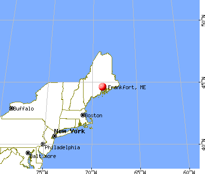
Frankfort, Maine
Submit your own pictures of this town and show them to the world
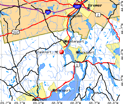
- OSM Map
- General Map
- Google Map
- MSN Map
Population change since 2000: +8.0%
 |
| Males: 560 | |
| Females: 564 |
| Median resident age: | 41.6 years |
| Maine median age: | 43.0 years |
Zip codes: 04438.
| Frankfort: | $62,653 |
| ME: | $69,543 |
Estimated per capita income in 2022: $30,815 (it was $14,524 in 2000)
Frankfort town income, earnings, and wages data
Estimated median house or condo value in 2022: $198,015 (it was $67,800 in 2000)
| Frankfort: | $198,015 |
| ME: | $290,600 |
Mean prices in 2022: all housing units: $270,070; detached houses: $293,055; townhouses or other attached units: $325,130; in 2-unit structures: $297,158; in 3-to-4-unit structures: $211,194; in 5-or-more-unit structures: $284,526; mobile homes: $128,233; occupied boats, rvs, vans, etc.: $21,180
Detailed information about poverty and poor residents in Frankfort, ME


Compare current foreclosures near Frankfort, ME:
| Photo | Address | Area | Beds / Baths | Price | Details |
|---|---|---|---|---|---|

|
#1
Indian Hill Ln
Frankfort, ME 04438
|
- sq. feet
|
- baths - beds |
show details | |

|
#2
Mount Ephraim Rd
Searsport, ME 04974
|
1,972 sq. feet
|
2 baths 4 beds |
$154,900
|
show details |

|
#3
Surry Rd
Orland, ME 04472
|
- sq. feet
|
4 baths 5 beds |
$174,900
|
show details |

|
#4
Smokey Ln
Bangor, ME 04401
|
2,434 sq. feet
|
2 baths 3 beds |
show details | |

|
#5
Central St
Bucksport, ME 04416
|
- sq. feet
|
- baths - beds |
$63,000
|
show details |

|
#6
Maxwell Ln
Bangor, ME 04401
|
1,750 sq. feet
|
2 baths 3 beds |
show details | |

|
#7
Western Ave
Hampden, ME 04444
|
1,825 sq. feet
|
1 baths 3 beds |
show details | |

|
#8
Western Ave
Hampden, ME 04444
|
1,976 sq. feet
|
2 baths 4 beds |
show details | |

|
#9
Warren St
Bangor, ME 04401
|
2,842 sq. feet
|
3 baths 5 beds |
show details | |

|
#10
Rd
Brewer, ME 04412
|
2,428 sq. feet
|
1 baths 4 beds |
show details |
| Photo | Address | Area | Beds / Baths | Price | Details |
|---|---|---|---|---|---|

|
#11
Hatch Rd
Brooks, ME 04921
|
1,092 sq. feet
|
1 baths 2 beds |
show details | |

|
#12
Lancaster Ave
Bangor, ME 04401
|
324 sq. feet
|
1 baths 1 beds |
show details | |

|
#13
Grove St
Bangor, ME 04401
|
910 sq. feet
|
1 baths 3 beds |
show details | |

|
#14
Allen St
Bangor, ME 04401
|
1,200 sq. feet
|
1 baths 3 beds |
show details | |

|
#15
Hampden Rd
Carmel, ME 04419
|
- sq. feet
|
- baths - beds |
show details | |

|
#16
Pleasant Hill Ln
Orrington, ME 04474
|
- sq. feet
|
- baths - beds |
show details | |

|
#17
Muskrat Farm Rd
Stockton Springs, ME 04981
|
- sq. feet
|
- baths - beds |
show details | |

|
#18
Baker Blvd Ste 205
Brewer, ME 04412
|
- sq. feet
|
- baths - beds |
show details | |

|
#19
Pine St # B
Bangor, ME 04401
|
- sq. feet
|
- baths - beds |
show details | |

|
#20
Cedar St Apt 4
Bangor, ME 04401
|
- sq. feet
|
- baths - beds |
show details |
| Photo | Address | Area | Beds / Baths | Price | Details |
|---|---|---|---|---|---|

|
#21
Front Ridge Rd
Penobscot, ME 04476
|
- sq. feet
|
- baths - beds |
show details | |

|
#22
Loop Rd
Searsport, ME 04974
|
- sq. feet
|
- baths - beds |
show details | |

|
#23
Stillwater Ave
Bangor, ME 04401
|
- sq. feet
|
- baths - beds |
show details | |

|
#24
Gott Brook Hts
Orland, ME 04472
|
- sq. feet
|
- baths - beds |
show details | |

|
#25
Hinks St
Bucksport, ME 04416
|
- sq. feet
|
- baths - beds |
show details | |

|
#26
Purple Heart Hwy
Brooks, ME 04921
|
- sq. feet
|
- baths - beds |
show details | |

|
#27
South Rd
Brewer, ME 04412
|
- sq. feet
|
- baths - beds |
show details | |

|
#28
S Road
Brewer, ME 04412
|
- sq. feet
|
- baths - beds |
show details | |

|
#29
Kenduskeag Ave # 24
Bangor, ME 04401
|
- sq. feet
|
- baths - beds |
show details | |

|
#30
Central St
Bucksport, ME 04416
|
- sq. feet
|
- baths - beds |
show details |
| Photo | Address | Area | Beds / Baths | Price | Details |
|---|---|---|---|---|---|

|
#31
Treats Falls Dr
Brewer, ME 04412
|
- sq. feet
|
- baths - beds |
show details | |
|
|
#32
York Rd
Bangor, ME 04401
|
- sq. feet
|
- baths - beds |
show details | |

|
#33
Jesse Robbins Rd
Belfast, ME 04915
|
- sq. feet
|
- baths - beds |
show details | |

|
Check over 1 million property listings on Foreclosure.com!
|
browse all offers | |||

- 1,11098.8%White alone
- 50.4%Asian alone
- 40.4%Hispanic
- 30.3%Black alone
- 10.09%American Indian alone
- 10.09%Two or more races

Races in Frankfort detailed stats: ancestries, foreign born residents, place of birth
According to our research of Maine and other state lists, there were 3 registered sex offenders living in Frankfort, Maine as of May 12, 2024.
The ratio of all residents to sex offenders in Frankfort is 375 to 1.
 Recent articles from our blog. Our writers, many of them Ph.D. graduates or candidates, create easy-to-read articles on a wide variety of topics.


 | Frankfort area? (0 replies) |
| Bill submitted to allow Maine gun owners to carry concealed without permit (296 replies) |
| Re - Locating back to Maine (13 replies) |
| ellsworth (17 replies) |
| Will Need To Relocate A Little South - Your Wisdom And Advice, Please? (102 replies) |
| Looking for a small piece of land (0 replies) |
Latest news from Frankfort, ME collected exclusively by city-data.com from local newspapers, TV, and radio stations
Ancestries: English (19.7%), United States (17.6%), Irish (11.5%), French (4.3%), Swedish (3.5%), French Canadian (3.4%).
Current Local Time: EST time zone
Incorporated on 06/25/1789
Elevation: 53 feet
Land area: 24.6 square miles.
Population density: 46 people per square mile (very low).
11 residents are foreign born
| This town: | 1.1% |
| Maine: | 2.9% |
| Frankfort town: | 1.4% ($970) |
| Maine: | 1.5% ($1,417) |
Nearest city with pop. 50,000+: Portland, ME  (94.0 miles , pop. 64,249).
Nearest city with pop. 200,000+: Boston, MA (192.5 miles , pop. 589,141).
Nearest city with pop. 1,000,000+: Bronx, NY (362.3 miles , pop. 1,332,650).
Nearest cities:
), ), ), ), )Latitude: 44.61 N, Longitude: 68.91 W
Area code commonly used in this area: 207


| Here: | 6.2% |
| Maine: | 3.4% |


- Health care (13.8%)
- Construction (9.4%)
- Finance & insurance (7.3%)
- Educational services (6.9%)
- Paper (6.5%)
- Food & beverage stores (6.3%)
- Agriculture, forestry, fishing & hunting (3.1%)

- Construction (17.7%)
- Paper (11.0%)
- Finance & insurance (7.5%)
- Agriculture, forestry, fishing & hunting (5.9%)
- Educational services (4.3%)
- Transportation equipment (3.9%)
- Food & beverage stores (3.9%)

- Health care (25.6%)
- Educational services (9.9%)
- Food & beverage stores (9.0%)
- Finance & insurance (7.2%)
- Social assistance (4.5%)
- Department & other general merchandise stores (3.6%)
- Professional, scientific, technical services (3.6%)

- Other production occupations, including supervisors (7.5%)
- Building and grounds cleaning and maintenance occupations (4.8%)
- Driver/sales workers and truck drivers (4.6%)
- Carpenters (4.2%)
- Other sales and related occupations, including supervisors (3.4%)
- Preschool, kindergarten, elementary, and middle school teachers (3.1%)
- Laborers and material movers, hand (2.7%)

- Other production occupations, including supervisors (9.4%)
- Carpenters (7.9%)
- Driver/sales workers and truck drivers (7.1%)
- Metal workers and plastic workers (4.7%)
- Other sales and related occupations, including supervisors (4.3%)
- Laborers and material movers, hand (4.3%)
- Vehicle and mobile equipment mechanics, installers, and repairers (4.3%)

- Preschool, kindergarten, elementary, and middle school teachers (6.7%)
- Building and grounds cleaning and maintenance occupations (6.7%)
- Other production occupations, including supervisors (5.4%)
- Health technologists and technicians (4.9%)
- Nursing, psychiatric, and home health aides (4.9%)
- Cashiers (4.5%)
- Other healthcare support occupations (4.0%)
Average climate in Frankfort, Maine
Based on data reported by over 4,000 weather stations


(lower is better)

Air Quality Index (AQI) level in 2023 was 61.1. This is about average.
| City: | 61.1 |
| U.S.: | 72.6 |

Ozone [ppb] level in 2023 was 33.6. This is about average. Closest monitor was 9.0 miles away from the city center.
| City: | 33.6 |
| U.S.: | 33.3 |

Particulate Matter (PM2.5) [µg/m3] level in 2023 was 5.62. This is significantly better than average. Closest monitor was 14.7 miles away from the city center.
| City: | 5.62 |
| U.S.: | 8.11 |
Earthquake activity:
Frankfort-area historical earthquake activity is significantly above Maine state average. It is 79% smaller than the overall U.S. average.On 10/16/2012 at 23:12:25, a magnitude 4.7 (4.7 ML, Depth: 10.0 mi, Class: Light, Intensity: IV - V) earthquake occurred 111.5 miles away from Frankfort center
On 4/20/2002 at 10:50:47, a magnitude 5.3 (5.3 ML, Depth: 3.0 mi, Class: Moderate, Intensity: VI - VII) earthquake occurred 235.9 miles away from the city center
On 4/20/2002 at 10:50:47, a magnitude 5.2 (5.2 MB, 4.2 MS, 5.2 MW, 5.0 MW) earthquake occurred 237.0 miles away from the city center
On 1/19/1982 at 00:14:42, a magnitude 4.7 (4.5 MB, 4.7 MD, 4.5 LG) earthquake occurred 154.2 miles away from the city center
On 10/7/1983 at 10:18:46, a magnitude 5.3 (5.1 MB, 5.3 LG, 5.1 ML) earthquake occurred 272.7 miles away from the city center
On 2/26/1999 at 03:38:43, a magnitude 3.8 (3.8 LG, Depth: 2.0 mi, Class: Light, Intensity: II - III) earthquake occurred 31.4 miles away from Frankfort center
Magnitude types: regional Lg-wave magnitude (LG), body-wave magnitude (MB), duration magnitude (MD), local magnitude (ML), surface-wave magnitude (MS), moment magnitude (MW)
Natural disasters:
The number of natural disasters in Waldo County (19) is greater than the US average (15).Major Disasters (Presidential) Declared: 15
Emergencies Declared: 3
Causes of natural disasters: Floods: 14, Storms: 11, Snows: 3, Heavy Rains: 2, Winter Storms: 2, Blizzard: 1, Hurricane: 1, Ice Storm: 1, Landslide: 1, Snowfall: 1, Wind: 1, Other: 1 (Note: some incidents may be assigned to more than one category).
Hospitals and medical centers near Frankfort:
- HARBOR HILL CENTER (Nursing Home, about 14 miles away; BELFAST, ME)
- ST JOSEPH HOSPICE (Hospital, about 14 miles away; BANGOR, ME)
- ST JOSEPH HOSPITAL Acute Care Hospitals (about 14 miles away; BANGOR, ME)
- BRADBURY MANOR (Nursing Home, about 14 miles away; BELFAST, ME)
- KINDRED TRANSITIONAL CARE AND REHAB-BREWER (Nursing Home, about 15 miles away; BREWER, ME)
- BANGOR NURSING AND REHABILITATION (Nursing Home, about 15 miles away; BANGOR, ME)
- THE COMMONS AT TALL PINES (Nursing Home, about 15 miles away; BELFAST, ME)
Colleges/universities with over 2000 students nearest to Frankfort:
- Husson University (about 17 miles; Bangor, ME; Full-time enrollment: 2,421)
- University of Maine (about 23 miles; Orono, ME; FT enrollment: 8,931)
- University of Maine at Augusta (about 48 miles; Augusta, ME; FT enrollment: 3,204)
- University of Maine at Farmington (about 61 miles; Farmington, ME; FT enrollment: 2,036)
- Southern Maine Community College (about 94 miles; South Portland, ME; FT enrollment: 4,666)
- University of Southern Maine (about 95 miles; Portland, ME; FT enrollment: 6,647)
- Saint Joseph's College of Maine (about 95 miles; Standish, ME; FT enrollment: 2,010)
Points of interest:
Notable locations in Frankfort: West Frankfort Fire and First Responders (A), Frankfort Village Volunteer Fire Department (B). Display/hide their locations on the map
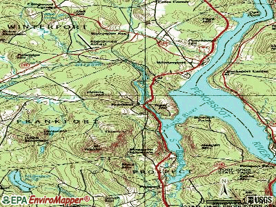
Cemetery: Wiswell Cemetery (1). Display/hide its location on the map
Reservoir: Marsh Stream Reservoir (A). Display/hide its location on the map
Streams, rivers, and creeks: Littlefield Brook (A), Marsh Stream (B), Meadow Brook (C), North Branch Marsh River (D). Display/hide their locations on the map
| This town: | 2.5 people |
| Maine: | 2.3 people |
| This town: | 71.5% |
| Whole state: | 62.9% |
| This town: | 11.9% |
| Whole state: | 9.4% |
Likely homosexual households (counted as self-reported same-sex unmarried-partner households)
- Lesbian couples: 0.4% of all households
- Gay men: 0.9% of all households
| This town: | 13.4% |
| Whole state: | 10.9% |
| This town: | 3.3% |
| Whole state: | 4.1% |
For population 15 years and over in Frankfort:

- Never married: 19.9%
- Now married: 63.9%
- Separated: 0.0%
- Widowed: 5.0%
- Divorced: 11.2%
For population 25 years and over in Frankfort:
- High school or higher: 82.7%
- Bachelor's degree or higher: 14.9%
- Graduate or professional degree: 6.1%
- Unemployed: 6.8%
- Mean travel time to work (commute): 33.4 minutes


| Here: | 9.7 |
| Maine average: | 11.2 |
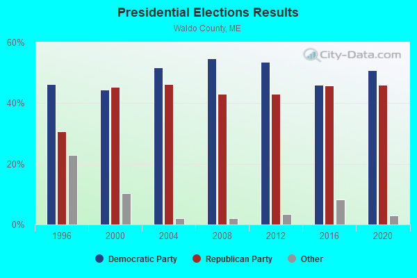
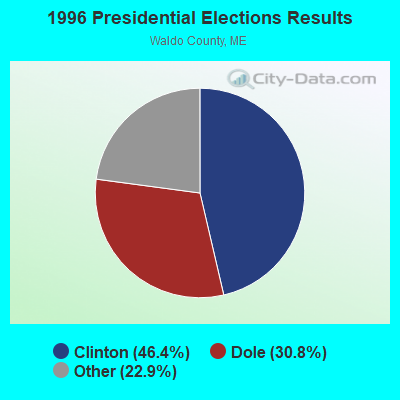
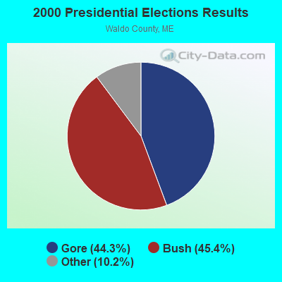
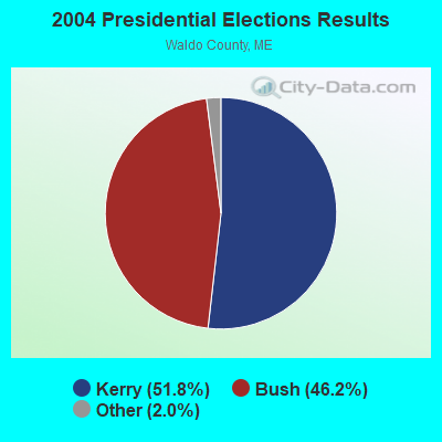
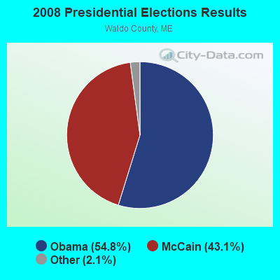
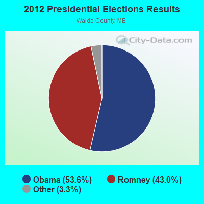
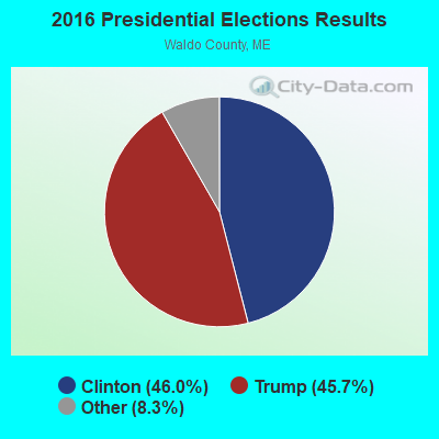
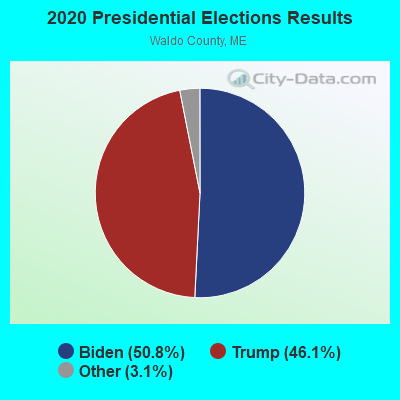
Graphs represent county-level data. Detailed 2008 Election Results
Religion statistics for Frankfort, ME (based on Waldo County data)
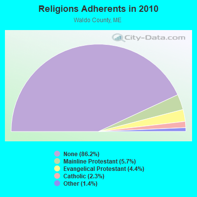
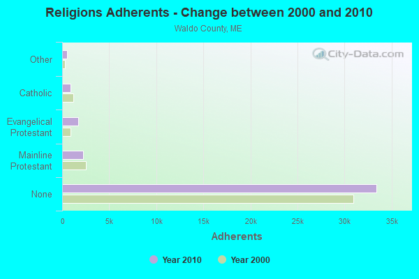
| Religion | Adherents | Congregations |
|---|---|---|
| Mainline Protestant | 2,204 | 20 |
| Evangelical Protestant | 1,711 | 23 |
| Catholic | 900 | 3 |
| Other | 554 | 7 |
| None | 33,417 | - |
Food Environment Statistics:
| Waldo County: | 2.60 / 10,000 pop. |
| State: | 2.80 / 10,000 pop. |
| Here: | 1.82 / 10,000 pop. |
| Maine: | 2.20 / 10,000 pop. |
| This county: | 7.02 / 10,000 pop. |
| Maine: | 5.75 / 10,000 pop. |
| Waldo County: | 8.84 / 10,000 pop. |
| Maine: | 11.02 / 10,000 pop. |
| Here: | 9.2% |
| Maine: | 8.2% |
| Here: | 26.1% |
| Maine: | 25.0% |
Strongest AM radio stations in Frankfort:
- WZON (620 AM; 5 kW; BANGOR, ME; Owner: THE ZONE CORPORATION)
- WABI (910 AM; 5 kW; BANGOR, ME; Owner: CLEAR CHANNEL BROADCASTING LICENSES, INC.)
- WDEA (1370 AM; 5 kW; ELLSWORTH, ME; Owner: CUMULUS LICENSING CORP.)
- WSKW (1160 AM; 10 kW; SKOWHEGAN, ME; Owner: MOUNTAIN WIRELESS, INCORPORATED)
- WRKO (680 AM; 50 kW; BOSTON, MA; Owner: ENTERCOM BOSTON LICENSE, LLC)
- WTME (780 AM; 10 kW; RUMFORD, ME; Owner: MOUNTAIN VALLEY BROADCASTING, INC.)
- WNZS (1340 AM; 1 kW; VEAZIE, ME; Owner: WATERFRONT COMMUNICATIONS INC.)
- WFAU (1280 AM; 5 kW; GARDINER, ME; Owner: CAPSTAR TX LIMITED PARTNERSHIP)
- WEEI (850 AM; 50 kW; BOSTON, MA; Owner: ENTERCOM BOSTON LICENSE, LLC)
- WBZ (1030 AM; 50 kW; BOSTON, MA; Owner: INFINITY BROADCASTING OPERATIONS, INC.)
- WCRN (830 AM; 50 kW; WORCESTER, MA; Owner: CARTER BROADCASTING CORPORATION)
- WNNZ (640 AM; 50 kW; WESTFIELD, MA; Owner: CLEAR CHANNEL BROADCASTING LICENSES, INC.)
- WMTW (870 AM; 10 kW; GORHAM, ME; Owner: RADIO PARTNERS OF MAINE, L.P.)
Strongest FM radio stations in Frankfort:
- WBFB (104.7 FM; BELFAST, ME; Owner: CLEAR CHANNEL BROADCASTING LICENSES, INC.)
- WWBX (97.1 FM; BANGOR, ME; Owner: CLEAR CHANNEL BROADCASTING LICENSES, INC.)
- WKIT-FM (100.3 FM; BREWER, ME; Owner: THE ZONE CORPORATION)
- WFZX (101.7 FM; SEARSPORT, ME; Owner: CLEAR CHANNEL BROADCASTING LICENSES, INC.)
- WWMJ (95.7 FM; ELLSWORTH, ME; Owner: CUMULUS LICENSING CORP.)
- WERU-FM (89.9 FM; BLUE HILL, ME; Owner: SALT POND COMMUNITY B/C COMPANY)
- WMEH (90.9 FM; BANGOR, ME; Owner: MAINE PUBLIC BROADCASTING CORPORATION)
- WEZQ (92.9 FM; BANGOR, ME; Owner: CUMULUS LICENSING CORP.)
- WMEP (90.5 FM; CAMDEN, ME; Owner: MAINE PUBLIC BROADCASTING CORP.)
- WQSS (102.5 FM; CAMDEN, ME; Owner: CLEAR CHANNEL BROADCASTING LICENSES, INC.)
- WVOM (103.9 FM; HOWLAND, ME; Owner: CLEAR CHANNEL BROADCASTING LICENSES, INC.)
- WHCF (88.5 FM; BANGOR, ME; Owner: BANGOR BAPTIST CHURCH)
- WQCB (106.5 FM; BREWER, ME; Owner: CUMULUS LICENSING CORP.)
- WNSX (97.7 FM; WINTER HARBOR, ME; Owner: CLEAR CHANNEL BROADCASTING LICENSES, INC.)
- WMCM (103.3 FM; ROCKLAND, ME; Owner: CLEAR CHANNEL BROADCASTING LICENSES, INC.)
- WBZN (107.3 FM; OLD TOWN, ME; Owner: CUMULUS LICENSING CORP.)
- WGUY (102.1 FM; DEXTER, ME; Owner: CONCORD MEDIA GROUP, INC.)
- WLKE (99.1 FM; BAR HARBOR, ME; Owner: CLEAR CHANNEL BROADCASTING LICENSES, INC.)
- WBYA (105.5 FM; ISLESBORO, ME; Owner: MARINER BROADCASTING LIMTED PARTNERSHIP)
TV broadcast stations around Frankfort:
- WABI-TV (Channel 5; BANGOR, ME; Owner: COMMUNITY BROADCASTING SERVICE)
- WCKD-LP (Channel 30; BANGOR/DEDHAM, ME; Owner: J. MCLEOD, ME FAMILY B/CING., INC.)
- W36CK (Channel 36; BANGOR, ME; Owner: TRINITY BROADCASTING NETWORK)
- WLBZ (Channel 2; BANGOR, ME; Owner: PACIFIC AND SOUTHERN COMPANY, INC.)
- WBGR-LP (Channel 33; BANGOR/DEDHAM, ME; Owner: MAINE FAMILY BROADCASTING, INC.)
- WMEB-TV (Channel 12; ORONO, ME; Owner: MAINE PUBLIC BROADCASTING CORPORATION)
- W66CL (Channel 66; BANGOR, ME; Owner: MS COMMUNICATIONS, LLC)
- Frankfort, Maine
- Fatal accident count13
- Vehicles involved in fatal accidents17
- Fatal accidents involving drunk persons:5
- Fatalities15
- Persons involved in fatal accidents23
- Pedestrians involved in fatal accidents0
- Maine average
- Fatal accident count1731
- Vehicles involved in fatal accidents2481
- Fatal accidents involving drunk persons702
- Fatalities1934
- Persons involved in fatal accidents4086
- Pedestrians involved in fatal accidents149
- National Bridge Inventory (NBI) Statistics
- 7Number of bridges
- 66ft / 20.3mTotal length
- 24,771Total average daily traffic
- 1,238Total average daily truck traffic
- 35,479Total future (year 2034) average daily traffic
FCC Registered Cell Phone Towers:
1 (See the full list of FCC Registered Cell Phone Towers in Frankfort)FCC Registered Antenna Towers:
16 (See the full list of FCC Registered Antenna Towers)FCC Registered Broadcast Land Mobile Towers:
3- Mt Waldo (Lat: 44.580917 Lon: -68.895861), Type: Gtower, Structure height: 60 m, Call Sign: WPXL919,
Assigned Frequencies: 154.250 MHz, Grant Date: 02/22/2023, Expiration Date: 05/01/2033, Certifier: Robert B Mckenney, Registrant: Browns Communications, 162 Bangor Road, Ellsworth, ME 04605, Phone: (207) 667-2254, Fax: (207) 667-6335, Email:
- Mt Waldo (Lat: 44.580917 Lon: -68.895861), Type: Gtower, Structure height: 60 m, Call Sign: WQAQ315,
Assigned Frequencies: 155.055 MHz, 159.180 MHz, Grant Date: 04/29/2014, Expiration Date: 07/19/2024, Certifier: Linda S Dunno, Registrant: Browns Communications Inc, 162 Bangor Road, Ellsworth, ME 04605, Phone: (207) 667-2254, Fax: (207) 667-6335, Email:
- MT WALDO, Off Tyler Lane (Lat: 44.580278 Lon: -68.895194), Type: Gtower, Structure height: 44.2 m, Call Sign: WRPB892,
Assigned Frequencies: 155.385 MHz, 156.187 MHz, 156.030 MHz, 154.732 MHz, Grant Date: 01/13/2022, Expiration Date: 01/13/2032, Certifier: Michael Larrivee, Registrant: Radio Communications Management Inc., 158 Rand Rd, Rcm, Portland, ME 04102, Phone: (207) 797-7503, Email:
FCC Registered Microwave Towers:
7- Mt Waldo, Atop Mount Waldo (Lat: 44.580833 Lon: -68.896944), Type: Tower, Structure height: 85 m, Overall height: 86 m, Call Sign: WPJC767,
Assigned Frequencies: 6565.00 MHz, Grant Date: 11/11/2020, Expiration Date: 01/11/2031, Registrant: Utilities Technology Council, 2550 South Clark St., Suite 960, Arlington, VA 22202, Phone: (202) 872-0030, Fax: (202) 872-1331, Email:
- FRANKFORT, 32 Windy Hill Lane (Lat: 44.578083 Lon: -68.981111), Type: Gtower, Structure height: 59.4 m, Overall height: 60.7 m, Call Sign: WQVD737,
Assigned Frequencies: 6389.96 MHz, Grant Date: 01/12/2015, Expiration Date: 01/12/2025, Certifier: Steven T Campbell, Registrant: Wilkinson Barker Knauer, LLP, 1800 M Street Nw, Suite 800n, Washington, DC 20036, Phone: (202) 383-3420, Fax: (202) 783-5851, Email:
- FRANKFORT, Town Farm Hill (Lat: 44.577556 Lon: -68.980556), Type: Ltower, Structure height: 33 m, Call Sign: WQYD975,
Assigned Frequencies: 959.600 MHz, Grant Date: 08/29/2016, Expiration Date: 08/29/2026, Certifier: Owen Smith, Registrant: Waldo County Emergency Management Agency, 4 Public Safety Way, Belfast, ME 04915, Phone: (207) 338-3870, Fax: (207) 338-1890, Email:
- Mount Waldo, Atop Mount Waldo (Lat: 44.580833 Lon: -68.896944), Type: Ltower, Structure height: 85 m, Overall height: 86 m, Call Sign: WRCQ683,
Assigned Frequencies: 10835.0 MHz, 11325.0 MHz, 10835.0 MHz, 11325.0 MHz, 10835.0 MHz, 11325.0 MHz, 10835.0 MHz, 11325.0 MHz, 10835.0 MHz, 11325.0 MHz... (+6 more), Grant Date: 12/07/2018, Expiration Date: 12/07/2028, Certifier: Mark Mcpherson, Registrant: Micronet Communications, Inc., 812 Lexington Dr, Plano, TX 75075, Phone: (972) 422-7200, Email:
- 4BG0487A, Eastern Road (Lat: 44.607639 Lon: -68.862389), Type: Ltower, Structure height: 76.2 m, Overall height: 78.6 m, Call Sign: WREJ578,
Assigned Frequencies: 11385.0 MHz, 11385.0 MHz, 11385.0 MHz, 11385.0 MHz, 11385.0 MHz, 11385.0 MHz, 11385.0 MHz, 11385.0 MHz, Grant Date: 10/16/2019, Expiration Date: 10/16/2029, Cancellation Date: 08/21/2023, Certifier: David Werblow, Registrant: T-Mobile Usa, Inc., 12920 Se 38th Street, Bellevue, WA 98006, Phone: (425) 383-8401, Fax: (425) 383-4040, Email:
- Mount Waldo, Atop Mount Waldo (Lat: 44.580833 Lon: -68.896944), Type: Ltower, Structure height: 85 m, Overall height: 86 m, Call Sign: WREW354,
Assigned Frequencies: 10995.0 MHz, 10995.0 MHz, 10995.0 MHz, 10995.0 MHz, 10995.0 MHz, 10995.0 MHz, 10995.0 MHz, 10995.0 MHz, Grant Date: 12/12/2019, Expiration Date: 12/12/2029, Certifier: Jim Mckenna, Registrant: Intelpath, Hinsdale, IL 60522, Phone: (312) 841-9188, Email:
- WALDO MTN, Atop Mount Waldo (Lat: 44.580833 Lon: -68.896944), Type: Ltower, Structure height: 85 m, Overall height: 86 m, Call Sign: WRVS849,
Assigned Frequencies: 6615.00 MHz, 6615.00 MHz, 6615.00 MHz, 6615.00 MHz, 6615.00 MHz, 6615.00 MHz, 6615.00 MHz, 6615.00 MHz, Grant Date: 01/03/2023, Expiration Date: 01/03/2033, Certifier: Michael Larrivee, Registrant: Radio Communications Management Inc., 158 Rand Road, Rcm, Portland, ME 04102, Phone: (207) 797-7503, Email:
FCC Registered Amateur Radio Licenses:
5- Call Sign: KB1EYD, Licensee ID: L00221285, Grant Date: 03/23/2000, Expiration Date: 03/23/2010, Cancellation Date: 03/24/2012, Certifier: Vicki L Baack, Registrant: Vicki L Baack, 5 Lily Ln, Frankfort, ME 04438
- Call Sign: KB1GUS, Licensee ID: L00357923, Grant Date: 05/17/2001, Expiration Date: 05/17/2011, Cancellation Date: 07/30/2002, Certifier: Jason K Baack, Registrant: Caribou Me Nwsfo Skywarn, 5 Lily Lane, Frankfort, ME 04438
- Call Sign: KB1NDI, Licensee ID: L01122115, Grant Date: 02/11/2016, Expiration Date: 02/24/2026, Certifier: Joseph A Fabian Jr, Registrant: Joseph A Fabian Jr, 345 Marsh Stream Rd, Frankfort, ME 04438
- Call Sign: KB1NKH, Licensee ID: L01138141, Grant Date: 02/23/2016, Expiration Date: 04/07/2026, Certifier: Marcia L Vertefeuille, Registrant: Marcia L Vertefeuille, 345 Marsh Stream Rd, Frankfort, ME 04438
- Call Sign: KC1JGS, Licensee ID: L02170109, Grant Date: 03/15/2018, Expiration Date: 03/15/2028, Certifier: Miles A Mertin, Registrant: Miles A Mertin, 182 Tylerlane, Frankfort, ME 04438
FAA Registered Aircraft:
2- Aircraft: MOONEY M20J (Category: Land, Seats: 4, Weight: Up to 12,499 Pounds, Speed: 126 mph), Engine: LYCOMING I0360 SER (180 HP) (Reciprocating)
N-Number: 201XR, N201XR, N-201XR, Serial Number: 24-0502, Year manufactured: 1978, Airworthiness Date: 03/16/1978, Certificate Issue Date: 04/02/2015
Registrant (Individual): Kenneth A Lavin, Po Box 32, Frankfort, ME 04438 - Aircraft: CESSNA 182N (Category: Land, Seats: 4, Weight: Up to 12,499 Pounds, Speed: 119 mph), Engine: CONT MOTOR O-470 SERIES (230 HP) (Reciprocating)
N-Number: 9169G, N9169G, N-9169G, Serial Number: 18260709, Year manufactured: 1971, Airworthiness Date: 07/21/1971, Certificate Issue Date: 03/02/2019
Registrant (Individual): Joshua O Dickson, 143 W Hill Rd, Frankfort, ME 04438
2004 - 2018 National Fire Incident Reporting System (NFIRS) incidents
- Fire incident types reported to NFIRS in Frankfort, ME
- 7058.3%Structure Fires
- 4033.3%Outside Fires
- 97.5%Mobile Property/Vehicle Fires
- 10.8%Other
 Based on the data from the years 2004 - 2018 the average number of fire incidents per year is 8. The highest number of reported fires - 14 took place in 2007, and the least - 2 in 2012. The data has a declining trend.
 When looking into fire subcategories, the most reports belonged to: Structure Fires (58.3%), and Outside Fires (33.3%).
- 73.9%Fuel oil, kerosene, etc.
- 19.8%Wood
- 4.6%Bottled, tank, or LP gas
- 1.1%Electricity
- 0.6%Other fuel

- 78.8%Fuel oil, kerosene, etc.
- 15.4%Wood
- 5.8%Electricity
Frankfort compared to Maine state average:
- Unemployed percentage below state average.
- Black race population percentage significantly below state average.
- Hispanic race population percentage significantly below state average.
- Foreign-born population percentage significantly below state average.
- Renting percentage below state average.
- Length of stay since moving in significantly above state average.
- Number of rooms per house significantly below state average.
- House age significantly below state average.
- Percentage of population with a bachelor's degree or higher below state average.