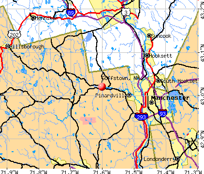
Goffstown, New Hampshire
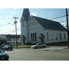
Goffstown: First Congregational - The oldest church in town
Goffstown: Town Hall
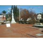
Goffstown: Rotary Club Park
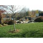
Goffstown: Town Common Park
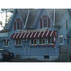
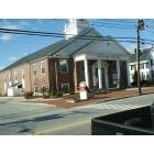
Goffstown: Putnam's Restaurant - Fine eating in Goffstown
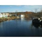
Goffstown: Piscataquog River

Goffstown: The river beneath Main Street bridge
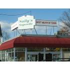
Goffstown: Sully's Superette - Where to shop in Goffstown
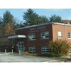
Goffstown: Maple Avenue Elementary School
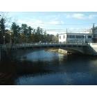
Goffstown: Main Street bridge
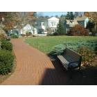
Goffstown: Town Common Park pathway
- see
14
more - add
your


Submit your own pictures of this town and show them to the world
- OSM Map
- General Map
- Google Map
- MSN Map
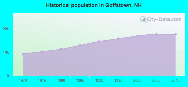
Population change since 2000: +4.3%
 |
| Males: 8,344 | |
| Females: 9,307 |
| Median resident age: | 39.0 years |
| New Hampshire median age: | 43.9 years |
Zip codes: 03045.
| Goffstown: | $101,367 |
| NH: | $89,992 |
Estimated per capita income in 2022: $43,689 (it was $21,907 in 2000)
Goffstown town income, earnings, and wages data
Estimated median house or condo value in 2022: $364,494 (it was $121,200 in 2000)
| Goffstown: | $364,494 |
| NH: | $384,700 |
Mean prices in 2022: all housing units: $411,252; detached houses: $441,251; townhouses or other attached units: $283,002; in 2-unit structures: $347,377; in 3-to-4-unit structures: $666,663; in 5-or-more-unit structures: $275,798; mobile homes: $132,093
Detailed information about poverty and poor residents in Goffstown, NH


Compare current foreclosures near Goffstown, NH:
| Photo | Address | Area | Beds / Baths | Price | Details |
|---|---|---|---|---|---|

|
#1
Portage Rd
Goffstown, NH 03045
|
1,344 sq. feet
|
2 baths 3 beds |
show details | |

|
#2
Wallace Rd
Goffstown, NH 03045
|
1,848 sq. feet
|
1 baths 2 beds |
show details | |

|
#3
Moose Club Park Rd
Goffstown, NH 03045
|
1,864 sq. feet
|
2 baths 4 beds |
show details | |

|
#4
Diamond Ln
Goffstown, NH 03045
|
2,464 sq. feet
|
1 baths 4 beds |
show details | |

|
#5
Longbrook Rd
Goffstown, NH 03045
|
1,960 sq. feet
|
2 baths 3 beds |
show details | |

|
#6
Channel Ln
Goffstown, NH 03045
|
812 sq. feet
|
1 baths 2 beds |
show details | |

|
#7
Reed St Apt 105
Goffstown, NH 03045
|
- sq. feet
|
- baths - beds |
show details | |

|
#8
Foxtail Ln Apt 2
Goffstown, NH 03045
|
- sq. feet
|
- baths - beds |
show details | |

|
#9
Roger Rd
Goffstown, NH 03045
|
- sq. feet
|
- baths - beds |
show details | |

|
#10
Blucher St
Manchester, NH 03102
|
2,448 sq. feet
|
2 baths 3 beds |
show details |
| Photo | Address | Area | Beds / Baths | Price | Details |
|---|---|---|---|---|---|

|
#11
Juniper Dr
Amherst, NH 03031
|
3,364 sq. feet
|
4 baths 4 beds |
show details | |

|
#12
Amherst St
Amherst, NH 03031
|
- sq. feet
|
4 baths 3 beds |
show details | |

|
#13
Fieldstone Dr
Amherst, NH 03031
|
2,280 sq. feet
|
3 baths 3 beds |
show details | |

|
#14
High St
Derry, NH 03038
|
2,149 sq. feet
|
3 baths 4 beds |
show details | |

|
#15
Brook St
Derry, NH 03038
|
1,476 sq. feet
|
2 baths 4 beds |
show details | |

|
#16
Donati Dr
Hooksett, NH 03106
|
2,269 sq. feet
|
3 baths 5 beds |
show details | |

|
#17
Elm St
Manchester, NH 03104
|
4,352 sq. feet
|
3 baths 3 beds |
show details | |

|
#18
Portsmouth St
Concord, NH 03301
|
1,184 sq. feet
|
2 baths 3 beds |
show details | |

|
#19
N State St
Concord, NH 03301
|
1,920 sq. feet
|
1 baths 3 beds |
show details | |

|
#20
Walnut Hill Rd
Derry, NH 03038
|
2,042 sq. feet
|
2 baths 3 beds |
show details |
| Photo | Address | Area | Beds / Baths | Price | Details |
|---|---|---|---|---|---|

|
#21
Tsienneto Rd Unit 39
Derry, NH 03038
|
1,936 sq. feet
|
1 baths 2 beds |
show details | |

|
#22
Wedgewood Cir Unit 9
Hooksett, NH 03106
|
1,942 sq. feet
|
2 baths 2 beds |
show details | |

|
#23
Revere Ave
Manchester, NH 03109
|
3,240 sq. feet
|
2 baths 2 beds |
show details | |

|
#24
Lucille St
Manchester, NH 03103
|
1,425 sq. feet
|
2 baths 4 beds |
show details | |

|
#25
Lawrence St
Derry, NH 03038
|
2,124 sq. feet
|
2 baths 3 beds |
show details | |

|
#26
Delaware Ave # 1
Manchester, NH 03104
|
2,946 sq. feet
|
3 baths 8 beds |
show details | |

|
#27
Whitehall Rd
Hooksett, NH 03106
|
2,740 sq. feet
|
2 baths 5 beds |
show details | |

|
#28
Normand St
Manchester, NH 03109
|
1,502 sq. feet
|
2 baths 3 beds |
show details | |

|
#29
Pinnacle St
Hooksett, NH 03106
|
2,238 sq. feet
|
2 baths 3 beds |
show details | |

|
#30
Auburn Rd
Hooksett, NH 03106
|
1,800 sq. feet
|
2 baths 3 beds |
show details |
| Photo | Address | Area | Beds / Baths | Price | Details |
|---|---|---|---|---|---|

|
#31
Westwood Dr
Manchester, NH 03103
|
2,086 sq. feet
|
1 baths 3 beds |
show details | |

|
#32
Wells St
Manchester, NH 03104
|
2,800 sq. feet
|
1 baths 3 beds |
show details | |

|
#33
Van Ger Dr
Bow, NH 03304
|
2,498 sq. feet
|
2 baths 3 beds |
show details | |

|
#34
Brown Ave
Manchester, NH 03103
|
1,296 sq. feet
|
1 baths 4 beds |
show details | |

|
#35
Tenney Hill Rd
Dunbarton, NH 03046
|
1,906 sq. feet
|
1 baths 2 beds |
show details | |

|
#36
Beech Hill Ave
Manchester, NH 03103
|
1,596 sq. feet
|
1 baths 2 beds |
show details | |

|
#37
Etta Ln
Weare, NH 03281
|
1,425 sq. feet
|
1 baths 3 beds |
show details | |

|
#38
Pinard St
Manchester, NH 03102
|
2,028 sq. feet
|
2 baths 5 beds |
show details | |

|
#39
Northfield Rd
Amherst, NH 03031
|
1,688 sq. feet
|
1 baths 3 beds |
show details | |

|
#40
Bypass 28
Derry, NH 03038
|
2,300 sq. feet
|
2 baths 4 beds |
show details |
| Photo | Address | Area | Beds / Baths | Price | Details |
|---|---|---|---|---|---|

|
#41
Courthouse Rd
Amherst, NH 03031
|
1,391 sq. feet
|
1 baths 3 beds |
show details | |

|
#42
S Fruit St
Concord, NH 03301
|
1,768 sq. feet
|
2 baths 4 beds |
show details | |

|
#43
Wiley Hill Rd
Londonderry, NH 03053
|
2,668 sq. feet
|
2 baths 3 beds |
show details | |

|
#44
Pine Blf # 3
Derry, NH 03038
|
1,872 sq. feet
|
2 baths 3 beds |
show details | |

|
#45
Cypress Rd
Milford, NH 03055
|
1,929 sq. feet
|
1 baths 3 beds |
show details | |

|
#46
Cross Country Rd
Suncook, NH 03275
|
- sq. feet
|
1 baths 3 beds |
show details | |

|
#47
Pine Bluf 3
Derry, NH 03038
|
1,872 sq. feet
|
2 baths 3 beds |
show details | |

|
#48
Scenic Dr
Derry, NH 03038
|
1,692 sq. feet
|
1 baths 2 beds |
show details | |

|
#49
Megan Dr
Manchester, NH 03109
|
2,244 sq. feet
|
1 baths 3 beds |
show details | |

|
Check over 1 million property listings on Foreclosure.com!
|
browse all offers | |||


- 16,81395.3%White alone
- 3221.8%Hispanic
- 1871.1%Two or more races
- 1410.8%Black alone
- 1420.8%Asian alone
- 230.1%American Indian alone
- 180.1%Other race alone
- 50.03%Native Hawaiian and Other
Pacific Islander alone
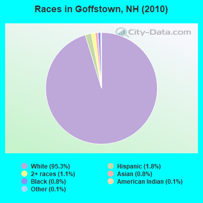
Races in Goffstown detailed stats: ancestries, foreign born residents, place of birth
According to our research of New Hampshire and other state lists, there were 19 registered sex offenders living in Goffstown, New Hampshire as of May 11, 2024.
The ratio of all residents to sex offenders in Goffstown is 929 to 1.
The ratio of registered sex offenders to all residents in this city is lower than the state average.
Type |
2009 |
2010 |
2011 |
2012 |
2013 |
2014 |
2015 |
2016 |
2017 |
2018 |
2019 |
2020 |
2021 |
2022 |
|---|---|---|---|---|---|---|---|---|---|---|---|---|---|---|
| Murders (per 100,000) | 0 (0.0) | 0 (0.0) | 0 (0.0) | 0 (0.0) | 0 (0.0) | 0 (0.0) | 0 (0.0) | 0 (0.0) | 1 (5.5) | 0 (0.0) | 1 (5.5) | 0 (0.0) | 0 (0.0) | 0 (0.0) |
| Rapes (per 100,000) | 0 (0.0) | 2 (11.3) | 1 (5.7) | 1 (5.6) | 1 (5.6) | 2 (11.2) | 7 (38.8) | 9 (50.0) | 8 (44.3) | 6 (33.4) | 9 (49.6) | 6 (33.2) | 11 (60.5) | 6 (32.7) |
| Robberies (per 100,000) | 3 (17.0) | 1 (5.7) | 2 (11.3) | 2 (11.3) | 5 (28.2) | 4 (22.4) | 3 (16.6) | 3 (16.7) | 4 (22.2) | 2 (11.1) | 4 (22.0) | 2 (11.1) | 4 (22.0) | 1 (5.4) |
| Assaults (per 100,000) | 7 (39.7) | 7 (39.7) | 11 (62.2) | 5 (28.2) | 7 (39.5) | 16 (89.7) | 12 (66.5) | 22 (122.2) | 23 (127.4) | 17 (94.6) | 4 (22.0) | 3 (16.6) | 4 (22.0) | 10 (54.4) |
| Burglaries (per 100,000) | 42 (238.2) | 87 (492.9) | 84 (475.3) | 48 (270.8) | 58 (327.3) | 46 (257.9) | 67 (371.2) | 59 (327.8) | 21 (116.3) | 12 (66.7) | 13 (71.6) | 6 (33.2) | 10 (55.0) | 6 (32.7) |
| Thefts (per 100,000) | 253 (1,435) | 216 (1,224) | 230 (1,301) | 201 (1,134) | 290 (1,636) | 216 (1,211) | 216 (1,197) | 158 (877.8) | 146 (808.6) | 111 (617.4) | 98 (539.6) | 105 (580.2) | 100 (549.9) | 106 (576.9) |
| Auto thefts (per 100,000) | 7 (39.7) | 5 (28.3) | 2 (11.3) | 2 (11.3) | 7 (39.5) | 7 (39.2) | 12 (66.5) | 3 (16.7) | 13 (72.0) | 13 (72.3) | 3 (16.5) | 5 (27.6) | 14 (77.0) | 6 (32.7) |
| Arson (per 100,000) | 2 (11.3) | 3 (17.0) | 0 (0.0) | 0 (0.0) | 0 (0.0) | 1 (5.6) | 1 (5.5) | 2 (11.1) | 0 (0.0) | 0 (0.0) | 0 (0.0) | 1 (5.5) | 0 (0.0) | 2 (10.9) |
| City-Data.com crime index | 90.3 | 104.4 | 106.6 | 78.8 | 112.4 | 103.3 | 128.5 | 128.8 | 124.9 | 84.1 | 89.6 | 60.9 | 91.4 | 66.6 |
The City-Data.com crime index weighs serious crimes and violent crimes more heavily. Higher means more crime, U.S. average is 246.1. It adjusts for the number of visitors and daily workers commuting into cities.
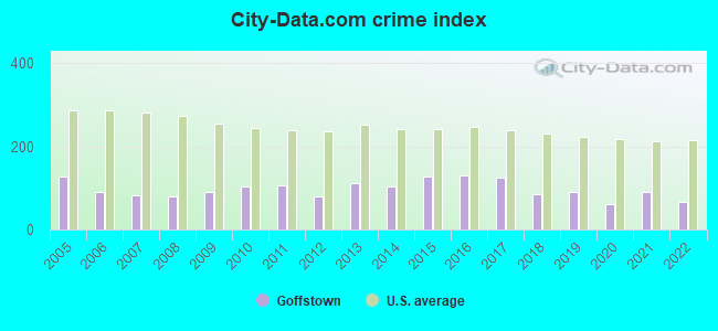
Crime rate in Goffstown detailed stats: murders, rapes, robberies, assaults, burglaries, thefts, arson
Full-time law enforcement employees in 2021, including police officers: 45 (31 officers - 25 male; 6 female).
| Officers per 1,000 residents here: | 1.70 |
| New Hampshire average: | 2.14 |
 Recent articles from our blog. Our writers, many of them Ph.D. graduates or candidates, create easy-to-read articles on a wide variety of topics.


 | What's life like in Goffstown,NH? (2 replies) |
| Please tell me about Goffstown (15 replies) |
| Durham, Dover, Hampton, Salem, Laconia, Keene, Goffstown . . . Oh, my! (12 replies) |
| Workshop for Granite state future? (Sat 4/13) Bedford/Goffstown planning (7 replies) |
| Oregon to NH (42 replies) |
| Doggy Daycare Goffstown (5 replies) |
Latest news from Goffstown, NH collected exclusively by city-data.com from local newspapers, TV, and radio stations
Ancestries: Irish (20.6%), French Canadian (19.5%), French (15.9%), English (15.4%), German (9.1%), Italian (7.6%).
Current Local Time: EST time zone
Incorporated in 1761
Elevation: 306 feet
Land area: 36.9 square miles.
Population density: 478 people per square mile (low).
540 residents are foreign born (1.9% North America, 0.5% Europe, 0.4% Latin America, 0.3% Asia).
| This town: | 3.2% |
| New Hampshire: | 4.4% |
| Goffstown town: | 2.7% ($3,226) |
| New Hampshire: | 2.3% ($2,946) |
Nearest city with pop. 50,000+: Manchester, NH  (5.3 miles , pop. 107,006).
Nearest city with pop. 200,000+: Boston, MA (53.3 miles , pop. 589,141).
Nearest city with pop. 1,000,000+: Bronx, NY (191.7 miles , pop. 1,332,650).
Nearest cities:
), ), ), )Latitude: 43.01 N, Longitude: 71.55 W
Area code: 603


Goffstown, New Hampshire accommodation & food services, waste management - Economy and Business Data
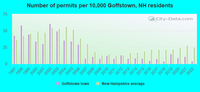
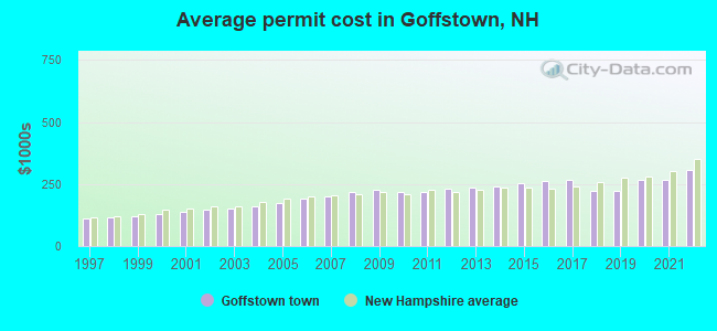
Single-family new house construction building permits:
- 2022: 7 buildings, average cost: $308,200
- 2021: 19 buildings, average cost: $264,600
- 2020: 16 buildings, average cost: $265,300
- 2019: 26 buildings, average cost: $224,000
- 2018: 7 buildings, average cost: $221,300
- 2017: 13 buildings, average cost: $267,400
- 2016: 9 buildings, average cost: $261,200
- 2015: 14 buildings, average cost: $254,900
- 2014: 15 buildings, average cost: $238,900
- 2013: 14 buildings, average cost: $234,100
- 2012: 23 buildings, average cost: $231,000
- 2011: 14 buildings, average cost: $219,700
- 2010: 21 buildings, average cost: $217,000
- 2009: 14 buildings, average cost: $224,600
- 2008: 19 buildings, average cost: $219,400
- 2007: 14 buildings, average cost: $201,900
- 2006: 50 buildings, average cost: $192,100
- 2005: 58 buildings, average cost: $174,600
- 2004: 60 buildings, average cost: $160,900
- 2003: 84 buildings, average cost: $152,000
- 2002: 103 buildings, average cost: $146,000
- 2001: 52 buildings, average cost: $138,200
- 2000: 58 buildings, average cost: $128,700
- 1999: 76 buildings, average cost: $121,600
- 1998: 99 buildings, average cost: $116,200
- 1997: 73 buildings, average cost: $112,300
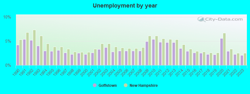
| Here: | 2.1% |
| New Hampshire: | 2.5% |
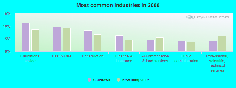
- Educational services (11.2%)
- Health care (9.8%)
- Construction (8.4%)
- Finance & insurance (6.3%)
- Accommodation & food services (4.6%)
- Public administration (4.1%)
- Professional, scientific, technical services (4.1%)
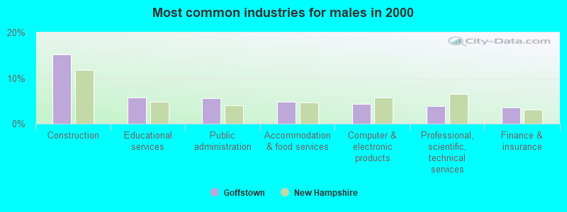
- Construction (15.3%)
- Educational services (5.8%)
- Public administration (5.6%)
- Accommodation & food services (4.8%)
- Computer & electronic products (4.3%)
- Professional, scientific, technical services (3.9%)
- Finance & insurance (3.6%)
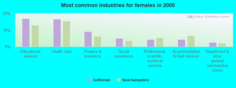
- Educational services (17.1%)
- Health care (16.6%)
- Finance & insurance (9.3%)
- Social assistance (5.1%)
- Professional, scientific, technical services (4.4%)
- Accommodation & food services (4.3%)
- Department & other general merchandise stores (2.7%)
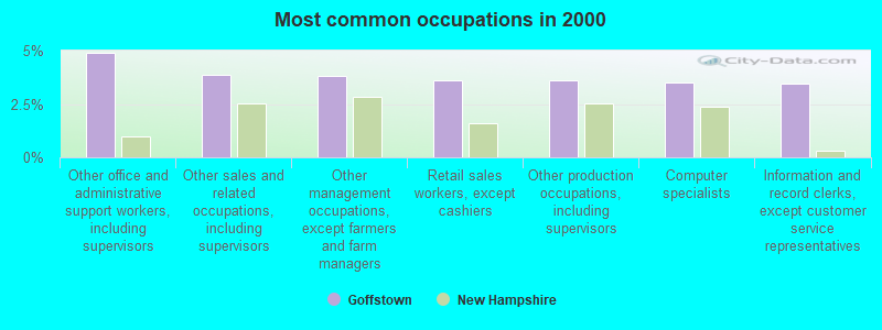
- Other office and administrative support workers, including supervisors (4.9%)
- Other sales and related occupations, including supervisors (3.9%)
- Other management occupations, except farmers and farm managers (3.8%)
- Retail sales workers, except cashiers (3.6%)
- Other production occupations, including supervisors (3.6%)
- Computer specialists (3.5%)
- Information and record clerks, except customer service representatives (3.4%)
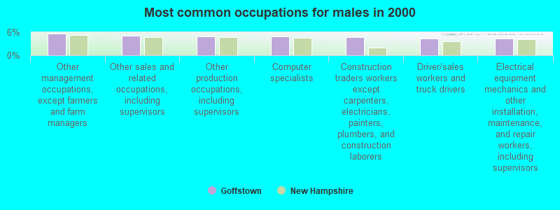
- Other management occupations, except farmers and farm managers (5.7%)
- Other sales and related occupations, including supervisors (5.0%)
- Other production occupations, including supervisors (4.9%)
- Computer specialists (4.9%)
- Construction traders workers except carpenters, electricians, painters, plumbers, and construction laborers (4.7%)
- Driver/sales workers and truck drivers (4.4%)
- Electrical equipment mechanics and other installation, maintenance, and repair workers, including supervisors (4.3%)
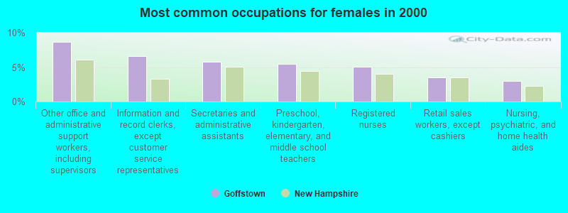
- Other office and administrative support workers, including supervisors (8.6%)
- Information and record clerks, except customer service representatives (6.6%)
- Secretaries and administrative assistants (5.8%)
- Preschool, kindergarten, elementary, and middle school teachers (5.4%)
- Registered nurses (5.1%)
- Retail sales workers, except cashiers (3.6%)
- Nursing, psychiatric, and home health aides (2.9%)
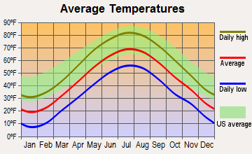
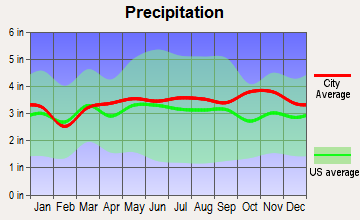
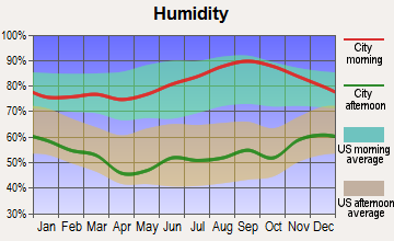
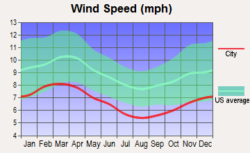
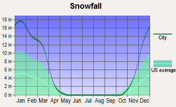
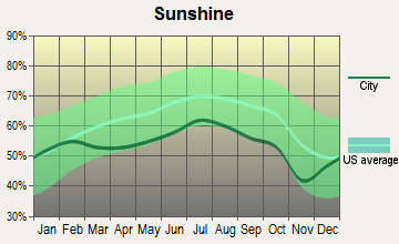
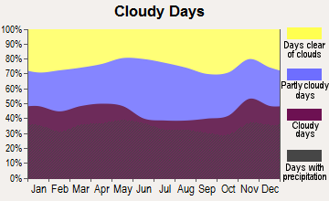
Average climate in Goffstown, New Hampshire
Based on data reported by over 4,000 weather stations
(lower is better)
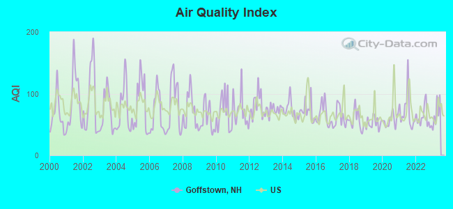
Air Quality Index (AQI) level in 2022 was 60.7. This is about average.
| City: | 60.7 |
| U.S.: | 72.6 |
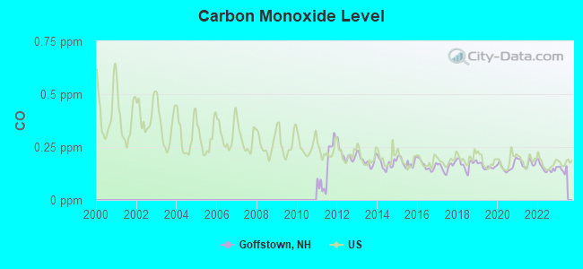
Carbon Monoxide (CO) [ppm] level in 2022 was 0.150. This is significantly better than average. Closest monitor was 4.6 miles away from the city center.
| City: | 0.150 |
| U.S.: | 0.251 |
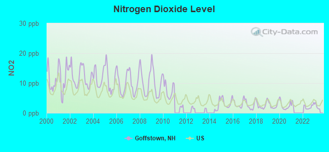
Nitrogen Dioxide (NO2) [ppb] level in 2022 was 2.05. This is significantly better than average. Closest monitor was 4.2 miles away from the city center.
| City: | 2.05 |
| U.S.: | 5.11 |
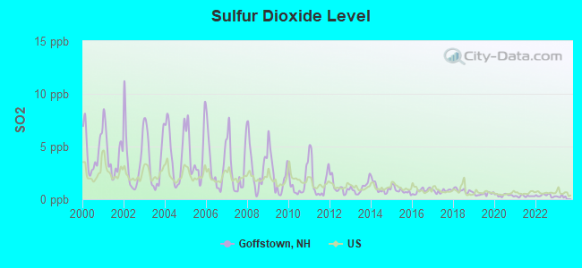
Sulfur Dioxide (SO2) [ppb] level in 2022 was 0.354. This is significantly better than average. Closest monitor was 4.2 miles away from the city center.
| City: | 0.354 |
| U.S.: | 1.515 |
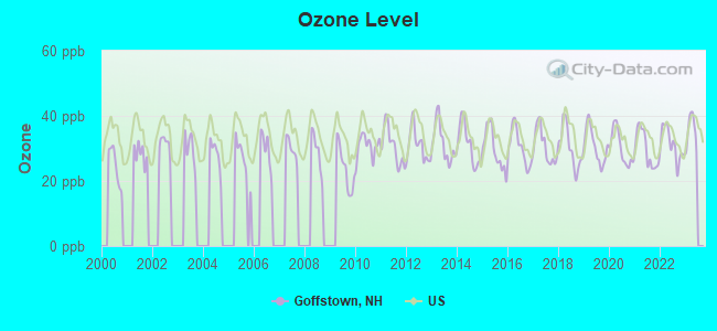
Ozone [ppb] level in 2022 was 31.2. This is about average. Closest monitor was 4.2 miles away from the city center.
| City: | 31.2 |
| U.S.: | 33.3 |
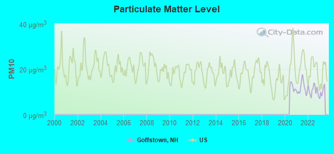
Particulate Matter (PM10) [µg/m3] level in 2022 was 10.6. This is significantly better than average. Closest monitor was 4.2 miles away from the city center.
| City: | 10.6 |
| U.S.: | 19.2 |
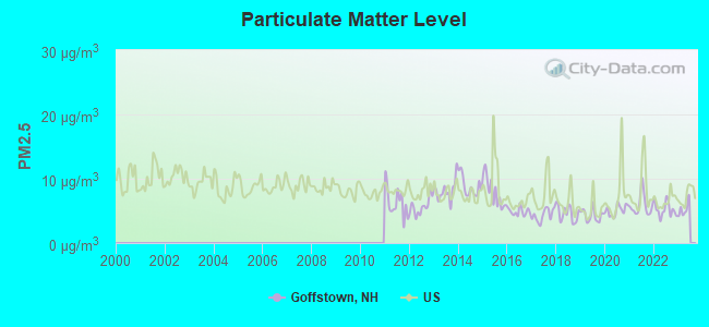
Particulate Matter (PM2.5) [µg/m3] level in 2022 was 5.21. This is significantly better than average. Closest monitor was 4.2 miles away from the city center.
| City: | 5.21 |
| U.S.: | 8.11 |
Tornado activity:
Goffstown-area historical tornado activity is slightly above New Hampshire state average. It is 37% smaller than the overall U.S. average.
On 6/9/1953, a category F3 (max. wind speeds 158-206 mph) tornado 29.5 miles away from the Goffstown town center injured 5 people and caused between $5000 and $50,000 in damages.
On 10/3/1970, a category F3 tornado 30.7 miles away from the town center killed one person and caused between $50,000 and $500,000 in damages.
Earthquake activity:
Goffstown-area historical earthquake activity is significantly above New Hampshire state average. It is 71% smaller than the overall U.S. average.On 4/20/2002 at 10:50:47, a magnitude 5.3 (5.3 ML, Depth: 3.0 mi, Class: Moderate, Intensity: VI - VII) earthquake occurred 149.2 miles away from the city center
On 10/7/1983 at 10:18:46, a magnitude 5.3 (5.1 MB, 5.3 LG, 5.1 ML) earthquake occurred 154.5 miles away from the city center
On 1/19/1982 at 00:14:42, a magnitude 4.7 (4.5 MB, 4.7 MD, 4.5 LG, Class: Light, Intensity: IV - V) earthquake occurred 33.8 miles away from Goffstown center
On 4/20/2002 at 10:50:47, a magnitude 5.2 (5.2 MB, 4.2 MS, 5.2 MW, 5.0 MW) earthquake occurred 148.8 miles away from the city center
On 10/16/2012 at 23:12:25, a magnitude 4.7 (4.7 ML, Depth: 10.0 mi) earthquake occurred 60.5 miles away from Goffstown center
On 10/2/1994 at 11:27:22, a magnitude 3.7 (3.5 LG, 3.7 LG, Depth: 6.2 mi, Class: Light, Intensity: II - III) earthquake occurred 59.1 miles away from the city center
Magnitude types: regional Lg-wave magnitude (LG), body-wave magnitude (MB), duration magnitude (MD), local magnitude (ML), surface-wave magnitude (MS), moment magnitude (MW)
Natural disasters:
The number of natural disasters in Hillsborough County (27) is a lot greater than the US average (15).Major Disasters (Presidential) Declared: 17
Emergencies Declared: 10
Causes of natural disasters: Storms: 13, Floods: 11, Winter Storms: 5, Snowstorms: 4, Hurricanes: 3, Snows: 3, Blizzard: 1, Ice Storm: 1, Snowfall: 1, Wind: 1 (Note: some incidents may be assigned to more than one category).

Hospitals and medical centers in Goffstown:
Other hospitals and medical centers near Goffstown:
- HACKETT HILL HEALTHCARE CENTER (Nursing Home, about 4 miles away; MANCHESTER, NH)
- LAUREL CENTER (Nursing Home, about 4 miles away; BEDFORD, NH)
- COURVILLE AT MANCHESTER (Nursing Home, about 5 miles away; MANCHESTER, NH)
- OLSTEN HEALTH SERVICES (Home Health Center, about 5 miles away; MANCHESTER, NH)
- PEOPLE HELPING PEOPLE INC (Home Health Center, about 5 miles away; MANCHESTER, NH)
- INTERIM HEALTHCARE (Home Health Center, about 5 miles away; MANCHESTER, NH)
- VNA HOME HEALTH AND HOSPICE SERVICES, INC (Home Health Center, about 5 miles away; MANCHESTER, NH)
Airports located in Goffstown:
- Country Club Air Park Airport (NH88) (Runways: 1, Itinerant Ops: 349, Local Ops: 611)
Colleges/universities with over 2000 students nearest to Goffstown:
- Saint Anselm College (about 3 miles; Manchester, NH; Full-time enrollment: 2,059)
- Mount Washington College (about 5 miles; Manchester, NH; FT enrollment: 2,187)
- Southern New Hampshire University (about 6 miles; Manchester, NH; FT enrollment: 16,552)
- NHTI-Concord's Community College (about 15 miles; Concord, NH; FT enrollment: 2,865)
- University of Massachusetts-Lowell (about 28 miles; Lowell, MA; FT enrollment: 12,341)
- Northern Essex Community College (about 30 miles; Haverhill, MA; FT enrollment: 4,737)
- Franklin Pierce University (about 31 miles; Rindge, NH; FT enrollment: 2,139)
Public high school in Goffstown:
- GOFFSTOWN HIGH SCHOOL (Students: 1,316, Location: 27 WALLACE RD., Grades: 9-12)
Public elementary/middle schools in Goffstown:
- MOUNTAIN VIEW MIDDLE SCHOOL (Students: 982, Location: 41 LAUREN LN., Grades: 5-8)
- MAPLE AVENUE SCHOOL (Students: 469, Location: 16 MAPLE AVE., Grades: 1-4)
Private elementary/middle school in Goffstown:
- VILLA AUGUSTINA SCHOOL (Students: 173, Location: 208 S MAST ST, Grades: PK-8)
User-submitted facts and corrections:
- Goffstown Christian School, 67 Henry Bridge Rd., Goffstown is now called In HIS Steps Learning Center, the private Christian preschool and Kindergarten has the capacity to serve 22 children.
Points of interest:
Notable locations in Goffstown: Goffstown Fire Department Station 18 Headquarters (A), Goffstown Town Hall (B). Display/hide their locations on the map
Churches in Goffstown include: Saint Matthews Episcopal Church (A), Goffstown Congregational Church (B), Saint Lawrence Church (C). Display/hide their locations on the map
Cemetery: Westlawn Cemetery (1). Display/hide its location on the map
Reservoirs: Glen Lake (A), Piscataquog River Reservoir (B). Display/hide their locations on the map
Streams, rivers, and creeks: South Branch Piscataquog River (A), Whittle Brook (B), Dan Little Brook (C), Bog Brook (D). Display/hide their locations on the map
Park in Goffstown: Shirley Park (1). Display/hide its location on the map
Tourist attractions: A R Games Distributors Inc (Amusement & Theme Parks; 70 Depot Street), Happy House Amusement Inc (Amusement & Theme Parks; 70 Depot Street), Travel About (Tours & Charters; 7 Main Street).
Hotel: Four Seasons Sun Rooms (10 Pleasant Street).
Courts: Goffstown Town - District Court (16 Main Street), Goffstown Town - District Court- Juvenile Services (16 Main Street).
Birthplace of: Sandeep Parikh - Actor, Chad Millard - College basketball player (Louisville Cardinals), Richard Backus - Soap opera writer.
Drinking water stations with addresses in Goffstown and their reported violations in the past:
GOFFSTOWN VILLAGE PCT (Population served: 3,000, Surface water):Past health violations:GRASMERE WATER PCT/MAIN (Population served: 1,100, Purch surface water):
- MCL, Monthly (TCR) - In JUL-2012, Contaminant: Coliform. Follow-up actions: St Public Notif requested (JUL-05-2012), St Violation/Reminder Notice (JUL-05-2012), St Public Notif received (AUG-06-2012), St Compliance achieved (JAN-17-2013)
- MCL, Monthly (TCR) - In AUG-2007, Contaminant: Coliform. Follow-up actions: St Public Notif requested (AUG-20-2007), St Violation/Reminder Notice (AUG-20-2007), St Public Notif received (SEP-11-2007), St Compliance achieved (MAR-03-2008)
Past health violations:STONEBRIDGE COUNTRY CLUB (Address: 161 GORHAM POND RD , Population served: 150, Groundwater):Past monitoring violations:
- MCL, Average - Between APR-2005 and JUN-2005, Contaminant: TTHM. Follow-up actions: St Violation/Reminder Notice (JUL-22-2005), St Public Notif requested (JUL-22-2005), St Public Notif received (AUG-10-2005), St Compliance achieved (JUN-06-2006)
- Monitoring and Reporting (DBP) - Between OCT-01-2012 and JAN-01-2013, Contaminant: Total Haloacetic Acids (HAA5). Follow-up actions: St Public Notif requested (FEB-05-2013), St Violation/Reminder Notice (FEB-05-2013), St Public Notif received (FEB-22-2013), St Compliance achieved (JUN-21-2013)
- Monitoring and Reporting (DBP) - Between OCT-01-2012 and JAN-01-2013, Contaminant: TTHM. Follow-up actions: St Compliance achieved (JUN-21-2012), St Public Notif requested (FEB-05-2013), St Violation/Reminder Notice (FEB-05-2013), St Public Notif received (FEB-22-2013)
Past health violations:MT LAUREL ESTATES (Population served: 115, Groundwater):Past monitoring violations:
- MCL, Monthly (TCR) - Between APR-2010 and JUN-2010, Contaminant: Coliform. Follow-up actions: St Public Notif requested (MAY-03-2010), St Violation/Reminder Notice (MAY-03-2010), St Public Notif received (JUN-14-2010), St Compliance achieved (JUN-20-2011)
- 3 routine major monitoring violations
Past health violations:GRASMERE WP/LANDMARK (Population served: 90, Purch surface water):
- MCL, Monthly (TCR) - In JUL-2005, Contaminant: Coliform. Follow-up actions: St Public Notif requested (JUL-19-2005), St Public Notif received (JUL-19-2005), St Violation/Reminder Notice (JUL-19-2005), St Formal NOV issued (JUL-22-2005), St Compliance achieved (FEB-16-2006)
Past health violations:Past monitoring violations:
- MCL, Average - Between JUL-2005 and SEP-2005, Contaminant: TTHM. Follow-up actions: St Public Notif requested (NOV-15-2005), St Violation/Reminder Notice (NOV-15-2005), St Public Notif received (NOV-22-2005), St Compliance achieved (JUN-06-2006)
- MCL, Average - Between APR-2005 and JUN-2005, Contaminant: TTHM. Follow-up actions: St Public Notif requested (JUL-22-2005), St Violation/Reminder Notice (JUL-22-2005), St Public Notif received (AUG-10-2005), St Compliance achieved (JUN-06-2006)
- Monitoring and Reporting (DBP) - Between OCT-01-2012 and JAN-01-2013, Contaminant: Total Haloacetic Acids (HAA5). Follow-up actions: St Public Notif requested (FEB-05-2013), St Violation/Reminder Notice (FEB-05-2013), St Public Notif received (FEB-22-2013), St Compliance achieved (JUN-21-2013)
- Monitoring and Reporting (DBP) - Between OCT-01-2012 and JAN-01-2013, Contaminant: TTHM. Follow-up actions: St Public Notif requested (FEB-05-2013), St Violation/Reminder Notice (FEB-05-2013), St Public Notif received (FEB-22-2013), St Compliance achieved (JUN-21-2013)
- Monitoring and Reporting (DBP) - Between JAN-01-2005 and APR-01-2005, Contaminant: Total Haloacetic Acids (HAA5). Follow-up actions: St Public Notif requested (APR-14-2005), St Violation/Reminder Notice (APR-14-2005), St Public Notif received (MAY-02-2005), St Compliance achieved (OCT-13-2005)
- Monitoring and Reporting (DBP) - Between JAN-01-2005 and APR-01-2005, Contaminant: TTHM. Follow-up actions: St Public Notif requested (APR-14-2005), St Violation/Reminder Notice (APR-14-2005), St Public Notif received (MAY-02-2005), St Compliance achieved (OCT-13-2005)
Drinking water stations with addresses in Goffstown that have no violations reported:
- BRIAR COURT ESTATES (Population served: 113, Primary Water Source Type: Groundwater)
| This town: | 2.6 people |
| New Hampshire: | 2.5 people |
| This town: | 71.2% |
| Whole state: | 66.3% |
| This town: | 7.7% |
| Whole state: | 8.3% |
Likely homosexual households (counted as self-reported same-sex unmarried-partner households)
- Lesbian couples: 0.7% of all households
- Gay men: 0.4% of all households
| This town: | 4.2% |
| Whole state: | 6.5% |
| This town: | 1.6% |
| Whole state: | 2.8% |
People in group quarters in Goffstown in 2010:
- 1,640 people in college/university student housing
- 309 people in nursing facilities/skilled-nursing facilities
- 124 people in state prisons
- 22 people in other noninstitutional facilities
People in group quarters in Goffstown in 2000:
- 1,533 people in college dormitories (includes college quarters off campus)
- 304 people in nursing homes
- 113 people in state prisons
- 47 people in religious group quarters
- 22 people in other noninstitutional group quarters
Banks with branches in Goffstown (2011 data):
- Bank of America, National Association: Goffstown Branch at 542 Mast Road, branch established on 1988/04/04. Info updated 2009/11/18: Bank assets: $1,451,969.3 mil, Deposits: $1,077,176.8 mil, headquarters in Charlotte, NC, positive income, 5782 total offices, Holding Company: Bank Of America Corporation
- RBS Citizens, National Association: Goffstown Branch at 11 Church Street, branch established on 1966/02/01. Info updated 2007/09/19: Bank assets: $106,940.6 mil, Deposits: $75,690.2 mil, headquarters in Providence, RI, positive income, 1135 total offices, Holding Company: Uk Financial Investments Limited
- TD Bank, National Association: Goffstown Branch at 3 Elm Street, branch established on 1994/09/15. Info updated 2010/10/04: Bank assets: $188,912.6 mil, Deposits: $153,149.8 mil, headquarters in Wilmington, DE, positive income, 1314 total offices, Holding Company: Toronto-Dominion Bank, The
For population 15 years and over in Goffstown:
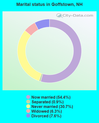
- Never married: 30.7%
- Now married: 54.4%
- Separated: 0.9%
- Widowed: 6.3%
- Divorced: 7.6%
For population 25 years and over in Goffstown:
- High school or higher: 85.0%
- Bachelor's degree or higher: 25.2%
- Graduate or professional degree: 8.5%
- Unemployed: 2.7%
- Mean travel time to work (commute): 26.1 minutes
| Here: | 11.1 |
| New Hampshire average: | 10.9 |


Graphs represent county-level data. Detailed 2008 Election Results
Religion statistics for Goffstown, NH (based on Hillsborough County data)


| Religion | Adherents | Congregations |
|---|---|---|
| Catholic | 124,993 | 40 |
| Evangelical Protestant | 20,588 | 103 |
| Mainline Protestant | 17,794 | 60 |
| Other | 7,365 | 35 |
| Orthodox | 2,990 | 7 |
| Black Protestant | - | 1 |
| None | 226,991 | - |
Food Environment Statistics:
| Here: | 1.82 / 10,000 pop. |
| New Hampshire: | 2.14 / 10,000 pop. |
| Hillsborough County: | 0.12 / 10,000 pop. |
| New Hampshire: | 0.15 / 10,000 pop. |
| Hillsborough County: | 1.65 / 10,000 pop. |
| State: | 1.78 / 10,000 pop. |
| Hillsborough County: | 2.67 / 10,000 pop. |
| New Hampshire: | 4.02 / 10,000 pop. |
| Here: | 8.23 / 10,000 pop. |
| New Hampshire: | 9.70 / 10,000 pop. |
| Hillsborough County: | 6.9% |
| New Hampshire: | 7.6% |
| This county: | 24.5% |
| State: | 24.4% |
| This county: | 15.1% |
| New Hampshire: | 15.9% |
6.73% of this county's 2021 resident taxpayers lived in other counties in 2020 ($92,767 average adjusted gross income)
| Here: | 6.73% |
| New Hampshire average: | 7.66% |
0.01% of residents moved from foreign countries ($183 average AGI)
Hillsborough County: 0.01% New Hampshire average: 0.01%
Top counties from which taxpayers relocated into this county between 2020 and 2021:
| from Middlesex County, MA | |
| from Rockingham County, NH | |
| from Merrimack County, NH |
6.49% of this county's 2020 resident taxpayers moved to other counties in 2021 ($81,100 average adjusted gross income)
| Here: | 6.49% |
| New Hampshire average: | 6.80% |
0.02% of residents moved to foreign countries ($105 average AGI)
Hillsborough County: 0.02% New Hampshire average: 0.01%
Top counties to which taxpayers relocated from this county between 2020 and 2021:
| to Rockingham County, NH | |
| to Merrimack County, NH | |
| to Middlesex County, MA |
| Businesses in Goffstown, NH | ||||
| Name | Count | Name | Count | |
|---|---|---|---|---|
| Ace Hardware | 1 | Pizza Hut | 1 | |
| Advance Auto Parts | 1 | RadioShack | 1 | |
| Circle K | 1 | Shaw's | 1 | |
| Curves | 1 | Subway | 1 | |
| Dunkin Donuts | 3 | T-Mobile | 1 | |
| Fashion Bug | 1 | U-Haul | 2 | |
| FedEx | 2 | UPS | 1 | |
| Ford | 1 | YMCA | 1 | |
| McDonald's | 1 | |||
Strongest AM radio stations in Goffstown:
- WKBR (1250 AM; 5 kW; MANCHESTER, NH; Owner: DEVON BROADCASTING COMPANY, INC.)
- WGIR (610 AM; 5 kW; MANCHESTER, NH; Owner: CAPSTAR TX LIMITED PARTNERSHIP)
- WFEA (1370 AM; 5 kW; MANCHESTER, NH; Owner: SAGA COMMUNICATIONS OF NEW ENGLAND, LLC)
- WRKO (680 AM; 50 kW; BOSTON, MA; Owner: ENTERCOM BOSTON LICENSE, LLC)
- WDER (1320 AM; 10 kW; DERRY, NH; Owner: BLOUNT COMMUNICATIONS, INC. OF NH)
- WEEI (850 AM; 50 kW; BOSTON, MA; Owner: ENTERCOM BOSTON LICENSE, LLC)
- WCRN (830 AM; 50 kW; WORCESTER, MA; Owner: CARTER BROADCASTING CORPORATION)
- WKOX (1200 AM; 50 kW; FRAMINGHAM, MA; Owner: CAPSTAR TX LIMITED PARTNERSHIP)
- WWZN (1510 AM; 50 kW; BOSTON, MA; Owner: ROSE CITY RADIO CORPORATION)
- WBIX (1060 AM; 40 kW; NATICK, MA; Owner: LANGER BROADCASTING CORPORATION)
- WBZ (1030 AM; 50 kW; BOSTON, MA; Owner: INFINITY BROADCASTING OPERATIONS, INC.)
- WNNZ (640 AM; 50 kW; WESTFIELD, MA; Owner: CLEAR CHANNEL BROADCASTING LICENSES, INC.)
- WAMG (890 AM; 25 kW; DEDHAM, MA; Owner: MEGA COMMUNICATIONS OF DEDHAM LICENSEE, LLC)
Strongest FM radio stations in Goffstown:
- WGIR-FM (101.1 FM; MANCHESTER, NH; Owner: CAPSTAR TX LIMITED PARTNERSHIP)
- WQLL (96.5 FM; BEDFORD, NH; Owner: SAGA COMMUNICATIONS OF NEW ENGLAND, LLC)
- WZID (95.7 FM; MANCHESTER, NH; Owner: SAGA COMMUNICATIONS OF NEW ENGLAND, LLC)
- WLMW (90.7 FM; MANCHESTER, NH; Owner: KNOWLEDGE FOR LIFE)
- WFEX (92.1 FM; PETERBOROUGH, NH; Owner: FNX BROADCASTING OF NEW HAMPSHIRE LLC)
- WNNH (99.1 FM; HENNIKER, NH; Owner: TELE-MEDIA COMPANY OF NEW HAMPSHIRE, L.L.C.)
- W250AB (97.9 FM; MANCHESTER, NH; Owner: CITADEL BROADCASTING COMPANY)
- W282AF (104.3 FM; CONCORD, NH; Owner: CONCORD BIBLE FELLOWSHIP)
- WHDQ (106.1 FM; CLAREMONT, NH; Owner: GREAT NORTHERN RADIO, L.L.C.)
- WNHI (93.3 FM; BELMONT, NH; Owner: CONCORD BROADCASTING, L.L.C.)
- WTPL (107.7 FM; HILLSBORO, NH; Owner: CONCORD BROADCASTING, L.L.C.)
- WEVO (89.1 FM; CONCORD, NH; Owner: NEW HAMPSHIRE PUBLIC RADIO)
- WVPR (89.5 FM; WINDSOR, VT; Owner: VERMONT PUBLIC RADIO)
- WSCY (106.9 FM; MOULTONBOROUGH, NH; Owner: NORTHEAST COMMUNICATIONS CORPORATION)
- WJYY (105.5 FM; CONCORD, NH; Owner: CONCORD BROADCASTING, L.L.C.)
- WPKQ (103.7 FM; NORTH CONWAY, NH; Owner: CITADEL BROADCASTING COMPANY)
- WHOB (106.3 FM; NASHUA, NH; Owner: TELE-MEDIA COMPANY OF NEW HAMPSHIRE, L.L.C.)
- WOTX-FM (102.3 FM; CONCORD, NH; Owner: CAPITOL B/CING. INCORPORATION, INC.)
- WLKZ (104.9 FM; WOLFEBORO, NH; Owner: TELE-MEDIA COMPANY OF NEW HAMPSHIRE, L.L.C.)
- WXRV (92.5 FM; HAVERHILL, MA; Owner: BEANPOT BROADCASTING CORP.)
TV broadcast stations around Goffstown:
- WMUR-TV (Channel 9; MANCHESTER, NH; Owner: HEARST-ARGYLE PROPERTIES, INC.)
- WNEU (Channel 60; MERRIMACK, NH; Owner: NBC SUBSIDIARY (NH), INC.)
- WFXZ-CA (Channel 24; BOSTON, MA; Owner: BOSTON BROADCASTING CORP.)
- WENH-TV (Channel 11; DURHAM, NH; Owner: UNIVERSITY OF NEW HAMPSHIRE)
- WMEA-TV (Channel 26; BIDDEFORD, ME; Owner: MAINE PUBLIC BROADCASTING CORP.)
- WNDS (Channel 50; DERRY, NH; Owner: CTV OF DERRY, INC)
- WUTF (Channel 66; MARLBOROUGH, MA; Owner: TELEFUTURA BOSTON LLC)
- WUNI (Channel 27; WORCESTER, MA; Owner: ENTRAVISION HOLDINGS, LLC)
- WHDN-LP (Channel 26; BOSTON, MA; Owner: GUENTER MARKSTEINER)
- W29AT (Channel 29; MANCHESTER, NH; Owner: CENTER BROADCASTING CORP. OF NEW HAMPSHIRE)
- WPXG (Channel 21; CONCORD, NH; Owner: PAXSON BOSTON-68 LICENSE, INC.)

- National Bridge Inventory (NBI) Statistics
- 8Number of bridges
- 46ft / 13.5mTotal length
- $25,136,000Total costs
- 37,177Total average daily traffic
- 1,626Total average daily truck traffic
- 55,018Total future (year 2042) average daily traffic
FCC Registered Antenna Towers: 120 (See the full list of FCC Registered Antenna Towers)
FCC Registered Commercial Land Mobile Towers: 3 (See the full list of FCC Registered Commercial Land Mobile Towers in Goffstown, NH)
FCC Registered Private Land Mobile Towers: 10 (See the full list of FCC Registered Private Land Mobile Towers)
FCC Registered Broadcast Land Mobile Towers: 17 (See the full list of FCC Registered Broadcast Land Mobile Towers)
FCC Registered Microwave Towers: 38 (See the full list of FCC Registered Microwave Towers in this town)
FCC Registered Paging Towers: 25 (See the full list of FCC Registered Paging Towers)
FCC Registered Amateur Radio Licenses: 136 (See the full list of FCC Registered Amateur Radio Licenses in Goffstown)
FAA Registered Aircraft: 11 (See the full list of FAA Registered Aircraft in Goffstown)
2002 - 2018 National Fire Incident Reporting System (NFIRS) incidents
- Fire incident types reported to NFIRS in Goffstown, NH
- 62865.6%Structure Fires
- 24325.4%Outside Fires
- 757.8%Mobile Property/Vehicle Fires
- 111.1%Other
 Based on the data from the years 2002 - 2018 the average number of fires per year is 56. The highest number of fires - 103 took place in 2010, and the least - 17 in 2002. The data has a rising trend.
 When looking into fire subcategories, the most incidents belonged to: Structure Fires (65.6%), and Outside Fires (25.4%).
- 77.7%Fuel oil, kerosene, etc.
- 8.9%Bottled, tank, or LP gas
- 7.8%Utility gas
- 2.9%Wood
- 2.4%Electricity
- 0.2%Coal or coke
- 0.2%Other fuel
- 56.2%Fuel oil, kerosene, etc.
- 16.9%Utility gas
- 13.1%Bottled, tank, or LP gas
- 13.1%Electricity
- 0.6%Wood
Goffstown compared to New Hampshire state average:
- Unemployed percentage significantly below state average.
- Hispanic race population percentage below state average.
- Median age below state average.
- Foreign-born population percentage below state average.
- Length of stay since moving in significantly above state average.
- Number of rooms per house significantly below state average.
- House age significantly below state average.
- Institutionalized population percentage above state average.
- Number of college students above state average.
Goffstown on our top lists:
- #30 on the list of "Top 101 cities with largest percentage of males in industries: jewelry, luggage, and leather goods stores (population 5,000+)"
- #31 on the list of "Top 101 cities with largest percentage of males in industries: music stores (population 5,000+)"
- #40 on the list of "Top 101 cities with largest percentage of females in industries: sporting goods, camera, and hobby and toy stores (population 5,000+)"
- #42 on the list of "Top 101 cities with largest percentage of males in industries: beverage and tobacco products (population 5,000+)"
- #45 on the list of "Top 101 cities with largest percentage of females in occupations: information and record clerks except customer service representatives (population 5,000+)"
- #55 on the list of "Top 101 cities with largest percentage of females in industries: vending machine operators (population 5,000+)"
- #65 on the list of "Top 101 cities with largest percentage of males in industries: water transportation (population 5,000+)"
- #70 on the list of "Top 101 cities with largest percentage of males in occupations: food and beverage serving workers except waiters/waitresses (population 5,000+)"
- #71 on the list of "Top 101 cities with largest percentage of females in industries: electrical equipment, appliances, and components (population 5,000+)"
- #76 on the list of "Top 101 cities with largest percentage of males in industries: paper and paper products merchant wholesalers (population 5,000+)"
- #77 on the list of "Top 101 cities with largest percentage of females in industries: radio, tv, and computer stores (population 5,000+)"
- #92 on the list of "Top 101 cities with largest percentage of males in occupations: air transportation workers (population 5,000+)"
- #98 on the list of "Top 101 cities with largest percentage of females in industries: u. s. postal service (population 5,000+)"
- #84 (03045) on the list of "Top 101 zip codes with the largest percentage of French Canadian first ancestries (pop 5,000+)"
- #6 on the list of "Top 101 counties with the lowest Particulate Matter (PM10) Annual air pollution readings in 2012 (µg/m3)"
- #12 on the list of "Top 101 counties with the lowest Particulate Matter (PM2.5) Annual air pollution readings in 2012 (µg/m3)"
- #15 on the list of "Top 101 counties with the lowest number of infant deaths per 1000 residents 2007-2013 (pop. 50,000+)"
- #24 on the list of "Top 101 counties with the largest decrease in the number of infant deaths per 1000 residents 2000-2006 to 2007-2013 (pop. 50,000+)"
- #44 on the list of "Top 101 counties with the lowest Nitrogen Dioxide air pollution readings in 2012 (ppm)"

|
|
Total of 219 patent applications in 2008-2024.