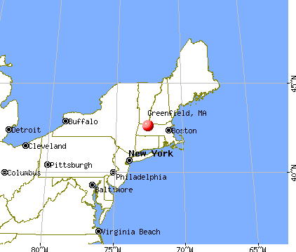
Greenfield, Massachusetts
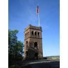
Greenfield: Poet's Seat Tower
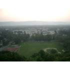
Greenfield: Western view from Poet's Seat Tower, Greenfield, MA
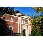
Greenfield: Greenfield Post Office
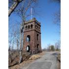
Greenfield: Poet Seat tower
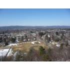
Greenfield: View of Greenfield from Poet's Seat tower
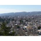
Greenfield: View from Poet's Seat tower
- add
your


Submit your own pictures of this place and show them to the world
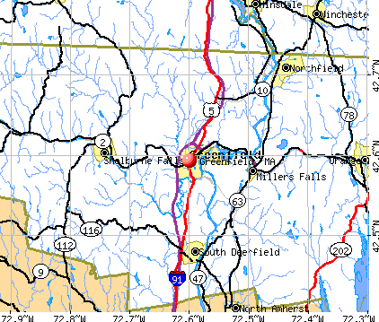
- OSM Map
- General Map
- Google Map
- MSN Map
Population change since 2000: +28.7%
| Males: 8,721 | |
| Females: 8,935 |
| Median resident age: | 44.5 years |
| Massachusetts median age: | 40.3 years |
Zip codes: 01301.
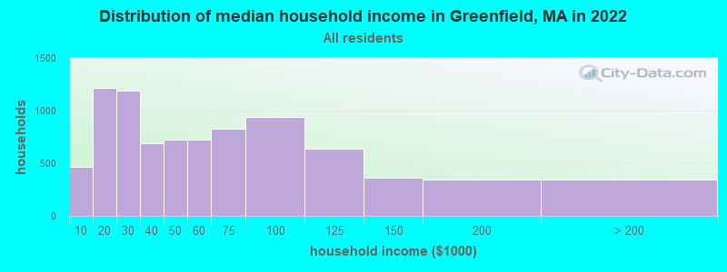
| Greenfield: | $53,091 |
| MA: | $94,488 |
Estimated per capita income in 2022: $31,291 (it was $18,108 in 2000)
Greenfield CDP income, earnings, and wages data
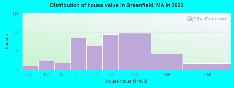
Estimated median house or condo value in 2022: $255,187 (it was $99,100 in 2000)
| Greenfield: | $255,187 |
| MA: | $534,700 |
Mean prices in 2022: all housing units: $257,732; detached houses: $256,304; townhouses or other attached units: $441,715; in 2-unit structures: $289,054; in 3-to-4-unit structures: $434,607; in 5-or-more-unit structures: $157,824; mobile homes: $29,175
Median gross rent in 2022: $910.
(12.7% for White Non-Hispanic residents, 35.9% for Black residents, 30.2% for Hispanic or Latino residents, 38.1% for other race residents, 43.0% for two or more races residents)
Detailed information about poverty and poor residents in Greenfield, MA


- 15,34386.9%White alone
- 1,1926.8%Hispanic
- 4642.6%Black alone
- 3081.7%Asian alone
- 2941.7%Two or more races
- 1050.6%Other race alone
- 80.05%Native Hawaiian and Other
Pacific Islander alone - 60.03%American Indian alone

Races in Greenfield detailed stats: ancestries, foreign born residents, place of birth
According to our research of Massachusetts and other state lists, there were 22 registered sex offenders living in Greenfield, Massachusetts as of May 10, 2024.
The ratio of all residents to sex offenders in Greenfield is 626 to 1.
Type |
2009 |
2010 |
2011 |
2012 |
2013 |
2014 |
2015 |
2016 |
2017 |
2018 |
2019 |
2020 |
2021 |
2022 |
|---|---|---|---|---|---|---|---|---|---|---|---|---|---|---|
| Murders (per 100,000) | 0 (0.0) | 1 (5.7) | 0 (0.0) | 1 (5.7) | 0 (0.0) | 0 (0.0) | 2 (11.5) | 3 (17.2) | 0 (0.0) | 0 (0.0) | 0 (0.0) | 0 (0.0) | 0 (0.0) | 0 (0.0) |
| Rapes (per 100,000) | 10 (56.1) | 10 (57.3) | 12 (68.3) | 8 (45.3) | 13 (73.9) | 20 (114.2) | 13 (74.9) | 27 (154.7) | 23 (131.7) | 21 (120.4) | 11 (63.0) | 19 (110.2) | 18 (104.5) | 21 (122.1) |
| Robberies (per 100,000) | 3 (16.8) | 8 (45.8) | 12 (68.3) | 22 (124.5) | 15 (85.2) | 15 (85.7) | 8 (46.1) | 8 (45.8) | 14 (80.2) | 10 (57.3) | 10 (57.3) | 8 (46.4) | 1 (5.8) | 5 (29.1) |
| Assaults (per 100,000) | 78 (437.2) | 105 (601.5) | 106 (603.6) | 84 (475.5) | 51 (289.8) | 110 (628.2) | 86 (495.6) | 80 (458.3) | 75 (429.5) | 70 (401.3) | 63 (360.7) | 59 (342.2) | 47 (272.9) | 58 (337.2) |
| Burglaries (per 100,000) | 224 (1,256) | 226 (1,295) | 352 (2,004) | 230 (1,302) | 113 (642.1) | 153 (873.8) | 63 (363.0) | 71 (406.7) | 42 (240.5) | 50 (286.6) | 84 (481.0) | 58 (336.4) | 85 (493.6) | 44 (255.8) |
| Thefts (per 100,000) | 284 (1,592) | 295 (1,690) | 310 (1,765) | 330 (1,868) | 219 (1,244) | 411 (2,347) | 343 (1,976) | 280 (1,604) | 280 (1,603) | 261 (1,496) | 248 (1,420) | 209 (1,212) | 231 (1,341) | 236 (1,372) |
| Auto thefts (per 100,000) | 19 (106.5) | 12 (68.7) | 19 (108.2) | 14 (79.2) | 14 (79.6) | 13 (74.2) | 12 (69.1) | 15 (85.9) | 11 (63.0) | 14 (80.3) | 10 (57.3) | 19 (110.2) | 18 (104.5) | 9 (52.3) |
| Arson (per 100,000) | 6 (33.6) | 3 (17.2) | 2 (11.4) | 4 (22.6) | 1 (5.7) | 5 (28.6) | 2 (11.5) | 4 (22.9) | 6 (34.4) | 1 (5.7) | 0 (0.0) | 1 (5.8) | 4 (23.2) | 3 (17.4) |
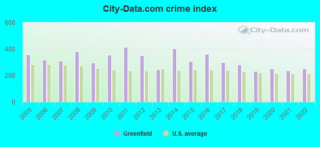
| City-Data.com crime index | 297.4 | 355.1 | 415.4 | 352.2 | 243.7 | 403.7 | 305.9 | 363.0 | 301.3 | 280.1 | 234.8 | 251.4 | 236.5 | 250.8 |
The City-Data.com crime index weighs serious crimes and violent crimes more heavily. Higher means more crime, U.S. average is 246.1. It adjusts for the number of visitors and daily workers commuting into cities.
Crime rate in Greenfield detailed stats: murders, rapes, robberies, assaults, burglaries, thefts, arson
Full-time law enforcement employees in 2020, including police officers: 47 (34 officers - 29 male; 5 female).
| Officers per 1,000 residents here: | 1.97 |
| Massachusetts average: | 2.59 |
 Recent articles from our blog. Our writers, many of them Ph.D. graduates or candidates, create easy-to-read articles on a wide variety of topics.


Latest news from Greenfield, MA collected exclusively by city-data.com from local newspapers, TV, and radio stations
Greenfield, MA City Guides:
Ancestries: English (13.3%), Polish (10.6%), Irish (9.0%), American (7.0%), Italian (5.0%), German (4.5%).
Current Local Time: EST time zone
Elevation: 250 feet
Land area: 5.74 square miles.
Population density: 3,078 people per square mile (average).
950 residents are foreign born (2.2% Europe, 1.6% Latin America, 1.1% Asia).
| This place: | 5.4% |
| Massachusetts: | 17.6% |
Median real estate property taxes paid for housing units with mortgages in 2022: $4,254 (1.7%)
Median real estate property taxes paid for housing units with no mortgage in 2022: $4,590 (1.8%)
Nearest city with pop. 50,000+: Chicopee, MA  (29.2 miles , pop. 54,653).
Nearest city with pop. 200,000+: Boston, MA (79.3 miles , pop. 589,141).
Nearest city with pop. 1,000,000+: Bronx, NY (137.5 miles , pop. 1,332,650).
Nearest cities:
), ), )Latitude: 42.59 N, Longitude: 72.60 W
Daytime population change due to commuting: +2,383 (+13.5%)
Workers who live and work in this place: 4,980 (64.7%)
Area code: 413

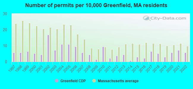
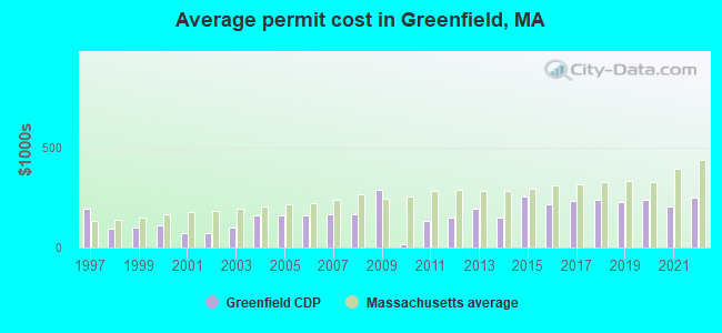
Single-family new house construction building permits:
- 2022: 8 buildings, average cost: $250,800
- 2021: 10 buildings, average cost: $202,700
- 2020: 8 buildings, average cost: $235,600
- 2019: 4 buildings, average cost: $225,000
- 2018: 7 buildings, average cost: $238,600
- 2017: 9 buildings, average cost: $230,500
- 2016: 3 buildings, average cost: $215,400
- 2015: 4 buildings, average cost: $252,700
- 2014: 1 building, cost: $150,900
- 2013: 6 buildings, average cost: $191,000
- 2012: 5 buildings, average cost: $150,600
- 2011: 3 buildings, average cost: $133,500
- 2010: 13 buildings, average cost: $17,000
- 2009: 2 buildings, average cost: $285,000
- 2008: 6 buildings, average cost: $165,400
- 2007: 8 buildings, average cost: $165,400
- 2006: 13 buildings, average cost: $162,100
- 2005: 15 buildings, average cost: $162,100
- 2004: 15 buildings, average cost: $162,100
- 2003: 10 buildings, average cost: $101,500
- 2002: 23 buildings, average cost: $71,600
- 2001: 6 buildings, average cost: $72,600
- 2000: 7 buildings, average cost: $109,900
- 1999: 9 buildings, average cost: $98,400
- 1998: 8 buildings, average cost: $94,500
- 1997: 8 buildings, average cost: $190,700
| Here: | 3.0% |
| Massachusetts: | 3.5% |
- Educational services (12.7%)
- Health care (12.4%)
- Accommodation & food services (7.2%)
- Public administration (3.9%)
- Food & beverage stores (3.9%)
- Miscellaneous manufacturing (3.4%)
- Construction (3.3%)
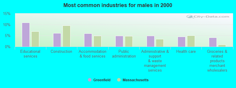
- Educational services (10.9%)
- Construction (6.1%)
- Accommodation & food services (5.9%)
- Public administration (5.0%)
- Administrative & support & waste management services (4.9%)
- Health care (4.5%)
- Groceries & related products merchant wholesalers (4.2%)
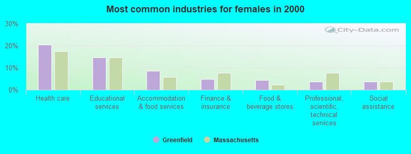
- Health care (20.5%)
- Educational services (14.6%)
- Accommodation & food services (8.5%)
- Finance & insurance (4.9%)
- Food & beverage stores (4.3%)
- Professional, scientific, technical services (3.8%)
- Social assistance (3.7%)
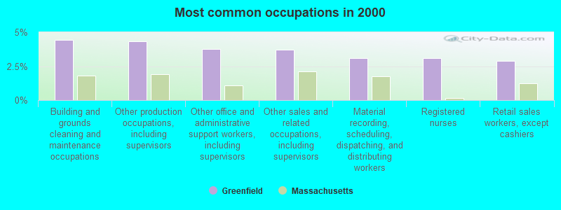
- Building and grounds cleaning and maintenance occupations (4.4%)
- Other production occupations, including supervisors (4.3%)
- Other office and administrative support workers, including supervisors (3.8%)
- Other sales and related occupations, including supervisors (3.7%)
- Material recording, scheduling, dispatching, and distributing workers (3.1%)
- Registered nurses (3.1%)
- Retail sales workers, except cashiers (2.9%)
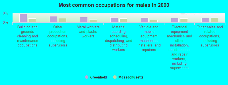
- Building and grounds cleaning and maintenance occupations (7.4%)
- Other production occupations, including supervisors (5.3%)
- Metal workers and plastic workers (4.7%)
- Material recording, scheduling, dispatching, and distributing workers (4.2%)
- Vehicle and mobile equipment mechanics, installers, and repairers (4.1%)
- Electrical equipment mechanics and other installation, maintenance, and repair workers, including supervisors (4.0%)
- Other sales and related occupations, including supervisors (3.9%)
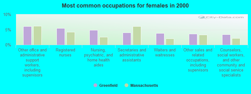
- Other office and administrative support workers, including supervisors (6.1%)
- Registered nurses (5.5%)
- Nursing, psychiatric, and home health aides (4.8%)
- Secretaries and administrative assistants (4.1%)
- Waiters and waitresses (3.8%)
- Other sales and related occupations, including supervisors (3.6%)
- Counselors, social workers, and other community and social service specialists (3.4%)
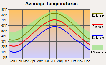
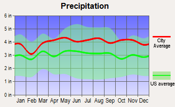
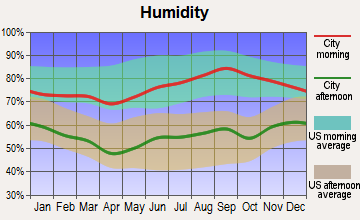
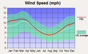
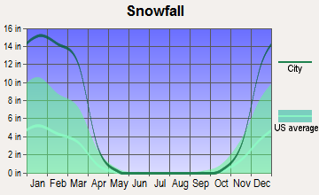
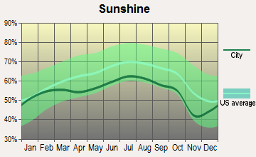
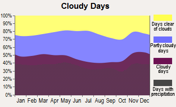
Average climate in Greenfield, Massachusetts
Based on data reported by over 4,000 weather stations
|
|


(lower is better)
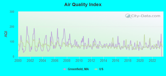
Air Quality Index (AQI) level in 2022 was 69.2. This is about average.
| City: | 69.2 |
| U.S.: | 72.6 |
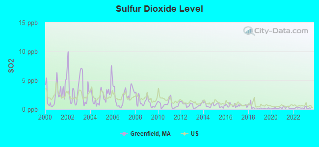
Sulfur Dioxide (SO2) [ppb] level in 2022 was 0.216. This is significantly better than average. Closest monitor was 0.9 miles away from the city center.
| City: | 0.216 |
| U.S.: | 1.515 |
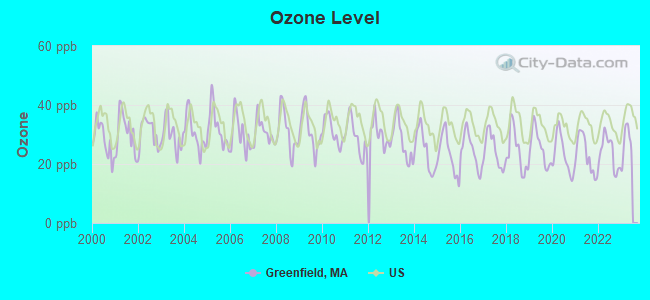
Ozone [ppb] level in 2022 was 23.8. This is better than average. Closest monitor was 0.9 miles away from the city center.
| City: | 23.8 |
| U.S.: | 33.3 |
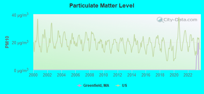
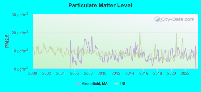
Particulate Matter (PM2.5) [µg/m3] level in 2022 was 7.28. This is about average. Closest monitor was 0.9 miles away from the city center.
| City: | 7.28 |
| U.S.: | 8.11 |
Tornado activity:
Greenfield-area historical tornado activity is above Massachusetts state average. It is 13% smaller than the overall U.S. average.
On 6/9/1953, a category F4 (max. wind speeds 207-260 mph) tornado 23.5 miles away from the Greenfield place center killed 90 people and injured 1228 people and caused between $50,000,000 and $500,000,000 in damages.
On 10/3/1979, a category F4 tornado 37.9 miles away from the place center killed 3 people and injured 500 people and caused between $50,000,000 and $500,000,000 in damages.
Earthquake activity:
Greenfield-area historical earthquake activity is significantly above Massachusetts state average. It is 70% smaller than the overall U.S. average.On 10/7/1983 at 10:18:46, a magnitude 5.3 (5.1 MB, 5.3 LG, 5.1 ML, Class: Moderate, Intensity: VI - VII) earthquake occurred 128.6 miles away from Greenfield center
On 4/20/2002 at 10:50:47, a magnitude 5.3 (5.3 ML, Depth: 3.0 mi) earthquake occurred 143.7 miles away from the city center
On 4/20/2002 at 10:50:47, a magnitude 5.2 (5.2 MB, 4.2 MS, 5.2 MW, 5.0 MW) earthquake occurred 142.5 miles away from Greenfield center
On 1/19/1982 at 00:14:42, a magnitude 4.7 (4.5 MB, 4.7 MD, 4.5 LG, Class: Light, Intensity: IV - V) earthquake occurred 80.6 miles away from the city center
On 10/16/2012 at 23:12:25, a magnitude 4.7 (4.7 ML, Depth: 10.0 mi) earthquake occurred 120.3 miles away from Greenfield center
On 10/2/1994 at 11:27:22, a magnitude 3.7 (3.5 LG, 3.7 LG, Depth: 6.2 mi, Class: Light, Intensity: II - III) earthquake occurred 23.7 miles away from Greenfield center
Magnitude types: regional Lg-wave magnitude (LG), body-wave magnitude (MB), duration magnitude (MD), local magnitude (ML), surface-wave magnitude (MS), moment magnitude (MW)
Natural disasters:
The number of natural disasters in Franklin County (20) is greater than the US average (15).Major Disasters (Presidential) Declared: 9
Emergencies Declared: 10
Causes of natural disasters: Floods: 5, Storms: 5, Hurricanes: 4, Snowstorms: 4, Winter Storms: 3, Blizzards: 2, Snows: 2, Snowfall: 1, Tropical Storm: 1, Wind: 1, Other: 1 (Note: some incidents may be assigned to more than one category).
Hospitals in Greenfield:
- BAYSTATE FRANKLIN MEDICAL CENTER (Voluntary non-profit - Private, provides emergency services, 164 HIGH STREET)
- HOSPICE OF FRANKLIN COUNTY (164 HIGH STREET)
- HOSPICE OF FRANKLIN COUNTY, INC (329 CONWAY STREET)
Nursing Homes in Greenfield:
- BUCKLEY-GREENFIELD HEALTHCARE CENTER (95 LAUREL STREET)
- CHARLENE MANOR EXTENDED CARE FACILITY (130 COLRAIN ROAD)
- FRANKLIN CENTER (329 CONWAY ST)
- POET'S SEAT HEALTH CARE CENTER (359 HIGH STREET)
Dialysis Facilities in Greenfield:
Home Health Centers in Greenfield:
Amtrak stations near Greenfield:
- 16 miles: AMHERST (RAILROAD ST.) . Services: enclosed waiting area, public payphones, free short-term parking, paid long-term parking, call for car rental service, call for taxi service, public transit connection.
- 18 miles: BRATTLEBORO (VERNON RD.) . Services: enclosed waiting area, public restrooms, call for car rental service, call for taxi service.
Operable nuclear power plant near Greenfield:
- 13 miles: Vermont Yankee in Vernon, VT.
College/University in Greenfield:
Colleges/universities with over 2000 students nearest to Greenfield:
- University of Massachusetts-Amherst (about 15 miles; Amherst, MA; Full-time enrollment: 26,583)
- Smith College (about 20 miles; Northampton, MA; FT enrollment: 3,549)
- Mount Holyoke College (about 24 miles; South Hadley, MA; FT enrollment: 2,573)
- Holyoke Community College (about 28 miles; Holyoke, MA; FT enrollment: 4,911)
- Keene State College (about 29 miles; Keene, NH; FT enrollment: 5,098)
- Franklin Pierce University (about 31 miles; Rindge, NH; FT enrollment: 2,139)
- Mount Wachusett Community College (about 32 miles; Gardner, MA; FT enrollment: 3,143)
Public high schools in Greenfield:
- GREENFIELD HIGH (Students: 489, Location: 21 BARR AVENUE, Grades: 8-12)
- FOUR RIVERS CHARTER PUBLIC SCHOOL (Students: 161, Location: 248 COLRAIN ROAD, Grades: 7-12, Charter school)
- MASSACHUSETTS VIRTUAL ACADEMY AT GREENFIELD COMMON (Location: 278 MAIN ST., Grades: KG-12)
Private high school in Greenfield:
Public elementary/middle schools in Greenfield:
- GREENFIELD MIDDLE (Students: 385, Location: 195 FEDERAL STREET, Grades: 4-7)
- NEWTON SCHOOL (Students: 195, Location: 70 SHELBURNE RD, Grades: KG-3)
- GREEN RIVER (Students: 129, Location: 62 MERIDIAN STREET, Grades: 4-7)
- DISCOVERY SCHOOL AT FOUR CORNERS (Location: 21 FERRANTE AVENUE, Grades: KG-3)
- FEDERAL STREET SCHOOL (Location: 125 FEDERAL STREET, Grades: KG-3)
Private elementary/middle schools in Greenfield:
Points of interest:
Notable locations in Greenfield: Baystate Health System Ambulance Service (A), Greenfield Fire Department (B), Franklin County Jail (C), Greenfield Middle School Library (D), Greenfield High School Library (E), Franklin Law Library (F). Display/hide their locations on the map
Churches in Greenfield include: Second Congregational Church (A), Salvation Army (B), Saint Pauls Lutheran Church (C), Saint James Episcopal Church (D), Living Water Assembly of God Church (E), Forgiven Heart Fellowship Church (F), First United Methodist Church (G), First Congregational Church (H), First Church of Christ Scientist (I). Display/hide their locations on the map
Cemeteries: High Street Cemetery (1), Polish Cemetery (2), Calvary Cemetery (3), Green River Cemetery (4). Display/hide their locations on the map
Reservoir: Nash Pond (A). Display/hide its location on the map
Streams, rivers, and creeks: Mill Brook (A), Smead Brook (B), Wheeler Brook (C), Green River (D), Arms Brook (E), Cherry Rum Brook (F), Graves Brook (G). Display/hide their locations on the map
Parks in Greenfield include: Main Street Historic District (1), Temple Woods (2), Rocky Mountain Park (3), Highland Park (4). Display/hide their locations on the map
Tourist attractions: Historical Society of Greenfield (Cultural Attractions- Events- & Facilities; 43 Church Street), Museum of Our Industrial Heritage (Cultural Attractions- Events- & Facilities; 77 Petty Plain Road), Mass Commonwealth - Trial Courts- Franklin County- District Court- Law Libra (Cultural Attractions- Events- & Facilities; 425 Main Street), Franklin County Chamber of Commerce - Visitors Information Center (18 Miner Street).
Hotels: Howard Johnson (125 Mohawk Trail), Candle Light Motor Inn (208 Mohawk Trail), Howard Johnson Inn & Restaurant (125 Mohawk Trl).
Courts: Mass Commonwealth Of Western Division Housing Court (106 Main Street), Franklin County - Courts- Juvenile Court- Main Number (114 Main Street), Mass Commonwealth - District Court- Probate and Family Court Greenf (425 Main Street), Franklin County - Courts- Probate & Family Court (425 Main Street), Mass Commonwealth - Courts- Probate And Family Court Greenfield- Family Service Probation Of (425 Main Street), Franklin County - Superior Court- Courts- Passport (425 Main Street), Franklin County - Courts- District Court- Probation (425 Main Street), Franklin County - Courts- District Court (425 Main Street), Mass Commonwealth - Courts- Superior Court- Greenfield- Probation (425 Main Street).
Birthplace of: Charles Pomeroy Stone - Union Army general, Penn Jillette - Film actor, Rufus Saxton - Army Medal of Honor recipient and Union Army general, Herbert Abrams - Painter and portrait artist, Charles Allen (jurist) - Politician, Dave Wissman - Baseball player, Fred Wallner - Football player, Jake Lacy - Actor, John E. Russell - Politician, Jonathan Healy - Politician.
Drinking water stations with addresses in Greenfield and their reported violations in the past:
GREENFIELD WATER DEPARTMENT (Address: 14 COURT SQUARE , Population served: 17,645, Surface water):Past health violations:Past monitoring violations:
- Treatment Technique (SWTR and GWR) - Between JAN-2011 and DEC-2011. Follow-up actions: St AO (w/o penalty) issued (MAR-15-2012)
- 2 regular monitoring violations
| This place: | 2.1 people |
| Massachusetts: | 2.5 people |
| This place: | 51.0% |
| Whole state: | 65.0% |
| This place: | 7.8% |
| Whole state: | 5.4% |
Likely homosexual households (counted as self-reported same-sex unmarried-partner households)
- Lesbian couples: 0.8% of all households
- Gay men: 0.3% of all households
People in group quarters in Greenfield in 2000:
- 320 people in nursing homes
- 180 people in local jails and other confinement facilities (including police lockups)
- 63 people in homes or halfway houses for drug/alcohol abuse
- 60 people in other noninstitutional group quarters
- 20 people in hospitals or wards for drug/alcohol abuse
- 12 people in other nonhousehold living situations
- 10 people in other group homes
- 8 people in homes for the mentally ill
Banks with branches in Greenfield (2011 data):
- People's United Bank: Greenfield Branch at 45 Federal Street, branch established on 1977/09/28; Greenfield Branch at 280 Mohawk Trail, branch established on 1971/09/01. Info updated 2012/02/16: Bank assets: $27,319.3 mil, Deposits: $20,835.4 mil, headquarters in Bridgeport, CT, positive income, Commercial Lending Specialization, 374 total offices
- Greenfield Co-operative Bank: Greenfield Co-Operative Bank at 63 Federal Street, branch established on 1905/01/01; Federal Street Branch at 277 Federal Street, branch established on 1988/03/07. Info updated 2008/12/09: Bank assets: $308.4 mil, Deposits: $260.0 mil, local headquarters, positive income, Mortgage Lending Specialization, 5 total offices, Holding Company: Greenfield Bancorp Mhc
- RBS Citizens, National Association: Greenfield Stop & Shop Branc at 89 French King Highway, branch established on 2001/12/19. Info updated 2007/09/19: Bank assets: $106,940.6 mil, Deposits: $75,690.2 mil, headquarters in Providence, RI, positive income, 1135 total offices, Holding Company: Uk Financial Investments Limited
- TD Bank, National Association: Greenfield Branch at 324 Main Street, branch established on 1849/05/24. Info updated 2010/10/04: Bank assets: $188,912.6 mil, Deposits: $153,149.8 mil, headquarters in Wilmington, DE, positive income, 1314 total offices, Holding Company: Toronto-Dominion Bank, The
- Bank of America, National Association: Greenfield - Federal Street Branch at 208 Federal Street, branch established on 1968/12/23. Info updated 2009/11/18: Bank assets: $1,451,969.3 mil, Deposits: $1,077,176.8 mil, headquarters in Charlotte, NC, positive income, 5782 total offices, Holding Company: Bank Of America Corporation
- Greenfield Savings Bank: at 400 Main Street, branch established on 1869/03/19. Info updated 2006/10/11: Bank assets: $640.0 mil, Deposits: $458.2 mil, local headquarters, positive income, Mortgage Lending Specialization, 6 total offices, Holding Company: Gsb, Mhc
For population 15 years and over in Greenfield:
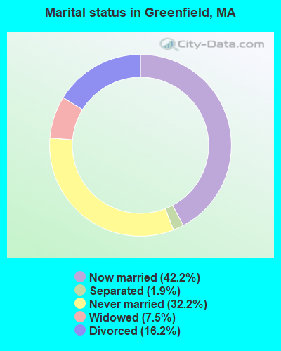
- Never married: 32.2%
- Now married: 42.2%
- Separated: 1.9%
- Widowed: 7.5%
- Divorced: 16.2%
For population 25 years and over in Greenfield:
- High school or higher: 91.4%
- Bachelor's degree or higher: 37.0%
- Graduate or professional degree: 15.4%
- Unemployed: 5.2%
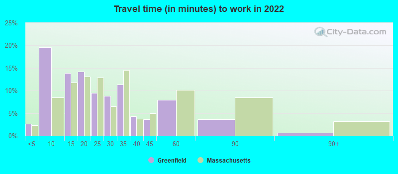
- Mean travel time to work (commute): 15.4 minutes

| Here: | 12.5 |
| Massachusetts average: | 13.0 |


Graphs represent county-level data. Detailed 2008 Election Results
Religion statistics for Greenfield, MA (based on Franklin County data)


| Religion | Adherents | Congregations |
|---|---|---|
| Catholic | 16,509 | 15 |
| Mainline Protestant | 4,617 | 38 |
| Evangelical Protestant | 2,079 | 20 |
| Other | 1,580 | 21 |
| None | 46,587 | - |
Food Environment Statistics:
| Franklin County: | 3.63 / 10,000 pop. |
| State: | 1.98 / 10,000 pop. |
| This county: | 0.14 / 10,000 pop. |
| Massachusetts: | 0.05 / 10,000 pop. |
| Franklin County: | 1.67 / 10,000 pop. |
| Massachusetts: | 2.22 / 10,000 pop. |
| Franklin County: | 3.21 / 10,000 pop. |
| Massachusetts: | 1.77 / 10,000 pop. |
| Franklin County: | 8.10 / 10,000 pop. |
| Massachusetts: | 8.76 / 10,000 pop. |
| Franklin County: | 7.5% |
| Massachusetts: | 8.1% |
| This county: | 22.2% |
| State: | 22.5% |
| This county: | 15.1% |
| Massachusetts: | 16.5% |
| Local government employment and payroll (March 2022) | |||||
| Function | Full-time employees | Monthly full-time payroll | Average yearly full-time wage | Part-time employees | Monthly part-time payroll |
|---|---|---|---|---|---|
| Elementary and Secondary - Instruction | 348 | $1,578,061 | $54,416 | 74 | $55,128 |
| Elementary and Secondary - Other Total | 37 | $143,489 | $46,537 | 45 | $57,511 |
| Police Protection - Officers | 36 | $285,900 | $95,300 | 0 | $0 |
| Firefighters | 27 | $183,834 | $81,704 | 1 | $647 |
| Streets and Highways | 21 | $115,156 | $65,803 | 1 | $828 |
| Other and Unallocable | 17 | $95,245 | $67,232 | 8 | $12,573 |
| Other Government Administration | 13 | $63,718 | $58,817 | 2 | $8,140 |
| Financial Administration | 12 | $68,993 | $68,993 | 4 | $8,919 |
| Parks and Recreation | 12 | $54,932 | $54,932 | 9 | $9,194 |
| Local Libraries | 12 | $48,245 | $48,245 | 2 | $837 |
| Sewerage | 11 | $53,546 | $58,414 | 0 | $0 |
| Police - Other | 10 | $51,429 | $61,715 | 0 | $0 |
| Water Supply | 8 | $37,630 | $56,445 | 0 | $0 |
| Solid Waste Management | 8 | $34,277 | $51,416 | 0 | $0 |
| Welfare | 8 | $38,591 | $57,887 | 1 | $558 |
| Health | 4 | $19,109 | $57,327 | 1 | $3,596 |
| Housing and Community Development (Local) | 3 | $16,474 | $65,896 | 2 | $616 |
| Fire - Other | 1 | $4,805 | $57,660 | 0 | $0 |
| Totals for Government | 588 | $2,893,434 | $59,050 | 150 | $158,546 |
| Businesses in Greenfield, MA | ||||
| Name | Count | Name | Count | |
|---|---|---|---|---|
| AT&T | 1 | Lane Furniture | 1 | |
| Applebee's | 1 | MasterBrand Cabinets | 3 | |
| AutoZone | 1 | Maurices | 1 | |
| Burger King | 1 | McDonald's | 2 | |
| CVS | 1 | New Balance | 1 | |
| Chevrolet | 1 | Nike | 3 | |
| Circle K | 1 | Penske | 1 | |
| Curves | 1 | Quality | 1 | |
| Days Inn | 1 | RadioShack | 1 | |
| Domino's Pizza | 1 | Rite Aid | 1 | |
| Dunkin Donuts | 2 | Staples | 1 | |
| Fashion Bug | 1 | Stop & Shop | 1 | |
| FedEx | 2 | Subway | 2 | |
| Ford | 1 | Taco Bell | 1 | |
| GNC | 1 | Toyota | 1 | |
| H&R Block | 1 | True Value | 1 | |
| Hilton | 1 | U-Haul | 4 | |
| Home Depot | 1 | UPS | 4 | |
| Honda | 1 | Vans | 1 | |
| Hyundai | 1 | Walgreens | 1 | |
| KFC | 1 | Wendy's | 1 | |
| La-Z-Boy | 1 | YMCA | 1 | |
Strongest AM radio stations in Greenfield:
- WIZZ (1520 AM; daytime; 10 kW; GREENFIELD, MA; Owner: P. & M. RADIO, LLC)
- WHMQ (1240 AM; 1 kW; GREENFIELD, MA; Owner: SAGA COMMUNICATIONS OF NEW ENGLAND, LLC)
- WNNZ (640 AM; 50 kW; WESTFIELD, MA; Owner: CLEAR CHANNEL BROADCASTING LICENSES, INC.)
- WCRN (830 AM; 50 kW; WORCESTER, MA; Owner: CARTER BROADCASTING CORPORATION)
- WVNE (760 AM; daytime; 25 kW; LEICESTER, MA; Owner: BLOUNT MASSCOM, INC.)
- WTIC (1080 AM; 50 kW; HARTFORD, CT; Owner: INFINITY RADIO OPERATIONS INC.)
- WRKO (680 AM; 50 kW; BOSTON, MA; Owner: ENTERCOM BOSTON LICENSE, LLC)
- WCAT (700 AM; daytime; 2 kW; ORANGE-ATHOL, MA; Owner: CITADEL BROADCASTING COMPANY)
- WPNI (1430 AM; 5 kW; AMHERST, MA; Owner: WESTERN MASSACHUSETTS RADIO COMPANY)
- WEEI (850 AM; 50 kW; BOSTON, MA; Owner: ENTERCOM BOSTON LICENSE, LLC)
- WGY (810 AM; 50 kW; SCHENECTADY, NY; Owner: CLEAR CHANNEL BROADCASTING LICENSES, INC.)
- WALE (990 AM; 50 kW; GREENVILLE, RI; Owner: NORTH AMERICAN BROADCASTING CO., INC.)
- WHYN (560 AM; 5 kW; SPRINGFIELD, MA; Owner: CLEAR CHANNEL BROADCASTING LICENSES, INC.)
Strongest FM radio stations in Greenfield:
- WHAI (98.3 FM; GREENFIELD, MA; Owner: SAGA COMMUNICATIONS OF NEW ENGLAND, LLC)
- WRSI (93.9 FM; TURNERS FALLS, MA; Owner: GREAT NORTHERN RADIO, LLC)
- WPVQ (95.3 FM; GREENFIELD, MA; Owner: GREAT NORTHERN RADIO, L.L.C.)
- WGAJ (91.7 FM; DEERFIELD, MA; Owner: TRUATEES OF DEERFIELD ACADEMY)
- WAMC-FM (90.3 FM; ALBANY, NY; Owner: WAMC)
- WFCR (88.5 FM; AMHERST, MA; Owner: UNIVERSITY OF MASSACHUSETTS)
- WYRY (104.9 FM; HINSDALE, NH; Owner: TRI-VALLEY BROADCASTING CORPORATION)
- WVAY (100.7 FM; WILMINGTON, VT; Owner: GREAT NORTHERN RADIO, L.L.C.)
- WRSY (101.5 FM; MARLBORO, VT; Owner: GREAT NORTHERN RADIO, L.L.C.)
- WAMH (89.3 FM; AMHERST, MA; Owner: TRUSTEES OF AMHERST COLLEGE)
- WEQX (102.7 FM; MANCHESTER, VT; Owner: NORTHSHIRE COMMUNICATIONS, INC.)
- WHYN-FM (93.1 FM; SPRINGFIELD, MA; Owner: CLEAR CHANNEL BROADCASTING LICENSES, INC.)
- WJAN (95.1 FM; SUNDERLAND, VT; Owner: 6 JOHNSON ROAD LICENSES, INC.)
- WRNX (100.9 FM; AMHERST, MA; Owner: WESTERN MASSACHUSETTS RADIO COMPANY)
- WJDF (97.3 FM; ORANGE, MA; Owner: DEANE BROTHERS BROADCASTING CORP.)
- W246AM (97.1 FM; AMHERST, MA; Owner: GREAT NORTHERN RADIO, LLC)
- WOQL (98.7 FM; WINCHESTER, NH; Owner: SAGA COMMUNICATIONS OF NEW HAMPSHIRE, LLC)
- WLZX (99.3 FM; NORTHAMPTON, MA; Owner: SAGA COMMUNICATIONS OF NEW ENGLAND, LLC)
- WKVT-FM (92.7 FM; BRATTLEBORO, VT; Owner: SAGA COMMUNICATIONS OF NEW ENGLAND, LLC)
- WHDQ (106.1 FM; CLAREMONT, NH; Owner: GREAT NORTHERN RADIO, L.L.C.)
TV broadcast stations around Greenfield:
- WYDN (Channel 48; WORCESTER, MA; Owner: EDUCATIONAL PUBLIC TV CORPORATION)
- WUNI (Channel 27; WORCESTER, MA; Owner: ENTRAVISION HOLDINGS, LLC)
- W35BK (Channel 35; PLAINFIELD, MA; Owner: LYDIA SYLVANE STOCKWELL)
Medal of Honor Recipients
Medal of Honor Recipient born in Greenfield: Rufus Saxton.
- National Bridge Inventory (NBI) Statistics
- 19Number of bridges
- 276ft / 84.5mTotal length
- $79,090,000Total costs
- 229,540Total average daily traffic
- 20,080Total average daily truck traffic
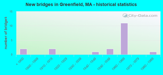
- New bridges - historical statistics
- 2Before 1900
- 21910-1919
- 11940-1949
- 21950-1959
- 111960-1969
- 11980-1989
FCC Registered Cell Phone Towers:
1- 1.5mi @ 235 Deg. True From The Intersection Of I-91 & Sr 2, 3.0mi Sw Of (Lat: 42.570917 Lon: -72.644528), Call Sign: KNKN860
Assigned Frequencies: 869.040 MHz, 890.010 MHz, 824.040 MHz, 845.010 MHzGrant Date: 08/31/2021, Expiration Date: 10/01/2031, Certifier: John T Scott IiiRegistrant: Verizon Wireless, 5055 North Point Pkwy, Np2ne Network Engineering, Alpharetta, GA 30022, Phone: (770) 797-1070, Fax: (770) 797-1036, Email:
FCC Registered Antenna Towers:
3- Sean O'Malley, 4.8 Mi Northeast (Lat: 42.651667 Lon: -72.561389), Type: 60.3, Overall height: 57.9 m, Registrant: American Towers, Inc., Bosto-n, Phone: (617) 585-7600
- Sean O'Malley, 4.8 Mi Northeast (Lat: 42.651667 Lon: -72.561389), Type: 60.3, Overall height: 57.9 m, Registrant: American Towers, Inc., Bosto-n, Phone: (617) 585-7600
- 4.8 Mi Northeast (Lat: 42.651667 Lon: -72.561389), Type: 60.3, Overall height: 57.9 m, Registrant: Atc Tower Corp, Www.Americantower.Com, , Houst-on, Phone: (713) 693-0000
FCC Registered Broadcast Land Mobile Towers:
11 (See the full list of FCC Registered Broadcast Land Mobile Towers in Greenfield, MA)FCC Registered Microwave Towers:
14 (See the full list of FCC Registered Microwave Towers in this town)FCC Registered Paging Towers:
1 (See the full list of FCC Registered Paging Towers)FCC Registered Amateur Radio Licenses:
110 (See the full list of FCC Registered Amateur Radio Licenses in Greenfield)FAA Registered Aircraft:
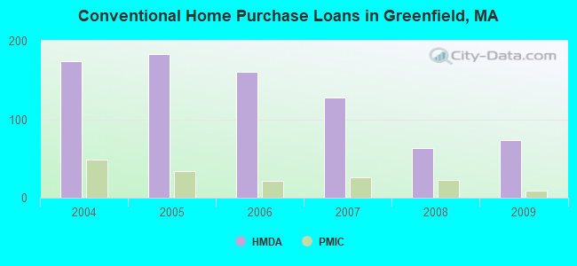
11 (See the full list of FAA Registered Aircraft in Greenfield)| Home Mortgage Disclosure Act Aggregated Statistics For Year 2009 (Based on 3 full and 1 partial tracts) | ||||||||||||
| A) FHA, FSA/RHS & VA Home Purchase Loans | B) Conventional Home Purchase Loans | C) Refinancings | D) Home Improvement Loans | E) Loans on Dwellings For 5+ Families | F) Non-occupant Loans on < 5 Family Dwellings (A B C & D) | |||||||
|---|---|---|---|---|---|---|---|---|---|---|---|---|
| Number | Average Value | Number | Average Value | Number | Average Value | Number | Average Value | Number | Average Value | Number | Average Value | |
| LOANS ORIGINATED | 31 | $149,208 | 74 | $121,299 | 157 | $132,625 | 38 | $69,569 | 3 | $345,333 | 14 | $161,241 |
| APPLICATIONS APPROVED, NOT ACCEPTED | 0 | $0 | 4 | $139,485 | 8 | $113,841 | 4 | $34,000 | 0 | $0 | 3 | $135,667 |
| APPLICATIONS DENIED | 2 | $174,210 | 9 | $69,912 | 42 | $143,119 | 10 | $110,529 | 1 | $341,000 | 1 | $155,920 |
| APPLICATIONS WITHDRAWN | 6 | $133,958 | 2 | $168,425 | 27 | $119,573 | 4 | $98,378 | 0 | $0 | 1 | $92,000 |
| FILES CLOSED FOR INCOMPLETENESS | 0 | $0 | 1 | $98,000 | 13 | $124,470 | 1 | $224,740 | 0 | $0 | 0 | $0 |
Detailed HMDA statistics for the following Tracts: 0411.00 , 0412.00, 0413.00, 0414.00
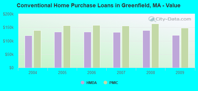
| Private Mortgage Insurance Companies Aggregated Statistics For Year 2009 (Based on 3 full and 1 partial tracts) | ||||||
| A) Conventional Home Purchase Loans | B) Refinancings | C) Non-occupant Loans on < 5 Family Dwellings (A & B) | ||||
|---|---|---|---|---|---|---|
| Number | Average Value | Number | Average Value | Number | Average Value | |
| LOANS ORIGINATED | 9 | $147,871 | 3 | $193,860 | 0 | $0 |
| APPLICATIONS APPROVED, NOT ACCEPTED | 3 | $255,523 | 1 | $209,000 | 1 | $272,000 |
| APPLICATIONS DENIED | 1 | $141,030 | 3 | $245,667 | 2 | $271,000 |
| APPLICATIONS WITHDRAWN | 1 | $90,000 | 1 | $158,000 | 0 | $0 |
| FILES CLOSED FOR INCOMPLETENESS | 0 | $0 | 0 | $0 | 0 | $0 |
Detailed PMIC statistics for the following Tracts: 0411.00 , 0412.00, 0413.00, 0414.00
2002 - 2018 National Fire Incident Reporting System (NFIRS) incidents
- Fire incident types reported to NFIRS in Greenfield, MA
- 1,03756.0%Structure Fires
- 54629.5%Outside Fires
- 1689.1%Mobile Property/Vehicle Fires
- 1015.5%Other
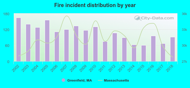 Based on the data from the years 2002 - 2018 the average number of fires per year is 109. The highest number of fire incidents - 165 took place in 2002, and the least - 61 in 2015. The data has a decreasing trend.
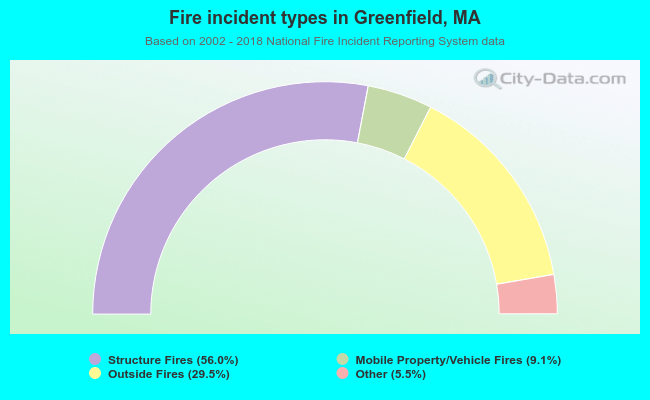 When looking into fire subcategories, the most incidents belonged to: Structure Fires (56.0%), and Outside Fires (29.5%).
Fire-safe hotels and motels in Greenfield, Massachusetts:
- Hampton Inn & Suites, 184 Shelburne Rd, Greenfield, Massachusetts 01301 , Phone: (413) 773-0057, Fax: (413) 223-1300
- Days Inn, 21 Colrain Rd, Greenfield, Massachusetts 01301 , Phone: (413) 774-5578, Fax: (413) 774-4383
| Most common first names in Greenfield, MA among deceased individuals | ||
| Name | Count | Lived (average) |
|---|---|---|
| Mary | 239 | 80.6 years |
| John | 204 | 74.1 years |
| William | 154 | 75.5 years |
| Helen | 134 | 82.1 years |
| Joseph | 134 | 76.4 years |
| George | 129 | 77.1 years |
| James | 107 | 71.5 years |
| Charles | 106 | 75.1 years |
| Robert | 101 | 70.6 years |
| Edward | 100 | 73.5 years |
| Most common last names in Greenfield, MA among deceased individuals | ||
| Last name | Count | Lived (average) |
|---|---|---|
| Smith | 66 | 78.6 years |
| Johnson | 52 | 84.4 years |
| Brown | 34 | 79.5 years |
| Williams | 29 | 74.6 years |
| Martin | 27 | 78.4 years |
| Sullivan | 26 | 76.1 years |
| Mccarthy | 24 | 76.2 years |
| Graves | 23 | 75.0 years |
| Murphy | 22 | 74.7 years |
| Clark | 22 | 76.0 years |
- 45.2%Fuel oil, kerosene, etc.
- 35.1%Utility gas
- 8.0%Electricity
- 5.2%Bottled, tank, or LP gas
- 4.9%Wood
- 1.4%Other fuel
- 0.2%Solar energy
- 43.0%Utility gas
- 29.1%Electricity
- 20.6%Fuel oil, kerosene, etc.
- 3.7%Bottled, tank, or LP gas
- 1.6%No fuel used
- 0.8%Wood
- 0.8%Other fuel
- 0.3%Solar energy
Greenfield compared to Massachusetts state average:
- Median household income below state average.
- Median house value below state average.
- Unemployed percentage below state average.
- Black race population percentage below state average.
- Foreign-born population percentage significantly below state average.
- Renting percentage significantly below state average.
- Length of stay since moving in above state average.
- Institutionalized population percentage significantly above state average.
Greenfield on our top lists:
- #13 on the list of "Top 101 cities with largest percentage of males in industries: groceries and related products merchant wholesalers (population 5,000+)"
- #28 on the list of "Top 101 cities with largest percentage of females in occupations: other transportation workers (population 5,000+)"
- #35 on the list of "Top 101 cities with largest percentage of males in occupations: counselors, social workers, and other community and social service specialists (population 5,000+)"
- #36 on the list of "Top 101 cities with largest percentage of females in industries: groceries and related products merchant wholesalers (population 5,000+)"
- #37 on the list of "Top 101 cities with largest percentage of males in industries: plastics and rubber products (population 5,000+)"
- #46 on the list of "Top 101 cities with largest percentage of females in industries: machinery (population 5,000+)"
- #47 on the list of "Top 101 cities with largest percentage of males in industries: social assistance (population 5,000+)"
- #60 on the list of "Top 101 cities with largest percentage of females in industries: publishing, and motion picture and sound recording industries (population 5,000+)"
- #66 on the list of "Top 101 cities with the most people taking a taxi to work (population 5,000+)"
- #67 on the list of "Top 101 cities with largest percentage of males in industries: miscellaneous manufacturing (population 5,000+)"
- #70 on the list of "Top 101 cities with largest percentage of females in occupations: communications equipment operators (population 5,000+)"
- #72 on the list of "Top 101 cities with largest percentage of females in occupations: postsecondary teachers (population 5,000+)"
- #74 on the list of "Top 101 cities with largest percentage of females in occupations: counselors, social workers, and other community and social service specialists (population 5,000+)"
- #74 on the list of "Top 101 cities with largest percentage of females in industries: plastics and rubber products (population 5,000+)"
- #77 on the list of "Top 101 cities with largest percentage of females in industries: miscellaneous manufacturing (population 5,000+)"
- #78 on the list of "Top 101 cities with largest percentage of males in industries: motor vehicle and parts dealers (population 5,000+)"
- #80 on the list of "Top 101 cities with largest percentage of males in occupations: other food preparation and serving workers including supervisors (population 5,000+)"
- #89 on the list of "Top 101 cities with largest percentage of males in industries: publishing, and motion picture and sound recording industries (population 5,000+)"
- #91 on the list of "Top 101 cities with the largest percentage of people in hospitals or wards for drug/alcohol abuse (population 1,000+)"
- #95 on the list of "Top 101 cities with largest percentage of females in industries: vending machine operators (population 5,000+)"
- #21 on the list of "Top 101 counties with the highest percentage of residents that drank alcohol in the past 30 days"
- #65 on the list of "Top 101 counties with the lowest average weight of females"
- #84 on the list of "Top 101 counties with the lowest surface withdrawal of fresh water for public supply (pop. 50,000+)"
- #88 on the list of "Top 101 counties with the best general health status score of residents (1-5), 3 years of data"
- #92 on the list of "Top 101 counties with the highest percentage of residents that smoked 100+ cigarettes in their lives"

|
|
Total of 32 patent applications in 2008-2024.