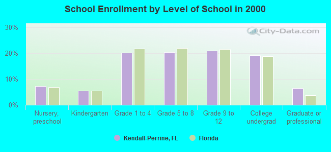
Kendall-Perrine, Florida
Submit your own pictures of this place and show them to the world
- OSM Map
- Google Map
- MSN Map
| Males: 80,273 | |
| Females: 88,734 |
| Median resident age: | 37.0 years |
| Florida median age: | 38.7 years |
Zip code: 33156
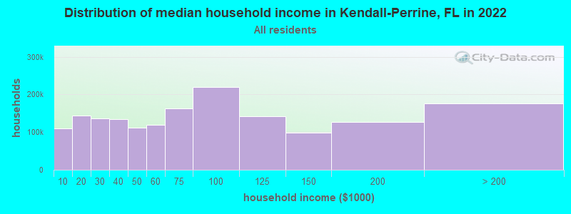
| Kendall-Perrine: | $115,065 |
| FL: | $69,303 |
Estimated per capita income in 2022: $70,031 (it was $34,033 in 2000)
Kendall-Perrine CCD income, earnings, and wages data
Estimated median house or condo value in 2022: $747,224 (it was $186,600 in 2000)
| Kendall-Perrine: | $747,224 |
| FL: | $354,100 |
Mean prices in 2022: all housing units: $606,087; detached houses: $666,163; townhouses or other attached units: $435,342; in 2-unit structures: $480,048; in 3-to-4-unit structures: $325,696; in 5-or-more-unit structures: $554,909; mobile homes: $128,887; occupied boats, rvs, vans, etc.: $162,124
Kendall-Perrine, FL residents, houses, and apartments details
Detailed information about poverty and poor residents in Kendall-Perrine, FL


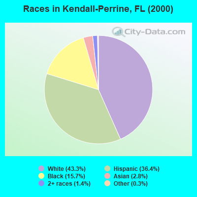
- 67,41343.3%White alone
- 56,60836.4%Hispanic
- 24,43015.7%Black alone
- 4,3652.8%Asian alone
- 2,1601.4%Two or more races
- 4490.3%Other race alone
- 1280.08%American Indian alone
- 360.02%Native Hawaiian and Other
Pacific Islander alone
Races in Kendall-Perrine detailed stats: ancestries, foreign born residents, place of birth
 Recent articles from our blog. Our writers, many of them Ph.D. graduates or candidates, create easy-to-read articles on a wide variety of topics.

Current Local Time: EST time zone
Land area: 45.0 square miles.
Population density: 3,752 people per square mile (average).
| Kendall-Perrine CCD: | 1.7% ($3,095) |
| Florida: | 1.4% ($1,262) |
Nearest city with pop. 200,000+: Kendale Lakes-Lindgren Acres, FL (6.1 miles  , pop. 314,677).
Nearest city with pop. 1,000,000+: Houston, TX (963.6 miles , pop. 1,953,631).
Nearest cities:
), ), ), ), )Latitude: 25.65 N, Longitude: 80.33 W
| Here: | 1.6% |
| Florida: | 2.9% |
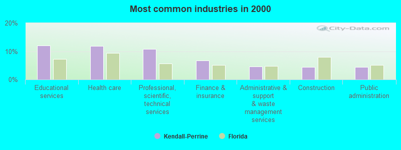
- Educational services (12.1%)
- Health care (11.8%)
- Professional, scientific, technical services (10.7%)
- Finance & insurance (6.7%)
- Administrative & support & waste management services (4.5%)
- Construction (4.5%)
- Public administration (4.5%)

- Professional, scientific, technical services (12.0%)
- Health care (8.0%)
- Construction (7.1%)
- Finance & insurance (6.7%)
- Educational services (6.5%)
- Public administration (5.1%)
- Administrative & support & waste management services (4.9%)
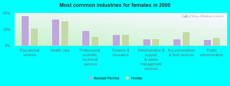
- Educational services (18.5%)
- Health care (16.2%)
- Professional, scientific, technical services (9.2%)
- Finance & insurance (6.8%)
- Administrative & support & waste management services (4.2%)
- Accommodation & food services (4.1%)
- Public administration (3.8%)
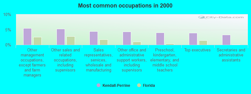
- Other management occupations, except farmers and farm managers (5.5%)
- Other sales and related occupations, including supervisors (5.2%)
- Sales representatives, services, wholesale and manufacturing (4.4%)
- Other office and administrative support workers, including supervisors (4.3%)
- Preschool, kindergarten, elementary, and middle school teachers (4.0%)
- Top executives (3.9%)
- Secretaries and administrative assistants (3.3%)
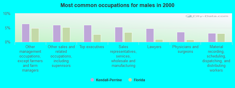
- Other management occupations, except farmers and farm managers (6.4%)
- Other sales and related occupations, including supervisors (6.0%)
- Top executives (6.0%)
- Sales representatives, services, wholesale and manufacturing (5.3%)
- Lawyers (4.8%)
- Physicians and surgeons (3.5%)
- Material recording, scheduling, dispatching, and distributing workers (3.1%)
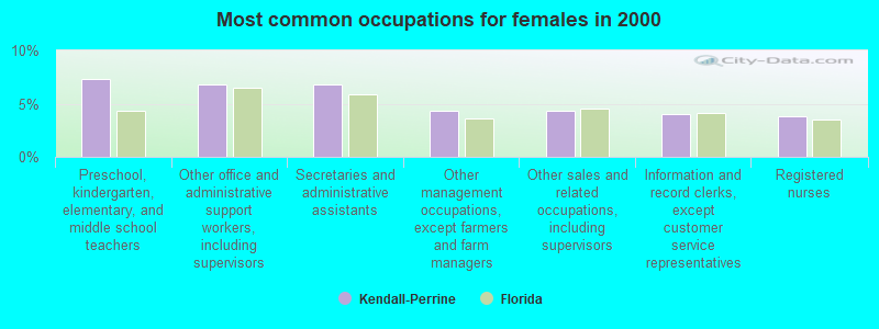
- Preschool, kindergarten, elementary, and middle school teachers (7.4%)
- Other office and administrative support workers, including supervisors (6.8%)
- Secretaries and administrative assistants (6.8%)
- Other management occupations, except farmers and farm managers (4.4%)
- Other sales and related occupations, including supervisors (4.3%)
- Information and record clerks, except customer service representatives (4.1%)
- Registered nurses (3.8%)
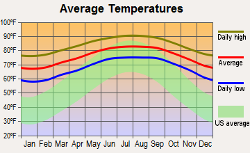
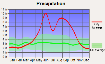
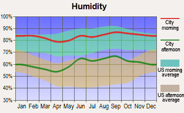
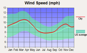
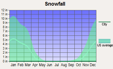
Average climate in Kendall-Perrine, Florida
Based on data reported by over 4,000 weather stations


(lower is better)
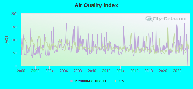
Air Quality Index (AQI) level in 2022 was 79.1. This is about average.
| City: | 79.1 |
| U.S.: | 72.6 |
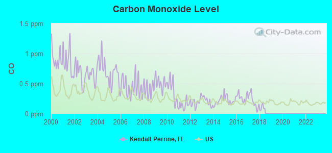
Carbon Monoxide (CO) [ppm] level in 2017 was 0.208. This is better than average. Closest monitor was 1.7 miles away from the city center.
| City: | 0.208 |
| U.S.: | 0.251 |
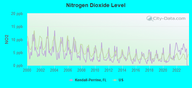
Nitrogen Dioxide (NO2) [ppb] level in 2022 was 6.13. This is about average. Closest monitor was 1.7 miles away from the city center.
| City: | 6.13 |
| U.S.: | 5.11 |
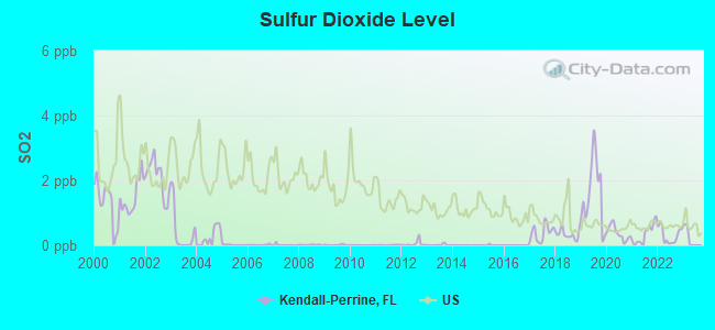
Sulfur Dioxide (SO2) [ppb] level in 2022 was 0.303. This is significantly better than average. Closest monitor was 1.7 miles away from the city center.
| City: | 0.303 |
| U.S.: | 1.515 |
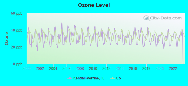
Ozone [ppb] level in 2022 was 30.5. This is about average. Closest monitor was 12.0 miles away from the city center.
| City: | 30.5 |
| U.S.: | 33.3 |
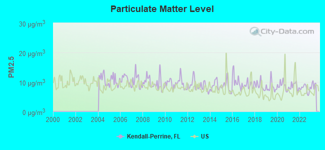
Particulate Matter (PM2.5) [µg/m3] level in 2022 was 7.74. This is about average. Closest monitor was 12.2 miles away from the city center.
| City: | 7.74 |
| U.S.: | 8.11 |
Tornado activity:
Kendall-Perrine-area historical tornado activity is below Florida state average. It is 43% smaller than the overall U.S. average.
On 6/17/1959, a category F3 (max. wind speeds 158-206 mph) tornado 6.3 miles away from the Kendall-Perrine place center injured 77 people and caused between $500,000 and $5,000,000 in damages.
On 4/10/1956, a category F3 tornado 24.9 miles away from the place center injured 20 people and caused between $500,000 and $5,000,000 in damages.
Earthquake activity:
Kendall-Perrine-area historical earthquake activity is significantly below Florida state average. It is 99% smaller than the overall U.S. average.On 9/10/2006 at 14:56:08, a magnitude 5.9 (5.9 MB, 5.5 MS, 5.8 MW, Class: Moderate, Intensity: VI - VII) earthquake occurred 393.8 miles away from Kendall-Perrine center
On 2/22/1992 at 04:21:34, a magnitude 3.2 (3.2 MB, Depth: 6.2 mi, Class: Light, Intensity: II - III) earthquake occurred 102.2 miles away from Kendall-Perrine center
On 6/23/2016 at 17:20:29, a magnitude 3.8 (3.8 ML) earthquake occurred 305.2 miles away from Kendall-Perrine center
On 7/16/2016 at 20:00:10, a magnitude 3.7 (3.7 MB) earthquake occurred 289.7 miles away from Kendall-Perrine center
On 9/21/2016 at 16:30:52, a magnitude 3.8 (3.8 ML) earthquake occurred 310.0 miles away from Kendall-Perrine center
On 9/4/2016 at 18:29:29, a magnitude 3.8 (3.8 ML) earthquake occurred 311.1 miles away from Kendall-Perrine center
Magnitude types: body-wave magnitude (MB), local magnitude (ML), surface-wave magnitude (MS), moment magnitude (MW)
Natural disasters:
The number of natural disasters in Miami-Dade County (10) is smaller than the US average (15).Major Disasters (Presidential) Declared: 5
Emergencies Declared: 3
Causes of natural disasters: Hurricanes: 7, Tropical Storms: 2, Tornado: 1, Other: 1 (Note: some incidents may be assigned to more than one category).
Hospitals and medical centers near Kendall-Perrine:
- BMA - SOUTH MIAMI (Dialysis Facility, about 2 miles away; MIAMI, FL)
- CINTRA HEALTH CARE, INC (Home Health Center, about 3 miles away; MIAMI, FL)
- MDC HOME HEALTH CARE CORP (Home Health Center, about 3 miles away; PALMETTO BAY, FL)
- CORAL REEF NURSING AND REHABILITATION CENTER (Nursing Home, about 3 miles away; MIAMI, FL)
- DADELAND DIALYSIS (Dialysis Facility, about 3 miles away; MIAMI, FL)
- BAPTIST HOME CARE (Home Health Center, about 3 miles away; MIAMI, FL)
- BAPTIST HOSPITAL OF MIAMI INC Acute Care Hospitals (about 3 miles away; MIAMI, FL)
Amtrak stations near Kendall-Perrine:
- 10 miles: MIAMI INT'L AIRPORT (MIAMI, TRANSIT BUS LOADING AREA) - Bus Station
- 15 miles: MIAMI (8303 N.W. 37TH AVE.) . Services: ticket office, fully wheelchair accessible, enclosed waiting area, public restrooms, public payphones, vending machines, free short-term parking, call for car rental service, taxi stand, public transit connection.
- 16 miles: HOMESTEAD (5 N.E. 3RD RD.) - Bus Station . Services: enclosed waiting area, public restrooms, public payphones, vending machines.
Operable nuclear power plants near Kendall-Perrine:
- 17 miles: Turkey Point 3 and 4 in Florida City, FL.
Colleges/universities with over 2000 students nearest to Kendall-Perrine:
- University of Miami (about 6 miles; Coral Gables, FL; Full-time enrollment: 13,674)
- Florida Career College-Miami (about 8 miles; Miami, FL; FT enrollment: 10,133)
- Florida International University (about 8 miles; Miami, FL; FT enrollment: 41,234)
- Miami Dade College (about 13 miles; Miami, FL; FT enrollment: 53,787)
- AI Miami International University of Art and Design (about 14 miles; Miami, FL; FT enrollment: 3,578)
- Florida National University-Main Campus (about 15 miles; Hialeah, FL; FT enrollment: 4,106)
- Barry University (about 18 miles; Miami, FL; FT enrollment: 7,181)
Points of interest:
Notable locations in Kendall-Perrine: Dadeland Square (A), Deerwood Town Center (B), Miller Square (C), Camp Choee Howletee (D), Cocoplum Plaza (E), Champions Club at Julington Creek (F), Kings Bay Country Club (G), Florida Power and Light Cutler Steam Plant (H), Isla Marina (I), Perrine Plaza (J), Keys Railroad Station (K), Coral Way Shopping Plaza (L), Bird-Galloway Center (M), Palmetto Golf Course (N), Briar Bay Golf Course (O), Saint James Golf Club (P), Matheson Hammock Marina (Q), Dadeland Plaza (R), Dadeland South Station (S), Colonial Palms Plaza (T). Display/hide their locations on the map
Shopping Centers: Devonnaire Shopping Center (1), Olympia Heights Shopping Center (2), South Dade Shopping Center (3), Kendall Mall (4), Dadeland Mall (5), Colonial Palms Shopping Center (6), Badeland Mall (7), Dadeland Mall (8), Kendall Market Place Shopping Center (9). Display/hide their locations on the map
Churches in Kendall-Perrine include: Saint Thomas Church (A), Sunset Chapel (B), Saint Catherine of Siena Church (C), Temple Israel (D), Riverside Church (E), Bet Breira Synagogue (F), Wayside Church (G), Grace Church (H), Oak Grove Church (I). Display/hide their locations on the map
Cemeteries: Dade South Memorial Park (1), Woodlawn Park Cemetery South (2), Pinelawn Memorial (3), Charlotte Jane Memorial Park (4), Pine Lawn Memorial Cemetery (5). Display/hide their locations on the map
Lakes: Lago Maggiore (A), Lago Minore (B), Lago Monaco (C), Palmetto Lake (D), Lake Oakland (E), Lake Galloway (F), Snapper Creek Lake (G), Hammock Lake (H). Display/hide their locations on the map
Parks in Kendall-Perrine include: Fairchild Tropical Garden (1), Richmond Park (2), Sabal Chase Park (3), I T T - Snapper Creek Park (4), Chapman Field Park (5), Banyan Drive Park (6), Cartagena Plaza (7), Ingraham Terrace (8), Parrot Jungle (9). Display/hide their locations on the map
| This place: | 2.9 people |
| Florida: | 2.5 people |
| This place: | 61.2% |
| Whole state: | 66.9% |
| This place: | 4.0% |
| Whole state: | 5.8% |
Likely homosexual households (counted as self-reported same-sex unmarried-partner households)
- Lesbian couples: 0.3% of all households
- Gay men: 0.3% of all households
| This place: | 9.0% |
| Whole state: | 12.5% |
| This place: | 4.3% |
| Whole state: | 5.7% |
People in group quarters in Kendall-Perrine in 2000:
- 377 people in nursing homes
- 136 people in homes for the mentally retarded
- 79 people in other noninstitutional group quarters
- 61 people in mental (psychiatric) hospitals or wards
- 52 people in other nonhousehold living situations
- 35 people in homes for abused, dependent, and neglected children
- 25 people in religious group quarters
- 22 people in other group homes
For population 15 years and over in Kendall-Perrine:
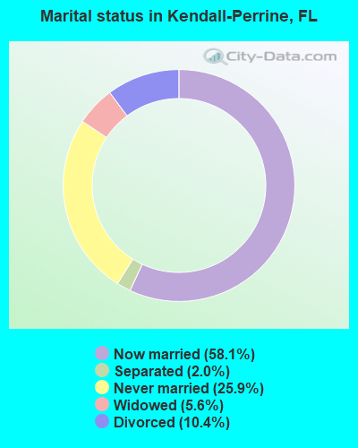
- Never married: 25.9%
- Now married: 58.1%
- Separated: 2.0%
- Widowed: 5.6%
- Divorced: 10.4%
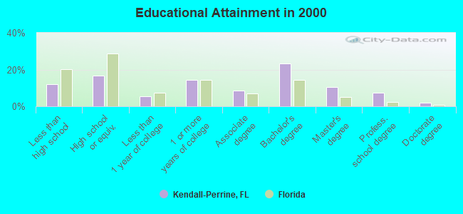
For population 25 years and over in Kendall-Perrine:
- High school or higher: 88.0%
- Bachelor's degree or higher: 42.9%
- Graduate or professional degree: 19.8%
- Unemployed: 4.8%
- Mean travel time to work (commute): 29.8 minutes
| Here: | 12.5 |
| Florida average: | 12.6 |
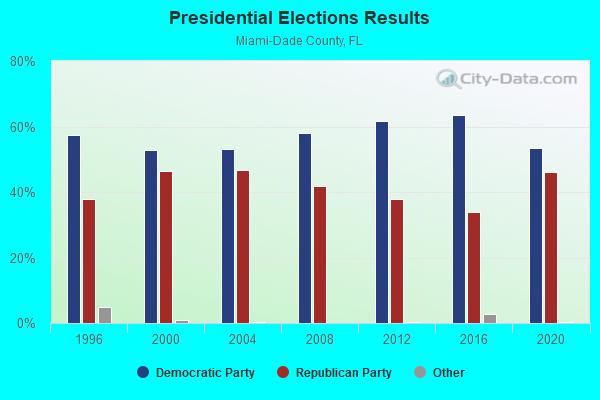
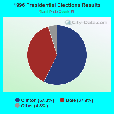
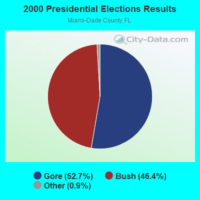
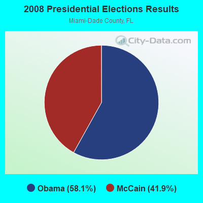
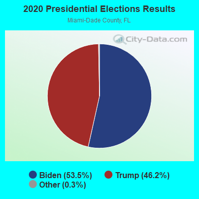
Graphs represent county-level data. Detailed 2008 Election Results
Religion statistics for Kendall-Perrine, FL (based on Miami-Dade County data)
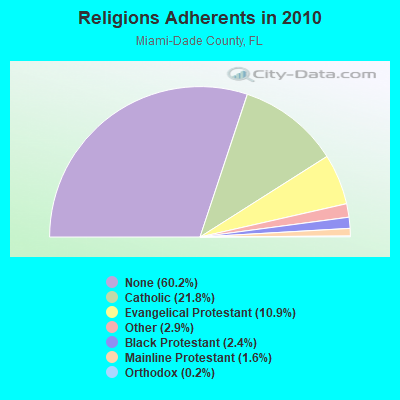
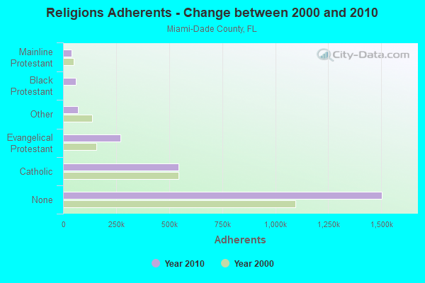
| Religion | Adherents | Congregations |
|---|---|---|
| Catholic | 544,449 | 65 |
| Evangelical Protestant | 271,814 | 922 |
| Other | 71,458 | 200 |
| Black Protestant | 60,074 | 94 |
| Mainline Protestant | 40,287 | 146 |
| Orthodox | 4,440 | 10 |
| None | 1,503,913 | - |
Food Environment Statistics:
| This county: | 2.51 / 10,000 pop. |
| Florida: | 2.04 / 10,000 pop. |
| Here: | 0.06 / 10,000 pop. |
| Florida: | 0.11 / 10,000 pop. |
| Miami-Dade County: | 1.20 / 10,000 pop. |
| State: | 1.28 / 10,000 pop. |
| Miami-Dade County: | 1.98 / 10,000 pop. |
| Florida: | 3.04 / 10,000 pop. |
| This county: | 6.76 / 10,000 pop. |
| Florida: | 7.45 / 10,000 pop. |
| This county: | 7.9% |
| State: | 9.2% |
| This county: | 20.5% |
| State: | 23.7% |
| Here: | 15.8% |
| Florida: | 14.0% |
4.04% of this county's 2021 resident taxpayers lived in other counties in 2020 ($229,296 average adjusted gross income)
| Here: | 4.04% |
| Florida average: | 8.80% |
0.03% of residents moved from foreign countries ($357 average AGI)
Miami-Dade County: 0.03% Florida average: 0.05%
Top counties from which taxpayers relocated into this county between 2020 and 2021:
| from Broward County, FL | |
| from New York County, NY | |
| from Palm Beach County, FL |
5.24% of this county's 2020 resident taxpayers moved to other counties in 2021 ($66,399 average adjusted gross income)
| Here: | 5.24% |
| Florida average: | 7.45% |
0.03% of residents moved to foreign countries ($505 average AGI)
Miami-Dade County: 0.03% Florida average: 0.04%
Top counties to which taxpayers relocated from this county between 2020 and 2021:
| to Broward County, FL | |
| to Palm Beach County, FL | |
| to Lee County, FL |
Strongest AM radio stations in Kendall-Perrine:
- WSUA (1260 AM; 50 kW; MIAMI, FL; Owner: WSUA BROADCASTING CORPORATION)
- WQBA (1140 AM; 50 kW; MIAMI, FL; Owner: WQBA-AM LICENSE CORP.)
- WWFE (670 AM; 50 kW; MIAMI, FL; Owner: FENIX BROADCASTING CORP.)
- WVCG (1080 AM; 50 kW; CORAL GABLES, FL; Owner: RADIO ONE LICENSES, LLC)
- WAQI (710 AM; 50 kW; MIAMI, FL; Owner: LICENSE CORPORATION #1)
- WNMA (1210 AM; 49 kW; MIAMI SPRINGS, FL; Owner: RADIO UNICA OF MIAMI LICENSE CORP.)
- WRFX (940 AM; 50 kW; MIAMI, FL; Owner: CLEAR CHANNEL BROADCASTING LICENSES, INC.)
- WRHC (1550 AM; 45 kW; CORAL GABLES, FL; Owner: WRHC BROADCASTING CORP.)
- WRHB (1020 AM; 9 kW; KENDALL, FL; Owner: NEW WORLD BROADCASTING, INC.)
- WACC (830 AM; 5 kW; HIALEAH, FL; Owner: RADIO PEACE CATHOLIC BROADCASTING, INC.)
- WQAM (560 AM; 5 kW; MIAMI, FL; Owner: WQAM LICENSE LIMITED PARTNERSHIP)
- WWNN (1470 AM; 50 kW; POMPANO BEACH, FL; Owner: WWNN LICENSE, LLC)
- WIOD (610 AM; 5 kW; MIAMI, FL; Owner: CLEAR CHANNEL BROADCASTING LICENSES, INC.)
Strongest FM radio stations in Kendall-Perrine:
- WDNA (88.9 FM; MIAMI, FL; Owner: BASCOMB MEMORIAL BROADCASTING FOUNDATION)
- WRTO (98.3 FM; GOULDS, FL; Owner: LICENSE CORPORATION #2)
- WXDJ (95.7 FM; NORTH MIAMI BEACH, FL; Owner: WXDJ LICENSING, INC.)
- WMCU (89.7 FM; MIAMI, FL; Owner: TRINITY INTERNATIONAL FOUNDATION, INC.)
- WAMR-FM (107.5 FM; MIAMI, FL; Owner: WQBA-FM LICENSE CORP.)
- WCMQ-FM (92.3 FM; HIALEAH, FL; Owner: WCMQ LICENSING, INC.)
- WVUM (90.5 FM; CORAL GABLES, FL; Owner: WVUM, INC.)
- WRGP (88.1 FM; HOMESTEAD, FL; Owner: FLORIDA INTERNATIONAL UNIVERSITY)
- WHQT (105.1 FM; CORAL GABLES, FL; Owner: COX RADIO, INC.)
- WLVE (93.9 FM; MIAMI BEACH, FL; Owner: CLEAR CHANNEL BROADCASTING LICENSES, INC.)
- WMIB (103.5 FM; FORT LAUDERDALE, FL; Owner: CLEAR CHANNEL BROADCASTING LICENSES, INC.)
- WMXJ (102.7 FM; POMPANO BEACH, FL; Owner: JEFFERSON-PILOT COMMUNICATIONS CO. OF FLORIDA)
- WPOW (96.5 FM; MIAMI, FL; Owner: WPOW LICENSE LIMITED PARTNERSHIP)
- WZTA (94.9 FM; MIAMI BEACH, FL; Owner: CLEAR CHANNEL BROADCASTING LICENSES, INC.)
- WFLC (97.3 FM; MIAMI, FL; Owner: COX RADIO, INC.)
- WPYM (93.1 FM; MIAMI, FL; Owner: COX RADIO-MIAMI, LLC)
- WZMQ (106.3 FM; KEY LARGO, FL; Owner: SOUTH BROADCASTING SYSTEM, INC.)
- WBGG-FM (105.9 FM; FORT LAUDERDALE, FL; Owner: CLEAR CHANNEL BROADCASTING LICENSES, INC.)
- WHYI-FM (100.7 FM; FORT LAUDERDALE, FL; Owner: CLEAR CHANNEL BROADCASTING LICENSES, INC.)
- WLRN-FM (91.3 FM; MIAMI, FL; Owner: THE SCHOOL BOARD OF MIAMI - DADE COUNTY, FL)
TV broadcast stations around Kendall-Perrine:
- WIMP-CA (Channel 25; MIAMI, FL; Owner: SUNSHINE BROADCASTING COMPANY, INC.)
- WJAN-CA (Channel 41; MIAMI, FL; Owner: SHERJAN BROADCASTING COMPANY, INC.)
- WVEB-CA (Channel 21; MIAMI, ETC., FL; Owner: HISPANIC KEYS BROADCASTING CORPORATION)
- WTVJ (Channel 6; MIAMI, FL; Owner: NBC STATIONS MANAGEMENT, INC.)
- WGEN-LP (Channel 55; MIAMI, FL; Owner: WDLP BROADCASTING COMPANY, LLC)
- WPMF-LP (Channel 31; MIAMI, FL; Owner: JAMES J. CHLADEK)
- WPBT (Channel 2; MIAMI, FL; Owner: COMMUNITY TV FOUNDATION OF S. FLORIDA, INC.)
- WSVN (Channel 7; MIAMI, FL; Owner: SUNBEAM TELEVISION CORP.)
- WPLG (Channel 10; MIAMI, FL; Owner: POST-NEWSWEEK STATIONS, FLORIDA, INC.)
- WLTV (Channel 23; MIAMI, FL; Owner: WLTV LICENSE PARTNERSHIP, G.P.)
- WLRN-TV (Channel 17; MIAMI, FL; Owner: THE SCHOOL BOARD OF MIAMI - DADE COUNTY, FL)
- WAMI-TV (Channel 69; HOLLYWOOD, FL; Owner: TELEFUTURA MIAMI LLC)
- WBFS-TV (Channel 33; MIAMI, FL; Owner: VIACOM STATIONS GROUP OF MIAMI INC.)
- WPXM (Channel 35; MIAMI, FL; Owner: PAXSON COMMUNICATIONS LICENSE COMPANY, LLC)
- WBZL (Channel 39; MIAMI, FL; Owner: CHANNEL 39, INC.)
- WSCV (Channel 51; FORT LAUDERDALE, FL; Owner: TELEMUNDO OF FLORIDA LICENSE CORP.)
- WPPB-TV (Channel 63; BOCA RATON, FL; Owner: THE SCHOOL BOARD OF BROWARD COUNTY, FLORIDA)
- W58BU (Channel 58; HALLANDALE, FL; Owner: NBC STATIONS MANAGEMENT,INC.)
- WHFT-TV (Channel 45; MIAMI, FL; Owner: TRINITY BROADCASTING OF FLORIDA, INC.)
- WLMF-LP (Channel 53; MIAMI, FL; Owner: PAGING SYSTEMS, INC.)
- W24CA (Channel 24; MARATHON, FL; Owner: KEY COMMUNICATIONS OF TEXAS)
- W54BB (Channel 54; ROCK HARBOR, FL; Owner: WDLP BROADCASTING COMPANY, LLC)
- WEYS-LP (Channel 56; ROCK HARBOR, FL; Owner: CAYO HUESO NETWORKS, LLC)
- WFUN-CA (Channel 48; MIAMI, ETC., FL; Owner: LOCALONE TEXAS, LTD.)
- W67AP (Channel 67; ROCK HARBOR, FL; Owner: MAKO COMMUNICATIONS, LLC)
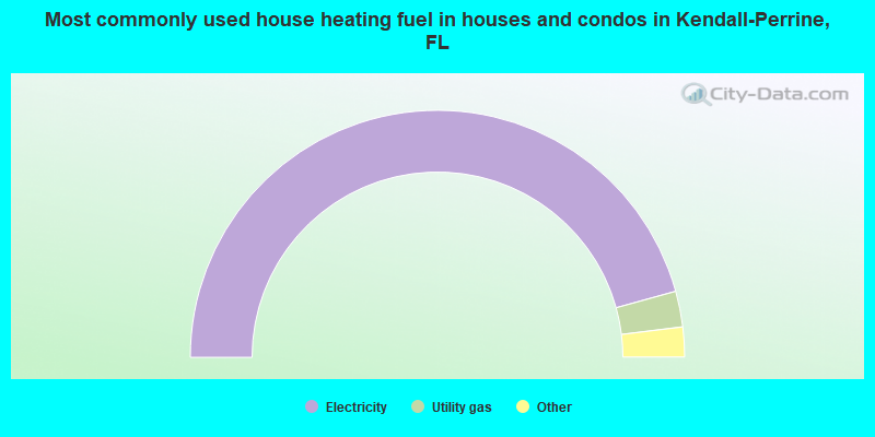
- 91.3%Electricity
- 4.7%Utility gas
- 2.7%No fuel used
- 0.9%Bottled, tank, or LP gas
- 0.2%Fuel oil, kerosene, etc.
- 0.1%Solar energy
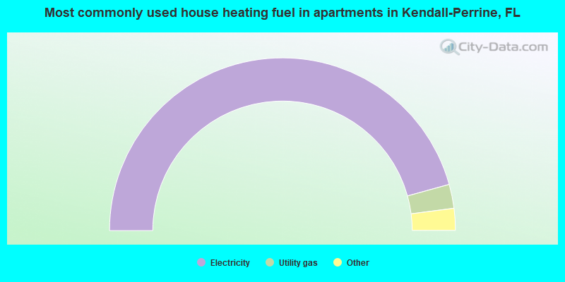
- 91.4%Electricity
- 4.5%Utility gas
- 2.7%No fuel used
- 1.2%Bottled, tank, or LP gas
- 0.2%Fuel oil, kerosene, etc.
Kendall-Perrine compared to Florida state average:
- Median household income above state average.
- Median house value above state average.
- Unemployed percentage significantly below state average.
- Foreign-born population percentage significantly below state average.
- Renting percentage significantly below state average.
- Length of stay since moving in significantly above state average.
- Number of rooms per house significantly below state average.
- House age significantly below state average.
- Institutionalized population percentage significantly above state average.
- Percentage of population with a bachelor's degree or higher above state average.
Kendall-Perrine, FL compared to other similar cities:
Kendall-Perrine on our top lists:
- #3 on the list of "Top 101 cities with largest percentage of males in industries: miscellaneous durable goods merchant wholesalers (population 50,000+)"
- #3 on the list of "Top 101 cities with largest percentage of males in industries: jewelry, luggage, and leather goods stores (population 50,000+)"
- #3 on the list of "Top 101 cities with largest percentage of females in occupations: secondary school teachers (population 50,000+)"
- #3 on the list of "Top 101 cities with largest percentage of males in industries: miscellaneous nondurable goods merchant wholesalers (population 50,000+)"
- #4 on the list of "Top 101 cities with largest percentage of males in occupations: lawyers (population 50,000+)"
- #5 on the list of "Top 101 cities with largest percentage of males in occupations: architects, surveyors, and cartographers (population 50,000+)"
- #5 on the list of "Top 101 cities with largest percentage of males in occupations: physicians and surgeons (population 50,000+)"
- #6 on the list of "Top 101 cities with largest percentage of males in industries: health care (population 50,000+)"
- #6 on the list of "Top 101 cities with largest percentage of females in industries: private households (population 50,000+)"
- #7 on the list of "Top 101 cities with largest percentage of females in industries: miscellaneous durable goods merchant wholesalers (population 50,000+)"
- #7 on the list of "Top 101 cities with largest percentage of males in occupations: financial managers (population 50,000+)"
- #8 on the list of "Top 101 cities with largest percentage of females in industries: alcoholic beverages merchant wholesalers (population 50,000+)"
- #8 on the list of "Top 101 cities with largest percentage of females in occupations: lawyers (population 50,000+)"
- #8 on the list of "Top 101 cities with largest percentage of females in industries: clothing and accessories, including shoe, stores (population 50,000+)"
- #10 on the list of "Top 101 cities with largest percentage of males in industries: electrical and electronic goods merchant wholesalers (population 50,000+)"
- #11 on the list of "Top 101 cities with largest percentage of females in industries: air transportation (population 50,000+)"
- #12 on the list of "Top 101 cities with largest percentage of females in industries: lumber and other construction materials merchant wholesalers (population 50,000+)"
- #12 on the list of "Top 101 cities with largest percentage of males in industries: air transportation (population 50,000+)"
- #12 on the list of "Top 101 cities with largest percentage of females in industries: miscellaneous nondurable goods merchant wholesalers (population 50,000+)"
- #12 on the list of "Top 101 cities with largest percentage of males in industries: water transportation (population 50,000+)"
- #53 (33156) on the list of "Top 101 zip codes with the most offices of lawyers in 2005"
- #95 (33156) on the list of "Top 101 zip codes with the highest 2012 average taxable interest for individuals (pop 5,000+)"
- #2 on the list of "Top 101 counties with the highest ground withdrawal of fresh water for public supply"
- #8 on the list of "Top 101 counties with the most Evangelical Protestant congregations"
- #9 on the list of "Top 101 counties with the most Black Protestant adherents"
- #11 on the list of "Top 101 counties with the highest total withdrawal of fresh water for public supply (pop. 50,000+)"
- #12 on the list of "Top 101 counties with the most Evangelical Protestant adherents (pop. 50,000+)"