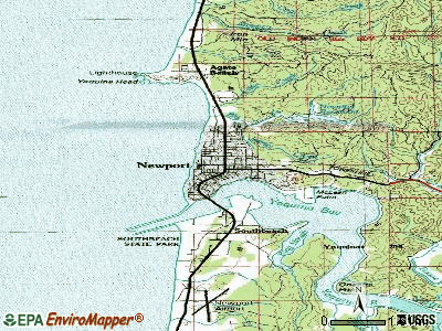
Newport, Oregon

Newport: Newport Bay Bridge at sunset

Newport: Port Dock One - Newport, Oregon

Newport: Ominous Clouds
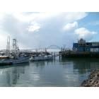
Newport: October Newport bay front
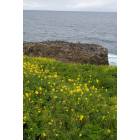
Newport: Newport, OR - Yaquina Head bird colony

Newport: Lighthouse Oregon Coast - Newport
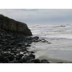
Newport: Waves Hitting Rocks

Newport: Newport Bay Bridge - Newport, Oregon
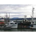
Newport: Boats at Bay

Newport: Yaquina Bay Bridge in Newport, Oregon

Newport: Yaquina Bay Bridge Newport Oregon
- see
45
more - add
your


Submit your own pictures of this city and show them to the world
- OSM Map
- General Map
- Google Map
- MSN Map
Population change since 2000: +9.2%
 |
| Males: 5,014 | |
| Females: 5,398 |
| Median resident age: | 48.6 years |
| Oregon median age: | 40.5 years |
| Newport: | $56,779 |
| OR: | $75,657 |
Estimated per capita income in 2022: $34,078 (it was $20,580 in 2000)
Newport city income, earnings, and wages data
Estimated median house or condo value in 2022: $419,733 (it was $132,100 in 2000)
| Newport: | $419,733 |
| OR: | $475,600 |
Mean prices in 2022: all housing units: $460,182; detached houses: $506,716; townhouses or other attached units: $494,705; in 2-unit structures: $667,337; in 3-to-4-unit structures: $797,731; in 5-or-more-unit structures: $280,633; mobile homes: $196,054; occupied boats, rvs, vans, etc.: $83,556
Median gross rent in 2022: $1,083.
(15.5% for White Non-Hispanic residents, 40.3% for Black residents, 15.5% for Hispanic or Latino residents, 13.2% for American Indian residents, 15.8% for other race residents, 11.7% for two or more races residents)
Detailed information about poverty and poor residents in Newport, OR


Compare current foreclosures near Newport, OR:
| Photo | Address | Area | Beds / Baths | Price | Details |
|---|---|---|---|---|---|

|
#1
NE 62nd St
Newport, OR 97365
|
1,863 sq. feet
|
2 baths 2 beds |
show details | |

|
#2
SW Smith Ct
Newport, OR 97365
|
1,568 sq. feet
|
1 baths 2 beds |
show details | |

|
#3
NE 70th Dr
Newport, OR 97365
|
1,813 sq. feet
|
2 baths 4 beds |
show details | |

|
#4
NE Coos St
Newport, OR 97365
|
1,260 sq. feet
|
1 baths 3 beds |
show details | |

|
#5
NE 7th St # B
Newport, OR 97365
|
- sq. feet
|
- baths - beds |
show details | |

|
#6
SW 2nd St Unit 1847
Newport, OR 97365
|
- sq. feet
|
- baths - beds |
show details | |

|
#7
NE 70th St
Newport, OR 97365
|
- sq. feet
|
- baths - beds |
show details | |

|
#8
SE Bay Blvd Unit 140
Newport, OR 97365
|
- sq. feet
|
- baths - beds |
show details | |

|
#9
S Crestline Dr
Waldport, OR 97394
|
1,208 sq. feet
|
2 baths 3 beds |
$315,000
|
show details |

|
#10
SE Loren Ln
Toledo, OR 97391
|
1,188 sq. feet
|
2 baths 2 beds |
show details |
| Photo | Address | Area | Beds / Baths | Price | Details |
|---|---|---|---|---|---|

|
#11
S Highway 101
Depoe Bay, OR 97341
|
1,120 sq. feet
|
1 baths 2 beds |
show details | |

|
#12
SW Tenas St
Siletz, OR 97380
|
- sq. feet
|
1 baths 3 beds |
show details | |

|
#13
Seagrove Loop
Lincoln City, OR 97367
|
2,011 sq. feet
|
2 baths 3 beds |
show details | |

|
#14
NW Pacific Way
Waldport, OR 97394
|
1,404 sq. feet
|
2 baths 2 beds |
show details | |

|
#15
SE Bird Ave
Waldport, OR 97394
|
1,208 sq. feet
|
2 baths 3 beds |
show details | |

|
#16
SE Ball Blvd
Waldport, OR 97394
|
1,398 sq. feet
|
2 baths 2 beds |
show details | |

|
#17
N Deer Hill Dr
Waldport, OR 97394
|
1,692 sq. feet
|
2 baths 3 beds |
show details | |

|
#18
Happy Valley Rd
Toledo, OR 97391
|
1,924 sq. feet
|
2 baths 3 beds |
show details | |

|
#19
SW Pine Ave
Depoe Bay, OR 97341
|
1,762 sq. feet
|
2 baths 3 beds |
show details | |

|
#20
SE Swan Ave
Siletz, OR 97380
|
1,288 sq. feet
|
1 baths 3 beds |
show details |
| Photo | Address | Area | Beds / Baths | Price | Details |
|---|---|---|---|---|---|

|
#21
S Bay Rd
Toledo, OR 97391
|
1,890 sq. feet
|
2 baths 3 beds |
show details | |

|
#22
SE 4th St
Toledo, OR 97391
|
1,368 sq. feet
|
1 baths 3 beds |
show details | |

|
#23
SE 97th Ct
South Beach, OR 97366
|
1,287 sq. feet
|
1 baths 3 beds |
show details | |

|
#24
N Main St Apt 4
Toledo, OR 97391
|
- sq. feet
|
- baths - beds |
show details | |

|
#25
Siletz Hwy
Siletz, OR 97380
|
- sq. feet
|
- baths - beds |
show details | |

|
#26
SE Eagle View Ln
Waldport, OR 97394
|
- sq. feet
|
- baths - beds |
show details | |

|
#27
SW Range Dr
Waldport, OR 97394
|
- sq. feet
|
- baths - beds |
show details | |

|
#28
E Alsea Hwy
Waldport, OR 97394
|
1,650 sq. feet
|
- baths - beds |
show details | |

|
#29
El Pino Ave
Lincoln City, OR 97367
|
- sq. feet
|
- baths - beds |
show details | |

|
Check over 1 million property listings on Foreclosure.com!
|
browse all offers | |||


- 7,71874.6%White alone
- 1,72116.6%Hispanic
- 5905.7%Two or more races
- 1771.7%Asian alone
- 520.5%Black alone
- 490.5%American Indian alone
- 20.02%Native Hawaiian and Other
Pacific Islander alone
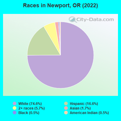
Races in Newport detailed stats: ancestries, foreign born residents, place of birth
According to our research of Oregon and other state lists, there were 6 registered sex offenders living in Newport, Oregon as of April 26, 2024.
The ratio of all residents to sex offenders in Newport is 1,737 to 1.
Type |
2009 |
2010 |
2011 |
2012 |
2013 |
2014 |
2015 |
2017 |
2018 |
2019 |
2020 |
2021 |
2022 |
|---|---|---|---|---|---|---|---|---|---|---|---|---|---|
| Murders (per 100,000) | 0 (0.0) | 0 (0.0) | 0 (0.0) | 0 (0.0) | 0 (0.0) | 1 (9.9) | 0 (0.0) | 0 (0.0) | 1 (9.4) | 1 (9.3) | 0 (0.0) | 0 (0.0) | 0 (0.0) |
| Rapes (per 100,000) | 8 (80.1) | 11 (110.1) | 16 (158.5) | 9 (89.7) | 9 (89.7) | 6 (59.1) | 3 (29.6) | 4 (38.2) | 9 (84.2) | 11 (102.1) | 11 (100.5) | 6 (53.3) | 6 (56.2) |
| Robberies (per 100,000) | 4 (40.0) | 6 (60.1) | 4 (39.6) | 6 (59.8) | 3 (29.9) | 10 (98.5) | 2 (19.7) | 0 (0.0) | 7 (65.5) | 3 (27.8) | 2 (18.3) | 4 (35.6) | 2 (18.7) |
| Assaults (per 100,000) | 27 (270.2) | 22 (220.2) | 25 (247.6) | 31 (308.8) | 34 (339.0) | 29 (285.7) | 18 (177.3) | 1 (9.6) | 22 (205.9) | 32 (297.1) | 19 (173.5) | 35 (311.2) | 32 (300.0) |
| Burglaries (per 100,000) | 67 (670.5) | 64 (640.7) | 49 (485.4) | 94 (936.3) | 91 (907.4) | 102 (1,005) | 84 (827.5) | 4 (38.2) | 53 (496.1) | 21 (194.9) | 26 (237.4) | 45 (400.1) | 36 (337.5) |
| Thefts (per 100,000) | 363 (3,633) | 301 (3,013) | 327 (3,239) | 390 (3,885) | 502 (5,005) | 481 (4,738) | 275 (2,709) | 28 (267.6) | 323 (3,023) | 277 (2,571) | 279 (2,548) | 306 (2,721) | 258 (2,419) |
| Auto thefts (per 100,000) | 26 (260.2) | 16 (160.2) | 23 (227.8) | 14 (139.5) | 16 (159.5) | 24 (236.4) | 20 (197.0) | 1 (9.6) | 16 (149.8) | 28 (259.9) | 16 (146.1) | 25 (222.3) | 19 (178.1) |
| Arson (per 100,000) | 3 (30.0) | 1 (10.0) | 7 (69.3) | 6 (59.8) | 1 (10.0) | 5 (49.3) | 4 (39.4) | 0 (0.0) | 15 (140.4) | 4 (37.1) | 6 (54.8) | 8 (71.1) | 6 (56.2) |
| City-Data.com crime index | 343.1 | 328.4 | 370.0 | 383.5 | 425.1 | 432.4 | 247.1 | 46.6 | 314.6 | 305.3 | 250.8 | 270.2 | 245.2 |
The City-Data.com crime index weighs serious crimes and violent crimes more heavily. Higher means more crime, U.S. average is 246.1. It adjusts for the number of visitors and daily workers commuting into cities.
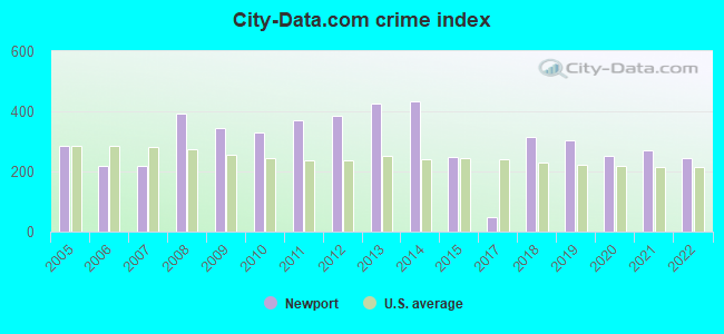
Crime rate in Newport detailed stats: murders, rapes, robberies, assaults, burglaries, thefts, arson
Full-time law enforcement employees in 2021, including police officers: 23 (16 officers - 16 male; 0 female).
| Officers per 1,000 residents here: | 1.42 |
| Oregon average: | 1.48 |
 Recent articles from our blog. Our writers, many of them Ph.D. graduates or candidates, create easy-to-read articles on a wide variety of topics.


 | Raising a family in Coos Bay vs Newport (30 replies) |
| Relocating to Newport or surrounding area (31 replies) |
| Questions about Newport (18 replies) |
| realtor recommendations for Newport? (36 replies) |
| Love the look of Newport OR, but the Crime rate--yipes!!? (14 replies) |
| Florence Vs Newport - Hispanic Issues and Tolerance (16 replies) |
Latest news from Newport, OR collected exclusively by city-data.com from local newspapers, TV, and radio stations
Ancestries: German (13.3%), European (12.3%), English (8.4%), Irish (6.9%), American (6.0%), Italian (3.1%).
Current Local Time: PST time zone
Incorporated in 1882
Elevation: 177 feet
Land area: 8.88 square miles.
Population density: 1,172 people per square mile (low).
711 residents are foreign born (4.9% Latin America, 1.3% Asia).
| This city: | 6.9% |
| Oregon: | 9.8% |
Median real estate property taxes paid for housing units with mortgages in 2022: $4,161 (0.9%)
Median real estate property taxes paid for housing units with no mortgage in 2022: $3,832 (1.0%)
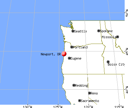
Nearest city with pop. 50,000+: Salem, OR  (54.3 miles , pop. 136,924).
Nearest city with pop. 200,000+: Northwest Clackamas, OR (87.7 miles , pop. 224,220).
Nearest city with pop. 1,000,000+: Los Angeles, CA (790.0 miles , pop. 3,694,820).
Nearest cities:
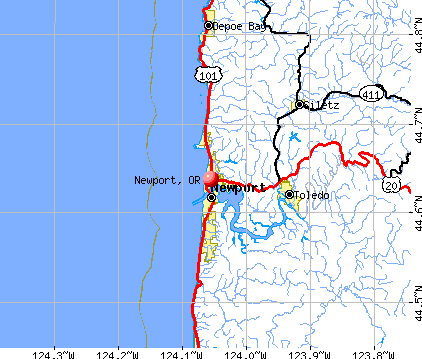
), ), Latitude: 44.64 N, Longitude: 124.05 W
Daytime population change due to commuting: +2,749 (+26.6%)
Workers who live and work in this city: 3,012 (71.0%)
Area code: 541

Newport tourist attractions:
- Hatfield Marine Science Center - Newport, OR - a center designed to educate people about science
- Seal Rock State Recreation Site - Newport, OR - a recreation site that is the natural habitat for marine life
- Oregon Coast Aquarium - Newport, Oregon - large aquarium with aviary in Oregon
- Yaquina Bay Lighthouse, Newport, OR
Newport, Oregon accommodation & food services, waste management - Economy and Business Data
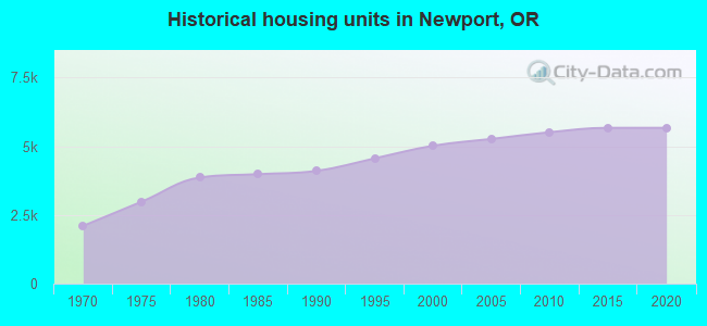
Single-family new house construction building permits:
- 2022: 11 buildings, average cost: $315,300
- 2021: 8 buildings, average cost: $385,500
- 2020: 10 buildings, average cost: $346,800
- 2019: 16 buildings, average cost: $186,500
- 2018: 20 buildings, average cost: $143,700
- 2017: 15 buildings, average cost: $229,300
- 2016: 13 buildings, average cost: $229,300
- 2015: 24 buildings, average cost: $193,100
- 2014: 22 buildings, average cost: $206,200
- 2013: 22 buildings, average cost: $206,200
- 2012: 21 buildings, average cost: $206,200
- 2011: 18 buildings, average cost: $206,200
- 2010: 20 buildings, average cost: $206,200
- 2009: 5 buildings, average cost: $284,800
- 2008: 27 buildings, average cost: $211,600
- 2007: 49 buildings, average cost: $211,600
- 2006: 54 buildings, average cost: $211,600
- 2005: 55 buildings, average cost: $211,600
- 2004: 39 buildings, average cost: $193,400
- 2003: 22 buildings, average cost: $179,200
- 2002: 12 buildings, average cost: $192,200
- 2001: 15 buildings, average cost: $143,200
- 2000: 15 buildings, average cost: $111,900
- 1999: 22 buildings, average cost: $147,200
- 1998: 23 buildings, average cost: $146,900
- 1997: 21 buildings, average cost: $121,000
| Here: | 4.6% |
| Oregon: | 3.9% |
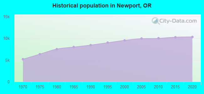
Population change in the 1990s: +880 (+10.2%).
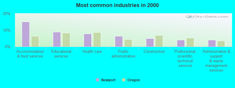
- Accommodation & food services (15.0%)
- Educational services (8.9%)
- Health care (7.8%)
- Public administration (6.3%)
- Construction (4.9%)
- Professional, scientific, technical services (4.2%)
- Administrative & support & waste management services (4.1%)
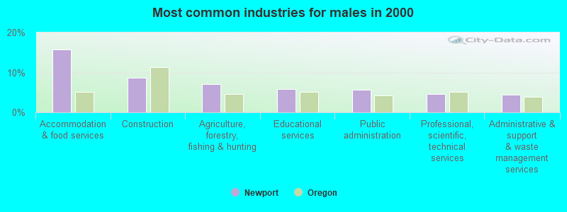
- Accommodation & food services (15.7%)
- Construction (8.8%)
- Agriculture, forestry, fishing & hunting (7.0%)
- Educational services (5.9%)
- Public administration (5.6%)
- Professional, scientific, technical services (4.6%)
- Administrative & support & waste management services (4.4%)
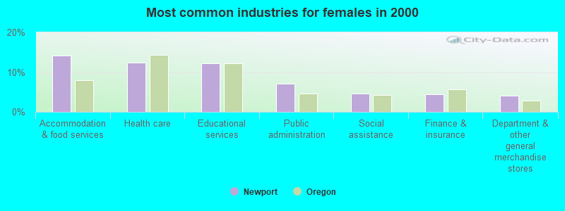
- Accommodation & food services (14.2%)
- Health care (12.5%)
- Educational services (12.2%)
- Public administration (7.1%)
- Social assistance (4.6%)
- Finance & insurance (4.4%)
- Department & other general merchandise stores (4.1%)

- Other sales and related occupations, including supervisors (6.6%)
- Other management occupations, except farmers and farm managers (5.8%)
- Building and grounds cleaning and maintenance occupations (5.2%)
- Retail sales workers, except cashiers (4.4%)
- Cooks and food preparation workers (3.9%)
- Preschool, kindergarten, elementary, and middle school teachers (3.2%)
- Sales representatives, services, wholesale and manufacturing (2.9%)
- Building and grounds cleaning and maintenance occupations (6.1%)
- Other management occupations, except farmers and farm managers (5.7%)
- Cooks and food preparation workers (5.7%)
- Fishing, hunting, and forestry occupations (5.1%)
- Other sales and related occupations, including supervisors (4.3%)
- Retail sales workers, except cashiers (3.9%)
- Electrical equipment mechanics and other installation, maintenance, and repair workers, including supervisors (3.7%)

- Other sales and related occupations, including supervisors (9.2%)
- Other management occupations, except farmers and farm managers (5.9%)
- Retail sales workers, except cashiers (4.8%)
- Other office and administrative support workers, including supervisors (4.8%)
- Waiters and waitresses (4.6%)
- Supervisors and other personal care and service workers, except child care workers (4.5%)
- Building and grounds cleaning and maintenance occupations (4.2%)
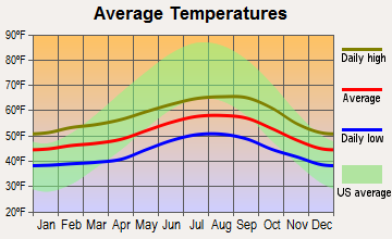
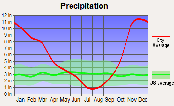
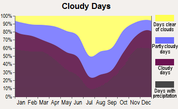
Average climate in Newport, Oregon
Based on data reported by over 4,000 weather stations
|
|

Earthquake activity:
Newport-area historical earthquake activity is significantly above Oregon state average. It is 1990% greater than the overall U.S. average.On 1/31/1922 at 13:17:28, a magnitude 7.6 (7.6 UK, Class: Major, Intensity: VIII - XII) earthquake occurred 282.8 miles away from the city center
On 8/17/1991 at 22:17:14, a magnitude 7.1 (6.2 MB, 7.1 MS, 7.1 MW, 6.8 ML, Depth: 8.4 mi) earthquake occurred 214.3 miles away from Newport center
On 4/13/1949 at 19:55:42, a magnitude 7.0 (7.0 UK) earthquake occurred 195.5 miles away from the city center, causing $80,000,000 total damage
On 11/8/1980 at 10:27:34, a magnitude 7.2 (6.2 MB, 7.2 MS, 7.2 MW, 7.0 ML) earthquake occurred 244.3 miles away from the city center
On 6/15/2005 at 02:50:54, a magnitude 7.2 (7.2 MW, Depth: 9.9 mi) earthquake occurred 250.5 miles away from Newport center
On 7/13/1991 at 02:50:14, a magnitude 6.9 (6.2 MB, 6.9 MS, 6.8 MW, 6.7 ML, Depth: 6.8 mi, Class: Strong, Intensity: VII - IX) earthquake occurred 189.0 miles away from Newport center
Magnitude types: body-wave magnitude (MB), local magnitude (ML), surface-wave magnitude (MS), moment magnitude (MW)
Natural disasters:
The number of natural disasters in Lincoln County (18) is near the US average (15).Major Disasters (Presidential) Declared: 16
Emergencies Declared: 1
Causes of natural disasters: Floods: 11, Storms: 7, Landslides: 6, Mudslides: 6, Winter Storms: 6, Winds: 3, Fire: 1, Heavy Rain: 1, Hurricane: 1, Snow: 1, Tsunami Wave: 1, Other: 1 (Note: some incidents may be assigned to more than one category).
Hospitals and medical centers in Newport:
Airports and heliports located in Newport:
- Newport Municipal Airport (ONP) (Runways: 2, Air Taxi Ops: 1,400, Itinerant Ops: 10,950, Local Ops: 3,650, Military Ops: 3,600)
- Samaritan Pacific Communities Hospital Heliport (8OR9)
Colleges/Universities in Newport:
Colleges/universities with over 2000 students nearest to Newport:
- Oregon State University (about 39 miles; Corvallis, OR; Full-time enrollment: 23,206)
- Western Oregon University (about 43 miles; Monmouth, OR; FT enrollment: 5,131)
- Linn-Benton Community College (about 47 miles; Albany, OR; FT enrollment: 4,511)
- Willamette University (about 55 miles; Salem, OR; FT enrollment: 2,551)
- Chemeketa Community College (about 58 miles; Salem, OR; FT enrollment: 10,746)
- University of Oregon (about 64 miles; Eugene, OR; FT enrollment: 23,329)
- Lane Community College (about 67 miles; Eugene, OR; FT enrollment: 6,373)
Public high school in Newport:
- NEWPORT HIGH SCHOOL (Students: 659, Location: 322 NE EADS ST, Grades: 9-12)
Public elementary/middle schools in Newport:
- SAM CASE ELEMENTARY SCHOOL (Students: 475, Location: 459 NE 12TH ST, Grades: KG-3)
- ISAAC NEWTON MAGNET SCHOOL (Students: 106, Location: 825 NE 7TH ST, Grades: 7-8)
- NEWPORT INTERMEDIATE SCHOOL (Location: 825 NE 7TH ST, Grades: 4-6)
- NEWPORT PREPARATORY ACADEMY (Location: 322 NE EADS ST, Grades: 7-8)
Private elementary/middle school in Newport:
Libraries in Newport:
- NEWPORT PUBLIC LIBRARY (Operating income: $896,256; Location: 35 NW NYE ST; 69,173 books; 8,152 audio materials; 5,660 video materials; 27 state licensed databases; 2 other licensed databases; 182 print serial subscriptions; 1 electronic serial subscriptions)
- LINCOLN COUNTY LIBRARY DISTRICT (Operating income: $487,995; Location: 1247 NW GROVE, #2; 18,689 books; 5,746 audio materials; 1,730 video materials; 27 state licensed databases; 2 other licensed databases; 25 print serial subscriptions; 1 electronic serial subscriptions)
Points of interest:
Notable locations in Newport: Lincoln County Rodeo and Fairgrounds (A), Newport Water Treatment Plant (B), Newport Wastewater Treatment Plant (C), Embarcadero Marina Resort Docks (D), Bay Street Tie Up Boat Dock (E), Port of Newport Marina and RV Park Boat Ramp North (F), Greyhound and Valley Retriever Bus Depot (G), Lincoln County Transit (H), Port of Newport Marina and RV Park Boat Ramp South (I), Port Docks Bay Front (J), Red Cross Blood Services (K), Lincoln County Public Health Department (L), United States Coast Guard Motor Lifeboat Station Yaquina Bay (M), Oregon Coast History Center (N), Pacific West Ambulance (O), Newport Fire Department Station 1 (P), Newport Fire Department Station 10 (Q), Oregon Coast Community College Library (R), Red Cross Lincoln District (S), United States Coast Guard Air Facility Newport (T). Display/hide their locations on the map
Churches in Newport include: Lighthouse Vineyard Christian Fellowship (A), Newport Foursquare Church (B). Display/hide their locations on the map
Creeks: Henderson Creek (A), Hurbert Creek (B), Anderson Creek (C), Olson Creek (D), Jeffries Creek (E), Little Creek (F), Lucky Gap Creek (G), Bains Creek (H). Display/hide their locations on the map
Parks in Newport include: Agate Beach State Park (1), Frank Wade Park (2), Yaquina Bay State Recreation Site (3), South Beach State Park (4). Display/hide their locations on the map
Beach: Nye Beach (A). Display/hide its location on the map
Tourist attractions: Crackers Family Food (Museums; 250 Southwest Bay Boulevard) (1), Lincoln County Historical Society (Museums; 545 Southwest 9th Street) (2), Mariner Square (Museums; 250 Southwest Bay Boulevard) (3), Oregon Undersea Gardens (Cultural Attractions- Events- & Facilities; 250 Southwest Bay Boulevard) (4), Ripley's Believe It Or Not (Historical Places & Services; 250 Sw Bay Blvd) (5), Marine Science Center Hatfield OSU - Director's Office (Cultural Attractions- Events- & Facilities; 2030 Southeast Marine Science Drive) (6), Marine Science Center Hatfield OSU - Aquarium Visitor Center (Cultural Attractions- Events- & Facilities; 2030 Southeast Marine Science Drive) (7), Wax Works (Cultural Attractions- Events- & Facilities; 250 Southwest Bay Boulevard) (8), Marine Science Center Hatfield OSU - Extension Sea Grant Education (Aquariums; 2030 Southeast Marine Science Drive) (9). Display/hide their approximate locations on the map
Hotels: La Quinta Inn & Suites Newport (45 Southeast 32nd Street) (1), Moolack Shores Motel (8835 North Coast Highway) (2), Shilo Oceanfront Resort (536 S.W. Elizabeth) (3), Hawthorn Inns & Suites - Newport (45 SE 32nd St) (4), Newport City Center Motel (538 Southwest Coast Highway) (5), Ocean House B & B (4920 Northwest Woody Way) (6), Little Creek Cove (3641 Northwest Oceanview Drive) (7), Elizabeth St Inn (232 Southwest Elizabeth Street) (8), Rookie's Pub and Starfish Grill (3019 North Coast Highway) (9). Display/hide their approximate locations on the map
Courts: Lincoln County - Teen Court (753 Northwest Brook Street) (1), Newport City - City Hall- Municipal Court Clerk (20 Southeast 2nd Street) (2). Display/hide their approximate locations on the map
Birthplace of: Rick Bartow - Artist, Ko Yada - College basketball player (Harvard Crimson), Nathan Ball - Pole vaulter.
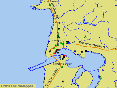
Drinking water stations with addresses in Newport and their reported violations in the past:
NEWPORT, CITY OF (Address: 2810 NE BIG CREEK RD , Population served: 9,900, Surface water):Past monitoring violations:OPRD ELLMAKER STATE PARK (Population served: 400, Groundwater):
- Monitoring of Treatment (SWTR-Filter) - In JUL-2012. Follow-up actions: St Compliance achieved (SEP-04-2012), St Violation/Reminder Notice (OCT-01-2012)
- Monitoring, Turbidity (Enhanced SWTR) - In JUL-2012, Contaminant: IESWTR. Follow-up actions: St Compliance achieved (SEP-04-2012), St Violation/Reminder Notice (OCT-01-2012)
- Monitoring of Treatment (SWTR-Filter) - In JUL-2012. Follow-up actions: St Compliance achieved (SEP-04-2012), St Violation/Reminder Notice (OCT-01-2012)
- Monitoring and Reporting (DBP) - In JUL-2009, Contaminant: Total Haloacetic Acids (HAA5). Follow-up actions: St Violation/Reminder Notice (DEC-28-2009), St Compliance achieved (JAN-07-2010)
- Monitoring and Reporting (DBP) - In JUL-2009, Contaminant: TTHM. Follow-up actions: St Violation/Reminder Notice (DEC-28-2009), St Compliance achieved (JAN-07-2010)
Past monitoring violations:OPRD BEVERLY BEACH STATE PARK (Population served: 200, Surface water):
- Failure to Conduct Assessment Monitoring - Between JAN-2012 and DEC-2012, Contaminant: COLIPHAGE. Follow-up actions: St Violation/Reminder Notice (FEB-04-2013), St Compliance achieved (APR-12-2013)
- One routine major monitoring violation
- One minor monitoring violation
Past monitoring violations:BEVERLY BEACH WATER DISTRICT (Population served: 150, Surface water):
- Monitoring, Source Water (LT2) - In JUL-01-2008, Contaminant: LT2ESWTR. Follow-up actions: Fed Compliance achieved (AUG-25-2008)
Past monitoring violations:CARMEL BEACH WATER DISTRICT (Population served: 61, Groundwater):
- Monitoring, Turbidity (Enhanced SWTR) - In OCT-2013, Contaminant: IESWTR. Follow-up actions: St Compliance achieved (DEC-04-2013)
- Monitoring of Treatment (SWTR-Filter) - In OCT-2013. Follow-up actions: St Compliance achieved (DEC-04-2013)
- Monitoring of Treatment (SWTR-Filter) - In OCT-2013. Follow-up actions: St Compliance achieved (DEC-04-2013)
- Monitoring, Turbidity (Enhanced SWTR) - In MAR-2005, Contaminant: IESWTR. Follow-up actions: State No Longer Subject to Rule (DEC-25-2010)
Past health violations:BAY HILLS WATER ASSOCIATION (Population served: 45, Surface water):Past monitoring violations:
- MCL, Monthly (TCR) - In JUL-2013, Contaminant: Coliform. Follow-up actions: St Public Notif received (JUL-12-2013), St Public Notif requested (JUL-16-2013), St Compliance achieved (SEP-11-2013)
- Monitoring of Treatment (SWTR-Unfilt/GWR) - In SEP-2012, Contaminant: GROUNDWATER RULE. Follow-up actions: St Violation/Reminder Notice (OCT-29-2012), St Compliance achieved (NOV-02-2012)
- Monitoring, Source Water (GWR) - In AUG-01-2010, Contaminant: E. COLI. Follow-up actions: St Violation/Reminder Notice (SEP-27-2010), State No Longer Subject to Rule (JUN-29-2011)
- Monitoring, Source Water (GWR) - In AUG-01-2010, Contaminant: E. COLI. Follow-up actions: St Violation/Reminder Notice (SEP-27-2010), State No Longer Subject to Rule (JUN-29-2011)
- Monitoring, Repeat Major (TCR) - In AUG-2010, Contaminant: Coliform (TCR). Follow-up actions: St Public Notif requested (SEP-22-2010), St Violation/Reminder Notice (SEP-27-2010), St Compliance achieved (OCT-13-2010)
- Monitoring, Source Water (GWR) - In APR-01-2010, Contaminant: E. COLI. Follow-up actions: St Violation/Reminder Notice (MAY-24-2010), State No Longer Subject to Rule (JUN-29-2011)
- 3 routine major monitoring violations
- One minor monitoring violation
- 2 other older monitoring violations
Past monitoring violations:SAWYERS LANDING RV PARK (Population served: 25, Surface water):
- Monitoring of Treatment (SWTR-Filter) - In FEB-2012. Follow-up actions: St Violation/Reminder Notice (MAR-27-2012), St Compliance achieved (APR-02-2012)
- Monitoring of Treatment (SWTR-Filter) - In FEB-2012. Follow-up actions: St Violation/Reminder Notice (MAR-27-2012), St Compliance achieved (APR-02-2012)
- Monitoring, Turbidity (Enhanced SWTR) - In FEB-2012, Contaminant: IESWTR. Follow-up actions: St Violation/Reminder Notice (MAR-27-2012), St Compliance achieved (APR-02-2012)
Past health violations:Past monitoring violations:
- Failure to Filter (SWTR) - In JUL-01-2012. Follow-up actions: St Public Notif requested (JUL-26-2012), St Formal NOV issued (JUL-27-2012), St Violation/Reminder Notice (OCT-01-2012), St Compliance achieved (OCT-01-2012)
- Treatment Technique (SWTR and GWR) - In JUN-2012. Follow-up actions: St Public Notif requested (JUL-20-2012), St Formal NOV issued (JUL-27-2012), St Violation/Reminder Notice (JUL-30-2012), St Compliance achieved (OCT-01-2012)
- Treatment Technique (SWTR and GWR) - In DEC-2010. Follow-up actions: St Public Notif requested (JAN-20-2011), St Violation/Reminder Notice (JAN-24-2011), St AO (w/penalty) issued (APR-19-2011), St Compliance achieved (JUN-12-2012)
- Treatment Technique (SWTR and GWR) - In NOV-2010. Follow-up actions: St Public Notif requested (DEC-22-2010), St Violation/Reminder Notice (JAN-24-2011), St AO (w/penalty) issued (APR-19-2011), St Compliance achieved (JUN-12-2012)
- Treatment Technique (SWTR and GWR) - In OCT-2010. Follow-up actions: St Public Notif requested (DEC-22-2010), St Violation/Reminder Notice (JAN-24-2011), St AO (w/penalty) issued (APR-19-2011), St Compliance achieved (JUN-12-2012)
- Treatment Technique (SWTR and GWR) - In SEP-2010. Follow-up actions: St Public Notif requested (DEC-22-2010), St Violation/Reminder Notice (JAN-24-2011), St AO (w/penalty) issued (APR-19-2011), St Compliance achieved (JUN-12-2012)
- 7 other older health violations
- Monitoring of Treatment (SWTR-Filter) - In MAY-2014
- Monitoring of Treatment (SWTR-Filter) - In MAY-2014
- Monitoring of Treatment (SWTR-Filter) - In MAY-2014
- Monitoring of Treatment (SWTR-Filter) - In OCT-2013. Follow-up actions: St Compliance achieved (DEC-04-2013)
- Monitoring of Treatment (SWTR-Filter) - In OCT-2013. Follow-up actions: St Compliance achieved (DEC-04-2013)
- 4 routine major monitoring violations
- 53 other older monitoring violations
| This city: | 2.2 people |
| Oregon: | 2.5 people |
| This city: | 56.9% |
| Whole state: | 63.4% |
| This city: | 8.5% |
| Whole state: | 8.0% |
Likely homosexual households (counted as self-reported same-sex unmarried-partner households)
- Lesbian couples: 0.5% of all households
- Gay men: 0.2% of all households
People in group quarters in Newport in 2010:
- 174 people in local jails and other municipal confinement facilities
- 45 people in nursing facilities/skilled-nursing facilities
- 30 people in emergency and transitional shelters (with sleeping facilities) for people experiencing homelessness
- 29 people in other noninstitutional facilities
- 11 people in military barracks and dormitories (nondisciplinary)
- 9 people in group homes intended for adults
- 8 people in group homes for juveniles (non-correctional)
- 6 people in residential treatment centers for adults
- 4 people in correctional facilities intended for juveniles
People in group quarters in Newport in 2000:
- 89 people in local jails and other confinement facilities (including police lockups)
- 70 people in nursing homes
- 57 people in other noninstitutional group quarters
- 22 people in crews of maritime vessels
- 18 people in unknown juvenile institutions
- 13 people in other types of correctional institutions
- 7 people in military barracks, etc.
- 5 people in other group homes
Banks with branches in Newport (2011 data):
- West Coast Bank: Newport Main at 506 Southwest Coast Highway, branch established on 1998/12/31; Newport North Branch at 2350 North Coast Highway, branch established on 1978/08/21. Info updated 2010/09/16: Bank assets: $2,424.8 mil, Deposits: $1,925.6 mil, headquarters in Lake Oswego, OR, positive income, Commercial Lending Specialization, 63 total offices, Holding Company: West Coast Bancorp
- U.S. Bank National Association: Yaquina Bay Branch at 400 East Olive Street, branch established on 1981/01/22. Info updated 2012/01/30: Bank assets: $330,470.8 mil, Deposits: $236,091.5 mil, headquarters in Cincinnati, OH, positive income, 3121 total offices, Holding Company: U.S. Bancorp
- Umpqua Bank: Newport Branch at 1250 North Coast Highway, branch established on 1996/05/29. Info updated 2011/09/02: Bank assets: $11,556.7 mil, Deposits: $9,325.3 mil, headquarters in Roseburg, OR, positive income, Commercial Lending Specialization, 193 total offices, Holding Company: Umpqua Holdings Corporation
- JPMorgan Chase Bank, National Association: Newport at 150 Ne 2oth St, branch established on 1986/06/30. Info updated 2011/11/10: Bank assets: $1,811,678.0 mil, Deposits: $1,190,738.0 mil, headquarters in Columbus, OH, positive income, International Specialization, 5577 total offices, Holding Company: Jpmorgan Chase & Co.
- Oregon Coast Bank: at 909 Se Bay Boulevard, branch established on 2002/07/08. Info updated 2006/11/03: Bank assets: $164.7 mil, Deposits: $147.6 mil, local headquarters, positive income, 5 total offices, Holding Company: Oregon Coast Bancshares, Inc.
- Bank of the West: Newport Branch at 248 S.W. Coast Highway, branch established on 1934/11/30. Info updated 2009/11/16: Bank assets: $62,408.3 mil, Deposits: $43,995.2 mil, headquarters in San Francisco, CA, positive income, 647 total offices, Holding Company: Bnp Paribas
- Washington Federal: Newport Branch at 644 Sw Coast Hwy Ste A, branch established on 1934/03/01. Info updated 2011/12/19: Bank assets: $13,653.0 mil, Deposits: $8,905.8 mil, headquarters in Seattle, WA, positive income, Mortgage Lending Specialization, 174 total offices
- Bank of America, National Association: Newport Branch at 10 South Coast Highway, branch established on 1890/01/01. Info updated 2009/11/18: Bank assets: $1,451,969.3 mil, Deposits: $1,077,176.8 mil, headquarters in Charlotte, NC, positive income, 5782 total offices, Holding Company: Bank Of America Corporation
For population 15 years and over in Newport:
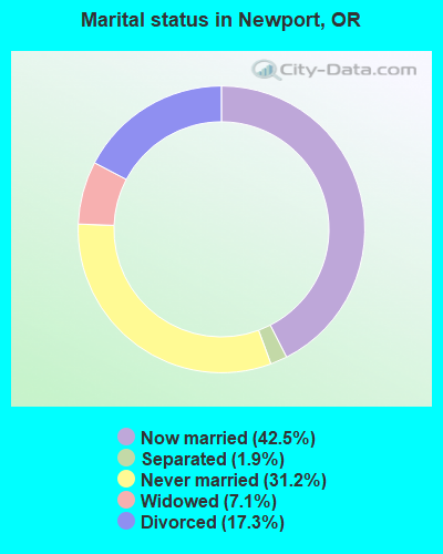
- Never married: 31.2%
- Now married: 42.5%
- Separated: 1.9%
- Widowed: 7.1%
- Divorced: 17.3%
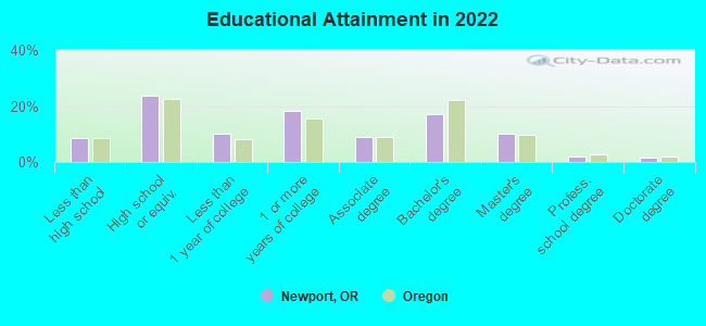
For population 25 years and over in Newport:
- High school or higher: 91.1%
- Bachelor's degree or higher: 30.2%
- Graduate or professional degree: 13.4%
- Unemployed: 9.1%
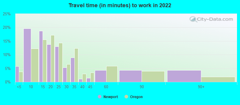
- Mean travel time to work (commute): 14.6 minutes

| Here: | 11.8 |
| Oregon average: | 11.6 |
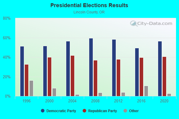
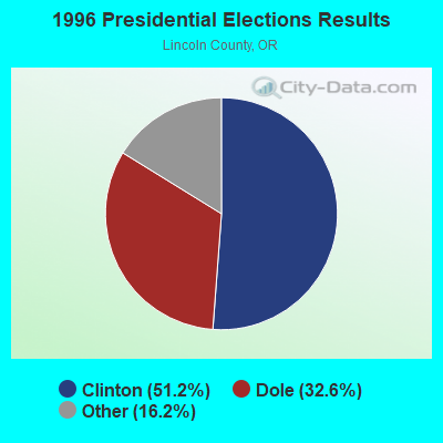
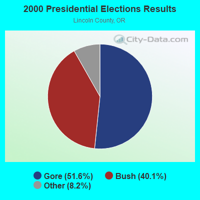

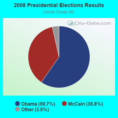

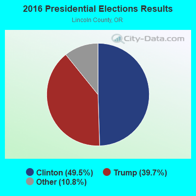
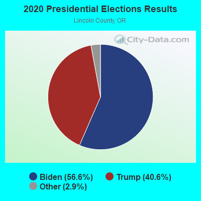
Graphs represent county-level data. Detailed 2008 Election Results
Religion statistics for Newport, OR (based on Lincoln County data)
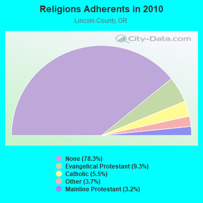
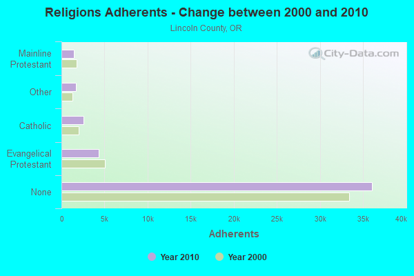
| Religion | Adherents | Congregations |
|---|---|---|
| Evangelical Protestant | 4,303 | 52 |
| Catholic | 2,524 | 4 |
| Other | 1,689 | 10 |
| Mainline Protestant | 1,464 | 12 |
| None | 36,054 | - |
Food Environment Statistics:
| Here: | 4.59 / 10,000 pop. |
| Oregon: | 2.03 / 10,000 pop. |
| Lincoln County: | 0.44 / 10,000 pop. |
| State: | 0.33 / 10,000 pop. |
| Lincoln County: | 2.40 / 10,000 pop. |
| Oregon: | 2.01 / 10,000 pop. |
| Lincoln County: | 2.84 / 10,000 pop. |
| Oregon: | 1.69 / 10,000 pop. |
| Lincoln County: | 24.25 / 10,000 pop. |
| Oregon: | 9.93 / 10,000 pop. |
| Here: | 10.0% |
| Oregon: | 7.4% |
| Lincoln County: | 27.1% |
| Oregon: | 25.6% |
| This county: | 17.1% |
| Oregon: | 14.2% |
Health and Nutrition:
| Newport: | 49.3% |
| Oregon: | 49.6% |
| Newport: | 45.5% |
| Oregon: | 46.8% |
| This city: | 28.6 |
| Oregon: | 28.5 |
| Newport: | 21.7% |
| State: | 21.2% |
| This city: | 10.8% |
| Oregon: | 10.1% |
| Here: | 6.8 |
| Oregon: | 6.8 |
| Here: | 34.2% |
| State: | 33.3% |
| Here: | 54.7% |
| Oregon: | 56.5% |
| Newport: | 76.7% |
| Oregon: | 78.7% |
More about Health and Nutrition of Newport, OR Residents
| Local government employment and payroll (March 2022) | |||||
| Function | Full-time employees | Monthly full-time payroll | Average yearly full-time wage | Part-time employees | Monthly part-time payroll |
|---|---|---|---|---|---|
| Police Protection - Officers | 23 | $193,571 | $100,994 | 0 | $0 |
| Parks and Recreation | 14 | $74,214 | $63,612 | 36 | $41,437 |
| Water Supply | 11 | $64,251 | $70,092 | 1 | $321 |
| Firefighters | 11 | $95,533 | $104,218 | 19 | $7,220 |
| Local Libraries | 10 | $48,603 | $58,324 | 4 | $8,230 |
| Other and Unallocable | 9 | $56,774 | $75,699 | 1 | $3,278 |
| Sewerage | 8 | $48,417 | $72,626 | 0 | $0 |
| Financial Administration | 7 | $45,384 | $77,801 | 2 | $1,336 |
| Police - Other | 6 | $32,088 | $64,176 | 0 | $0 |
| Airports | 5 | $24,018 | $57,643 | 1 | $194 |
| Streets and Highways | 3 | $22,350 | $89,400 | 0 | $0 |
| Other Government Administration | 3 | $30,392 | $121,568 | 0 | $0 |
| Solid Waste Management | 1 | $5,983 | $71,796 | 0 | $0 |
| Judicial and Legal | 0 | $0 | 1 | $2,479 | |
| Totals for Government | 111 | $741,578 | $80,171 | 65 | $64,495 |
Newport government finances - Expenditure in 2021 (per resident):
- Construction - General - Other: $2,437,000 ($234.06)
Sewerage: $1,879,000 ($180.46)
Water Utilities: $573,000 ($55.03)
Regular Highways: $420,000 ($40.34)
Air Transportation: $251,000 ($24.11)
- Current Operations - Police Protection: $4,207,000 ($404.05)
Sewerage: $3,529,000 ($338.94)
Water Utilities: $3,173,000 ($304.74)
Central Staff Services: $2,499,000 ($240.01)
Local Fire Protection: $2,355,000 ($226.18)
General - Other: $2,045,000 ($196.41)
Parks and Recreation: $1,885,000 ($181.04)
Libraries: $1,121,000 ($107.66)
Air Transportation: $668,000 ($64.16)
Regular Highways: $517,000 ($49.65)
Protective Inspection and Regulation - Other: $473,000 ($45.43)
Housing and Community Development: $309,000 ($29.68)
Financial Administration: $75,000 ($7.20)
Parking Facilities: $5,000 ($0.48)
- General - Interest on Debt: $841,000 ($80.77)
- Other Capital Outlay - Air Transportation: $193,000 ($18.54)
Protective Inspection and Regulation - Other: $26,000 ($2.50)
Parks and Recreation: $12,000 ($1.15)
- Water Utilities - Interest on Debt: $1,208,000 ($116.02)
Newport government finances - Revenue in 2021 (per resident):
- Charges - Sewerage: $5,678,000 ($545.33)
Parks and Recreation: $661,000 ($63.48)
Air Transportation: $278,000 ($26.70)
Parking Facilities: $27,000 ($2.59)
Other: $26,000 ($2.50)
Regular Highways: $17,000 ($1.63)
- Federal Intergovernmental - Other: $144,000 ($13.83)
Air Transportation: $83,000 ($7.97)
- Local Intergovernmental - Other: $684,000 ($65.69)
- Miscellaneous - Interest Earnings: $574,000 ($55.13)
Fines and Forfeits: $129,000 ($12.39)
Rents: $102,000 ($9.80)
General Revenue - Other: $69,000 ($6.63)
Donations From Private Sources: $2,000 ($0.19)
- Revenue - Water Utilities: $4,824,000 ($463.31)
- State Intergovernmental - Highways: $894,000 ($85.86)
General Local Government Support: $712,000 ($68.38)
Other: $442,000 ($42.45)
Housing and Community Development: $66,000 ($6.34)
- Tax - Property: $13,373,000 ($1284.38)
Other Selective Sales: $3,966,000 ($380.91)
Public Utilities Sales: $1,521,000 ($146.08)
Other License: $523,000 ($50.23)
Motor Fuels Sales: $183,000 ($17.58)
Newport government finances - Debt in 2021 (per resident):
- Long Term Debt - Beginning Outstanding - Unspecified Public Purpose: $53,140,000 ($5103.73)
Outstanding Unspecified Public Purpose: $48,489,000 ($4657.03)
Retired Unspecified Public Purpose: $4,651,000 ($446.70)
Newport government finances - Cash and Securities in 2021 (per resident):
- Other Funds - Cash and Securities: $31,713,000 ($3045.81)
| Businesses in Newport, OR | ||||
| Name | Count | Name | Count | |
|---|---|---|---|---|
| AT&T | 1 | MasterBrand Cabinets | 5 | |
| Best Western | 1 | Mazda | 1 | |
| Burger King | 1 | McDonald's | 1 | |
| Chevrolet | 1 | Nike | 1 | |
| Comfort Inn | 1 | Nissan | 1 | |
| Decora Cabinetry | 1 | Payless | 1 | |
| Econo Lodge | 1 | Quiznos | 1 | |
| FedEx | 2 | RadioShack | 1 | |
| Ford | 1 | Rite Aid | 1 | |
| GNC | 1 | Rodeway Inn | 1 | |
| Goodwill | 1 | Sears | 1 | |
| H&R Block | 1 | Staples | 1 | |
| Holiday Inn | 1 | Starbucks | 2 | |
| Honda | 1 | Toyota | 1 | |
| Kroger | 2 | U-Haul | 1 | |
| La Quinta | 1 | UPS | 5 | |
| La-Z-Boy | 1 | Vons | 1 | |
| Lane Furniture | 1 | Walmart | 1 | |
Strongest AM radio stations in Newport:
- KNPT (1310 AM; 5 kW; NEWPORT, OR; Owner: YAOUINA BAY COMMUNICATIONS, INC.)
- KPPT (1230 AM; 1 kW; TOLEDO, OR; Owner: AGPAL BROADCASTING INC)
- KDUN (1030 AM; 50 kW; REEDSPORT, OR; Owner: PAMPLIN BROADCASTING-OREGON, INC.)
- KPNW (1120 AM; 50 kW; EUGENE, OR; Owner: CAPSTAR TX LIMITED PARTNERSHIP)
- KPOJ (620 AM; 50 kW; PORTLAND, OR; Owner: CITICASTERS LICENSES, L.P.)
- KXL (750 AM; 50 kW; PORTLAND, OR; Owner: ROSE CITY RADIO CORPORATION)
- KORC (820 AM; 1 kW; WALDPORT, OR; Owner: TOTAL ACCESS, INC.)
- KPAM (860 AM; 50 kW; TROUTDALE, OR; Owner: PAMPLIN BROADCASTING-OREGON, INC.)
- KZTU (660 AM; 10 kW; JUNCTION CITY, OR; Owner: PAMPLIN BROADCASTING-OREGON, INC.)
- KEX (1190 AM; 50 kW; PORTLAND, OR; Owner: CITICASTERS LICENSES, L.P.)
- KOTK (1080 AM; 50 kW; PORTLAND, OR; Owner: FISHER BROADCASTING - PORTLAND RADIO, L.L.C.)
- KOAC (550 AM; 5 kW; CORVALLIS, OR; Owner: OREGON PUBLIC BROADCASTING)
- KKSN (1520 AM; 50 kW; OREGON CITY, OR; Owner: ENTERCOM PORTLAND LICENSE, LLC)
Strongest FM radio stations in Newport:
- K204CP (88.7 FM; TOLEDO, OR; Owner: PENSACOLA CHRISTIAN COLLEGE, INC.)
- KSND (95.1 FM; LINCOLN CITY, OR; Owner: RADIO BEAM, LLC)
- KWPB-LP (98.7 FM; NEWPORT, OR; Owner: WINDS OF PRAISE BROADCASTING)
- K207BO (89.3 FM; NEWPORT, OR; Owner: FAMILY STATIONS, INC.)
- KYTE (102.7 FM; NEWPORT, OR; Owner: YAQUINA BAY COMMUNICATIONS, INC.)
- KCRF-FM (96.7 FM; LINCOLN CITY, OR; Owner: PACIFIC WEST BROADCASTING, INC.)
- KSHL (97.5 FM; GLENEDEN BEACH, OR; Owner: STEPHANIE LINN)
- KNCU (92.7 FM; NEWPORT, OR; Owner: PACIFIC WEST BROADCASTING, INC.)
- KPPT-FM (100.7 FM; TOLEDO, OR; Owner: AGPAL BROADCASTING INC.)
- KLCO (90.5 FM; NEWPORT, OR; Owner: LANE COMMUNITY COLLEGE)
- KDUK-FM (104.7 FM; FLORENCE, OR; Owner: CAPSTAR TX LIMITED PARTNERSHIP)
- KFLY (101.5 FM; CORVALLIS, OR; Owner: CITICASTERS LICENSES, L.P.)
- K228DT (93.5 FM; HAPPY HOLLOW, OR; Owner: OREGON PUBLIC BROADCASTING)
- K220CX (91.9 FM; NEWPORT, OR; Owner: OREGON ST. BD. OF HIGHER EDUCATION)
- K207BX (89.3 FM; EUGENE, OR; Owner: PENSACOLA CHRISTIAN COLLEGE, INC.)
- KWVZ (91.5 FM; FLORENCE, OR; Owner: OREGON STATE BOARD OF HIGHER ED.)
- K203BT (88.5 FM; EUGENE, OR; Owner: CALVARY CHAPEL OF TWIN FALLS, INC.)
- K214CI (90.7 FM; EUGENE, OR; Owner: EDUCATIONAL MEDIA FOUNDATION)
- KHPE (107.9 FM; ALBANY, OR; Owner: INTEGRITY MEDIA, INC.)
- K264AA (100.7 FM; CORVALLIS, ETC., OR; Owner: THE KBOO FOUNDATION)
TV broadcast stations around Newport:
- KORS-LP (Channel 55; SALEM, OR; Owner: WATCHTV, INC.)
- K29AZ (Channel 29; NEWPORT, OR; Owner: KING BROADCASTING COMPANY)
- K38CZ (Channel 38; LINCOLN CITY/NEWPORT, OR; Owner: EMMIS TELEVISION LICENSE CORPORATION)
- K42CZ (Channel 42; LINCOLN CITY, ETC., OR; Owner: FISHER BROADCASTING - PORTLAND TV, L.L.C.)
- K18FR (Channel 18; NEWPORT, OR; Owner: OREGON PUBLIC BROADCASTING)
- K15DS (Channel 15; NEWPORT, ETC., OR; Owner: MEREDITH CORPORATION)
- National Bridge Inventory (NBI) Statistics
- 18Number of bridges
- 607ft / 185mTotal length
- $66,075,000Total costs
- 84,787Total average daily traffic
- 5,089Total average daily truck traffic
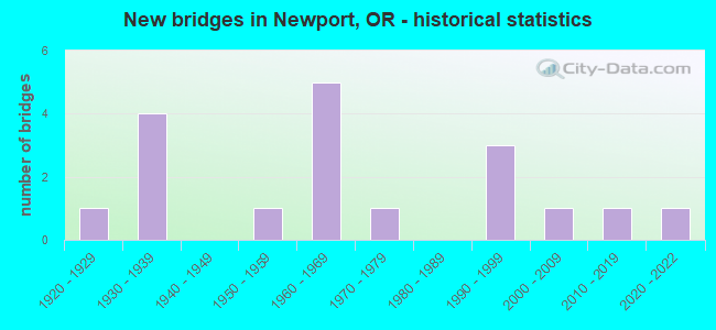
- New bridges - historical statistics
- 11920-1929
- 41930-1939
- 11950-1959
- 51960-1969
- 11970-1979
- 31990-1999
- 12000-2009
- 12010-2019
- 12020-2022
FCC Registered Antenna Towers: 55 (See the full list of FCC Registered Antenna Towers)
FCC Registered Private Land Mobile Towers: 2 (See the full list of FCC Registered Private Land Mobile Towers in Newport, OR)
FCC Registered Broadcast Land Mobile Towers: 35 (See the full list of FCC Registered Broadcast Land Mobile Towers)
FCC Registered Microwave Towers: 39 (See the full list of FCC Registered Microwave Towers in this town)
FCC Registered Paging Towers: 10 (See the full list of FCC Registered Paging Towers)
FCC Registered Maritime Coast & Aviation Ground Towers: 16 (See the full list of FCC Registered Maritime Coast & Aviation Ground Towers)
FCC Registered Amateur Radio Licenses: 195 (See the full list of FCC Registered Amateur Radio Licenses in Newport)
FAA Registered Aircraft: 25 (See the full list of FAA Registered Aircraft in Newport)
2002 - 2016 National Fire Incident Reporting System (NFIRS) incidents
- Fire incident types reported to NFIRS in Newport, OR
- 25237.3%Outside Fires
- 25137.1%Structure Fires
- 11216.6%Mobile Property/Vehicle Fires
- 619.0%Other
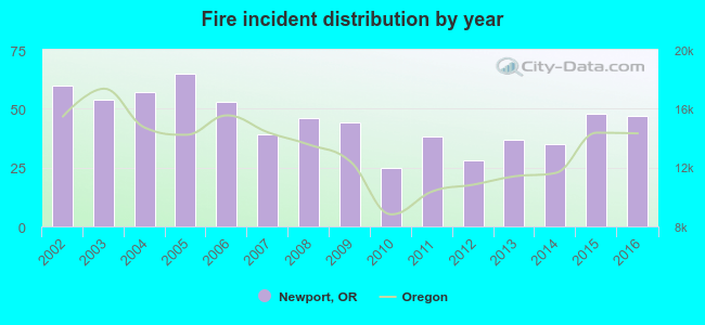 Based on the data from the years 2002 - 2016 the average number of fires per year is 45. The highest number of fire incidents - 65 took place in 2005, and the least - 25 in 2010. The data has a decreasing trend.
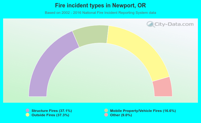 When looking into fire subcategories, the most incidents belonged to: Outside Fires (37.3%), and Structure Fires (37.1%).
Fire-safe hotels and motels in Newport, Oregon:
- Inn At Nye Beach, 729 NW Coast St, Newport, Oregon 97365 , Phone: (541) 265-2477, Fax: (541) 272-5018
- Comfort Inn, 531 SW Fall St, Newport, Oregon 97365 , Phone: (541) 265-6203, Fax: (541) 265-6623
- Whaler Motel, 155 SW Elizabeth, Newport, Oregon 97365 , Phone: (541) 265-9261, Fax: (503) 982-0355
- Best Western PLUS Agate Beach Inn, 3019 N Coast Hwy # 101, Newport, Oregon 97365 , Phone: (541) 265-9411, Fax: (541) 265-5342
- La Quinta Inn & Suites, 45 SE 32nd St, Newport, Oregon 97365 , Phone: (541) 867-7727, Fax: (541) 867-7728
- Elizabeth Street Inn, 232 SW Elizabeth St, Newport, Oregon 97365 , Phone: (541) 265-9400, Fax: (541) 265-9551
- Driftwood Motel, Inc, 7947 N Coast Hwy 101, Newport, Oregon 97365 , Phone: (541) 265-5738, Fax: (541) 265-5739
- Holiday Inn Express Newport, 135 SE 32nd St, Newport, Oregon 97365 , Phone: (541) 867-3377
- 5 other hotels and motels
| Most common first names in Newport, OR among deceased individuals | ||
| Name | Count | Lived (average) |
|---|---|---|
| John | 69 | 76.0 years |
| Mary | 66 | 79.1 years |
| William | 64 | 71.6 years |
| Robert | 64 | 71.0 years |
| Charles | 50 | 78.6 years |
| James | 47 | 71.0 years |
| Helen | 46 | 82.3 years |
| Margaret | 44 | 82.0 years |
| George | 42 | 71.9 years |
| Richard | 37 | 70.5 years |
| Most common last names in Newport, OR among deceased individuals | ||
| Last name | Count | Lived (average) |
|---|---|---|
| Smith | 38 | 78.2 years |
| Johnson | 30 | 74.0 years |
| Nelson | 21 | 80.9 years |
| Miller | 19 | 72.5 years |
| Martin | 17 | 75.1 years |
| Wilson | 17 | 77.3 years |
| Williams | 16 | 74.2 years |
| Davis | 16 | 77.2 years |
| Jones | 15 | 80.4 years |
| Brown | 15 | 75.5 years |
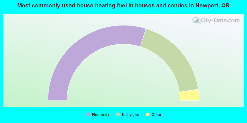
- 59.6%Electricity
- 35.6%Utility gas
- 3.6%Wood
- 0.7%Bottled, tank, or LP gas
- 0.3%No fuel used
- 0.2%Fuel oil, kerosene, etc.
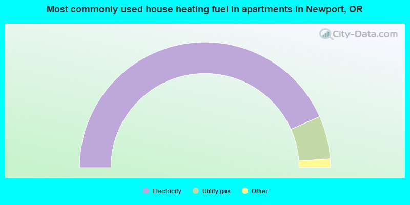
- 86.7%Electricity
- 11.1%Utility gas
- 1.1%Bottled, tank, or LP gas
- 1.0%No fuel used
Newport compared to Oregon state average:
- Black race population percentage significantly below state average.
- Median age above state average.
- Length of stay since moving in above state average.
- Institutionalized population percentage above state average.
Newport on our top lists:
- #8 on the list of "Top 101 cities with the largest percentage of people in crews of maritime vessels (population 1,000+)"
- #20 on the list of "Top 101 cities with the most users submitting photos to our site per 10,000 residents (population 5,000+)"
- #75 on the list of "Top 101 cities with the most local government spending on current operations of libraries per resident (population 10,000+)"

|
|
Total of 28 patent applications in 2008-2024.