Westport, Maine
Submit your own pictures of this town and show them to the world
- OSM Map
- General Map
- Google Map
- MSN Map
| Males: 381 | |
| Females: 390 |
| Median resident age: | 44.8 years |
| Maine median age: | 38.6 years |
Zip codes: 04578.
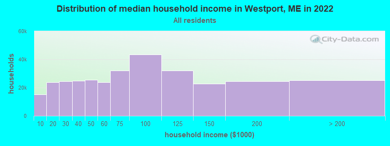
| Westport: | $71,551 |
| ME: | $69,543 |
Estimated per capita income in 2022: $46,916 (it was $21,623 in 2000)
Westport town income, earnings, and wages data
Estimated median house or condo value in 2022: $396,600 (it was $138,400 in 2000)
| Westport: | $396,600 |
| ME: | $290,600 |
Mean prices in 2022: all housing units: $415,956; detached houses: $442,502; townhouses or other attached units: $442,441; in 2-unit structures: $393,150; in 3-to-4-unit structures: $266,359; in 5-or-more-unit structures: $407,319; mobile homes: $150,042; occupied boats, rvs, vans, etc.: $76,651
Detailed information about poverty and poor residents in Westport, ME


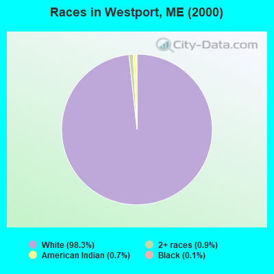
- 73298.3%White alone
- 70.9%Two or more races
- 50.7%American Indian alone
- 10.1%Black alone
Races in Westport detailed stats: ancestries, foreign born residents, place of birth
 Recent articles from our blog. Our writers, many of them Ph.D. graduates or candidates, create easy-to-read articles on a wide variety of topics.


 | Maine is calling and I'm answering (20 replies) |
| Different locations and wind... (2 replies) |
| Brunswick as a place to retire? (8 replies) |
| Unorganized Territories in Maine... (33 replies) |
| Relocation: Narrowing down on MidCoast (4 replies) |
| Falmouth area (14 replies) |
Latest news from Westport, ME collected exclusively by city-data.com from local newspapers, TV, and radio stations
Westport, ME City Guides:
Ancestries: English (32.2%), Irish (15.0%), German (10.9%), United States (9.0%), Scottish (7.9%), French (6.2%).
Current Local Time: EST time zone
Incorporated on 02/05/1828
Elevation: 98 feet
Land area: 8.74 square miles.
Population density: 88 people per square mile (very low).
23 residents are foreign born (1.3% Asia, 1.2% North America, 0.5% Europe).
| This town: | 3.1% |
| Maine: | 2.9% |
| Westport town: | 1.0% ($1,324) |
| Maine: | 1.5% ($1,417) |
Nearest city with pop. 50,000+: Portland, ME  (33.4 miles , pop. 64,249).
Nearest city with pop. 200,000+: Boston, MA (130.8 miles , pop. 589,141).
Nearest city with pop. 1,000,000+: Bronx, NY (300.9 miles , pop. 1,332,650).
Nearest cities:
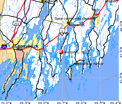
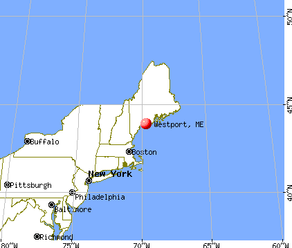
), ), ), Latitude: 43.92 N, Longitude: 69.70 W
Area code commonly used in this area: 207

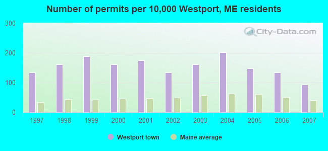
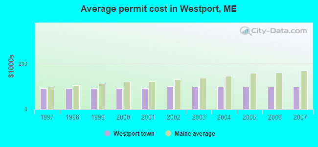
Single-family new house construction building permits:
- 2007: 7 buildings, average cost: $99,900
- 2006: 10 buildings, average cost: $99,900
- 2005: 11 buildings, average cost: $99,900
- 2004: 15 buildings, average cost: $99,900
- 2003: 12 buildings, average cost: $99,700
- 2002: 10 buildings, average cost: $101,500
- 2001: 13 buildings, average cost: $94,200
- 2000: 12 buildings, average cost: $94,200
- 1999: 14 buildings, average cost: $94,200
- 1998: 12 buildings, average cost: $94,200
- 1997: 10 buildings, average cost: $94,200
| Here: | 3.6% |
| Maine: | 3.4% |
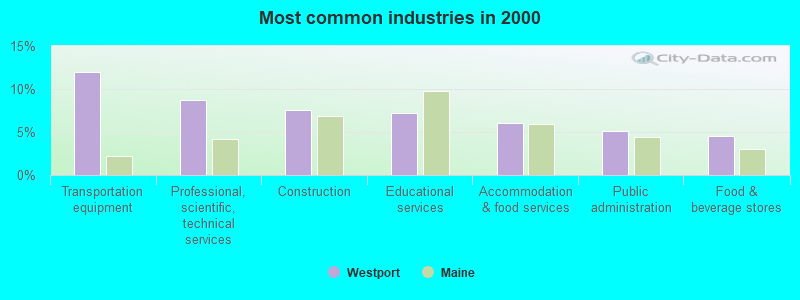
- Transportation equipment (12.0%)
- Professional, scientific, technical services (8.7%)
- Construction (7.5%)
- Educational services (7.2%)
- Accommodation & food services (6.0%)
- Public administration (5.1%)
- Food & beverage stores (4.5%)
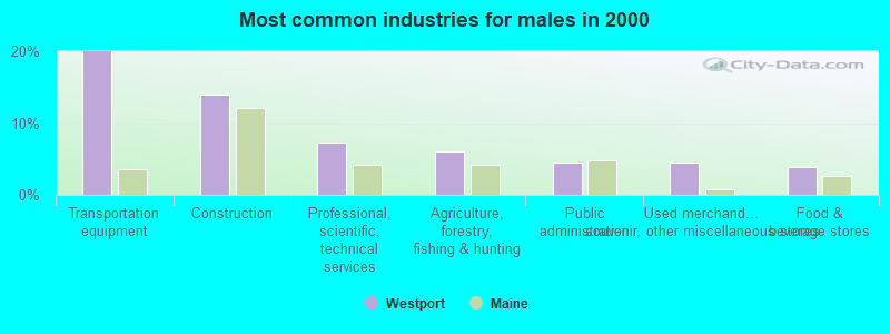
- Transportation equipment (20.0%)
- Construction (13.9%)
- Professional, scientific, technical services (7.2%)
- Agriculture, forestry, fishing & hunting (6.1%)
- Public administration (4.4%)
- Used merchandise, gift, novelty, souvenir, other miscellaneous stores (4.4%)
- Food & beverage stores (3.9%)

- Educational services (14.4%)
- Professional, scientific, technical services (10.5%)
- Accommodation & food services (8.5%)
- Health care (6.5%)
- Public administration (5.9%)
- Finance & insurance (5.9%)
- Food & beverage stores (5.2%)

- Other sales and related occupations, including supervisors (6.9%)
- Other management occupations, except farmers and farm managers (6.6%)
- Engineers (5.4%)
- Carpenters (4.5%)
- Secretaries and administrative assistants (3.9%)
- Material recording, scheduling, dispatching, and distributing workers (3.3%)
- Cashiers (3.3%)

- Engineers (10.0%)
- Carpenters (8.3%)
- Other sales and related occupations, including supervisors (7.2%)
- Other management occupations, except farmers and farm managers (6.1%)
- Material recording, scheduling, dispatching, and distributing workers (5.0%)
- Vehicle and mobile equipment mechanics, installers, and repairers (4.4%)
- Electricians (3.9%)

- Secretaries and administrative assistants (8.5%)
- Other management occupations, except farmers and farm managers (7.2%)
- Cashiers (7.2%)
- Other sales and related occupations, including supervisors (6.5%)
- Preschool, kindergarten, elementary, and middle school teachers (4.6%)
- Personal appearance workers (4.6%)
- Other office and administrative support workers, including supervisors (3.9%)
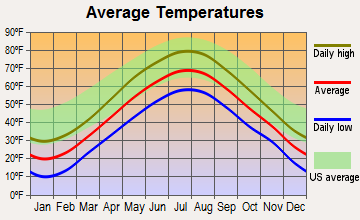
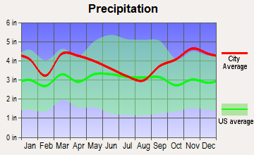
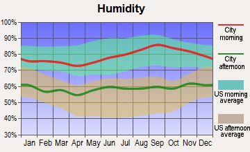
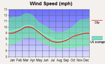
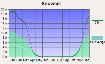
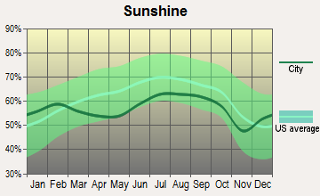
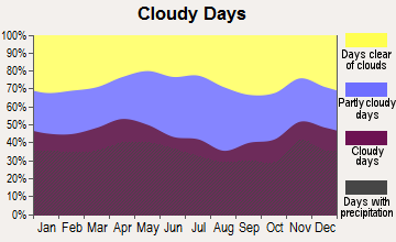
Average climate in Westport, Maine
Based on data reported by over 4,000 weather stations
(lower is better)
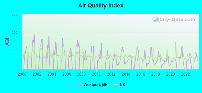
Air Quality Index (AQI) level in 2023 was 58.0. This is better than average.
| City: | 58.0 |
| U.S.: | 72.6 |
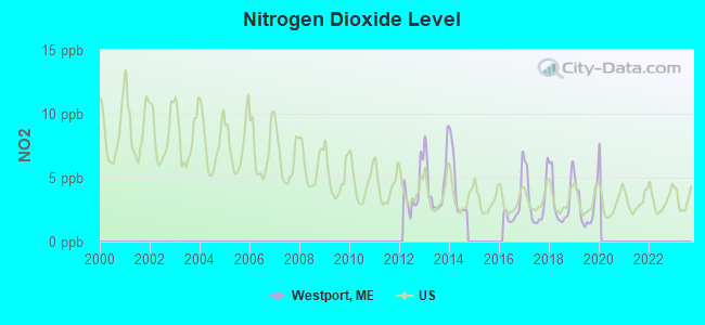
Nitrogen Dioxide (NO2) [ppb] level in 2019 was 2.80. This is significantly better than average. Closest monitor was 22.2 miles away from the city center.
| City: | 2.80 |
| U.S.: | 5.11 |
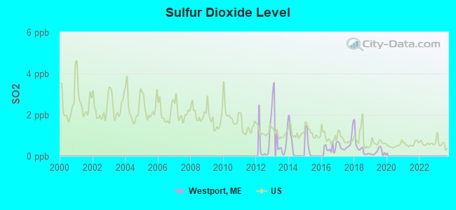
Sulfur Dioxide (SO2) [ppb] level in 2019 was 0.185. This is significantly better than average. Closest monitor was 5.8 miles away from the city center.
| City: | 0.185 |
| U.S.: | 1.515 |

Ozone [ppb] level in 2023 was 31.5. This is about average. Closest monitor was 2.6 miles away from the city center.
| City: | 31.5 |
| U.S.: | 33.3 |
Earthquake activity:
Westport-area historical earthquake activity is significantly above Maine state average. It is 76% smaller than the overall U.S. average.On 10/16/2012 at 23:12:25, a magnitude 4.7 (4.7 ML, Depth: 10.0 mi, Class: Light, Intensity: IV - V) earthquake occurred 52.8 miles away from Westport center
On 4/20/2002 at 10:50:47, a magnitude 5.3 (5.3 ML, Depth: 3.0 mi, Class: Moderate, Intensity: VI - VII) earthquake occurred 202.6 miles away from the city center
On 1/19/1982 at 00:14:42, a magnitude 4.7 (4.5 MB, 4.7 MD, 4.5 LG) earthquake occurred 99.4 miles away from the city center
On 4/20/2002 at 10:50:47, a magnitude 5.2 (5.2 MB, 4.2 MS, 5.2 MW, 5.0 MW) earthquake occurred 203.3 miles away from Westport center
On 10/7/1983 at 10:18:46, a magnitude 5.3 (5.1 MB, 5.3 LG, 5.1 ML) earthquake occurred 231.4 miles away from Westport center
On 2/26/1999 at 03:38:43, a magnitude 3.8 (3.8 LG, Depth: 2.0 mi, Class: Light, Intensity: II - III) earthquake occurred 40.0 miles away from Westport center
Magnitude types: regional Lg-wave magnitude (LG), body-wave magnitude (MB), duration magnitude (MD), local magnitude (ML), surface-wave magnitude (MS), moment magnitude (MW)
Natural disasters:
The number of natural disasters in Lincoln County (24) is greater than the US average (15).Major Disasters (Presidential) Declared: 19
Emergencies Declared: 4
Causes of natural disasters: Floods: 15, Storms: 11, Winter Storms: 4, Hurricanes: 2, Snows: 2, Winds: 2, Blizzard: 1, Heavy Rain: 1, Ice Storm: 1, Landslide: 1, Snowfall: 1, Tropical Storm: 1, Other: 2 (Note: some incidents may be assigned to more than one category).
Hospitals and medical centers near Westport:
- ST ANDREWS HOME HEALTH (Home Health Center, about 6 miles away; BOOTHBAY HARBOR, ME)
- ST ANDREWS HOSPITAL (LINCOLN COUNTY HEALTHCARE) Critical Access Hospitals (about 6 miles away; BOOTHBAY HARBOR, ME)
- WINSHIP GREEN NURSING CENTER (Nursing Home, about 7 miles away; BATH, ME)
- COASTAL DIALYSIS CENTER (Dialysis Facility, about 7 miles away; BATH, ME)
- COVE'S EDGE (Nursing Home, about 12 miles away; DAMARISCOTTA, ME)
- BRUNSWICK MANOR (Nursing Home, about 14 miles away; BRUNSWICK, ME)
- COMMUNITY HEALTH AND NURSING SERVICES (Home Health Center, about 15 miles away; BRUNSWICK, ME)
Colleges/universities with over 2000 students nearest to Westport:
- University of Maine at Augusta (about 30 miles; Augusta, ME; Full-time enrollment: 3,204)
- Southern Maine Community College (about 33 miles; South Portland, ME; FT enrollment: 4,666)
- University of Southern Maine (about 34 miles; Portland, ME; FT enrollment: 6,647)
- Saint Joseph's College of Maine (about 40 miles; Standish, ME; FT enrollment: 2,010)
- University of New England (about 47 miles; Biddeford, ME; FT enrollment: 4,539)
- University of Maine at Farmington (about 57 miles; Farmington, ME; FT enrollment: 2,036)
- Husson University (about 78 miles; Bangor, ME; FT enrollment: 2,421)
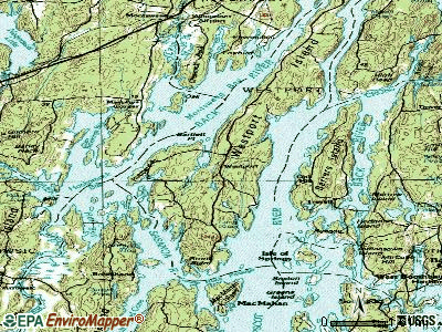
Points of interest:
Notable location: Westport Island Volunteer Fire Department (A). Display/hide its location on the map
Church in Westport: Westport Church (A). Display/hide its location on the map
Cemeteries: Greenleaf Cemetery (1), Tarbox Cemetery (2), Willis Harrington Cemetery (3), William Knight Cemetery (4), Tarbox Bailey Cemetery (5), Rhines Parsons Cemetery (6), Parsons Greenleaf Cemetery (7). Display/hide their locations on the map
Lake: Heal Pond (A). Display/hide its location on the map
Creek: Squam Creek (A). Display/hide its location on the map
Park in Westport: Porter Preserve (1). Display/hide its location on the map
Drinking water stations with addresses in Westport and their reported violations in the past:
SQUIRE TARBOX INN (Population served: 112, Groundwater):Past health violations:Past monitoring violations:
- MCL, Monthly (TCR) - In AUG-2013, Contaminant: Coliform. Follow-up actions: St Public Notif requested (AUG-19-2013), St Formal NOV issued (AUG-19-2013), St Compliance achieved (SEP-30-2013)
- MCL, Monthly (TCR) - In OCT-2012, Contaminant: Coliform. Follow-up actions: St Public Notif requested (OCT-12-2012), St Formal NOV issued (OCT-12-2012), St Public Notif received (DEC-26-2012), St Compliance achieved (MAY-13-2013)
- MCL, Monthly (TCR) - In AUG-2012, Contaminant: Coliform. Follow-up actions: St Public Notif requested (AUG-30-2012), St Formal NOV issued (AUG-30-2012), St Compliance achieved (MAY-13-2013), St Public Notif received (JUL-02-2013)
- MCL, Monthly (TCR) - In JUL-2012, Contaminant: Coliform. Follow-up actions: St Public Notif requested (AUG-03-2012), St Formal NOV issued (AUG-03-2012), St Public Notif received (AUG-29-2012), St Compliance achieved (MAY-13-2013)
- MCL, Monthly (TCR) - In NOV-2010, Contaminant: Coliform. Follow-up actions: St Public Notif requested (DEC-02-2010), St Formal NOV issued (DEC-02-2010), St Public Notif received (APR-11-2011), St Compliance achieved (AUG-26-2011)
- MCL, Monthly (TCR) - In OCT-2010, Contaminant: Coliform. Follow-up actions: St Public Notif requested (OCT-21-2010), St Formal NOV issued (OCT-21-2010), St Public Notif received (APR-11-2011), St Compliance achieved (AUG-26-2011)
- 5 routine major monitoring violations
- One regular monitoring violation
| This town: | 2.3 people |
| Maine: | 2.4 people |
| This town: | 72.0% |
| Whole state: | 66.1% |
| This town: | 5.7% |
| Whole state: | 7.3% |
Likely homosexual households (counted as self-reported same-sex unmarried-partner households)
- Lesbian couples: 0.3% of all households
- Gay men: 0.0% of all households
| This town: | 6.6% |
| Whole state: | 10.9% |
| This town: | 1.6% |
| Whole state: | 4.1% |
For population 15 years and over in Westport:
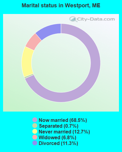
- Never married: 12.7%
- Now married: 68.5%
- Separated: 0.7%
- Widowed: 6.8%
- Divorced: 11.3%
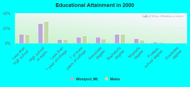
For population 25 years and over in Westport:
- High school or higher: 85.0%
- Bachelor's degree or higher: 25.0%
- Graduate or professional degree: 10.0%
- Unemployed: 7.2%
- Mean travel time to work (commute): 25.5 minutes
| Here: | 10.8 |
| Maine average: | 11.2 |
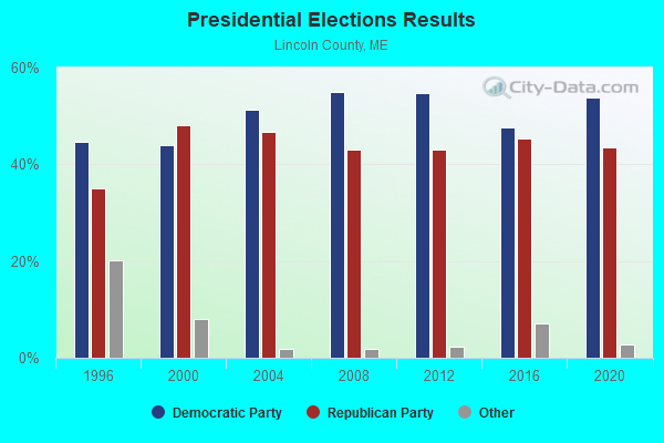
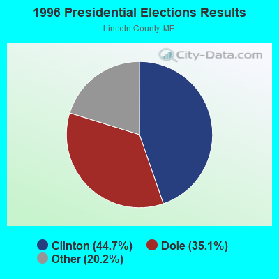
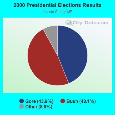


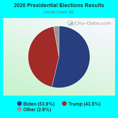
Graphs represent county-level data. Detailed 2008 Election Results
Religion statistics for Westport, ME (based on Lincoln County data)
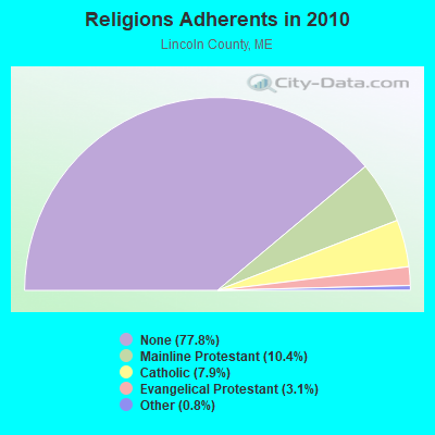

| Religion | Adherents | Congregations |
|---|---|---|
| Mainline Protestant | 3,586 | 29 |
| Catholic | 2,725 | 3 |
| Evangelical Protestant | 1,065 | 12 |
| Other | 279 | 4 |
| None | 26,802 | - |
Food Environment Statistics:
| Lincoln County: | 4.03 / 10,000 pop. |
| Maine: | 2.80 / 10,000 pop. |
| This county: | 2.59 / 10,000 pop. |
| State: | 2.20 / 10,000 pop. |
| This county: | 6.62 / 10,000 pop. |
| Maine: | 5.75 / 10,000 pop. |
| This county: | 13.23 / 10,000 pop. |
| Maine: | 11.02 / 10,000 pop. |
| Lincoln County: | 7.0% |
| Maine: | 8.2% |
| Lincoln County: | 21.9% |
| Maine: | 25.0% |
Strongest AM radio stations in Westport:
- WJTO (730 AM; 1 kW; BATH, ME; Owner: BLUE JEY BROADCASTING COMPANY)
- WFAU (1280 AM; 5 kW; GARDINER, ME; Owner: CAPSTAR TX LIMITED PARTNERSHIP)
- WGAN (560 AM; 5 kW; PORTLAND, ME; Owner: SAGA COMMUNICATIONS OF NEW ENGLAND, LLC)
- WMTW (870 AM; 10 kW; GORHAM, ME; Owner: RADIO PARTNERS OF MAINE, L.P.)
- WJJB (900 AM; 1 kW; BRUNSWICK, ME; Owner: ATLANTIC COAST RADIO, LLC)
- WRKO (680 AM; 50 kW; BOSTON, MA; Owner: ENTERCOM BOSTON LICENSE, LLC)
- WLAM (1470 AM; 5 kW; LEWISTON, ME; Owner: RADIO PARTNERS OF MAINE, L.P.)
- WTME (780 AM; 10 kW; RUMFORD, ME; Owner: MOUNTAIN VALLEY BROADCASTING, INC.)
- WZAN (970 AM; 5 kW; PORTLAND, ME; Owner: SAGA COMMUNICATIONS OF NEW ENGLAND, LLC)
- WLOB (1310 AM; 5 kW; PORTLAND, ME; Owner: ATLANTIC COAST RADIO, LLC)
- WEEI (850 AM; 50 kW; BOSTON, MA; Owner: ENTERCOM BOSTON LICENSE, LLC)
- WBZ (1030 AM; 50 kW; BOSTON, MA; Owner: INFINITY BROADCASTING OPERATIONS, INC.)
- WSKW (1160 AM; 10 kW; SKOWHEGAN, ME; Owner: MOUNTAIN WIRELESS, INCORPORATED)
Strongest FM radio stations in Westport:
- WCME (96.7 FM; BOOTHBAY HARBOR, ME; Owner: CAPSTAR TX LIMITED PARTNERSHIP)
- WCLZ (98.9 FM; BRUNSWICK, ME; Owner: CITADEL BROADCASTING COMPANY)
- WBCI (105.9 FM; BATH, ME; Owner: BLOUNT COMMUNICATIONS, INC.)
- WMEP (90.5 FM; CAMDEN, ME; Owner: MAINE PUBLIC BROADCASTING CORP.)
- WQSS (102.5 FM; CAMDEN, ME; Owner: CLEAR CHANNEL BROADCASTING LICENSES, INC.)
- WPKQ (103.7 FM; NORTH CONWAY, NH; Owner: CITADEL BROADCASTING COMPANY)
- WBLM (102.9 FM; PORTLAND, ME; Owner: CITADEL BROADCASTING COMPANY)
- WJJB-FM (95.5 FM; TOPSHAM, ME; Owner: ATLANTIC COAST RADIO, LLC)
- WHOM (94.9 FM; MT. WASHINGTON, NH; Owner: CITADEL BROADCASTING COMPANY)
- WMEA (90.1 FM; PORTLAND, ME; Owner: MAINE PUBLIC BROADCASTING CORPORATION)
- WTHT (107.5 FM; LEWISTON, ME; Owner: RADIO PARTNERS OF MAINE, L.P.)
- WCYI (93.9 FM; LEWISTON, ME; Owner: CITADEL BROADCASTING COMPANY)
- WJBQ (97.9 FM; PORTLAND, ME; Owner: CITADEL BROADCASTING COMPANY)
- WMCM (103.3 FM; ROCKLAND, ME; Owner: CLEAR CHANNEL BROADCASTING LICENSES, INC.)
- WMEK-FM (99.9 FM; AUBURN, ME; Owner: RADIO PARTNERS OF MAINE, L.P.)
- WBQX (106.9 FM; THOMASTON, ME; Owner: MARINER BROADCASTING LIMITED PARTNER)
- WYFP (91.9 FM; HARPSWELL, ME; Owner: BIBLE BROADCASTING NETWORK, INC.)
- WMTW-FM (106.7 FM; NORTH WINDHAM, ME; Owner: RADIO PARTNERS OF MAINE, L.P.)
- WPOR (101.9 FM; PORTLAND, ME; Owner: SAGA COMMUNICATIONS OF NEW ENGLAND, LLC)
- WMME-FM (92.3 FM; AUGUSTA, ME; Owner: CITADEL BROADCASTING COMPANY)
TV broadcast stations around Westport:
- WGME-TV (Channel 13; PORTLAND, ME; Owner: WGME LICENSEE, LLC)
- WPFO (Channel 23; WATERVILLE, ME; Owner: CMCG PORTLAND LICENSE LLC)
- WCBB (Channel 10; AUGUSTA, ME; Owner: MAINE PUBLIC BROADCASTING CORP.)
- WMTW-TV (Channel 8; POLAND SPRING, ME; Owner: WMTW BROADCAST GROUP, LLC)
- WCSH (Channel 6; PORTLAND, ME; Owner: PACIFIC AND SOUTHERN COMPANY, INC.)
- WPXT (Channel 51; PORTLAND, ME; Owner: HMW, INC.)
- WPME (Channel 35; LEWISTON, ME; Owner: KB PRIME MEDIA LLC)
FCC Registered Broadcast Land Mobile Towers:
1- 349 Main Road (Lat: 43.909750 Lon: -69.706417), Call Sign: WQCX431,
Assigned Frequencies: 158.325 MHz, Grant Date: 06/16/2005, Expiration Date: 06/16/2015, Cancellation Date: 08/22/2015, Certifier: Dennis Cromwell, Registrant: Yankee Communications, 935 Main Street, Clinton, ME 04927, Phone: (207) 453-2000, Fax: (866) 536-5243, Email:
FCC Registered Maritime Coast & Aviation Ground Towers:
1- Jewetts Cove (Lat: 43.867583 Lon: -69.712833), Type: Building, Overall height: 7 m, Call Sign: WHU985,
Assigned Frequencies: 156.450 MHz, 156.800 MHz, 156.975 MHz, Grant Date: 08/16/1994, Expiration Date: 08/16/1999, Cancellation Date: 05/06/2001, Registrant: Westport, Town Of, Rfd 2 Box 721, Westport, ME 04578
FCC Registered Amateur Radio Licenses:
1- Call Sign: KB1HBC, Licensee ID: L00381962, Grant Date: 07/24/2001, Expiration Date: 07/24/2011, Cancellation Date: 04/29/2003, Certifier: Walter B Mc Carty, Registrant: Walter B Mc Carty, 914 Main Rd, Westport, ME 04578
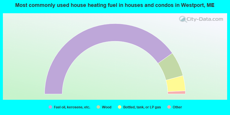
- 80.3%Fuel oil, kerosene, etc.
- 11.3%Wood
- 7.0%Bottled, tank, or LP gas
- 0.7%Utility gas
- 0.7%Electricity
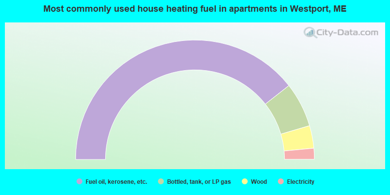
- 78.8%Fuel oil, kerosene, etc.
- 12.1%Bottled, tank, or LP gas
- 6.1%Wood
- 3.0%Electricity
Westport compared to Maine state average:
- Unemployed percentage below state average.
- Black race population percentage significantly below state average.
- Hispanic race population percentage significantly below state average.
- Renting percentage significantly below state average.
- Length of stay since moving in significantly above state average.
- Number of rooms per house significantly below state average.
- House age significantly below state average.
- Institutionalized population percentage significantly above state average.
- Number of college students below state average.

|
Total of 2 patent applications in 2008-2024.