Please register to participate in our discussions with 2 million other members - it's free and quick! Some forums can only be seen by registered members. After you create your account, you'll be able to customize options and access all our 15,000 new posts/day with fewer ads.
That's an interesting cluster of heat in the Mid-Atlantic (VA, MD, DE, Southeastern PA, and parts of NJ). Cuts off fairly abruptly in coastal and Northern NJ/NYC.
Yesterday was warm and dry here. Today is a little cooler (still a warm 70 F/21 C), there's a hint of humidity in the air.
Its the same here infact down on the se of gb there are inland places reaching 12/13c and then right on the coast it is 5c because the sea is 5c.
Yes, must be the wind or something. Yesterday was warm all over. Often times it's in the 50s and 60s in Long Island while the rest of the metro area is basking in sunshine and temps in the 70s and 80s.
Nothing to do with the sea at all except immediate shoreline.
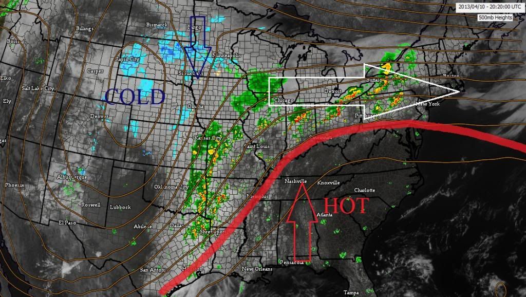
There's a stalled boundary draped from Ohio to CT.
#1. Clouds from this keeping temps down.
#2. Warm air cannot push north of there and so it stops
Look at the 500mb heights pattern you'll see exactly whats happening
Remember, Ridge = Hot. Trough = Cold. But look at the top of the ridge, the flow is cut off and is West-East flowing. Notice the clouds too. All sun where its hitting 80s/90s.
Upper level low in Canada (not in picture here) keeping the ridge south
Yeah Cambium, I can believe that. I live in the Harrisburg region and it's been a scorcher today, though nto quite as bad as Baltimore (B'more as we call it here). Right outside my window I can see cumulonimbus clouds building up in the sky whereas it was sunny earlier today
Please register to post and access all features of our very popular forum. It is free and quick. Over $68,000 in prizes has already been given out to active posters on our forum. Additional giveaways are planned.
Detailed information about all U.S. cities, counties, and zip codes on our site: City-data.com.

 Please register to participate in our discussions with 2 million other members - it's free and quick! Some forums can only be seen by registered members. After you create your account, you'll be able to customize options and access all our 15,000 new posts/day with fewer ads.