Stratham, New Hampshire
Submit your own pictures of this town and show them to the world
- OSM Map
- General Map
- Google Map
- MSN Map
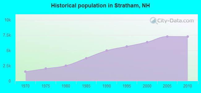
Population change since 2000: +14.2%
 |
| Males: 3,534 | |
| Females: 3,721 |
| Median resident age: | 43.3 years |
| New Hampshire median age: | 43.9 years |
Zip codes: 03885.
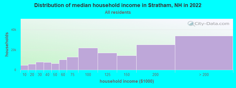
| Stratham: | $141,764 |
| NH: | $89,992 |
Estimated per capita income in 2022: $73,031 (it was $33,270 in 2000)
Stratham town income, earnings, and wages data
Estimated median house or condo value in 2022: $601,646 (it was $196,900 in 2000)
| Stratham: | $601,646 |
| NH: | $384,700 |
Mean prices in 2022: all housing units: $614,227; detached houses: $665,470; townhouses or other attached units: $408,866; in 2-unit structures: $730,084; in 3-to-4-unit structures: over $1,000,000; in 5-or-more-unit structures: $329,099; mobile homes: $126,160
Detailed information about poverty and poor residents in Stratham, NH


- 6,91795.3%White alone
- 1381.9%Asian alone
- 951.3%Hispanic
- 831.1%Two or more races
- 100.1%Black alone
- 60.08%American Indian alone
- 40.06%Native Hawaiian and Other
Pacific Islander alone - 20.03%Other race alone
Races in Stratham detailed stats: ancestries, foreign born residents, place of birth
Type |
2009 |
2010 |
2011 |
2012 |
2013 |
2014 |
2015 |
2016 |
2017 |
2018 |
2019 |
2020 |
2021 |
2022 |
|---|---|---|---|---|---|---|---|---|---|---|---|---|---|---|
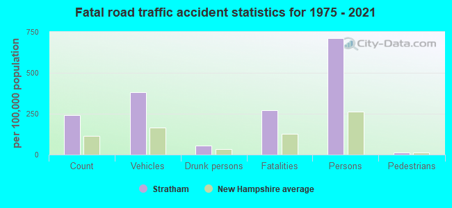
| Murders (per 100,000) | 0 (0.0) | 0 (0.0) | 0 (0.0) | 0 (0.0) | 0 (0.0) | 0 (0.0) | 0 (0.0) | 0 (0.0) | 0 (0.0) | 0 (0.0) | 0 (0.0) | 1 (13.3) | 0 (0.0) | 0 (0.0) |
| Rapes (per 100,000) | 0 (0.0) | 0 (0.0) | 1 (13.8) | 1 (13.7) | 1 (13.6) | 3 (40.7) | 0 (0.0) | 1 (13.5) | 1 (13.4) | 1 (13.4) | 0 (0.0) | 0 (0.0) | 0 (0.0) | 0 (0.0) |
| Robberies (per 100,000) | 0 (0.0) | 2 (27.6) | 0 (0.0) | 0 (0.0) | 0 (0.0) | 0 (0.0) | 0 (0.0) | 1 (13.5) | 0 (0.0) | 1 (13.4) | 0 (0.0) | 0 (0.0) | 0 (0.0) | 0 (0.0) |
| Assaults (per 100,000) | 1 (13.5) | 1 (13.8) | 3 (41.3) | 3 (41.1) | 1 (13.6) | 1 (13.6) | 0 (0.0) | 2 (27.0) | 2 (26.8) | 3 (40.1) | 2 (26.7) | 2 (26.6) | 1 (13.0) | 1 (12.7) |
| Burglaries (per 100,000) | 5 (67.6) | 8 (110.3) | 11 (151.4) | 8 (109.7) | 3 (40.9) | 10 (135.7) | 9 (121.6) | 5 (67.5) | 7 (93.9) | 4 (53.4) | 1 (13.4) | 2 (26.6) | 1 (13.0) | 1 (12.7) |
| Thefts (per 100,000) | 45 (608.6) | 66 (909.7) | 61 (839.6) | 72 (987.2) | 57 (776.9) | 51 (692.3) | 28 (378.4) | 40 (540.3) | 33 (442.8) | 29 (387.5) | 41 (548.2) | 25 (332.4) | 21 (272.5) | 16 (204.0) |
| Auto thefts (per 100,000) | 1 (13.5) | 2 (27.6) | 1 (13.8) | 2 (27.4) | 0 (0.0) | 3 (40.7) | 3 (40.5) | 0 (0.0) | 0 (0.0) | 2 (26.7) | 2 (26.7) | 0 (0.0) | 1 (13.0) | 1 (12.7) |
| Arson (per 100,000) | 0 (0.0) | 1 (13.8) | 0 (0.0) | 2 (27.4) | 0 (0.0) | 0 (0.0) | 1 (13.5) | 0 (0.0) | 1 (13.4) | 0 (0.0) | 0 (0.0) | 1 (13.3) | 1 (13.0) | 0 (0.0) |
| City-Data.com crime index | 32.9 | 57.3 | 64.6 | 68.6 | 47.6 | 75.7 | 26.9 | 46.6 | 40.4 | 44.1 | 30.4 | 47.1 | 15.4 | 12.6 |
The City-Data.com crime index weighs serious crimes and violent crimes more heavily. Higher means more crime, U.S. average is 246.1. It adjusts for the number of visitors and daily workers commuting into cities.
Crime rate in Stratham detailed stats: murders, rapes, robberies, assaults, burglaries, thefts, arson
Full-time law enforcement employees in 2021, including police officers: 12 (11 officers - 10 male; 1 female).
| Officers per 1,000 residents here: | 1.43 |
| New Hampshire average: | 2.14 |
 Recent articles from our blog. Our writers, many of them Ph.D. graduates or candidates, create easy-to-read articles on a wide variety of topics.


 | Move to NH - Suggested Areas & Towns? (108 replies) |
| Best safe towns for commute to Portsmouth NH (34 replies) |
| Seacoast- In Depth (26 replies) |
| Relo to Stratham from the Dallas... (10 replies) |
| Airplane Traffic and Noise - Seacoast, Dover and Exeter Areas (23 replies) |
| Best towns in NH for 40+ singles (8 replies) |
Latest news from Stratham, NH collected exclusively by city-data.com from local newspapers, TV, and radio stations
Ancestries: Irish (27.8%), English (22.5%), German (12.6%), Italian (11.2%), French (9.5%), Polish (7.1%).
Current Local Time: EST time zone
Incorporated in 1716
Elevation: 58 feet
Land area: 15.1 square miles.
Population density: 480 people per square mile (low).
192 residents are foreign born (1.7% Europe, 0.7% Asia, 0.4% North America).
| This town: | 3.0% |
| New Hampshire: | 4.4% |
| Stratham town: | 1.8% ($3,635) |
| New Hampshire: | 2.3% ($2,946) |
Nearest city with pop. 50,000+: Haverhill, MA  (18.9 miles , pop. 58,969).
Nearest city with pop. 200,000+: Boston, MA (48.9 miles , pop. 589,141).
Nearest city with pop. 1,000,000+: Bronx, NY (214.2 miles , pop. 1,332,650).
Nearest cities:
), ), ), )Latitude: 43.02 N, Longitude: 70.90 W
Area code commonly used in this area: 603

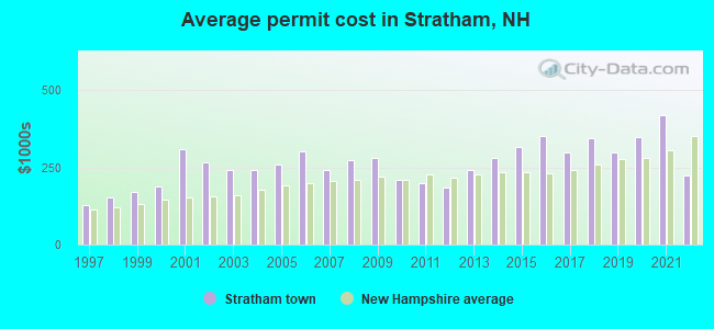
Single-family new house construction building permits:
- 2022: 2 buildings, average cost: $224,900
- 2021: 10 buildings, average cost: $419,300
- 2020: 27 buildings, average cost: $346,500
- 2019: 52 buildings, average cost: $297,900
- 2018: 26 buildings, average cost: $345,900
- 2017: 18 buildings, average cost: $299,400
- 2016: 12 buildings, average cost: $353,300
- 2015: 14 buildings, average cost: $315,000
- 2014: 17 buildings, average cost: $278,600
- 2013: 18 buildings, average cost: $242,200
- 2012: 7 buildings, average cost: $185,700
- 2011: 14 buildings, average cost: $199,000
- 2010: 4 buildings, average cost: $210,000
- 2009: 8 buildings, average cost: $279,200
- 2008: 16 buildings, average cost: $271,800
- 2007: 45 buildings, average cost: $241,500
- 2006: 33 buildings, average cost: $300,600
- 2005: 52 buildings, average cost: $257,900
- 2004: 90 buildings, average cost: $240,200
- 2003: 76 buildings, average cost: $242,400
- 2002: 56 buildings, average cost: $268,300
- 2001: 33 buildings, average cost: $310,100
- 2000: 52 buildings, average cost: $188,300
- 1999: 65 buildings, average cost: $168,600
- 1998: 46 buildings, average cost: $150,900
- 1997: 40 buildings, average cost: $129,100

| Here: | 2.1% |
| New Hampshire: | 2.5% |
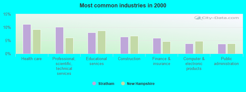
- Health care (11.2%)
- Professional, scientific, technical services (10.1%)
- Educational services (8.0%)
- Construction (6.3%)
- Finance & insurance (5.9%)
- Computer & electronic products (3.8%)
- Public administration (3.8%)
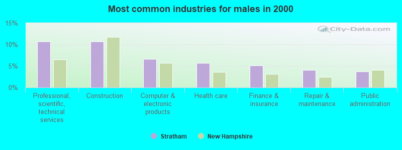
- Professional, scientific, technical services (10.7%)
- Construction (10.7%)
- Computer & electronic products (6.6%)
- Health care (5.7%)
- Finance & insurance (5.2%)
- Repair & maintenance (4.1%)
- Public administration (3.7%)

- Health care (17.7%)
- Educational services (14.8%)
- Professional, scientific, technical services (9.3%)
- Finance & insurance (6.8%)
- Public administration (3.8%)
- Data processing, libraries, other information services (3.0%)
- Accommodation & food services (2.6%)
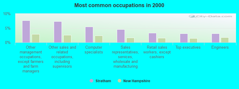
- Other management occupations, except farmers and farm managers (7.6%)
- Other sales and related occupations, including supervisors (7.4%)
- Computer specialists (5.5%)
- Sales representatives, services, wholesale and manufacturing (4.6%)
- Retail sales workers, except cashiers (3.3%)
- Top executives (3.1%)
- Engineers (3.1%)
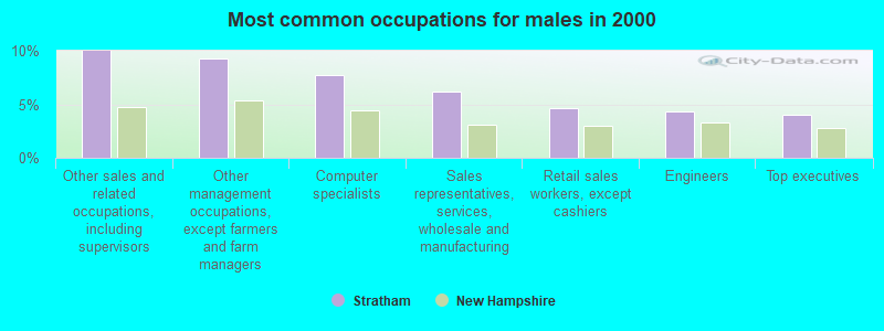
- Other sales and related occupations, including supervisors (10.0%)
- Other management occupations, except farmers and farm managers (9.3%)
- Computer specialists (7.7%)
- Sales representatives, services, wholesale and manufacturing (6.1%)
- Retail sales workers, except cashiers (4.6%)
- Engineers (4.3%)
- Top executives (4.1%)
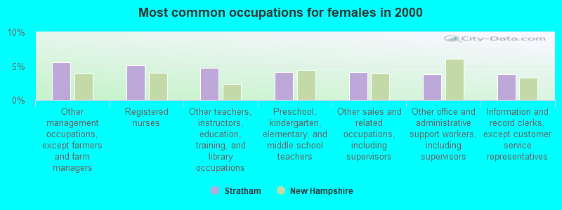
- Other management occupations, except farmers and farm managers (5.6%)
- Registered nurses (5.2%)
- Other teachers, instructors, education, training, and library occupations (4.8%)
- Preschool, kindergarten, elementary, and middle school teachers (4.2%)
- Other sales and related occupations, including supervisors (4.2%)
- Other office and administrative support workers, including supervisors (3.8%)
- Information and record clerks, except customer service representatives (3.8%)
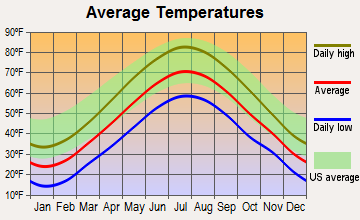
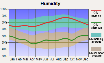
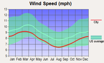
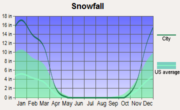
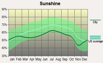
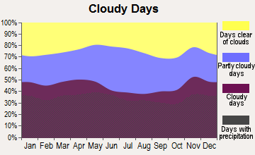
Average climate in Stratham, New Hampshire
Based on data reported by over 4,000 weather stations
(lower is better)
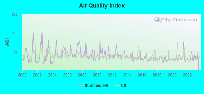
Air Quality Index (AQI) level in 2022 was 64.4. This is about average.
| City: | 64.4 |
| U.S.: | 72.6 |
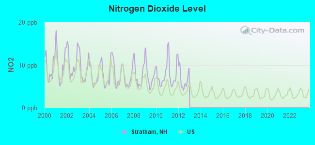
Nitrogen Dioxide (NO2) [ppb] level in 2012 was 6.65. This is worse than average. Closest monitor was 7.4 miles away from the city center.
| City: | 6.65 |
| U.S.: | 5.11 |
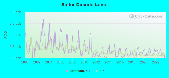
Sulfur Dioxide (SO2) [ppb] level in 2022 was 1.48. This is about average. Closest monitor was 7.4 miles away from the city center.
| City: | 1.48 |
| U.S.: | 1.51 |
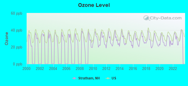
Ozone [ppb] level in 2022 was 29.6. This is about average. Closest monitor was 8.0 miles away from the city center.
| City: | 29.6 |
| U.S.: | 33.3 |
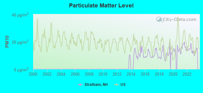
Particulate Matter (PM10) [µg/m3] level in 2022 was 14.4. This is better than average. Closest monitor was 8.3 miles away from the city center.
| City: | 14.4 |
| U.S.: | 19.2 |
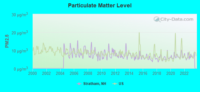
Particulate Matter (PM2.5) [µg/m3] level in 2022 was 6.49. This is better than average. Closest monitor was 8.3 miles away from the city center.
| City: | 6.49 |
| U.S.: | 8.11 |
Tornado activity:
Stratham-area historical tornado activity is near New Hampshire state average. It is 53% smaller than the overall U.S. average.
On 6/9/1953, a category F3 (max. wind speeds 158-206 mph) tornado 4.7 miles away from the Stratham town center injured 5 people and caused between $5000 and $50,000 in damages.
On 9/29/1974, a category F3 tornado 31.3 miles away from the town center injured one person and caused between $50,000 and $500,000 in damages.
Earthquake activity:
Stratham-area historical earthquake activity is significantly above New Hampshire state average. It is 73% smaller than the overall U.S. average.On 10/16/2012 at 23:12:25, a magnitude 4.7 (4.7 ML, Depth: 10.0 mi, Class: Light, Intensity: IV - V) earthquake occurred 42.1 miles away from Stratham center
On 4/20/2002 at 10:50:47, a magnitude 5.3 (5.3 ML, Depth: 3.0 mi, Class: Moderate, Intensity: VI - VII) earthquake occurred 173.8 miles away from the city center
On 1/19/1982 at 00:14:42, a magnitude 4.7 (4.5 MB, 4.7 MD, 4.5 LG) earthquake occurred 48.6 miles away from the city center
On 10/7/1983 at 10:18:46, a magnitude 5.3 (5.1 MB, 5.3 LG, 5.1 ML) earthquake occurred 184.4 miles away from the city center
On 4/20/2002 at 10:50:47, a magnitude 5.2 (5.2 MB, 4.2 MS, 5.2 MW, 5.0 MW) earthquake occurred 173.6 miles away from the city center
On 8/22/1992 at 12:20:32, a magnitude 4.8 (4.8 MB, 3.8 MS, 4.7 LG, Depth: 6.2 mi) earthquake occurred 272.1 miles away from the city center
Magnitude types: regional Lg-wave magnitude (LG), body-wave magnitude (MB), duration magnitude (MD), local magnitude (ML), surface-wave magnitude (MS), moment magnitude (MW)
Natural disasters:
The number of natural disasters in Rockingham County (26) is a lot greater than the US average (15).Major Disasters (Presidential) Declared: 17
Emergencies Declared: 9
Causes of natural disasters: Storms: 12, Floods: 9, Winter Storms: 5, Hurricanes: 4, Snowstorms: 4, Snows: 2, Winds: 2, Blizzard: 1, Snowfall: 1, Tornado: 1 (Note: some incidents may be assigned to more than one category).
Main business address for: TIMBERLAND CO (FOOTWEAR, (NO RUBBER)).
Hospitals and medical centers near Stratham:
- EXETER HOSPITAL INC Acute Care Hospitals (about 3 miles away; EXETER, NH)
- EXETER HEALTHCARE (Nursing Home, about 3 miles away; EXETER, NH)
- FMC DIALYSIS SERVICES OF EXETER (Dialysis Facility, about 3 miles away; EXETER, NH)
- SEACOAST HOSPICE (Hospital, about 3 miles away; EXETER, NH)
- EVENTIDE HOME INC (Nursing Home, about 4 miles away; EXETER, NH)
- EXETER ON HAMPTON CARE AND REHABILITATION CENTER (Nursing Home, about 4 miles away; EXETER, NH)
- ROCKINGHAM VNA AND HOSPICE (Home Health Center, about 4 miles away; EXETER, NH)
Operable nuclear power plant near Stratham:
- 10 miles: Seabrook in Seabrook, NH.
Colleges/universities with over 2000 students nearest to Stratham:
- University of New Hampshire-Main Campus (about 9 miles; Durham, NH; Full-time enrollment: 15,243)
- Northern Essex Community College (about 17 miles; Haverhill, MA; FT enrollment: 4,737)
- Merrimack College (about 27 miles; North Andover, MA; FT enrollment: 2,734)
- Southern New Hampshire University (about 28 miles; Manchester, NH; FT enrollment: 16,552)
- Mount Washington College (about 29 miles; Manchester, NH; FT enrollment: 2,187)
- North Shore Community College (about 30 miles; Danvers, MA; FT enrollment: 5,195)
- Saint Anselm College (about 31 miles; Manchester, NH; FT enrollment: 2,059)
Public elementary/middle schools in Stratham:
- COOPERATIVE MIDDLE SCHOOL (Students: 1,326, Location: 100 ACADEMIC WAY, Grades: 6-8)
- STRATHAM MEMORIAL SCHOOL (Students: 621, Location: 39 GIFFORD FARM RD., Grades: PK-5)
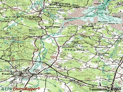
Points of interest:
Notable locations in Stratham: Stratham Fairgrounds (A), Stratham Industrial Park (B), Stratham Volunteer Fire Department (C), Wiggin Memorial Library (D), Stratham Town Hall (E), Stratham Municipal Center (F), New Hampshire Technical College Learning Resources Center (G). Display/hide their locations on the map
Main business address in Stratham: TIMBERLAND CO (A). Display/hide its location on the map
Churches in Stratham include: Cornerstone Baptist Church (A), Stratham Church (B). Display/hide their locations on the map
Cemetery: Greenwood Cemetery (1). Display/hide its location on the map
Reservoir: Winnicut Mills Pond (A). Display/hide its location on the map
Streams, rivers, and creeks: Parting Brook (A), Mill Brook (B), Jewell Hill Brook (C). Display/hide their locations on the map
Tourist attraction: Stratham Historical Society (Cultural Attractions- Events- & Facilities; Portsmouth Avenue).
Drinking water stations with addresses in Stratham and their reported violations in the past:
AMBLESIDE MHP (Population served: 163, Groundwater):Past health violations:PENINSULA AT WINDING BROOK (Population served: 128, Groundwater):
- MCL, Monthly (TCR) - In APR-2005, Contaminant: Coliform. Follow-up actions: St Public Notif requested (APR-22-2005), St Violation/Reminder Notice (APR-22-2005), St Public Notif received (MAY-09-2005), St Compliance achieved (DEC-05-2005)
Past health violations:SWEET DREAMS BAKERY (Population served: 100, Groundwater):Past monitoring violations:
- MCL, Monthly (TCR) - In NOV-2005, Contaminant: Coliform. Follow-up actions: St Public Notif requested (DEC-08-2005), St Violation/Reminder Notice (DEC-08-2005), St Public Notif received (JAN-04-2006), St Compliance achieved (JUN-30-2006)
- MCL, Monthly (TCR) - In OCT-2005, Contaminant: Coliform. Follow-up actions: St Public Notif requested (NOV-01-2005), St Violation/Reminder Notice (NOV-01-2005), St Formal NOV issued (NOV-02-2005), St Public Notif received (NOV-07-2005), St Compliance achieved (JUN-30-2006)
- MCL, Monthly (TCR) - In SEP-2005, Contaminant: Coliform. Follow-up actions: St Public Notif requested (OCT-19-2005), St Violation/Reminder Notice (OCT-19-2005), St Formal NOV issued (NOV-02-2005), St Public Notif received (NOV-07-2005), St Compliance achieved (JUN-30-2006)
- Lead Consumer Notice - In JUL-01-2012, Contaminant: Lead and Copper Rule. Follow-up actions: St Violation/Reminder Notice (JUL-10-2012), St Compliance achieved (JUL-18-2012)
- One routine major monitoring violation
- One regular monitoring violation
Past health violations:MUIRFIELD CLUSTER (Population served: 69, Groundwater):Past monitoring violations:
- MCL, Monthly (TCR) - Between JUL-2009 and SEP-2009, Contaminant: Coliform. Follow-up actions: St Violation/Reminder Notice (SEP-30-2009), St Public Notif requested (SEP-30-2009), St Public Notif received (OCT-20-2009), St Compliance achieved (SEP-29-2010)
- 13 routine major monitoring violations
Past health violations:JEWETT HILL (Population served: 50, Groundwater):
- MCL, Average - Between JUL-2013 and SEP-2013, Contaminant: Arsenic. Follow-up actions: St Public Notif requested (OCT-07-2013), St Violation/Reminder Notice (OCT-07-2013), St Public Notif received (OCT-31-2013)
- MCL, Average - Between JAN-2013 and MAR-2013, Contaminant: Arsenic. Follow-up actions: St Public Notif requested (APR-16-2013), St Violation/Reminder Notice (APR-16-2013), St Public Notif received (APR-22-2013), St Formal NOV issued (MAY-10-2013)
- MCL, Average - Between OCT-2012 and DEC-2012, Contaminant: Arsenic. Follow-up actions: St Public Notif requested (JAN-14-2013), St Violation/Reminder Notice (JAN-14-2013), St Public Notif received (JAN-29-2013), St Formal NOV issued (MAY-10-2013)
- MCL, Average - Between JUL-2010 and SEP-2010, Contaminant: Antimony, Total. Follow-up actions: St AO (w/o penalty) issued (JUL-08-2009), St Public Notif requested (SEP-09-2010), St Violation/Reminder Notice (SEP-09-2010), St Public Notif received (SEP-17-2010), St Compliance achieved (AUG-02-2011)
- MCL, Average - Between APR-2010 and JUN-2010, Contaminant: Antimony, Total. Follow-up actions: St AO (w/o penalty) issued (JUL-08-2009), St Public Notif requested (JUL-08-2010), St Violation/Reminder Notice (JUL-08-2010), St Public Notif received (JUL-21-2010), St Compliance achieved (AUG-02-2011)
- MCL, Average - Between JAN-2010 and MAR-2010, Contaminant: Antimony, Total. Follow-up actions: St AO (w/o penalty) issued (JUL-08-2009), St Public Notif requested (APR-30-2010), St Violation/Reminder Notice (APR-30-2010), St Public Notif received (MAY-11-2010), St Compliance achieved (AUG-02-2011)
- 12 other older health violations
Past health violations:ABERDEEN/WEST (Population served: 46, Groundwater):Past monitoring violations:
- MCL, Monthly (TCR) - In OCT-2007, Contaminant: Coliform. Follow-up actions: St Public Notif requested (OCT-23-2007), St Violation/Reminder Notice (OCT-23-2007), St Public Notif received (NOV-01-2007), St Compliance achieved (MAY-29-2008)
- MCL, Monthly (TCR) - In SEP-2007, Contaminant: Coliform. Follow-up actions: St Public Notif requested (OCT-03-2007), St Violation/Reminder Notice (OCT-03-2007), St Formal NOV issued (OCT-19-2007), St Public Notif received (NOV-02-2007), St Compliance achieved (MAY-29-2008)
- MCL, Acute (TCR) - In JUL-2007, Contaminant: Coliform. Follow-up actions: St Public Notif requested (JUL-25-2007), St Violation/Reminder Notice (JUL-25-2007), St Public Notif received (SEP-04-2007), St Formal NOV issued (OCT-19-2007), St Compliance achieved (MAY-29-2008)
- Failure To Address Deficiency - In AUG-18-2012, Contaminant: GROUNDWATER RULE. Follow-up actions: St Public Notif requested (SEP-05-2012), St Formal NOV issued (SEP-05-2012), St Compliance achieved (OCT-30-2012), St Public Notif received (OCT-30-2012)
Past health violations:LAMINGTON HILL (Population served: 35, Groundwater):
- MCL, Average - Between JUL-2009 and SEP-2009, Contaminant: Arsenic. Follow-up actions: St Public Notif requested (NOV-06-2009), St Violation/Reminder Notice (NOV-06-2009), St Public Notif received (NOV-16-2009), St Compliance achieved (FEB-22-2010)
- MCL, Average - Between APR-2009 and JUN-2009, Contaminant: Arsenic. Follow-up actions: St Violation/Reminder Notice (JUL-22-2009), St Public Notif requested (JUL-22-2009), St Public Notif received (OCT-08-2009), St Formal NOV issued (OCT-27-2009), St BCA signed (NOV-02-2009), St Compliance achieved (FEB-22-2010)
- MCL, Average - Between JAN-2008 and MAR-2008, Contaminant: Arsenic. Follow-up actions: St Public Notif requested (APR-10-2008), St Violation/Reminder Notice (APR-10-2008), St Public Notif received (MAY-07-2008), St Compliance achieved (APR-21-2009)
Past health violations:STRATHAM MUNICIPAL CENTER (Address: 10 BUNKER HILL AVE , Population served: 25, Groundwater):Past monitoring violations:
- MCL, Average - Between APR-2009 and JUN-2009, Contaminant: Arsenic. Follow-up actions: St AO (w/o penalty) issued (JUL-14-2008), St Public Notif requested (JUL-22-2009), St Violation/Reminder Notice (JUL-22-2009), St Public Notif received (AUG-14-2009), St Compliance achieved (APR-15-2010)
- MCL, Average - Between JAN-2009 and MAR-2009, Contaminant: Arsenic. Follow-up actions: St AO (w/o penalty) issued (JUL-14-2008), St Public Notif requested (APR-14-2009), St Violation/Reminder Notice (APR-14-2009), St Public Notif received (APR-30-2009), St Compliance achieved (APR-15-2010)
- MCL, Average - Between OCT-2008 and DEC-2008, Contaminant: Arsenic. Follow-up actions: St AO (w/o penalty) issued (JUL-14-2008), St Violation/Reminder Notice (JAN-30-2009), St Public Notif requested (JAN-30-2009), St Formal NOV issued (MAY-11-2009), St Public Notif received (MAY-18-2009), St Compliance achieved (APR-15-2010)
- MCL, Average - Between JUL-2008 and SEP-2008, Contaminant: Arsenic. Follow-up actions: St AO (w/o penalty) issued (JUL-14-2008), St Public Notif requested (OCT-31-2008), St Violation/Reminder Notice (OCT-31-2008), St Public Notif received (NOV-13-2008), St Compliance achieved (APR-15-2010)
- MCL, Average - Between APR-2008 and JUN-2008, Contaminant: Arsenic. Follow-up actions: St Public Notif requested (JUL-08-2008), St Violation/Reminder Notice (JUL-08-2008), St AO (w/o penalty) issued (JUL-14-2008), St Public Notif received (JUL-21-2008), St Compliance achieved (APR-15-2010)
- MCL, Average - Between JAN-2008 and MAR-2008, Contaminant: Arsenic. Follow-up actions: St Public Notif requested (MAR-17-2008), St Violation/Reminder Notice (MAR-17-2008), St Public Notif received (MAR-26-2008), St AO (w/o penalty) issued (JUL-14-2008), St Compliance achieved (APR-15-2010)
- 4 other older health violations
- Failure To Address Deficiency - In JAN-09-2014, Contaminant: GROUNDWATER RULE. Follow-up actions: St Public Notif requested (JAN-24-2014), St Formal NOV issued (JAN-24-2014), St Compliance achieved (JAN-30-2014), St Public Notif received (MAR-19-2014)
Past monitoring violations:
- 2 regular monitoring violations
Drinking water stations with addresses in Stratham that have no violations reported:
| This town: | 2.6 people |
| New Hampshire: | 2.5 people |
| This town: | 74.5% |
| Whole state: | 66.3% |
| This town: | 5.4% |
| Whole state: | 8.3% |
Likely homosexual households (counted as self-reported same-sex unmarried-partner households)
- Lesbian couples: 0.5% of all households
- Gay men: 0.2% of all households
| This town: | 1.2% |
| Whole state: | 6.5% |
| This town: | 0.3% |
| Whole state: | 2.8% |
Banks with branches in Stratham (2011 data):
- RBS Citizens, National Association: Stratham Branch at 38 Portsmouth Avenue, branch established on 1975/01/08; Stratham Shaw's Branch at 100 Shaw's Lane, branch established on 1995/07/10. Info updated 2007/09/19: Bank assets: $106,940.6 mil, Deposits: $75,690.2 mil, headquarters in Providence, RI, positive income, 1135 total offices, Holding Company: Uk Financial Investments Limited
- TD Bank, National Association: Stratham Branch at 28 Portsmouth Avenue, King's Highway, branch established on 1995/12/18. Info updated 2010/10/04: Bank assets: $188,912.6 mil, Deposits: $153,149.8 mil, headquarters in Wilmington, DE, positive income, 1314 total offices, Holding Company: Toronto-Dominion Bank, The
- Optima Bank & Trust Company: Stratham Branch at 17 Portsmouth Avenue, branch established on 2011/07/18. Info updated 2012/01/25: Bank assets: $193.5 mil, Deposits: $171.7 mil, headquarters in Portsmouth, NH, positive income, Commercial Lending Specialization, 3 total offices
- People's United Bank: Stratham-101&Winnicut Branch at 160 Portsmouth Avenue, branch established on 1892/01/01. Info updated 2012/02/16: Bank assets: $27,319.3 mil, Deposits: $20,835.4 mil, headquarters in Bridgeport, CT, positive income, Commercial Lending Specialization, 374 total offices
For population 15 years and over in Stratham:
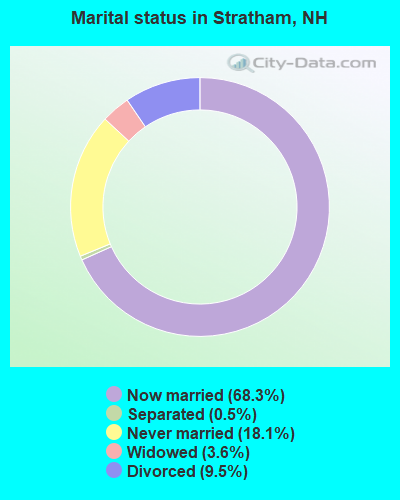
- Never married: 18.1%
- Now married: 68.3%
- Separated: 0.5%
- Widowed: 3.6%
- Divorced: 9.5%
For population 25 years and over in Stratham:
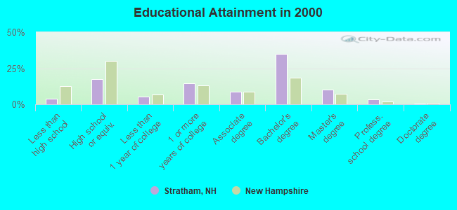
- High school or higher: 96.1%
- Bachelor's degree or higher: 49.6%
- Graduate or professional degree: 14.5%
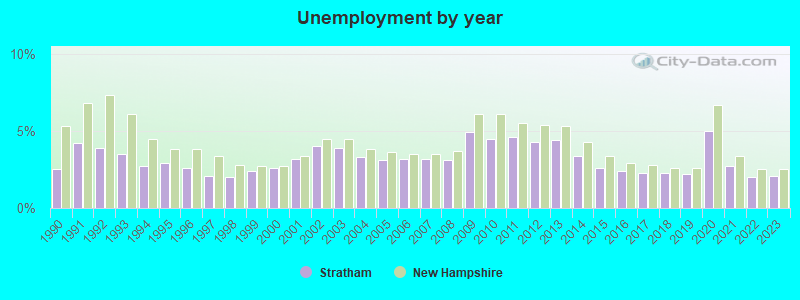
- Unemployed: 2.9%
- Mean travel time to work (commute): 27.2 minutes
| Here: | 8.6 |
| New Hampshire average: | 10.9 |


Graphs represent county-level data. Detailed 2008 Election Results
Religion statistics for Stratham, NH (based on Rockingham County data)


| Religion | Adherents | Congregations |
|---|---|---|
| Catholic | 84,697 | 24 |
| Mainline Protestant | 19,072 | 78 |
| Evangelical Protestant | 7,456 | 61 |
| Other | 3,490 | 20 |
| Orthodox | 200 | 1 |
| None | 180,308 | - |
Food Environment Statistics:
| This county: | 1.59 / 10,000 pop. |
| New Hampshire: | 2.14 / 10,000 pop. |
| Rockingham County: | 0.17 / 10,000 pop. |
| New Hampshire: | 0.15 / 10,000 pop. |
| This county: | 1.86 / 10,000 pop. |
| New Hampshire: | 1.78 / 10,000 pop. |
| Rockingham County: | 3.31 / 10,000 pop. |
| New Hampshire: | 4.02 / 10,000 pop. |
| This county: | 9.56 / 10,000 pop. |
| New Hampshire: | 9.70 / 10,000 pop. |
| Rockingham County: | 7.6% |
| New Hampshire: | 7.6% |
| This county: | 23.3% |
| State: | 24.4% |
| Rockingham County: | 16.8% |
| New Hampshire: | 15.9% |
7.69% of this county's 2021 resident taxpayers lived in other counties in 2020 ($114,534 average adjusted gross income)
| Here: | 7.69% |
| New Hampshire average: | 7.66% |
0.01% of residents moved from foreign countries ($203 average AGI)
Rockingham County: 0.01% New Hampshire average: 0.01%
Top counties from which taxpayers relocated into this county between 2020 and 2021:
| from Essex County, MA | |
| from Hillsborough County, NH | |
| from Middlesex County, MA |
6.82% of this county's 2020 resident taxpayers moved to other counties in 2021 ($88,778 average adjusted gross income)
| Here: | 6.82% |
| New Hampshire average: | 6.80% |
0.01% of residents moved to foreign countries ($126 average AGI)
Rockingham County: 0.01% New Hampshire average: 0.01%
Top counties to which taxpayers relocated from this county between 2020 and 2021:
| to Hillsborough County, NH | |
| to Strafford County, NH | |
| to Essex County, MA |
| Businesses in Stratham, NH | ||||
| Name | Count | Name | Count | |
|---|---|---|---|---|
| Audi | 1 | Jones New York | 1 | |
| AutoZone | 1 | Lane Furniture | 2 | |
| BMW | 1 | MasterBrand Cabinets | 4 | |
| Blockbuster | 1 | Nissan | 1 | |
| Burger King | 1 | RadioShack | 1 | |
| CVS | 1 | Rite Aid | 1 | |
| Circle K | 1 | Shaw's | 1 | |
| Curves | 1 | Staples | 1 | |
| Decora Cabinetry | 2 | Subaru | 1 | |
| Domino's Pizza | 1 | Subway | 1 | |
| Dunkin Donuts | 3 | T-Mobile | 1 | |
| Fashion Bug | 1 | Talbots | 1 | |
| FedEx | 3 | UPS | 3 | |
| GNC | 1 | Vans | 1 | |
| Honda | 1 | |||
Strongest AM radio stations in Stratham:
- WGIP (1540 AM; 5 kW; EXETER, NH; Owner: CAPSTAR TX LIMITED PARTNERSHIP)
- WRKO (680 AM; 50 kW; BOSTON, MA; Owner: ENTERCOM BOSTON LICENSE, LLC)
- WGIN (930 AM; 10 kW; ROCHESTER, NH; Owner: CAPSTAR TX LIMITED PARTNERSHIP)
- WTSN (1270 AM; 5 kW; DOVER, NH; Owner: GARRISON CITY BROADCASTING, INC.)
- WEEI (850 AM; 50 kW; BOSTON, MA; Owner: ENTERCOM BOSTON LICENSE, LLC)
- WBZ (1030 AM; 50 kW; BOSTON, MA; Owner: INFINITY BROADCASTING OPERATIONS, INC.)
- WMYF (1380 AM; 1 kW; PORTSMOUTH, NH; Owner: CAPSTAR TX LIMITED PARTNERSHIP)
- WWZN (1510 AM; 50 kW; BOSTON, MA; Owner: ROSE CITY RADIO CORPORATION)
- WDER (1320 AM; 10 kW; DERRY, NH; Owner: BLOUNT COMMUNICATIONS, INC. OF NH)
- WKOX (1200 AM; 50 kW; FRAMINGHAM, MA; Owner: CAPSTAR TX LIMITED PARTNERSHIP)
- WBIX (1060 AM; 40 kW; NATICK, MA; Owner: LANGER BROADCASTING CORPORATION)
- WCRN (830 AM; 50 kW; WORCESTER, MA; Owner: CARTER BROADCASTING CORPORATION)
- WGIR (610 AM; 5 kW; MANCHESTER, NH; Owner: CAPSTAR TX LIMITED PARTNERSHIP)
Strongest FM radio stations in Stratham:
- WERZ (107.1 FM; EXETER, NH; Owner: CAPSTAR TX LIMITED PARTNERSHIP)
- WHEB (100.3 FM; PORTSMOUTH, NH; Owner: CAPSTAR TX LIMITED PARTNERSHIP)
- WSAK (102.1 FM; HAMPTON, NH; Owner: CITADEL BROADCASTING COMPANY)
- WNEF (91.7 FM; NEWBURYPORT, MA; Owner: UNIVERSITY OF MASSACHUSETTS)
- WUBB (95.3 FM; YORK CENTER, ME; Owner: CAPSTAR TX LIMITED PARTNERSHIP)
- WOKQ (97.5 FM; DOVER, NH; Owner: CITADEL BROADCASTING COMPANY)
- WXRV (92.5 FM; HAVERHILL, MA; Owner: BEANPOT BROADCASTING CORP.)
- WSHK (105.3 FM; KITTERY, ME; Owner: CITADEL BROADCASTING COMPANY)
- WUNH (91.3 FM; DURHAM, NH; Owner: UNIVERSITY OF NEW HAMPSHIRE)
- WSCY (106.9 FM; MOULTONBOROUGH, NH; Owner: NORTHEAST COMMUNICATIONS CORPORATION)
- WGIR-FM (101.1 FM; MANCHESTER, NH; Owner: CAPSTAR TX LIMITED PARTNERSHIP)
- WQLL (96.5 FM; BEDFORD, NH; Owner: SAGA COMMUNICATIONS OF NEW ENGLAND, LLC)
- WLMW (90.7 FM; MANCHESTER, NH; Owner: KNOWLEDGE FOR LIFE)
- WBYY (98.7 FM; SOMERSWORTH, NH; Owner: GARRISON CITY BROADCASTING, INC.)
- WMEA (90.1 FM; PORTLAND, ME; Owner: MAINE PUBLIC BROADCASTING CORPORATION)
- WMEX (106.5 FM; FARMINGTON, NH; Owner: WIMMEX, LLC)
- WZID (95.7 FM; MANCHESTER, NH; Owner: SAGA COMMUNICATIONS OF NEW ENGLAND, LLC)
- WFEX (92.1 FM; PETERBOROUGH, NH; Owner: FNX BROADCASTING OF NEW HAMPSHIRE LLC)
- WKLB-FM (99.5 FM; LOWELL, MA; Owner: GREATER BOSTON RADIO, INC.)
- WPHX-FM (92.1 FM; SANFORD, ME; Owner: FNX BROADCASTING LLC)
TV broadcast stations around Stratham:
- WHDN-LP (Channel 26; BOSTON, MA; Owner: GUENTER MARKSTEINER)
- WMEA-TV (Channel 26; BIDDEFORD, ME; Owner: MAINE PUBLIC BROADCASTING CORP.)
- WFXZ-CA (Channel 24; BOSTON, MA; Owner: BOSTON BROADCASTING CORP.)
- WENH-TV (Channel 11; DURHAM, NH; Owner: UNIVERSITY OF NEW HAMPSHIRE)
- National Bridge Inventory (NBI) Statistics
- 5Number of bridges
- 52ft / 16.1mTotal length
- $9,426,000Total costs
- 82,610Total average daily traffic
- 5,736Total average daily truck traffic
FCC Registered Commercial Land Mobile Towers:
2 (See the full list of FCC Registered Commercial Land Mobile Towers in Stratham, NH)FCC Registered Private Land Mobile Towers:
1 (See the full list of FCC Registered Private Land Mobile Towers)FCC Registered Broadcast Land Mobile Towers:
7 (See the full list of FCC Registered Broadcast Land Mobile Towers)FCC Registered Microwave Towers:
1- Longhill Rd (Lat: 43.027306 Lon: -70.880306), Overall height: 61 m, Call Sign: WPOQ852,
Assigned Frequencies: 945.500 MHz, Grant Date: 11/25/1998, Expiration Date: 04/01/2030, Registrant: Port Broadcasting, LLC, 11 Downing Court, Exeter, NH 03833, Phone: (603) 583-4767, Email:
FCC Registered Paging Towers:
3- Long Hill, 2 Mi. East Of Stratham (Lat: 43.027306 Lon: -70.880306), Call Sign: KNKD581,
Assigned Frequencies: 43.4200 MHz, Expiration Date: 04/01/1999, Cancellation Date: 03/31/1999, Registrant: Mobilemedia Communications, Inc., Debtor-In-Possession, 2101 Wilson Boulevard, Suite 935, Arlington, VA 22201, Phone: (703) 312-5153, Fax: (703) 312-5155, Email:
- Long Hill, 2 Miles East Of Stratham (Lat: 43.027306 Lon: -70.880306), Call Sign: KCI295,
Assigned Frequencies: 43.2200 MHz, Grant Date: 05/11/1999, Expiration Date: 04/01/2009, Cancellation Date: 12/02/2003, Certifier: Paul H Kuzia, Registrant: Wilkinson Barker Knauer, LLP, 2300 N Street, N.W., 7th Floor, Washington, DC 20037, Phone: (202) 783-4141, Fax: (202) 783-5851, Email:
- 313 Portsmouth Ave (Lat: 43.040917 Lon: -70.879500), Overall height: 52 m, Call Sign: KNKG540,
Assigned Frequencies: 931.787 MHz, Grant Date: 05/11/1999, Expiration Date: 04/01/2009, Cancellation Date: 04/21/2004, Certifier: Paul H Kuzia, Registrant: Wilkinson Barker Knauer, LLP, 2300 N Street, N.W., 7th Floor, Washington, DC 20037, Phone: (202) 783-4141, Fax: (202) 783-5851, Email:
FCC Registered Amateur Radio Licenses:
72 (See the full list of FCC Registered Amateur Radio Licenses in Stratham)FAA Registered Aircraft:
9 (See the full list of FAA Registered Aircraft in Stratham)2002 - 2018 National Fire Incident Reporting System (NFIRS) incidents
- Fire incident types reported to NFIRS in Stratham, NH
- 13644.6%Structure Fires
- 9932.5%Outside Fires
- 4514.8%Other
- 258.2%Mobile Property/Vehicle Fires
 Based on the data from the years 2002 - 2018 the average number of fires per year is 18. The highest number of reported fires - 40 took place in 2016, and the least - 1 in 2005. The data has a growing trend.
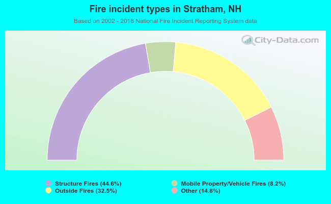 When looking into fire subcategories, the most incidents belonged to: Structure Fires (44.6%), and Outside Fires (32.5%).
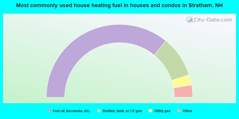
- 71.8%Fuel oil, kerosene, etc.
- 18.2%Bottled, tank, or LP gas
- 4.6%Utility gas
- 3.6%Electricity
- 0.8%Wood
- 0.5%Coal or coke
- 0.4%Other fuel
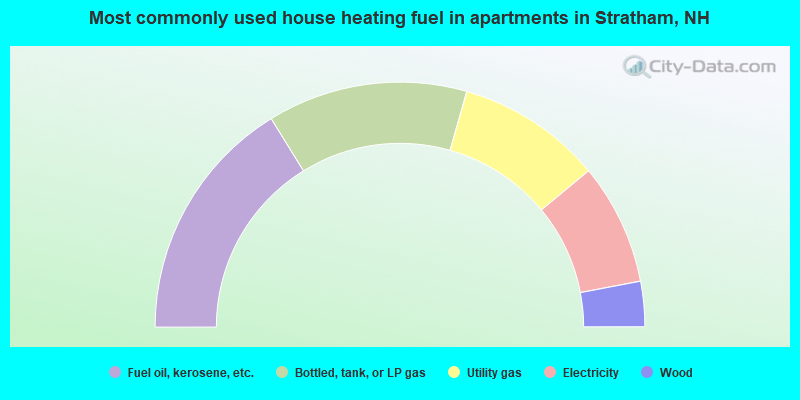
- 32.4%Fuel oil, kerosene, etc.
- 26.4%Bottled, tank, or LP gas
- 19.2%Utility gas
- 16.0%Electricity
- 6.0%Wood
Stratham compared to New Hampshire state average:
- Median household income above state average.
- Median house value above state average.
- Unemployed percentage significantly below state average.
- Black race population percentage significantly below state average.
- Hispanic race population percentage significantly below state average.
- Foreign-born population percentage below state average.
- Renting percentage significantly below state average.
- Length of stay since moving in significantly above state average.
- Number of rooms per house significantly below state average.
- House age significantly below state average.
- Percentage of population with a bachelor's degree or higher above state average.
Stratham on our top lists:
- #3 on the list of "Top 101 cities with largest percentage of females in occupations: supervisors of transportation and material moving workers (population 5,000+)"
- #4 on the list of "Top 101 cities with largest percentage of females in industries: petroleum and petroleum products merchant wholesalers (population 5,000+)"
- #7 on the list of "Top 101 cities with largest percentage of males in occupations: other sales and related workers including supervisors (population 5,000+)"
- #9 on the list of "Top 101 cities with largest percentage of males in industries: drugs, sundries, and chemical and allied products merchant wholesalers (population 5,000+)"
- #9 on the list of "Top 101 cities with largest percentage of females in industries: data processing, libraries, and other information services (population 5,000+)"
- #10 on the list of "Top 101 cities with largest percentage of females in occupations: special education teachers (population 5,000+)"
- #11 on the list of "Top 101 cities with largest percentage of males in occupations: air transportation workers (population 5,000+)"
- #12 on the list of "Top 101 cities with largest percentage of males in industries: personal and laundry services (population 5,000+)"
- #13 on the list of "Top 101 cities with largest percentage of females in industries: leather and allied products (population 5,000+)"
- #15 on the list of "Top 101 cities with largest percentage of females in industries: furniture and home furnishings, and household appliance stores (population 5,000+)"
- #17 on the list of "Top 101 cities with largest percentage of females in industries: radio, tv, and computer stores (population 5,000+)"
- #19 on the list of "Top 101 cities with largest percentage of males in industries: professional and commercial equipment and supplies merchant wholesalers (population 5,000+)"
- #19 on the list of "Top 101 cities with largest percentage of males in occupations: judges, magistrates, and other judicial workers (population 5,000+)"
- #20 on the list of "Top 101 cities with largest percentage of females in occupations: operations specialties managers except financial managers (population 5,000+)"
- #26 on the list of "Top 101 cities with largest percentage of males in industries: radio, tv, and computer stores (population 5,000+)"
- #32 on the list of "Top 101 cities with largest percentage of females in industries: sewing, needlework, and piece goods stores (population 5,000+)"
- #32 on the list of "Top 101 cities with largest percentage of males in industries: hardware, plumbing and heating equipment, and supplies merchant wholesalers (population 5,000+)"
- #38 on the list of "Top 101 cities with largest percentage of males in industries: apparel, fabrics, and notions merchant wholesalers (population 5,000+)"
- #57 on the list of "Top 101 cities with largest percentage of females in industries: professional and commercial equipment and supplies merchant wholesalers (population 5,000+)"
- #80 on the list of "Top 101 cities with largest percentage of males in industries: air transportation (population 5,000+)"
- #9 on the list of "Top 101 counties with the largest decrease in the number of births per 1000 residents 2000-2006 to 2007-2013 (pop 50,000+)"
- #14 on the list of "Top 101 counties with the best general health status score of residents (1-5), 3 years of data"
- #16 on the list of "Top 101 counties with the lowest number of births per 1000 residents 2007-2013"
- #22 on the list of "Top 101 counties with the lowest Particulate Matter (PM10) Annual air pollution readings in 2012 (µg/m3)"
- #36 on the list of "Top 101 counties with the highest percentage of residents that visited a dentist within the past year"

|
|
Total of 249 patent applications in 2008-2024.