Bridge Statistics for Providence, Rhode Island (RI)
Condition, Traffic, Stress, Structural Evaluation, Project Costs
- National Bridge Inventory (NBI) Statistics
- 224Number of bridges
- 3,862ft / 1,177mTotal length
- $846,417,000Total costs
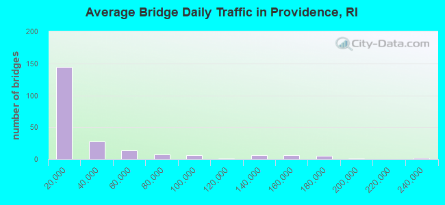
- 6,960,496Total average daily traffic
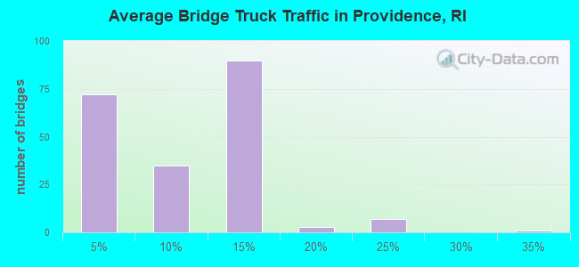
- 604,535Total average daily truck traffic
- National Bridge Inventory (NBI) Registered Bridges for Providence
- No street view available for this location
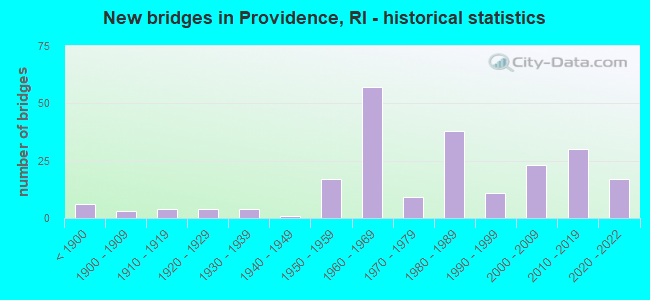
- New bridges - historical statistics
- 6Before 1900
- 31900-1909
- 41910-1919
- 41920-1929
- 41930-1939
- 11940-1949
- 171950-1959
- 571960-1969
- 91970-1979
- 381980-1989
- 111990-1999
- 232000-2009
- 302010-2019
- 172020-2022
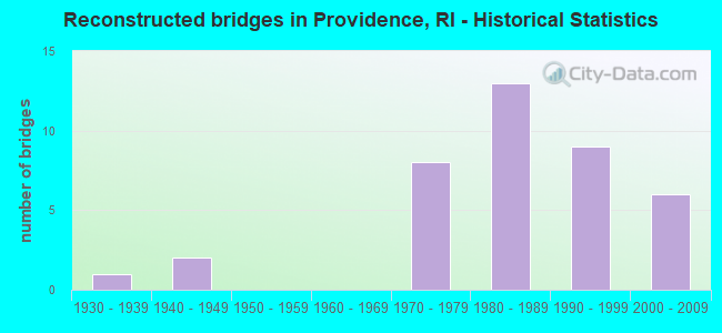
- Reconstructed bridges - Historical Statistics
- 11930-1939
- 21940-1949
- 01950-1959
- 01960-1969
- 81970-1979
- 131980-1989
- 91990-1999
- 62000-2009
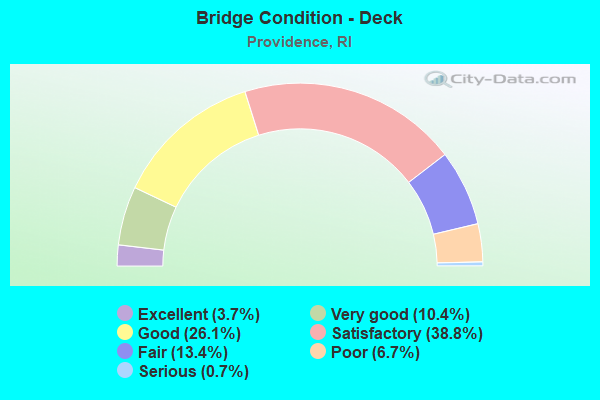
- Bridge Condition - Deck
- 3.7%Excellent
- 10.4%Very good
- 26.1%Good
- 38.8%Satisfactory
- 13.4%Fair
- 6.7%Poor
- 0.7%Serious
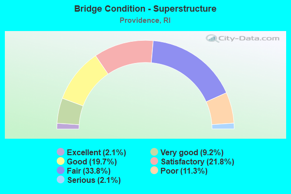
- Bridge Condition - Superstructure
- 2.1%Excellent
- 9.2%Very good
- 19.7%Good
- 21.8%Satisfactory
- 33.8%Fair
- 11.3%Poor
- 2.1%Serious
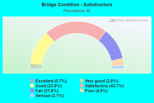
- Bridge Condition - Substructure
- 0.7%Excellent
- 2.8%Very good
- 23.9%Good
- 43.7%Satisfactory
- 21.8%Fair
- 4.9%Poor
- 2.1%Serious
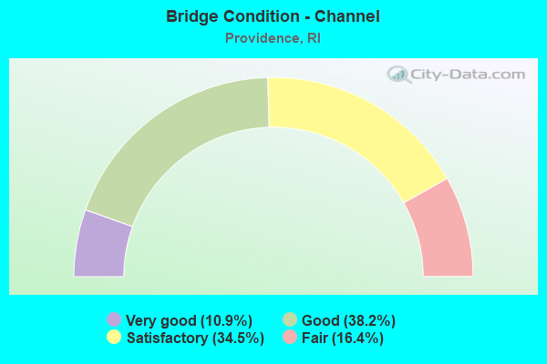
- Bridge Condition - Channel
- 10.9%Very good
- 38.2%Good
- 34.5%Satisfactory
- 16.4%Fair
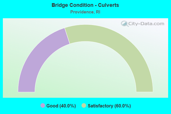
- Bridge Condition - Culverts
- 40.0%Good
- 60.0%Satisfactory
Find on map >> Show street view
Structure Number: 887, Location: 0.2 Mi E of JCT US 1 (Lat: 41.783872, Lng: -71.414533), Route carried "on" structure: City street , Year Built: 1957, Status: Open, Structure Length: 1.02m (3.35ft), Average Daily Traffic: 2,953 (year 2021), Truck Traffic: 4%, Average Future Daily Traffic: 3,248 (year 2041), Design Load: HS 20, Features Intersected: WILLIAMS LAKE, Facility Carried by Structure: CLADRASTIS AVE
Minimum Vertical Clearance: 30+ m (98+ ft), Kilometerpoint: 0.980, Lanes on structure: 2, Owner: Local Park, Forest, or Reservation Agency, Approaching Roadway Width: 9.1m (29.9ft), Material/Design: Steel, Design/Construction: Stringer/Multi-beam, Number Of Spans In Main Unit: 1, Length of Maximum Span: 9.9m (32.5ft), Curb or Sidewalk Widths: Left: 2.3m (7.5ft), Right: 1.6m (5.2ft), Curb-To-Curb Width: 9.1m (29.9ft), Out-to-Out Width: 13.0m (42.7ft)
Condition: Deck: Satisfactory, Superstructure: Fair, Substructure: Satisfactory, Channel: Very good, Operating Rating: 54.4 metric tons, Method Used To Determine Operating Rating: Load and Resistance Factor Rating (LRFR) rating reported by rating factor(RF) method using HL-93 loadings, Inventory Rating: 41.8 metric tons, Method Used To Determine Inventory Rating: Load and Resistance Factor Rating (LRFR) rating reported by rating factor(RF) method using HL-93 loadings, Structural Evaluation: Somewhat better than minimum adequacy, Deck Geometry: Meets minimum limits, Waterway Adequacy: Superior to present desirable criteria, Approach Roadway Alignment: Somewhat better than minimum adequacy, Length Of Structure Improvement: 1.01m (3.31ft), Designated Inspection Frequency: Every 24 months, Inspection Date: October 2021, Total Project Cost: $415,000, Deck Structure Type: Concrete Cast-file-Place, Wearing Surface/Protective System: Wearing Surface: Bituminous, Membrane: Built-up
Find on map >> Show street view
Structure Number: 888, Location: 0.2 Mi E of JCT I-95 (Lat: 41.784689, Lng: -71.415328), Route carried "on" structure: City street , Year Built: 1957, Status: Open, Structure Length: 1.11m (3.64ft), Average Daily Traffic: 3,035 (year 2021), Truck Traffic: 3%, Average Future Daily Traffic: 3,339 (year 2041), Features Intersected: ROOSEVELT LAKE, Facility Carried by Structure: MEMORIAL BLVD
Minimum Vertical Clearance: 30+ m (98+ ft), Kilometerpoint: 3.294, Lanes on structure: 2, Owner: Local Park, Forest, or Reservation Agency, Approaching Roadway Width: 9.8m (32.2ft), Material/Design: Steel, Design/Construction: Stringer/Multi-beam, Number Of Spans In Main Unit: 1, Length of Maximum Span: 9.9m (32.5ft), Curb or Sidewalk Widths: Left: 2.0m (6.6ft), Right: 1.5m (4.9ft), Curb-To-Curb Width: 9.8m (32.2ft), Out-to-Out Width: 13.7m (44.9ft)
Condition: Deck: Satisfactory, Superstructure: Satisfactory, Substructure: Satisfactory, Channel: Very good, Operating Rating: 41.5 metric tons, Method Used To Determine Operating Rating: Load and Resistance Factor Rating (LRFR) rating reported by rating factor(RF) method using HL-93 loadings, Inventory Rating: 32.1 metric tons, Method Used To Determine Inventory Rating: Load and Resistance Factor Rating (LRFR) rating reported by rating factor(RF) method using HL-93 loadings, Structural Evaluation: Equal to present minimum criteria, Deck Geometry: Meets minimum limits, Waterway Adequacy: Superior to present desirable criteria, Approach Roadway Alignment: Better than present minimum criteria, Length Of Structure Improvement: 1.01m (3.31ft), Designated Inspection Frequency: Every 24 months, Inspection Date: October 2021, Total Project Cost: $474,000, Deck Structure Type: Concrete Cast-file-Place, Wearing Surface/Protective System: Wearing Surface: Bituminous
Find on map >> Show street view
Structure Number: 889, Location: 0.7 Mi E of JCT US 1 (Lat: 41.786197, Lng: -71.414919), Route carried "on" structure: City street , Year Built: 1889, Status: Posted for load, Structure Length: 0.91m (2.99ft), Average Daily Traffic: 6,746 (year 2021), Truck Traffic: 3%, Average Future Daily Traffic: 7,421 (year 2041), Features Intersected: POLO LAKE, Facility Carried by Structure: MEMORIAL BLVD
Minimum Vertical Clearance: 30+ m (98+ ft), Kilometerpoint: 5.351, Lanes on structure: 2, Owner: Local Park, Forest, or Reservation Agency, Approaching Roadway Width: 8.7m (28.5ft), Material/Design: Masonry, Design/Construction: Arch - Deck, Number Of Spans In Main Unit: 1, Length of Maximum Span: 9.1m (29.9ft), Curb or Sidewalk Widths: Left: 0.0m, Right: 1.1m (3.6ft), Curb-To-Curb Width: 9.1m (29.9ft), Out-to-Out Width: 11.6m (38.1ft)
Condition: Superstructure: Fair, Substructure: Fair, Channel: Good, Operating Rating: 27.3 metric tons, Method Used To Determine Operating Rating: Allowable Stress (AS), Inventory Rating: 16.3 metric tons, Method Used To Determine Inventory Rating: Allowable Stress (AS), Structural Evaluation: Meets minimum limits, Deck Geometry: High priority of corrective action, Waterway Adequacy: Equal to present desirable criteria, Approach Roadway Alignment: Better than present minimum criteria, Bridge Posting: Required (Relationship of Operating Rating to Maximum Legal Load: > 39.9% below), Length Of Structure Improvement: 1.23m (4.04ft), Designated Inspection Frequency: Every 24 months, Other Special Inspection Frequency: Every 12 months, Inspection Date: October 2021, Other Special Inspection Date: October 2021, Bridge Improvement Cost: $298,000, Roadway Improvement Cost: $30,000, Total Project Cost: $447,000
Find on map >> Show street view
Structure Number: 89, Location: 0.1 Mi E of Branch Av (Lat: 41.855614, Lng: -71.434367), Route carried "on" structure: City street , Year Built: 1913, Year Reconstructed: 1990, Status: Posted for load, Structure Length: 1.07m (3.51ft), Average Daily Traffic: 2,222 (year 2021), Truck Traffic: 10%, Average Future Daily Traffic: 2,444 (year 2041), Features Intersected: WEST RIVER, Facility Carried by Structure: VEAZIE ST
Minimum Vertical Clearance: 30+ m (98+ ft), Kilometerpoint: 0.591, Lanes on structure: 2, Owner: City or Municipal Highway Agency, Approaching Roadway Width: 7.3m (24.0ft), Material/Design: Steel, Design/Construction: Stringer/Multi-beam, Number Of Spans In Main Unit: 1, Length of Maximum Span: 8.9m (29.2ft), Curb or Sidewalk Widths: Left: 2.2m (7.2ft), Right: 2.2m (7.2ft), Curb-To-Curb Width: 7.3m (24.0ft), Out-to-Out Width: 12.3m (40.4ft)
Condition: Deck: Good, Superstructure: Poor, Substructure: Fair, Channel: Fair, Operating Rating: 36.0 metric tons, Method Used To Determine Operating Rating: Load and Resistance Factor Rating (LRFR) rating reported by rating factor(RF) method using HL-93 loadings, Inventory Rating: 27.9 metric tons, Method Used To Determine Inventory Rating: Load and Resistance Factor Rating (LRFR) rating reported by rating factor(RF) method using HL-93 loadings, Structural Evaluation: Meets minimum limits, Deck Geometry: High priority of replacement, Waterway Adequacy: Superior to present desirable criteria, Approach Roadway Alignment: Equal to present desirable criteria, Bridge Posting: Required (Relationship of Operating Rating to Maximum Legal Load: 10.0 - 19.9% below), Length Of Structure Improvement: 1.07m (3.51ft), Designated Inspection Frequency: Every 24 months, Other Special Inspection Frequency: Every 12 months, Inspection Date: November 2021, Other Special Inspection Date: November 2021, Bridge Improvement Cost: $138,000, Roadway Improvement Cost: $14,000, Total Project Cost: $207,000, Deck Structure Type: Concrete Cast-file-Place, Wearing Surface/Protective System: Wearing Surface: Bituminous
Find on map >> Show street view
Structure Number: 923, Location: 0.1 Mi N of JCT I-95 (Lat: 41.788500, Lng: -71.422258), Route carried "on" structure: City street , Year Built: 2001, Status: Open, Structure Length: 3.06m (10.04ft), Average Daily Traffic: 13,750 (year 2021), Truck Traffic: 4%, Average Future Daily Traffic: 15,125 (year 2041), Design Load: HS 20, Features Intersected: AMTRAK & P&W RR, Facility Carried by Structure: ROGER WILLIAMS AV
Minimum Vertical Clearance: 30+ m (98+ ft), Kilometerpoint: 0.650, Lanes on structure: 2, Owner: City or Municipal Highway Agency, Approaching Roadway Width: 11.6m (38.1ft), Skew: 2 degrees, Material/Design: Steel, Design/Construction: Girder and Floorbeam System, Number Of Spans In Main Unit: 1, Length of Maximum Span: 28.0m (91.9ft), Curb or Sidewalk Widths: Left: 2.6m (8.5ft), Right: 2.6m (8.5ft), Curb-To-Curb Width: 11.7m (38.4ft), Out-to-Out Width: 19.2m (63.0ft)
Condition: Deck: Good, Superstructure: Good, Substructure: Good, Operating Rating: 53.8 metric tons, Method Used To Determine Operating Rating: Load and Resistance Factor Rating (LRFR) rating reported by rating factor(RF) method using HL-93 loadings, Inventory Rating: 41.5 metric tons, Method Used To Determine Inventory Rating: Load and Resistance Factor Rating (LRFR) rating reported by rating factor(RF) method using HL-93 loadings, Structural Evaluation: Better than present minimum criteria, Deck Geometry: Somewhat better than minimum adequacy, Underclear: Meets minimum limits, Approach Roadway Alignment: Somewhat better than minimum adequacy, Length Of Structure Improvement: 3.06m (10.04ft), Designated Inspection Frequency: Every 24 months, Critical Feature Inspection Frequency: Every 12 months, Inspection Date: September 2021, Critical Feature Inspection Date: September 2021, Bridge Improvement Cost: $1,763,000, Roadway Improvement Cost: $176,000, Total Project Cost: $2,644,000, Deck Structure Type: Concrete Cast-file-Place, Wearing Surface/Protective System: Wearing Surface: Monolithic Concrete, Deck Protection: Epoxy Coated Reinforcing
Find on map >> Show street view
Structure Number: 925, Location: 0.5 Mi S of JCT US 6 (Lat: 41.808392, Lng: -71.441669), Route carried "on" structure: City street , Year Built: 1922, Year Reconstructed: 1993, Status: Open, Structure Length: 2.71m (8.89ft), Average Daily Traffic: 21,312 (year 2015), Truck Traffic: 10%, Average Future Daily Traffic: 25,575 (year 2036), Design Load: HS 20, Features Intersected: AMTRAK & P&W RR, Facility Carried by Structure: UNION AV
Minimum Vertical Clearance: 30+ m (98+ ft), Kilometerpoint: 1.328, Lanes on structure: 2, Owner: City or Municipal Highway Agency, Approaching Roadway Width: 10.5m (34.4ft), Skew: 2 degrees, Material/Design: Steel, Design/Construction: Stringer/Multi-beam, Number Of Spans In Main Unit: 1, Length of Maximum Span: 26.2m (86.0ft), Curb or Sidewalk Widths: Left: 1.5m (4.9ft), Right: 1.5m (4.9ft), Curb-To-Curb Width: 10.5m (34.4ft), Out-to-Out Width: 14.1m (46.3ft)
Condition: Deck: Satisfactory, Superstructure: Good, Substructure: Satisfactory, Operating Rating: 67.4 metric tons, Method Used To Determine Operating Rating: Load and Resistance Factor Rating (LRFR) rating reported by rating factor(RF) method using HL-93 loadings, Inventory Rating: 51.5 metric tons, Method Used To Determine Inventory Rating: Load and Resistance Factor Rating (LRFR) rating reported by rating factor(RF) method using HL-93 loadings, Structural Evaluation: Equal to present minimum criteria, Deck Geometry: Meets minimum limits, Underclear: High priority of corrective action, Approach Roadway Alignment: Equal to present desirable criteria, Length Of Structure Improvement: 2.59m (8.50ft), Designated Inspection Frequency: Every 24 months, Inspection Date: July 2021, Bridge Improvement Cost: $782,000, Roadway Improvement Cost: $78,000, Total Project Cost: $1,174,000, Deck Structure Type: Concrete Cast-file-Place, Wearing Surface/Protective System: Wearing Surface: Latex Concrete, Deck Protection: Epoxy Coated Reinforcing
Find on map >> Show street view
Structure Number: 926, Location: 0.1 Mi W of RI 10 (Lat: 41.816108, Lng: -71.439925), Route carried "on" structure: Business City street , Year Built: 1995, Status: Open, Structure Length: 1.98m (6.50ft), Average Daily Traffic: 21,211 (year 2015), Truck Traffic: 10%, Average Future Daily Traffic: 25,454 (year 2036), Design Load: HS 25 or greater, Features Intersected: AMTRAK & P&W RR, Facility Carried by Structure: WESTMINSTER ST
Minimum Vertical Clearance: 30+ m (98+ ft), Kilometerpoint: 1.914, Lanes on structure: 2, Owner: City or Municipal Highway Agency, Approaching Roadway Width: 13.4m (44.0ft), Skew: 1 degrees, Material/Design: Prestressed concrete, Design/Construction: Box Beam or Girders - Multiple, Number Of Spans In Main Unit: 2, Length of Maximum Span: 10.4m (34.1ft), Curb or Sidewalk Widths: Left: 1.8m (5.9ft), Right: 1.8m (5.9ft), Curb-To-Curb Width: 13.4m (44.0ft), Out-to-Out Width: 17.7m (58.1ft)
Condition: Deck: Satisfactory, Superstructure: Satisfactory, Substructure: Good, Operating Rating: 63.8 metric tons, Method Used To Determine Operating Rating: Load and Resistance Factor Rating (LRFR) rating reported by rating factor(RF) method using HL-93 loadings, Inventory Rating: 49.2 metric tons, Method Used To Determine Inventory Rating: Load and Resistance Factor Rating (LRFR) rating reported by rating factor(RF) method using HL-93 loadings, Structural Evaluation: Equal to present minimum criteria, Deck Geometry: Equal to present minimum criteria, Underclear: High priority of corrective action, Approach Roadway Alignment: Equal to present desirable criteria, Length Of Structure Improvement: 2.01m (6.59ft), Designated Inspection Frequency: Every 24 months, Inspection Date: August 2021, Bridge Improvement Cost: $718,000, Roadway Improvement Cost: $72,000, Total Project Cost: $1,077,000, Deck Structure Type: Concrete Cast-file-Place, Wearing Surface/Protective System: Wearing Surface: Bituminous, Membrane: Built-up
Find on map >> Show street view
Structure Number: 927, Location: 0.4 Mi N of JCT US 6 (Lat: 41.817267, Lng: -71.439628), Route carried "on" structure: City street , Year Built: 1994, Status: Open, Structure Length: 2.53m (8.30ft), Average Daily Traffic: 20,278 (year 2015), Truck Traffic: 10%, Average Future Daily Traffic: 24,334 (year 2036), Design Load: HS 20, Features Intersected: AMTRAK & P&W RR, Facility Carried by Structure: BROADWAY
Minimum Vertical Clearance: 30+ m (98+ ft), Kilometerpoint: 1.736, Lanes on structure: 4, Owner: City or Municipal Highway Agency, Approaching Roadway Width: 18.3m (60.0ft), Skew: 3 degrees, Material/Design: Prestressed concrete, Design/Construction: Slab, Number Of Spans In Main Unit: 2, Length of Maximum Span: 15.2m (49.9ft), Curb or Sidewalk Widths: Left: 1.8m (5.9ft), Right: 1.8m (5.9ft), Curb-To-Curb Width: 18.3m (60.0ft), Out-to-Out Width: 22.6m (74.1ft)
Condition: Deck: Satisfactory, Superstructure: Poor, Substructure: Satisfactory, Operating Rating: 79.7 metric tons, Method Used To Determine Operating Rating: Load and Resistance Factor Rating (LRFR) rating reported by rating factor(RF) method using HL-93 loadings, Inventory Rating: 61.6 metric tons, Method Used To Determine Inventory Rating: Load and Resistance Factor Rating (LRFR) rating reported by rating factor(RF) method using HL-93 loadings, Structural Evaluation: Meets minimum limits, Deck Geometry: Somewhat better than minimum adequacy, Underclear: High priority of corrective action, Approach Roadway Alignment: Equal to present desirable criteria, Length Of Structure Improvement: 2.65m (8.69ft), Designated Inspection Frequency: Every 24 months, Other Special Inspection Frequency: Every 12 months, Inspection Date: July 2021, Other Special Inspection Date: July 2021, Bridge Improvement Cost: $1,247,000, Roadway Improvement Cost: $125,000, Total Project Cost: $1,870,000, Deck Structure Type: Concrete Precast Panels, Wearing Surface/Protective System: Wearing Surface: Bituminous, Membrane: Built-up
Find on map >> Show street view
Structure Number: 928, Location: 0.1 Mi W of No Main St (Lat: 41.831492, Lng: -71.412372), Route carried "on" structure: US 44, Year Built: 1900, Year Reconstructed: 1981, Status: Open, Structure Length: 2.98m (9.78ft), Average Daily Traffic: 12,323 (year 2014), Truck Traffic: 1%, Average Future Daily Traffic: 14,788 (year 2036), Design Load: HS 20, Features Intersected: AMTRAK & P&W RR
Minimum Vertical Clearance: 30+ m (98+ ft), Kilometerpoint: 35.547, Lanes on structure: 4, Base Highway Network: Yes, Owner: State Highway Agency, Approaching Roadway Width: 16.2m (53.1ft), Skew: 1 degrees, Material/Design: Steel, Design/Construction: Stringer/Multi-beam, Number Of Spans In Main Unit: 1, Length of Maximum Span: 28.3m (92.8ft), Curb or Sidewalk Widths: Left: 2.1m (6.9ft), Right: 2.1m (6.9ft), Curb-To-Curb Width: 16.2m (53.1ft), Out-to-Out Width: 21.0m (68.9ft)
Condition: Deck: Satisfactory, Superstructure: Fair, Substructure: Satisfactory, Operating Rating: 64.8 metric tons, Method Used To Determine Operating Rating: Load and Resistance Factor Rating (LRFR) rating reported by rating factor(RF) method using HL-93 loadings, Inventory Rating: 51.8 metric tons, Method Used To Determine Inventory Rating: Load and Resistance Factor Rating (LRFR) rating reported by rating factor(RF) method using HL-93 loadings, Structural Evaluation: Somewhat better than minimum adequacy, Deck Geometry: Meets minimum limits, Underclear: High priority of corrective action, Approach Roadway Alignment: Equal to present minimum criteria, Length Of Structure Improvement: 2.90m (9.51ft), Designated Inspection Frequency: Every 24 months, Inspection Date: July 2021, Bridge Improvement Cost: $1,115,000, Roadway Improvement Cost: $112,000, Total Project Cost: $1,673,000, Deck Structure Type: Concrete Cast-file-Place, Wearing Surface/Protective System: Wearing Surface: Monolithic Concrete
Find on map >> Show street view
Structure Number: 929, Location: 0.1 Mi W of No Main St (Lat: 41.834819, Lng: -71.413911), Route carried "on" structure: State highway 7, Year Built: 1936, Year Reconstructed: 1979, Status: Open, Structure Length: 4.09m (13.42ft), Average Daily Traffic: 16,565 (year 2014), Truck Traffic: 10%, Average Future Daily Traffic: 19,878 (year 2036), Design Load: HS 20, Features Intersected: AMTRAK & P&W RR
Minimum Vertical Clearance: 30+ m (98+ ft), Kilometerpoint: 0.203, Lanes on structure: 4, Base Highway Network: Yes, Owner: City or Municipal Highway Agency, Approaching Roadway Width: 16.6m (54.5ft), Skew: 2 degrees, Material/Design: Steel, Design/Construction: Stringer/Multi-beam, Number Of Spans In Main Unit: 2, Length of Maximum Span: 29.9m (98.1ft), Curb or Sidewalk Widths: Left: 4.5m (14.8ft), Right: 4.4m (14.4ft), Curb-To-Curb Width: 16.6m (54.5ft), Out-to-Out Width: 25.6m (84.0ft)
Condition: Deck: Satisfactory, Superstructure: Fair, Substructure: Fair, Operating Rating: 25.9 metric tons, Method Used To Determine Operating Rating: Load and Resistance Factor Rating (LRFR) rating reported by rating factor(RF) method using HL-93 loadings, Inventory Rating: 19.4 metric tons, Method Used To Determine Inventory Rating: Load and Resistance Factor Rating (LRFR) rating reported by rating factor(RF) method using HL-93 loadings, Structural Evaluation: Meets minimum limits, Deck Geometry: Somewhat better than minimum adequacy, Underclear: Meets minimum limits, Approach Roadway Alignment: Equal to present desirable criteria, Length Of Structure Improvement: 4.08m (13.39ft), Designated Inspection Frequency: Every 24 months, Inspection Date: August 2021, Bridge Improvement Cost: $1,802,000, Roadway Improvement Cost: $180,000, Total Project Cost: $2,703,000, Deck Structure Type: Concrete Cast-file-Place, Wearing Surface/Protective System: Wearing Surface: Monolithic Concrete
Find on map >> Show street view
Structure Number: 93, Location: 0.3 Mi N of Orms St (Lat: 41.839964, Lng: -71.416858), Route carried "on" structure: State highway 246, Year Built: 1977, Status: Open, Structure Length: 4.36m (14.30ft), Average Daily Traffic: 21,009 (year 2014), Truck Traffic: 2%, Average Future Daily Traffic: 25,211 (year 2036), Design Load: HS 20, Features Intersected: AMTRAK & P&W RR, Facility Carried by Structure: CHARLES ST
Minimum Vertical Clearance: 30+ m (98+ ft), Kilometerpoint: 1.102, Lanes on structure: 3, Base Highway Network: Yes, Owner: State Highway Agency, Approaching Roadway Width: 12.2m (40.0ft), Skew: 3 degrees, Material/Design: Steel, Design/Construction: Stringer/Multi-beam, Number Of Spans In Main Unit: 1, Length of Maximum Span: 40.4m (132.5ft), Curb or Sidewalk Widths: Left: 1.5m (4.9ft), Right: 1.5m (4.9ft), Curb-To-Curb Width: 12.2m (40.0ft), Out-to-Out Width: 15.8m (51.8ft)
Condition: Deck: Good, Superstructure: Fair, Substructure: Satisfactory, Operating Rating: 46.0 metric tons, Method Used To Determine Operating Rating: Load and Resistance Factor Rating (LRFR) rating reported by rating factor(RF) method using HL-93 loadings, Inventory Rating: 35.3 metric tons, Method Used To Determine Inventory Rating: Load and Resistance Factor Rating (LRFR) rating reported by rating factor(RF) method using HL-93 loadings, Structural Evaluation: Somewhat better than minimum adequacy, Deck Geometry: Meets minimum limits, Underclear: High priority of corrective action, Approach Roadway Alignment: Somewhat better than minimum adequacy, Length Of Structure Improvement: 4.33m (14.21ft), Designated Inspection Frequency: Every 24 months, Inspection Date: August 2021, Bridge Improvement Cost: $1,010,000, Roadway Improvement Cost: $101,000, Total Project Cost: $1,515,000, Deck Structure Type: Concrete Cast-file-Place, Wearing Surface/Protective System: Wearing Surface: Bituminous
Find on map >> Show street view
Structure Number: 931, Location: 0.4 MI N of Douglas Av (Lat: 41.847108, Lng: -71.413139), Route carried "on" structure: City street , Year Built: 1984, Status: Open, Structure Length: 15.09m (49.51ft), Average Daily Traffic: 19,191 (year 2015), Truck Traffic: 10%, Average Future Daily Traffic: 23,030 (year 2036), Design Load: HS 20, Features Intersected: AMTRAK & P&W RR, Facility Carried by Structure: BRANCH AV
Minimum Vertical Clearance: 30+ m (98+ ft), Kilometerpoint: 2.488, Lanes on structure: 4, Lanes under structure: 2, Owner: City or Municipal Highway Agency, Approaching Roadway Width: 19.8m (65.0ft), Skew: 1 degrees, Material/Design: Steel, Design/Construction: Stringer/Multi-beam, Number Of Spans In Main Unit: 4, Length of Maximum Span: 38.1m (125.0ft), Curb or Sidewalk Widths: Left: 1.5m (4.9ft), Right: 1.5m (4.9ft), Curb-To-Curb Width: 16.5m (54.1ft), Out-to-Out Width: 20.1m (65.9ft)
Condition: Deck: Satisfactory, Superstructure: Fair, Substructure: Satisfactory, Operating Rating: 47.2 metric tons, Method Used To Determine Operating Rating: Load and Resistance Factor (LRFR), Inventory Rating: 36.3 metric tons, Method Used To Determine Inventory Rating: Load and Resistance Factor (LRFR), Structural Evaluation: Somewhat better than minimum adequacy, Deck Geometry: Meets minimum limits, Underclear: High priority of corrective action, Approach Roadway Alignment: Better than present minimum criteria, Length Of Structure Improvement: 15.09m (49.51ft), Designated Inspection Frequency: Every 24 months, Inspection Date: October 2021, Bridge Improvement Cost: $9,647,000, Roadway Improvement Cost: $965,000, Total Project Cost: $14,471,000, Deck Structure Type: Concrete Cast-file-Place, Wearing Surface/Protective System: Wearing Surface: Bituminous, Membrane: Built-up, Deck Protection: Epoxy Coated Reinforcing
Find on map >> Show street view
Structure Number: 932, Location: 0.1 Mi E of Silver Spring (Lat: 41.855947, Lng: -71.407919), Route carried "on" structure: State highway 126, Year Built: 1984, Status: Open, Structure Length: 20.29m (66.57ft), Average Daily Traffic: 13,535 (year 2014), Truck Traffic: 3%, Average Future Daily Traffic: 16,242 (year 2036), Design Load: HS 20, Features Intersected: AMTRAK & P&W RR
Minimum Vertical Clearance: 30+ m (98+ ft), Kilometerpoint: 0.726, Lanes on structure: 4, Lanes under structure: 2, Base Highway Network: Yes, Owner: State Highway Agency, Approaching Roadway Width: 18.6m (61.0ft), Skew: 20 degrees, Material/Design: Steel continuous, Design/Construction: Stringer/Multi-beam, Number Of Spans In Main Unit: 5, Length of Maximum Span: 45.7m (149.9ft), Curb or Sidewalk Widths: Left: 1.5m (4.9ft), Right: 1.5m (4.9ft), Curb-To-Curb Width: 18.7m (61.4ft), Out-to-Out Width: 22.3m (73.2ft)
Condition: Deck: Fair, Superstructure: Satisfactory, Substructure: Fair, Operating Rating: 46.3 metric tons, Method Used To Determine Operating Rating: Load and Resistance Factor Rating (LRFR) rating reported by rating factor(RF) method using HL-93 loadings, Inventory Rating: 36.0 metric tons, Method Used To Determine Inventory Rating: Load and Resistance Factor Rating (LRFR) rating reported by rating factor(RF) method using HL-93 loadings, Structural Evaluation: Somewhat better than minimum adequacy, Deck Geometry: Equal to present minimum criteria, Underclear: High priority of corrective action, Approach Roadway Alignment: Better than present minimum criteria, Length Of Structure Improvement: 20.18m (66.21ft), Designated Inspection Frequency: Every 24 months, Other Special Inspection Frequency: Every 12 months, Inspection Date: December 2021, Other Special Inspection Date: December 2021, Bridge Improvement Cost: $9,365,000, Roadway Improvement Cost: $936,000, Total Project Cost: $14,047,000, Deck Structure Type: Concrete Cast-file-Place, Wearing Surface/Protective System: Wearing Surface: Bituminous
Find on map >> Show street view
Structure Number: 972, Location: 0.1 Mi E of Valley St (Lat: 41.826561, Lng: -71.435708), Route carried "on" structure: City street , Year Built: 1931, Year Reconstructed: 1992, Status: Posted for load, Structure Length: 1.36m (4.46ft), Average Daily Traffic: 8,137 (year 2021), Truck Traffic: 2%, Average Future Daily Traffic: 8,951 (year 2041), Design Load: HS 20, Features Intersected: WOONASQUATUCKET RIVER, Facility Carried by Structure: EAGLE ST
Minimum Vertical Clearance: 30+ m (98+ ft), Kilometerpoint: 0.249, Lanes on structure: 3, Owner: City or Municipal Highway Agency, Approaching Roadway Width: 9.3m (30.5ft), Skew: 1 degrees, Material/Design: Steel, Design/Construction: Girder and Floorbeam System, Number Of Spans In Main Unit: 1, Length of Maximum Span: 12.5m (41.0ft), Curb or Sidewalk Widths: Left: 2.2m (7.2ft), Right: 6.0m (19.7ft), Curb-To-Curb Width: 10.7m (35.1ft), Out-to-Out Width: 19.5m (64.0ft)
Condition: Deck: Good, Superstructure: Fair, Substructure: Satisfactory, Channel: Good, Operating Rating: 37.6 metric tons, Method Used To Determine Operating Rating: Load and Resistance Factor Rating (LRFR) rating reported by rating factor(RF) method using HL-93 loadings, Inventory Rating: 29.2 metric tons, Method Used To Determine Inventory Rating: Load and Resistance Factor Rating (LRFR) rating reported by rating factor(RF) method using HL-93 loadings, Structural Evaluation: Somewhat better than minimum adequacy, Deck Geometry: High priority of replacement, Waterway Adequacy: Equal to present desirable criteria, Approach Roadway Alignment: Better than present minimum criteria, Bridge Posting: Required (Relationship of Operating Rating to Maximum Legal Load: 0.1 - 9.9% below), Length Of Structure Improvement: 1.37m (4.49ft), Designated Inspection Frequency: Every 24 months, Other Special Inspection Frequency: Every 12 months, Inspection Date: December 2021, Other Special Inspection Date: December 2021, Bridge Improvement Cost: $35,000, Roadway Improvement Cost: $4,000, Total Project Cost: $53,000, Deck Structure Type: Concrete Cast-file-Place, Wearing Surface/Protective System: Wearing Surface: Bituminous
Find on map >> Show street view
Structure Number: 973, Location: 0.25 Mi N of Admiral St (Lat: 41.844239, Lng: -71.418506), Route carried "on" structure: State highway 246, Year Built: 1894, Year Reconstructed: 1992, Status: Open, Structure Length: 1.05m (3.44ft), Average Daily Traffic: 7,777 (year 2015), Truck Traffic: 5%, Average Future Daily Traffic: 9,333 (year 2036), Design Load: HS 20, Features Intersected: WEST RIVER, Facility Carried by Structure: CHARLES ST
Minimum Vertical Clearance: 30+ m (98+ ft), Kilometerpoint: 1.601, Lanes on structure: 2, Owner: City or Municipal Highway Agency, Approaching Roadway Width: 10.4m (34.1ft), Skew: 1 degrees, Material/Design: Steel, Design/Construction: Stringer/Multi-beam, Number Of Spans In Main Unit: 1, Length of Maximum Span: 9.1m (29.9ft), Curb or Sidewalk Widths: Left: 2.0m (6.6ft), Right: 2.1m (6.9ft), Curb-To-Curb Width: 10.4m (34.1ft), Out-to-Out Width: 15.4m (50.5ft)
Condition: Deck: Good, Superstructure: Good, Substructure: Good, Channel: Fair, Operating Rating: 66.4 metric tons, Method Used To Determine Operating Rating: Load and Resistance Factor Rating (LRFR) rating reported by rating factor(RF) method using HL-93 loadings, Inventory Rating: 51.2 metric tons, Method Used To Determine Inventory Rating: Load and Resistance Factor Rating (LRFR) rating reported by rating factor(RF) method using HL-93 loadings, Structural Evaluation: Better than present minimum criteria, Deck Geometry: Meets minimum limits, Waterway Adequacy: Better than present minimum criteria, Approach Roadway Alignment: Equal to present desirable criteria, Length Of Structure Improvement: 0.88m (2.89ft), Designated Inspection Frequency: Every 24 months, Inspection Date: November 2021, Bridge Improvement Cost: $652,000, Roadway Improvement Cost: $65,000, Total Project Cost: $979,000, Deck Structure Type: Concrete Cast-file-Place, Wearing Surface/Protective System: Wearing Surface: Bituminous, Membrane: Preformed Fabric, Deck Protection: Epoxy Coated Reinforcing
Find on map >> Show street view
Structure Number: 974, Location: 0.5 Mi N of JCT RI 44 (Lat: 41.836519, Lng: -71.411703), Route carried "on" structure: City street , Year Built: 1916, Year Reconstructed: 2012, Status: Open, Structure Length: 1.54m (5.05ft), Average Daily Traffic: 7,957 (year 2021), Truck Traffic: 10%, Average Future Daily Traffic: 8,753 (year 2041), Design Load: HL 93, Features Intersected: MOSHASSUCK RIVER, Facility Carried by Structure: RANDALL ST
Minimum Vertical Clearance: 30+ m (98+ ft), Kilometerpoint: 0.048, Lanes on structure: 3, Owner: City or Municipal Highway Agency, Approaching Roadway Width: 12.2m (40.0ft), Skew: 3 degrees, Material/Design: Steel, Design/Construction: Stringer/Multi-beam, Number Of Spans In Main Unit: 1, Length of Maximum Span: 13.7m (44.9ft), Curb or Sidewalk Widths: Left: 3.0m (9.8ft), Right: 3.0m (9.8ft), Curb-To-Curb Width: 12.2m (40.0ft), Out-to-Out Width: 18.3m (60.0ft)
Condition: Deck: Satisfactory, Superstructure: Very good, Substructure: Good, Channel: Fair, Operating Rating: 97.2 metric tons, Method Used To Determine Operating Rating: Load and Resistance Factor Rating (LRFR) rating reported by rating factor(RF) method using HL-93 loadings, Inventory Rating: 97.2 metric tons, Method Used To Determine Inventory Rating: Load and Resistance Factor Rating (LRFR) rating reported by rating factor(RF) method using HL-93 loadings, Structural Evaluation: Better than present minimum criteria, Deck Geometry: Meets minimum limits, Waterway Adequacy: Superior to present desirable criteria, Approach Roadway Alignment: Equal to present desirable criteria, Length Of Structure Improvement: 1.01m (3.31ft), Designated Inspection Frequency: Every 24 months, Inspection Date: April 2020, Bridge Improvement Cost: $569,000, Roadway Improvement Cost: $57,000, Total Project Cost: $854,000, Deck Structure Type: Concrete Cast-file-Place, Wearing Surface/Protective System: Wearing Surface: Monolithic Concrete, Deck Protection: Galvanized Reinforcing
Find on map >> Show street view
Structure Number: 9755, Location: 0.5 Mi W of RI 10 (Lat: 41.824525, Lng: -71.438267), Route carried "on" structure: City street , Year Built: 2015, Status: Open, Structure Length: 1.40m (4.59ft), Average Daily Traffic: 10,681 (year 2021), Truck Traffic: 3%, Average Future Daily Traffic: 11,749 (year 2041), Design Load: HL 93, Features Intersected: WOONASQUATUCKET RIVER, Facility Carried by Structure: ATWELLS AV
Minimum Vertical Clearance: 30+ m (98+ ft), Kilometerpoint: 1.368, Lanes on structure: 3, Owner: City or Municipal Highway Agency, Approaching Roadway Width: 11.9m (39.0ft), Material/Design: Steel, Design/Construction: Stringer/Multi-beam, Number Of Spans In Main Unit: 1, Length of Maximum Span: 13.4m (44.0ft), Curb or Sidewalk Widths: Left: 2.7m (8.9ft), Right: 1.8m (5.9ft), Curb-To-Curb Width: 11.9m (39.0ft), Out-to-Out Width: 18.3m (60.0ft)
Condition: Deck: Very good, Superstructure: Very good, Substructure: Good, Channel: Good, Operating Rating: 79.7 metric tons, Method Used To Determine Operating Rating: Load and Resistance Factor Rating (LRFR) rating reported by rating factor(RF) method using HL-93 loadings, Inventory Rating: 61.6 metric tons, Method Used To Determine Inventory Rating: Load and Resistance Factor Rating (LRFR) rating reported by rating factor(RF) method using HL-93 loadings, Structural Evaluation: Better than present minimum criteria, Deck Geometry: High priority of corrective action, Waterway Adequacy: Somewhat better than minimum adequacy, Approach Roadway Alignment: Equal to present desirable criteria, Length Of Structure Improvement: 1.22m (4.00ft), Designated Inspection Frequency: Every 24 months, Inspection Date: May 2021, Bridge Improvement Cost: $564,000, Roadway Improvement Cost: $56,000, Total Project Cost: $846,000, Deck Structure Type: Other, Wearing Surface/Protective System: Wearing Surface: Bituminous, Membrane: Preformed Fabric, Deck Protection: Galvanized Reinforcing
Find on map >> Show street view
Structure Number: 976, Location: 0.1 Mi W of JCT RI 146 (Lat: 41.853578, Lng: -71.428392), Route carried "on" structure: City street , Year Built: 2013, Status: Open, Structure Length: 1.47m (4.82ft), Average Daily Traffic: 23,150 (year 2021), Truck Traffic: 3%, Average Future Daily Traffic: 25,465 (year 2041), Design Load: HS 25 or greater, Features Intersected: WEST RIVER, Facility Carried by Structure: BRANCH AV
Minimum Vertical Clearance: 30+ m (98+ ft), Kilometerpoint: 1.080, Lanes on structure: 2, Owner: City or Municipal Highway Agency, Approaching Roadway Width: 8.5m (27.9ft), Skew: 1 degrees, Material/Design: Prestressed concrete, Design/Construction: Box Beam or Girders - Multiple, Number Of Spans In Main Unit: 1, Length of Maximum Span: 14.0m (45.9ft), Curb or Sidewalk Widths: Left: 1.9m (6.2ft), Right: 1.9m (6.2ft), Curb-To-Curb Width: 8.5m (27.9ft), Out-to-Out Width: 13.7m (44.9ft)
Condition: Superstructure: Satisfactory, Substructure: Good, Channel: Satisfactory, Operating Rating: 54.8 metric tons, Method Used To Determine Operating Rating: Load and Resistance Factor Rating (LRFR) rating reported by rating factor(RF) method using HL-93 loadings, Inventory Rating: 40.5 metric tons, Method Used To Determine Inventory Rating: Load and Resistance Factor Rating (LRFR) rating reported by rating factor(RF) method using HL-93 loadings, Structural Evaluation: Equal to present minimum criteria, Deck Geometry: High priority of replacement, Waterway Adequacy: Superior to present desirable criteria, Approach Roadway Alignment: Better than present minimum criteria, Length Of Structure Improvement: 1.13m (3.71ft), Designated Inspection Frequency: Every 24 months, Inspection Date: July 2021, Bridge Improvement Cost: $709,000, Roadway Improvement Cost: $71,000, Total Project Cost: $1,064,000
Find on map >> Show street view
Structure Number: 9775, Location: 0.5 Mi S of JCT RI 15 (Lat: 41.856269, Lng: -71.442533), Route carried "on" structure: State highway 7, Year Built: 2019, Status: Open, Structure Length: 1.46m (4.79ft), Average Daily Traffic: 6,988 (year 2021), Truck Traffic: 3%, Average Future Daily Traffic: 7,687 (year 2041), Design Load: HL 93, Features Intersected: WEST RIVER
Minimum Vertical Clearance: 30+ m (98+ ft), Kilometerpoint: 3.761, Lanes on structure: 2, Base Highway Network: Yes, Owner: City or Municipal Highway Agency, Approaching Roadway Width: 8.5m (27.9ft), Material/Design: Prestressed concrete, Design/Construction: Box Beam or Girders - Multiple, Number Of Spans In Main Unit: 1, Length of Maximum Span: 14.0m (45.9ft), Curb or Sidewalk Widths: Left: 1.5m (4.9ft), Right: 1.5m (4.9ft), Curb-To-Curb Width: 8.5m (27.9ft), Out-to-Out Width: 12.5m (41.0ft)
Condition: Deck: Excellent, Superstructure: Excellent, Substructure: Very good, Channel: Very good, Operating Rating: 88.1 metric tons, Method Used To Determine Operating Rating: Load and Resistance Factor Rating (LRFR) rating reported by rating factor(RF) method using HL-93 loadings, Inventory Rating: 64.2 metric tons, Method Used To Determine Inventory Rating: Load and Resistance Factor Rating (LRFR) rating reported by rating factor(RF) method using HL-93 loadings, Structural Evaluation: Equal to present desirable criteria, Deck Geometry: High priority of replacement, Waterway Adequacy: Equal to present desirable criteria, Approach Roadway Alignment: Equal to present desirable criteria, Length Of Structure Improvement: 0.70m (2.30ft), Designated Inspection Frequency: Every 24 months, Inspection Date: June 2020, Bridge Improvement Cost: $624,000, Roadway Improvement Cost: $62,000, Total Project Cost: $936,000, Deck Structure Type: Concrete Cast-file-Place, Wearing Surface/Protective System: Wearing Surface: Bituminous, Membrane: Other, Deck Protection: Other
Find on map >> Show street view
Structure Number: 978, Location: 350' E of Gaspee St (Lat: 41.831394, Lng: -71.411533), Route carried "on" structure: US 44, Year Built: 1979, Status: Open, Structure Length: 1.10m (3.61ft), Average Daily Traffic: 12,323 (year 2014), Truck Traffic: 1%, Average Future Daily Traffic: 14,788 (year 2036), Design Load: HS 20+Mod, Features Intersected: MOSHASSUCK RIVER
Minimum Vertical Clearance: 30+ m (98+ ft), Kilometerpoint: 35.620, Lanes on structure: 4, Base Highway Network: Yes, Owner: State Highway Agency, Approaching Roadway Width: 18.0m (59.1ft), Material/Design: Steel, Design/Construction: Stringer/Multi-beam, Number Of Spans In Main Unit: 1, Length of Maximum Span: 10.4m (34.1ft), Curb or Sidewalk Widths: Left: 2.0m (6.6ft), Right: 5.4m (17.7ft), Curb-To-Curb Width: 17.9m (58.7ft), Out-to-Out Width: 26.1m (85.6ft)
Condition: Deck: Satisfactory, Superstructure: Fair, Substructure: Satisfactory, Channel: Good, Operating Rating: 67.4 metric tons, Method Used To Determine Operating Rating: Load and Resistance Factor Rating (LRFR) rating reported by rating factor(RF) method using HL-93 loadings, Inventory Rating: 52.2 metric tons, Method Used To Determine Inventory Rating: Load and Resistance Factor Rating (LRFR) rating reported by rating factor(RF) method using HL-93 loadings, Structural Evaluation: Somewhat better than minimum adequacy, Deck Geometry: Somewhat better than minimum adequacy, Waterway Adequacy: Superior to present desirable criteria, Approach Roadway Alignment: Equal to present minimum criteria, Length Of Structure Improvement: 1.10m (3.61ft), Designated Inspection Frequency: Every 24 months, Inspection Date: December 2020, Bridge Improvement Cost: $597,000, Roadway Improvement Cost: $60,000, Total Project Cost: $896,000, Deck Structure Type: Concrete Cast-file-Place, Wearing Surface/Protective System: Wearing Surface: Bituminous, Membrane: Built-up
Find on map >> Show street view
Structure Number: 979, Location: 0.1 Mi S of No Main St (Lat: 41.833175, Lng: -71.411278), Route carried "on" structure: State highway 246, Year Built: 1904, Year Reconstructed: 1999, Status: Open, Structure Length: 2.41m (7.91ft), Average Daily Traffic: 15,043 (year 2021), Truck Traffic: 2%, Average Future Daily Traffic: 16,547 (year 2041), Design Load: HS 25 or greater, Features Intersected: MOSHASSUCK RIVER, Facility Carried by Structure: CHARLES ST
Minimum Vertical Clearance: 30+ m (98+ ft), Kilometerpoint: 0.175, Lanes on structure: 4, Base Highway Network: Yes, Owner: State Highway Agency, Approaching Roadway Width: 15.5m (50.9ft), Skew: 5 degrees, Material/Design: Steel, Design/Construction: Girder and Floorbeam System, Number Of Spans In Main Unit: 1, Length of Maximum Span: 23.5m (77.1ft), Curb or Sidewalk Widths: Left: 2.2m (7.2ft), Right: 2.2m (7.2ft), Curb-To-Curb Width: 15.2m (49.9ft), Out-to-Out Width: 21.3m (69.9ft)
Condition: Deck: Good, Superstructure: Satisfactory, Substructure: Good, Channel: Satisfactory, Operating Rating: 28.5 metric tons, Method Used To Determine Operating Rating: Load and Resistance Factor Rating (LRFR) rating reported by rating factor(RF) method using HL-93 loadings, Inventory Rating: 22.0 metric tons, Method Used To Determine Inventory Rating: Load and Resistance Factor Rating (LRFR) rating reported by rating factor(RF) method using HL-93 loadings, Structural Evaluation: Somewhat better than minimum adequacy, Deck Geometry: High priority of corrective action, Waterway Adequacy: Superior to present desirable criteria, Approach Roadway Alignment: Equal to present minimum criteria, Length Of Structure Improvement: 2.41m (7.91ft), Designated Inspection Frequency: Every 24 months, Critical Feature Inspection Frequency: Every 12 months, Inspection Date: December 2020, Critical Feature Inspection Date: December 2021, Bridge Improvement Cost: $2,247,000, Roadway Improvement Cost: $225,000, Total Project Cost: $3,371,000, Deck Structure Type: Concrete Cast-file-Place, Wearing Surface/Protective System: Wearing Surface: Bituminous, Membrane: Preformed Fabric, Deck Protection: Epoxy Coated Reinforcing
Find on map >> Show street view
Structure Number: 98, Location: 0.2 Mi E of Eddy St (Lat: 41.818006, Lng: -71.403572), Route carried "on" structure: State highway 1A, Year Built: 1927, Year Reconstructed: 1999, Status: Posted for load, Structure Length: 16.09m (52.79ft), Average Daily Traffic: 23,254 (year 2015), Truck Traffic: 2%, Average Future Daily Traffic: 27,905 (year 2036), Design Load: HS 25 or greater, Features Intersected: PROVIDENCE RIVER, Facility Carried by Structure: POINT ST
Minimum Vertical Clearance: 4.65m (15.26ft), Kilometerpoint: 9.288, Lanes on structure: 3, Base Highway Network: Yes, Owner: City or Municipal Highway Agency, Approaching Roadway Width: 11.9m (39.0ft), Material/Design: Steel, Design/Construction: Movable - Swing, Number Of Spans In Main Unit: 2, Number Of Approach Spans: 6, Length of Maximum Span: 32.9m (107.9ft), Curb or Sidewalk Widths: Left: 2.9m (9.5ft), Right: 2.9m (9.5ft), Curb-To-Curb Width: 11.9m (39.0ft), Out-to-Out Width: 18.3m (60.0ft)
Condition: Deck: Good, Superstructure: Fair, Substructure: Satisfactory, Channel: Satisfactory, Operating Rating: 23.0 metric tons, Method Used To Determine Operating Rating: Load and Resistance Factor Rating (LRFR) rating reported by rating factor(RF) method using HL-93 loadings, Inventory Rating: 17.8 metric tons, Method Used To Determine Inventory Rating: Load and Resistance Factor Rating (LRFR) rating reported by rating factor(RF) method using HL-93 loadings, Structural Evaluation: Meets minimum limits, Deck Geometry: High priority of corrective action, Waterway Adequacy: Better than present minimum criteria, Approach Roadway Alignment: Better than present minimum criteria, Bridge Posting: Required (Relationship of Operating Rating to Maximum Legal Load: 0.1 - 9.9% below), Length Of Structure Improvement: 16.09m (52.79ft), Designated Inspection Frequency: Every 24 months, Critical Feature Inspection Frequency: Every 12 months, Underwater Inspection Frequency: Every 48 months, Other Special Inspection Frequency: Every 12 months, Inspection Date: December 2021, Critical Feature Inspection Date: December 2021, Underwater Inspection Date: December 2021, Other Special Inspection Date: December 2021, Bridge Improvement Cost: $6,177,000, Roadway Improvement Cost: $618,000, Total Project Cost: $9,266,000, Deck Structure Type: Concrete Cast-file-Place, Wearing Surface/Protective System: Wearing Surface: Monolithic Concrete, Deck Protection: Epoxy Coated Reinforcing
Find on map >> Show street view
Structure Number: 981, Location: 0.5 Mi E of I-95 (Lat: 41.824850, Lng: -71.408503), Route carried "on" structure: Business City street , Year Built: 1996, Status: Open, Structure Length: 13.96m (45.80ft), Average Daily Traffic: 22,000 (year 2008), Truck Traffic: 10%, Average Future Daily Traffic: 26,400 (year 2036), Design Load: HS 20, Features Intersected: PROVIDENCE RIVER, Facility Carried by Structure: MEMORIAL BLVD
Minimum Vertical Clearance: 30+ m (98+ ft), Kilometerpoint: 1.090, Lanes on structure: 1, Owner: City or Municipal Highway Agency, Approaching Roadway Width: 10.4m (34.1ft), Skew: 9 degrees, Material/Design: Steel, Design/Construction: Girder and Floorbeam System, Number Of Spans In Main Unit: 4, Length of Maximum Span: 37.8m (124.0ft), Curb or Sidewalk Widths: Left: 0.0m, Right: 1.5m (4.9ft), Curb-To-Curb Width: 13.2m (43.3ft), Out-to-Out Width: 16.5m (54.1ft)
Condition: Deck: Good, Superstructure: Satisfactory, Substructure: Satisfactory, Channel: Satisfactory, Operating Rating: 40.2 metric tons, Method Used To Determine Operating Rating: Load and Resistance Factor Rating (LRFR) rating reported by rating factor(RF) method using HL-93 loadings, Inventory Rating: 31.1 metric tons, Method Used To Determine Inventory Rating: Load and Resistance Factor Rating (LRFR) rating reported by rating factor(RF) method using HL-93 loadings, Structural Evaluation: Equal to present minimum criteria, Deck Geometry: Somewhat better than minimum adequacy, Waterway Adequacy: Better than present minimum criteria, Approach Roadway Alignment: Better than present minimum criteria, Length Of Structure Improvement: 13.96m (45.80ft), Designated Inspection Frequency: Every 24 months, Underwater Inspection Frequency: Every 48 months, Inspection Date: August 2020, Underwater Inspection Date: August 2020, Bridge Improvement Cost: $3,729,000, Roadway Improvement Cost: $373,000, Total Project Cost: $5,594,000, Deck Structure Type: Concrete Cast-file-Place, Wearing Surface/Protective System: Wearing Surface: Bituminous, Membrane: Preformed Fabric, Deck Protection: Epoxy Coated Reinforcing
Find on map >> Show street view
Structure Number: 9812, Location: 0.5 Mi E of I-95 (Lat: 41.825728, Lng: -71.409086), Route carried "on" structure: Business City street , Year Built: 1996, Status: Posted for load, Structure Length: 13.87m (45.51ft), Average Daily Traffic: 6,500 (year 1998), Truck Traffic: 10%, Average Future Daily Traffic: 7,800 (year 2036), Design Load: HS 20, Features Intersected: PROVIDENCE RIVER, Facility Carried by Structure: MEMORIAL BLVD
Minimum Vertical Clearance: 30+ m (98+ ft), Kilometerpoint: 1.231, Lanes on structure: 4, Owner: City or Municipal Highway Agency, Approaching Roadway Width: 18.6m (61.0ft), Skew: 29 degrees, Material/Design: Steel, Design/Construction: Girder and Floorbeam System, Number Of Spans In Main Unit: 4, Length of Maximum Span: 36.6m (120.1ft), Curb or Sidewalk Widths: Left: 2.3m (7.5ft), Right: 1.0m (3.3ft), Curb-To-Curb Width: 15.8m (51.8ft), Out-to-Out Width: 21.0m (68.9ft)
Condition: Deck: Satisfactory, Superstructure: Fair, Substructure: Fair, Channel: Fair, Operating Rating: 23.0 metric tons, Method Used To Determine Operating Rating: Load and Resistance Factor Rating (LRFR) rating reported by rating factor(RF) method using HL-93 loadings, Inventory Rating: 17.8 metric tons, Method Used To Determine Inventory Rating: Load and Resistance Factor Rating (LRFR) rating reported by rating factor(RF) method using HL-93 loadings, Structural Evaluation: Meets minimum limits, Deck Geometry: Meets minimum limits, Waterway Adequacy: Better than present minimum criteria, Approach Roadway Alignment: Better than present minimum criteria, Bridge Posting: Required (Relationship of Operating Rating to Maximum Legal Load: 30.0 - 39.9% below), Length Of Structure Improvement: 13.87m (45.51ft), Designated Inspection Frequency: Every 24 months, Underwater Inspection Frequency: Every 48 months, Other Special Inspection Frequency: Every 12 months, Inspection Date: August 2020, Underwater Inspection Date: August 2020, Other Special Inspection Date: September 2021, Bridge Improvement Cost: $6,062,000, Roadway Improvement Cost: $606,000, Total Project Cost: $9,093,000, Deck Structure Type: Concrete Cast-file-Place, Wearing Surface/Protective System: Wearing Surface: Bituminous, Membrane: Preformed Fabric, Deck Protection: Epoxy Coated Reinforcing
Find on map >> Show street view
Structure Number: 982, Location: 0.1 mi W of North Main St (Lat: 41.828978, Lng: -71.412214), Route carried "on" structure: City street , Year Built: 1986, Status: Open, Structure Length: 0.64m (2.10ft), Average Daily Traffic: 1,563 (year 2021), Truck Traffic: 3%, Average Future Daily Traffic: 1,719 (year 2041), Design Load: HS 20+Mod, Features Intersected: Parking Garage, Facility Carried by Structure: Park Row
Minimum Vertical Clearance: 30+ m (98+ ft), Kilometerpoint: 0.338, Lanes on structure: 2, Owner: State Highway Agency, Approaching Roadway Width: 21.9m (71.9ft), Material/Design: Concrete, Design/Construction: Slab, Number Of Spans In Main Unit: 1, Length of Maximum Span: 6.1m (20.0ft), Curb or Sidewalk Widths: Left: 3.7m (12.1ft), Right: 4.3m (14.1ft), Curb-To-Curb Width: 13.4m (44.0ft), Out-to-Out Width: 21.9m (71.9ft)
Condition: Deck: Satisfactory, Superstructure: Satisfactory, Substructure: Fair, Operating Rating: 54.1 metric tons, Method Used To Determine Operating Rating: Load and Resistance Factor Rating (LRFR) rating reported by rating factor(RF) method using HL-93 loadings, Inventory Rating: 41.5 metric tons, Method Used To Determine Inventory Rating: Load and Resistance Factor Rating (LRFR) rating reported by rating factor(RF) method using HL-93 loadings, Structural Evaluation: Somewhat better than minimum adequacy, Deck Geometry: Equal to present desirable criteria, Approach Roadway Alignment: Better than present minimum criteria, Length Of Structure Improvement: 0.64m (2.10ft), Designated Inspection Frequency: Every 24 months, Inspection Date: May 2020, Bridge Improvement Cost: $291,000, Roadway Improvement Cost: $29,000, Total Project Cost: $437,000, Deck Structure Type: Concrete Cast-file-Place, Wearing Surface/Protective System: Wearing Surface: Bituminous, Membrane: Built-up, Deck Protection: Epoxy Coated Reinforcing
Find on map >> Show street view
Structure Number: 989, Location: 0.1 Mi E of Francis St (Lat: 41.828236, Lng: -71.413111), Route carried "on" structure: City street , Year Built: 1986, Status: Open, Structure Length: 0.61m (2.00ft), Average Daily Traffic: 4,891 (year 2021), Average Future Daily Traffic: 5,380 (year 2041), Design Load: HS 20, Features Intersected: PARKING GARAGE, Facility Carried by Structure: EXCHANGE ST
Minimum Vertical Clearance: 30+ m (98+ ft), Kilometerpoint: 0.013, Lanes on structure: 2, Owner: State Highway Agency, Approaching Roadway Width: 21.9m (71.9ft), Material/Design: Concrete, Design/Construction: Slab, Number Of Spans In Main Unit: 1, Length of Maximum Span: 6.1m (20.0ft), Curb or Sidewalk Widths: Left: 3.0m (9.8ft), Right: 3.0m (9.8ft), Curb-To-Curb Width: 15.8m (51.8ft), Out-to-Out Width: 21.9m (71.9ft)
Condition: Deck: Satisfactory, Superstructure: Satisfactory, Substructure: Fair, Operating Rating: 44.7 metric tons, Method Used To Determine Operating Rating: Load and Resistance Factor Rating (LRFR) rating reported by rating factor(RF) method using HL-93 loadings, Inventory Rating: 34.7 metric tons, Method Used To Determine Inventory Rating: Load and Resistance Factor Rating (LRFR) rating reported by rating factor(RF) method using HL-93 loadings, Structural Evaluation: Somewhat better than minimum adequacy, Deck Geometry: Superior to present desirable criteria, Approach Roadway Alignment: Equal to present desirable criteria, Length Of Structure Improvement: 0.61m (2.00ft), Designated Inspection Frequency: Every 24 months, Inspection Date: May 2020, Bridge Improvement Cost: $283,000, Roadway Improvement Cost: $28,000, Total Project Cost: $425,000, Deck Structure Type: Concrete Cast-file-Place, Wearing Surface/Protective System: Wearing Surface: Bituminous, Membrane: Built-up, Deck Protection: Epoxy Coated Reinforcing
Find on map >> Show street view
Structure Number: 99, Location: 0.1 Mi W of Exchange St (Lat: 41.825558, Lng: -71.413194), Route carried "on" structure: Bypass City street , Year Built: 1919, Year Reconstructed: 1988, Status: Open, Structure Length: 3.34m (10.96ft), Average Daily Traffic: 8,017 (year 2021), Average Future Daily Traffic: 8,819 (year 2041), Design Load: HS 20+Mod, Features Intersected: FRANCIS ST, Facility Carried by Structure: EXCHANGE TERRACE
Minimum Vertical Clearance: 30+ m (98+ ft), Kilometerpoint: 0.367, Lanes on structure: 2, Owner: State Highway Agency, Approaching Roadway Width: 13.2m (43.3ft), Material/Design: Steel, Design/Construction: Stringer/Multi-beam, Number Of Spans In Main Unit: 1, Length of Maximum Span: 31.8m (104.3ft), Curb or Sidewalk Widths: Left: 3.1m (10.2ft), Right: 3.3m (10.8ft), Curb-To-Curb Width: 13.2m (43.3ft), Out-to-Out Width: 20.7m (67.9ft)
Condition: Deck: Satisfactory, Superstructure: Good, Substructure: Satisfactory, Operating Rating: 74.2 metric tons, Method Used To Determine Operating Rating: Load and Resistance Factor Rating (LRFR) rating reported by rating factor(RF) method using HL-93 loadings, Inventory Rating: 57.0 metric tons, Method Used To Determine Inventory Rating: Load and Resistance Factor Rating (LRFR) rating reported by rating factor(RF) method using HL-93 loadings, Structural Evaluation: Equal to present minimum criteria, Deck Geometry: Superior to present desirable criteria, Approach Roadway Alignment: Better than present minimum criteria, Length Of Structure Improvement: 3.23m (10.60ft), Designated Inspection Frequency: Every 24 months, Inspection Date: December 2020, Bridge Improvement Cost: $1,324,000, Roadway Improvement Cost: $132,000, Total Project Cost: $1,985,000, Deck Structure Type: Concrete Cast-file-Place, Wearing Surface/Protective System: Wearing Surface: Bituminous, Membrane: Preformed Fabric
Find on map >> Show street view
Structure Number: 1027, Location: 0.5 mi north jct. I-195 (Lat: 41.826817, Lng: -71.421325), Route carried "on" structure: Ramp State highway 95, Year Built: 2001, Status: Open, Structure Length: 32.71m (107.32ft), Average Daily Traffic: 4,609 (year 2021), Truck Traffic: 2%, Average Future Daily Traffic: 5,070 (year 2041), Design Load: HS 25 or greater, Features Intersected: HARRIS AV, Facility Carried by Structure: MALL RAMP RV-AD
Minimum Vertical Clearance: 30+ m (98+ ft), Kilometerpoint: 0.217, Lanes on structure: 1, Lanes under structure: 2, Owner: State Highway Agency, Approaching Roadway Width: 6.7m (22.0ft), Skew: 9 degrees, Material/Design: Steel continuous, Design/Construction: Stringer/Multi-beam, Number Of Spans In Main Unit: 5, Number Of Approach Spans: 5, Length of Maximum Span: 37.5m (123.0ft), Curb or Sidewalk Widths: Left: 0.6m (2.0ft), Right: 0.6m (2.0ft), Curb-To-Curb Width: 6.7m (22.0ft), Out-to-Out Width: 7.9m (25.9ft)
Condition: Deck: Good, Superstructure: Good, Substructure: Satisfactory, Operating Rating: 43.1 metric tons, Method Used To Determine Operating Rating: Load and Resistance Factor Rating (LRFR) rating reported by rating factor(RF) method using HL-93 loadings, Inventory Rating: 33.4 metric tons, Method Used To Determine Inventory Rating: Load and Resistance Factor Rating (LRFR) rating reported by rating factor(RF) method using HL-93 loadings, Structural Evaluation: Equal to present minimum criteria, Deck Geometry: Equal to present minimum criteria, Underclear: Better than present minimum criteria, Approach Roadway Alignment: Equal to present minimum criteria, Length Of Structure Improvement: 32.70m (107.28ft), Designated Inspection Frequency: Every 24 months, Critical Feature Inspection Frequency: Every 12 months, Inspection Date: September 2020, Critical Feature Inspection Date: September 2021, Bridge Improvement Cost: $8,090,000, Roadway Improvement Cost: $809,000, Total Project Cost: $12,136,000, Deck Structure Type: Concrete Cast-file-Place, Wearing Surface/Protective System: Wearing Surface: Monolithic Concrete, Deck Protection: Epoxy Coated Reinforcing
Find on map >> Show street view
Structure Number: 107, Location: Providence Exit 1 (Lat: 41.807797, Lng: -71.405436), Route carried "on" structure: Ramp Interstate 195, Year Built: 2009, Status: Open, Structure Length: 3.22m (10.56ft), Average Daily Traffic: 15,500 (year 2015), Truck Traffic: 10%, Average Future Daily Traffic: 18,600 (year 2036), Design Load: HS 25 or greater, Features Intersected: PUBLIC ST
Minimum Vertical Clearance: 30+ m (98+ ft), Kilometerpoint: 0.473, Lanes on structure: 2, Lanes under structure: 2, Owner: State Highway Agency, Approaching Roadway Width: 11.6m (38.1ft), Skew: 1 degrees, Material/Design: Prestressed concrete, Design/Construction: Stringer/Multi-beam, Number Of Spans In Main Unit: 1, Length of Maximum Span: 30.5m (100.1ft), Curb-To-Curb Width: 11.9m (39.0ft), Out-to-Out Width: 12.6m (41.3ft)
Condition: Deck: Good, Superstructure: Satisfactory, Substructure: Good, Operating Rating: 51.5 metric tons, Method Used To Determine Operating Rating: Load and Resistance Factor Rating (LRFR) rating reported by rating factor(RF) method using HL-93 loadings, Inventory Rating: 39.9 metric tons, Method Used To Determine Inventory Rating: Load and Resistance Factor Rating (LRFR) rating reported by rating factor(RF) method using HL-93 loadings, Structural Evaluation: Equal to present minimum criteria, Deck Geometry: Superior to present desirable criteria, Underclear: Equal to present minimum criteria, Approach Roadway Alignment: Superior to present desirable criteria, Designated Inspection Frequency: Every 24 months, Inspection Date: December 2021, Deck Structure Type: Concrete Cast-file-Place, Wearing Surface/Protective System: Wearing Surface: Monolithic Concrete, Deck Protection: Epoxy Coated Reinforcing
Find on map >> Show street view
Structure Number: 1071, Location: Providence I-195 Exit 1 (Lat: 41.809433, Lng: -71.405511), Route carried "on" structure: Ramp Interstate 195, Year Built: 2009, Status: Open, Structure Length: 58.63m (192.36ft), Average Daily Traffic: 43,000 (year 2021), Truck Traffic: 2%, Average Future Daily Traffic: 47,300 (year 2041), Design Load: HS 25 or greater, Features Intersected: Ramp SE,US 1,I-95 NB&SB
Minimum Vertical Clearance: 5.49m (18.01ft), Kilometerpoint: 0.515, Lanes on structure: 2, Lanes under structure: 8, Owner: State Highway Agency, Approaching Roadway Width: 11.6m (38.1ft), Material/Design: Steel continuous, Design/Construction: Box Beam or Girders - Multiple, Number Of Spans In Main Unit: 11, Length of Maximum Span: 66.1m (216.9ft), Curb-To-Curb Width: 11.6m (38.1ft), Out-to-Out Width: 13.4m (44.0ft)
Condition: Deck: Good, Superstructure: Good, Substructure: Satisfactory, Operating Rating: 36.6 metric tons, Method Used To Determine Operating Rating: Load and Resistance Factor Rating (LRFR) rating reported by rating factor(RF) method using HL-93 loadings, Inventory Rating: 28.2 metric tons, Method Used To Determine Inventory Rating: Load and Resistance Factor Rating (LRFR) rating reported by rating factor(RF) method using HL-93 loadings, Structural Evaluation: Equal to present minimum criteria, Deck Geometry: Superior to present desirable criteria, Underclear: High priority of corrective action, Approach Roadway Alignment: Equal to present desirable criteria, Designated Inspection Frequency: Every 24 months, Critical Feature Inspection Frequency: Every 12 months, Inspection Date: May 2021, Critical Feature Inspection Date: May 2021, Deck Structure Type: Concrete Cast-file-Place, Wearing Surface/Protective System: Wearing Surface: Monolithic Concrete, Deck Protection: Epoxy Coated Reinforcing
Find on map >> Show street view
Structure Number: 1072, Location: Providence Exit 1B (Lat: 41.810161, Lng: -71.405850), Route carried "on" structure: Ramp City street 195, Year Built: 2009, Status: Open, Structure Length: 14.21m (46.62ft), Average Daily Traffic: 45,600 (year 2021), Truck Traffic: 3%, Average Future Daily Traffic: 50,160 (year 2041), Design Load: HS 25 or greater, Features Intersected: Blackstone St.
Minimum Vertical Clearance: 30+ m (98+ ft), Kilometerpoint: 0.220, Lanes on structure: 1, Lanes under structure: 2, Owner: State Highway Agency, Approaching Roadway Width: 7.9m (25.9ft), Material/Design: Steel continuous, Design/Construction: Box Beam or Girders - Multiple, Number Of Spans In Main Unit: 2, Length of Maximum Span: 77.9m (255.6ft), Curb-To-Curb Width: 7.9m (25.9ft), Out-to-Out Width: 8.9m (29.2ft)
Condition: Deck: Good, Superstructure: Good, Substructure: Good, Operating Rating: 53.1 metric tons, Method Used To Determine Operating Rating: Load and Resistance Factor Rating (LRFR) rating reported by rating factor(RF) method using HL-93 loadings, Inventory Rating: 41.1 metric tons, Method Used To Determine Inventory Rating: Load and Resistance Factor Rating (LRFR) rating reported by rating factor(RF) method using HL-93 loadings, Structural Evaluation: Better than present minimum criteria, Deck Geometry: Equal to present desirable criteria, Underclear: Equal to present desirable criteria, Approach Roadway Alignment: Better than present minimum criteria, Length Of Structure Improvement: 14.21m (46.62ft), Designated Inspection Frequency: Every 24 months, Critical Feature Inspection Frequency: Every 12 months, Inspection Date: December 2021, Critical Feature Inspection Date: December 2021, Deck Structure Type: Concrete Cast-file-Place, Wearing Surface/Protective System: Wearing Surface: Monolithic Concrete, Deck Protection: Epoxy Coated Reinforcing
Find on map >> Show street view
Structure Number: 1073, Location: Providence Exit 19 (Lat: 41.811564, Lng: -71.405261), Route carried "on" structure: Ramp Interstate 195, Year Built: 2008, Status: Open, Structure Length: 53.21m (174.57ft), Average Daily Traffic: 35,900 (year 2008), Truck Traffic: 6%, Average Future Daily Traffic: 43,080 (year 2036), Design Load: HS 25 or greater, Features Intersected: US 1 & Blackstone Street
Minimum Vertical Clearance: 0.00m, Kilometerpoint: 0.515, Lanes on structure: 2, Lanes under structure: 6, Owner: State Highway Agency, Approaching Roadway Width: 11.6m (38.1ft), Material/Design: Steel continuous, Design/Construction: Box Beam or Girders - Multiple, Number Of Spans In Main Unit: 8, Length of Maximum Span: 79.1m (259.5ft), Curb-To-Curb Width: 11.6m (38.1ft), Out-to-Out Width: 12.8m (42.0ft)
Condition: Deck: Good, Superstructure: Good, Substructure: Satisfactory, Operating Rating: 46.3 metric tons, Method Used To Determine Operating Rating: Load and Resistance Factor Rating (LRFR) rating reported by rating factor(RF) method using HL-93 loadings, Inventory Rating: 36.0 metric tons, Method Used To Determine Inventory Rating: Load and Resistance Factor Rating (LRFR) rating reported by rating factor(RF) method using HL-93 loadings, Structural Evaluation: Equal to present minimum criteria, Deck Geometry: Superior to present desirable criteria, Underclear: Equal to present minimum criteria, Approach Roadway Alignment: Better than present minimum criteria, Designated Inspection Frequency: Every 24 months, Inspection Date: May 2021, Deck Structure Type: Concrete Cast-file-Place, Wearing Surface/Protective System: Wearing Surface: Monolithic Concrete, Deck Protection: Epoxy Coated Reinforcing
Find on map >> Show street view
Structure Number: 1074, Location: Providence Exit 20 (Lat: 41.813353, Lng: -71.406769), Route carried "on" structure: Ramp Interstate 195, Year Built: 2009, Status: Open, Structure Length: 49.39m (162.04ft), Average Daily Traffic: 76,400 (year 2021), Truck Traffic: 21%, Average Future Daily Traffic: 84,040 (year 2041), Design Load: HS 25 or greater, Features Intersected: I95,RmpNP&WS,US1,Eddy St
Minimum Vertical Clearance: 0.00m, Kilometerpoint: 36.416, Lanes on structure: 2, Lanes under structure: 17, Owner: State Highway Agency, Approaching Roadway Width: 13.4m (44.0ft), Material/Design: Steel continuous, Design/Construction: Box Beam or Girders - Multiple, Number Of Spans In Main Unit: 10, Length of Maximum Span: 55.8m (183.1ft), Curb-To-Curb Width: 13.4m (44.0ft), Out-to-Out Width: 15.2m (49.9ft)
Condition: Deck: Good, Superstructure: Good, Substructure: Satisfactory, Operating Rating: 42.8 metric tons, Method Used To Determine Operating Rating: Load and Resistance Factor Rating (LRFR) rating reported by rating factor(RF) method using HL-93 loadings, Inventory Rating: 33.0 metric tons, Method Used To Determine Inventory Rating: Load and Resistance Factor Rating (LRFR) rating reported by rating factor(RF) method using HL-93 loadings, Structural Evaluation: Equal to present minimum criteria, Deck Geometry: Superior to present desirable criteria, Underclear: High priority of corrective action, Approach Roadway Alignment: Better than present minimum criteria, Designated Inspection Frequency: Every 24 months, Critical Feature Inspection Frequency: Every 12 months, Inspection Date: June 2021, Critical Feature Inspection Date: June 2021, Deck Structure Type: Concrete Cast-file-Place, Wearing Surface/Protective System: Wearing Surface: Monolithic Concrete, Deck Protection: Epoxy Coated Reinforcing
Find on map >> Show street view
Structure Number: 1075, Location: Providence (Lat: 41.814119, Lng: -71.406503), Route carried "on" structure: Ramp Interstate 195, Year Built: 2009, Status: Open, Structure Length: 14.94m (49.02ft), Average Daily Traffic: 35,770 (year 2008), Truck Traffic: 10%, Average Future Daily Traffic: 42,924 (year 2036), Design Load: HS 25 or greater, Features Intersected: EDDY ST & ALLENS AV
Minimum Vertical Clearance: 5.49m (18.01ft), Kilometerpoint: 5.972, Lanes on structure: 2, Lanes under structure: 7, Owner: State Highway Agency, Approaching Roadway Width: 14.6m (47.9ft), Material/Design: Steel, Design/Construction: Box Beam or Girders - Multiple, Number Of Spans In Main Unit: 4, Length of Maximum Span: 42.7m (140.1ft), Curb-To-Curb Width: 14.6m (47.9ft), Out-to-Out Width: 15.8m (51.8ft)
Condition: Deck: Satisfactory, Superstructure: Good, Substructure: Good, Operating Rating: 33.7 metric tons, Method Used To Determine Operating Rating: Load and Resistance Factor Rating (LRFR) rating reported by rating factor(RF) method using HL-93 loadings, Inventory Rating: 25.9 metric tons, Method Used To Determine Inventory Rating: Load and Resistance Factor Rating (LRFR) rating reported by rating factor(RF) method using HL-93 loadings, Structural Evaluation: Equal to present minimum criteria, Deck Geometry: Superior to present desirable criteria, Underclear: Meets minimum limits, Approach Roadway Alignment: Better than present minimum criteria, Designated Inspection Frequency: Every 24 months, Inspection Date: June 2021, Deck Structure Type: Concrete Cast-file-Place, Wearing Surface/Protective System: Wearing Surface: Monolithic Concrete, Deck Protection: Epoxy Coated Reinforcing