Bridge Statistics for Providence, Rhode Island (RI)
Condition, Traffic, Stress, Structural Evaluation, Project Costs
- National Bridge Inventory (NBI) Statistics
- 224Number of bridges
- 3,862ft / 1,177mTotal length
- $846,417,000Total costs
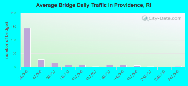
- 6,960,496Total average daily traffic
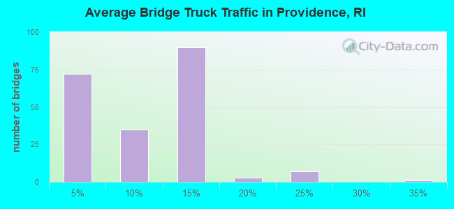
- 604,535Total average daily truck traffic
- National Bridge Inventory (NBI) Registered Bridges for Providence
- No street view available for this location
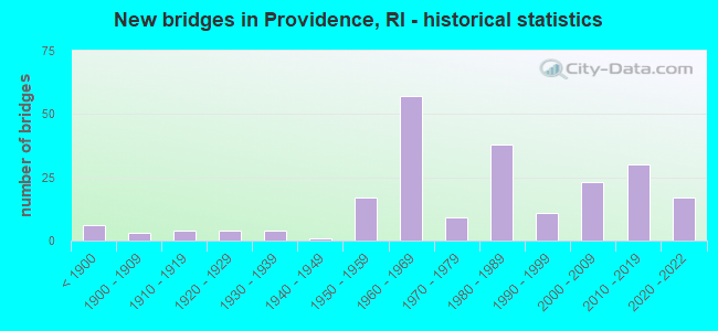
- New bridges - historical statistics
- 6Before 1900
- 31900-1909
- 41910-1919
- 41920-1929
- 41930-1939
- 11940-1949
- 171950-1959
- 571960-1969
- 91970-1979
- 381980-1989
- 111990-1999
- 232000-2009
- 302010-2019
- 172020-2022
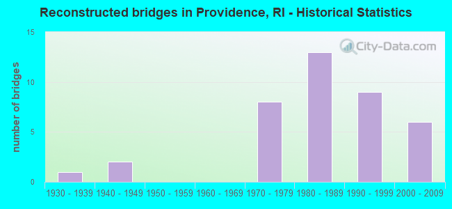
- Reconstructed bridges - Historical Statistics
- 11930-1939
- 21940-1949
- 01950-1959
- 01960-1969
- 81970-1979
- 131980-1989
- 91990-1999
- 62000-2009
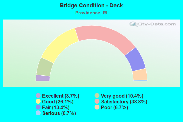
- Bridge Condition - Deck
- 3.7%Excellent
- 10.4%Very good
- 26.1%Good
- 38.8%Satisfactory
- 13.4%Fair
- 6.7%Poor
- 0.7%Serious
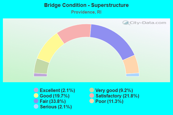
- Bridge Condition - Superstructure
- 2.1%Excellent
- 9.2%Very good
- 19.7%Good
- 21.8%Satisfactory
- 33.8%Fair
- 11.3%Poor
- 2.1%Serious
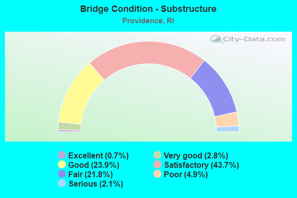
- Bridge Condition - Substructure
- 0.7%Excellent
- 2.8%Very good
- 23.9%Good
- 43.7%Satisfactory
- 21.8%Fair
- 4.9%Poor
- 2.1%Serious
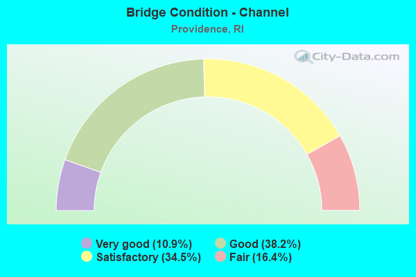
- Bridge Condition - Channel
- 10.9%Very good
- 38.2%Good
- 34.5%Satisfactory
- 16.4%Fair
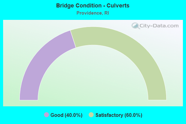
- Bridge Condition - Culverts
- 40.0%Good
- 60.0%Satisfactory
Find on map >> Show street view
Structure Number: 1076, Location: Rt 195 Providence (Lat: 41.813900, Lng: -71.407597), Route carried "under" structure: City street , Year Built: 2009, Structure Length: 0. m, Average Daily Traffic: 5,000 (year 2008), Truck Traffic: 10%, Features Intersected: Ramp WN,Ramp SE,Eddy St, Facility Carried by Structure: Ramp NP
Minimum Vertical Clearance: 6.64m (21.78ft), Kilometerpoint: 0.000, Lanes on structure: 1, Lanes under structure: 2, Material/Design: Steel, Design/Construction: Box Beam or Girders - Multiple, Length of Maximum Span: 51.8m (169.9ft)
Find on map >> Show street view
Structure Number: 1078, Location: 0.25 mi S of Clifford St (Lat: 41.814858, Lng: -71.412356), Route carried "under" structure: Ramp Interstate , Year Built: 2010, Structure Length: 0. m, Average Daily Traffic: 47,200 (year 2008), Truck Traffic: 8%, Features Intersected: Ramp SE & Ramp SES, Facility Carried by Structure: Ramp PS
Minimum Vertical Clearance: 5.16m (16.93ft), Kilometerpoint: 0.000, Lanes on structure: 2, Lanes under structure: 2, Material/Design: Steel, Design/Construction: Stringer/Multi-beam, Length of Maximum Span: 55.9m (183.4ft)
Find on map >> Show street view
Structure Number: 1078, Location: 0.25 mi S of Clifford St (Lat: 41.814858, Lng: -71.412356), Route carried "under" structure: Ramp Interstate , Year Built: 2010, Structure Length: 0. m, Average Daily Traffic: 15,000 (year 2008), Truck Traffic: 8%, Features Intersected: Ramp SE & Ramp SES, Facility Carried by Structure: Ramp PS
Minimum Vertical Clearance: 5.08m (16.67ft), Kilometerpoint: 0.000, Lanes on structure: 2, Lanes under structure: 1, Material/Design: Steel, Design/Construction: Stringer/Multi-beam, Length of Maximum Span: 55.9m (183.4ft)
Find on map >> Show street view
Structure Number: 1079, Location: Providence Exit 20 (Lat: 41.815100, Lng: -71.412342), Route carried "under" structure: Interstate 95, Year Built: 2006, Structure Length: 0. m, Average Daily Traffic: 182,250 (year 2008), Truck Traffic: 10%, Features Intersected: I-95 NB & SB, Facility Carried by Structure: Point Street
Minimum Vertical Clearance: 6.20m (20.34ft), Kilometerpoint: 0.000, Lanes on structure: 2, Lanes under structure: 11, Material/Design: Steel continuous, Design/Construction: Stringer/Multi-beam, Length of Maximum Span: 59.5m (195.2ft)
Find on map >> Show street view
Structure Number: 1079, Location: Providence Exit 20 (Lat: 41.815100, Lng: -71.412342), Route carried "under" structure: Ramp Interstate 95, Year Built: 2006, Structure Length: 0. m, Average Daily Traffic: 6,767 (year 2014), Truck Traffic: 5%, Features Intersected: I-95 NB & SB, Facility Carried by Structure: Point Street
Minimum Vertical Clearance: 5.98m (19.62ft), Kilometerpoint: 0.000, Lanes on structure: 2, Lanes under structure: 2, Material/Design: Steel continuous, Design/Construction: Stringer/Multi-beam, Length of Maximum Span: 59.5m (195.2ft)
Find on map >> Show street view
Structure Number: 108, Location: 0.25 mi N of Point St (Lat: 41.816208, Lng: -71.414519), Route carried "under" structure: Ramp US , Year Built: 2010, Structure Length: 0. m, Average Daily Traffic: 47,200 (year 2008), Truck Traffic: 5%, Features Intersected: Ramp SE,I-95,Ramp PN, Facility Carried by Structure: Clifford St
Minimum Vertical Clearance: 4.50m (14.76ft), Kilometerpoint: 0.000, Lanes on structure: 2, Lanes under structure: 2, Material/Design: Steel continuous, Design/Construction: Stringer/Multi-beam, Length of Maximum Span: 55.0m (180.4ft)
Find on map >> Show street view
Structure Number: 108, Location: 0.25 mi N of Point St (Lat: 41.816208, Lng: -71.414519), Route carried "under" structure: Interstate 95, Year Built: 2010, Structure Length: 0. m, Average Daily Traffic: 236,230 (year 1998), Truck Traffic: 10%, Features Intersected: Ramp SE,I-95,Ramp PN, Facility Carried by Structure: Clifford St
Minimum Vertical Clearance: 4.85m (15.91ft), Kilometerpoint: 0.000, Lanes on structure: 2, Lanes under structure: 8, Material/Design: Steel continuous, Design/Construction: Stringer/Multi-beam, Length of Maximum Span: 55.0m (180.4ft)
Find on map >> Show street view
Structure Number: 108, Location: 0.25 mi N of Point St (Lat: 41.816208, Lng: -71.414519), Route carried "under" structure: Ramp US , Year Built: 2010, Structure Length: 0. m, Average Daily Traffic: 5,000 (year 2008), Truck Traffic: 5%, Features Intersected: Ramp SE,I-95,Ramp PN, Facility Carried by Structure: Clifford St
Minimum Vertical Clearance: 5.28m (17.32ft), Kilometerpoint: 0.000, Lanes on structure: 2, Lanes under structure: 1, Material/Design: Steel continuous, Design/Construction: Stringer/Multi-beam, Length of Maximum Span: 55.0m (180.4ft)
Find on map >> Show street view
Structure Number: 1083, Location: .5 mi E of Jct of I 95 (Lat: 41.817736, Lng: -71.396847), Route carried "under" structure: Ramp Interstate 195, Year Built: 2009, Structure Length: 0. m, Average Daily Traffic: 17,500 (year 2010), Truck Traffic: 5%, Features Intersected: I-195 Ramp SME
Minimum Vertical Clearance: 4.95m (16.24ft), Kilometerpoint: 0.000, Lanes on structure: 1, Lanes under structure: 2, Material/Design: Prestressed concrete, Design/Construction: Box Beam or Girders - Multiple, Length of Maximum Span: 12.4m (40.7ft)
Find on map >> Show street view
Structure Number: 1304, Location: RI 10 NB to US 6 WB Ramp (Lat: 41.813742, Lng: -71.440853), Route carried "under" structure: State highway 10, Year Built: 2021, Structure Length: 0. m, Features Intersected: WESTMSTER,TROY,AMTRAK,10
Minimum Vertical Clearance: 15.24m (50.00ft), Kilometerpoint: 0.000, Lanes on structure: 1, Lanes under structure: 2, Material/Design: Steel continuous, Design/Construction: Mixed types, Length of Maximum Span: 77.1m (253.0ft)
Find on map >> Show street view
Structure Number: 1304, Location: RI 10 NB to US 6 WB Ramp (Lat: 41.813742, Lng: -71.440853), Route carried "under" structure: ServiceCity street , Year Built: 2021, Structure Length: 0. m, Features Intersected: WESTMSTER,TROY,AMTRAK,10, Facility Carried by Structure: Route10NB to 6 WB
Minimum Vertical Clearance: 15.24m (50.00ft), Kilometerpoint: 0.000, Lanes on structure: 1, Lanes under structure: 1, Material/Design: Steel continuous, Design/Construction: Mixed types, Length of Maximum Span: 77.1m (253.0ft)
Find on map >> Show street view
Structure Number: 1304, Location: RI 10 NB to US 6 WB Ramp (Lat: 41.813742, Lng: -71.440853), Route carried "under" structure: Ramp State highway 6, Year Built: 2021, Structure Length: 0. m, Average Daily Traffic: 35,970 (year 2020), Truck Traffic: 4%, Features Intersected: WESTMSTER,TROY,AMTRAK,10
Minimum Vertical Clearance: 6.16m (20.21ft), Kilometerpoint: 0.000, Lanes on structure: 1, Lanes under structure: 2, Material/Design: Steel continuous, Design/Construction: Mixed types, Length of Maximum Span: 77.1m (253.0ft)
Find on map >> Show street view
Structure Number: 1304, Location: RI 10 NB to US 6 WB Ramp (Lat: 41.813742, Lng: -71.440853), Route carried "under" structure: Ramp State highway 6, Year Built: 2021, Structure Length: 0. m, Average Daily Traffic: 40,760 (year 2020), Truck Traffic: 4%, Features Intersected: WESTMSTER,TROY,AMTRAK,10
Minimum Vertical Clearance: 6.26m (20.54ft), Kilometerpoint: 0.000, Lanes on structure: 1, Lanes under structure: 2, Material/Design: Steel continuous, Design/Construction: Mixed types, Length of Maximum Span: 77.1m (253.0ft)
Find on map >> Show street view
Structure Number: 1304, Location: RI 10 NB to US 6 WB Ramp (Lat: 41.813742, Lng: -71.440853), Route carried "under" structure: City street , Year Built: 2021, Structure Length: 0. m, Features Intersected: WESTMSTER,TROY,AMTRAK,10, Facility Carried by Structure: Route10NB to 6 WB
Minimum Vertical Clearance: 12.19m (39.99ft), Kilometerpoint: 0.000, Lanes on structure: 1, Lanes under structure: 2, Material/Design: Steel continuous, Design/Construction: Mixed types, Length of Maximum Span: 77.1m (253.0ft)
Find on map >> Show street view
Structure Number: 1306, Location: 1.4 Mi W of JCT I-95 (Lat: 41.815883, Lng: -71.438906), Route carried "under" structure: US 6, Year Built: 2020, Structure Length: 0. m, Average Daily Traffic: 7,000 (year 2008), Truck Traffic: 10%, Features Intersected: 10 NB & SB , EB & WB, Facility Carried by Structure: WESTMINSTER ST
Minimum Vertical Clearance: 4.57m (14.99ft), Kilometerpoint: 0.000, Lanes on structure: 4, Lanes under structure: 2, Material/Design: Steel, Design/Construction: Stringer/Multi-beam, Length of Maximum Span: 36.6m (120.1ft)
Find on map >> Show street view
Structure Number: 1308, Location: 0.3 Mi N of JCT RI 195 (Lat: 41.817644, Lng: -71.438508), Route carried "under" structure: US 6, Year Built: 2020, Structure Length: 0. m, Average Daily Traffic: 12,570 (year 2018), Truck Traffic: 5%, Features Intersected: 6 EB&WB10NB&SB,SRD, Facility Carried by Structure: BROADWAY
Minimum Vertical Clearance: 30+ m (98+ ft), Kilometerpoint: 0.000, Lanes on structure: 2, Lanes under structure: 4, Material/Design: Steel, Design/Construction: Stringer/Multi-beam, Length of Maximum Span: 37.6m (123.4ft)