Bridge Statistics for Providence, Rhode Island (RI)
Condition, Traffic, Stress, Structural Evaluation, Project Costs
- National Bridge Inventory (NBI) Statistics
- 224Number of bridges
- 3,862ft / 1,177mTotal length
- $846,417,000Total costs
- 6,960,496Total average daily traffic
- 604,535Total average daily truck traffic
- National Bridge Inventory (NBI) Registered Bridges for Providence
- No street view available for this location
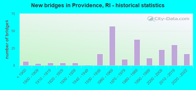
- New bridges - historical statistics
- 6Before 1900
- 31900-1909
- 41910-1919
- 41920-1929
- 41930-1939
- 11940-1949
- 171950-1959
- 571960-1969
- 91970-1979
- 381980-1989
- 111990-1999
- 232000-2009
- 302010-2019
- 172020-2022
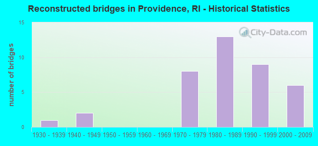
- Reconstructed bridges - Historical Statistics
- 11930-1939
- 21940-1949
- 01950-1959
- 01960-1969
- 81970-1979
- 131980-1989
- 91990-1999
- 62000-2009
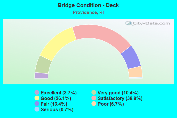
- Bridge Condition - Deck
- 3.7%Excellent
- 10.4%Very good
- 26.1%Good
- 38.8%Satisfactory
- 13.4%Fair
- 6.7%Poor
- 0.7%Serious
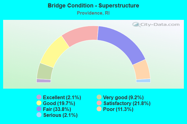
- Bridge Condition - Superstructure
- 2.1%Excellent
- 9.2%Very good
- 19.7%Good
- 21.8%Satisfactory
- 33.8%Fair
- 11.3%Poor
- 2.1%Serious
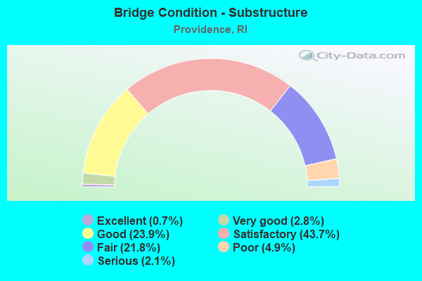
- Bridge Condition - Substructure
- 0.7%Excellent
- 2.8%Very good
- 23.9%Good
- 43.7%Satisfactory
- 21.8%Fair
- 4.9%Poor
- 2.1%Serious
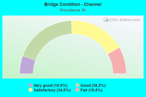
- Bridge Condition - Channel
- 10.9%Very good
- 38.2%Good
- 34.5%Satisfactory
- 16.4%Fair
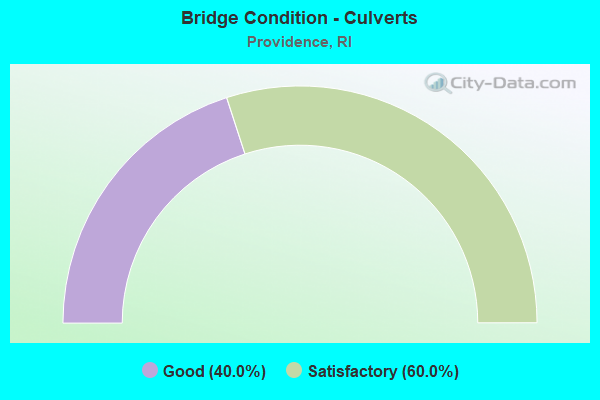
- Bridge Condition - Culverts
- 40.0%Good
- 60.0%Satisfactory
Find on map >> Show street view
Structure Number: 1076, Location: Rt 195 Providence (Lat: 41.813900, Lng: -71.407597), Route carried "on" structure: Ramp US 95, Year Built: 2009, Status: Open, Structure Length: 29.37m (96.36ft), Average Daily Traffic: 11,340 (year 2008), Truck Traffic: 10%, Average Future Daily Traffic: 13,608 (year 2036), Design Load: HS 25 or greater, Features Intersected: Ramp WN,Ramp SE,Eddy St, Facility Carried by Structure: Ramp NP
Minimum Vertical Clearance: 5.23m (17.16ft), Kilometerpoint: 0.451, Lanes on structure: 1, Lanes under structure: 6, Owner: State Highway Agency, Approaching Roadway Width: 9.1m (29.9ft), Material/Design: Steel, Design/Construction: Box Beam or Girders - Multiple, Number Of Spans In Main Unit: 7, Length of Maximum Span: 51.8m (169.9ft), Curb-To-Curb Width: 9.1m (29.9ft), Out-to-Out Width: 9.8m (32.2ft)
Condition: Deck: Satisfactory, Superstructure: Good, Substructure: Good, Operating Rating: 31.8 metric tons, Method Used To Determine Operating Rating: Load and Resistance Factor Rating (LRFR) rating reported by rating factor(RF) method using HL-93 loadings, Inventory Rating: 21.7 metric tons, Method Used To Determine Inventory Rating: Load and Resistance Factor Rating (LRFR) rating reported by rating factor(RF) method using HL-93 loadings, Structural Evaluation: Somewhat better than minimum adequacy, Deck Geometry: Better than present minimum criteria, Underclear: High priority of corrective action, Approach Roadway Alignment: Better than present minimum criteria, Designated Inspection Frequency: Every 24 months, Critical Feature Inspection Frequency: Every 12 months, Inspection Date: May 2021, Critical Feature Inspection Date: May 2021, Deck Structure Type: Concrete Cast-file-Place, Wearing Surface/Protective System: Wearing Surface: Monolithic Concrete, Deck Protection: Epoxy Coated Reinforcing
Find on map >> Show street view
Structure Number: 1077, Location: Rt 195 Providence (Lat: 41.814492, Lng: -71.408697), Route carried "on" structure: Ramp City street , Year Built: 2009, Status: Open, Structure Length: 11.43m (37.50ft), Average Daily Traffic: 8,770 (year 2008), Truck Traffic: 10%, Average Future Daily Traffic: 10,524 (year 2036), Design Load: HS 25 or greater, Features Intersected: Globe St & Hospital St, Facility Carried by Structure: Ramp WP
Minimum Vertical Clearance: 6.01m (19.72ft), Kilometerpoint: 0.375, Lanes on structure: 1, Lanes under structure: 2, Owner: State Highway Agency, Approaching Roadway Width: 7.9m (25.9ft), Material/Design: Steel continuous, Design/Construction: Box Beam or Girders - Multiple, Number Of Spans In Main Unit: 3, Length of Maximum Span: 45.1m (148.0ft), Curb-To-Curb Width: 7.9m (25.9ft), Out-to-Out Width: 9.1m (29.9ft)
Condition: Deck: Satisfactory, Superstructure: Good, Substructure: Good, Operating Rating: 36.3 metric tons, Method Used To Determine Operating Rating: Load and Resistance Factor Rating (LRFR) rating reported by rating factor(RF) method using HL-93 loadings, Inventory Rating: 20.7 metric tons, Method Used To Determine Inventory Rating: Load and Resistance Factor Rating (LRFR) rating reported by rating factor(RF) method using HL-93 loadings, Structural Evaluation: Somewhat better than minimum adequacy, Deck Geometry: Equal to present desirable criteria, Underclear: Superior to present desirable criteria, Approach Roadway Alignment: Better than present minimum criteria, Designated Inspection Frequency: Every 24 months, Critical Feature Inspection Frequency: Every 12 months, Inspection Date: May 2021, Critical Feature Inspection Date: May 2021, Deck Structure Type: Concrete Cast-file-Place, Wearing Surface/Protective System: Wearing Surface: Monolithic Concrete, Deck Protection: Epoxy Coated Reinforcing
Find on map >> Show street view
Structure Number: 1078, Location: 0.25 mi S of Clifford St (Lat: 41.814858, Lng: -71.412356), Route carried "on" structure: Ramp Interstate , Year Built: 2010, Status: Open, Structure Length: 15.96m (52.36ft), Average Daily Traffic: 7,800 (year 2008), Truck Traffic: 8%, Average Future Daily Traffic: 9,360 (year 2036), Design Load: HS 25 or greater, Features Intersected: Ramp SE & Ramp SES, Facility Carried by Structure: Ramp PS
Minimum Vertical Clearance: 30+ m (98+ ft), Kilometerpoint: 0.121, Lanes on structure: 2, Lanes under structure: 3, Owner: State Highway Agency, Approaching Roadway Width: 8.5m (27.9ft), Material/Design: Steel, Design/Construction: Stringer/Multi-beam, Number Of Spans In Main Unit: 3, Length of Maximum Span: 55.9m (183.4ft), Curb-To-Curb Width: 8.5m (27.9ft), Out-to-Out Width: 9.5m (31.2ft)
Condition: Deck: Good, Superstructure: Good, Substructure: Good, Operating Rating: 35.3 metric tons, Method Used To Determine Operating Rating: Load and Resistance Factor Rating (LRFR) rating reported by rating factor(RF) method using HL-93 loadings, Inventory Rating: 27.2 metric tons, Method Used To Determine Inventory Rating: Load and Resistance Factor Rating (LRFR) rating reported by rating factor(RF) method using HL-93 loadings, Structural Evaluation: Equal to present minimum criteria, Deck Geometry: High priority of corrective action, Underclear: High priority of corrective action, Approach Roadway Alignment: Better than present minimum criteria, Designated Inspection Frequency: Every 24 months, Inspection Date: December 2021, Deck Structure Type: Concrete Cast-file-Place, Wearing Surface/Protective System: Wearing Surface: Monolithic Concrete, Deck Protection: Epoxy Coated Reinforcing
Find on map >> Show street view
Structure Number: 1079, Location: Providence Exit 20 (Lat: 41.815100, Lng: -71.412342), Route carried "on" structure: City street , Year Built: 2006, Status: Open, Structure Length: 16.43m (53.90ft), Average Daily Traffic: 6,767 (year 2014), Truck Traffic: 5%, Average Future Daily Traffic: 8,121 (year 2036), Design Load: HS 25 or greater, Features Intersected: I-95 NB & SB, Facility Carried by Structure: Point Street
Minimum Vertical Clearance: 30+ m (98+ ft), Kilometerpoint: 0.383, Lanes on structure: 2, Lanes under structure: 13, Base Highway Network: Yes, Owner: State Highway Agency, Approaching Roadway Width: 11.0m (36.1ft), Skew: 15 degrees, Material/Design: Steel continuous, Design/Construction: Stringer/Multi-beam, Number Of Spans In Main Unit: 3, Length of Maximum Span: 59.5m (195.2ft), Curb or Sidewalk Widths: Left: 2.4m (7.9ft), Right: 0.0m, Curb-To-Curb Width: 11.0m (36.1ft), Out-to-Out Width: 13.6m (44.6ft)
Condition: Deck: Satisfactory, Superstructure: Good, Substructure: Good, Operating Rating: 43.1 metric tons, Method Used To Determine Operating Rating: Load and Resistance Factor Rating (LRFR) rating reported by rating factor(RF) method using HL-93 loadings, Inventory Rating: 33.4 metric tons, Method Used To Determine Inventory Rating: Load and Resistance Factor Rating (LRFR) rating reported by rating factor(RF) method using HL-93 loadings, Structural Evaluation: Better than present minimum criteria, Deck Geometry: Equal to present minimum criteria, Underclear: High priority of corrective action, Approach Roadway Alignment: Better than present minimum criteria, Designated Inspection Frequency: Every 24 months, Inspection Date: December 2021, Deck Structure Type: Concrete Cast-file-Place, Wearing Surface/Protective System: Wearing Surface: Monolithic Concrete, Deck Protection: Epoxy Coated Reinforcing
Find on map >> Show street view
Structure Number: 108, Location: 0.25 mi N of Point St (Lat: 41.816208, Lng: -71.414519), Route carried "on" structure: Ramp City street , Year Built: 2010, Status: Open, Structure Length: 11.21m (36.78ft), Average Daily Traffic: 5,000 (year 2008), Truck Traffic: 5%, Average Future Daily Traffic: 6,000 (year 2036), Design Load: HS 25 or greater, Features Intersected: Ramp SE,I-95,Ramp PN, Facility Carried by Structure: Clifford St
Minimum Vertical Clearance: 30+ m (98+ ft), Kilometerpoint: 0.624, Lanes on structure: 2, Lanes under structure: 11, Owner: State Highway Agency, Approaching Roadway Width: 8.5m (27.9ft), Skew: 2 degrees, Material/Design: Steel continuous, Design/Construction: Stringer/Multi-beam, Number Of Spans In Main Unit: 2, Length of Maximum Span: 55.0m (180.4ft), Curb or Sidewalk Widths: Left: 3.0m (9.8ft), Right: 3.0m (9.8ft), Curb-To-Curb Width: 8.5m (27.9ft), Out-to-Out Width: 14.6m (47.9ft)
Condition: Deck: Satisfactory, Superstructure: Good, Substructure: Good, Operating Rating: 60.6 metric tons, Method Used To Determine Operating Rating: Load and Resistance Factor Rating (LRFR) rating reported by rating factor(RF) method using HL-93 loadings, Inventory Rating: 46.7 metric tons, Method Used To Determine Inventory Rating: Load and Resistance Factor Rating (LRFR) rating reported by rating factor(RF) method using HL-93 loadings, Structural Evaluation: Better than present minimum criteria, Deck Geometry: High priority of corrective action, Underclear: High priority of corrective action, Approach Roadway Alignment: Better than present minimum criteria, Designated Inspection Frequency: Every 24 months, Inspection Date: December 2021, Deck Structure Type: Concrete Cast-file-Place, Wearing Surface/Protective System: Wearing Surface: Monolithic Concrete, Deck Protection: Epoxy Coated Reinforcing
Find on map >> Show street view
Structure Number: 1081, Location: Providence exit 1 (Lat: 41.815347, Lng: -71.401844), Route carried "on" structure: Interstate 195, Year Built: 2007, Status: Open, Structure Length: 37.65m (123.52ft), Average Daily Traffic: 167,300 (year 2021), Truck Traffic: 10%, Average Future Daily Traffic: 184,030 (year 2041), Design Load: HS 25 or greater, Features Intersected: ProvRiver,SoMain&SoWater
Minimum Vertical Clearance: 8.47m (27.79ft), Kilometerpoint: 0.978, Lanes on structure: 8, Lanes under structure: 4, Base Highway Network: Yes, Owner: State Highway Agency, Approaching Roadway Width: 43.9m (144.0ft), Skew: 11 degrees, Navigation Control: Yes ( Vertical Clearance: 10.8m (35.4ft), Horizontal Clearance: 109.1m (357.9ft)), Material/Design: Steel, Design/Construction: Arch - Thru, Number Of Spans In Main Unit: 1, Number Of Approach Spans: 6, Length of Maximum Span: 121.9m (399.9ft), Curb-To-Curb Width: 43.9m (144.0ft), Out-to-Out Width: 50.9m (167.0ft)
Condition: Deck: Good, Superstructure: Good, Substructure: Good, Channel: Good, Operating Rating: 55.1 metric tons, Method Used To Determine Operating Rating: Load and Resistance Factor Rating (LRFR) rating reported by rating factor(RF) method using HL-93 loadings, Inventory Rating: 42.4 metric tons, Method Used To Determine Inventory Rating: Load and Resistance Factor Rating (LRFR) rating reported by rating factor(RF) method using HL-93 loadings, Structural Evaluation: Better than present minimum criteria, Deck Geometry: Superior to present desirable criteria, Waterway Adequacy: Better than present minimum criteria, Approach Roadway Alignment: Equal to present desirable criteria, Designated Inspection Frequency: Every 24 months, Underwater Inspection Frequency: Every 48 months, Inspection Date: August 2021, Underwater Inspection Date: August 2021, Deck Structure Type: Concrete Cast-file-Place, Wearing Surface/Protective System: Wearing Surface: Monolithic Concrete, Deck Protection: Epoxy Coated Reinforcing
Find on map >> Show street view
Structure Number: 1082, Location: 0.5 m east of I-95 (Lat: 41.817136, Lng: -71.398725), Route carried "on" structure: Interstate 195, Year Built: 2008, Status: Open, Structure Length: 1.49m (4.89ft), Average Daily Traffic: 167,300 (year 2021), Truck Traffic: 10%, Average Future Daily Traffic: 184,030 (year 2041), Design Load: HS 25 or greater, Features Intersected: South Main Street
Minimum Vertical Clearance: 30+ m (98+ ft), Kilometerpoint: 1.262, Lanes on structure: 9, Lanes under structure: 2, Base Highway Network: Yes, Owner: State Highway Agency, Approaching Roadway Width: 46.3m (151.9ft), Skew: 10 degrees, Material/Design: Prestressed concrete, Design/Construction: Box Beam or Girders - Multiple, Number Of Spans In Main Unit: 1, Length of Maximum Span: 13.4m (44.0ft), Curb-To-Curb Width: 46.3m (151.9ft), Out-to-Out Width: 48.8m (160.1ft)
Condition: Deck: Good, Superstructure: Satisfactory, Substructure: Satisfactory, Operating Rating: 37.9 metric tons, Method Used To Determine Operating Rating: Load and Resistance Factor Rating (LRFR) rating reported by rating factor(RF) method using HL-93 loadings, Inventory Rating: 29.8 metric tons, Method Used To Determine Inventory Rating: Load and Resistance Factor Rating (LRFR) rating reported by rating factor(RF) method using HL-93 loadings, Structural Evaluation: Equal to present minimum criteria, Deck Geometry: Superior to present desirable criteria, Underclear: High priority of corrective action, Approach Roadway Alignment: Equal to present desirable criteria, Designated Inspection Frequency: Every 24 months, Inspection Date: December 2021, Deck Structure Type: Concrete Cast-file-Place, Wearing Surface/Protective System: Wearing Surface: Integral Concrete, Deck Protection: Epoxy Coated Reinforcing
Find on map >> Show street view
Structure Number: 1083, Location: .5 mi E of Jct of I 95 (Lat: 41.817736, Lng: -71.396847), Route carried "on" structure: Ramp City street 195, Year Built: 2009, Status: Open, Structure Length: 1.35m (4.43ft), Average Daily Traffic: 7,400 (year 2010), Truck Traffic: 5%, Average Future Daily Traffic: 8,880 (year 2036), Design Load: HS 25 or greater, Features Intersected: I-195 Ramp SME
Minimum Vertical Clearance: 30+ m (98+ ft), Kilometerpoint: 0.095, Lanes on structure: 1, Lanes under structure: 2, Owner: State Highway Agency, Approaching Roadway Width: 7.9m (25.9ft), Material/Design: Prestressed concrete, Design/Construction: Box Beam or Girders - Multiple, Number Of Spans In Main Unit: 1, Length of Maximum Span: 12.4m (40.7ft), Curb-To-Curb Width: 7.9m (25.9ft), Out-to-Out Width: 101.2m (332.0ft)
Condition: Deck: Satisfactory, Superstructure: Fair, Substructure: Satisfactory, Operating Rating: 58.3 metric tons, Method Used To Determine Operating Rating: Load and Resistance Factor Rating (LRFR) rating reported by rating factor(RF) method using HL-93 loadings, Inventory Rating: 45.0 metric tons, Method Used To Determine Inventory Rating: Load and Resistance Factor Rating (LRFR) rating reported by rating factor(RF) method using HL-93 loadings, Structural Evaluation: Somewhat better than minimum adequacy, Deck Geometry: Equal to present desirable criteria, Underclear: Somewhat better than minimum adequacy, Approach Roadway Alignment: Better than present minimum criteria, Designated Inspection Frequency: Every 24 months, Inspection Date: December 2021, Deck Structure Type: Concrete Cast-file-Place, Wearing Surface/Protective System: Wearing Surface: Monolithic Concrete, Deck Protection: Epoxy Coated Reinforcing
Find on map >> Show street view
Structure Number: 1097, Location: .01Mile West of GANO ST (Lat: 41.818039, Lng: -71.391619), Route carried "on" structure: City street , Year Built: 2008, Status: Open, Structure Length: 0.82m (2.69ft), Average Daily Traffic: 199 (year 2021), Truck Traffic: 14%, Average Future Daily Traffic: 219 (year 2041), Design Load: HS 20, Features Intersected: India Pt Bike Path, Facility Carried by Structure: India Street
Minimum Vertical Clearance: 30+ m (98+ ft), Kilometerpoint: 0.805, Lanes on structure: 2, Owner: State Highway Agency, Approaching Roadway Width: 11.9m (39.0ft), Material/Design: Concrete, Design/Construction: Frame, Number Of Spans In Main Unit: 1, Length of Maximum Span: 5.8m (19.0ft), Curb or Sidewalk Widths: Left: 2.1m (6.9ft), Right: 2.1m (6.9ft), Curb-To-Curb Width: 11.0m (36.1ft), Out-to-Out Width: 16.2m (53.1ft)
Condition: Deck: Good, Superstructure: Good, Substructure: Good, Operating Rating: 44.5 metric tons, Method Used To Determine Operating Rating: Load and Resistance Factor (LRFR), Inventory Rating: 33.6 metric tons, Method Used To Determine Inventory Rating: Load and Resistance Factor (LRFR), Structural Evaluation: Better than present minimum criteria, Deck Geometry: Equal to present desirable criteria, Approach Roadway Alignment: Better than present minimum criteria, Designated Inspection Frequency: Every 24 months, Inspection Date: October 2020, Wearing Surface/Protective System: Wearing Surface: Bituminous, Membrane: Preformed Fabric, Deck Protection: Epoxy Coated Reinforcing
Find on map >> Show street view
Structure Number: 1304, Location: RI 10 NB to US 6 WB Ramp (Lat: 41.813742, Lng: -71.440853), Route carried "on" structure: State highway 10, Year Built: 2021, Status: Open, Structure Length: 28.82m (94.55ft), Average Daily Traffic: 15,370 (year 2021), Truck Traffic: 5%, Average Future Daily Traffic: 16,160 (year 2041), Design Load: Greater than HL93, Features Intersected: WESTMSTER,TROY,AMTRAK,10
Minimum Vertical Clearance: 30.18m (99.02ft), Kilometerpoint: 0.000, Lanes on structure: 1, Lanes under structure: 9, Owner: State Highway Agency, Approaching Roadway Width: 7.9m (25.9ft), Material/Design: Steel continuous, Design/Construction: Mixed types, Number Of Spans In Main Unit: 6, Length of Maximum Span: 77.1m (253.0ft), Curb-To-Curb Width: 7.9m (25.9ft), Out-to-Out Width: 9.0m (29.5ft)
Condition: Deck: Very good, Superstructure: Very good, Substructure: Good, Operating Rating: 45.4 metric tons, Method Used To Determine Operating Rating: Load and Resistance Factor Rating (LRFR) rating reported by rating factor(RF) method using HL-93 loadings, Inventory Rating: 35.0 metric tons, Method Used To Determine Inventory Rating: Load and Resistance Factor Rating (LRFR) rating reported by rating factor(RF) method using HL-93 loadings, Structural Evaluation: Better than present minimum criteria, Deck Geometry: High priority of corrective action, Underclear: Equal to present minimum criteria, Approach Roadway Alignment: Equal to present desirable criteria, Designated Inspection Frequency: Every 24 months, Critical Feature Inspection Frequency: Every 12 months, Inspection Date: November 2021, Critical Feature Inspection Date: November 2021, Deck Structure Type: Concrete Cast-file-Place, Wearing Surface/Protective System: Wearing Surface: Bituminous, Membrane: Other, Deck Protection: Galvanized Reinforcing
Find on map >> Show street view
Structure Number: 1306, Location: 1.4 Mi W of JCT I-95 (Lat: 41.815883, Lng: -71.438906), Route carried "on" structure: Alternate City street , Year Built: 2020, Status: Open, Structure Length: 6.80m (22.31ft), Average Daily Traffic: 19,490 (year 2018), Truck Traffic: 13%, Average Future Daily Traffic: 20,490 (year 2040), Design Load: Greater than HL93, Features Intersected: 10 NB & SB , EB & WB, Facility Carried by Structure: WESTMINSTER ST
Minimum Vertical Clearance: 30+ m (98+ ft), Kilometerpoint: 1.820, Lanes on structure: 4, Lanes under structure: 5, Owner: State Highway Agency, Approaching Roadway Width: 14.6m (47.9ft), Skew: 1 degrees, Material/Design: Steel, Design/Construction: Stringer/Multi-beam, Number Of Spans In Main Unit: 2, Length of Maximum Span: 36.6m (120.1ft), Curb or Sidewalk Widths: Left: 2.4m (7.9ft), Right: 0.0m, Curb-To-Curb Width: 8.0m (26.2ft), Out-to-Out Width: 13.2m (43.3ft)
Condition: Deck: Very good, Superstructure: Very good, Substructure: Good, Operating Rating: 43.1 metric tons, Method Used To Determine Operating Rating: Load and Resistance Factor Rating (LRFR) rating reported by rating factor(RF) method using HL-93 loadings, Inventory Rating: 33.4 metric tons, Method Used To Determine Inventory Rating: Load and Resistance Factor Rating (LRFR) rating reported by rating factor(RF) method using HL-93 loadings, Structural Evaluation: Better than present minimum criteria, Deck Geometry: High priority of replacement, Underclear: Better than present minimum criteria, Approach Roadway Alignment: Equal to present desirable criteria, Length Of Structure Improvement: 1.46m (4.79ft), Designated Inspection Frequency: Every 24 months, Inspection Date: November 2020, Bridge Improvement Cost: $227,000, Roadway Improvement Cost: $23,000, Total Project Cost: $341,000, Deck Structure Type: Concrete Cast-file-Place, Wearing Surface/Protective System: Wearing Surface: Bituminous, Membrane: Preformed Fabric, Deck Protection: Galvanized Reinforcing
Find on map >> Show street view
Structure Number: 1308, Location: 0.3 Mi N of JCT RI 195 (Lat: 41.817644, Lng: -71.438508), Route carried "on" structure: City street , Year Built: 2020, Status: Open, Structure Length: 5.90m (19.36ft), Average Daily Traffic: 10,000 (year 2008), Truck Traffic: 5%, Average Future Daily Traffic: 12,000 (year 2036), Design Load: HL 93, Features Intersected: 6 EB&WB10NB&SB,SRD, Facility Carried by Structure: BROADWAY
Minimum Vertical Clearance: 4.42m (14.50ft), Kilometerpoint: 1.635, Lanes on structure: 2, Lanes under structure: 4, Owner: State Highway Agency, Approaching Roadway Width: 10.8m (35.4ft), Skew: 5 degrees, Material/Design: Steel, Design/Construction: Stringer/Multi-beam, Number Of Spans In Main Unit: 2, Length of Maximum Span: 37.6m (123.4ft), Curb or Sidewalk Widths: Left: 2.7m (8.9ft), Right: 2.7m (8.9ft), Curb-To-Curb Width: 10.8m (35.4ft), Out-to-Out Width: 24.4m (80.1ft)
Condition: Deck: Very good, Superstructure: Good, Substructure: Good, Operating Rating: 57.7 metric tons, Method Used To Determine Operating Rating: Load and Resistance Factor Rating (LRFR) rating reported by rating factor(RF) method using HL-93 loadings, Inventory Rating: 44.4 metric tons, Method Used To Determine Inventory Rating: Load and Resistance Factor Rating (LRFR) rating reported by rating factor(RF) method using HL-93 loadings, Structural Evaluation: Better than present minimum criteria, Deck Geometry: Meets minimum limits, Underclear: High priority of corrective action, Approach Roadway Alignment: Equal to present desirable criteria, Length Of Structure Improvement: 3.78m (12.40ft), Designated Inspection Frequency: Every 24 months, Inspection Date: September 2020, Bridge Improvement Cost: $530,000, Roadway Improvement Cost: $53,000, Total Project Cost: $795,000, Deck Structure Type: Concrete Cast-file-Place, Wearing Surface/Protective System: Wearing Surface: Bituminous, Membrane: Preformed Fabric, Deck Protection: Galvanized Reinforcing
Find on map >> Show street view
Structure Number: 428, Location: 2.0 Mi N of JCT I-95 (Lat: 41.853072, Lng: -71.426561), Route carried "under" structure: City street , Year Built: 1957, Structure Length: 0. m, Average Daily Traffic: 65,800 (year 2021), Truck Traffic: 21%, Features Intersected: BRANCH AV, Facility Carried by Structure: RI 146 ED DOWL HWY
Minimum Vertical Clearance: 4.50m (14.76ft), Kilometerpoint: 0.000, Lanes on structure: 4, Lanes under structure: 4, Material/Design: Steel, Design/Construction: Stringer/Multi-beam, Length of Maximum Span: 19.8m (65.0ft)
Find on map >> Show street view
Structure Number: 429, Location: 2.5 Mi N of JCT I-95 (Lat: 41.849839, Lng: -71.424394), Route carried "under" structure: Alternate State highway 146, Year Built: 1957, Structure Length: 0. m, Average Daily Traffic: 5,000 (year 2008), Truck Traffic: 10%, Features Intersected: RI 146 LOUISQUISSET PIKE, Facility Carried by Structure: HAWKINS ST
Minimum Vertical Clearance: 4.38m (14.37ft), Kilometerpoint: 0.000, Lanes on structure: 2, Lanes under structure: 4, Material/Design: Steel, Design/Construction: Stringer/Multi-beam, Length of Maximum Span: 15.5m (50.9ft)
Find on map >> Show street view
Structure Number: 43, Location: 1.0 Mi N of JCT I-95 (Lat: 41.840694, Lng: -71.417900), Route carried "under" structure: State highway 146, Year Built: 1975, Structure Length: 0. m, Average Daily Traffic: 20,250 (year 2021), Features Intersected: RI 146 LOUISQUISSET PIKE, Facility Carried by Structure: ADMIRAL ST
Minimum Vertical Clearance: 4.27m (14.01ft), Kilometerpoint: 0.000, Lanes on structure: 4, Lanes under structure: 4, Material/Design: Steel, Design/Construction: Stringer/Multi-beam, Length of Maximum Span: 15.8m (51.8ft)
Find on map >> Show street view
Structure Number: 454, Location: 40' W of JCT Niantc A (Lat: 41.788789, Lng: -71.436083), Route carried "under" structure: State highway 10, Year Built: 1959, Structure Length: 0. m, Average Daily Traffic: 47,200 (year 2008), Truck Traffic: 10%, Features Intersected: RI 10 HUNTINGTON EXPRESS, Facility Carried by Structure: FRANKFORT STREET
Minimum Vertical Clearance: 4.32m (14.17ft), Kilometerpoint: 0.000, Lanes on structure: 2, Lanes under structure: 5, Material/Design: Prestressed concrete, Design/Construction: Box Beam or Girders - Multiple, Length of Maximum Span: 20.4m (66.9ft)
Find on map >> Show street view
Structure Number: 507, Location: 0.3 Mi N of JCT RI 195 (Lat: 41.817500, Lng: -71.439000), Route carried "under" structure: City street , Year Built: 1951, Structure Length: 0. m, Average Daily Traffic: 10,000 (year 2008), Truck Traffic: 10%, Features Intersected: BROADWAY, Facility Carried by Structure: US 6 OLNEYVLLE EXP
Minimum Vertical Clearance: 4.37m (14.34ft), Kilometerpoint: 0.000, Lanes on structure: 3, Lanes under structure: 2, Material/Design: Steel, Design/Construction: Stringer/Multi-beam, Length of Maximum Span: 18.6m (61.0ft)
Find on map >> Show street view
Structure Number: 571, Location: 1.0 Mi N of JCT Elmwd Av (Lat: 41.817642, Lng: -71.416628), Route carried "under" structure: Interstate 95, Year Built: 1963, Structure Length: 0. m, Average Daily Traffic: 100,000 (year 2008), Truck Traffic: 10%, Features Intersected: I-95, A,B,C,D, Facility Carried by Structure: BROAD ST
Minimum Vertical Clearance: 4.42m (14.50ft), Kilometerpoint: 0.000, Lanes on structure: 4, Lanes under structure: 9, Material/Design: Steel, Design/Construction: Stringer/Multi-beam, Length of Maximum Span: 29.9m (98.1ft)
Find on map >> Show street view
Structure Number: 572, Location: 0.1 Mi N of JCT I-195 (Lat: 41.819014, Lng: -71.418361), Route carried "under" structure: Interstate 95, Year Built: 1963, Structure Length: 0. m, Average Daily Traffic: 89,000 (year 2008), Truck Traffic: 10%, Features Intersected: I-95 NB & SB, Facility Carried by Structure: WESTMINSTER ST
Minimum Vertical Clearance: 4.32m (14.17ft), Kilometerpoint: 0.000, Lanes on structure: 3, Lanes under structure: 9, Material/Design: Steel, Design/Construction: Stringer/Multi-beam, Length of Maximum Span: 27.4m (89.9ft)
Find on map >> Show street view
Structure Number: 573, Location: 0.3 Mi N of JCT I-195 (Lat: 41.819911, Lng: -71.419350), Route carried "under" structure: Interstate 95, Year Built: 1963, Structure Length: 0. m, Average Daily Traffic: 126,800 (year 2008), Truck Traffic: 10%, Features Intersected: I-95, BR-3, Facility Carried by Structure: WASHINGTON ST
Minimum Vertical Clearance: 4.36m (14.30ft), Kilometerpoint: 0.000, Lanes on structure: 3, Lanes under structure: 9, Material/Design: Steel, Design/Construction: Stringer/Multi-beam, Length of Maximum Span: 25.3m (83.0ft)
Find on map >> Show street view
Structure Number: 574, Location: 0.1 Mi S of ATWELLS AV (Lat: 41.821975, Lng: -71.420256), Route carried "under" structure: Interstate 95, Year Built: 1963, Structure Length: 0. m, Average Daily Traffic: 12,522 (year 2021), Truck Traffic: 3%, Features Intersected: I-95 NB & SB, Facility Carried by Structure: BROADWAY
Minimum Vertical Clearance: 4.44m (14.57ft), Kilometerpoint: 0.000, Lanes on structure: 4, Lanes under structure: 8, Material/Design: Steel, Design/Construction: Stringer/Multi-beam, Length of Maximum Span: 27.4m (89.9ft)
Find on map >> Show street view
Structure Number: 575, Location: 1.0 Mi N of JCT BROADWAY (Lat: 41.823119, Lng: -71.419981), Route carried "under" structure: Interstate 95, Year Built: 1965, Structure Length: 0. m, Average Daily Traffic: 10,989 (year 2021), Truck Traffic: 9%, Features Intersected: I-95 RAMPS BC&CA, Facility Carried by Structure: ATWELLS AV
Minimum Vertical Clearance: 4.54m (14.90ft), Kilometerpoint: 0.000, Lanes on structure: 2, Lanes under structure: 8, Material/Design: Steel, Design/Construction: Stringer/Multi-beam, Length of Maximum Span: 32.6m (107.0ft)
Find on map >> Show street view
Structure Number: 576, Location: 0.8 Mi S of JCT RI 146 (Lat: 41.823750, Lng: -71.419400), Route carried "under" structure: Ramp Interstate 95, Year Built: 1965, Structure Length: 0. m, Average Daily Traffic: 14,178 (year 2021), Truck Traffic: 4%, Features Intersected: I-95 RAMP BC, Facility Carried by Structure: RAMP BR-4
Minimum Vertical Clearance: 4.30m (14.11ft), Kilometerpoint: 0.000, Lanes on structure: 1, Lanes under structure: 1, Material/Design: Steel, Design/Construction: Stringer/Multi-beam, Length of Maximum Span: 38.1m (125.0ft)
Find on map >> Show street view
Structure Number: 5775, Location: 0.5 Mi N of JCT I 195 (Lat: 41.824200, Lng: -71.420100), Route carried "under" structure: Ramp Interstate 95, Year Built: 2015, Structure Length: 0. m, Average Daily Traffic: 13,700 (year 2016), Truck Traffic: 10%, Features Intersected: I-95 RAMP CA, Facility Carried by Structure: RAMP AR-5
Minimum Vertical Clearance: 4.77m (15.65ft), Kilometerpoint: 0.000, Lanes on structure: 1, Lanes under structure: 2, Material/Design: Steel continuous, Design/Construction: Stringer/Multi-beam, Length of Maximum Span: 53.9m (176.8ft)
Find on map >> Show street view
Structure Number: 5782, Location: 0.25 Mi N ATWELLS AV (Lat: 41.826300, Lng: -71.419100), Route carried "under" structure: City street , Year Built: 2016, Structure Length: 0. m, Average Daily Traffic: 3,000 (year 2008), Truck Traffic: 10%, Features Intersected: US 6,WOON RVR,AMTRAK, Facility Carried by Structure: I-95 SB
Minimum Vertical Clearance: 8.60m (28.22ft), Kilometerpoint: 0.000, Lanes on structure: 2, Lanes under structure: 2, Material/Design: Steel continuous, Design/Construction: Stringer/Multi-beam, Length of Maximum Span: 64.2m (210.6ft)
Find on map >> Show street view
Structure Number: 5782, Location: 0.25 Mi N ATWELLS AV (Lat: 41.826300, Lng: -71.419100), Route carried "under" structure: Ramp Interstate 95, Year Built: 2016, Structure Length: 0. m, Average Daily Traffic: 10,000 (year 2008), Truck Traffic: 10%, Features Intersected: US 6,WOON RVR,AMTRAK
Minimum Vertical Clearance: 7.85m (25.75ft), Kilometerpoint: 0.000, Lanes on structure: 2, Lanes under structure: 1, Material/Design: Steel continuous, Design/Construction: Stringer/Multi-beam, Length of Maximum Span: 64.2m (210.6ft)
Find on map >> Show street view
Structure Number: 5782, Location: 0.25 Mi N ATWELLS AV (Lat: 41.826300, Lng: -71.419100), Route carried "under" structure: Ramp US 6, Year Built: 2016, Structure Length: 0. m, Average Daily Traffic: 10,000 (year 2008), Truck Traffic: 10%, Features Intersected: US 6,WOON RVR,AMTRAK, Facility Carried by Structure: I-95 SB
Minimum Vertical Clearance: 7.80m (25.59ft), Kilometerpoint: 0.000, Lanes on structure: 2, Lanes under structure: 1, Material/Design: Steel continuous, Design/Construction: Stringer/Multi-beam, Length of Maximum Span: 64.2m (210.6ft)
Find on map >> Show street view
Structure Number: 5782, Location: 0.25 Mi N ATWELLS AV (Lat: 41.826300, Lng: -71.419100), Route carried "under" structure: US 6, Year Built: 2016, Structure Length: 0. m, Average Daily Traffic: 10,000 (year 2008), Truck Traffic: 10%, Features Intersected: US 6,WOON RVR,AMTRAK, Facility Carried by Structure: I-95 SB
Minimum Vertical Clearance: 8.23m (27.00ft), Kilometerpoint: 0.000, Lanes on structure: 2, Lanes under structure: 1, Material/Design: Steel continuous, Design/Construction: Stringer/Multi-beam, Length of Maximum Span: 64.2m (210.6ft)
Find on map >> Show street view
Structure Number: 5782, Location: 0.25 Mi N ATWELLS AV (Lat: 41.826300, Lng: -71.419100), Route carried "under" structure: US 6, Year Built: 2016, Structure Length: 0. m, Average Daily Traffic: 16,900 (year 2008), Truck Traffic: 10%, Features Intersected: US 6,WOON RVR,AMTRAK, Facility Carried by Structure: I-95 SB
Minimum Vertical Clearance: 8.23m (27.00ft), Kilometerpoint: 0.000, Lanes on structure: 2, Lanes under structure: 2, Material/Design: Steel continuous, Design/Construction: Stringer/Multi-beam, Length of Maximum Span: 64.2m (210.6ft)
Find on map >> Show street view
Structure Number: 5782, Location: 0.25 Mi N ATWELLS AV (Lat: 41.826300, Lng: -71.419100), Route carried "under" structure: City street , Year Built: 2016, Structure Length: 0. m, Average Daily Traffic: 4,000 (year 2008), Truck Traffic: 10%, Features Intersected: US 6,WOON RVR,AMTRAK, Facility Carried by Structure: I-95 SB
Minimum Vertical Clearance: 6.81m (22.34ft), Kilometerpoint: 0.000, Lanes on structure: 2, Lanes under structure: 2, Material/Design: Steel continuous, Design/Construction: Stringer/Multi-beam, Length of Maximum Span: 64.2m (210.6ft)
Find on map >> Show street view
Structure Number: 5782, Location: 0.25 Mi N ATWELLS AV (Lat: 41.826300, Lng: -71.419100), Route carried "under" structure: City street , Year Built: 2016, Structure Length: 0. m, Average Daily Traffic: 4,000 (year 2008), Truck Traffic: 10%, Features Intersected: US 6,WOON RVR,AMTRAK, Facility Carried by Structure: I-95 SB
Minimum Vertical Clearance: 8.10m (26.57ft), Kilometerpoint: 0.000, Lanes on structure: 2, Lanes under structure: 2, Material/Design: Steel continuous, Design/Construction: Stringer/Multi-beam, Length of Maximum Span: 64.2m (210.6ft)
Find on map >> Show street view
Structure Number: 5782, Location: 0.25 Mi N ATWELLS AV (Lat: 41.826300, Lng: -71.419100), Route carried "under" structure: Ramp Interstate 9, Year Built: 2016, Structure Length: 0. m, Average Daily Traffic: 1 (year 2008), Features Intersected: US 6,WOON RVR,AMTRAK
Minimum Vertical Clearance: 8.23m (27.00ft), Kilometerpoint: 0.000, Lanes on structure: 2, Lanes under structure: 1, Material/Design: Steel continuous, Design/Construction: Stringer/Multi-beam, Length of Maximum Span: 64.2m (210.6ft)
Find on map >> Show street view
Structure Number: 5782, Location: 0.25 Mi N ATWELLS AV (Lat: 41.826300, Lng: -71.419100), Route carried "under" structure: Ramp City street , Year Built: 2016, Structure Length: 0. m, Average Daily Traffic: 5,000 (year 2008), Truck Traffic: 10%, Features Intersected: US 6,WOON RVR,AMTRAK, Facility Carried by Structure: I-95 SB
Minimum Vertical Clearance: 5.62m (18.44ft), Kilometerpoint: 0.000, Lanes on structure: 2, Lanes under structure: 1, Material/Design: Steel continuous, Design/Construction: Stringer/Multi-beam, Length of Maximum Span: 64.2m (210.6ft)
Find on map >> Show street view
Structure Number: 579, Location: 0.5 Mi N of JCT I-195 (Lat: 41.826781, Lng: -71.419825), Route carried "under" structure: Ramp Interstate 95, Year Built: 1988, Structure Length: 0. m, Average Daily Traffic: 4,650 (year 2021), Truck Traffic: 2%, Features Intersected: AMTRAK,WOON RVR,RAMP BD, Facility Carried by Structure: RAMP AD
Minimum Vertical Clearance: 5.57m (18.27ft), Kilometerpoint: 0.000, Lanes on structure: 3, Lanes under structure: 1, Material/Design: Steel continuous, Design/Construction: Stringer/Multi-beam, Length of Maximum Span: 58.4m (191.6ft)
Find on map >> Show street view
Structure Number: 58, Location: 0.5 Mi N of JCT I-195 (Lat: 41.826292, Lng: -71.420189), Route carried "under" structure: Interstate 6, Year Built: 1988, Structure Length: 0. m, Average Daily Traffic: 1 (year 2008), Features Intersected: US 6 EXTENSION, RAMP C-C, Facility Carried by Structure: RAMP A-C
Minimum Vertical Clearance: 4.52m (14.83ft), Kilometerpoint: 0.000, Lanes on structure: 1, Lanes under structure: 3, Material/Design: Steel continuous, Design/Construction: Stringer/Multi-beam, Length of Maximum Span: 27.7m (90.9ft)
Find on map >> Show street view
Structure Number: 581, Location: 0.1 Mi W of JCT I-95 (Lat: 41.825978, Lng: -71.420636), Route carried "under" structure: Ramp US 6, Year Built: 1988, Structure Length: 0. m, Average Daily Traffic: 15,900 (year 2008), Truck Traffic: 10%, Features Intersected: RAMP CC, Facility Carried by Structure: RAMP CB
Minimum Vertical Clearance: 4.50m (14.76ft), Kilometerpoint: 0.000, Lanes on structure: 1, Lanes under structure: 1, Material/Design: Steel continuous, Design/Construction: Stringer/Multi-beam, Length of Maximum Span: 29.9m (98.1ft)
Find on map >> Show street view
Structure Number: 582, Location: 0.2 Mi N of JCT I-195 (Lat: 41.826692, Lng: -71.418164), Route carried "under" structure: Interstate 6, Year Built: 1988, Structure Length: 0. m, Average Daily Traffic: 15,900 (year 2008), Truck Traffic: 2%, Features Intersected: AMTRAK & CITY STREETS, Facility Carried by Structure: RAMP CB-2
Minimum Vertical Clearance: 6.18m (20.28ft), Kilometerpoint: 0.000, Lanes on structure: 1, Lanes under structure: 2, Material/Design: Steel continuous, Design/Construction: Stringer/Multi-beam, Length of Maximum Span: 36.5m (119.8ft)
Find on map >> Show street view
Structure Number: 582, Location: 0.2 Mi N of JCT I-195 (Lat: 41.826692, Lng: -71.418164), Route carried "under" structure: Ramp Interstate 95, Year Built: 1988, Structure Length: 0. m, Average Daily Traffic: 5,000 (year 2008), Truck Traffic: 2%, Features Intersected: AMTRAK & CITY STREETS, Facility Carried by Structure: RAMP CB-2
Minimum Vertical Clearance: 7.77m (25.49ft), Kilometerpoint: 0.000, Lanes on structure: 1, Lanes under structure: 1, Material/Design: Steel continuous, Design/Construction: Stringer/Multi-beam, Length of Maximum Span: 36.5m (119.8ft)
Find on map >> Show street view
Structure Number: 582, Location: 0.2 Mi N of JCT I-195 (Lat: 41.826692, Lng: -71.418164), Route carried "under" structure: Ramp Interstate 95, Year Built: 1988, Structure Length: 0. m, Average Daily Traffic: 5,000 (year 2008), Truck Traffic: 2%, Features Intersected: AMTRAK & CITY STREETS, Facility Carried by Structure: RAMP CB-2
Minimum Vertical Clearance: 4.70m (15.42ft), Kilometerpoint: 0.000, Lanes on structure: 1, Lanes under structure: 1, Material/Design: Steel continuous, Design/Construction: Stringer/Multi-beam, Length of Maximum Span: 36.5m (119.8ft)
Find on map >> Show street view
Structure Number: 582, Location: 0.2 Mi N of JCT I-195 (Lat: 41.826692, Lng: -71.418164), Route carried "under" structure: Interstate 6, Year Built: 1988, Structure Length: 0. m, Average Daily Traffic: 5,000 (year 2008), Truck Traffic: 2%, Features Intersected: AMTRAK & CITY STREETS, Facility Carried by Structure: RAMP CB-2
Minimum Vertical Clearance: 5.08m (16.67ft), Kilometerpoint: 0.000, Lanes on structure: 1, Lanes under structure: 1, Material/Design: Steel continuous, Design/Construction: Stringer/Multi-beam, Length of Maximum Span: 36.5m (119.8ft)
Find on map >> Show street view
Structure Number: 582, Location: 0.2 Mi N of JCT I-195 (Lat: 41.826692, Lng: -71.418164), Route carried "under" structure: Ramp Interstate 95, Year Built: 1988, Structure Length: 0. m, Average Daily Traffic: 16,500 (year 2008), Truck Traffic: 10%, Features Intersected: AMTRAK & CITY STREETS, Facility Carried by Structure: RAMP CB-2
Minimum Vertical Clearance: 4.54m (14.90ft), Kilometerpoint: 0.000, Lanes on structure: 1, Lanes under structure: 1, Material/Design: Steel continuous, Design/Construction: Stringer/Multi-beam, Length of Maximum Span: 36.5m (119.8ft)
Find on map >> Show street view
Structure Number: 583, Location: 0.1 Mi W of PROV VIADUCT (Lat: 41.827775, Lng: -71.417939), Route carried "under" structure: City street , Year Built: 1988, Structure Length: 0. m, Average Daily Traffic: 5,000 (year 2008), Truck Traffic: 5%, Features Intersected: AMTRAK,CITY STS,WOON RVR, Facility Carried by Structure: RAMP DB
Minimum Vertical Clearance: 8.98m (29.46ft), Kilometerpoint: 0.000, Lanes on structure: 1, Lanes under structure: 3, Material/Design: Steel continuous, Design/Construction: Stringer/Multi-beam, Length of Maximum Span: 32.9m (107.9ft)
Find on map >> Show street view
Structure Number: 583, Location: 0.1 Mi W of PROV VIADUCT (Lat: 41.827775, Lng: -71.417939), Route carried "under" structure: City street , Year Built: 1988, Structure Length: 0. m, Average Daily Traffic: 5,000 (year 2008), Truck Traffic: 5%, Features Intersected: AMTRAK,CITY STS,WOON RVR, Facility Carried by Structure: RAMP DB
Minimum Vertical Clearance: 8.84m (29.00ft), Kilometerpoint: 0.000, Lanes on structure: 1, Lanes under structure: 2, Material/Design: Steel continuous, Design/Construction: Stringer/Multi-beam, Length of Maximum Span: 32.9m (107.9ft)
Find on map >> Show street view
Structure Number: 584, Location: 0.5 Mi N of JCT I-195 (Lat: 41.826147, Lng: -71.419861), Route carried "under" structure: Ramp US 6, Year Built: 1988, Structure Length: 0. m, Average Daily Traffic: 5,000 (year 2008), Truck Traffic: 10%, Features Intersected: US 6,W EXCH,RmpsCB,AC,CC, Facility Carried by Structure: I-95 RAMP DA
Minimum Vertical Clearance: 4.72m (15.49ft), Kilometerpoint: 0.000, Lanes on structure: 1, Lanes under structure: 1, Material/Design: Steel continuous, Design/Construction: Stringer/Multi-beam, Length of Maximum Span: 36.6m (120.1ft)
Find on map >> Show street view
Structure Number: 584, Location: 0.5 Mi N of JCT I-195 (Lat: 41.826147, Lng: -71.419861), Route carried "under" structure: US 6, Year Built: 1988, Structure Length: 0. m, Average Daily Traffic: 34,000 (year 2008), Truck Traffic: 10%, Features Intersected: US 6,W EXCH,RmpsCB,AC,CC, Facility Carried by Structure: I-95 RAMP DA
Minimum Vertical Clearance: 7.08m (23.23ft), Kilometerpoint: 0.000, Lanes on structure: 1, Lanes under structure: 2, Material/Design: Steel continuous, Design/Construction: Stringer/Multi-beam, Length of Maximum Span: 36.6m (120.1ft)
Find on map >> Show street view
Structure Number: 584, Location: 0.5 Mi N of JCT I-195 (Lat: 41.826147, Lng: -71.419861), Route carried "under" structure: Ramp Interstate 95, Year Built: 1988, Structure Length: 0. m, Average Daily Traffic: 1,000 (year 2008), Truck Traffic: 10%, Features Intersected: US 6,W EXCH,RmpsCB,AC,CC
Minimum Vertical Clearance: 4.57m (14.99ft), Kilometerpoint: 0.000, Lanes on structure: 1, Lanes under structure: 1, Material/Design: Steel continuous, Design/Construction: Stringer/Multi-beam, Length of Maximum Span: 36.6m (120.1ft)
Find on map >> Show street view
Structure Number: 584, Location: 0.5 Mi N of JCT I-195 (Lat: 41.826147, Lng: -71.419861), Route carried "under" structure: Interstate , Year Built: 1988, Structure Length: 0. m, Average Daily Traffic: 1,000 (year 2008), Truck Traffic: 10%, Features Intersected: US 6,W EXCH,RmpsCB,AC,CC, Facility Carried by Structure: I-95 RAMP DA
Minimum Vertical Clearance: 7.54m (24.74ft), Kilometerpoint: 0.000, Lanes on structure: 1, Lanes under structure: 1, Material/Design: Steel continuous, Design/Construction: Stringer/Multi-beam, Length of Maximum Span: 36.6m (120.1ft)
Find on map >> Show street view
Structure Number: 585, Location: 0.2 Mi N of JCT I-195 (Lat: 41.825658, Lng: -71.420389), Route carried "under" structure: Interstate , Year Built: 1988, Structure Length: 0. m, Average Daily Traffic: 1,000 (year 2008), Truck Traffic: 10%, Features Intersected: RAMP CC & W. EXCHANGE ST, Facility Carried by Structure: I-95 RAMP CA
Minimum Vertical Clearance: 4.45m (14.60ft), Kilometerpoint: 0.000, Lanes on structure: 1, Lanes under structure: 1, Material/Design: Steel continuous, Design/Construction: Stringer/Multi-beam, Length of Maximum Span: 33.8m (110.9ft)
Find on map >> Show street view
Structure Number: 6025, Location: 1.0 Mi W of JCT RI 10 (Lat: 41.817153, Lng: -71.448431), Route carried "under" structure: Alternate US 6A, Year Built: 2019, Structure Length: 0. m, Average Daily Traffic: 10,800 (year 2020), Truck Traffic: 4%, Features Intersected: US 6A HARTFORD AV, Facility Carried by Structure: US 6 EB & WB
Minimum Vertical Clearance: 4.58m (15.03ft), Kilometerpoint: 0.000, Lanes on structure: 6, Lanes under structure: 4, Material/Design: Steel, Design/Construction: Stringer/Multi-beam, Length of Maximum Span: 34.7m (113.8ft)
Find on map >> Show street view
Structure Number: 606, Location: 1.3 Mi NW JCT RI 10 (Lat: 41.822769, Lng: -71.460492), Route carried "under" structure: US 6, Year Built: 1969, Structure Length: 0. m, Average Daily Traffic: 13,294 (year 2021), Truck Traffic: 4%, Features Intersected: US 6, Facility Carried by Structure: GLENBRIDGE AV
Minimum Vertical Clearance: 4.29m (14.07ft), Kilometerpoint: 0.000, Lanes on structure: 2, Lanes under structure: 6, Material/Design: Steel, Design/Construction: Stringer/Multi-beam, Length of Maximum Span: 23.2m (76.1ft)
Find on map >> Show street view
Structure Number: 607, Location: 4.5 Mi N of JCT RI 10 (Lat: 41.822011, Lng: -71.470231), Route carried "under" structure: State highway 128, Year Built: 1969, Structure Length: 0. m, Average Daily Traffic: 1 (year 2008), Features Intersected: RI 128 KILLINGLY ST, Facility Carried by Structure: US 6 EB & WB
Minimum Vertical Clearance: 4.32m (14.17ft), Kilometerpoint: 0.000, Lanes on structure: 7, Lanes under structure: 4, Material/Design: Steel, Design/Construction: Stringer/Multi-beam, Length of Maximum Span: 20.7m (67.9ft)
Find on map >> Show street view
Structure Number: 654, Location: 2.0 Mi S of JCT I-95 (Lat: 41.801456, Lng: -71.400708), Route carried "under" structure: Alternate US 1A, Year Built: 1964, Structure Length: 0. m, Average Daily Traffic: 12,900 (year 2008), Truck Traffic: 10%, Features Intersected: US 1A ALLENS AV, Facility Carried by Structure: I-95 RAMP BR-7
Minimum Vertical Clearance: 5.46m (17.91ft), Kilometerpoint: 0.000, Lanes on structure: 1, Lanes under structure: 4, Material/Design: Steel continuous, Design/Construction: Stringer/Multi-beam, Length of Maximum Span: 32.5m (106.6ft)
Find on map >> Show street view
Structure Number: 656, Location: 0.3 Mi W of JCT US 1A (Lat: 41.796667, Lng: -71.404939), Route carried "under" structure: Interstate 95, Year Built: 1964, Structure Length: 0. m, Average Daily Traffic: 8,300 (year 2021), Truck Traffic: 6%, Features Intersected: I-95 & P&W RR, Facility Carried by Structure: EDDY ST
Minimum Vertical Clearance: 4.27m (14.01ft), Kilometerpoint: 0.000, Lanes on structure: 2, Lanes under structure: 8, Material/Design: Steel, Design/Construction: Stringer/Multi-beam, Length of Maximum Span: 24.0m (78.7ft)
Find on map >> Show street view
Structure Number: 657, Location: 1.5 Mi N of JCT US 1 (Lat: 41.794225, Lng: -71.409711), Route carried "under" structure: Interstate 95, Year Built: 1964, Structure Length: 0. m, Average Daily Traffic: 81,600 (year 2008), Truck Traffic: 10%, Features Intersected: I-95 NB & SB & P&W RR, Facility Carried by Structure: BROAD ST
Minimum Vertical Clearance: 4.34m (14.24ft), Kilometerpoint: 0.000, Lanes on structure: 3, Lanes under structure: 8, Material/Design: Steel, Design/Construction: Stringer/Multi-beam, Length of Maximum Span: 22.3m (73.2ft)
Find on map >> Show street view
Structure Number: 659, Location: 0.6 Mi N of JCT RI 10 (Lat: 41.787600, Lng: -71.420447), Route carried "under" structure: Alternate US 1, Year Built: 1965, Structure Length: 0. m, Average Daily Traffic: 134,500 (year 2021), Truck Traffic: 21%, Features Intersected: US 1 ELMWOOD AV, Facility Carried by Structure: I-95 NB & SB
Minimum Vertical Clearance: 4.24m (13.91ft), Kilometerpoint: 0.000, Lanes on structure: 8, Lanes under structure: 4, Material/Design: Steel, Design/Construction: Stringer/Multi-beam, Length of Maximum Span: 30.1m (98.8ft)
Find on map >> Show street view
Structure Number: 674, Location: 0.2 Mi E Jct US 1 (Lat: 41.780281, Lng: -71.416972), Route carried "under" structure: State highway 10, Year Built: 1966, Structure Length: 0. m, Average Daily Traffic: 17,000 (year 2008), Truck Traffic: 10%, Features Intersected: RI 10 HUNTINGTON EXPRESS, Facility Carried by Structure: TEMPLE AV
Minimum Vertical Clearance: 4.31m (14.14ft), Kilometerpoint: 0.000, Lanes on structure: 2, Lanes under structure: 4, Material/Design: Steel, Design/Construction: Stringer/Multi-beam, Length of Maximum Span: 18.0m (59.1ft)
Find on map >> Show street view
Structure Number: 701, Location: 0.1 Mi S of JCT RI 146 (Lat: 41.831981, Lng: -71.417333), Route carried "under" structure: Interstate 95, Year Built: 1967, Structure Length: 0. m, Average Daily Traffic: 134,000 (year 2008), Truck Traffic: 10%, Features Intersected: I-95 NB & SB, Facility Carried by Structure: US 44 SMITH ST
Minimum Vertical Clearance: 4.34m (14.24ft), Kilometerpoint: 0.000, Lanes on structure: 3, Lanes under structure: 9, Material/Design: Prestressed concrete, Design/Construction: Stringer/Multi-beam, Length of Maximum Span: 22.3m (73.2ft)
Find on map >> Show street view
Structure Number: 702, Location: 0.2 Mi S of CHARLES ST (Lat: 41.834725, Lng: -71.416022), Route carried "under" structure: Interstate 95, Year Built: 1964, Structure Length: 0. m, Average Daily Traffic: 87,000 (year 2008), Truck Traffic: 10%, Features Intersected: I-95 NB & SB, Facility Carried by Structure: ORMS ST
Minimum Vertical Clearance: 4.40m (14.44ft), Kilometerpoint: 0.000, Lanes on structure: 3, Lanes under structure: 11, Material/Design: Steel, Design/Construction: Stringer/Multi-beam, Length of Maximum Span: 32.9m (107.9ft)
Find on map >> Show street view
Structure Number: 703, Location: 0.5 Mi N Jct US 44 (Lat: 41.836092, Lng: -71.415406), Route carried "under" structure: Interstate 95, Year Built: 1963, Structure Length: 0. m, Average Daily Traffic: 87,000 (year 2008), Truck Traffic: 10%, Features Intersected: I-95 NB & SB, Facility Carried by Structure: RI 146 LSQSST PK
Minimum Vertical Clearance: 4.46m (14.63ft), Kilometerpoint: 0.000, Lanes on structure: 2, Lanes under structure: 6, Material/Design: Steel, Design/Construction: Stringer/Multi-beam, Length of Maximum Span: 39.6m (129.9ft)
Find on map >> Show street view
Structure Number: 709, Location: 0.2 Mi W of JCT US 1 (Lat: 41.840917, Lng: -71.411011), Route carried "under" structure: Business City street , Year Built: 1965, Structure Length: 0. m, Average Daily Traffic: 4,000 (year 2008), Truck Traffic: 10%, Features Intersected: I-95 NB & SB, Facility Carried by Structure: INDUSTRIAL DRIVE
Minimum Vertical Clearance: 4.36m (14.30ft), Kilometerpoint: 0.000, Lanes on structure: 2, Lanes under structure: 8, Material/Design: Steel, Design/Construction: Stringer/Multi-beam, Length of Maximum Span: 25.9m (85.0ft)
Find on map >> Show street view
Structure Number: 712, Location: 1.3 Mi E of JCT I-95&146 (Lat: 41.845928, Lng: -71.411094), Route carried "under" structure: Interstate 95, Year Built: 1965, Structure Length: 0. m, Average Daily Traffic: 18,200 (year 2021), Truck Traffic: 3%, Features Intersected: I-95 NB & SB, Facility Carried by Structure: BRANCH AV
Minimum Vertical Clearance: 4.33m (14.21ft), Kilometerpoint: 0.000, Lanes on structure: 4, Lanes under structure: 6, Material/Design: Steel, Design/Construction: Stringer/Multi-beam, Length of Maximum Span: 32.9m (107.9ft)
Find on map >> Show street view
Structure Number: 713, Location: 0.6 Mi W of JCT US 1 (Lat: 41.855508, Lng: -71.406453), Route carried "under" structure: Interstate 95, Year Built: 1965, Structure Length: 0. m, Average Daily Traffic: 80,000 (year 2008), Truck Traffic: 10%, Features Intersected: I-95 NB & SB, Facility Carried by Structure: RI 126 SMTHFLD AV
Minimum Vertical Clearance: 4.96m (16.27ft), Kilometerpoint: 0.000, Lanes on structure: 4, Lanes under structure: 9, Material/Design: Prestressed concrete, Design/Construction: Stringer/Multi-beam, Length of Maximum Span: 20.8m (68.2ft)
Find on map >> Show street view
Structure Number: 775, Location: 0.1 Mi E of HARRIS AV (Lat: 41.824239, Lng: -71.433672), Route carried "under" structure: Alternate US , Year Built: 1977, Structure Length: 0. m, Average Daily Traffic: 15,900 (year 2008), Truck Traffic: 10%, Features Intersected: US 6 CONNECTOR & AMTRAK, Facility Carried by Structure: ATWELLS AV
Minimum Vertical Clearance: 4.43m (14.53ft), Kilometerpoint: 0.000, Lanes on structure: 2, Lanes under structure: 6, Material/Design: Steel continuous, Design/Construction: Girder and Floorbeam System, Length of Maximum Span: 30.2m (99.1ft)
Find on map >> Show street view
Structure Number: 776, Location: O.5 Mi S of JCT I-95,US 6 (Lat: 41.825944, Lng: -71.425939), Route carried "under" structure: US 6, Year Built: 1972, Structure Length: 0. m, Average Daily Traffic: 31,112 (year 2021), Truck Traffic: 12%, Features Intersected: US 6 HARRIS AV & AMTRAK, Facility Carried by Structure: DEAN ST
Minimum Vertical Clearance: 4.58m (15.03ft), Kilometerpoint: 0.000, Lanes on structure: 5, Lanes under structure: 6, Material/Design: Steel, Design/Construction: Stringer/Multi-beam, Length of Maximum Span: 38.4m (126.0ft)
Find on map >> Show street view
Structure Number: 849, Location: 0.1 Mi N Jct US 6 (Lat: 41.825900, Lng: -71.417728), Route carried "under" structure: US 6, Year Built: 1988, Structure Length: 0. m, Average Daily Traffic: 1 (year 2008), Features Intersected: US 6,W EXCHANGE ST,RAMPS, Facility Carried by Structure: I-95 RAMP BD
Minimum Vertical Clearance: 4.39m (14.40ft), Kilometerpoint: 0.000, Lanes on structure: 1, Lanes under structure: 5, Material/Design: Steel continuous, Design/Construction: Stringer/Multi-beam, Length of Maximum Span: 36.3m (119.1ft)
Find on map >> Show street view
Structure Number: 849, Location: 0.1 Mi N Jct US 6 (Lat: 41.825900, Lng: -71.417728), Route carried "under" structure: US 6, Year Built: 1988, Structure Length: 0. m, Average Daily Traffic: 1 (year 2008), Features Intersected: US 6,W EXCHANGE ST,RAMPS, Facility Carried by Structure: I-95 RAMP BD
Minimum Vertical Clearance: 6.06m (19.88ft), Kilometerpoint: 0.000, Lanes on structure: 1, Lanes under structure: 2, Material/Design: Steel continuous, Design/Construction: Stringer/Multi-beam, Length of Maximum Span: 36.3m (119.1ft)
Find on map >> Show street view
Structure Number: 849, Location: 0.1 Mi N Jct US 6 (Lat: 41.825900, Lng: -71.417728), Route carried "under" structure: Ramp Interstate 95, Year Built: 1988, Structure Length: 0. m, Average Daily Traffic: 1 (year 2008), Features Intersected: US 6,W EXCHANGE ST,RAMPS
Minimum Vertical Clearance: 5.48m (17.98ft), Kilometerpoint: 0.000, Lanes on structure: 1, Lanes under structure: 1, Material/Design: Steel continuous, Design/Construction: Stringer/Multi-beam, Length of Maximum Span: 36.3m (119.1ft)
Find on map >> Show street view
Structure Number: 849, Location: 0.1 Mi N Jct US 6 (Lat: 41.825900, Lng: -71.417728), Route carried "under" structure: Interstate , Year Built: 1988, Structure Length: 0. m, Average Daily Traffic: 1 (year 2008), Features Intersected: US 6,W EXCHANGE ST,RAMPS, Facility Carried by Structure: I-95 RAMP BD
Minimum Vertical Clearance: 6.09m (19.98ft), Kilometerpoint: 0.000, Lanes on structure: 1, Lanes under structure: 1, Material/Design: Steel continuous, Design/Construction: Stringer/Multi-beam, Length of Maximum Span: 36.3m (119.1ft)
Find on map >> Show street view
Structure Number: 849, Location: 0.1 Mi N Jct US 6 (Lat: 41.825900, Lng: -71.417728), Route carried "under" structure: Ramp Interstate 95, Year Built: 1988, Structure Length: 0. m, Average Daily Traffic: 1 (year 2008), Features Intersected: US 6,W EXCHANGE ST,RAMPS
Minimum Vertical Clearance: 4.49m (14.73ft), Kilometerpoint: 0.000, Lanes on structure: 1, Lanes under structure: 1, Material/Design: Steel continuous, Design/Construction: Stringer/Multi-beam, Length of Maximum Span: 36.3m (119.1ft)
Find on map >> Show street view
Structure Number: 1071, Location: Providence I-195 Exit 1 (Lat: 41.809433, Lng: -71.405511), Route carried "under" structure: Interstate 95, Year Built: 2009, Structure Length: 0. m, Average Daily Traffic: 43,000 (year 2021), Truck Traffic: 2%, Features Intersected: Ramp SE,US 1,I-95 NB&SB
Minimum Vertical Clearance: 5.11m (16.77ft), Kilometerpoint: 0.000, Lanes on structure: 2, Lanes under structure: 8, Material/Design: Steel continuous, Design/Construction: Box Beam or Girders - Multiple, Length of Maximum Span: 66.1m (216.9ft)
Find on map >> Show street view
Structure Number: 1074, Location: Providence Exit 20 (Lat: 41.813353, Lng: -71.406769), Route carried "under" structure: Interstate 95, Year Built: 2009, Structure Length: 0. m, Average Daily Traffic: 76,400 (year 2021), Truck Traffic: 21%, Features Intersected: I95,RmpNP&WS,US1,Eddy St
Minimum Vertical Clearance: 9.74m (31.96ft), Kilometerpoint: 0.000, Lanes on structure: 2, Lanes under structure: 7, Material/Design: Steel continuous, Design/Construction: Box Beam or Girders - Multiple, Length of Maximum Span: 55.8m (183.1ft)
Find on map >> Show street view
Structure Number: 1076, Location: Rt 195 Providence (Lat: 41.813900, Lng: -71.407597), Route carried "under" structure: Ramp Interstate 195, Year Built: 2009, Structure Length: 0. m, Average Daily Traffic: 35,700 (year 2008), Truck Traffic: 10%, Features Intersected: Ramp WN,Ramp SE,Eddy St, Facility Carried by Structure: Ramp NP
Minimum Vertical Clearance: 5.14m (16.86ft), Kilometerpoint: 0.000, Lanes on structure: 1, Lanes under structure: 2, Material/Design: Steel, Design/Construction: Box Beam or Girders - Multiple, Length of Maximum Span: 51.8m (169.9ft)