Bridge Statistics for Tulsa, Oklahoma (OK)
Condition, Traffic, Stress, Structural Evaluation, Project Costs
- National Bridge Inventory (NBI) Statistics
- 1,018Number of bridges
- 12,605ft / 3,842mTotal length
- $1,477,519,000Total costs
- 19,139,960Total average daily traffic
- 1,822,874Total average daily truck traffic
- National Bridge Inventory (NBI) Registered Bridges for Tulsa
- No street view available for this location
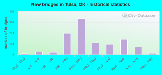
- New bridges - historical statistics
- 11910-1919
- 11920-1929
- 91930-1939
- 261940-1949
- 221950-1959
- 1971960-1969
- 3341970-1979
- 1101980-1989
- 961990-1999
- 1422000-2009
- 692010-2019
- 112020-2022
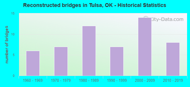
- Reconstructed bridges - Historical Statistics
- 61960-1969
- 71970-1979
- 121980-1989
- 71990-1999
- 142000-2009
- 82010-2019
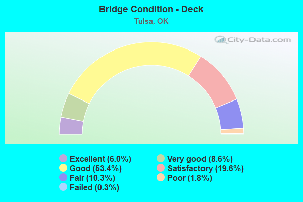
- Bridge Condition - Deck
- 6.0%Excellent
- 8.6%Very good
- 53.4%Good
- 19.6%Satisfactory
- 10.3%Fair
- 1.8%Poor
- 0.3%Failed
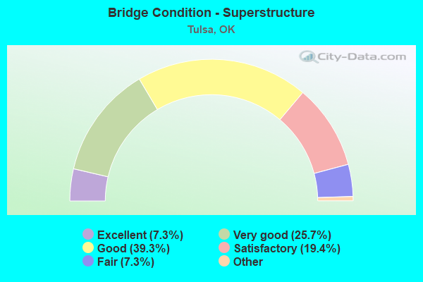
- Bridge Condition - Superstructure
- 7.3%Excellent
- 25.7%Very good
- 39.3%Good
- 19.4%Satisfactory
- 7.3%Fair
- 1.0%Poor
- 0.3%Critical
- 0.3%Failed
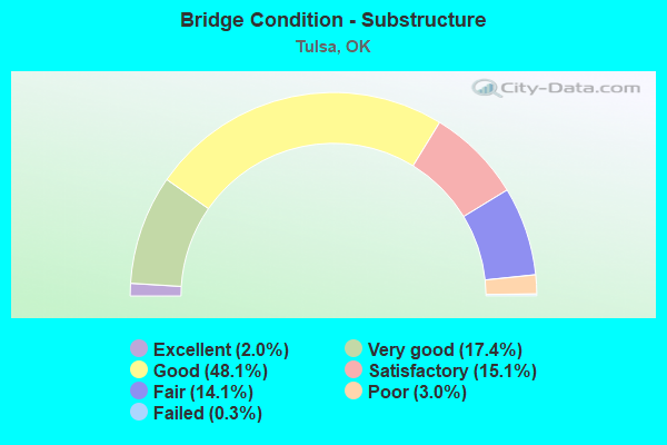
- Bridge Condition - Substructure
- 2.0%Excellent
- 17.4%Very good
- 48.1%Good
- 15.1%Satisfactory
- 14.1%Fair
- 3.0%Poor
- 0.3%Failed
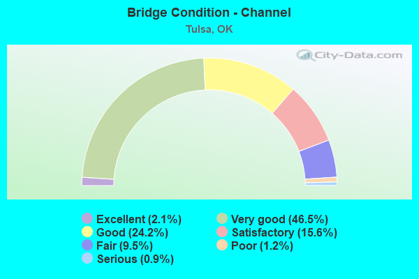
- Bridge Condition - Channel
- 2.1%Excellent
- 46.5%Very good
- 24.2%Good
- 15.6%Satisfactory
- 9.5%Fair
- 1.2%Poor
- 0.9%Serious
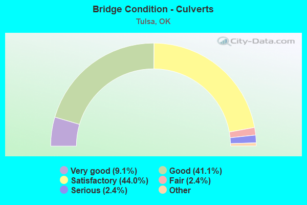
- Bridge Condition - Culverts
- 9.1%Excellent
- 41.1%Very good
- 44.0%Good
- 2.4%Satisfactory
- 2.4%Fair
- 1.0%Poor
- 2.4%Serious
Find on map >> Show street view
Structure Number: 17253, Location: 1.7 MI SE SHERIDAN RD (Lat: 36.177258, Lng: -95.885167), Route carried "on" structure: State highway 11, Year Built: 1968, Status: Open, Structure Length: 4.59m (15.06ft), Average Daily Traffic: 17,150 (year 2020), Truck Traffic: 8%, Average Future Daily Traffic: 27,440 (year 2040), Design Load: HL 93, Features Intersected: PINE ST UNDER
Minimum Vertical Clearance: 30+ m (98+ ft), Kilometerpoint: 12.144, Lanes on structure: 2, Lanes under structure: 5, Base Highway Network: Yes, Owner: State Highway Agency, Approaching Roadway Width: 11.6m (38.1ft), Skew: 12 degrees, Material/Design: Steel, Design/Construction: Stringer/Multi-beam, Number Of Spans In Main Unit: 3, Length of Maximum Span: 25.4m (83.3ft), Curb-To-Curb Width: 11.0m (36.1ft), Out-to-Out Width: 11.9m (39.0ft)
Condition: Deck: Excellent, Superstructure: Excellent, Substructure: Very good, Operating Rating: 45.6 metric tons, Method Used To Determine Operating Rating: Load and Resistance Factor (LRFR), Inventory Rating: 35.2 metric tons, Method Used To Determine Inventory Rating: Load and Resistance Factor (LRFR), Structural Evaluation: Equal to present desirable criteria, Deck Geometry: Somewhat better than minimum adequacy, Underclear: Meets minimum limits, Approach Roadway Alignment: Equal to present desirable criteria, Length Of Structure Improvement: 8.56m (28.08ft), Designated Inspection Frequency: Every 24 months, Inspection Date: December 2020, Bridge Improvement Cost: $1,098,000, Roadway Improvement Cost: $1,811,000, Total Project Cost: $3,074,000 ( Estimate for 2015), Deck Structure Type: Concrete Cast-file-Place, Wearing Surface/Protective System: Wearing Surface: Monolithic Concrete, Membrane: Epoxy, Deck Protection: Epoxy Coated Reinforcing
Find on map >> Show street view
Structure Number: 17262, Location: 1.7 MI SE SHERIDAN RD (Lat: 36.177258, Lng: -95.884794), Route carried "on" structure: State highway 11, Year Built: 1968, Status: Open, Structure Length: 4.49m (14.73ft), Average Daily Traffic: 17,150 (year 2020), Truck Traffic: 8%, Average Future Daily Traffic: 27,440 (year 2040), Design Load: HL 93, Features Intersected: PINE ST UNDER
Minimum Vertical Clearance: 30+ m (98+ ft), Kilometerpoint: 12.144, Lanes on structure: 2, Lanes under structure: 5, Base Highway Network: Yes, Owner: State Highway Agency, Approaching Roadway Width: 12.2m (40.0ft), Skew: 11 degrees, Material/Design: Steel, Design/Construction: Stringer/Multi-beam, Number Of Spans In Main Unit: 3, Length of Maximum Span: 24.9m (81.7ft), Curb-To-Curb Width: 11.0m (36.1ft), Out-to-Out Width: 11.9m (39.0ft)
Condition: Deck: Excellent, Superstructure: Excellent, Substructure: Very good, Operating Rating: 46.3 metric tons, Method Used To Determine Operating Rating: Load and Resistance Factor (LRFR), Inventory Rating: 35.7 metric tons, Method Used To Determine Inventory Rating: Load and Resistance Factor (LRFR), Structural Evaluation: Equal to present desirable criteria, Deck Geometry: Somewhat better than minimum adequacy, Underclear: Meets minimum limits, Approach Roadway Alignment: Equal to present desirable criteria, Length Of Structure Improvement: 5.91m (19.39ft), Designated Inspection Frequency: Every 24 months, Inspection Date: December 2020, Bridge Improvement Cost: $758,000, Roadway Improvement Cost: $1,251,000, Total Project Cost: $2,122,000 ( Estimate for 2015), Deck Structure Type: Concrete Cast-file-Place, Wearing Surface/Protective System: Wearing Surface: Monolithic Concrete, Membrane: Epoxy, Deck Protection: Epoxy Coated Reinforcing
Find on map >> Show street view
Structure Number: 17283, Location: 1.0 MI E PEORIA AVE (Lat: 36.143017, Lng: -95.958494), Route carried "on" structure: US 64, Year Built: 1968, Status: Open, Structure Length: 5.06m (16.60ft), Average Daily Traffic: 42,400 (year 2020), Truck Traffic: 8%, Average Future Daily Traffic: 67,840 (year 2040), Design Load: HL 93, Features Intersected: LEWIS AVE UNDER
Minimum Vertical Clearance: 30.48m (100.00ft), Kilometerpoint: 2.253, Lanes on structure: 3, Lanes under structure: 6, Base Highway Network: Yes, Owner: State Highway Agency, Approaching Roadway Width: 15.2m (49.9ft), Skew: 10 degrees, Material/Design: Steel, Design/Construction: Stringer/Multi-beam, Number Of Spans In Main Unit: 4, Length of Maximum Span: 15.0m (49.2ft), Curb-To-Curb Width: 15.2m (49.9ft), Out-to-Out Width: 16.2m (53.1ft)
Condition: Deck: Excellent, Superstructure: Excellent, Substructure: Very good, Operating Rating: 45.6 metric tons, Method Used To Determine Operating Rating: Load and Resistance Factor (LRFR), Inventory Rating: 35.2 metric tons, Method Used To Determine Inventory Rating: Load and Resistance Factor (LRFR), Structural Evaluation: Equal to present desirable criteria, Deck Geometry: Meets minimum limits, Underclear: Meets minimum limits, Approach Roadway Alignment: Equal to present desirable criteria, Length Of Structure Improvement: 5.87m (19.26ft), Designated Inspection Frequency: Every 24 months, Inspection Date: October 2020, Bridge Improvement Cost: $1,055,000, Roadway Improvement Cost: $1,740,000, Total Project Cost: $2,953,000 ( Estimate for 2015), Deck Structure Type: Concrete Cast-file-Place, Wearing Surface/Protective System: Wearing Surface: Monolithic Concrete, Membrane: Epoxy, Deck Protection: Epoxy Coated Reinforcing
Find on map >> Show street view
Structure Number: 17284, Location: 1.0 MI E PEORIA AVE (Lat: 36.142622, Lng: -95.958494), Route carried "on" structure: US 64, Year Built: 1968, Status: Open, Structure Length: 5.10m (16.73ft), Average Daily Traffic: 42,850 (year 2020), Truck Traffic: 8%, Average Future Daily Traffic: 68,560 (year 2040), Design Load: HL 93, Features Intersected: LEWIS AVE UNDER
Minimum Vertical Clearance: 30.48m (100.00ft), Kilometerpoint: 3.626, Lanes on structure: 3, Lanes under structure: 6, Base Highway Network: Yes, Owner: State Highway Agency, Approaching Roadway Width: 15.2m (49.9ft), Skew: 10 degrees, Material/Design: Steel, Design/Construction: Stringer/Multi-beam, Number Of Spans In Main Unit: 4, Length of Maximum Span: 15.2m (49.9ft), Curb-To-Curb Width: 15.2m (49.9ft), Out-to-Out Width: 16.2m (53.1ft)
Condition: Deck: Very good, Superstructure: Excellent, Substructure: Very good, Operating Rating: 43.9 metric tons, Method Used To Determine Operating Rating: Load and Resistance Factor (LRFR), Inventory Rating: 33.8 metric tons, Method Used To Determine Inventory Rating: Load and Resistance Factor (LRFR), Structural Evaluation: Equal to present desirable criteria, Deck Geometry: Meets minimum limits, Underclear: Meets minimum limits, Approach Roadway Alignment: Equal to present desirable criteria, Length Of Structure Improvement: 5.87m (19.26ft), Designated Inspection Frequency: Every 24 months, Inspection Date: September 2020, Bridge Improvement Cost: $1,055,000, Roadway Improvement Cost: $1,740,000, Total Project Cost: $2,953,000 ( Estimate for 2015), Deck Structure Type: Concrete Cast-file-Place, Wearing Surface/Protective System: Wearing Surface: Monolithic Concrete, Membrane: Epoxy, Deck Protection: Epoxy Coated Reinforcing
Find on map >> Show street view
Structure Number: 17285, Location: 1.2 MI E PEORIA AVE (Lat: 36.140764, Lng: -95.954103), Route carried "on" structure: US 64, Year Built: 1968, Status: Open, Structure Length: 5.10m (16.73ft), Average Daily Traffic: 42,850 (year 2020), Truck Traffic: 8%, Average Future Daily Traffic: 68,560 (year 2040), Design Load: HL 93, Features Intersected: 15 ST. UNDER
Minimum Vertical Clearance: 30.48m (100.00ft), Kilometerpoint: 2.573, Lanes on structure: 3, Lanes under structure: 4, Base Highway Network: Yes, Owner: State Highway Agency, Approaching Roadway Width: 15.2m (49.9ft), Skew: 12 degrees, Material/Design: Steel, Design/Construction: Stringer/Multi-beam, Number Of Spans In Main Unit: 4, Length of Maximum Span: 13.7m (44.9ft), Curb-To-Curb Width: 15.2m (49.9ft), Out-to-Out Width: 16.2m (53.1ft)
Condition: Deck: Excellent, Superstructure: Excellent, Substructure: Very good, Operating Rating: 56.6 metric tons, Method Used To Determine Operating Rating: Load and Resistance Factor (LRFR), Inventory Rating: 43.6 metric tons, Method Used To Determine Inventory Rating: Load and Resistance Factor (LRFR), Structural Evaluation: Equal to present desirable criteria, Deck Geometry: Meets minimum limits, Underclear: Meets minimum limits, Approach Roadway Alignment: Equal to present desirable criteria, Length Of Structure Improvement: 6.17m (20.24ft), Designated Inspection Frequency: Every 24 months, Inspection Date: September 2020, Bridge Improvement Cost: $1,108,000, Roadway Improvement Cost: $1,829,000, Total Project Cost: $3,104,000 ( Estimate for 2015), Deck Structure Type: Concrete Cast-file-Place, Wearing Surface/Protective System: Wearing Surface: Monolithic Concrete, Membrane: Epoxy, Deck Protection: Epoxy Coated Reinforcing
Find on map >> Show street view
Structure Number: 17302, Location: 1.2 MI E PEORIA AVE (Lat: 36.140744, Lng: -95.954881), Route carried "on" structure: US 64, Year Built: 1968, Status: Open, Structure Length: 5.32m (17.45ft), Average Daily Traffic: 42,850 (year 2020), Truck Traffic: 8%, Average Future Daily Traffic: 68,560 (year 2040), Design Load: HL 93, Features Intersected: 15 ST. UNDER
Minimum Vertical Clearance: 30.48m (100.00ft), Kilometerpoint: 4.142, Lanes on structure: 4, Lanes under structure: 4, Base Highway Network: Yes, Owner: State Highway Agency, Approaching Roadway Width: 15.2m (49.9ft), Skew: 13 degrees, Material/Design: Steel, Design/Construction: Stringer/Multi-beam, Number Of Spans In Main Unit: 4, Length of Maximum Span: 14.0m (45.9ft), Curb-To-Curb Width: 16.3m (53.5ft), Out-to-Out Width: 17.2m (56.4ft)
Condition: Deck: Excellent, Superstructure: Excellent, Substructure: Very good, Operating Rating: 53.2 metric tons, Method Used To Determine Operating Rating: Load and Resistance Factor (LRFR), Inventory Rating: 41.0 metric tons, Method Used To Determine Inventory Rating: Load and Resistance Factor (LRFR), Structural Evaluation: Equal to present desirable criteria, Deck Geometry: High priority of replacement, Underclear: Meets minimum limits, Approach Roadway Alignment: Equal to present desirable criteria, Length Of Structure Improvement: 6.84m (22.44ft), Designated Inspection Frequency: Every 24 months, Inspection Date: September 2020, Bridge Improvement Cost: $1,228,000, Roadway Improvement Cost: $2,027,000, Total Project Cost: $3,439,000 ( Estimate for 2015), Deck Structure Type: Concrete Cast-file-Place, Wearing Surface/Protective System: Wearing Surface: Monolithic Concrete, Membrane: Epoxy, Deck Protection: Epoxy Coated Reinforcing
Find on map >> Show street view
Structure Number: 17303, Location: 1.8 MI E PEORIA AVE (Lat: 36.133478, Lng: -95.948836), Route carried "on" structure: US 64, Year Built: 1968, Status: Open, Structure Length: 5.43m (17.81ft), Average Daily Traffic: 42,850 (year 2020), Truck Traffic: 8%, Average Future Daily Traffic: 68,560 (year 2040), Design Load: HS 20, Features Intersected: 21ST ST. UNDER
Minimum Vertical Clearance: 30+ m (98+ ft), Kilometerpoint: 3.541, Lanes on structure: 3, Lanes under structure: 4, Base Highway Network: Yes, Owner: State Highway Agency, Approaching Roadway Width: 15.2m (49.9ft), Skew: 13 degrees, Material/Design: Steel, Design/Construction: Stringer/Multi-beam, Number Of Spans In Main Unit: 4, Length of Maximum Span: 14.0m (45.9ft), Curb-To-Curb Width: 14.2m (46.6ft), Out-to-Out Width: 15.6m (51.2ft)
Condition: Deck: Fair, Superstructure: Satisfactory, Substructure: Fair, Operating Rating: 69.7 metric tons, Method Used To Determine Operating Rating: Load Factor (LF), Inventory Rating: 41.8 metric tons, Method Used To Determine Inventory Rating: Load Factor (LF), Structural Evaluation: Somewhat better than minimum adequacy, Deck Geometry: Meets minimum limits, Underclear: Meets minimum limits, Approach Roadway Alignment: Equal to present desirable criteria, Length Of Structure Improvement: 6.84m (22.44ft), Designated Inspection Frequency: Every 24 months, Inspection Date: September 2020, Bridge Improvement Cost: $1,228,000, Roadway Improvement Cost: $2,027,000, Total Project Cost: $3,439,000 ( Estimate for 2015), Deck Structure Type: Concrete Cast-file-Place, Wearing Surface/Protective System: Wearing Surface: Monolithic Concrete
Find on map >> Show street view
Structure Number: 17304, Location: 1.8 MI E PEORIA AVE (Lat: 36.133475, Lng: -95.949356), Route carried "on" structure: US 64, Year Built: 1968, Status: Open, Structure Length: 5.43m (17.81ft), Average Daily Traffic: 42,850 (year 2020), Truck Traffic: 8%, Average Future Daily Traffic: 68,560 (year 2040), Design Load: HS 20, Features Intersected: 21ST ST. UNDER
Minimum Vertical Clearance: 30+ m (98+ ft), Kilometerpoint: 3.541, Lanes on structure: 3, Lanes under structure: 4, Base Highway Network: Yes, Owner: State Highway Agency, Approaching Roadway Width: 14.2m (46.6ft), Skew: 13 degrees, Material/Design: Steel, Design/Construction: Stringer/Multi-beam, Number Of Spans In Main Unit: 4, Length of Maximum Span: 14.0m (45.9ft), Curb-To-Curb Width: 14.2m (46.6ft), Out-to-Out Width: 15.6m (51.2ft)
Condition: Deck: Fair, Superstructure: Satisfactory, Substructure: Fair, Operating Rating: 69.7 metric tons, Method Used To Determine Operating Rating: Load Factor (LF), Inventory Rating: 41.8 metric tons, Method Used To Determine Inventory Rating: Load Factor (LF), Structural Evaluation: Somewhat better than minimum adequacy, Deck Geometry: Meets minimum limits, Underclear: Meets minimum limits, Approach Roadway Alignment: Equal to present desirable criteria, Length Of Structure Improvement: 6.84m (22.44ft), Designated Inspection Frequency: Every 24 months, Inspection Date: September 2020, Bridge Improvement Cost: $1,228,000, Roadway Improvement Cost: $2,027,000, Total Project Cost: $3,439,000 ( Estimate for 2015), Deck Structure Type: Concrete Cast-file-Place, Wearing Surface/Protective System: Wearing Surface: Monolithic Concrete
Find on map >> Show street view
Structure Number: 1731, Location: .65 MI E JCT I 444 (Lat: 36.158889, Lng: -95.967222), Route carried "on" structure: City street , Year Built: 1968, Status: Open, Structure Length: 5.49m (18.01ft), Average Daily Traffic: 5,000 (year 2020), Truck Traffic: 5%, Average Future Daily Traffic: 8,000 (year 2040), Design Load: HS 20, Features Intersected: I-244 UNDER, Facility Carried by Structure: UTICA AVE.
Minimum Vertical Clearance: 30+ m (98+ ft), Kilometerpoint: 12.308, Lanes on structure: 6, Lanes under structure: 8, Owner: State Highway Agency, Approaching Roadway Width: 23.8m (78.1ft), Skew: 20 degrees, Material/Design: Steel continuous, Design/Construction: Stringer/Multi-beam, Number Of Spans In Main Unit: 2, Length of Maximum Span: 27.4m (89.9ft), Curb or Sidewalk Widths: Left: 1.5m (4.9ft), Right: 1.5m (4.9ft), Curb-To-Curb Width: 23.8m (78.1ft), Out-to-Out Width: 27.3m (89.6ft)
Condition: Deck: Fair, Superstructure: Fair, Substructure: Satisfactory, Operating Rating: 47.5 metric tons, Method Used To Determine Operating Rating: Load Factor (LF), Inventory Rating: 28.5 metric tons, Method Used To Determine Inventory Rating: Load Factor (LF), Structural Evaluation: Somewhat better than minimum adequacy, Deck Geometry: Somewhat better than minimum adequacy, Underclear: Somewhat better than minimum adequacy, Approach Roadway Alignment: Equal to present desirable criteria, Length Of Structure Improvement: 8.91m (29.23ft), Designated Inspection Frequency: Every 24 months, Inspection Date: September 2020, Bridge Improvement Cost: $2,286,000, Roadway Improvement Cost: $3,772,000, Total Project Cost: $6,400,000 ( Estimate for 2015), Deck Structure Type: Concrete Cast-file-Place, Wearing Surface/Protective System: Wearing Surface: Monolithic Concrete
Find on map >> Show street view
Structure Number: 17342, Location: 1.4 MI SE SHERIDAN RD (Lat: 36.180456, Lng: -95.886994), Route carried "on" structure: State highway 11, Year Built: 1968, Status: Open, Structure Length: 7.77m (25.49ft), Average Daily Traffic: 17,150 (year 2020), Truck Traffic: 8%, Average Future Daily Traffic: 27,440 (year 2040), Design Load: HS 20, Features Intersected: MEMORIAL RD. UNDER
Minimum Vertical Clearance: 30+ m (98+ ft), Kilometerpoint: 7.144, Lanes on structure: 3, Lanes under structure: 4, Base Highway Network: Yes, Owner: State Highway Agency, Approaching Roadway Width: 13.4m (44.0ft), Skew: 15 degrees, Material/Design: Steel continuous, Design/Construction: Stringer/Multi-beam, Number Of Spans In Main Unit: 2, Number Of Approach Spans: 2, Length of Maximum Span: 20.4m (66.9ft), Curb-To-Curb Width: 13.7m (44.9ft), Out-to-Out Width: 14.6m (47.9ft)
Condition: Deck: Fair, Superstructure: Satisfactory, Substructure: Fair, Operating Rating: 50.6 metric tons, Method Used To Determine Operating Rating: Load Factor (LF), Inventory Rating: 30.4 metric tons, Method Used To Determine Inventory Rating: Load Factor (LF), Structural Evaluation: Somewhat better than minimum adequacy, Deck Geometry: Meets minimum limits, Underclear: Meets minimum limits, Approach Roadway Alignment: Equal to present desirable criteria, Length Of Structure Improvement: 9.64m (31.63ft), Designated Inspection Frequency: Every 24 months, Inspection Date: December 2020, Bridge Improvement Cost: $1,731,000, Roadway Improvement Cost: $2,856,000, Total Project Cost: $4,846,000 ( Estimate for 2015), Deck Structure Type: Concrete Cast-file-Place, Wearing Surface/Protective System: Wearing Surface: Monolithic Concrete
Find on map >> Show street view
Structure Number: 17343, Location: 1.4 MI SE SHERIDAN RD (Lat: 36.179933, Lng: -95.886994), Route carried "on" structure: State highway 11, Year Built: 1968, Status: Open, Structure Length: 7.77m (25.49ft), Average Daily Traffic: 17,150 (year 2020), Truck Traffic: 8%, Average Future Daily Traffic: 27,440 (year 2040), Design Load: HS 20, Features Intersected: MEMORIAL RD. UNDER
Minimum Vertical Clearance: 30+ m (98+ ft), Kilometerpoint: 11.497, Lanes on structure: 2, Lanes under structure: 4, Base Highway Network: Yes (, Subroute: 1), Owner: State Highway Agency, Approaching Roadway Width: 12.2m (40.0ft), Skew: 15 degrees, Material/Design: Steel continuous, Design/Construction: Stringer/Multi-beam, Number Of Spans In Main Unit: 2, Number Of Approach Spans: 2, Length of Maximum Span: 20.4m (66.9ft), Curb-To-Curb Width: 11.3m (37.1ft), Out-to-Out Width: 12.2m (40.0ft)
Condition: Deck: Satisfactory, Superstructure: Good, Substructure: Fair, Operating Rating: 51.0 metric tons, Method Used To Determine Operating Rating: Load Factor (LF), Inventory Rating: 30.6 metric tons, Method Used To Determine Inventory Rating: Load Factor (LF), Structural Evaluation: Somewhat better than minimum adequacy, Deck Geometry: Somewhat better than minimum adequacy, Underclear: Meets minimum limits, Approach Roadway Alignment: Equal to present desirable criteria, Length Of Structure Improvement: 9.64m (31.63ft), Designated Inspection Frequency: Every 24 months, Inspection Date: December 2020, Bridge Improvement Cost: $1,236,000, Roadway Improvement Cost: $2,040,000, Total Project Cost: $3,462,000 ( Estimate for 2015), Deck Structure Type: Concrete Cast-file-Place, Wearing Surface/Protective System: Wearing Surface: Monolithic Concrete
Find on map >> Show street view
Structure Number: 17348, Location: 1.0 MI E PEORIA AVE (Lat: 36.142986, Lng: -95.956758), Route carried "on" structure: US 64, Year Built: 1968, Status: Open, Structure Length: 9.59m (31.46ft), Average Daily Traffic: 42,400 (year 2020), Truck Traffic: 8%, Average Future Daily Traffic: 67,840 (year 2040), Design Load: HS 20, Features Intersected: U.P. R.R. UNDER
Minimum Vertical Clearance: 30.48m (100.00ft), Kilometerpoint: 3.885, Lanes on structure: 3, Base Highway Network: Yes, Owner: State Highway Agency, Approaching Roadway Width: 16.5m (54.1ft), Skew: 10 degrees, Material/Design: Steel, Design/Construction: Stringer/Multi-beam, Number Of Spans In Main Unit: 7, Length of Maximum Span: 14.4m (47.2ft), Curb-To-Curb Width: 16.5m (54.1ft), Out-to-Out Width: 17.4m (57.1ft)
Condition: Deck: Excellent, Superstructure: Good, Substructure: Very good, Operating Rating: 49.3 metric tons, Method Used To Determine Operating Rating: Load Factor (LF), Inventory Rating: 29.5 metric tons, Method Used To Determine Inventory Rating: Load Factor (LF), Structural Evaluation: Better than present minimum criteria, Deck Geometry: Equal to present minimum criteria, Underclear: Somewhat better than minimum adequacy, Approach Roadway Alignment: Somewhat better than minimum adequacy, Length Of Structure Improvement: 10.49m (34.42ft), Designated Inspection Frequency: Every 24 months, Inspection Date: July 2021, Bridge Improvement Cost: $1,885,000, Roadway Improvement Cost: $3,110,000, Total Project Cost: $5,277,000 ( Estimate for 2015), Deck Structure Type: Concrete Cast-file-Place, Wearing Surface/Protective System: Wearing Surface: Monolithic Concrete, Membrane: Epoxy, Deck Protection: Epoxy Coated Reinforcing
Find on map >> Show street view
Structure Number: 17445, Location: 65TH W AVE S OF KEYS EXPR (Lat: 36.151158, Lng: -96.065411), Route carried "on" structure: County highway N3900, Year Built: 1969, Status: Open, Structure Length: 1.83m (6.00ft), Average Daily Traffic: 1,000 (year 2020), Truck Traffic: 10%, Average Future Daily Traffic: 1,600 (year 2040), Design Load: HS 20, Features Intersected: HARLOW CREEK
Minimum Vertical Clearance: 30+ m (98+ ft), Kilometerpoint: 1.931, Lanes on structure: 4, Owner: County Highway Agency, Approaching Roadway Width: 16.4m (53.8ft), Skew: 23 degrees, Material/Design: Concrete, Design/Construction: Culvert, Number Of Spans In Main Unit: 3, Length of Maximum Span: 4.6m (15.1ft), Curb or Sidewalk Widths: Left: 1.3m (4.3ft), Right: 1.3m (4.3ft), Curb-To-Curb Width: 49.4m (162.1ft), Out-to-Out Width: 50.0m (164.0ft)
Condition: Channel: Good, Culverts: Satisfactory, Operating Rating: 44.5 metric tons, Method Used To Determine Operating Rating: Allowable Stress (AS), Inventory Rating: 32.7 metric tons, Method Used To Determine Inventory Rating: Allowable Stress (AS), Structural Evaluation: Equal to present minimum criteria, Deck Geometry: Superior to present desirable criteria, Waterway Adequacy: Equal to present desirable criteria, Approach Roadway Alignment: Equal to present desirable criteria, Length Of Structure Improvement: 4.75m (15.58ft), Designated Inspection Frequency: Every 24 months, Inspection Date: October 2021, Bridge Improvement Cost: $100,000, Roadway Improvement Cost: $75,000, Total Project Cost: $225,000 ( Estimate for 2015)
Find on map >> Show street view
Structure Number: 17446, Location: 3200 S CINCINNATI (Lat: 36.116500, Lng: -95.981828), Route carried "on" structure: City street N3946, Year Built: 1969, Status: Open, Structure Length: 1.83m (6.00ft), Average Daily Traffic: 500 (year 2020), Truck Traffic: 10%, Average Future Daily Traffic: 800 (year 2040), Design Load: HS 20, Features Intersected: CROW CREEK
Minimum Vertical Clearance: 30+ m (98+ ft), Kilometerpoint: 0.161, Lanes on structure: 2, Owner: City or Municipal Highway Agency, Approaching Roadway Width: 7.9m (25.9ft), Skew: 1 degrees, Material/Design: Steel, Design/Construction: Stringer/Multi-beam, Number Of Spans In Main Unit: 1, Length of Maximum Span: 18.0m (59.1ft), Curb or Sidewalk Widths: Left: 1.6m (5.2ft), Right: 1.6m (5.2ft), Curb-To-Curb Width: 7.9m (25.9ft), Out-to-Out Width: 11.6m (38.1ft)
Condition: Deck: Good, Superstructure: Good, Substructure: Good, Channel: Good, Operating Rating: 44.9 metric tons, Method Used To Determine Operating Rating: Load Factor (LF), Inventory Rating: 26.9 metric tons, Method Used To Determine Inventory Rating: Load Factor (LF), Structural Evaluation: Equal to present minimum criteria, Deck Geometry: Somewhat better than minimum adequacy, Waterway Adequacy: Better than present minimum criteria, Approach Roadway Alignment: Equal to present minimum criteria, Length Of Structure Improvement: 4.75m (15.58ft), Designated Inspection Frequency: Every 24 months, Inspection Date: May 2020, Bridge Improvement Cost: $243,000, Roadway Improvement Cost: $134,000, Total Project Cost: $387,000 ( Estimate for 2015), Deck Structure Type: Concrete Cast-file-Place, Wearing Surface/Protective System: Wearing Surface: Monolithic Concrete
Find on map >> Show street view
Structure Number: 17607, Location: 4.8 MI N I-44 (Lat: 36.147819, Lng: -96.001983), Route carried "on" structure: Interstate 244, Year Built: 1969, Year Reconstructed: 2010, Status: Open, Structure Length: 28.90m (94.82ft), Average Daily Traffic: 31,350 (year 2020), Truck Traffic: 12%, Average Future Daily Traffic: 50,160 (year 2040), Design Load: HS 20, Features Intersected: STREET & BNSF R.R. UNDER
Minimum Vertical Clearance: 30+ m (98+ ft), Kilometerpoint: 7.868, Lanes on structure: 3, Lanes under structure: 6, Base Highway Network: Yes, Owner: State Highway Agency, Approaching Roadway Width: 18.9m (62.0ft), Skew: 10 degrees, Material/Design: Steel continuous, Design/Construction: Stringer/Multi-beam, Number Of Spans In Main Unit: 11, Number Of Approach Spans: 1, Length of Maximum Span: 27.4m (89.9ft), Curb-To-Curb Width: 13.4m (44.0ft), Out-to-Out Width: 14.0m (45.9ft)
Condition: Deck: Satisfactory, Superstructure: Satisfactory, Substructure: Satisfactory, Operating Rating: 47.3 metric tons, Method Used To Determine Operating Rating: Load Factor (LF), Inventory Rating: 28.4 metric tons, Method Used To Determine Inventory Rating: Load Factor (LF), Structural Evaluation: Equal to present minimum criteria, Deck Geometry: Meets minimum limits, Underclear: Meets minimum limits, Approach Roadway Alignment: Equal to present desirable criteria, Length Of Structure Improvement: 31.79m (104.30ft), Designated Inspection Frequency: Every 24 months, Inspection Date: August 2021, Bridge Improvement Cost: $5,709,000, Roadway Improvement Cost: $4,500,000, Total Project Cost: $10,787,000 ( Estimate for 2015), Deck Structure Type: Concrete Cast-file-Place, Wearing Surface/Protective System: Wearing Surface: Monolithic Concrete, Deck Protection: Epoxy Coated Reinforcing
Find on map >> Show street view
Structure Number: 17608, Location: 4.8 MI N I-44 (Lat: 36.147506, Lng: -96.002847), Route carried "on" structure: Interstate 244, Year Built: 1969, Year Reconstructed: 2010, Status: Open, Structure Length: 31.94m (104.79ft), Average Daily Traffic: 31,350 (year 2020), Truck Traffic: 12%, Average Future Daily Traffic: 50,160 (year 2040), Design Load: HS 20, Features Intersected: STREET & BNSF R.R. UNDER
Minimum Vertical Clearance: 30+ m (98+ ft), Kilometerpoint: 7.836, Lanes on structure: 3, Lanes under structure: 5, Base Highway Network: Yes, Owner: State Highway Agency, Approaching Roadway Width: 15.2m (49.9ft), Skew: 10 degrees, Material/Design: Steel continuous, Design/Construction: Stringer/Multi-beam, Number Of Spans In Main Unit: 10, Number Of Approach Spans: 4, Length of Maximum Span: 24.4m (80.1ft), Curb-To-Curb Width: 15.2m (49.9ft), Out-to-Out Width: 15.8m (51.8ft)
Condition: Deck: Very good, Superstructure: Satisfactory, Substructure: Satisfactory, Operating Rating: 49.5 metric tons, Method Used To Determine Operating Rating: Load Factor (LF), Inventory Rating: 29.7 metric tons, Method Used To Determine Inventory Rating: Load Factor (LF), Structural Evaluation: Equal to present minimum criteria, Deck Geometry: Meets minimum limits, Underclear: Meets minimum limits, Approach Roadway Alignment: Better than present minimum criteria, Length Of Structure Improvement: 35.17m (115.39ft), Designated Inspection Frequency: Every 24 months, Inspection Date: August 2021, Bridge Improvement Cost: $6,316,000, Roadway Improvement Cost: $4,500,000, Total Project Cost: $11,428,000 ( Estimate for 2015), Deck Structure Type: Concrete Cast-file-Place, Wearing Surface/Protective System: Wearing Surface: Monolithic Concrete, Deck Protection: Epoxy Coated Reinforcing
Find on map >> Show street view
Structure Number: 17622, Location: 6500 S 89 E (Lat: 36.068092, Lng: -95.877842), Route carried "on" structure: City street N4005, Year Built: 1970, Status: Open, Structure Length: 0.82m (2.69ft), Average Daily Traffic: 400 (year 2020), Truck Traffic: 5%, Average Future Daily Traffic: 640 (year 2040), Design Load: HS 20, Features Intersected: MINGO CREEK
Minimum Vertical Clearance: 30+ m (98+ ft), Kilometerpoint: 0.644, Lanes on structure: 2, Owner: City or Municipal Highway Agency, Approaching Roadway Width: 11.0m (36.1ft), Material/Design: Concrete, Design/Construction: Culvert, Number Of Spans In Main Unit: 2, Length of Maximum Span: 4.0m (13.1ft), Curb-To-Curb Width: 11.0m (36.1ft), Out-to-Out Width: 14.6m (47.9ft)
Condition: Channel: Very good, Culverts: Good, Operating Rating: 63.0 metric tons, Method Used To Determine Operating Rating: Load Factor (LF), Inventory Rating: 37.8 metric tons, Method Used To Determine Inventory Rating: Load Factor (LF), Structural Evaluation: Better than present minimum criteria, Deck Geometry: Equal to present desirable criteria, Waterway Adequacy: Equal to present desirable criteria, Approach Roadway Alignment: Better than present minimum criteria, Length Of Structure Improvement: 3.17m (10.40ft), Designated Inspection Frequency: Every 24 months, Inspection Date: May 2020, Bridge Improvement Cost: $100,000, Roadway Improvement Cost: $75,000, Total Project Cost: $225,000 ( Estimate for 2015)
Find on map >> Show street view
Structure Number: 17753, Location: 3500 E 47 PL. (Lat: 36.095025, Lng: -95.937475), Route carried "on" structure: City street E0637, Year Built: 1970, Status: Open, Structure Length: 0.98m (3.22ft), Average Daily Traffic: 300 (year 2020), Truck Traffic: 10%, Average Future Daily Traffic: 480 (year 2040), Design Load: HS 20, Features Intersected: JOE CREEK
Minimum Vertical Clearance: 30+ m (98+ ft), Kilometerpoint: 0.322, Lanes on structure: 2, Owner: City or Municipal Highway Agency, Approaching Roadway Width: 7.9m (25.9ft), Material/Design: Concrete, Design/Construction: Culvert, Number Of Spans In Main Unit: 3, Length of Maximum Span: 3.0m (9.8ft), Curb or Sidewalk Widths: Left: 0.0m, Right: 1.5m (4.9ft), Curb-To-Curb Width: 7.9m (25.9ft), Out-to-Out Width: 10.4m (34.1ft)
Condition: Channel: Very good, Culverts: Satisfactory, Operating Rating: 42.6 metric tons, Method Used To Determine Operating Rating: Load Factor (LF), Inventory Rating: 32.7 metric tons, Method Used To Determine Inventory Rating: Load Factor (LF), Structural Evaluation: Equal to present minimum criteria, Deck Geometry: Somewhat better than minimum adequacy, Waterway Adequacy: Better than present minimum criteria, Approach Roadway Alignment: Equal to present desirable criteria, Length Of Structure Improvement: 3.47m (11.38ft), Designated Inspection Frequency: Every 24 months, Inspection Date: May 2020, Bridge Improvement Cost: $100,000, Roadway Improvement Cost: $75,000, Total Project Cost: $225,000 ( Estimate for 2015)
Find on map >> Show street view
Structure Number: 17889, Location: .16 MI E JCT I 444 (Lat: 36.159486, Lng: -95.975847), Route carried "on" structure: Interstate 244, Year Built: 1970, Status: Open, Structure Length: 4.54m (14.90ft), Average Daily Traffic: 31,300 (year 2020), Truck Traffic: 12%, Average Future Daily Traffic: 50,080 (year 2040), Design Load: HS 20, Features Intersected: PEORIA AVE. UNDER
Minimum Vertical Clearance: 30+ m (98+ ft), Kilometerpoint: 11.520, Lanes on structure: 6, Lanes under structure: 5, Base Highway Network: Yes, Owner: State Highway Agency, Approaching Roadway Width: 31.1m (102.0ft), Skew: 10 degrees, Material/Design: Steel continuous, Design/Construction: Stringer/Multi-beam, Number Of Spans In Main Unit: 3, Length of Maximum Span: 25.6m (84.0ft), Curb-To-Curb Width: 31.1m (102.0ft), Out-to-Out Width: 32.2m (105.6ft)
Condition: Deck: Very good, Superstructure: Good, Substructure: Good, Operating Rating: 33.1 metric tons, Method Used To Determine Operating Rating: Load Factor (LF), Inventory Rating: 19.9 metric tons, Method Used To Determine Inventory Rating: Load Factor (LF), Structural Evaluation: Somewhat better than minimum adequacy, Deck Geometry: Superior to present desirable criteria, Underclear: Somewhat better than minimum adequacy, Approach Roadway Alignment: Equal to present desirable criteria, Length Of Structure Improvement: 5.80m (19.03ft), Designated Inspection Frequency: Every 24 months, Inspection Date: September 2020, Bridge Improvement Cost: $1,488,000, Roadway Improvement Cost: $2,455,000, Total Project Cost: $4,167,000 ( Estimate for 2015), Deck Structure Type: Concrete Cast-file-Place, Wearing Surface/Protective System: Wearing Surface: Monolithic Concrete, Membrane: Epoxy, Deck Protection: Epoxy Coated Reinforcing
Find on map >> Show street view
Structure Number: 1789, Location: .16 MI E JCT I 444 (Lat: 36.158936, Lng: -95.975847), Route carried "on" structure: Interstate 244, Year Built: 1970, Status: Open, Structure Length: 4.54m (14.90ft), Average Daily Traffic: 31,300 (year 2020), Truck Traffic: 12%, Average Future Daily Traffic: 50,080 (year 2040), Design Load: HS 20, Features Intersected: PEORIA AVE. UNDER
Minimum Vertical Clearance: 30+ m (98+ ft), Kilometerpoint: 11.520, Lanes on structure: 4, Lanes under structure: 4, Base Highway Network: Yes, Owner: State Highway Agency, Approaching Roadway Width: 18.6m (61.0ft), Skew: 10 degrees, Material/Design: Steel continuous, Design/Construction: Stringer/Multi-beam, Number Of Spans In Main Unit: 3, Length of Maximum Span: 25.6m (84.0ft), Curb-To-Curb Width: 18.6m (61.0ft), Out-to-Out Width: 19.5m (64.0ft)
Condition: Deck: Good, Superstructure: Good, Substructure: Good, Operating Rating: 44.0 metric tons, Method Used To Determine Operating Rating: Load Factor (LF), Inventory Rating: 26.4 metric tons, Method Used To Determine Inventory Rating: Load Factor (LF), Structural Evaluation: Equal to present minimum criteria, Deck Geometry: Meets minimum limits, Underclear: Somewhat better than minimum adequacy, Approach Roadway Alignment: Equal to present desirable criteria, Length Of Structure Improvement: 6.70m (21.98ft), Designated Inspection Frequency: Every 24 months, Inspection Date: September 2020, Bridge Improvement Cost: $1,461,000, Roadway Improvement Cost: $2,410,000, Total Project Cost: $4,089,000 ( Estimate for 2015), Deck Structure Type: Concrete Cast-file-Place, Wearing Surface/Protective System: Wearing Surface: Monolithic Concrete, Membrane: Epoxy, Deck Protection: Epoxy Coated Reinforcing
Find on map >> Show street view
Structure Number: 17944, Location: 56TH N. .8 E OF HARVARD A (Lat: 36.234597, Lng: -95.927044), Route carried "on" structure: County highway E0540, Year Built: 1970, Status: Open, Structure Length: 10.36m (33.99ft), Average Daily Traffic: 1,691 (year 2020), Truck Traffic: 10%, Average Future Daily Traffic: 2,706 (year 2040), Design Load: HS 20, Features Intersected: BIRD CREEK
Minimum Vertical Clearance: 30+ m (98+ ft), Kilometerpoint: 1.287, Lanes on structure: 2, Owner: County Highway Agency, Approaching Roadway Width: 7.3m (24.0ft), Skew: 4 degrees, Material/Design: Steel continuous, Design/Construction: Stringer/Multi-beam, Number Of Spans In Main Unit: 4, Length of Maximum Span: 30.5m (100.1ft), Curb-To-Curb Width: 9.5m (31.2ft), Out-to-Out Width: 10.4m (34.1ft)
Condition: Deck: Satisfactory, Superstructure: Good, Substructure: Good, Channel: Fair, Operating Rating: 44.5 metric tons, Method Used To Determine Operating Rating: Allowable Stress (AS), Inventory Rating: 32.7 metric tons, Method Used To Determine Inventory Rating: Allowable Stress (AS), Structural Evaluation: Better than present minimum criteria, Deck Geometry: Somewhat better than minimum adequacy, Waterway Adequacy: Somewhat better than minimum adequacy, Approach Roadway Alignment: Meets minimum limits, Length Of Structure Improvement: 11.91m (39.07ft), Designated Inspection Frequency: Every 24 months, Inspection Date: September 2021, Bridge Improvement Cost: $608,000, Roadway Improvement Cost: $335,000, Total Project Cost: $953,000 ( Estimate for 2015), Deck Structure Type: Concrete Cast-file-Place, Wearing Surface/Protective System: Wearing Surface: Monolithic Concrete
Find on map >> Show street view
Structure Number: 17945, Location: 56ST N .05E OF MEMORIAL R (Lat: 36.235050, Lng: -95.887914), Route carried "on" structure: County highway E0540, Year Built: 1970, Status: Open, Structure Length: 11.03m (36.19ft), Average Daily Traffic: 1,766 (year 2020), Truck Traffic: 10%, Average Future Daily Traffic: 2,826 (year 2040), Design Load: HS 20, Features Intersected: BIRD CREEK
Minimum Vertical Clearance: 30+ m (98+ ft), Kilometerpoint: 0.000, Lanes on structure: 2, Owner: County Highway Agency, Approaching Roadway Width: 8.5m (27.9ft), Material/Design: Prestressed concrete, Design/Construction: Stringer/Multi-beam, Number Of Spans In Main Unit: 4, Length of Maximum Span: 27.4m (89.9ft), Curb-To-Curb Width: 9.4m (30.8ft), Out-to-Out Width: 10.4m (34.1ft)
Condition: Deck: Fair, Superstructure: Satisfactory, Substructure: Poor, Channel: Fair, Operating Rating: 44.5 metric tons, Method Used To Determine Operating Rating: Allowable Stress (AS), Inventory Rating: 32.7 metric tons, Method Used To Determine Inventory Rating: Allowable Stress (AS), Structural Evaluation: Meets minimum limits, Deck Geometry: Somewhat better than minimum adequacy, Waterway Adequacy: Meets minimum limits, Approach Roadway Alignment: Somewhat better than minimum adequacy, Length Of Structure Improvement: 12.32m (40.42ft), Designated Inspection Frequency: Every 24 months, Inspection Date: September 2021, Bridge Improvement Cost: $629,000, Roadway Improvement Cost: $346,000, Total Project Cost: $986,000 ( Estimate for 2015), Deck Structure Type: Concrete Cast-file-Place, Wearing Surface/Protective System: Wearing Surface: Monolithic Concrete
Find on map >> Show street view
Structure Number: 17969, Location: 3800 S. MEMORIAL DR. (Lat: 36.106894, Lng: -95.887228), Route carried "on" structure: City street N4000, Year Built: 1971, Year Reconstructed: 2001, Status: Open, Structure Length: 0.85m (2.79ft), Average Daily Traffic: 24,000 (year 2020), Truck Traffic: 5%, Average Future Daily Traffic: 38,400 (year 2040), Design Load: HS 20, Features Intersected: FULTON CREEK
Minimum Vertical Clearance: 30+ m (98+ ft), Kilometerpoint: 1.448, Lanes on structure: 5, Owner: City or Municipal Highway Agency, Approaching Roadway Width: 15.8m (51.8ft), Skew: 20 degrees, Material/Design: Concrete, Design/Construction: Culvert, Number Of Spans In Main Unit: 3, Length of Maximum Span: 2.4m (7.9ft)
Condition: Channel: Good, Culverts: Good, Operating Rating: 42.6 metric tons, Method Used To Determine Operating Rating: Load Factor (LF), Inventory Rating: 32.7 metric tons, Method Used To Determine Inventory Rating: Load Factor (LF), Structural Evaluation: Better than present minimum criteria, Waterway Adequacy: Equal to present desirable criteria, Approach Roadway Alignment: Equal to present desirable criteria, Length Of Structure Improvement: 3.16m (10.37ft), Designated Inspection Frequency: Every 24 months, Inspection Date: May 2020, Bridge Improvement Cost: $100,000, Roadway Improvement Cost: $75,000, Total Project Cost: $225,000 ( Estimate for 2015)
Find on map >> Show street view
Structure Number: 17988, Location: 2.2 MI E TULSA C/L (Lat: 36.229550, Lng: -95.775342), Route carried "on" structure: State highway 266, Year Built: 1971, Status: Open, Structure Length: 1.22m (4.00ft), Average Daily Traffic: 10,800 (year 2020), Truck Traffic: 25%, Average Future Daily Traffic: 17,280 (year 2040), Design Load: HS 20, Features Intersected: CROOKED CREEK
Minimum Vertical Clearance: 30+ m (98+ ft), Kilometerpoint: 3.652, Lanes on structure: 2, Owner: State Highway Agency, Approaching Roadway Width: 13.4m (44.0ft), Material/Design: Concrete, Design/Construction: Culvert, Number Of Spans In Main Unit: 3, Length of Maximum Span: 3.7m (12.1ft)
Condition: Channel: Good, Culverts: Very good, Operating Rating: 90.7 metric tons, Method Used To Determine Operating Rating: Load Factor (LF), Inventory Rating: 74.5 metric tons, Method Used To Determine Inventory Rating: Load Factor (LF), Structural Evaluation: Equal to present desirable criteria, Waterway Adequacy: Equal to present minimum criteria, Approach Roadway Alignment: Equal to present desirable criteria, Length Of Structure Improvement: 1.19m (3.90ft), Designated Inspection Frequency: Every 24 months, Inspection Date: May 2020, Bridge Improvement Cost: $304,000, Roadway Improvement Cost: $502,000, Total Project Cost: $853,000 ( Estimate for 2015)
Find on map >> Show street view
Structure Number: 17991, Location: 11.6 MI.N I-244 (Lat: 36.312317, Lng: -95.923675), Route carried "on" structure: US 75, Year Built: 1971, Year Reconstructed: 1985, Status: Open, Structure Length: 1.01m (3.31ft), Average Daily Traffic: 23,600 (year 2020), Truck Traffic: 8%, Average Future Daily Traffic: 37,760 (year 2040), Design Load: HS 20, Features Intersected: CREEK
Minimum Vertical Clearance: 30+ m (98+ ft), Kilometerpoint: 18.824, Lanes on structure: 4, Base Highway Network: Yes, Owner: State Highway Agency, Approaching Roadway Width: 12.2m (40.0ft), Material/Design: Concrete, Design/Construction: Culvert, Number Of Spans In Main Unit: 3, Length of Maximum Span: 3.0m (9.8ft)
Condition: Channel: Satisfactory, Culverts: Good, Operating Rating: 42.5 metric tons, Method Used To Determine Operating Rating: Load Factor (LF), Inventory Rating: 25.5 metric tons, Method Used To Determine Inventory Rating: Load Factor (LF), Structural Evaluation: Equal to present minimum criteria, Waterway Adequacy: Better than present minimum criteria, Approach Roadway Alignment: Equal to present desirable criteria, Length Of Structure Improvement: 1.01m (3.31ft), Designated Inspection Frequency: Every 24 months, Inspection Date: December 2020, Bridge Improvement Cost: $302,000, Roadway Improvement Cost: $498,000, Total Project Cost: $845,000 ( Estimate for 2015)
Find on map >> Show street view
Structure Number: 17992, Location: 2.7 MI S JCT SH 20 (Lat: 36.325342, Lng: -95.923664), Route carried "on" structure: US 75, Year Built: 1971, Status: Open, Structure Length: 1.16m (3.81ft), Average Daily Traffic: 23,600 (year 2020), Truck Traffic: 8%, Average Future Daily Traffic: 37,760 (year 2040), Design Load: HS 20, Features Intersected: PANTHER CREEK
Minimum Vertical Clearance: 30+ m (98+ ft), Kilometerpoint: 20.257, Lanes on structure: 6, Base Highway Network: Yes, Owner: State Highway Agency, Approaching Roadway Width: 12.2m (40.0ft), Skew: 3 degrees, Material/Design: Concrete, Design/Construction: Culvert, Number Of Spans In Main Unit: 3, Length of Maximum Span: 3.0m (9.8ft)
Condition: Channel: Very good, Culverts: Good, Operating Rating: 90.7 metric tons, Method Used To Determine Operating Rating: Load Factor (LF), Inventory Rating: 72.2 metric tons, Method Used To Determine Inventory Rating: Load Factor (LF), Structural Evaluation: Better than present minimum criteria, Waterway Adequacy: Better than present minimum criteria, Approach Roadway Alignment: Equal to present desirable criteria, Length Of Structure Improvement: 1.16m (3.81ft), Designated Inspection Frequency: Every 24 months, Inspection Date: December 2020, Bridge Improvement Cost: $361,000, Roadway Improvement Cost: $595,000, Total Project Cost: $1,010,000 ( Estimate for 2015)
Find on map >> Show street view
Structure Number: 18005, Location: 10.9 MI N JCT SH 67 (Lat: 36.102825, Lng: -96.007969), Route carried "on" structure: US 75, Year Built: 1971, Status: Open, Structure Length: 1.37m (4.49ft), Average Daily Traffic: 50,100 (year 2020), Truck Traffic: 8%, Average Future Daily Traffic: 80,160 (year 2040), Design Load: HS 20, Features Intersected: RED FORK CREEK
Minimum Vertical Clearance: 30+ m (98+ ft), Kilometerpoint: 17.539, Lanes on structure: 6, Base Highway Network: Yes, Owner: State Highway Agency, Approaching Roadway Width: 12.2m (40.0ft), Skew: 1 degrees, Material/Design: Concrete, Design/Construction: Culvert, Number Of Spans In Main Unit: 3, Length of Maximum Span: 4.3m (14.1ft)
Condition: Channel: Very good, Culverts: Good, Structural Evaluation: Better than present minimum criteria, Waterway Adequacy: Equal to present desirable criteria, Approach Roadway Alignment: Equal to present desirable criteria, Length Of Structure Improvement: 1.37m (4.49ft), Designated Inspection Frequency: Every 24 months, Inspection Date: December 2020, Bridge Improvement Cost: $753,000, Roadway Improvement Cost: $1,242,000, Total Project Cost: $2,107,000 ( Estimate for 2015)
Find on map >> Show street view
Structure Number: 1802, Location: 5.8 MI N I-44 (Lat: 36.160692, Lng: -95.997883), Route carried "on" structure: Interstate 244, Year Built: 1971, Status: Open, Structure Length: 2.38m (7.81ft), Average Daily Traffic: 66,400 (year 2020), Truck Traffic: 12%, Average Future Daily Traffic: 106,240 (year 2040), Design Load: HS 20, Features Intersected: CHEYENNE AVE. UNDER
Minimum Vertical Clearance: 30+ m (98+ ft), Kilometerpoint: 9.445, Lanes on structure: 9, Lanes under structure: 2, Base Highway Network: Yes, Owner: State Highway Agency, Approaching Roadway Width: 25.0m (82.0ft), Skew: 30 degrees, Material/Design: Steel, Design/Construction: Stringer/Multi-beam, Number Of Spans In Main Unit: 1, Length of Maximum Span: 23.5m (77.1ft), Curb-To-Curb Width: 42.7m (140.1ft), Out-to-Out Width: 43.2m (141.7ft)
Condition: Deck: Good, Superstructure: Good, Substructure: Good, Operating Rating: 75.9 metric tons, Method Used To Determine Operating Rating: Load Factor (LF), Inventory Rating: 45.5 metric tons, Method Used To Determine Inventory Rating: Load Factor (LF), Structural Evaluation: Better than present minimum criteria, Deck Geometry: Superior to present desirable criteria, Underclear: Equal to present minimum criteria, Approach Roadway Alignment: Equal to present desirable criteria, Length Of Structure Improvement: 5.80m (19.03ft), Designated Inspection Frequency: Every 24 months, Inspection Date: September 2020, Bridge Improvement Cost: $1,488,000, Roadway Improvement Cost: $2,455,000, Total Project Cost: $4,167,000 ( Estimate for 2015), Deck Structure Type: Concrete Cast-file-Place, Wearing Surface/Protective System: Wearing Surface: Monolithic Concrete, Membrane: Epoxy, Deck Protection: Epoxy Coated Reinforcing
Find on map >> Show street view
Structure Number: 18025, Location: 6.0 MI N I-44 (Lat: 36.161356, Lng: -95.994031), Route carried "on" structure: Interstate 244, Year Built: 1971, Status: Open, Structure Length: 2.44m (8.01ft), Average Daily Traffic: 33,200 (year 2020), Truck Traffic: 12%, Average Future Daily Traffic: 53,120 (year 2040), Design Load: HS 20, Features Intersected: BOSTON AVE. UNDER
Minimum Vertical Clearance: 30+ m (98+ ft), Kilometerpoint: 9.799, Lanes on structure: 3, Lanes under structure: 2, Base Highway Network: Yes, Owner: State Highway Agency, Approaching Roadway Width: 18.9m (62.0ft), Skew: 11 degrees, Material/Design: Steel, Design/Construction: Stringer/Multi-beam, Number Of Spans In Main Unit: 1, Length of Maximum Span: 22.9m (75.1ft), Curb-To-Curb Width: 18.9m (62.0ft), Out-to-Out Width: 19.5m (64.0ft)
Condition: Deck: Good, Superstructure: Very good, Substructure: Good, Operating Rating: 65.5 metric tons, Method Used To Determine Operating Rating: Load Factor (LF), Inventory Rating: 39.3 metric tons, Method Used To Determine Inventory Rating: Load Factor (LF), Structural Evaluation: Better than present minimum criteria, Deck Geometry: Superior to present desirable criteria, Underclear: Superior to present desirable criteria, Approach Roadway Alignment: Equal to present desirable criteria, Length Of Structure Improvement: 6.00m (19.69ft), Designated Inspection Frequency: Every 24 months, Inspection Date: September 2020, Bridge Improvement Cost: $1,078,000, Roadway Improvement Cost: $1,779,000, Total Project Cost: $3,019,000 ( Estimate for 2015), Deck Structure Type: Concrete Cast-file-Place, Wearing Surface/Protective System: Wearing Surface: Monolithic Concrete, Membrane: Epoxy, Deck Protection: Epoxy Coated Reinforcing
Find on map >> Show street view
Structure Number: 18026, Location: 6.0 MI N I-44 (Lat: 36.161578, Lng: -95.994150), Route carried "on" structure: Ramp Interstate 244, Year Built: 1971, Status: Open, Structure Length: 2.44m (8.01ft), Average Daily Traffic: 30,000 (year 2020), Truck Traffic: 12%, Average Future Daily Traffic: 48,000 (year 2040), Design Load: HS 20, Features Intersected: BOSTON AVE. UNDER
Minimum Vertical Clearance: 30+ m (98+ ft), Kilometerpoint: 9.799, Lanes on structure: 1, Lanes under structure: 2, Owner: State Highway Agency, Approaching Roadway Width: 6.1m (20.0ft), Skew: 1 degrees, Material/Design: Steel, Design/Construction: Stringer/Multi-beam, Number Of Spans In Main Unit: 1, Length of Maximum Span: 23.8m (78.1ft), Curb-To-Curb Width: 6.1m (20.0ft), Out-to-Out Width: 6.7m (22.0ft)
Condition: Deck: Good, Superstructure: Very good, Substructure: Good, Operating Rating: 65.7 metric tons, Method Used To Determine Operating Rating: Load Factor (LF), Inventory Rating: 39.4 metric tons, Method Used To Determine Inventory Rating: Load Factor (LF), Structural Evaluation: Better than present minimum criteria, Deck Geometry: Somewhat better than minimum adequacy, Underclear: Somewhat better than minimum adequacy, Approach Roadway Alignment: Equal to present desirable criteria, Length Of Structure Improvement: 2.70m (8.86ft), Designated Inspection Frequency: Every 24 months, Inspection Date: September 2020, Bridge Improvement Cost: $400,000, Roadway Improvement Cost: $660,000, Total Project Cost: $1,120,000 ( Estimate for 2015), Deck Structure Type: Concrete Cast-file-Place, Wearing Surface/Protective System: Wearing Surface: Monolithic Concrete, Membrane: Epoxy, Deck Protection: Epoxy Coated Reinforcing
Find on map >> Show street view
Structure Number: 18027, Location: 6.1 MI N I-44 (Lat: 36.161497, Lng: -95.992708), Route carried "on" structure: Interstate 244, Year Built: 1971, Status: Open, Structure Length: 2.44m (8.01ft), Average Daily Traffic: 33,200 (year 2020), Truck Traffic: 12%, Average Future Daily Traffic: 53,120 (year 2040), Design Load: HS 20, Features Intersected: CINCINNATI AVE. UNDER
Minimum Vertical Clearance: 30+ m (98+ ft), Kilometerpoint: 9.928, Lanes on structure: 3, Lanes under structure: 3, Base Highway Network: Yes, Owner: State Highway Agency, Approaching Roadway Width: 17.7m (58.1ft), Skew: 11 degrees, Material/Design: Steel, Design/Construction: Stringer/Multi-beam, Number Of Spans In Main Unit: 1, Length of Maximum Span: 24.1m (79.1ft), Curb-To-Curb Width: 17.7m (58.1ft), Out-to-Out Width: 18.3m (60.0ft)
Condition: Deck: Good, Superstructure: Very good, Substructure: Good, Operating Rating: 77.0 metric tons, Method Used To Determine Operating Rating: Load Factor (LF), Inventory Rating: 46.2 metric tons, Method Used To Determine Inventory Rating: Load Factor (LF), Structural Evaluation: Better than present minimum criteria, Deck Geometry: Better than present minimum criteria, Underclear: Meets minimum limits, Approach Roadway Alignment: Equal to present desirable criteria, Length Of Structure Improvement: 6.03m (19.78ft), Designated Inspection Frequency: Every 24 months, Inspection Date: September 2020, Bridge Improvement Cost: $1,084,000, Roadway Improvement Cost: $1,788,000, Total Project Cost: $3,034,000 ( Estimate for 2015), Deck Structure Type: Concrete Cast-file-Place, Wearing Surface/Protective System: Wearing Surface: Monolithic Concrete, Membrane: Epoxy, Deck Protection: Epoxy Coated Reinforcing
Find on map >> Show street view
Structure Number: 18028, Location: 6.2 MI N I-44 (Lat: 36.162403, Lng: -95.991786), Route carried "on" structure: Interstate 244, Year Built: 1971, Status: Open, Structure Length: 2.53m (8.30ft), Average Daily Traffic: 32,000 (year 2020), Truck Traffic: 12%, Average Future Daily Traffic: 51,200 (year 2040), Design Load: HS 20, Features Intersected: DETROIT AVE. UNDER
Minimum Vertical Clearance: 30+ m (98+ ft), Kilometerpoint: 10.041, Lanes on structure: 3, Lanes under structure: 4, Base Highway Network: Yes, Owner: State Highway Agency, Approaching Roadway Width: 14.9m (48.9ft), Skew: 12 degrees, Material/Design: Steel, Design/Construction: Stringer/Multi-beam, Number Of Spans In Main Unit: 1, Length of Maximum Span: 24.7m (81.0ft), Curb-To-Curb Width: 14.9m (48.9ft), Out-to-Out Width: 15.8m (51.8ft)
Condition: Deck: Good, Superstructure: Very good, Substructure: Fair, Operating Rating: 71.3 metric tons, Method Used To Determine Operating Rating: Load Factor (LF), Inventory Rating: 42.8 metric tons, Method Used To Determine Inventory Rating: Load Factor (LF), Structural Evaluation: Somewhat better than minimum adequacy, Deck Geometry: Meets minimum limits, Underclear: Meets minimum limits, Approach Roadway Alignment: Equal to present desirable criteria, Length Of Structure Improvement: 6.21m (20.37ft), Designated Inspection Frequency: Every 24 months, Inspection Date: September 2020, Bridge Improvement Cost: $1,116,000, Roadway Improvement Cost: $1,841,000, Total Project Cost: $3,124,000 ( Estimate for 2015), Deck Structure Type: Concrete Cast-file-Place, Wearing Surface/Protective System: Wearing Surface: Monolithic Concrete, Membrane: Epoxy, Deck Protection: Epoxy Coated Reinforcing
Find on map >> Show street view
Structure Number: 18029, Location: 6.2 MI N I-44 (Lat: 36.161636, Lng: -95.991381), Route carried "on" structure: Interstate 244, Year Built: 1971, Status: Open, Structure Length: 2.44m (8.01ft), Average Daily Traffic: 33,200 (year 2020), Truck Traffic: 12%, Average Future Daily Traffic: 53,120 (year 2040), Design Load: HS 20, Features Intersected: DETROIT AVE. UNDER
Minimum Vertical Clearance: 30+ m (98+ ft), Kilometerpoint: 10.041, Lanes on structure: 3, Lanes under structure: 4, Base Highway Network: Yes, Owner: State Highway Agency, Approaching Roadway Width: 15.2m (49.9ft), Skew: 11 degrees, Material/Design: Steel, Design/Construction: Stringer/Multi-beam, Number Of Spans In Main Unit: 1, Length of Maximum Span: 24.1m (79.1ft), Curb-To-Curb Width: 15.2m (49.9ft), Out-to-Out Width: 15.8m (51.8ft)
Condition: Deck: Good, Superstructure: Very good, Substructure: Good, Operating Rating: 75.9 metric tons, Method Used To Determine Operating Rating: Load Factor (LF), Inventory Rating: 45.5 metric tons, Method Used To Determine Inventory Rating: Load Factor (LF), Structural Evaluation: Better than present minimum criteria, Deck Geometry: Meets minimum limits, Underclear: Meets minimum limits, Approach Roadway Alignment: Equal to present desirable criteria, Length Of Structure Improvement: 6.03m (19.78ft), Designated Inspection Frequency: Every 24 months, Inspection Date: September 2020, Bridge Improvement Cost: $1,084,000, Roadway Improvement Cost: $1,788,000, Total Project Cost: $3,034,000 ( Estimate for 2015), Deck Structure Type: Concrete Cast-file-Place, Wearing Surface/Protective System: Wearing Surface: Monolithic Concrete, Membrane: Epoxy, Deck Protection: Epoxy Coated Reinforcing
Find on map >> Show street view
Structure Number: 18031, Location: 6.3 MI N I-44 (Lat: 36.162422, Lng: -95.990397), Route carried "on" structure: Interstate 244, Year Built: 1971, Status: Open, Structure Length: 3.02m (9.91ft), Average Daily Traffic: 32,000 (year 2020), Truck Traffic: 12%, Average Future Daily Traffic: 51,200 (year 2040), Design Load: HS 20, Features Intersected: ELGIN AVE UNDER
Minimum Vertical Clearance: 30+ m (98+ ft), Kilometerpoint: 10.169, Lanes on structure: 4, Lanes under structure: 4, Base Highway Network: Yes, Owner: State Highway Agency, Approaching Roadway Width: 22.6m (74.1ft), Skew: 14 degrees, Material/Design: Steel, Design/Construction: Stringer/Multi-beam, Number Of Spans In Main Unit: 1, Length of Maximum Span: 29.9m (98.1ft), Curb-To-Curb Width: 22.6m (74.1ft), Out-to-Out Width: 23.5m (77.1ft)
Condition: Deck: Good, Superstructure: Very good, Substructure: Good, Operating Rating: 70.6 metric tons, Method Used To Determine Operating Rating: Load Factor (LF), Inventory Rating: 42.4 metric tons, Method Used To Determine Inventory Rating: Load Factor (LF), Structural Evaluation: Better than present minimum criteria, Deck Geometry: Superior to present desirable criteria, Underclear: Somewhat better than minimum adequacy, Approach Roadway Alignment: Equal to present desirable criteria, Length Of Structure Improvement: 6.47m (21.23ft), Designated Inspection Frequency: Every 24 months, Inspection Date: September 2020, Bridge Improvement Cost: $1,410,000, Roadway Improvement Cost: $2,327,000, Total Project Cost: $3,948,000 ( Estimate for 2015), Deck Structure Type: Concrete Cast-file-Place, Wearing Surface/Protective System: Wearing Surface: Monolithic Concrete, Membrane: Epoxy, Deck Protection: Epoxy Coated Reinforcing
Find on map >> Show street view
Structure Number: 18032, Location: 6.3 MI N I-44 (Lat: 36.161647, Lng: -95.989986), Route carried "on" structure: Interstate 244, Year Built: 1971, Status: Open, Structure Length: 2.80m (9.19ft), Average Daily Traffic: 33,200 (year 2020), Truck Traffic: 12%, Average Future Daily Traffic: 53,120 (year 2040), Design Load: HS 20, Features Intersected: ELGIN AVE UNDER
Minimum Vertical Clearance: 30+ m (98+ ft), Kilometerpoint: 10.169, Lanes on structure: 4, Lanes under structure: 4, Base Highway Network: Yes, Owner: State Highway Agency, Approaching Roadway Width: 23.5m (77.1ft), Skew: 13 degrees, Material/Design: Steel, Design/Construction: Stringer/Multi-beam, Number Of Spans In Main Unit: 1, Length of Maximum Span: 27.7m (90.9ft), Curb-To-Curb Width: 23.5m (77.1ft), Out-to-Out Width: 24.1m (79.1ft)
Condition: Deck: Good, Superstructure: Good, Substructure: Good, Operating Rating: 69.6 metric tons, Method Used To Determine Operating Rating: Load Factor (LF), Inventory Rating: 41.7 metric tons, Method Used To Determine Inventory Rating: Load Factor (LF), Structural Evaluation: Better than present minimum criteria, Deck Geometry: Superior to present desirable criteria, Underclear: Meets minimum limits, Approach Roadway Alignment: Equal to present desirable criteria, Length Of Structure Improvement: 6.92m (22.70ft), Designated Inspection Frequency: Every 24 months, Inspection Date: September 2020, Bridge Improvement Cost: $1,508,000, Roadway Improvement Cost: $2,488,000, Total Project Cost: $4,223,000 ( Estimate for 2015), Deck Structure Type: Concrete Cast-file-Place, Wearing Surface/Protective System: Wearing Surface: Monolithic Concrete, Membrane: Epoxy, Deck Protection: Epoxy Coated Reinforcing
Find on map >> Show street view
Structure Number: 18033, Location: AT JCT I-244 & I-444 (Lat: 36.158789, Lng: -95.980781), Route carried "on" structure: Ramp US 75, Year Built: 1971, Status: Open, Structure Length: 3.12m (10.24ft), Average Daily Traffic: 43,200 (year 2020), Truck Traffic: 15%, Average Future Daily Traffic: 69,120 (year 2040), Design Load: HS 20, Features Intersected: I-444 SB UNDER
Minimum Vertical Clearance: 30+ m (98+ ft), Kilometerpoint: 2.205, Lanes on structure: 1, Lanes under structure: 3, Owner: State Highway Agency, Approaching Roadway Width: 6.7m (22.0ft), Material/Design: Steel, Design/Construction: Girder and Floorbeam System, Number Of Spans In Main Unit: 2, Length of Maximum Span: 20.7m (67.9ft), Curb-To-Curb Width: 5.8m (19.0ft), Out-to-Out Width: 6.7m (22.0ft)
Condition: Deck: Excellent, Superstructure: Very good, Substructure: Very good, Operating Rating: 44.2 metric tons, Method Used To Determine Operating Rating: Allowable Stress (AS), Inventory Rating: 32.5 metric tons, Method Used To Determine Inventory Rating: Allowable Stress (AS), Structural Evaluation: Equal to present desirable criteria, Deck Geometry: Meets minimum limits, Approach Roadway Alignment: Equal to present desirable criteria, Length Of Structure Improvement: 3.39m (11.12ft), Designated Inspection Frequency: Every 24 months, Inspection Date: August 2020, Bridge Improvement Cost: $400,000, Roadway Improvement Cost: $660,000, Total Project Cost: $1,120,000 ( Estimate for 2015), Deck Structure Type: Concrete Cast-file-Place, Wearing Surface/Protective System: Wearing Surface: Monolithic Concrete, Membrane: Epoxy, Deck Protection: Epoxy Coated Reinforcing
Find on map >> Show street view
Structure Number: 18042, Location: 5.4 MI N I-44 (Lat: 36.155925, Lng: -96.001256), Route carried "on" structure: Interstate 244, Year Built: 1971, Status: Open, Structure Length: 3.57m (11.71ft), Average Daily Traffic: 59,000 (year 2020), Truck Traffic: 12%, Average Future Daily Traffic: 94,400 (year 2040), Design Load: HS 20, Features Intersected: BRADY ST. UND (CLOSED)
Minimum Vertical Clearance: 30+ m (98+ ft), Kilometerpoint: 8.785, Lanes on structure: 7, Base Highway Network: Yes, Owner: State Highway Agency, Approaching Roadway Width: 19.5m (64.0ft), Skew: 31 degrees, Material/Design: Steel, Design/Construction: Stringer/Multi-beam, Number Of Spans In Main Unit: 3, Length of Maximum Span: 16.5m (54.1ft), Curb-To-Curb Width: 43.3m (142.1ft), Out-to-Out Width: 44.1m (144.7ft)
Condition: Deck: Good, Superstructure: Good, Substructure: Good, Operating Rating: 58.2 metric tons, Method Used To Determine Operating Rating: Load Factor (LF), Inventory Rating: 34.9 metric tons, Method Used To Determine Inventory Rating: Load Factor (LF), Structural Evaluation: Better than present minimum criteria, Deck Geometry: Superior to present desirable criteria, Approach Roadway Alignment: Equal to present desirable criteria, Length Of Structure Improvement: 5.87m (19.26ft), Designated Inspection Frequency: Every 24 months, Inspection Date: August 2020, Bridge Improvement Cost: $1,507,000, Roadway Improvement Cost: $2,486,000, Total Project Cost: $4,218,000 ( Estimate for 2015), Deck Structure Type: Concrete Cast-file-Place, Wearing Surface/Protective System: Wearing Surface: Monolithic Concrete, Membrane: Epoxy, Deck Protection: Epoxy Coated Reinforcing
Find on map >> Show street view
Structure Number: 1805, Location: 0.4 MI E JCT I-244 (Lat: 36.145217, Lng: -95.998256), Route carried "on" structure: Interstate 444, Year Built: 1971, Status: Open, Structure Length: 4.16m (13.65ft), Average Daily Traffic: 47,200 (year 2020), Truck Traffic: 12%, Average Future Daily Traffic: 75,520 (year 2040), Design Load: HL 93, Features Intersected: HOUSTON AVE. UNDER, Facility Carried by Structure: U.S. 64 /US75/SH51
Minimum Vertical Clearance: 30+ m (98+ ft), Kilometerpoint: 1.191, Lanes on structure: 6, Lanes under structure: 4, Base Highway Network: Yes, Owner: State Highway Agency, Approaching Roadway Width: 17.1m (56.1ft), Skew: 30 degrees, Material/Design: Steel, Design/Construction: Stringer/Multi-beam, Number Of Spans In Main Unit: 3, Length of Maximum Span: 19.8m (65.0ft), Curb-To-Curb Width: 16.7m (54.8ft), Out-to-Out Width: 37.3m (122.4ft)
Condition: Deck: Very good, Superstructure: Excellent, Substructure: Very good, Operating Rating: 66.6 metric tons, Method Used To Determine Operating Rating: Load and Resistance Factor (LRFR), Inventory Rating: 51.3 metric tons, Method Used To Determine Inventory Rating: Load and Resistance Factor (LRFR), Structural Evaluation: Equal to present desirable criteria, Deck Geometry: High priority of replacement, Underclear: Meets minimum limits, Approach Roadway Alignment: Equal to present desirable criteria, Length Of Structure Improvement: 5.80m (19.03ft), Designated Inspection Frequency: Every 24 months, Inspection Date: August 2020, Bridge Improvement Cost: $1,488,000, Roadway Improvement Cost: $2,455,000, Total Project Cost: $4,167,000 ( Estimate for 2015), Deck Structure Type: Concrete Cast-file-Place, Wearing Surface/Protective System: Wearing Surface: Monolithic Concrete, Membrane: Epoxy, Deck Protection: Epoxy Coated Reinforcing