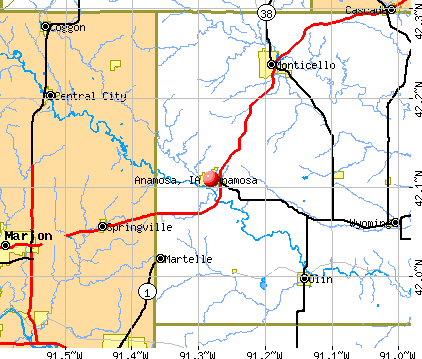
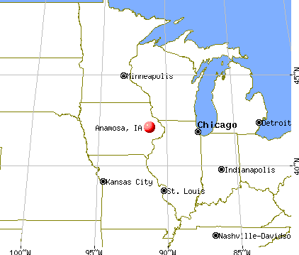
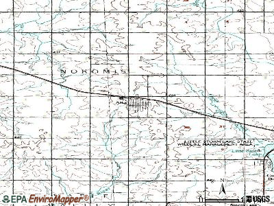
Anamosa, Iowa

Anamosa: State of Iowa Department of Corrections: Anamosa State Penitentiary
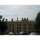
Anamosa: State of Iowa Department of Corrections: Anamosa State Penitentiary
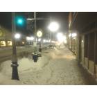
Anamosa: Downtown Winter Nights
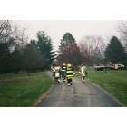
Anamosa: Anamosa Fire Department at a fire
- add
your
Submit your own pictures of this city and show them to the world
- OSM Map
- General Map
- Google Map
- MSN Map
Population change since 2000: +0.5%
 |
| Males: 3,023 | |
| Females: 2,498 |
| Median resident age: | 42.5 years |
| Iowa median age: | 38.9 years |
Zip codes: 52205.
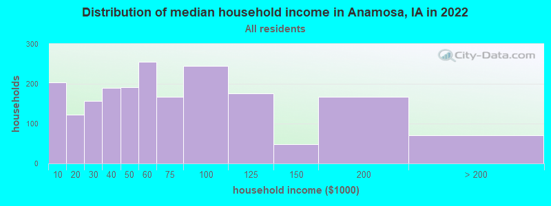
| Anamosa: | $55,155 |
| IA: | $69,588 |
Estimated per capita income in 2022: $28,721 (it was $18,585 in 2000)
Anamosa city income, earnings, and wages data
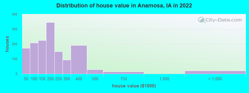
Estimated median house or condo value in 2022: $172,204 (it was $72,400 in 2000)
| Anamosa: | $172,204 |
| IA: | $194,600 |
Median gross rent in 2022: $739.
(19.4% for White Non-Hispanic residents, 77.3% for Hispanic or Latino residents, 76.7% for other race residents, 1.1% for two or more races residents)
Detailed information about poverty and poor residents in Anamosa, IA
Compare current foreclosures near Anamosa, IA:
| Photo | Address | Area | Beds / Baths | Price | Details |
|---|---|---|---|---|---|

|
#1
N Ford St
Anamosa, IA 52205
|
- sq. feet
|
- baths - beds |
show details | |

|
#2
Linn Ct
Anamosa, IA 52205
|
- sq. feet
|
- baths - beds |
show details | |

|
#3
Sunset Ct
Anamosa, IA 52205
|
- sq. feet
|
- baths - beds |
show details | |

|
#4
Buffalo Rd
Anamosa, IA 52205
|
- sq. feet
|
- baths - beds |
show details | |

|
#5
Bolton St
Springville, IA 52336
|
1,354 sq. feet
|
1 baths 2 beds |
show details | |

|
#6
4th Ave SW
Mount Vernon, IA 52314
|
720 sq. feet
|
1 baths 2 beds |
show details | |

|
#7
Pleasantview Dr
Marion, IA 52302
|
1,962 sq. feet
|
3 baths 3 beds |
show details | |

|
#8
14th St
Marion, IA 52302
|
1,858 sq. feet
|
2 baths 3 beds |
show details | |

|
#9
Emerald St
Marion, IA 52302
|
2,255 sq. feet
|
3 baths 5 beds |
show details | |

|
#10
25th St
Marion, IA 52302
|
960 sq. feet
|
1 baths 3 beds |
show details |
| Photo | Address | Area | Beds / Baths | Price | Details |
|---|---|---|---|---|---|

|
#11
14th Ave
Marion, IA 52302
|
1,750 sq. feet
|
1 baths 3 beds |
show details | |

|
#12
31st St
Marion, IA 52302
|
1,629 sq. feet
|
2 baths 3 beds |
show details | |

|
#13
28th Ave
Marion, IA 52302
|
1,580 sq. feet
|
2 baths 3 beds |
show details | |

|
#14
49th Street Ct
Marion, IA 52302
|
1,479 sq. feet
|
2 baths 2 beds |
show details | |

|
#15
Magnolia Ln Unit 4
Marion, IA 52302
|
1,374 sq. feet
|
1 baths 2 beds |
show details | |

|
#16
Grove St
Central City, IA 52214
|
3,121 sq. feet
|
4 baths 3 beds |
show details | |

|
#17
River St S
Central City, IA 52214
|
1,959 sq. feet
|
2 baths 3 beds |
show details | |

|
#18
Hoosier Rd
Lisbon, IA 52253
|
2,704 sq. feet
|
2 baths 3 beds |
show details | |

|
#19
Commercial St
Central City, IA 52214
|
1,404 sq. feet
|
3 baths 3 beds |
show details | |

|
#20
Vasey Ave Apt 3
Marion, IA 52302
|
- sq. feet
|
- baths - beds |
show details |
| Photo | Address | Area | Beds / Baths | Price | Details |
|---|---|---|---|---|---|

|
#21
Hemingway St
Marion, IA 52302
|
- sq. feet
|
- baths - beds |
show details | |

|
#22
Highway 151 Apt 305
Marion, IA 52302
|
- sq. feet
|
- baths - beds |
show details | |

|
#23
Prairie Bend Cir
Marion, IA 52302
|
1,166 sq. feet
|
- baths - beds |
show details | |

|
#24
English Glen Ct Unit 6
Marion, IA 52302
|
- sq. feet
|
- baths - beds |
show details | |

|
#25
Galway Dr
Marion, IA 52302
|
- sq. feet
|
- baths - beds |
show details | |

|
#26
E Kacena Ave
Marion, IA 52302
|
1,318 sq. feet
|
- baths - beds |
show details | |

|
#27
Highway 30 SW Apt 2
Mount Vernon, IA 52314
|
- sq. feet
|
- baths - beds |
show details | |

|
#28
Chapelridge Cir
Marion, IA 52302
|
- sq. feet
|
- baths - beds |
show details | |

|
#29
Galway Dr
Marion, IA 52302
|
- sq. feet
|
- baths - beds |
show details | |

|
#30
9th St Apt 2
Marion, IA 52302
|
- sq. feet
|
- baths - beds |
show details |
| Photo | Address | Area | Beds / Baths | Price | Details |
|---|---|---|---|---|---|

|
#31
County Road X31
Monticello, IA 52310
|
- sq. feet
|
- baths - beds |
show details | |

|
#32
Sundance Dr
Marion, IA 52302
|
- sq. feet
|
- baths - beds |
show details | |

|
#33
148th St
Monticello, IA 52310
|
- sq. feet
|
- baths - beds |
show details | |

|
#34
County Road X31
Monticello, IA 52310
|
- sq. feet
|
- baths - beds |
show details | |

|
#35
Ottawa Dr
Marion, IA 52302
|
- sq. feet
|
- baths - beds |
show details | |

|
Check over 1 million property listings on Foreclosure.com!
|
browse all offers | |||


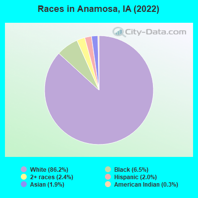
- 4,75186.2%White alone
- 3566.5%Black alone
- 1352.4%Two or more races
- 1132.0%Hispanic
- 1061.9%Asian alone
- 140.3%American Indian alone
Races in Anamosa detailed stats: ancestries, foreign born residents, place of birth
According to our research of Iowa and other state lists, there were 9 registered sex offenders living in Anamosa, Iowa as of April 27, 2024.
The ratio of all residents to sex offenders in Anamosa is 612 to 1.
The ratio of registered sex offenders to all residents in this city is lower than the state average.
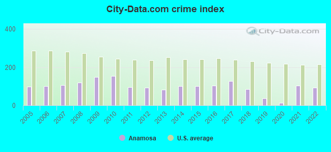
Type |
2009 |
2010 |
2011 |
2012 |
2013 |
2014 |
2015 |
2016 |
2017 |
2018 |
2019 |
2020 |
2021 |
2022 |
|---|---|---|---|---|---|---|---|---|---|---|---|---|---|---|
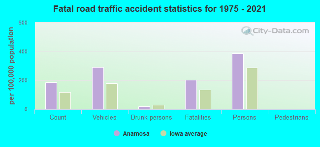
| Murders (per 100,000) | 0 (0.0) | 0 (0.0) | 0 (0.0) | 0 (0.0) | 0 (0.0) | 0 (0.0) | 0 (0.0) | 0 (0.0) | 0 (0.0) | 0 (0.0) | 0 (0.0) | 0 (0.0) | 0 (0.0) | 0 (0.0) |
| Rapes (per 100,000) | 0 (0.0) | 1 (18.1) | 0 (0.0) | 0 (0.0) | 0 (0.0) | 1 (18.0) | 1 (18.5) | 0 (0.0) | 0 (0.0) | 1 (18.6) | 0 (0.0) | 1 (18.1) | 0 (0.0) | 3 (55.4) |
| Robberies (per 100,000) | 0 (0.0) | 1 (18.1) | 0 (0.0) | 0 (0.0) | 0 (0.0) | 0 (0.0) | 0 (0.0) | 0 (0.0) | 0 (0.0) | 0 (0.0) | 0 (0.0) | 0 (0.0) | 1 (18.0) | 0 (0.0) |
| Assaults (per 100,000) | 6 (104.1) | 4 (72.3) | 5 (89.9) | 3 (54.1) | 2 (35.4) | 6 (108.2) | 4 (74.1) | 10 (183.4) | 11 (203.3) | 3 (55.9) | 6 (109.1) | 0 (0.0) | 15 (270.5) | 8 (147.8) |
| Burglaries (per 100,000) | 26 (451.1) | 58 (1,048) | 29 (521.4) | 27 (486.7) | 15 (265.3) | 16 (288.6) | 18 (333.6) | 19 (348.4) | 19 (351.1) | 10 (186.3) | 0 (0.0) | 0 (0.0) | 10 (180.3) | 5 (92.4) |
| Thefts (per 100,000) | 131 (2,273) | 61 (1,102) | 58 (1,043) | 61 (1,100) | 77 (1,362) | 60 (1,082) | 51 (945.3) | 50 (916.8) | 77 (1,423) | 54 (1,006) | 20 (363.5) | 0 (0.0) | 32 (577.1) | 13 (240.3) |
| Auto thefts (per 100,000) | 5 (86.7) | 2 (36.1) | 0 (0.0) | 2 (36.1) | 2 (35.4) | 2 (36.1) | 6 (111.2) | 4 (73.3) | 3 (55.4) | 3 (55.9) | 1 (18.2) | 0 (0.0) | 6 (108.2) | 3 (55.4) |
| Arson (per 100,000) | 1 (17.3) | 1 (18.1) | 0 (0.0) | 0 (0.0) | 0 (0.0) | 1 (18.0) | 0 (0.0) | 0 (0.0) | 0 (0.0) | 0 (0.0) | 0 (0.0) | 0 (0.0) | 0 (0.0) | 1 (18.5) |
| City-Data.com crime index | 150.2 | 154.7 | 96.2 | 91.8 | 83.0 | 102.5 | 99.7 | 103.6 | 126.6 | 83.8 | 37.8 | 14.5 | 103.9 | 94.4 |
The City-Data.com crime index weighs serious crimes and violent crimes more heavily. Higher means more crime, U.S. average is 246.1. It adjusts for the number of visitors and daily workers commuting into cities.
Crime rate in Anamosa detailed stats: murders, rapes, robberies, assaults, burglaries, thefts, arson
Full-time law enforcement employees in 2021, including police officers: 9 (8 officers - 7 male; 1 female).
| Officers per 1,000 residents here: | 1.44 |
| Iowa average: | 1.76 |
 Recent articles from our blog. Our writers, many of them Ph.D. graduates or candidates, create easy-to-read articles on a wide variety of topics.

 | John Wayne Gacy & others that have ties to Iowa (2 replies) |
| Dream town in Iowa (34 replies) |
| Decorah and Winneshiek County Area Feedback (8 replies) |
| Good day or weekend trips in Iowa? (11 replies) |
| Good town to raise a family near Dubuque? (10 replies) |
| DON'T LAUGH.......Considering a vacation to Iowa! (88 replies) |
Latest news from Anamosa, IA collected exclusively by city-data.com from local newspapers, TV, and radio stations
Ancestries: German (40.3%), Scottish (7.3%), American (5.5%), Irish (4.0%), English (3.7%), Norwegian (2.8%).
Current Local Time: CST time zone
Incorporated on 12/17/1867
Elevation: 840 feet
Land area: 2.24 square miles.
Population density: 2,465 people per square mile (low).
118 residents are foreign born (1.5% Asia, 0.5% Latin America).
| This city: | 2.1% |
| Iowa: | 5.6% |
Median real estate property taxes paid for housing units with mortgages in 2022: $2,817 (1.5%)
Median real estate property taxes paid for housing units with no mortgage in 2022: $2,081 (1.6%)
Nearest city with pop. 50,000+: Cedar Rapids, IA  (21.7 miles , pop. 120,758).
Nearest city with pop. 200,000+: Madison, WI (117.0 miles , pop. 208,054).
Nearest city with pop. 1,000,000+: Chicago, IL (186.1 miles , pop. 2,896,016).
Nearest cities:
), ), ), Latitude: 42.11 N, Longitude: 91.28 W
Area code: 319
Anamosa, Iowa accommodation & food services, waste management - Economy and Business Data
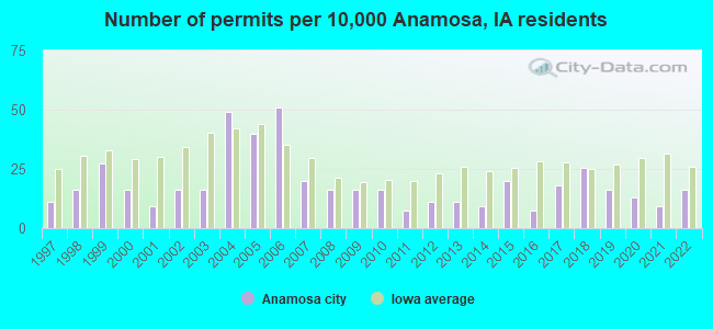
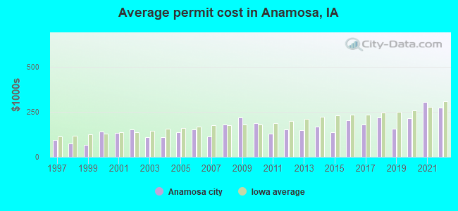
Single-family new house construction building permits:
- 2022: 9 buildings, average cost: $272,200
- 2021: 5 buildings, average cost: $304,600
- 2020: 7 buildings, average cost: $214,300
- 2019: 9 buildings, average cost: $156,200
- 2018: 14 buildings, average cost: $216,800
- 2017: 10 buildings, average cost: $177,900
- 2016: 4 buildings, average cost: $201,300
- 2015: 11 buildings, average cost: $137,500
- 2014: 5 buildings, average cost: $166,000
- 2013: 6 buildings, average cost: $149,800
- 2012: 6 buildings, average cost: $153,300
- 2011: 4 buildings, average cost: $129,300
- 2010: 9 buildings, average cost: $189,400
- 2009: 9 buildings, average cost: $216,700
- 2008: 9 buildings, average cost: $181,100
- 2007: 11 buildings, average cost: $111,700
- 2006: 28 buildings, average cost: $152,600
- 2005: 22 buildings, average cost: $136,600
- 2004: 27 buildings, average cost: $108,300
- 2003: 9 buildings, average cost: $111,100
- 2002: 9 buildings, average cost: $150,600
- 2001: 5 buildings, average cost: $133,000
- 2000: 9 buildings, average cost: $142,300
- 1999: 15 buildings, average cost: $68,200
- 1998: 9 buildings, average cost: $72,800
- 1997: 6 buildings, average cost: $91,800
| Here: | 3.2% |
| Iowa: | 2.7% |
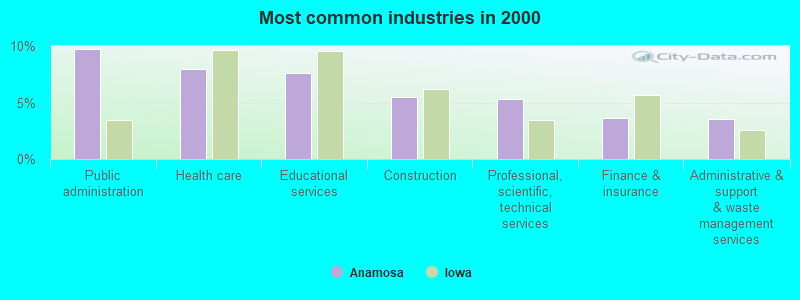
- Public administration (9.8%)
- Health care (7.9%)
- Educational services (7.6%)
- Construction (5.5%)
- Professional, scientific, technical services (5.3%)
- Finance & insurance (3.6%)
- Administrative & support & waste management services (3.5%)
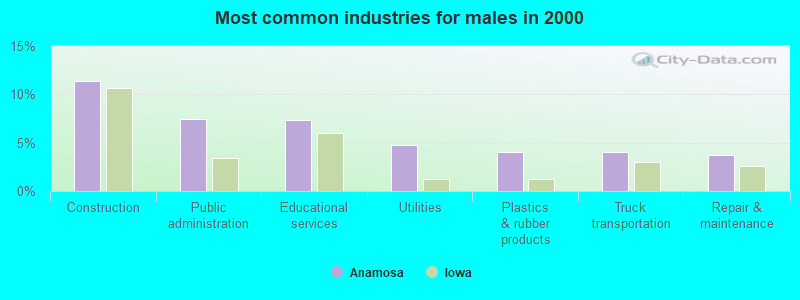
- Construction (11.4%)
- Public administration (7.4%)
- Educational services (7.3%)
- Utilities (4.7%)
- Plastics & rubber products (4.1%)
- Truck transportation (4.1%)
- Repair & maintenance (3.8%)
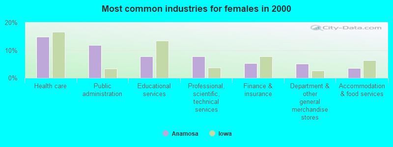
- Health care (14.8%)
- Public administration (11.9%)
- Educational services (7.9%)
- Professional, scientific, technical services (7.9%)
- Finance & insurance (5.4%)
- Department & other general merchandise stores (5.2%)
- Accommodation & food services (3.5%)
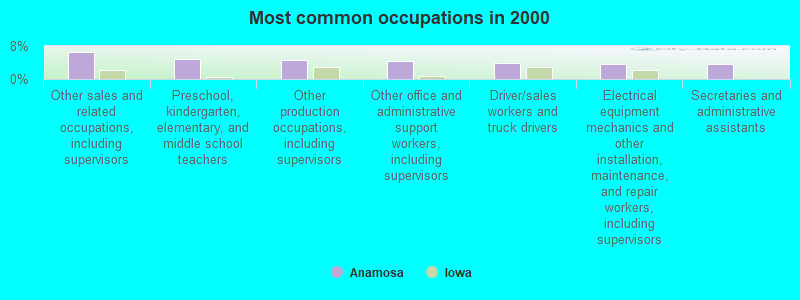
- Other sales and related occupations, including supervisors (6.6%)
- Preschool, kindergarten, elementary, and middle school teachers (4.7%)
- Other production occupations, including supervisors (4.5%)
- Other office and administrative support workers, including supervisors (4.3%)
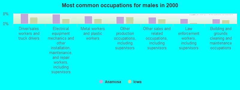
- Driver/sales workers and truck drivers (3.9%)
- Electrical equipment mechanics and other installation, maintenance, and repair workers, including supervisors (3.7%)
- Secretaries and administrative assistants (3.5%)
- Driver/sales workers and truck drivers (8.0%)
- Electrical equipment mechanics and other installation, maintenance, and repair workers, including supervisors (7.7%)
- Metal workers and plastic workers (6.2%)
- Other production occupations, including supervisors (5.7%)
- Other sales and related occupations, including supervisors (5.2%)
- Law enforcement workers, including supervisors (4.1%)
- Building and grounds cleaning and maintenance occupations (3.8%)
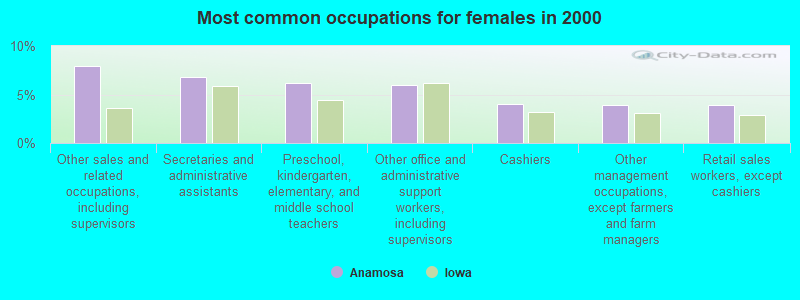
- Other sales and related occupations, including supervisors (8.0%)
- Secretaries and administrative assistants (6.8%)
- Preschool, kindergarten, elementary, and middle school teachers (6.2%)
- Other office and administrative support workers, including supervisors (6.0%)
- Cashiers (4.0%)
- Other management occupations, except farmers and farm managers (3.9%)
- Retail sales workers, except cashiers (3.9%)
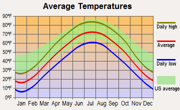
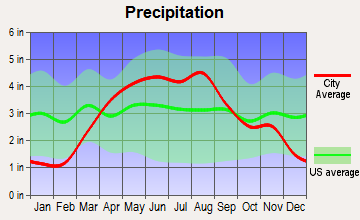
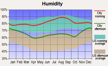
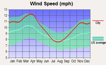
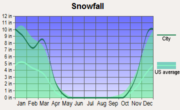
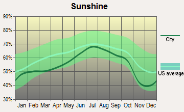
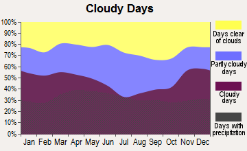
Average climate in Anamosa, Iowa
Based on data reported by over 4,000 weather stations
|
|

(lower is better)
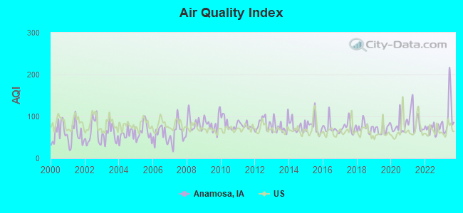
Air Quality Index (AQI) level in 2023 was 103. This is significantly worse than average.
| City: | 103 |
| U.S.: | 73 |
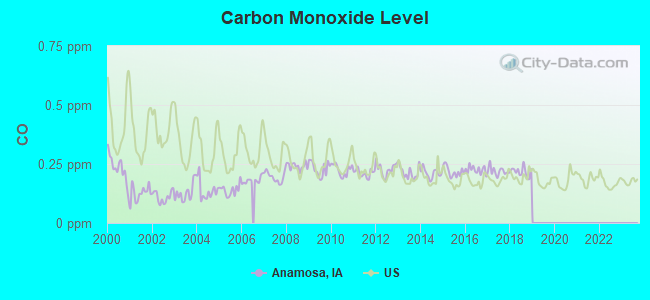
Carbon Monoxide (CO) [ppm] level in 2018 was 0.217. This is about average. Closest monitor was 21.2 miles away from the city center.
| City: | 0.217 |
| U.S.: | 0.251 |
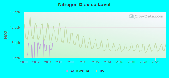
Nitrogen Dioxide (NO2) [ppb] level in 2004 was 3.43. This is significantly better than average. Closest monitor was 14.2 miles away from the city center.
| City: | 3.43 |
| U.S.: | 5.11 |
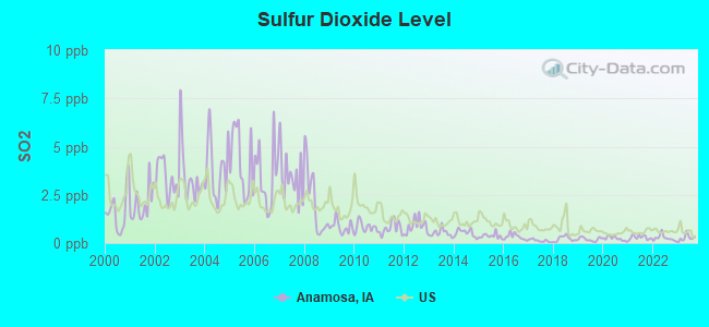
Sulfur Dioxide (SO2) [ppb] level in 2023 was 0.268. This is significantly better than average. Closest monitor was 19.5 miles away from the city center.
| City: | 0.268 |
| U.S.: | 1.515 |
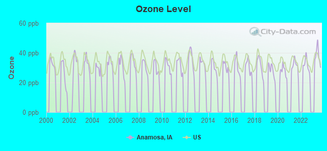
Ozone [ppb] level in 2023 was 38.0. This is about average. Closest monitor was 13.7 miles away from the city center.
| City: | 38.0 |
| U.S.: | 33.3 |
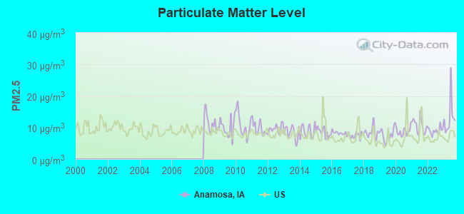
Particulate Matter (PM2.5) [µg/m3] level in 2023 was 13.2. This is significantly worse than average. Closest monitor was 19.9 miles away from the city center.
| City: | 13.2 |
| U.S.: | 8.1 |
Tornado activity:
Anamosa-area historical tornado activity is near Iowa state average. It is 96% greater than the overall U.S. average.
On 3/13/1990, a category F4 (max. wind speeds 207-260 mph) tornado 11.0 miles away from the Anamosa city center caused between $5,000,000 and $50,000,000 in damages.
On 8/12/1974, a category F4 tornado 19.5 miles away from the city center injured 12 people and caused between $500,000 and $5,000,000 in damages.
Earthquake activity:
Anamosa-area historical earthquake activity is significantly above Iowa state average. It is 119% greater than the overall U.S. average.On 4/18/2008 at 09:36:59, a magnitude 5.4 (5.1 MB, 4.8 MS, 5.4 MW, 5.2 MW, Class: Moderate, Intensity: VI - VII) earthquake occurred 309.9 miles away from the city center
On 6/10/1987 at 23:48:54, a magnitude 5.1 (4.9 MB, 4.4 MS, 4.6 MS, 5.1 LG) earthquake occurred 289.2 miles away from Anamosa center
On 4/18/2008 at 09:36:59, a magnitude 5.2 (5.2 MW, Depth: 8.9 mi) earthquake occurred 309.9 miles away from the city center
On 6/28/2004 at 06:10:52, a magnitude 4.2 (4.2 MW, Depth: 6.2 mi, Class: Light, Intensity: IV - V) earthquake occurred 130.8 miles away from the city center
On 6/18/2002 at 17:37:15, a magnitude 5.0 (4.3 MB, 4.6 MW, 5.0 LG) earthquake occurred 340.0 miles away from Anamosa center
On 4/18/2008 at 15:14:16, a magnitude 4.8 (4.5 MB, 4.8 MW, 4.6 MW) earthquake occurred 309.7 miles away from the city center
Magnitude types: regional Lg-wave magnitude (LG), body-wave magnitude (MB), surface-wave magnitude (MS), moment magnitude (MW)
Natural disasters:
The number of natural disasters in Jones County (21) is greater than the US average (15).Major Disasters (Presidential) Declared: 18
Emergencies Declared: 1
Causes of natural disasters: Floods: 16, Storms: 15, Tornadoes: 7, Heavy Rains: 2, Winter Storms: 2, Hurricane: 1, Wind: 1, Other: 1 (Note: some incidents may be assigned to more than one category).
Hospitals and medical centers in Anamosa:
- JONES REGIONAL MEDICAL CENTER (Voluntary non-profit - Private, provides emergency services, 1795 HIGHWAY 64 EAST)
- ANAMOSA CARE CENTER (1209 EAST THIRD STREET)
Other hospitals and medical centers near Anamosa:
Heliports located in Anamosa:
College/University in Anamosa:
Colleges/universities with over 2000 students nearest to Anamosa:
- Kirkwood Community College (about 24 miles; Cedar Rapids, IA; Full-time enrollment: 11,503)
- University of Iowa (about 34 miles; Iowa City, IA; FT enrollment: 24,735)
- Saint Ambrose University (about 54 miles; Davenport, IA; FT enrollment: 3,053)
- Kaplan University-Davenport Campus (about 54 miles; Davenport, IA; FT enrollment: 60,376)
- Eastern Iowa Community College District (about 55 miles; Davenport, IA; FT enrollment: 5,507)
- Augustana College (about 57 miles; Rock Island, IL; FT enrollment: 2,555)
- Upper Iowa University (about 58 miles; Fayette, IA; FT enrollment: 5,275)
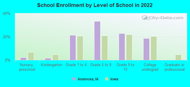
Public high school in Anamosa:
- ANAMOSA HIGH SCHOOL (Students: 448, Location: 209 SADIE ST, Grades: 9-12)
Public elementary/middle schools in Anamosa:
- STRAWBERRY HILL (Students: 539, Location: 203 HAMILTON COURT, Grades: PK-4)
- ANAMOSA MIDDLE SCHOOL (Location: 410 OLD DUBUQUE ROAD, Grades: 5-8)
Private elementary/middle school in Anamosa:
- ST PATRICK SCHOOL (Students: 80, Location: 216 N GARNAVILLO ST, Grades: PK-6)
Points of interest:
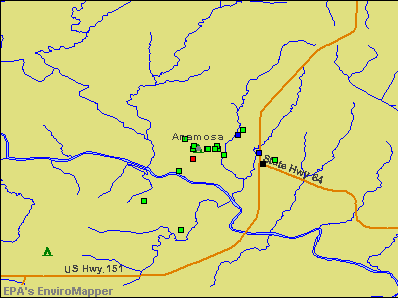
Notable locations in Anamosa: Anamosa State Penitentiary - Men's Reformatory (A), Jones County Jail (B), Jones County Courthouse (C), Anamosa Penitentiary Museum (D), Jones County Sheriffs Office (E), Anamosa Public Library (F), National Motorcycle Museum (G), Anamosa Police Department (H), Anamosa City Fire Department (I), Anamosa Area Ambulance Service (J), Anamosa City Hall (K). Display/hide their locations on the map
Churches in Anamosa include: Saint Patricks Church (A), Saint Marks Episcopal Church (B), United Methodist Church (C), First Congregational Church (D), Saint Pauls Lutheran Church (E), Anamosa Congregation - Jehovahs Witnesses (F), First Baptist Church (G), Calvary Foursquare Church (H), Apostolic Assembly of Anamoose (I). Display/hide their locations on the map
Cemeteries: Riverside Cemetery (1), Holy Cross Cemetery (2). Display/hide their locations on the map
Creek: Buffalo Creek (A). Display/hide its location on the map
Parks in Anamosa include: Old Military Road Historical Marker (1), Gideon Ford Home Site Historical Marker (2). Display/hide their locations on the map
Tourist attractions: Anamosa State Penitentary Museum (406 North High Street), Grant Wood Art Gallery (124 East Main Street).
Hotel: Anamosa Super 8 Motel (100 Grant Wood Drive).
Courts: Jones County - Bailiff- Court Attendant (Court House), Jones County - Juvenile Court Office (Court House), Jones County - Court Room (Court House), Jones County - Magistrate Court (Court House).
Birthplace of: Grant Wood - Painter, Jack Evans (musician) - Rock musician, Marshal Yanda - Football player, Nan Wood Graham - Artist's model, Peggy Wilson - Alaskan politician.
Drinking water stations with addresses in Anamosa and their reported violations in the past:
ANAMOSA MUNICIPAL WATER SUPPLY (Address: 107 S FORD , Population served: 4,283, Groundwater):Past health violations:ANAMOSA STATE PENITENTIARY (Population served: 1,725, Groundwater):Past monitoring violations:
- MCL, Average - Between APR-2007 and JUN-2007, Contaminant: Combined Radium (-226 and -228). Follow-up actions: St BCA signed (APR-19-2007), St Formal NOV issued (MAY-23-2007), St Public Notif requested (MAY-23-2007), St Public Notif received (MAY-31-2007), St Compliance achieved (OCT-27-2008)
- MCL, Average - Between JAN-2007 and MAR-2007, Contaminant: Combined Radium (-226 and -228). Follow-up actions: St Formal NOV issued (MAR-01-2007), St Public Notif requested (MAR-01-2007), St Public Notif received (MAR-13-2007), St Compliance achieved (OCT-27-2008)
- MCL, Average - Between OCT-2006 and DEC-2006, Contaminant: Combined Radium (-226 and -228). Follow-up actions: St Formal NOV issued (NOV-16-2006), St Public Notif requested (NOV-16-2006), St Public Notif received (JAN-03-2007), St Compliance achieved (OCT-27-2008)
- 4 regular monitoring violations
Past health violations:WAPSIPINICON STATE PK-CAMPGROUND/LODGE (Address: 21301 COUNTY RD E34 , Population served: 150, Groundwater):Past monitoring violations:
- MCL, Average - Between JAN-2011 and DEC-2011, Contaminant: Combined Radium (-226 and -228). Follow-up actions: St Formal NOV issued (DEC-07-2011), St Public Notif requested (DEC-07-2011), St Compliance achieved (DEC-16-2011), St Public Notif received (JAN-04-2012)
- Follow-up Or Routine LCR Tap M/R - In JAN-01-2012, Contaminant: Lead and Copper Rule. Follow-up actions: St Formal NOV issued (FEB-16-2012), St Public Notif requested (FEB-16-2012), St Compliance achieved (FEB-21-2012), St Public Notif received (JUN-06-2012)
Past health violations:SCOOTERS (Population served: 125, Groundwater):Past monitoring violations:
- MCL, Monthly (TCR) - In JUL-2011, Contaminant: Coliform. Follow-up actions: St Violation/Reminder Notice (JUL-18-2011), St Public Notif requested (JUL-20-2011), St Formal NOV issued (JUL-20-2011), St Public Notif received (AUG-15-2011), St Compliance achieved (OCT-10-2011)
- MCL, Monthly (TCR) - In OCT-2007, Contaminant: Coliform. Follow-up actions: St Violation/Reminder Notice (OCT-12-2007), St Public Notif requested (OCT-22-2007), St Formal NOV issued (OCT-22-2007), St Public Notif received (APR-15-2008), St Compliance achieved (JUN-15-2009)
- MCL, Monthly (TCR) - In JUL-2007, Contaminant: Coliform. Follow-up actions: St Violation/Reminder Notice (JUL-12-2007), St Public Notif requested (JUL-16-2007), St Formal NOV issued (JUL-16-2007), St Public Notif received (JUL-26-2007), St Compliance achieved (JUN-15-2009)
- One minor monitoring violation
Past monitoring violations:STONE CITY GENERAL STORE PUB (Address: 12612 STONE CITY RD , Population served: 108, Groundwater):
- 8 routine major monitoring violations
- 4 regular monitoring violations
Past monitoring violations:WAPSIPINICON COUNTRY CLUB (Population served: 85, Groundwater):
- One routine major monitoring violation
- One minor monitoring violation
- 2 regular monitoring violations
Past health violations:Past monitoring violations:
- MCL, Monthly (TCR) - In MAR-2010, Contaminant: Coliform. Follow-up actions: St BCA signed (NOV-21-2008), St Violation/Reminder Notice (APR-01-2010), St Public Notif requested (APR-05-2010), St Formal NOV issued (APR-05-2010), St Public Notif received (APR-23-2010), St Compliance achieved (SEP-28-2010)
- MCL, Monthly (TCR) - In JAN-2010, Contaminant: Coliform. Follow-up actions: St BCA signed (NOV-21-2008), St Violation/Reminder Notice (JAN-13-2010), St Formal NOV issued (JAN-20-2010), St Public Notif requested (JAN-20-2010), St Public Notif received (MAY-07-2010), St Compliance achieved (SEP-28-2010)
- MCL, Monthly (TCR) - In DEC-2009, Contaminant: Coliform. Follow-up actions: St BCA signed (NOV-21-2008), St Formal NOV issued (DEC-30-2009), St Public Notif requested (DEC-30-2009), St Public Notif received (MAY-07-2010), St Compliance achieved (SEP-28-2010)
- MCL, Monthly (TCR) - In JUL-2009, Contaminant: Coliform. Follow-up actions: St BCA signed (NOV-21-2008), St Public Notif requested (JUL-29-2009), St Formal NOV issued (JUL-29-2009), St Public Notif received (MAY-07-2010), St Compliance achieved (SEP-28-2010)
- MCL, Monthly (TCR) - In JUN-2009, Contaminant: Coliform. Follow-up actions: St BCA signed (NOV-21-2008), St Violation/Reminder Notice (JUN-05-2009), St Public Notif requested (JUL-02-2009), St Formal NOV issued (JUL-02-2009), St Public Notif received (MAY-07-2010), St Compliance achieved (SEP-28-2010)
- MCL, Monthly (TCR) - In JUN-2008, Contaminant: Coliform. Follow-up actions: St Violation/Reminder Notice (JUN-12-2008), St Formal NOV issued (JUN-23-2008), St Public Notif requested (JUN-23-2008), St Public Notif received (MAY-07-2010), St Compliance achieved (SEP-28-2010)
- MCL, Monthly (TCR) - Between APR-2008 and JUN-2008, Contaminant: Coliform. Follow-up actions: St Violation/Reminder Notice (MAY-22-2008), St Public Notif requested (MAY-27-2008), St Formal NOV issued (MAY-27-2008), St BCA signed (NOV-21-2008), St Public Notif received (MAY-07-2010), St Compliance achieved (SEP-28-2010)
- Monitoring, Repeat Major (TCR) - Between AUG-2008 and SEP-2008, Contaminant: Coliform (TCR). Follow-up actions: St Public Notif requested (SEP-16-2008), St Formal NOV issued (SEP-16-2008), St Compliance achieved (OCT-02-2008), St BCA signed (NOV-21-2008), St Public Notif received (MAY-07-2010)
- Monitoring, Repeat Major (TCR) - Between JUN-2008 and JUL-2008, Contaminant: Coliform (TCR). Follow-up actions: St Public Notif requested (AUG-07-2008), St Formal NOV issued (AUG-07-2008), St Compliance achieved (OCT-02-2008), St BCA signed (NOV-21-2008), St Public Notif received (MAY-07-2010)
- 9 routine major monitoring violations
- 3 minor monitoring violations
| This city: | 2.2 people |
| Iowa: | 2.4 people |
| This city: | 59.9% |
| Whole state: | 64.7% |
| This city: | 8.1% |
| Whole state: | 6.7% |
Likely homosexual households (counted as self-reported same-sex unmarried-partner households)
- Lesbian couples: 0.3% of all households
- Gay men: 0.2% of all households
People in group quarters in Anamosa in 2010:
- 1,043 people in state prisons
- 114 people in nursing facilities/skilled-nursing facilities
- 7 people in local jails and other municipal confinement facilities
People in group quarters in Anamosa in 2000:
- 1,303 people in state prisons
- 71 people in nursing homes
- 14 people in local jails and other confinement facilities (including police lockups)
Banks with branches in Anamosa (2011 data):
- Farmers & Merchants Savings Bank: Bra at 220 West Main Street, branch established on 2004/11/01. Info updated 2011/01/06: Bank assets: $336.5 mil, Deposits: $278.7 mil, headquarters in Manchester, IA, positive income, Commercial Lending Specialization, 6 total offices, Holding Company: Dunn Investment Co.
- Fidelity Bank & Trust: Security State Bank Branch at 107 South Garnavillo Street, branch established on 1886/04/01. Info updated 2011/07/27: Bank assets: $560.1 mil, Deposits: $452.8 mil, headquarters in Dubuque, IA, positive income, Agricultural Specialization, 18 total offices, Holding Company: Fidelity Company
- Citizens Savings Bank: at 215 East Main Street, branch established on 1906/11/08. Info updated 2006/11/03: Bank assets: $115.8 mil, Deposits: $102.6 mil, local headquarters, positive income, Agricultural Specialization, 2 total offices, Holding Company: First Community Bancshares Corp.
For population 15 years and over in Anamosa:
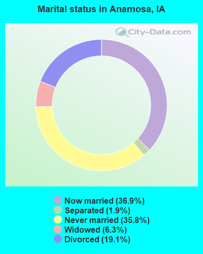
- Never married: 35.8%
- Now married: 36.9%
- Separated: 1.9%
- Widowed: 6.3%
- Divorced: 19.1%
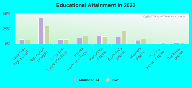
For population 25 years and over in Anamosa:
- High school or higher: 91.4%
- Bachelor's degree or higher: 18.3%
- Graduate or professional degree: 7.6%
- Unemployed: 3.6%
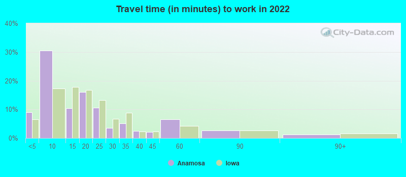
- Mean travel time to work (commute): 26.5 minutes
| Here: | 9.6 |
| Iowa average: | 10.5 |
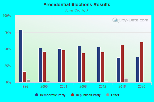
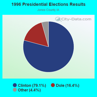
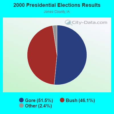
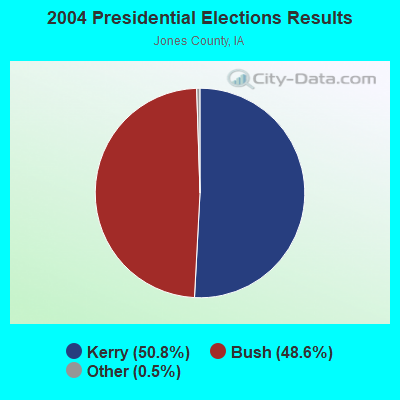
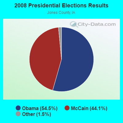

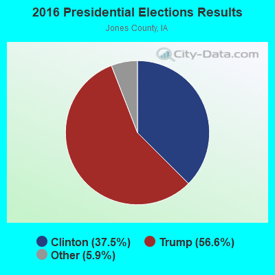
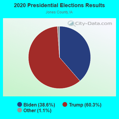
Graphs represent county-level data. Detailed 2008 Election Results
Religion statistics for Anamosa, IA (based on Jones County data)
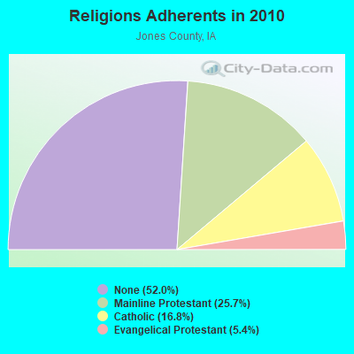
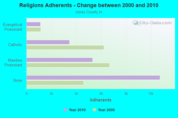
| Religion | Adherents | Congregations |
|---|---|---|
| Mainline Protestant | 5,308 | 22 |
| Catholic | 3,463 | 4 |
| Evangelical Protestant | 1,122 | 9 |
| Other | 7 | 1 |
| None | 10,738 | - |
Food Environment Statistics:
| Jones County: | 2.46 / 10,000 pop. |
| Iowa: | 2.14 / 10,000 pop. |
| Jones County: | 7.37 / 10,000 pop. |
| State: | 5.55 / 10,000 pop. |
| Here: | 6.88 / 10,000 pop. |
| State: | 8.01 / 10,000 pop. |
| This county: | 7.5% |
| Iowa: | 7.8% |
| Jones County: | 27.0% |
| Iowa: | 27.3% |
| This county: | 13.0% |
| State: | 14.5% |
Health and Nutrition:
| Anamosa: | 48.1% |
| Iowa: | 49.5% |
| Anamosa: | 43.2% |
| Iowa: | 46.1% |
| Anamosa: | 29.1 |
| Iowa: | 28.6 |
| Here: | 20.1% |
| Iowa: | 21.4% |
| Anamosa: | 12.1% |
| Iowa: | 10.4% |
| Anamosa: | 6.8 |
| Iowa: | 6.8 |
| Anamosa: | 31.5% |
| State: | 33.8% |
| Anamosa: | 55.8% |
| Iowa: | 55.9% |
| Anamosa: | 77.6% |
| Iowa: | 77.7% |
More about Health and Nutrition of Anamosa, IA Residents
| Local government employment and payroll (March 2022) | |||||
| Function | Full-time employees | Monthly full-time payroll | Average yearly full-time wage | Part-time employees | Monthly part-time payroll |
|---|---|---|---|---|---|
| Police Protection - Officers | 8 | $38,194 | $57,291 | 0 | $0 |
| Streets and Highways | 5 | $19,787 | $47,489 | 2 | $5,494 |
| Sewerage | 4 | $15,199 | $45,597 | 0 | $0 |
| Other Government Administration | 4 | $11,215 | $33,645 | 7 | $1,232 |
| Parks and Recreation | 3 | $18,747 | $74,988 | 9 | $4,353 |
| Water Supply | 2 | $8,122 | $48,732 | 0 | $0 |
| Police - Other | 2 | $9,780 | $58,680 | 0 | $0 |
| Local Libraries | 2 | $11,255 | $67,530 | 5 | $5,604 |
| Financial Administration | 1 | $3,467 | $41,604 | 0 | $0 |
| Totals for Government | 31 | $135,766 | $52,555 | 23 | $16,682 |
Anamosa government finances - Expenditure in 2018 (per resident):
- Construction - Water Utilities: $3,420,000 ($619.45)
Regular Highways: $770,000 ($139.47)
Sewerage: $134,000 ($24.27)
- Current Operations - Sewerage: $1,032,000 ($186.92)
Regular Highways: $945,000 ($171.16)
Police Protection: $852,000 ($154.32)
Water Utilities: $735,000 ($133.13)
Parks and Recreation: $487,000 ($88.21)
Local Fire Protection: $366,000 ($66.29)
Libraries: $247,000 ($44.74)
Central Staff Services: $217,000 ($39.30)
Financial Administration: $133,000 ($24.09)
Housing and Community Development: $74,000 ($13.40)
General - Other: $71,000 ($12.86)
Solid Waste Management: $41,000 ($7.43)
Miscellaneous Commercial Activities - Other: $28,000 ($5.07)
General Public Buildings: $15,000 ($2.72)
Health - Other: $2,000 ($0.36)
- General - Interest on Debt: $76,000 ($13.77)
- Total Salaries and Wages: $1,508,000 ($273.14)
- Water Utilities - Interest on Debt: $37,000 ($6.70)
Anamosa government finances - Revenue in 2018 (per resident):
- Charges - Sewerage: $1,726,000 ($312.62)
Parks and Recreation: $98,000 ($17.75)
Other: $82,000 ($14.85)
Solid Waste Management: $53,000 ($9.60)
Miscellaneous Commercial Activities: $18,000 ($3.26)
- Federal Intergovernmental - Other: $447,000 ($80.96)
Housing and Community Development: $289,000 ($52.35)
- Local Intergovernmental - Other: $20,000 ($3.62)
- Miscellaneous - General Revenue - Other: $101,000 ($18.29)
Interest Earnings: $54,000 ($9.78)
Rents: $15,000 ($2.72)
Sale of Property: $11,000 ($1.99)
Fines and Forfeits: $6,000 ($1.09)
- Revenue - Water Utilities: $757,000 ($137.11)
- State Intergovernmental - Highways: $706,000 ($127.88)
Other: $91,000 ($16.48)
General Local Government Support: $45,000 ($8.15)
- Tax - Property: $1,854,000 ($335.81)
General Sales and Gross Receipts: $736,000 ($133.31)
Public Utilities Sales: $163,000 ($29.52)
Other Selective Sales: $85,000 ($15.40)
Other License: $45,000 ($8.15)
Anamosa government finances - Debt in 2018 (per resident):
- Long Term Debt - Outstanding Unspecified Public Purpose: $5,010,000 ($907.44)
Beginning Outstanding - Unspecified Public Purpose: $4,323,000 ($783.01)
Issue, Unspecified Public Purpose: $1,125,000 ($203.77)
Retired Unspecified Public Purpose: $438,000 ($79.33)
Anamosa government finances - Cash and Securities in 2018 (per resident):
- Other Funds - Cash and Securities: $9,779,000 ($1771.24)
- Sinking Funds - Cash and Securities: $597,000 ($108.13)
| Businesses in Anamosa, IA | ||||
| Name | Count | Name | Count | |
|---|---|---|---|---|
| AmericInn | 1 | McDonald's | 1 | |
| H&R Block | 1 | Subway | 2 | |
| Hardee's | 1 | Super 8 | 1 | |
| Lane Furniture | 1 | Walmart | 1 | |
Strongest AM radio stations in Anamosa:
- WMT (600 AM; 5 kW; CEDAR RAPIDS, IA; Owner: CITICASTERS LICENSES, L.P.)
- KCRG (1600 AM; 5 kW; CEDAR RAPIDS, IA; Owner: CEDAR RAPIDS TELEVISION CO.)
- KXEL (1540 AM; 50 kW; WATERLOO, IA; Owner: KXEL BROADCASTING COMPANY, INC.)
- KCJJ (1630 AM; 10 kW; IOWA CITY, IA; Owner: RIVER CITY RADIO, INC.)
- WHO (1040 AM; 50 kW; DES MOINES, IA; Owner: CITICASTERS LICENSES, L.P.)
- WSUI (910 AM; 5 kW; IOWA CITY, IA; Owner: THE UNIVERSITY OF IOWA)
- WTMJ (620 AM; 50 kW; MILWAUKEE, WI; Owner: JOURNAL BROADCAST CORPORATION)
- WSCR (670 AM; 50 kW; CHICAGO, IL; Owner: INFINITY BROADCASTING OPERATIONS, INC.)
- WGN (720 AM; 50 kW; CHICAGO, IL; Owner: WGN CONTINENTAL BROADCASTING CO.)
- WBBM (780 AM; 50 kW; CHICAGO, IL; Owner: INFINITY BROADCASTING OPERATIONS, INC.)
- KDTH (1370 AM; 5 kW; DUBUQUE, IA; Owner: RADIO DUBUQUE, INC.)
- KKHQ (950 AM; 5 kW; OELWEIN, IA; Owner: CUMULUS LICENSING CORP.)
- KCNZ (1250 AM; 10 kW; CEDAR FALLS, IA; Owner: FIFE COMMUNICATION COMPANY, L.C.)
Strongest FM radio stations in Anamosa:
- KDAT (104.5 FM; CEDAR RAPIDS, IA; Owner: CUMULUS LICENSING CORP.)
- KUNI (90.9 FM; CEDAR FALLS, IA; Owner: UNIVERSITY OF NORTHERN IOWA)
- KSUI (91.7 FM; IOWA CITY, IA; Owner: THE UNIVERSITY OF IOWA)
- KZIA (102.9 FM; CEDAR RAPIDS, IA; Owner: KZIA, INC.)
- KFMW (107.9 FM; WATERLOO, IA; Owner: KXEL BROADCASTING COMPANY, INC.)
- KOEL-FM (92.3 FM; OELWEIN, IA; Owner: CUMULUS LICENSING CORP.)
- WMT-FM (96.5 FM; CEDAR RAPIDS, IA; Owner: CITICASTERS LICENSES, L.P.)
- KOKZ (105.7 FM; WATERLOO, IA; Owner: KXEL BROADCASTING COMPANY, INC.)
- KHAK (98.1 FM; CEDAR RAPIDS, IA; Owner: CUMULUS LICENSING CORP.)
- KRNA (94.1 FM; IOWA CITY, IA; Owner: CUMULUS LICENSING CORP.)
- KNWS-FM (101.9 FM; WATERLOO, IA; Owner: NORTHWESTERN COLLEGE)
- KKRQ (100.7 FM; IOWA CITY, IA; Owner: CITICASTERS LICENSES, L.P.)
- KATF (92.9 FM; DUBUQUE, IA; Owner: RADIO DUBUQUE, INC.)
- KCCK-FM (88.3 FM; CEDAR RAPIDS, IA; Owner: KIRKWOOD COMMUNITY COLLEGE)
- KDST (99.3 FM; DYERSVILLE, IA; Owner: DESIGN HOMES, INC.)
- KRNL-FM (89.7 FM; MOUNT VERNON, IA; Owner: CORNELL COLLEGE)
TV broadcast stations around Anamosa:
- KFXA (Channel 28; CEDAR RAPIDS, IA; Owner: SECOND GENERATION OF IOWA, LTD.)
- KGAN (Channel 2; CEDAR RAPIDS, IA; Owner: KGAN LICENSEE, LLC)
- KCRG-TV (Channel 9; CEDAR RAPIDS, IA; Owner: CEDAR RAPIDS TELEVISION CO.)
- KWWL (Channel 7; WATERLOO, IA; Owner: RAYCOM AMERICA, INC.)
- KWKB (Channel 20; IOWA CITY, IA; Owner: KM TELEVISION OF IOWA, L.L.C.)
- KIIN (Channel 12; IOWA CITY, IA; Owner: IOWA PUBLIC BROADCASTING BOARD)
- KRIN (Channel 32; WATERLOO, IA; Owner: IOWA PUBLIC BROADCASTING BOARD)
- K17ET (Channel 17; CEDAR RAPIDS, IA; Owner: TRINITY BROADCASTING NETWORK)
- KPXR (Channel 48; CEDAR RAPIDS, IA; Owner: PAXSON COMMUNICATIONS LICENSE COMPANY, LLC)
- K16EL (Channel 66; DAVENPORT, IA; Owner: THREE ANGELS BROADCASTING NETWORK)
- KCDE-LP (Channel 67; CEDAR RAPIDS, IA; Owner: TIGER EYE BROADCASTING CORPORATION)
- KCDR-LP (Channel 55; CEDAR RAPIDS, IA; Owner: TIGER EYE BROADCASTING CORPORATION)
- KHHH-LP (Channel 57; CEDAR RAPIDS, IA; Owner: TIGER EYE BROADCASTING CORPORATION)
- KRUB-LP (Channel 65; CEDAR RAPIDS, IA; Owner: TIGER EYE BROADCASTING CORPORATION)
- National Bridge Inventory (NBI) Statistics
- 34Number of bridges
- 289ft / 88.2mTotal length
- 66,207Total average daily traffic
- 6,857Total average daily truck traffic
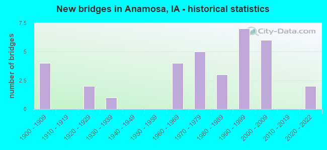
- New bridges - historical statistics
- 41900-1909
- 21920-1929
- 11930-1939
- 41960-1969
- 51970-1979
- 31980-1989
- 71990-1999
- 62000-2009
- 22020-2022
FCC Registered Antenna Towers: 76 (See the full list of FCC Registered Antenna Towers)
FCC Registered Broadcast Land Mobile Towers: 16 (See the full list of FCC Registered Broadcast Land Mobile Towers in Anamosa, IA)
FCC Registered Microwave Towers: 21 (See the full list of FCC Registered Microwave Towers in this town)
FCC Registered Amateur Radio Licenses: 58 (See the full list of FCC Registered Amateur Radio Licenses in Anamosa)
FAA Registered Aircraft: 10 (See the full list of FAA Registered Aircraft in Anamosa)
2002 - 2018 National Fire Incident Reporting System (NFIRS) incidents
- Fire incident types reported to NFIRS in Anamosa, IA
- 14542.0%Outside Fires
- 11934.5%Structure Fires
- 6719.4%Mobile Property/Vehicle Fires
- 144.1%Other
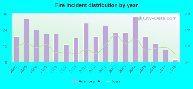 According to the data from the years 2002 - 2018 the average number of fires per year is 20. The highest number of reported fire incidents - 34 took place in 2014, and the least - 2 in 2018. The data has a declining trend.
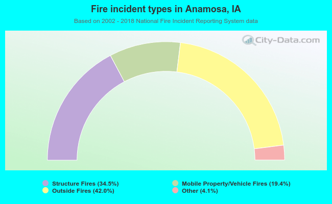 When looking into fire subcategories, the most incidents belonged to: Outside Fires (42.0%), and Structure Fires (34.5%).
Fire-safe hotels and motels in Anamosa, Iowa:
- Super 8, 100 Grant Wood Dr, Anamosa, Iowa 52205 , Phone: (319) 462-3888, Fax: (319) 462-3718
- Americinn Lodge & Suites Of Anamosa, Ia, 101 Harley Ave, Anamosa, Iowa 52205 , Phone: (319) 462-4119, Fax: (319) 462-4570
| Most common first names in Anamosa, IA among deceased individuals | ||
| Name | Count | Lived (average) |
|---|---|---|
| John | 58 | 75.9 years |
| William | 44 | 75.0 years |
| Robert | 39 | 74.5 years |
| Mary | 38 | 82.5 years |
| James | 31 | 72.6 years |
| Donald | 23 | 77.3 years |
| Charles | 22 | 75.6 years |
| George | 22 | 77.8 years |
| Anna | 21 | 83.5 years |
| Harold | 21 | 70.8 years |
| Most common last names in Anamosa, IA among deceased individuals | ||
| Last name | Count | Lived (average) |
|---|---|---|
| Smith | 22 | 80.1 years |
| Dirks | 20 | 73.8 years |
| Kula | 17 | 76.7 years |
| Thomas | 14 | 74.7 years |
| Harms | 13 | 76.3 years |
| Zimmerman | 13 | 78.3 years |
| Miller | 12 | 81.0 years |
| Thompson | 12 | 82.3 years |
| Taylor | 11 | 80.2 years |
| Johnson | 11 | 73.1 years |
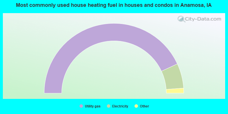
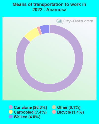
- 86.3%Utility gas
- 11.5%Electricity
- 1.7%Other fuel
- 0.4%Bottled, tank, or LP gas
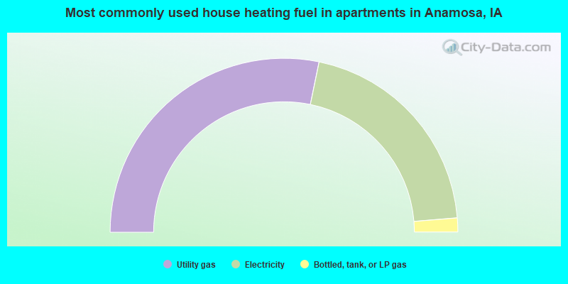
- 56.5%Utility gas
- 40.9%Electricity
- 2.6%Bottled, tank, or LP gas
Anamosa compared to Iowa state average:
- Unemployed percentage significantly below state average.
- Black race population percentage above state average.
- Hispanic race population percentage significantly below state average.
- Median age below state average.
- Foreign-born population percentage significantly below state average.
- Institutionalized population percentage significantly above state average.
Anamosa on our top lists:
- #34 on the list of "Top 101 cities with largest percentage of females in occupations: food preparation and serving related occupations (population 5,000+)"
- #94 on the list of "Top 101 cities with the largest percentage of people in state prisons (population 1,000+)"
State forum archive:

|
|
Total of 19 patent applications in 2008-2024.