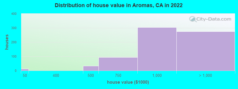
Estimated median house or condo value in 2022: over $1,000,000 (it was $300,300 in 2000)
Aromas:
over $1,000,000
CA:
$715,900
Mean prices in 2022:all housing units: $830,748; detached houses: $859,504; townhouses or other attached units: $670,998; in 2-unit structures: $407,181; in 3-to-4-unit structures: $687,481; in 5-or-more-unit structures: $411,852; mobile homes: $375,896; occupied boats, rvs, vans, etc.: $118,823
Median gross rent in 2022: $1,866.
March 2022 cost of living index in Aromas: 98.9 (near average, U.S. average is 100)
Latest news from Aromas, CA collected exclusively by city-data.com from local newspapers, TV, and radio stations
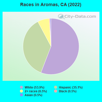
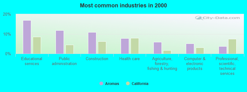
Ancestries: European (5.3%), English (4.8%), Russian (3.6%), Slovak (3.4%), German (3.1%), Swedish (2.8%).
Current Local Time: PST time zone
Elevation: 130 feet
Land area: 4.75 square miles.
Population density: 558 people per square mile (low).
317 residents are foreign born (11.0% Latin America).
This place:
11.1%
California:
26.5%
Median real estate property taxes paid for housing units with mortgages in 2022: $7,810 (0.7%) Median real estate property taxes paid for housing units with no mortgage in 2022: $5,824 (0.6%)
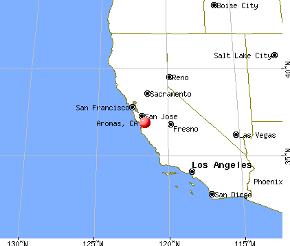
Nearest city with pop. 50,000+: Salinas, CA (14.1 miles , pop. 151,060).
Nearest city with pop. 200,000+: San Jose, CA (31.5 miles , pop. 894,943).
Nearest city with pop. 1,000,000+: Los Angeles, CA (267.1 miles , pop. 3,694,820).
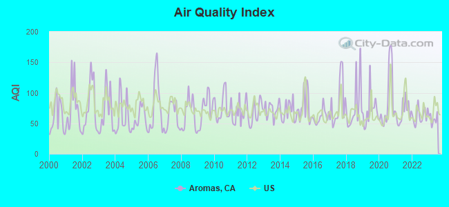
Air Quality Index (AQI) level in 2023 was 57.3. This is better than average.
City:
57.3
U.S.:
72.6
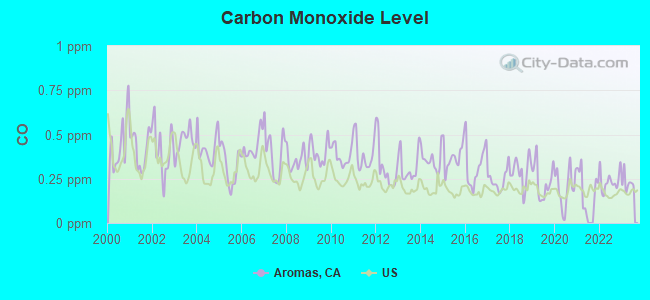
Carbon Monoxide (CO) [ppm] level in 2023 was 0.228. This is about average.Closest monitor was 8.6 miles away from the city center.
City:
0.228
U.S.:
0.251
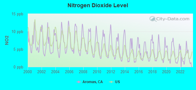
Nitrogen Dioxide (NO2) [ppb] level in 2023 was 2.40. This is significantly better than average.Closest monitor was 10.6 miles away from the city center.
City:
2.40
U.S.:
5.11
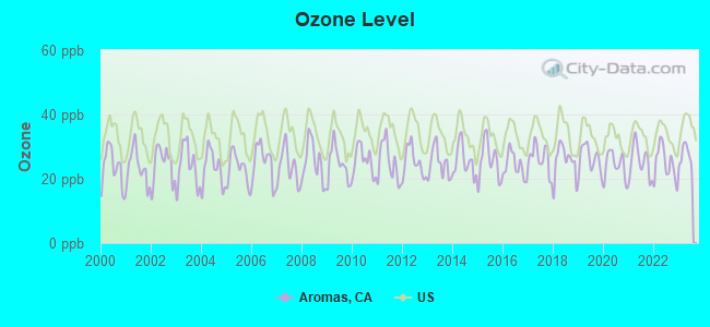
Ozone [ppb] level in 2023 was 27.2. This is better than average.Closest monitor was 8.6 miles away from the city center.
City:
27.2
U.S.:
33.3
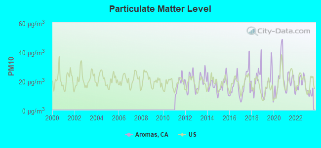
Particulate Matter (PM10) [µg/m3] level in 2023 was 12.0. This is significantly better than average.Closest monitor was 6.8 miles away from the city center.
City:
12.0
U.S.:
19.2
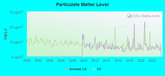
Particulate Matter (PM2.5) [µg/m3] level in 2023 was 5.25. This is significantly better than average.Closest monitor was 8.6 miles away from the city center.
City:
5.25
U.S.:
8.11
Earthquake activity:
Aromas-area historical earthquake activity is significantly above California state average. It is 7727% greater than the overall U.S. average.
On 4/18/1906 at 13:12:21, a magnitude 7.9 (7.9 UK, Class: Major, Intensity: VIII - XII) earthquake occurred 107.2 miles away from the city center, causing $524,000,000 total damage On 10/18/1989 at 00:04:15, a magnitude 7.1 (6.5 MB, 7.1 MS, 6.9 MW, 7.0 ML) earthquake occurred 17.0 miles away from the city center, causing 62 deaths (62 shaking deaths) and 3757 injuries, causing $1,305,032,704 total damage On 11/4/1927 at 13:51:53, a magnitude 7.5 (7.5 UK) earthquake occurred 140.6 miles away from Aromas center On 7/21/1952 at 11:52:14, a magnitude 7.7 (7.7 UK) earthquake occurred 197.2 miles away from the city center, causing $50,000,000 total damage On 5/2/1983 at 23:42:37, a magnitude 6.7 (6.2 MB, 6.5 MS, 6.5 MW, 6.7 ML, Class: Strong, Intensity: VII - IX) earthquake occurred 87.5 miles away from Aromas center, causing $31,000,000 total damage On 12/21/1932 at 06:10:09, a magnitude 7.2 (7.2 UK) earthquake occurred 224.7 miles away from the city center Magnitude types: body-wave magnitude (MB), local magnitude (ML), surface-wave magnitude (MS), moment magnitude (MW)
Natural disasters:
The number of natural disasters in San Benito County (13) is near the US average (15). Major Disasters (Presidential) Declared: 8 Emergencies Declared: 2
Causes of natural disasters: Floods: 8, Storms: 4, Winter Storms: 4, Mudslides: 2, Drought: 1, Earthquake: 1, Freeze: 1, Hurricane: 1, Landslide: 1, Tornado: 1, Other: 1 (Note: some incidents may be assigned to more than one category).
Hospitals and medical centers near Aromas:
VALLEY CONVALESCENT HOSPITAL (Nursing Home, about 7 miles away; WATSONVILLE, CA)
COUNTRY VILLA WATSONVILLE WEST NRSG AND REHAB CENTER (Nursing Home, about 8 miles away; WATSONVILLE, CA)
WATSONVILLE COMMUNITY HOSPITAL D/P SNF (Nursing Home, about 9 miles away; WATSONVILLE, CA)
SATELLITE DIALYSIS (Dialysis Facility, about 9 miles away; WATSONVILLE, CA)
WREN HOUSE (Hospital, about 9 miles away; GILROY, CA)
SAN MIGUEL HOUSE (Hospital, about 9 miles away; GILROY, CA)
GILROY HEALTHCARE AND REHABILITATION CENTER (Nursing Home, about 10 miles away; GILROY, CA)
Amtrak stations near Aromas:
7 miles: WATSONVILLE (W. LAKE AVE. & RODRIGUEZ ST.) - Bus Station . Services: fully wheelchair accessible, public payphones, snack bar, free short-term parking, taxi stand, public transit connection.
10 miles: GILROY (7250 MONTEREY HWY.) - Bus Station . Services: partially wheelchair accessible, public payphones, free short-term parking, free long-term parking, public transit connection.
15 miles: SALINAS (11 STATION PLACE) . Services: ticket office, partially wheelchair accessible, enclosed waiting area, public restrooms, public payphones, vending machines, free short-term parking, free long-term parking, call for car rental service, call for taxi service, public transit connection.
Colleges/universities with over 2000 students nearest to Aromas:
Gavilan College (about 8 miles; Gilroy, CA; Full-time enrollment: 3,327)
Hartnell College (about 15 miles; Salinas, CA; FT enrollment: 5,506)
Cabrillo College (about 18 miles; Aptos, CA; FT enrollment: 7,729)
California State University-Monterey Bay (about 19 miles; Seaside, CA; FT enrollment: 5,125)
Naval Postgraduate School (about 24 miles; Monterey, CA; FT enrollment: 4,951)
Monterey Peninsula College (about 25 miles; Monterey, CA; FT enrollment: 4,588)
University of California-Santa Cruz (about 25 miles; Santa Cruz, CA; FT enrollment: 17,751)
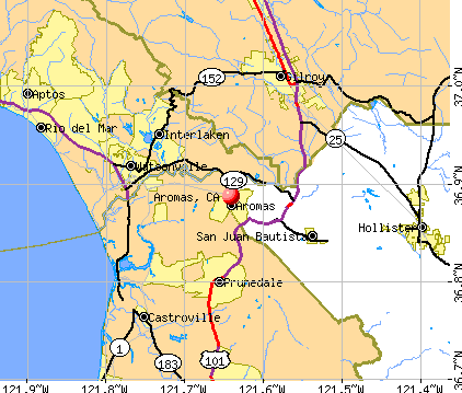
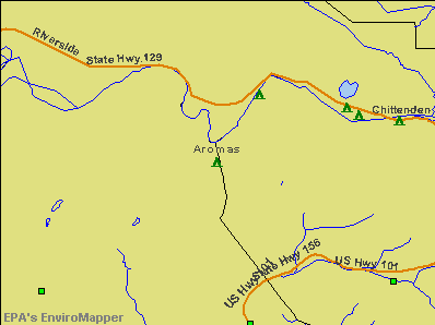
Notable locations in Aromas: Aromas Branch Monterey County Free Libraries (A), Department of Forestry and Fire Protection Aromas Tri - County Fire District (B). Display/hide their locations on the map
San Benito County has a predicted average indoor radon screening level between 2 and 4 pCi/L (pico curies per liter) - Moderate Potential
Drinking water stations with addresses in Aromas and their reported violations in the past:
AROMAS WATER DISTRICT (Address: 387 BLOHM AVENUE , Population served: 2,700, Groundwater):
Past monitoring violations:
One routine major monitoring violation
AROMAS HILLS MUTUAL WATER ASSOCIATION (Population served: 44, Groundwater):
Past monitoring violations:
Monitoring and Reporting (DBP) - Between JAN-2005 and DEC-2005, Contaminant: Total Haloacetic Acids (HAA5). Follow-up actions: St Compliance achieved (OCT-10-2006)
Monitoring and Reporting (DBP) - Between JAN-2005 and DEC-2005, Contaminant: TTHM. Follow-up actions: St Compliance achieved (OCT-10-2006)
Initial Tap Sampling for Pb and Cu - In JUL-01-1993, Contaminant: Lead and Copper Rule. Follow-up actions: Fed Compliance achieved (JUL-31-2006)
One routine major monitoring violation
One regular monitoring violation
EL CAMINO REAL WS #16 (Population served: 29, Groundwater):
Past monitoring violations:
Monitoring, Repeat Major (TCR) - In FEB-2005, Contaminant: Coliform (TCR). Follow-up actions: St Violation/Reminder Notice (MAR-16-2005)
Monitoring, Repeat Major (TCR) - In FEB-2005, Contaminant: Coliform (TCR). Follow-up actions: St Violation/Reminder Notice (MAR-16-2005)
6 routine major monitoring violations
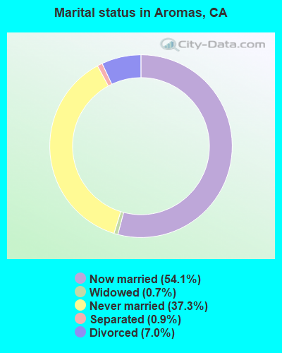
Average household size:
This place:
3.0 people
California:
2.9 people
Percentage of family households:
This place:
78.7%
Whole state:
68.7%
Percentage of households with unmarried partners:
This place:
5.3%
Whole state:
7.2%
Likely homosexual households (counted as self-reported same-sex unmarried-partner households)
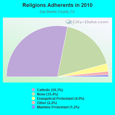
Religion statistics for Aromas, CA (based on San Benito County data)
Religion
Adherents
Congregations
Catholic
31,105
3
Evangelical Protestant
2,694
21
Other
1,204
5
Mainline Protestant
687
3
None
19,579
-
Source: Clifford Grammich, Kirk Hadaway, Richard Houseal, Dale E.Jones, Alexei Krindatch, Richie Stanley and Richard H.Taylor. 2012. 2010 U.S.Religion Census: Religious Congregations & Membership Study. Association of Statisticians of American Religious Bodies. Jones, Dale E., et al. 2002. Congregations and Membership in the United States 2000. Nashville, TN: Glenmary Research Center. Graphs represent county-level data
Mehran Nazari, West Of Us 101 0.29 Miles Se Of Jct G11 And Dumbarton Rd. (Lat: 36.850583 Lon: -121.636500), Type: 10.7, Structure height: 06053 m, Overall height: 10.7 m, Registrant: Alpine Pcs Operating, LLC, Mnazari@adgentelecom.Com, , Great- Falls, Phone: (703) 757-6757
Aircraft: BEECH B36TC (Category: Land, Seats: 6, Weight: Up to 12,499 Pounds), Engine: CONT MOTOR TSIO-520 SER (300 HP) (Reciprocating) N-Number: 1557D, N1557D, N-1557D, Serial Number: EA-494, Year manufactured: 1989, Airworthiness Date: 06/30/1989, Certificate Issue Date: 04/21/2016 Registrant (LLC): B36tc LLC, 19115 El Cerrito Way, Aromas, CA 95004
Aircraft: MONTEROSSO RICHARD S SH-2-TD (Category: Land, Seats: 2, Weight: Up to 12,499 Pounds), Engine: LYCOMING 0-320 SERIES (180 HP) (Reciprocating) N-Number: 191DK, N191DK, N-191DK, Serial Number: S/H 191, Airworthiness Date: 08/20/1987, Certificate Issue Date: 04/21/2017 Registrant (Individual): Ted F Grachek, 880 Cole Rd, Aromas, CA 95004 Deregistered:Cancel Date: 07/02/2013
Aircraft: CESSNA 152 (Category: Land, Seats: 2, Weight: Up to 12,499 Pounds), Engine: LYCOMING 0-235 SERIES (115 HP) (4 Cycle) N-Number: 24288, N24288, N-24288, Serial Number: 15280196, Airworthiness Date: 08/18/1977, Certificate Issue Date: 01/02/2018 Registrant (Individual): Philip J Cowley, Po Box 1139, Aromas, CA 95004 Deregistered:Cancel Date: 09/19/2014
Aircraft: STINSON 108-3 (Category: Land, Seats: 4, Weight: Up to 12,499 Pounds, Speed: 94 mph), Engine: FRANKLIN 6A-350SER (235 HP) (Reciprocating) N-Number: 527C, N527C, N-527C, Serial Number: 108-3527, Year manufactured: 1948, Airworthiness Date: 09/03/1987, Certificate Issue Date: 12/09/1982 Registrant (Co-Owned): Richard F Fischer, 797 Seely Ave, Aromas, CA 95004, Other Owners: Pamela J Fischer
Aircraft: GRACHEK TED F RAF 2000 (Category: Land, Seats: 2, Weight: Up to 12,499 Pounds), Engine: Reciprocating N-Number: 881T, N881T, N-881T, Serial Number: H2-04-15-630, Certificate Issue Date: 02/05/2008 Registrant (Individual): Ted F Grachek, 880 Cole Rd, Aromas, CA 95004
Aircraft: MCFADDEN EDWARD L RV-4 (Category: Land, Seats: 2, Weight: Up to 12,499 Pounds), Engine: LYCOMING 0-320 SERIES (180 HP) (Reciprocating) N-Number: 91EM, N91EM, N-91EM, Serial Number: 1773, Airworthiness Date: 05/29/1991, Certificate Issue Date: 08/31/2015 Registrant (Individual): Matthew Frazeur, Po Box 506, Aromas, CA 95004
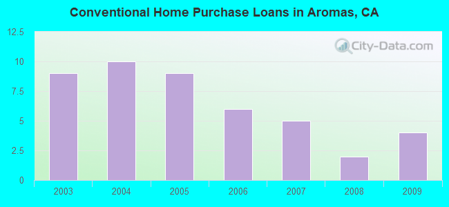
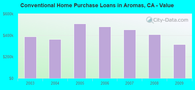
Home Mortgage Disclosure Act Aggregated Statistics For Year 2009 (Based on 1 partial tract)
A) FHA, FSA/RHS & VA Home Purchase Loans
B) Conventional Home Purchase Loans
C) Refinancings
F) Non-occupant Loans on < 5 Family Dwellings (A B C & D)
Number
Average Value
Number
Average Value
Number
Average Value
Number
Average Value
LOANS ORIGINATED
1
$306,060
4
$316,490
10
$295,060
1
$213,430
APPLICATIONS APPROVED, NOT ACCEPTED
0
$0
1
$173,280
2
$291,290
0
$0
APPLICATIONS DENIED
0
$0
1
$157,810
5
$307,870
0
$0
APPLICATIONS WITHDRAWN
0
$0
0
$0
2
$381,580
0
$0
FILES CLOSED FOR INCOMPLETENESS
0
$0
0
$0
1
$396,610
0
$0
Aggregated Statistics For Year 2008 (Based on 1 partial tract)
B) Conventional Home Purchase Loans
C) Refinancings
D) Home Improvement Loans
F) Non-occupant Loans on < 5 Family Dwellings (A B C & D)
Number
Average Value
Number
Average Value
Number
Average Value
Number
Average Value
LOANS ORIGINATED
2
$407,125
7
$325,006
1
$247,320
1
$212,730
APPLICATIONS APPROVED, NOT ACCEPTED
0
$0
2
$404,520
0
$0
0
$0
APPLICATIONS DENIED
0
$0
6
$433,255
0
$0
0
$0
APPLICATIONS WITHDRAWN
1
$324,660
2
$478,125
0
$0
0
$0
FILES CLOSED FOR INCOMPLETENESS
0
$0
1
$328,310
0
$0
0
$0
Aggregated Statistics For Year 2007 (Based on 1 partial tract)
B) Conventional Home Purchase Loans
C) Refinancings
D) Home Improvement Loans
G) Loans On Manufactured Home Dwelling (A B C & D)
Number
Average Value
Number
Average Value
Number
Average Value
Number
Average Value
LOANS ORIGINATED
5
$451,358
13
$424,366
1
$373,150
1
$252,710
APPLICATIONS APPROVED, NOT ACCEPTED
2
$260,700
3
$331,147
0
$0
1
$229,760
APPLICATIONS DENIED
4
$348,512
9
$459,778
2
$287,465
1
$226,810
APPLICATIONS WITHDRAWN
1
$170,320
2
$405,300
0
$0
0
$0
FILES CLOSED FOR INCOMPLETENESS
1
$112,970
1
$184,050
0
$0
0
$0
Aggregated Statistics For Year 2006 (Based on 1 partial tract)
B) Conventional Home Purchase Loans
C) Refinancings
D) Home Improvement Loans
F) Non-occupant Loans on < 5 Family Dwellings (A B C & D)
G) Loans On Manufactured Home Dwelling (A B C & D)
Number
Average Value
Number
Average Value
Number
Average Value
Number
Average Value
Number
Average Value
LOANS ORIGINATED
6
$481,165
18
$458,079
3
$276,807
1
$267,650
0
$0
APPLICATIONS APPROVED, NOT ACCEPTED
2
$604,390
3
$549,440
0
$0
0
$0
0
$0
APPLICATIONS DENIED
5
$584,142
8
$466,175
1
$156,420
0
$0
1
$134,350
APPLICATIONS WITHDRAWN
1
$618,550
5
$417,746
0
$0
0
$0
0
$0
FILES CLOSED FOR INCOMPLETENESS
1
$306,410
1
$345,170
0
$0
0
$0
0
$0
Aggregated Statistics For Year 2005 (Based on 1 partial tract)
B) Conventional Home Purchase Loans
C) Refinancings
D) Home Improvement Loans
F) Non-occupant Loans on < 5 Family Dwellings (A B C & D)
G) Loans On Manufactured Home Dwelling (A B C & D)
Number
Average Value
Number
Average Value
Number
Average Value
Number
Average Value
Number
Average Value
LOANS ORIGINATED
9
$506,704
20
$373,922
2
$412,950
2
$335,000
0
$0
APPLICATIONS APPROVED, NOT ACCEPTED
3
$424,073
2
$419,990
0
$0
0
$0
1
$218,120
APPLICATIONS DENIED
4
$514,535
10
$433,144
1
$262,610
1
$230,810
1
$301,720
APPLICATIONS WITHDRAWN
2
$344,035
6
$493,302
1
$328,310
0
$0
0
$0
FILES CLOSED FOR INCOMPLETENESS
0
$0
2
$349,250
0
$0
0
$0
0
$0
Aggregated Statistics For Year 2004 (Based on 1 partial tract)
B) Conventional Home Purchase Loans
C) Refinancings
D) Home Improvement Loans
F) Non-occupant Loans on < 5 Family Dwellings (A B C & D)
G) Loans On Manufactured Home Dwelling (A B C & D)
Number
Average Value
Number
Average Value
Number
Average Value
Number
Average Value
Number
Average Value
LOANS ORIGINATED
10
$361,869
21
$344,538
2
$231,500
1
$172,410
1
$302,930
APPLICATIONS APPROVED, NOT ACCEPTED
2
$340,995
5
$252,462
0
$0
0
$0
1
$141,300
APPLICATIONS DENIED
2
$430,935
7
$364,657
1
$184,400
0
$0
0
$0
APPLICATIONS WITHDRAWN
2
$368,630
7
$337,073
0
$0
0
$0
0
$0
FILES CLOSED FOR INCOMPLETENESS
0
$0
2
$374,625
0
$0
0
$0
0
$0
Aggregated Statistics For Year 2003 (Based on 1 partial tract)
B) Conventional Home Purchase Loans
C) Refinancings
D) Home Improvement Loans
F) Non-occupant Loans on < 5 Family Dwellings (A B C & D)
Detailed HMDA statistics for the following Tracts:0101.02
Private Mortgage Insurance Companies Aggregated Statistics For Year 2009 (Based on 1 partial tract)
A) Conventional Home Purchase Loans
Number
Average Value
LOANS ORIGINATED
0
$0
APPLICATIONS APPROVED, NOT ACCEPTED
1
$179,540
APPLICATIONS DENIED
0
$0
APPLICATIONS WITHDRAWN
1
$212,730
FILES CLOSED FOR INCOMPLETENESS
0
$0
Detailed PMIC statistics for the following Tracts:0101.02
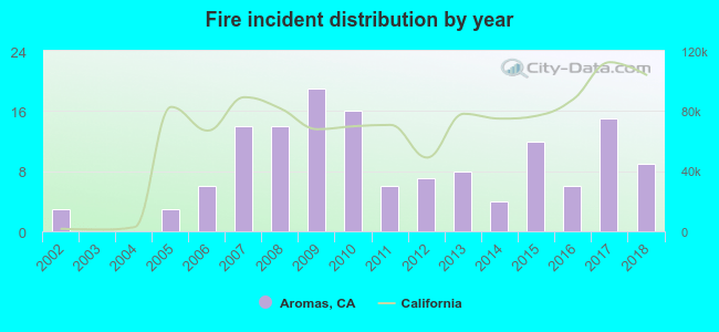
2002 - 2018 National Fire Incident Reporting System (NFIRS) incidents
Based on the data from the years 2002 - 2018 the average number of fires per year is 8. The highest number of fires - 19 took place in 2009, and the least - 0 in 2003. The data has an increasing trend.
When looking into fire subcategories, the most incidents belonged to: Outside Fires (38.0%), and Structure Fires (34.5%).
Fire incident types reported to NFIRS in Aromas, CA


 Recent articles from our blog. Our writers, many of them Ph.D. graduates or candidates, create easy-to-read articles on a wide variety of topics.

 (14.1 miles
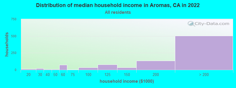


 Based on the data from the years 2002 - 2018 the average number of fires per year is 8. The highest number of fires - 19 took place in 2009, and the least - 0 in 2003. The data has an increasing trend.
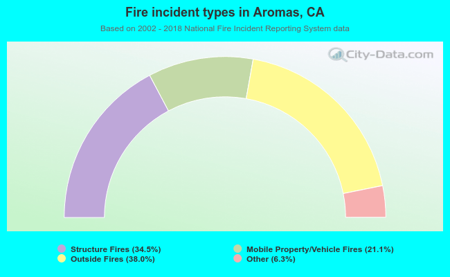 When looking into fire subcategories, the most incidents belonged to: Outside Fires (38.0%), and Structure Fires (34.5%).