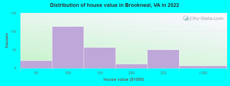
Estimated median house or condo value in 2022: $111,497 (it was $51,900 in 2000)
Brookneal:
$111,497
VA:
$365,700
Mean prices in 2022:all housing units: $252,774; detached houses: $273,539; townhouses or other attached units: $288,775; in 2-unit structures: $192,000; in 5-or-more-unit structures: $241,259; mobile homes: $105,799
Median gross rent in 2022: $890.
March 2022 cost of living index in Brookneal: 83.5 (less than average, U.S. average is 100)
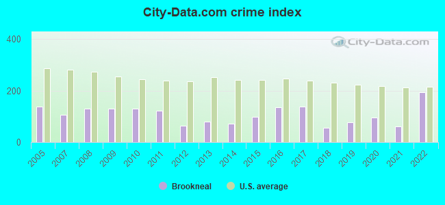
The City-Data.com crime index weighs serious crimes and violent crimes more heavily. Higher means more crime, U.S. average is 246.1. It adjusts for the number of visitors and daily workers commuting into cities.
Latest news from Brookneal, VA collected exclusively by city-data.com from local newspapers, TV, and radio stations
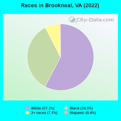
Ancestries: American (43.0%), African (11.8%), Irish (2.1%).
Current Local Time: EST time zone
Incorporated in 1908
Elevation: 560 feet
Land area: 3.50 square miles.
Population density: 308 people per square mile (very low).
5 residents are foreign born
This town:
0.4%
Virginia:
12.6%
Median real estate property taxes paid for housing units with mortgages in 2022: $648 (0.4%) Median real estate property taxes paid for housing units with no mortgage in 2022: $432 (0.5%)
Nearest city with pop. 50,000+: Lynchburg, VA (27.3 miles , pop. 65,269).
Nearest city with pop. 200,000+: Greensboro, NC (83.0 miles , pop. 223,891).
Nearest city with pop. 1,000,000+: Philadelphia, PA (289.4 miles , pop. 1,517,550).
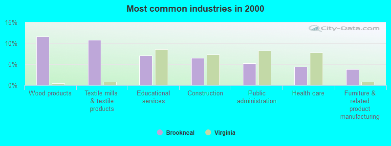
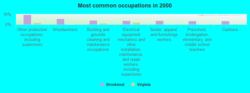
Other production occupations, including supervisors (9.6%)
Woodworkers (5.7%)
Building and grounds cleaning and maintenance occupations (4.3%)
Electrical equipment mechanics and other installation, maintenance, and repair workers, including supervisors (4.1%)
Textile, apparel, and furnishings workers (4.1%)
Preschool, kindergarten, elementary, and middle school teachers (3.7%)
Cashiers (3.7%)
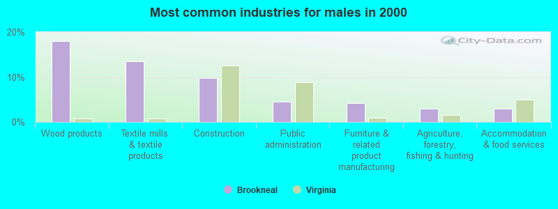
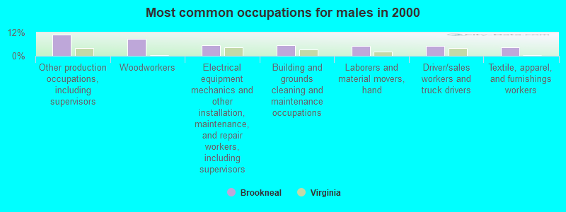
Other production occupations, including supervisors (10.9%)
Woodworkers (8.6%)
Electrical equipment mechanics and other installation, maintenance, and repair workers, including supervisors (5.6%)
Building and grounds cleaning and maintenance occupations (5.6%)
Laborers and material movers, hand (5.2%)
Driver/sales workers and truck drivers (5.2%)
Textile, apparel, and furnishings workers (4.5%)
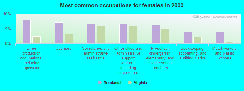
Other production occupations, including supervisors (8.0%)
Cashiers (7.1%)
Secretaries and administrative assistants (6.7%)
Other office and administrative support workers, including supervisors (6.7%)
Preschool, kindergarten, elementary, and middle school teachers (6.2%)
Bookkeeping, accounting, and auditing clerks (4.0%)
Metal workers and plastic workers (4.0%)
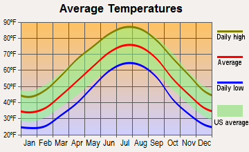
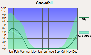
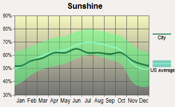
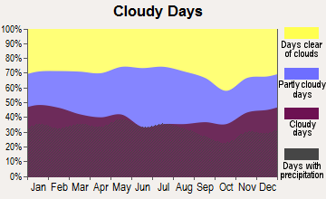
Average climate in Brookneal, Virginia
Based on data reported by over 4,000 weather stations
Tornado activity:
Brookneal-area historical tornado activity is slightly below Virginia state average. It is 48% smaller than the overall U.S. average.
On 3/24/1969, a category F3 (max. wind speeds 158-206 mph) tornado 30.3 miles away from the Brookneal town center killed one personand injured 4 peopleand causedbetween $5000 and $50,000 in damages.
On 6/16/1966, a category F3 tornado 33.8 miles away from the town center causedbetween $500 and $5000 in damages.
Earthquake activity:
Brookneal-area historical earthquake activity is significantly above Virginia state average. It is 42% smaller than the overall U.S. average.
On 8/23/2011 at 17:51:04, a magnitude 5.8 (5.8 MW, Depth: 3.7 mi, Class: Moderate, Intensity: VI - VII) earthquake occurred 81.1 miles away from the city center On 8/9/2020 at 12:07:37, a magnitude 5.1 (5.1 MW, Depth: 4.7 mi) earthquake occurred 125.5 miles away from the city center On 12/9/2003 at 20:59:18, a magnitude 4.5 (4.5 ML, Depth: 6.2 mi, Class: Light, Intensity: IV - V) earthquake occurred 68.2 miles away from the city center On 12/9/2003 at 20:59:14, a magnitude 4.5 (4.5 MB, 4.5 LG) earthquake occurred 68.2 miles away from the city center On 8/25/2011 at 05:07:52, a magnitude 4.5 (4.5 ML, Depth: 4.2 mi) earthquake occurred 81.9 miles away from Brookneal center On 8/24/2011 at 00:04:36, a magnitude 4.2 (4.2 ML) earthquake occurred 80.7 miles away from Brookneal center Magnitude types: regional Lg-wave magnitude (LG), body-wave magnitude (MB), local magnitude (ML), moment magnitude (MW)
Natural disasters:
The number of natural disasters in Campbell County (19) is greater than the US average (15). Major Disasters (Presidential) Declared: 13 Emergencies Declared: 5
Causes of natural disasters: Storms: 7, Floods: 4, Hurricanes: 4, Winter Storms: 3, Droughts: 2, Ice Storms: 2, Tropical Storms: 2, Blizzard: 1, Tornado: 1, Wind: 1, Other: 1 (Note: some incidents may be assigned to more than one category).
Tourist attraction: Red Hill-Patrick Henry National Memorial (1250 Red Hill Road).
Hotel: Brookneal Motel (Highway 501).
Birthplace of: Edward P. Hurt - Football player and coach, Charlie Pick - Baseball player, Lewis A. Pick - Army general.
Campbell County has a predicted average indoor radon screening level greater than 4 pCi/L (pico curies per liter) - Highest Potential
Drinking water stations with addresses in Brookneal and their reported violations in the past:
BROOKNEAL, TOWN OF (Population served: 1,500, Surface water):
Past health violations:
MCL, Average - Between APR-2014 and JUN-2014, Contaminant: TTHM. Follow-up actions: St Formal NOV issued (JUN-24-2014), St Public Notif requested (JUN-24-2014)
MCL, Average - Between JAN-2014 and MAR-2014, Contaminant: TTHM. Follow-up actions: St Public Notif requested (MAY-02-2014), St Formal NOV issued (MAY-02-2014), St Public Notif received (JUN-04-2014)
MCL, Average - Between OCT-2013 and DEC-2013, Contaminant: TTHM. Follow-up actions: St Public Notif requested (JAN-29-2014), St Formal NOV issued (JAN-29-2014), St Public Notif received (MAR-03-2014)
MCL, Average - Between JAN-2013 and MAR-2013, Contaminant: TTHM. Follow-up actions: St Public Notif requested (MAY-01-2013), St Formal NOV issued (MAY-01-2013), St Compliance achieved (MAY-28-2013), St Public Notif received (JUN-10-2013)
MCL, Average - Between OCT-2012 and DEC-2012, Contaminant: TTHM. Follow-up actions: St Public Notif requested (NOV-30-2012), St Formal NOV issued (NOV-30-2012), St Public Notif received (DEC-28-2012), St Compliance achieved (MAY-28-2013)
MCL, Average - Between JUL-2012 and SEP-2012, Contaminant: TTHM. Follow-up actions: St Public Notif requested (SEP-10-2012), St Formal NOV issued (SEP-10-2012), St Public Notif received (OCT-09-2012), St Compliance achieved (MAY-28-2013)
11 other older health violations
Past monitoring violations:
Treatment Technique No Certif. Operator - In AUG-01-2007, Contaminant: DBP Stage 1. Follow-up actions: St Formal NOV issued (AUG-02-2007), St Public Notif requested (AUG-02-2007), St Compliance achieved (AUG-02-2007), St Public Notif received (AUG-20-2007)
2 minor monitoring violations
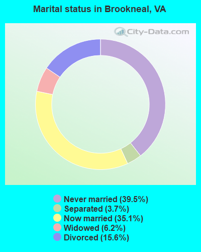
Average household size:
This town:
2.3 people
Virginia:
2.5 people
Percentage of family households:
This town:
62.6%
Whole state:
67.0%
Percentage of households with unmarried partners:
This town:
7.1%
Whole state:
5.7%
Likely homosexual households (counted as self-reported same-sex unmarried-partner households)
Lesbian couples: 0.0% of all households
Gay men: 0.9% of all households
42 people in nursing facilities/skilled-nursing facilities in 2010
60 people in nursing homes in 2000
Banks with branches in Brookneal (2011 data):
The Bank of Charlotte County: Brookneal Branch at Water Street And Lynchburg Avenue, branch established on 1988/11/01. Info updated 2006/11/03: Bank assets: $121.0 mil, Deposits: $99.5 mil, headquarters in Phenix, VA, positive income, 4 total offices, Holding Company: Bcc Bankshares, Inc.
Branch Banking and Trust Company: Brookneal Branch at 440 Lusardi Drive, branch established on 1981/01/02. Info updated 2010/03/29: Bank assets: $168,867.6 mil, Deposits: $127,549.5 mil, headquarters in Winston Salem, NC, positive income, Commercial Lending Specialization, 1793 total offices, Holding Company: Bb&T Corporation
Wells Fargo Bank, National Association: Brookneal Branch at 227 Main Street, branch established on 1937/09/28. Info updated 2011/04/05: Bank assets: $1,161,490.0 mil, Deposits: $905,653.0 mil, headquarters in Sioux Falls, SD, positive income, 6395 total offices, Holding Company: Wells Fargo & Company
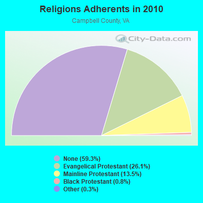
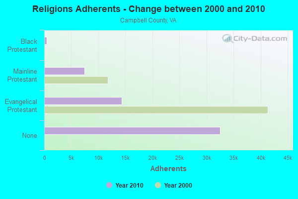
Religion statistics for Brookneal, VA (based on Campbell County data)
Religion
Adherents
Congregations
Evangelical Protestant
14,339
58
Mainline Protestant
7,412
32
Black Protestant
430
4
Other
153
4
None
32,508
-
Source: Clifford Grammich, Kirk Hadaway, Richard Houseal, Dale E.Jones, Alexei Krindatch, Richie Stanley and Richard H.Taylor. 2012. 2010 U.S.Religion Census: Religious Congregations & Membership Study. Association of Statisticians of American Religious Bodies. Jones, Dale E., et al. 2002. Congregations and Membership in the United States 2000. Nashville, TN: Glenmary Research Center. Graphs represent county-level data
Aircraft: OFFIELD RONNIE KOLB FIRESTAR (Category: Land, Weight: Up to 12,499 Pounds), Engine: ROTAX 503 SERIES (52 HP) (2 Cycle) N-Number: 136RB, N136RB, N-136RB, Serial Number: FS-00-1-00020, Year manufactured: 1999, Airworthiness Date: 12/13/2007, Certificate Issue Date: 10/03/2014 Registrant (Individual): David C Roach, 303 Partridge Ln, Brookneal, VA 24528
Aircraft: CESSNA 140 (Category: Land, Seats: 2, Weight: Up to 12,499 Pounds, Speed: 105 mph), Engine: CONT MOTOR C90 SERIES (95 HP) (Reciprocating) N-Number: 3659V, N3659V, N-3659V, Serial Number: 14930, Year manufactured: 1948, Airworthiness Date: 06/08/1956, Certificate Issue Date: 05/27/1999 Registrant (Individual): Charles D Cole, 759 Tip Ln, Brookneal, VA 24528
Aircraft: CESSNA 560 (Category: Land, Engines: 2, Seats: 11, Weight: 12,500 - 19,999 Pounds), Engine: P&W CANADA JT15D 5 SER (2900 Pounds of Thrust) (Turbo-fan) N-Number: 629FF, N629FF, N-629FF, Serial Number: 560-0490, Year manufactured: 1998, Airworthiness Date: 09/30/1998, Certificate Issue Date: 01/23/2018 Registrant (LLC): Wrf Flight LLC, Po Box 190, Brookneal, VA 24528
Aircraft: CESSNA 150M (Category: Land, Seats: 2, Weight: Up to 12,499 Pounds, Speed: 81 mph), Engine: CONT MOTOR 0-200 SERIES (100 HP) (4 Cycle) N-Number: 704WB, N704WB, N-704WB, Serial Number: 15078922, Year manufactured: 1976, Airworthiness Date: 11/24/1976, Certificate Issue Date: 07/01/2020 Registrant (Individual): Jacob M Clee, 7141 Hat Creek Rd, Brookneal, VA 24528
Aircraft: NASH LARRY W BUCKEYE DREAM MACHIN (Category: Land, Seats: 2, Weight: Up to 12,499 Pounds), Engine: ROTAX 582DCDI (65 HP) (2 Cycle) N-Number: 7191K, N7191K, N-7191K, Serial Number: 4013, Year manufactured: 1997, Airworthiness Date: 09/28/2007, Certificate Issue Date: 06/29/2007 Registrant (Individual): Larry W Nash, 985 Juniper Cliff Rd, Brookneal, VA 24528
Aircraft: BEECH C18S (Category: Land, Engines: 2, Seats: 10, Weight: Up to 12,499 Pounds, Speed: 165 mph), Engine: P&W R-985 SERIES (450 HP) (Reciprocating) N-Number: 8040H, N8040H, N-8040H, Serial Number: AF-8455, Year manufactured: 1957, Certificate Issue Date: 04/11/1972 Registrant (Individual): Glen Holt, Route 1, Brookneal, VA 24528 Deregistered:Cancel Date: 03/16/2018
Aircraft: CALLAIR A-9 (Category: Land, Seats: 2, Weight: Up to 12,499 Pounds, Speed: 93 mph), Engine: LYCOMING 0-540 SERIES (250 HP) (Reciprocating) N-Number: 8269H, N8269H, N-8269H, Serial Number: 1142, Year manufactured: 1965, Certificate Issue Date: 07/10/1969 Registrant (Individual): Glen Holt, Route 1, Brookneal, VA 24528 Deregistered:Cancel Date: 02/04/2017
Home Mortgage Disclosure Act Aggregated Statistics For Year 2009 (Based on 1 partial tract)
C) Refinancings
Number
Average Value
LOANS ORIGINATED
1
$154,950
APPLICATIONS APPROVED, NOT ACCEPTED
0
$0
APPLICATIONS DENIED
1
$118,990
APPLICATIONS WITHDRAWN
0
$0
FILES CLOSED FOR INCOMPLETENESS
0
$0
Aggregated Statistics For Year 2008 (Based on 1 partial tract)
B) Conventional Home Purchase Loans
C) Refinancings
Number
Average Value
Number
Average Value
LOANS ORIGINATED
1
$63,860
1
$126,040
APPLICATIONS APPROVED, NOT ACCEPTED
0
$0
0
$0
APPLICATIONS DENIED
0
$0
1
$167,740
APPLICATIONS WITHDRAWN
0
$0
1
$57,670
FILES CLOSED FOR INCOMPLETENESS
0
$0
0
$0
Aggregated Statistics For Year 2007 (Based on 1 partial tract)
B) Conventional Home Purchase Loans
C) Refinancings
D) Home Improvement Loans
G) Loans On Manufactured Home Dwelling (A B C & D)
Number
Average Value
Number
Average Value
Number
Average Value
Number
Average Value
LOANS ORIGINATED
1
$110,400
2
$109,835
1
$27,110
1
$33,260
APPLICATIONS APPROVED, NOT ACCEPTED
0
$0
1
$51,490
0
$0
0
$0
APPLICATIONS DENIED
0
$0
2
$60,565
0
$0
0
$0
APPLICATIONS WITHDRAWN
0
$0
1
$97,500
0
$0
0
$0
FILES CLOSED FOR INCOMPLETENESS
0
$0
0
$0
0
$0
0
$0
Aggregated Statistics For Year 2006 (Based on 1 partial tract)
B) Conventional Home Purchase Loans
C) Refinancings
G) Loans On Manufactured Home Dwelling (A B C & D)
Number
Average Value
Number
Average Value
Number
Average Value
LOANS ORIGINATED
1
$98,470
2
$79,835
0
$0
APPLICATIONS APPROVED, NOT ACCEPTED
0
$0
0
$0
0
$0
APPLICATIONS DENIED
0
$0
2
$61,895
1
$31,760
APPLICATIONS WITHDRAWN
0
$0
1
$110,960
0
$0
FILES CLOSED FOR INCOMPLETENESS
0
$0
0
$0
0
$0
Aggregated Statistics For Year 2005 (Based on 1 partial tract)
B) Conventional Home Purchase Loans
C) Refinancings
D) Home Improvement Loans
G) Loans On Manufactured Home Dwelling (A B C & D)
Number
Average Value
Number
Average Value
Number
Average Value
Number
Average Value
LOANS ORIGINATED
1
$76,990
2
$100,295
1
$27,680
0
$0
APPLICATIONS APPROVED, NOT ACCEPTED
0
$0
1
$50,920
0
$0
0
$0
APPLICATIONS DENIED
1
$59,210
2
$79,030
1
$9,300
1
$40,240
APPLICATIONS WITHDRAWN
0
$0
1
$65,470
0
$0
0
$0
FILES CLOSED FOR INCOMPLETENESS
0
$0
0
$0
0
$0
0
$0
Aggregated Statistics For Year 2004 (Based on 1 partial tract)
B) Conventional Home Purchase Loans
C) Refinancings
D) Home Improvement Loans
F) Non-occupant Loans on < 5 Family Dwellings (A B C & D)
G) Loans On Manufactured Home Dwelling (A B C & D)
Number
Average Value
Number
Average Value
Number
Average Value
Number
Average Value
Number
Average Value
LOANS ORIGINATED
1
$89,290
3
$68,063
1
$12,980
1
$33,900
1
$31,350
APPLICATIONS APPROVED, NOT ACCEPTED
0
$0
1
$34,840
0
$0
0
$0
0
$0
APPLICATIONS DENIED
1
$34,460
3
$78,377
0
$0
0
$0
1
$36,640
APPLICATIONS WITHDRAWN
0
$0
1
$127,610
0
$0
0
$0
0
$0
FILES CLOSED FOR INCOMPLETENESS
0
$0
0
$0
0
$0
0
$0
0
$0
Aggregated Statistics For Year 2003 (Based on 1 partial tract)
B) Conventional Home Purchase Loans
C) Refinancings
D) Home Improvement Loans
Number
Average Value
Number
Average Value
Number
Average Value
LOANS ORIGINATED
1
$59,400
3
$94,137
1
$15,900
APPLICATIONS APPROVED, NOT ACCEPTED
0
$0
1
$40,270
0
$0
APPLICATIONS DENIED
0
$0
2
$84,975
0
$0
APPLICATIONS WITHDRAWN
0
$0
1
$84,940
0
$0
FILES CLOSED FOR INCOMPLETENESS
0
$0
0
$0
0
$0
Aggregated Statistics For Year 2002 (Based on 1 partial tract)
B) Conventional Home Purchase Loans
C) Refinancings
D) Home Improvement Loans
F) Non-occupant Loans on < 5 Family Dwellings (A B C & D)
Number
Average Value
Number
Average Value
Number
Average Value
Number
Average Value
LOANS ORIGINATED
1
$77,140
3
$76,913
0
$0
1
$22,500
APPLICATIONS APPROVED, NOT ACCEPTED
0
$0
1
$40,390
0
$0
0
$0
APPLICATIONS DENIED
1
$47,290
2
$77,005
1
$4,990
0
$0
APPLICATIONS WITHDRAWN
0
$0
1
$67,760
0
$0
0
$0
FILES CLOSED FOR INCOMPLETENESS
0
$0
0
$0
0
$0
0
$0
Aggregated Statistics For Year 2001 (Based on 1 partial tract)
B) Conventional Home Purchase Loans
C) Refinancings
D) Home Improvement Loans
Number
Average Value
Number
Average Value
Number
Average Value
LOANS ORIGINATED
1
$81,110
3
$70,013
1
$10,650
APPLICATIONS APPROVED, NOT ACCEPTED
0
$0
0
$0
0
$0
APPLICATIONS DENIED
1
$61,240
2
$77,625
1
$7,650
APPLICATIONS WITHDRAWN
0
$0
1
$77,810
0
$0
FILES CLOSED FOR INCOMPLETENESS
0
$0
0
$0
0
$0
Aggregated Statistics For Year 2000 (Based on 1 partial tract)
B) Conventional Home Purchase Loans
C) Refinancings
D) Home Improvement Loans
Number
Average Value
Number
Average Value
Number
Average Value
LOANS ORIGINATED
1
$58,800
1
$51,820
1
$15,340
APPLICATIONS APPROVED, NOT ACCEPTED
0
$0
1
$28,460
0
$0
APPLICATIONS DENIED
1
$51,490
2
$53,345
0
$0
APPLICATIONS WITHDRAWN
0
$0
0
$0
0
$0
FILES CLOSED FOR INCOMPLETENESS
0
$0
0
$0
0
$0
Aggregated Statistics For Year 1999 (Based on 1 partial tract)
Detailed HMDA statistics for the following Tracts:0209.00
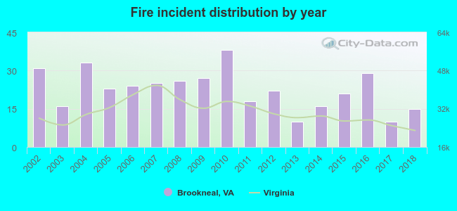
2002 - 2018 National Fire Incident Reporting System (NFIRS) incidents
Based on the data from the years 2002 - 2018 the average number of fire incidents per year is 23. The highest number of fire incidents - 38 took place in 2010, and the least - 10 in 2013. The data has a dropping trend.
When looking into fire subcategories, the most reports belonged to: Structure Fires (48.4%), and Outside Fires (39.6%).
Fire incident types reported to NFIRS in Brookneal, VA


 Recent articles from our blog. Our writers, many of them Ph.D. graduates or candidates, create easy-to-read articles on a wide variety of topics.

 (27.3 miles


 Based on the data from the years 2002 - 2018 the average number of fire incidents per year is 23. The highest number of fire incidents - 38 took place in 2010, and the least - 10 in 2013. The data has a dropping trend.
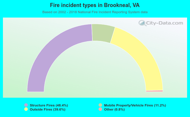 When looking into fire subcategories, the most reports belonged to: Structure Fires (48.4%), and Outside Fires (39.6%).