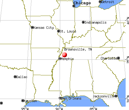
Brownsville, Tennessee
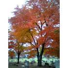
Brownsville: Halloween in Oakwood Cemetery
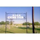
Brownsville: Zion Cemetery
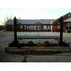
Brownsville: Three-Way Baptist Church
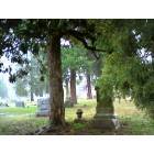
Brownsville: Oakwood Cemetery
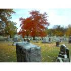
Brownsville: Oakwood Cemetery
Brownsville: Baled Cotton
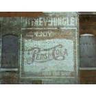
Brownsville: Uptown Brownsville
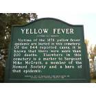
Brownsville: Yellow Fever
Brownsville: Yellow Fever Epidemic
- add
your
Submit your own pictures of this city and show them to the world
- OSM Map
- General Map
- Google Map
- MSN Map
Population change since 2000: -11.2%
 |
| Males: 4,413 | |
| Females: 5,129 |
| Median resident age: | 41.4 years |
| Tennessee median age: | 39.2 years |
Zip codes: 38012.
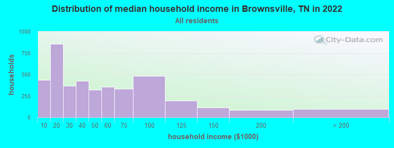
| Brownsville: | $39,398 |
| TN: | $65,254 |
Estimated per capita income in 2022: $22,791 (it was $15,217 in 2000)
Brownsville city income, earnings, and wages data
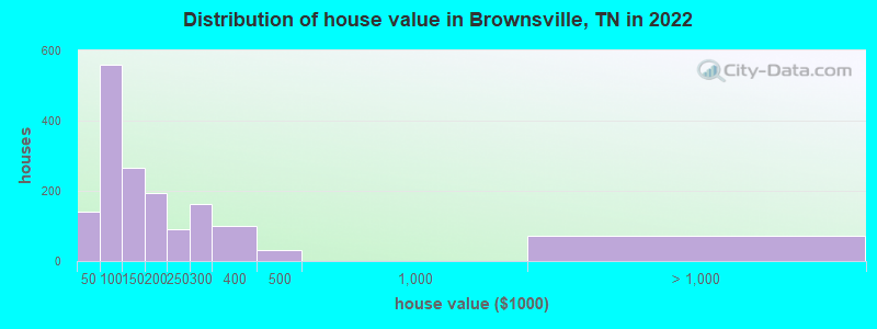
Estimated median house or condo value in 2022: $132,890 (it was $67,800 in 2000)
| Brownsville: | $132,890 |
| TN: | $284,800 |
Mean prices in 2022: all housing units: $202,632; detached houses: $206,014; townhouses or other attached units: $196,047; mobile homes: $82,229
Median gross rent in 2022: $739.
(17.7% for White Non-Hispanic residents, 33.7% for Black residents, 3.3% for Hispanic or Latino residents, 21.4% for two or more races residents)
Detailed information about poverty and poor residents in Brownsville, TN
Compare current foreclosures in Brownsville, TN:
| Photo | Address | Area | Beds / Baths | Price | Details |
|---|---|---|---|---|---|

|
#1
River Bend Rd
Brownsville, TN 38012
|
1,196 sq. feet
|
1 baths 2 beds |
$185,000
|
show details |

|
#2
N Lafayette Ave
Brownsville, TN 38012
|
1,267 sq. feet
|
1 baths - beds |
show details | |

|
#3
E Franklin St # A
Brownsville, TN 38012
|
2,580 sq. feet
|
3 baths - beds |
show details | |

|
#4
Fleming Dr
Brownsville, TN 38012
|
1,139 sq. feet
|
1 baths - beds |
show details | |

|
#5
N Park Ave
Brownsville, TN 38012
|
2,196 sq. feet
|
3 baths - beds |
show details | |

|
#6
Lark St
Brownsville, TN 38012
|
1,018 sq. feet
|
1 baths - beds |
show details | |

|
#7
Joshwood Dr
Brownsville, TN 38012
|
1,007 sq. feet
|
1 baths - beds |
show details | |

|
#8
Walnut Hill Cir
Brownsville, TN 38012
|
1,109 sq. feet
|
1 baths - beds |
show details | |

|
#9
Walnut Hill Cir
Brownsville, TN 38012
|
1,512 sq. feet
|
1 baths - beds |
show details | |

|
#10
W Thomas St
Brownsville, TN 38012
|
1,976 sq. feet
|
2 baths - beds |
show details |
| Photo | Address | Area | Beds / Baths | Price | Details |
|---|---|---|---|---|---|

|
#11
W Thomas St
Brownsville, TN 38012
|
1,037 sq. feet
|
1 baths - beds |
show details | |

|
#12
Stoots Rd
Brownsville, TN 38012
|
780 sq. feet
|
1 baths - beds |
show details | |

|
#13
Meadow St
Brownsville, TN 38012
|
1,806 sq. feet
|
1 baths - beds |
show details | |

|
#14
E Jefferson St
Brownsville, TN 38012
|
954 sq. feet
|
1 baths - beds |
show details | |

|
#15
W Thomas St
Brownsville, TN 38012
|
1,518 sq. feet
|
2 baths - beds |
show details | |

|
#16
Pat Mann Jr Ln
Brownsville, TN 38012
|
1,152 sq. feet
|
2 baths - beds |
show details | |

|
#17
S Washington Ave
Brownsville, TN 38012
|
1,368 sq. feet
|
2 baths - beds |
show details | |

|
#18
Cottonwood Dr
Brownsville, TN 38012
|
1,120 sq. feet
|
1 baths - beds |
show details | |

|
#19
N Lafayette Ave
Brownsville, TN 38012
|
750 sq. feet
|
1 baths - beds |
show details | |

|
#20
N Park Ave
Brownsville, TN 38012
|
1,963 sq. feet
|
2 baths - beds |
show details |
| Photo | Address | Area | Beds / Baths | Price | Details |
|---|---|---|---|---|---|

|
#21
Brack Rd
Brownsville, TN 38012
|
1,296 sq. feet
|
1 baths - beds |
show details | |

|
#22
Houston St
Brownsville, TN 38012
|
1,074 sq. feet
|
1 baths - beds |
show details | |

|
#23
Tisdale St
Brownsville, TN 38012
|
1,100 sq. feet
|
1 baths - beds |
show details | |

|
#24
Largo Dr
Brownsville, TN 38012
|
1,949 sq. feet
|
2 baths - beds |
show details | |

|
#25
Cottondale Dr
Brownsville, TN 38012
|
1,944 sq. feet
|
2 baths - beds |
show details | |

|
#26
Haralson St
Brownsville, TN 38012
|
1,711 sq. feet
|
1 baths - beds |
show details | |

|
#27
Burford Ave
Brownsville, TN 38012
|
1,282 sq. feet
|
1 baths - beds |
show details | |

|
#28
N Mclemore Ave
Brownsville, TN 38012
|
1,157 sq. feet
|
1 baths - beds |
show details | |

|
#29
Reed Rd
Brownsville, TN 38012
|
1,768 sq. feet
|
2 baths - beds |
show details | |

|
#30
Hatchie St
Brownsville, TN 38012
|
2,364 sq. feet
|
2 baths - beds |
show details |
| Photo | Address | Area | Beds / Baths | Price | Details |
|---|---|---|---|---|---|

|
#31
Country Lake Cir
Brownsville, TN 38012
|
3,419 sq. feet
|
3 baths - beds |
show details | |

|
#32
Tabernacle Rd
Brownsville, TN 38012
|
1,752 sq. feet
|
2 baths - beds |
show details | |

|
#33
N Wilson Ave
Brownsville, TN 38012
|
2,315 sq. feet
|
3 baths - beds |
show details | |

|
#34
S Russell St
Brownsville, TN 38012
|
949 sq. feet
|
2 baths - beds |
show details | |

|
#35
Dogwood St
Brownsville, TN 38012
|
1,029 sq. feet
|
1 baths - beds |
show details | |

|
#36
Bellanti Cir
Brownsville, TN 38012
|
980 sq. feet
|
1 baths - beds |
show details | |

|
#37
Lark St
Brownsville, TN 38012
|
1,145 sq. feet
|
1 baths - beds |
show details | |

|
#38
Keith St
Brownsville, TN 38012
|
912 sq. feet
|
1 baths - beds |
show details | |

|
#39
Dixie Ave
Brownsville, TN 38012
|
1,608 sq. feet
|
2 baths - beds |
show details | |

|
#40
Hickory Grove Rd
Brownsville, TN 38012
|
1,205 sq. feet
|
1 baths - beds |
show details |
| Photo | Address | Area | Beds / Baths | Price | Details |
|---|---|---|---|---|---|

|
#41
Fleming Dr
Brownsville, TN 38012
|
925 sq. feet
|
1 baths - beds |
show details | |

|
#42
Stoots Rd
Brownsville, TN 38012
|
1,736 sq. feet
|
2 baths - beds |
show details | |

|
#43
Breckenridge St
Brownsville, TN 38012
|
2,062 sq. feet
|
2 baths - beds |
show details | |

|
#44
Meadow St
Brownsville, TN 38012
|
1,525 sq. feet
|
2 baths - beds |
show details | |

|
#45
Sunlyn St
Brownsville, TN 38012
|
1,693 sq. feet
|
2 baths - beds |
show details | |

|
#46
Penny Cv
Brownsville, TN 38012
|
1,476 sq. feet
|
2 baths - beds |
show details | |

|
#47
Margin St
Brownsville, TN 38012
|
868 sq. feet
|
1 baths - beds |
show details | |

|
#48
Locust Dr
Brownsville, TN 38012
|
1,090 sq. feet
|
1 baths - beds |
show details | |

|
#49
Morning Dr
Brownsville, TN 38012
|
1,260 sq. feet
|
2 baths - beds |
show details | |

|
Check over 1 million property listings on Foreclosure.com!
|
browse all offers | |||


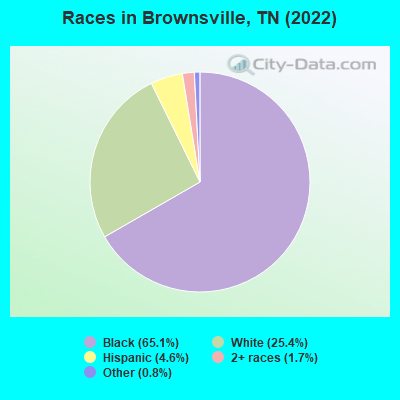
- 6,45865.1%Black alone
- 2,51525.4%White alone
- 4584.6%Hispanic
- 1731.7%Two or more races
- 820.8%Other race alone
Races in Brownsville detailed stats: ancestries, foreign born residents, place of birth
According to our research of Tennessee and other state lists, there were 50 registered sex offenders living in Brownsville, Tennessee as of April 27, 2024.
The ratio of all residents to sex offenders in Brownsville is 202 to 1.
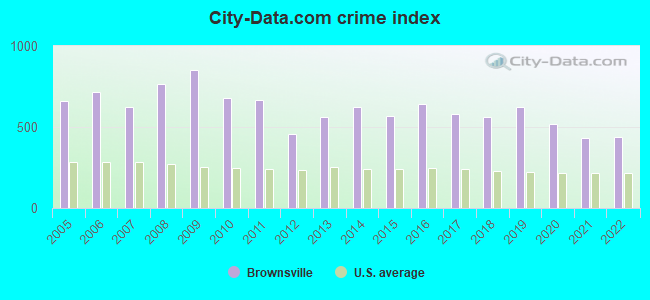
Type |
2009 |
2010 |
2011 |
2012 |
2013 |
2014 |
2015 |
2016 |
2017 |
2018 |
2019 |
2020 |
2021 |
2022 |
|---|---|---|---|---|---|---|---|---|---|---|---|---|---|---|
| Murders (per 100,000) | 2 (19.5) | 1 (9.7) | 1 (9.6) | 0 (0.0) | 1 (10.1) | 3 (30.1) | 1 (10.1) | 1 (10.2) | 2 (20.6) | 2 (21.1) | 2 (21.4) | 1 (10.7) | 1 (11.0) | 2 (20.9) |
| Rapes (per 100,000) | 11 (107.1) | 8 (77.7) | 8 (77.0) | 3 (29.4) | 5 (50.6) | 6 (60.3) | 8 (80.8) | 6 (61.3) | 11 (113.4) | 13 (137.0) | 13 (139.2) | 5 (53.5) | 5 (54.8) | 4 (41.8) |
| Robberies (per 100,000) | 20 (194.8) | 20 (194.3) | 15 (144.4) | 8 (78.4) | 10 (101.2) | 13 (130.6) | 12 (121.2) | 16 (163.3) | 10 (103.1) | 7 (73.8) | 9 (96.4) | 9 (96.4) | 2 (21.9) | 5 (52.2) |
| Assaults (per 100,000) | 169 (1,646) | 135 (1,312) | 129 (1,242) | 101 (990.1) | 120 (1,214) | 120 (1,205) | 102 (1,031) | 142 (1,450) | 99 (1,021) | 88 (927.3) | 127 (1,360) | 117 (1,253) | 97 (1,063) | 109 (1,138) |
| Burglaries (per 100,000) | 245 (2,386) | 200 (1,943) | 235 (2,263) | 141 (1,382) | 137 (1,386) | 113 (1,135) | 120 (1,212) | 120 (1,225) | 91 (938.3) | 107 (1,128) | 63 (674.8) | 80 (856.5) | 62 (679.2) | 45 (469.8) |
| Thefts (per 100,000) | 384 (3,740) | 320 (3,109) | 347 (3,341) | 271 (2,657) | 304 (3,075) | 312 (3,133) | 345 (3,486) | 324 (3,308) | 308 (3,176) | 265 (2,792) | 249 (2,667) | 220 (2,355) | 176 (1,928) | 159 (1,660) |
| Auto thefts (per 100,000) | 26 (253.2) | 21 (204.0) | 5 (48.1) | 12 (117.6) | 7 (70.8) | 39 (391.7) | 18 (181.9) | 17 (173.6) | 23 (237.2) | 13 (137.0) | 15 (160.7) | 23 (246.3) | 24 (262.9) | 24 (250.6) |
| Arson (per 100,000) | 3 (29.2) | 1 (9.7) | 2 (19.3) | 2 (19.6) | 2 (20.2) | 6 (60.3) | 3 (30.3) | 2 (20.4) | 1 (10.3) | 4 (42.1) | 0 (0.0) | 1 (10.7) | 2 (21.9) | 0 (0.0) |
| City-Data.com crime index | 849.2 | 679.0 | 668.6 | 457.5 | 559.5 | 624.8 | 566.2 | 640.3 | 578.8 | 560.9 | 622.0 | 517.6 | 430.5 | 437.8 |
The City-Data.com crime index weighs serious crimes and violent crimes more heavily. Higher means more crime, U.S. average is 246.1. It adjusts for the number of visitors and daily workers commuting into cities.
Crime rate in Brownsville detailed stats: murders, rapes, robberies, assaults, burglaries, thefts, arson
Full-time law enforcement employees in 2021, including police officers: 40 (34 officers - 31 male; 3 female).
| Officers per 1,000 residents here: | 3.72 |
| Tennessee average: | 2.57 |
 Recent articles from our blog. Our writers, many of them Ph.D. graduates or candidates, create easy-to-read articles on a wide variety of topics.

 | Cookeville has "model downtown" (207 replies) |
| New metro area definitions and populations (19 replies) |
| Tennessee's 2020 Census results (70 replies) |
| Not many retirement threads on Western Tennessee? (13 replies) |
| Visiting tn for the first time next summer what do y’all recommend (5 replies) |
| Month long road trip -(Dec-Jan) . (12 replies) |
Latest news from Brownsville, TN collected exclusively by city-data.com from local newspapers, TV, and radio stations
Ancestries: American (3.3%), English (3.1%), African (1.4%), German (1.3%), Scottish (1.2%).
Current Local Time: CST time zone
Incorporated in 1870
Elevation: 390 feet
Land area: 9.12 square miles.
Population density: 1,046 people per square mile (low).
273 residents are foreign born (1.7% Latin America, 0.6% Asia, 0.3% Europe).
| This city: | 2.8% |
| Tennessee: | 5.4% |
Median real estate property taxes paid for housing units with mortgages in 2022: $1,166 (0.8%)
Median real estate property taxes paid for housing units with no mortgage in 2022: $1,039 (0.9%)
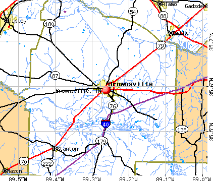
Nearest city with pop. 50,000+: Jackson, TN  (24.9 miles , pop. 59,643).
Nearest city with pop. 200,000+: Memphis, TN (51.7 miles , pop. 650,100).
Nearest city with pop. 1,000,000+: Chicago, IL (440.6 miles , pop. 2,896,016).
Nearest cities:
), ), ), ), ), )Latitude: 35.59 N, Longitude: 89.26 W
Daytime population change due to commuting: +143 (+1.4%)
Workers who live and work in this city: 2,087 (51.9%)
Area code: 731
Brownsville, Tennessee accommodation & food services, waste management - Economy and Business Data
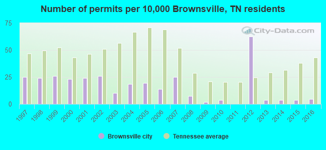
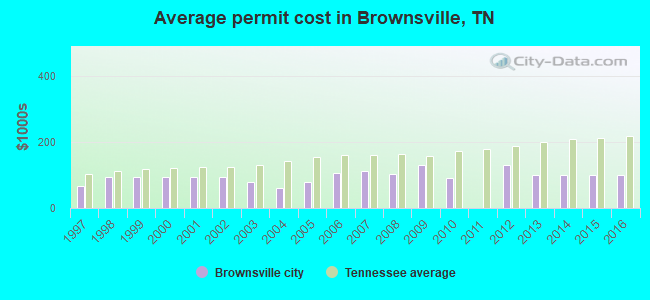
Single-family new house construction building permits:
- 2016: 5 buildings, average cost: $100,700
- 2015: 4 buildings, average cost: $100,700
- 2014: 4 buildings, average cost: $100,700
- 2013: 4 buildings, average cost: $100,700
- 2012: 67 buildings, average cost: $128,800
- 2010: 4 buildings, average cost: $90,800
- 2009: 2 buildings, average cost: $129,200
- 2008: 8 buildings, average cost: $101,900
- 2007: 27 buildings, average cost: $111,100
- 2006: 15 buildings, average cost: $106,100
- 2005: 21 buildings, average cost: $77,800
- 2004: 20 buildings, average cost: $60,100
- 2003: 11 buildings, average cost: $79,300
- 2002: 28 buildings, average cost: $94,200
- 2001: 26 buildings, average cost: $94,200
- 2000: 25 buildings, average cost: $94,200
- 1999: 28 buildings, average cost: $94,200
- 1998: 26 buildings, average cost: $94,200
- 1997: 27 buildings, average cost: $68,000
| Here: | 4.0% |
| Tennessee: | 3.0% |
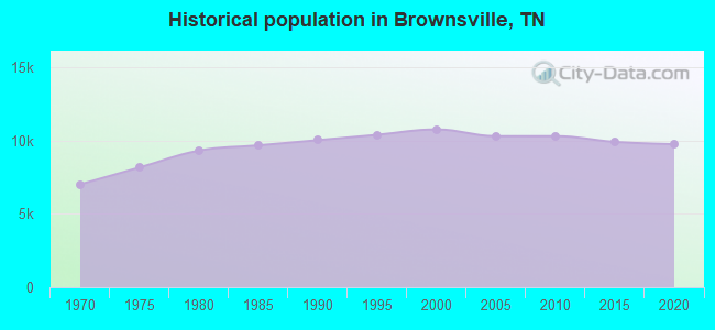
Population change in the 1990s: +305 (+2.9%).
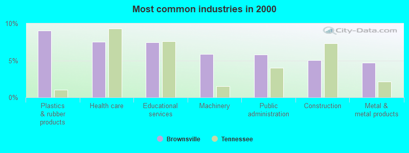
- Plastics & rubber products (9.1%)
- Health care (7.5%)
- Educational services (7.4%)
- Machinery (5.8%)
- Public administration (5.8%)
- Construction (5.1%)
- Metal & metal products (4.7%)
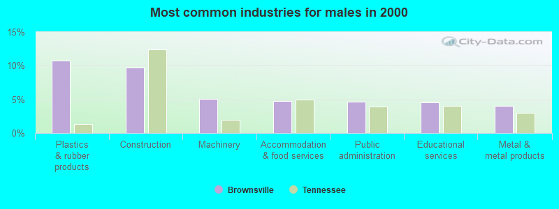
- Plastics & rubber products (10.7%)
- Construction (9.7%)
- Machinery (5.1%)
- Accommodation & food services (4.7%)
- Public administration (4.6%)
- Educational services (4.5%)
- Metal & metal products (4.0%)
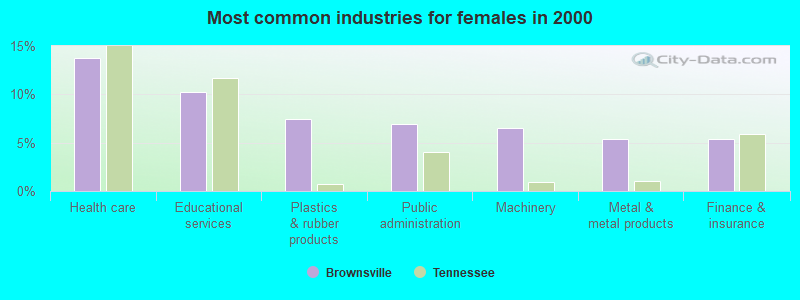
- Health care (13.8%)
- Educational services (10.2%)
- Plastics & rubber products (7.5%)
- Public administration (6.9%)
- Machinery (6.5%)
- Metal & metal products (5.4%)
- Finance & insurance (5.3%)
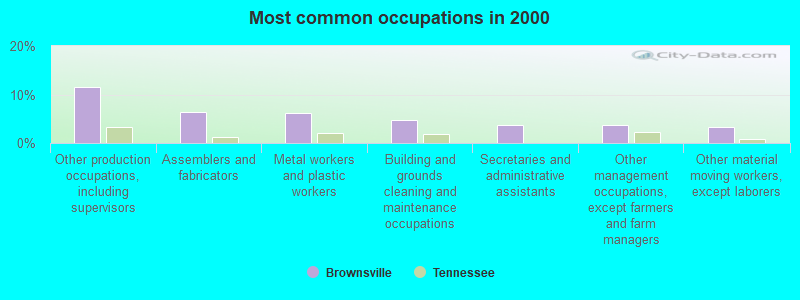
- Other production occupations, including supervisors (11.6%)
- Assemblers and fabricators (6.4%)
- Metal workers and plastic workers (6.2%)
- Building and grounds cleaning and maintenance occupations (4.7%)
- Secretaries and administrative assistants (3.7%)
- Other management occupations, except farmers and farm managers (3.7%)
- Other material moving workers, except laborers (3.2%)
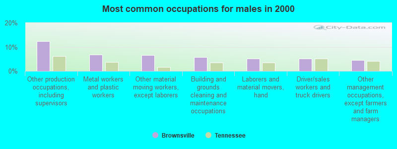
- Other production occupations, including supervisors (12.3%)
- Metal workers and plastic workers (6.7%)
- Other material moving workers, except laborers (6.7%)
- Building and grounds cleaning and maintenance occupations (5.9%)
- Laborers and material movers, hand (5.2%)
- Driver/sales workers and truck drivers (5.1%)
- Other management occupations, except farmers and farm managers (4.5%)
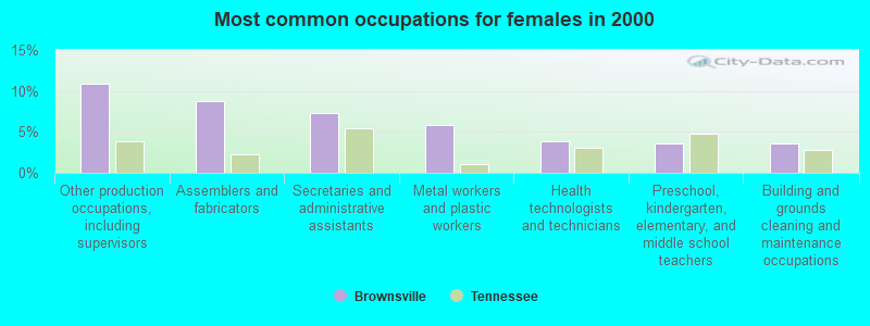
- Other production occupations, including supervisors (10.9%)
- Assemblers and fabricators (8.8%)
- Secretaries and administrative assistants (7.3%)
- Metal workers and plastic workers (5.8%)
- Health technologists and technicians (3.8%)
- Preschool, kindergarten, elementary, and middle school teachers (3.5%)
- Building and grounds cleaning and maintenance occupations (3.5%)
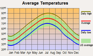
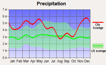
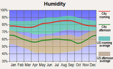
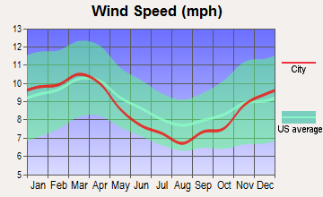
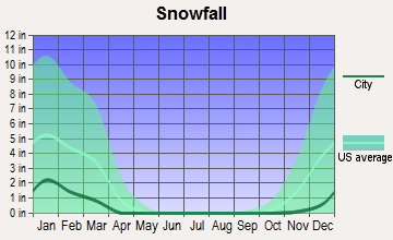
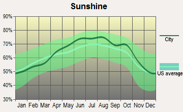
Average climate in Brownsville, Tennessee
Based on data reported by over 4,000 weather stations

|
|

(lower is better)
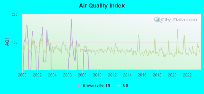
Air Quality Index (AQI) level in 2008 was 66.5. This is about average.
| City: | 66.5 |
| U.S.: | 72.6 |
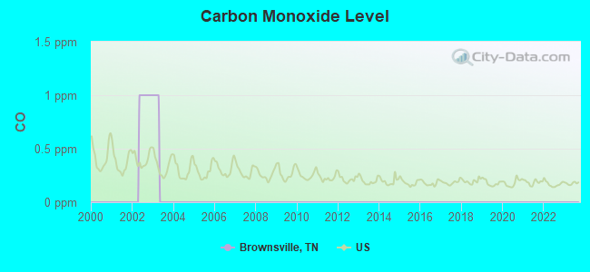
Carbon Monoxide (CO) [ppm] level in 2002 was 1.00. This is significantly worse than average. Closest monitor was 9.8 miles away from the city center.
| City: | 1.00 |
| U.S.: | 0.25 |
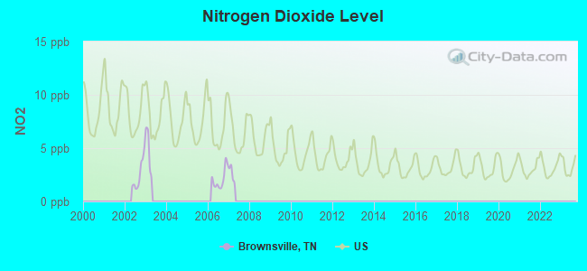
Nitrogen Dioxide (NO2) [ppb] level in 2006 was 2.09. This is significantly better than average. Closest monitor was 9.8 miles away from the city center.
| City: | 2.09 |
| U.S.: | 5.11 |
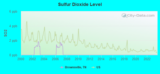
Sulfur Dioxide (SO2) [ppb] level in 2006 was 1.24. This is better than average. Closest monitor was 9.8 miles away from the city center.
| City: | 1.24 |
| U.S.: | 1.51 |
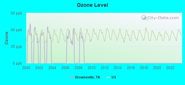
Ozone [ppb] level in 2008 was 31.4. This is about average. Closest monitor was 9.8 miles away from the city center.
| City: | 31.4 |
| U.S.: | 33.3 |
Tornado activity:
Brownsville-area historical tornado activity is above Tennessee state average. It is 105% greater than the overall U.S. average.
On 5/4/2003, a category F4 (max. wind speeds 207-260 mph) tornado 13.9 miles away from the Brownsville city center killed 11 people and injured 86 people and caused $40 million in damages.
On 1/17/1999, a category F4 tornado 21.4 miles away from the city center killed 6 people and injured 106 people and caused $10 million in damages.
Earthquake activity:
Brownsville-area historical earthquake activity is significantly above Tennessee state average. It is 359% greater than the overall U.S. average.On 3/25/1976 at 00:41:20, a magnitude 5.0 (4.9 MB, 5.0 LG, Class: Moderate, Intensity: VI - VII) earthquake occurred 60.0 miles away from the city center
On 5/4/1991 at 01:18:54, a magnitude 5.0 (4.4 MB, 4.6 LG, 5.0 LG, Depth: 3.1 mi) earthquake occurred 74.3 miles away from Brownsville center
On 4/27/1989 at 16:47:49, a magnitude 4.7 (4.6 MB, 4.7 LG, 4.3 LG, Class: Light, Intensity: IV - V) earthquake occurred 40.4 miles away from the city center
On 9/26/1990 at 13:18:51, a magnitude 5.0 (4.7 MB, 4.8 LG, 5.0 LG, Depth: 7.7 mi) earthquake occurred 110.1 miles away from the city center
On 4/18/2008 at 09:36:59, a magnitude 5.4 (5.1 MB, 4.8 MS, 5.4 MW, 5.2 MW) earthquake occurred 212.0 miles away from Brownsville center
On 4/18/2008 at 09:36:59, a magnitude 5.2 (5.2 MW, Depth: 8.9 mi) earthquake occurred 211.9 miles away from the city center
Magnitude types: regional Lg-wave magnitude (LG), body-wave magnitude (MB), surface-wave magnitude (MS), moment magnitude (MW)
Natural disasters:
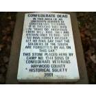
The number of natural disasters in Haywood County (13) is near the US average (15).Major Disasters (Presidential) Declared: 11
Emergencies Declared: 1
Causes of natural disasters: Storms: 9, Floods: 7, Tornadoes: 7, Winds: 5, Winter Storms: 2, Flash Flood: 1, Hurricane: 1, Ice Storm: 1, Other: 1 (Note: some incidents may be assigned to more than one category).
Hospitals and medical centers in Brownsville:
Heliports located in Brownsville:
Colleges/universities with over 2000 students nearest to Brownsville:
- Union University (about 24 miles; Jackson, TN; Full-time enrollment: 4,051)
- Jackson State Community College (about 28 miles; Jackson, TN; FT enrollment: 2,958)
- Dyersburg State Community College (about 33 miles; Dyersburg, TN; FT enrollment: 2,211)
- Rhodes College (about 51 miles; Memphis, TN; FT enrollment: 2,052)
- University of Memphis (about 53 miles; Memphis, TN; FT enrollment: 17,427)
- Southwest Tennessee Community College (about 54 miles; Memphis, TN; FT enrollment: 8,043)
- The University of Tennessee-Martin (about 57 miles; Martin, TN; FT enrollment: 7,013)
Public high school in Brownsville:
- HAYWOOD HIGH SCHOOL (Students: 983, Location: 1175 E COLLEGE, Grades: 9-12)
Public elementary/middle schools in Brownsville:
- HAYWOOD ELEMENTARY (Students: 575, Location: 313 N GRAND AV, Grades: 1-3)
- EAST SIDE ELEMENTARY (Location: 1315 EAST JEFFERSON, Grades: 4-5)
- HAYWOOD MIDDLE SCHOOL (Location: 1201 HARALSON, Grades: 6-8)
User-submitted facts and corrections:
- Brownsville has a new physical therapy clinic opening... PT COMPANY. It will be an outpatient physical therapy clinic at 144 South Dupree St. Phone: 731.772.5213 Fax: 731.772.8209
Points of interest:
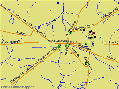
Notable locations in Brownsville: Brownsville Fire Department Station 3 (A), Haywood County Jail (B), Brownsville City Hall (C), Brownsville Fire Department Station 2 (D), Brownsville Fire Department Station 1 (E), Haywood County Courthouse (F), College Hill Community Center (G), Brownsville-Haywood County Library (H), Haywood County Ambulance Authority (I). Display/hide their locations on the map
Shopping Center: Bradford Square Shopping Center (1). Display/hide its location on the map
Churches in Brownsville include: Brownsville Baptist Church (A), Temple Adas Israel (B), Zion Church (C), Saint Johns Roman Catholic Church (D), First Presbyterian Church of Brownsville (E), First Methodist Church (F), First Baptist Church of Brownsville (G), Farmers Chapel Christian Methodist Episcopal Church (H), Church of God in Christ (I). Display/hide their locations on the map
Cemeteries: Israel Cemetery (1), Knights of Pythias Cemetery (2), Magnolia Cemetery (3), Richards Cemetery (4), Oakwood Cemetery (5), Rosenwald Cemetery (6). Display/hide their locations on the map
Reservoir: B W Cobb Lake (A). Display/hide its location on the map
Parks in Brownsville include: Bomer City Park (1), College Hill Historic District (2). Display/hide their locations on the map
Hotels: Comfort Inn (2600 Anderson Ave), Days Inn of Brownsville (2530 Anderson Avenue), Best Western Traveller's Inn (110 Sunny Hill Cove), Comfort Inn Brownsville (2600 Anderson Avenue), Brownsville-Days Inn (2530 Anderson Avenue), Best Western Travellers Inn (110 Sunnyhill Cove).
Courts: Haywood County - General Sessions Court Clerk (11 South Lafayette Avenue), Haywood County - County Clerk- Juvenile Court Clerk (1 North Washington Avenue), Haywood County - Circuit Court Clerk- General Sessions Court (Court House), Haywood County - Chancery Court Clerk (Court House).
Birthplace of: Richard Halliburton - Travel writer, Corey Moore - College football player, Jarvis Varnado - Basketball player, Yank Rachell - Country blues musician, Craig Harris - College football player (Middle Tenn. St. Blue Raiders), Hammie Nixon - Blues harmonica player, Leslie Delk - College basketball player (South Alabama Jaguars), Vic Bradford - Major League Baseball player.
Drinking water stations with addresses in Brownsville and their reported violations in the past:
BROWNSVILLE WATER DEPT (Population served: 13,545, Groundwater):Past monitoring violations:HAYWOOD CO. UTILITY DISTRICT (Population served: 1,343, Purch groundwater):
- Monitoring, Repeat Major (TCR) - In MAY-2007, Contaminant: Coliform (TCR). Follow-up actions: St Compliance achieved (JUN-01-2007), St Public Notif requested (JUL-03-2007), St Violation/Reminder Notice (JUL-03-2007), St Public Notif received (MAY-28-2008)
- Monitoring and Reporting (DBP) - Between APR-2007 and JUN-2007, Contaminant: Chlorine. Follow-up actions: St Compliance achieved (JUL-01-2007), St Public Notif requested (JUL-03-2007), St Violation/Reminder Notice (JUL-03-2007), St Public Notif received (MAY-28-2008)
Past monitoring violations:STANTON WATER SYSTEM (Population served: 688, Groundwater):
- Monitoring and Reporting (DBP) - Between JUL-2010 and SEP-2010, Contaminant: Chlorine. Follow-up actions: St Public Notif requested (AUG-31-2010), St Violation/Reminder Notice (AUG-31-2010), St Compliance achieved (DEC-31-2010)
- Monitoring and Reporting (DBP) - Between JAN-2009 and MAR-2009, Contaminant: Chlorine. Follow-up actions: St Public Notif requested (MAR-03-2009), St Violation/Reminder Notice (MAR-03-2009), St Compliance achieved (JUN-30-2009)
- One routine major monitoring violation
- One minor monitoring violation
Past monitoring violations:ZION BAPTIST CHURCH (Population served: 100, Groundwater):
- Monitoring and Reporting (DBP) - Between APR-2007 and JUN-2007, Contaminant: Chlorine. Follow-up actions: St Public Notif requested (MAY-31-2007), St Violation/Reminder Notice (MAY-31-2007), St Compliance achieved (JUL-01-2007)
- Follow-up Or Routine LCR Tap M/R - In JUL-01-1996, Contaminant: Lead and Copper Rule. Follow-up actions: St Intentional no-action (DEC-31-2003)
- One routine major monitoring violation
Past monitoring violations:
- One routine major monitoring violation
| This city: | 2.5 people |
| Tennessee: | 2.5 people |
| This city: | 66.1% |
| Whole state: | 67.3% |
| This city: | 5.2% |
| Whole state: | 5.8% |
Likely homosexual households (counted as self-reported same-sex unmarried-partner households)
- Lesbian couples: 0.2% of all households
- Gay men: 0.2% of all households
158 people in nursing homes in 2000
19 people in other noninstitutional group quarters in 2000
Banks with branches in Brownsville (2011 data):
- INSOUTH Bank: Peachtree Plaza Branch, Holly Park Branch, Insouth Bank. Info updated 2006/11/03: Bank assets: $290.2 mil, Deposits: $267.7 mil, local headquarters, negative income in the last year, Commercial Lending Specialization, 7 total offices, Holding Company: Independent Southern Bancshares, Inc. Esot
- First South Bank: West Main Branch at 308 West Main, branch established on 1998/12/21; East Brownsville Branch at 1519 East Main Street, branch established on 2005/11/30. Info updated 2007/01/10: Bank assets: $437.6 mil, Deposits: $357.5 mil, headquarters in Jackson, TN, positive income, Commercial Lending Specialization, 10 total offices, Holding Company: Hardeman County Investment Company, Inc.
- First State Bank: at 25 South Grand Avenue, branch established on 2006/09/08. Info updated 2006/11/03: Bank assets: $1,646.2 mil, Deposits: $1,393.0 mil, headquarters in Union City, TN, positive income, Commercial Lending Specialization, 32 total offices, Holding Company: Community First Bancshares, Inc.
- Regions Bank: Brownsville Branch at 1028 East Main St, branch established on 1976/12/14. Info updated 2011/02/24: Bank assets: $123,368.2 mil, Deposits: $98,301.3 mil, headquarters in Birmingham, AL, positive income, Commercial Lending Specialization, 1778 total offices, Holding Company: Regions Financial Corporation
For population 15 years and over in Brownsville:
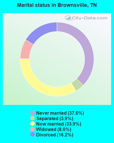
- Never married: 37.5%
- Now married: 33.9%
- Separated: 3.9%
- Widowed: 8.6%
- Divorced: 16.2%
For population 25 years and over in Brownsville:
- High school or higher: 82.3%
- Bachelor's degree or higher: 9.4%
- Graduate or professional degree: 3.6%
- Unemployed: 7.7%
- Mean travel time to work (commute): 20.9 minutes
| Here: | 8.7 |
| Tennessee average: | 11.4 |

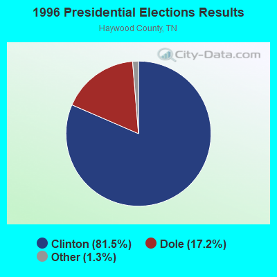
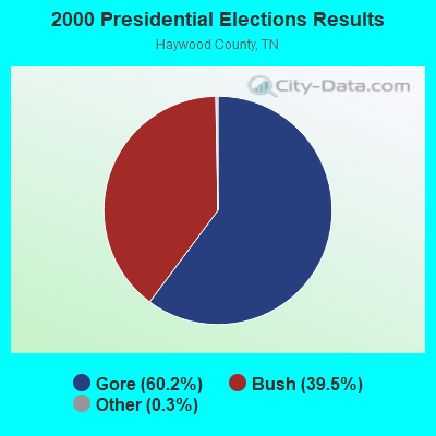
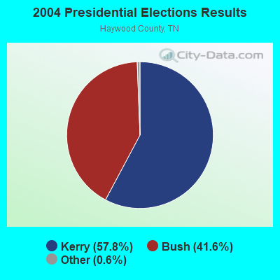

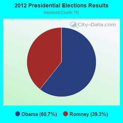
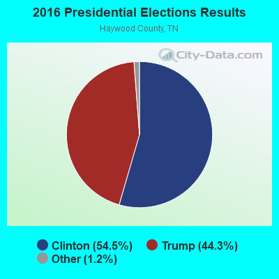
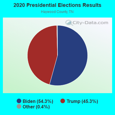
Graphs represent county-level data. Detailed 2008 Election Results
Religion statistics for Brownsville, TN (based on Haywood County data)
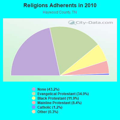
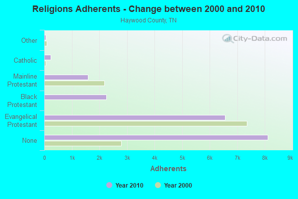
| Religion | Adherents | Congregations |
|---|---|---|
| Evangelical Protestant | 6,552 | 25 |
| Black Protestant | 2,245 | 15 |
| Mainline Protestant | 1,583 | 15 |
| Catholic | 232 | 1 |
| Other | 62 | 2 |
| None | 8,113 | - |
Food Environment Statistics:
| Haywood County: | 1.57 / 10,000 pop. |
| State: | 1.99 / 10,000 pop. |
| This county: | 0.52 / 10,000 pop. |
| Tennessee: | 0.65 / 10,000 pop. |
| Here: | 6.27 / 10,000 pop. |
| State: | 5.16 / 10,000 pop. |
| Here: | 4.18 / 10,000 pop. |
| Tennessee: | 6.56 / 10,000 pop. |
| This county: | 12.7% |
| Tennessee: | 11.4% |
| Haywood County: | 35.4% |
| State: | 30.2% |
| Here: | 13.3% |
| Tennessee: | 13.5% |
Health and Nutrition:
| Here: | 47.9% |
| Tennessee: | 49.3% |
| This city: | 44.8% |
| Tennessee: | 46.1% |
| This city: | 30.0 |
| Tennessee: | 28.8 |
| Brownsville: | 19.6% |
| Tennessee: | 21.0% |
| Brownsville: | 13.5% |
| Tennessee: | 10.5% |
| This city: | 6.7 |
| State: | 6.8 |
| Brownsville: | 36.2% |
| Tennessee: | 33.9% |
| This city: | 53.7% |
| Tennessee: | 55.9% |
| Brownsville: | 81.0% |
| Tennessee: | 79.1% |
More about Health and Nutrition of Brownsville, TN Residents
| Local government employment and payroll (March 2022) | |||||
| Function | Full-time employees | Monthly full-time payroll | Average yearly full-time wage | Part-time employees | Monthly part-time payroll |
|---|---|---|---|---|---|
| Police Protection - Officers | 36 | $133,445 | $44,482 | 0 | $0 |
| Firefighters | 26 | $82,237 | $37,956 | 0 | $0 |
| Other and Unallocable | 22 | $57,428 | $31,324 | 1 | $219 |
| Solid Waste Management | 18 | $42,643 | $28,429 | 0 | $0 |
| Streets and Highways | 17 | $41,397 | $29,221 | 0 | $0 |
| Financial Administration | 6 | $17,610 | $35,220 | 0 | $0 |
| Police - Other | 6 | $16,855 | $33,710 | 0 | $0 |
| Other Government Administration | 6 | $13,688 | $27,376 | 0 | $0 |
| Parks and Recreation | 4 | $10,203 | $30,609 | 1 | $1,151 |
| Health | 4 | $10,267 | $30,801 | 0 | $0 |
| Sewerage | 2 | $11,999 | $71,994 | 0 | $0 |
| Judicial and Legal | 2 | $2,207 | $13,242 | 0 | $0 |
| Totals for Government | 149 | $439,979 | $35,435 | 2 | $1,371 |
Brownsville government finances - Expenditure in 2021 (per resident):
- Construction - Regular Highways: $103,000 ($10.79)
Parks and Recreation: $8,000 ($0.84)
- Current Operations - Police Protection: $2,067,000 ($216.62)
Local Fire Protection: $1,257,000 ($131.73)
Solid Waste Management: $709,000 ($74.30)
General - Other: $656,000 ($68.75)
Regular Highways: $631,000 ($66.13)
Central Staff Services: $439,000 ($46.01)
Protective Inspection and Regulation - Other: $195,000 ($20.44)
Parks and Recreation: $157,000 ($16.45)
Health - Other: $122,000 ($12.79)
Correctional Institutions: $100,000 ($10.48)
Sewerage: $81,000 ($8.49)
General Public Buildings: $62,000 ($6.50)
Financial Administration: $43,000 ($4.51)
Miscellaneous Commercial Activities - Other: $30,000 ($3.14)
Judicial and Legal Services: $26,000 ($2.72)
- Intergovernmental to Local - Other - Parks and Recreation: $376,000 ($39.40)
Other - Electric Utilities: $133,000 ($13.94)
Other - Correctional Institutions: $100,000 ($10.48)
Other - Libraries: $78,000 ($8.17)
- Other Capital Outlay - Regular Highways: $122,000 ($12.79)
Police Protection: $64,000 ($6.71)
Solid Waste Management: $56,000 ($5.87)
Local Fire Protection: $53,000 ($5.55)
Central Staff Services: $51,000 ($5.34)
General - Other: $21,000 ($2.20)
Miscellaneous Commercial Activities - Other: $15,000 ($1.57)
Health - Other: $12,000 ($1.26)
- Total Salaries and Wages: $7,082,000 ($742.19)
Brownsville government finances - Revenue in 2021 (per resident):
- Charges - Sewerage: $2,127,000 ($222.91)
- Federal Intergovernmental - Health and Hospitals: $52,000 ($5.45)
Housing and Community Development: $8,000 ($0.84)
- Local Intergovernmental - General Local Government Support: $1,116,000 ($116.96)
Other: $784,000 ($82.16)
Electric Utilities: $456,000 ($47.79)
Highways: $385,000 ($40.35)
Gas Utilities: $34,000 ($3.56)
- Miscellaneous - Fines and Forfeits: $67,000 ($7.02)
Interest Earnings: $7,000 ($0.73)
- Revenue - Water Utilities: $45,000 ($4.72)
Gas Utilities: $34,000 ($3.56)
- State Intergovernmental - Highways: $227,000 ($23.79)
Public Welfare: $142,000 ($14.88)
Housing and Community Development: $9,000 ($0.94)
- Tax - Property: $3,628,000 ($380.21)
General Sales and Gross Receipts: $1,939,000 ($203.21)
Alcoholic Beverage Sales: $434,000 ($45.48)
Public Utilities Sales: $74,000 ($7.76)
Other Selective Sales: $42,000 ($4.40)
Motor Vehicle License: $41,000 ($4.30)
Alcoholic Beverage License: $2,000 ($0.21)
Brownsville government finances - Cash and Securities in 2021 (per resident):
- Other Funds - Cash and Securities: $6,844,000 ($717.25)
| Businesses in Brownsville, TN | ||||
| Name | Count | Name | Count | |
|---|---|---|---|---|
| AT&T | 1 | La-Z-Boy | 1 | |
| AutoZone | 1 | McDonald's | 1 | |
| Burger King | 1 | Pizza Hut | 1 | |
| Chevrolet | 1 | SONIC Drive-In | 1 | |
| Comfort Inn | 1 | Subway | 2 | |
| Dairy Queen | 1 | Taco Bell | 1 | |
| Domino's Pizza | 1 | U-Haul | 2 | |
| Econo Lodge | 1 | UPS | 1 | |
| FedEx | 2 | Walgreens | 1 | |
| H&R Block | 1 | Walmart | 1 | |
| KFC | 1 | YMCA | 1 | |
Strongest AM radio stations in Brownsville:
- WNWS (1520 AM; daytime; 0 kW; BROWNSVILLE, TN; Owner: THE WIRELESS GROUP INC.)
- WCRV (640 AM; 50 kW; COLLIERVILLE, TN; Owner: BOTT BROADCASTING COMPANY/TENNESSEE)
- WGSF (1030 AM; 50 kW; MEMPHIS, TN; Owner: FLINN BROADCASTING CORPORATION)
- WMQM (1600 AM; 50 kW; LAKELAND, TN; Owner: WMQM, INC.)
- WDIA (1070 AM; 50 kW; MEMPHIS, TN; Owner: CLEAR CHANNEL BROADCASTING LICENSES, INC.)
- WTJS (1390 AM; 5 kW; JACKSON, TN; Owner: CAPSTAR TX LIMITED PARTNERSHIP)
- WDXI (1310 AM; 5 kW; JACKSON, TN; Owner: LIBERTY RADIO II, INC.)
- WJCE (680 AM; 10 kW; MEMPHIS, TN; Owner: ENTERCOM MEMPHIS LICENSE, LLC)
- KWAM (990 AM; 10 kW; MEMPHIS, TN; Owner: CONCORD MEDIA GROUP, INC.)
- WCPC (940 AM; 50 kW; HOUSTON, MS; Owner: WCPC BROADCASTING CO., INC.)
- WSM (650 AM; 50 kW; NASHVILLE, TN; Owner: GAYLORD ENTERTAINMENT COMPANY)
- WHBQ (560 AM; 5 kW; MEMPHIS, TN; Owner: FLINN BROADCASTING CORPORATION)
- WPLX (1170 AM; 10 kW; GERMANTOWN, TN; Owner: EDUCATIONAL MEDIA FOUNDATION)
Strongest FM radio stations in Brownsville:
- WTBG (95.3 FM; BROWNSVILLE, TN; Owner: THE WIRELESS GROUP, INC.)
- WWGM (93.1 FM; ALAMO, TN; Owner: GRACE BROADCASTING SERVICES, INC.)
- WTNV (104.1 FM; JACKSON, TN; Owner: CAPSTAR TX LIMITED PARTNERSHIP)
- WYNU (92.3 FM; MILAN, TN; Owner: CAPSTAR TX LIMITED PARTNERSHIP)
- WAPO (90.5 FM; MOUNT VERNON, IL; Owner: AMERICAN FAMILY ASSOCIATION)
- WAUV (89.7 FM; RIPLEY, TN; Owner: AMERICAN FAMILY ASSOCIATION)
- WSRR-FM (98.1 FM; MILLINGTON, TN; Owner: KOOL BROADCASTING, INC.)
- WWYN (106.9 FM; MCKENZIE, TN; Owner: RAINBOW MEDIA, INC.)
- WEGR (102.7 FM; MEMPHIS, TN; Owner: CLEAR CHANNEL BROADCASTING LICENSES, INC.)
- WKNP (90.1 FM; JACKSON, TN; Owner: MID-SOUTH PUBLIC COMMUNICTNS FOUNDTN)
- WMXX-FM (103.1 FM; JACKSON, TN; Owner: GERALD W. HUNT)
- WGKX (105.9 FM; MEMPHIS, TN; Owner: KIX BROADCASTING, INC.)
- WRVR-FM (104.5 FM; MEMPHIS, TN; Owner: ENTERCOM MEMPHIS LICENSE, LLC)
- WKVZ (94.9 FM; RIPLEY, TN; Owner: EDUCATIONAL MEDIA FOUNDATION)
- WASL (100.1 FM; DYERSBURG, TN; Owner: DR PEPPER PEPSI-COLA BOTTLING CO.)
- WKBQ (93.5 FM; COVINGTON, TN; Owner: COVINGTON BROADCASTING, INC.)
TV broadcast stations around Brownsville:
- WJKT (Channel 16; JACKSON, TN; Owner: CLEAR CHANNEL BROADCASTING LICENSES, INC.)
- WBBJ-TV (Channel 7; JACKSON, TN; Owner: TENNESSEE BROADCASTING PARTNERS)
- WMC-TV (Channel 5; MEMPHIS, TN; Owner: RAYCOM AMERICA, INC.)
- W25BY (Channel 25; JACKSON, TN; Owner: MS COMMUNICATIONS, LLC)
- W38BY (Channel 38; JACKSON, TN; Owner: MS COMMUNICATIONS, LLC)
- W54BU (Channel 54; JACKSON, TN; Owner: MS COMMUNICATIONS, LLC)
- WLMT (Channel 30; MEMPHIS, TN; Owner: CLEAR CHANNEL BROADCASTING LICENSES, INC.)
- WPTY-TV (Channel 24; MEMPHIS, TN; Owner: CLEAR CHANNEL BROADCASTING LICENSES, INC.)
- WREG-TV (Channel 3; MEMPHIS, TN; Owner: NEW YORK TIMES MANAGEMENT SERVICES)
- W22BR (Channel 22; JACKSON, TN; Owner: MS COMMUNICATIONS, LLC)
- W52CZ (Channel 52; JACKSON, TN; Owner: MS COMMUNICATIONS, LLC)
- W64BZ (Channel 64; JACKSON, TN; Owner: MS COMMUNICATIONS, LLC)
- WJTE-LP (Channel 19; JACKSON, TN; Owner: TIGER EYE BROADCASTING CORPORATION)
- W26CJ (Channel 26; JACKSON, TN; Owner: MS COMMUNICATIONS, LLC)
- W35AH (Channel 35; JACKSON, TN; Owner: TRINITY BROADCASTING NETWORK)
- WPXX-TV (Channel 50; MEMPHIS, TN; Owner: FLINN BROADCASTING CORPORATION)
- WHBQ-TV (Channel 13; MEMPHIS, TN; Owner: FOX TELEVISION STATIONS, INC.)
- WKNO (Channel 10; MEMPHIS, TN; Owner: MID-SOUTH PUBLIC COMMUNICATIONS FOUNDATION)
- National Bridge Inventory (NBI) Statistics
- 71Number of bridges
- 1,014ft / 309mTotal length
- $17,031,000Total costs
- 610,825Total average daily traffic
- 180,156Total average daily truck traffic
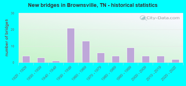
- New bridges - historical statistics
- 41920-1929
- 31930-1939
- 11940-1949
- 211950-1959
- 131960-1969
- 61970-1979
- 41980-1989
- 91990-1999
- 42000-2009
- 42010-2019
- 22020-2022
FCC Registered Cell Phone Towers:
3 (See the full list of FCC Registered Cell Phone Towers in Brownsville)FCC Registered Antenna Towers:
176 (See the full list of FCC Registered Antenna Towers)FCC Registered Commercial Land Mobile Towers:
1 (See the full list of FCC Registered Commercial Land Mobile Towers in Brownsville, TN)FCC Registered Private Land Mobile Towers:
5 (See the full list of FCC Registered Private Land Mobile Towers)FCC Registered Broadcast Land Mobile Towers:
24 (See the full list of FCC Registered Broadcast Land Mobile Towers)FCC Registered Microwave Towers:
15 (See the full list of FCC Registered Microwave Towers in this town)FCC Registered Paging Towers:
5 (See the full list of FCC Registered Paging Towers)FCC Registered Amateur Radio Licenses:
40 (See the full list of FCC Registered Amateur Radio Licenses in Brownsville)FAA Registered Aircraft:
7- Aircraft: SMITH AEROSTAR 601P (Category: Land, Engines: 2, Seats: 6, Weight: Up to 12,499 Pounds, Speed: 144 mph), Engine: LYCOMING TI0-540 SER (310 HP) (Reciprocating)
N-Number: 221CA, N221CA, N-221CA, Serial Number: 61P-0392-133, Year manufactured: 1977, Airworthiness Date: 02/21/1977, Certificate Issue Date: 05/04/2007
Registrant (Co-Owned): Charles A Jr Tripp, 420 W Main St, Brownsville, TN 38012, Other Owners: Judy S Tripp - Aircraft: CESSNA 150G (Category: Land, Seats: 2, Weight: Up to 12,499 Pounds, Speed: 90 mph), Engine: CONT MOTOR 0-200 SERIES (100 HP) (4 Cycle)
N-Number: 3847J, N3847J, N-3847J, Serial Number: 15065147, Year manufactured: 1966, Airworthiness Date: 09/23/1966, Certificate Issue Date: 09/04/2012
Registrant (Individual): James C Escue, 1106 W Main St, Brownsville, TN 38012 - Aircraft: PIPER PA-28-180 (Category: Land, Seats: 4, Weight: Up to 12,499 Pounds, Speed: 107 mph), Engine: LYCOMING O&VO-360 SER (180 HP) (Reciprocating)
N-Number: 4276T, N4276T, N-4276T, Serial Number: 28-7205128, Year manufactured: 1972, Airworthiness Date: 01/06/1972, Certificate Issue Date: 02/20/2014
Registrant (Co-Owned): James R Tippett, 693 Cox Ln, Brownsville, TN 38012, Other Owners: James C Escue - Aircraft: E M F SERVICES INC DR 109 (Category: Land, Seats: 2, Weight: Up to 12,499 Pounds), Engine: LYCOMING AEIO540-L1B5D (300 HP) (Reciprocating)
N-Number: 527MF, N527MF, N-527MF, Serial Number: 527, Year manufactured: 2011, Airworthiness Date: 12/01/2011, Certificate Issue Date: 11/29/2005
Registrant (Corporation): E M F Services Inc, 5455 Tibbs Rd, Brownsville, TN 38012 - Aircraft: PIPER J5A (Category: Land, Seats: 3, Weight: Up to 12,499 Pounds, Speed: 77 mph), Engine: CONT MOTOR A&C75 SERIES (75 HP) (Reciprocating)
N-Number: 35045, N35045, N-35045, Serial Number: 5557, Year manufactured: 1941
Registrant (Individual): Wilson Jr Livingston, Rt 4, Brownsville, TN 38012
Deregistered: Cancel Date: 11/29/2019 - Aircraft: BRITISH AEROSPACE HS 125-700A (Category: Land, Engines: 2, Seats: 15, Weight: 20,000+ Pounds), Engine: GARRETT TFE731 SERIES (3500 Pounds of Thrust) (Turbo-fan)
N-Number: 500FM, N500FM, N-500FM, Serial Number: NA0280, Year manufactured: 1980, Airworthiness Date: 07/17/1998, Certificate Issue Date: 11/01/2013
Registrant (LLC): Blurton Group LLC, Po Box 545, Brownsville, TN 38012
Deregistered: Cancel Date: 06/14/1999 - Aircraft: FAIRCHILD M-62A (Category: Land, Seats: 2, Weight: Up to 12,499 Pounds, Speed: 97 mph), Engine: CONT MOTOR W670 SERIES (250 HP) (Reciprocating)
N-Number: 64705, N64705, N-64705, Serial Number: 176SL
Registrant (Individual): Roy L Hazlerig, 404 Grand Ave, Brownsville, TN 38012
Deregistered: Cancel Date: 04/05/2018
2002 - 2018 National Fire Incident Reporting System (NFIRS) incidents
- Fire incident types reported to NFIRS in Brownsville, TN
- 1,06444.7%Outside Fires
- 58724.7%Structure Fires
- 53922.7%Mobile Property/Vehicle Fires
- 1897.9%Other
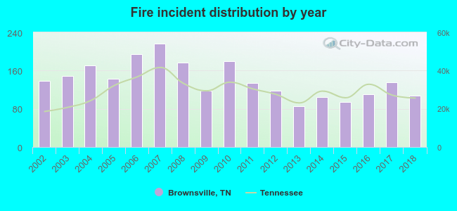 Based on the data from the years 2002 - 2018 the average number of fires per year is 140. The highest number of fire incidents - 216 took place in 2007, and the least - 86 in 2013. The data has a dropping trend.
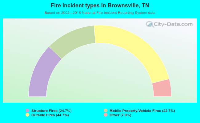 When looking into fire subcategories, the most incidents belonged to: Outside Fires (44.7%), and Structure Fires (24.7%).
Fire-safe hotels and motels in Brownsville, Tennessee:
- Econo Lodge, 2600 Anderson Ave, Brownsville, Tennessee 38012 , Phone: (731) 772-4082, Fax: (731) 772-4084
- Days Inn, 2530 Anderson Ave, Brownsville, Tennessee 38012 , Phone: (731) 772-3297
- Americas Best Value Inn, 110 Sunnny Hill Cv, Brownsville, Tennessee 38012 , Phone: (731) 779-2389, Fax: (731) 772-2064
| Most common first names in Brownsville, TN among deceased individuals | ||
| Name | Count | Lived (average) |
|---|---|---|
| James | 181 | 71.5 years |
| Mary | 154 | 80.7 years |
| William | 138 | 74.6 years |
| John | 126 | 73.7 years |
| Willie | 111 | 73.9 years |
| Robert | 97 | 73.4 years |
| George | 55 | 73.0 years |
| Thomas | 49 | 74.1 years |
| Charlie | 47 | 72.0 years |
| Annie | 44 | 80.4 years |
| Most common last names in Brownsville, TN among deceased individuals | ||
| Last name | Count | Lived (average) |
|---|---|---|
| Taylor | 175 | 74.8 years |
| Bond | 91 | 77.2 years |
| Jones | 83 | 71.3 years |
| Smith | 69 | 76.2 years |
| Mann | 65 | 77.0 years |
| Williams | 54 | 78.3 years |
| Currie | 52 | 76.5 years |
| Davis | 52 | 74.5 years |
| Johnson | 47 | 72.8 years |
| White | 47 | 76.2 years |
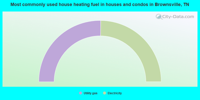
- 50.4%Utility gas
- 49.6%Electricity
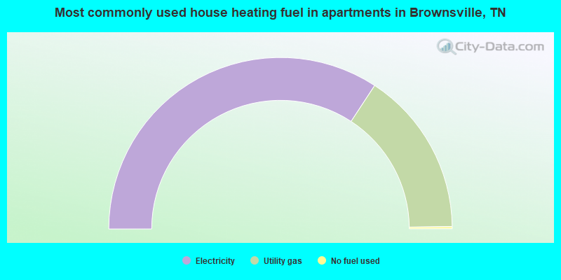
- 68.5%Electricity
- 31.1%Utility gas
- 0.4%No fuel used
Brownsville compared to Tennessee state average:
- Median household income below state average.
- Median house value below state average.
- Unemployed percentage below state average.
- Black race population percentage significantly above state average.
- Foreign-born population percentage below state average.
- Renting percentage above state average.
- Length of stay since moving in significantly above state average.
- Percentage of population with a bachelor's degree or higher significantly below state average.
Brownsville on our top lists:
- #44 on the list of "Top 101 cities with the most people driving a car to work alone (population 5,000+)"
- #53 on the list of "Top 101 cities with largest percentage of females in occupations: production occupations (population 5,000+)"
- #67 on the list of "Top 101 cities with largest percentage of females in industries: manufacturing (population 5,000+)"
- #94 on the list of "Top 100 cities with the largest percentage of females (pop. 5,000+)"
- #96 on the list of "Top 101 cities with the highest number of assaults per 100,000 residents, excludes tourist destinations and others with a lot of outsiders visiting based on city industries data (population 5,000+)"

|
Total of 8 patent applications in 2008-2024.