Bryants, Kentucky
Submit your own pictures of this place and show them to the world
- OSM Map
- General Map
- Google Map
- MSN Map

| Males: 477 | |
| Females: 464 |
| Median resident age: | 36.9 years |
| Kentucky median age: | 35.9 years |
Zip code: 40906
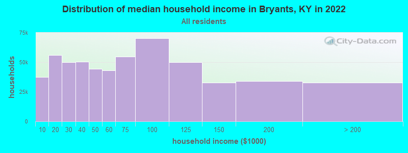
| Bryants: | $37,951 |
| KY: | $59,341 |
Estimated per capita income in 2022: $18,408 (it was $9,369 in 2000)
Bryants CCD income, earnings, and wages data
Estimated median house or condo value in 2022: $97,999 (it was $35,200 in 2000)
| Bryants: | $97,999 |
| KY: | $196,300 |
Detailed information about poverty and poor residents in Bryants, KY


- 92199.1%White alone
- 40.4%Two or more races
- 20.2%Black alone
- 10.1%American Indian alone
- 10.1%Native Hawaiian and Other
Pacific Islander alone
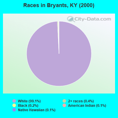
Races in Bryants detailed stats: ancestries, foreign born residents, place of birth
 Recent articles from our blog. Our writers, many of them Ph.D. graduates or candidates, create easy-to-read articles on a wide variety of topics.
Current Local Time: EST time zone
Land area: 41.8 square miles.
Population density: 23 people per square mile (very low).

| Bryants CCD: | 0.8% ($287) |
| Kentucky: | 0.8% ($610) |
Nearest city with pop. 50,000+: Knoxville, TN  (54.8 miles , pop. 173,890).
Nearest city with pop. 200,000+: Fayette, KY (92.9 miles , pop. 260,512).
Nearest city with pop. 1,000,000+: Chicago, IL (404.4 miles , pop. 2,896,016).
Nearest cities:
), ), ), ), ), ), )Latitude: 36.77 N, Longitude: 83.92 W
Area code commonly used in this area: 606

| Here: | 5.4% |
| Kentucky: | 3.8% |
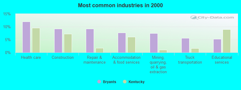
- Health care (12.0%)
- Construction (9.2%)
- Repair & maintenance (9.2%)
- Accommodation & food services (7.7%)
- Mining, quarrying, oil & gas extraction (7.4%)
- Truck transportation (5.5%)
- Educational services (5.2%)
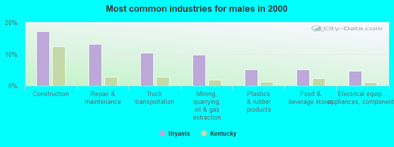
- Construction (17.2%)
- Repair & maintenance (13.2%)
- Truck transportation (10.3%)
- Mining, quarrying, oil & gas extraction (9.8%)
- Plastics & rubber products (5.2%)
- Food & beverage stores (5.2%)
- Electrical equipment, appliances, components (4.6%)
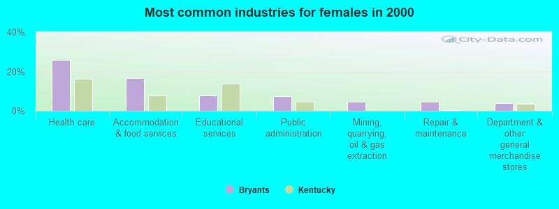
- Health care (25.8%)
- Accommodation & food services (16.6%)
- Educational services (7.9%)
- Public administration (7.3%)
- Mining, quarrying, oil & gas extraction (4.6%)
- Repair & maintenance (4.6%)
- Department & other general merchandise stores (4.0%)
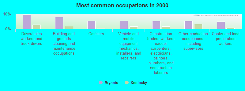
- Driver/sales workers and truck drivers (9.5%)
- Building and grounds cleaning and maintenance occupations (8.0%)
- Cashiers (5.5%)
- Vehicle and mobile equipment mechanics, installers, and repairers (5.5%)
- Construction traders workers except carpenters, electricians, painters, plumbers, and construction laborers (5.2%)
- Other production occupations, including supervisors (5.2%)
- Cooks and food preparation workers (4.9%)
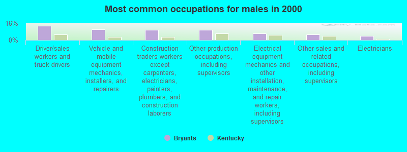
- Driver/sales workers and truck drivers (13.8%)
- Vehicle and mobile equipment mechanics, installers, and repairers (10.3%)
- Construction traders workers except carpenters, electricians, painters, plumbers, and construction laborers (9.8%)
- Other production occupations, including supervisors (9.8%)
- Electrical equipment mechanics and other installation, maintenance, and repair workers, including supervisors (6.3%)
- Other sales and related occupations, including supervisors (5.2%)
- Electricians (4.0%)
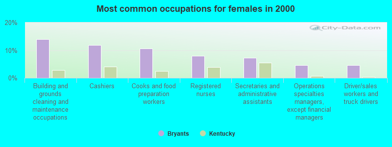
- Building and grounds cleaning and maintenance occupations (13.9%)
- Cashiers (11.9%)
- Cooks and food preparation workers (10.6%)
- Registered nurses (7.9%)
- Secretaries and administrative assistants (7.3%)
- Operations specialties managers, except financial managers (4.6%)
- Driver/sales workers and truck drivers (4.6%)
Average climate in Bryants, Kentucky
Based on data reported by over 4,000 weather stations


(lower is better)
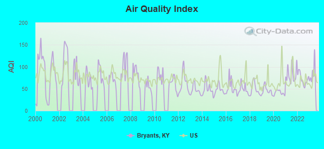
Air Quality Index (AQI) level in 2023 was 80.8. This is about average.
| City: | 80.8 |
| U.S.: | 72.6 |
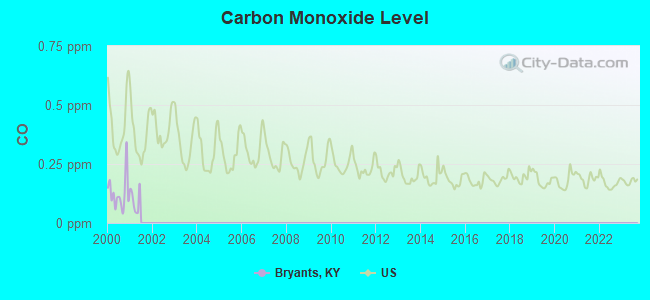
Carbon Monoxide (CO) [ppm] level in 2000 was 0.127. This is significantly better than average. Closest monitor was 15.0 miles away from the city center.
| City: | 0.127 |
| U.S.: | 0.251 |
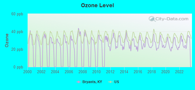
Ozone [ppb] level in 2023 was 31.1. This is about average. Closest monitor was 15.0 miles away from the city center.
| City: | 31.1 |
| U.S.: | 33.3 |
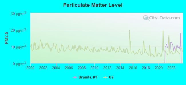
Particulate Matter (PM2.5) [µg/m3] level in 2022 was 9.68. This is about average. Closest monitor was 15.0 miles away from the city center.
| City: | 9.68 |
| U.S.: | 8.11 |
Tornado activity:
Bryants-area historical tornado activity is below Kentucky state average. It is 29% smaller than the overall U.S. average.
On 4/3/1974, a category F4 (max. wind speeds 207-260 mph) tornado 33.7 miles away from the Bryants place center .
On 3/12/1967, a category F3 (max. wind speeds 158-206 mph) tornado 12.8 miles away from the place center .
Earthquake activity:
Bryants-area historical earthquake activity is significantly above Kentucky state average. It is 71% greater than the overall U.S. average.On 7/27/1980 at 18:52:21, a magnitude 5.2 (5.1 MB, 4.7 MS, 5.0 UK, 5.2 UK, Class: Moderate, Intensity: VI - VII) earthquake occurred 99.6 miles away from Bryants center
On 11/30/1973 at 07:48:41, a magnitude 4.7 (4.7 MB, 4.6 ML, Class: Light, Intensity: IV - V) earthquake occurred 66.9 miles away from the city center
On 8/9/2020 at 12:07:37, a magnitude 5.1 (5.1 MW, Depth: 4.7 mi) earthquake occurred 158.3 miles away from Bryants center
On 4/18/2008 at 09:36:59, a magnitude 5.4 (5.1 MB, 4.8 MS, 5.4 MW, 5.2 MW) earthquake occurred 246.5 miles away from the city center
On 9/7/1988 at 02:28:09, a magnitude 4.6 (4.5 MB, 4.6 LG) earthquake occurred 95.3 miles away from the city center
On 8/23/2011 at 17:51:04, a magnitude 5.8 (5.8 MW, Depth: 3.7 mi) earthquake occurred 338.5 miles away from the city center
Magnitude types: regional Lg-wave magnitude (LG), body-wave magnitude (MB), local magnitude (ML), surface-wave magnitude (MS), moment magnitude (MW)
Natural disasters:
The number of natural disasters in Knox County (31) is a lot greater than the US average (15).Major Disasters (Presidential) Declared: 24
Emergencies Declared: 2
Causes of natural disasters: Floods: 22, Storms: 19, Mudslides: 8, Tornadoes: 7, Landslides: 6, Winter Storms: 5, Fires: 2, Snows: 2, Snowstorms: 2, Winds: 2, Blizzard: 1, Freeze: 1, Hurricane: 1, Snowfall: 1, Other: 1 (Note: some incidents may be assigned to more than one category).
Hospitals and medical centers near Bryants:
- BARBOURVILLE HEALTH AND REHABILITATION CENTER (Nursing Home, about 8 miles away; BARBOURVILLE, KY)
- PINEVILLE COMMUNITY HOSPITAL Acute Care Hospitals (about 12 miles away; PINEVILLE, KY)
- MIDDLESBORO HEALTH CARE FACILITY (Nursing Home, about 15 miles away; MIDDLESBORO, KY)
- MIDDLESBORO APPALACHIAN REGIONAL HEALTHCARE HOSPIT Acute Care Hospitals (about 16 miles away; MIDDLESBORO, KY)
- CORBIN HEALTH AND REHABILITATION CENTER (Nursing Home, about 16 miles away; CORBIN, KY)
- THE HERITAGE (Nursing Home, about 16 miles away; CORBIN, KY)
- MIDDLESBORO ARH HOME HEALTH AGENCY (Home Health Center, about 16 miles away; MIDDLESBORO, KY)
Colleges/universities with over 2000 students nearest to Bryants:
- University of the Cumberlands (about 14 miles; Williamsburg, KY; Full-time enrollment: 3,585)
- Lincoln Memorial University (about 20 miles; Harrogate, TN; FT enrollment: 3,706)
- Somerset Community College (about 44 miles; Somerset, KY; FT enrollment: 4,698)
- Hazard Community and Technical College (about 53 miles; Hazard, KY; FT enrollment: 2,087)
- Walters State Community College (about 53 miles; Morristown, TN; FT enrollment: 4,359)
- Southeast Kentucky Community and Technical College (about 54 miles; Cumberland, KY; FT enrollment: 2,196)
- The University of Tennessee-Knoxville (about 57 miles; Knoxville, TN; FT enrollment: 25,483)
Points of interest:
Notable locations in Bryants: Bryants Store (A), Kingtown (B), Little Poplar Creek Fire Department (C). Display/hide their locations on the map
Churches in Bryants include: Clate Church (A), Little Poplar Creek Church (B), New Hope Church (C), Old Poplar Creek Church (D), Prichard Church (E). Display/hide their locations on the map
Cemeteries: Mays Cemetery (1), Prichard Cemetery (2), Mackey Cemetery (3), Browns Cemetery (4), Bryant Cemetery (5), West Cemetery (6), Killian Cemetery (7). Display/hide their locations on the map
Lake: Swan Pond (A). Display/hide its location on the map
Streams, rivers, and creeks: Bain Branch (A), Bennett Branch (B), Catron Branch (C), Sugartree Branch (D), Stony Fork (E), Little Poplar Creek (F), Lewellen Branch (G), Powers Branch (H), Prichard Branch (I). Display/hide their locations on the map
| This place: | 2.4 people |
| Kentucky: | 2.5 people |
| This place: | 59.7% |
| Whole state: | 69.8% |
| This place: | 4.4% |
| Whole state: | 4.5% |
No gay or lesbian households reported
| This place: | 32.6% |
| Whole state: | 15.8% |
| This place: | 7.8% |
| Whole state: | 6.6% |
For population 15 years and over in Bryants:
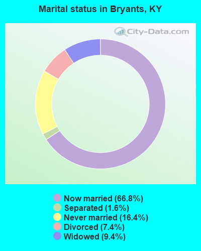
- Never married: 16.4%
- Now married: 66.8%
- Separated: 1.6%
- Widowed: 9.4%
- Divorced: 7.4%
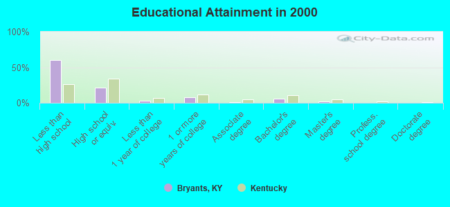
For population 25 years and over in Bryants:
- High school or higher: 40.0%
- Bachelor's degree or higher: 7.8%
- Graduate or professional degree: 1.9%
- Unemployed: 13.1%
- Mean travel time to work (commute): 31.0 minutes
| Here: | 17.6 |
| Kentucky average: | 13.8 |
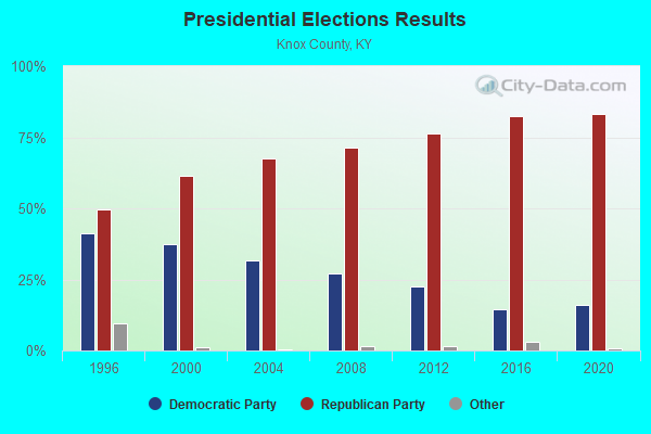
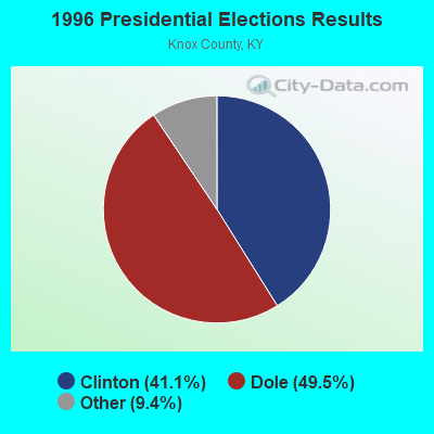
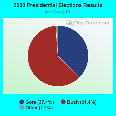
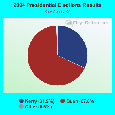
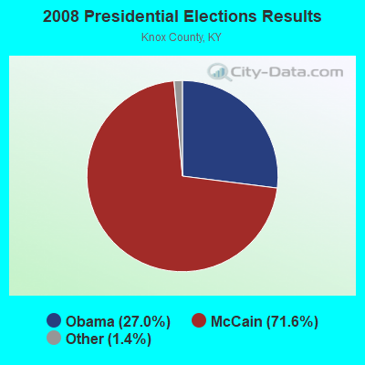
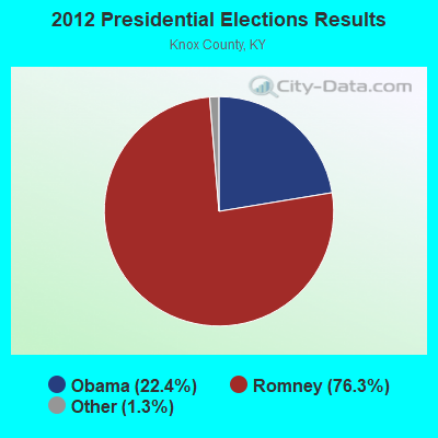
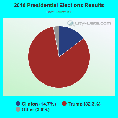
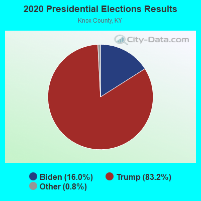
Graphs represent county-level data. Detailed 2008 Election Results
Religion statistics for Bryants, KY (based on Knox County data)
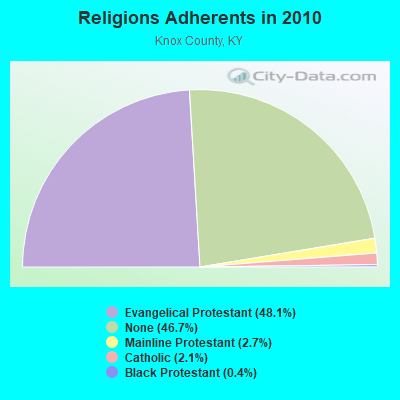
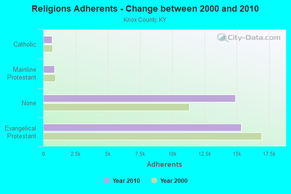
| Religion | Adherents | Congregations |
|---|---|---|
| Evangelical Protestant | 15,334 | 56 |
| Mainline Protestant | 859 | 5 |
| Catholic | 678 | 2 |
| Black Protestant | 123 | 1 |
| Other | - | 1 |
| None | 14,889 | - |
Food Environment Statistics:
| Knox County: | 2.77 / 10,000 pop. |
| Kentucky: | 2.19 / 10,000 pop. |
| Knox County: | 0.31 / 10,000 pop. |
| Kentucky: | 0.74 / 10,000 pop. |
| Knox County: | 3.38 / 10,000 pop. |
| Kentucky: | 4.36 / 10,000 pop. |
| Knox County: | 3.38 / 10,000 pop. |
| State: | 5.74 / 10,000 pop. |
| Knox County: | 11.6% |
| Kentucky: | 11.0% |
| Knox County: | 32.3% |
| Kentucky: | 30.0% |
| Here: | 21.0% |
| State: | 15.9% |
Strongest AM radio stations in Bryants:
- WEKC (710 AM; daytime; 4 kW; WILLIAMSBURG, KY; Owner: GERALD PARKS)
- WYWY (950 AM; 1 kW; BARBOURVILLE, KY; Owner: BARBOURVILLE-COMMNITY BROADC/G CO IN)
- WKVL (850 AM; daytime; 50 kW; KNOXVILLE, TN; Owner: HORNE RADIO, LLC)
- WMIK (560 AM; 2 kW; MIDDLESBORO, KY; Owner: GATEWAY BROADCASTING, INC.)
- WKDP (1330 AM; 5 kW; CORBIN, KY; Owner: EUBANKS BROADCASTING, INC.)
- WEZJ (1440 AM; 2 kW; WILLIAMSBURG, KY; Owner: WHITLEY BROADCASTING CO., INC.)
- WCTT (680 AM; 1 kW; CORBIN, KY; Owner: ENCORE COMMUNICATIONS, INC)
- WANO (1230 AM; 1 kW; PINEVILLE, KY; Owner: CUMBERLAND MEDIA GROUP, INC.)
- WKLB (1290 AM; 5 kW; MANCHESTER, KY; Owner: BARKER BROADCASTING COMPANY, INC.)
- WFSR (970 AM; 5 kW; HARLAN, KY; Owner: EASTERN BROADCASTING COMPAY)
- WHLN (1410 AM; 5 kW; HARLAN, KY)
- WNOX (990 AM; 10 kW; KNOXVILLE, TN)
- WQBB (1040 AM; daytime; 10 kW; POWELL, TN; Owner: JOURNAL BROADCAST CORPORATION)
Strongest FM radio stations in Bryants:
- WMIK-FM (92.7 FM; MIDDLESBORO, KY; Owner: GATEWAY BROADCASTING, INC.)
- WRIL (106.3 FM; PINEVILLE, KY; Owner: PINE HILLS BROADCASTING, INC.)
- WKKQ (96.1 FM; BARBOURVILLE, KY; Owner: BARBOURVILLE COMMUNITY B/NG CO.INC.)
- WEKX (102.7 FM; JELLICO, TN; Owner: WHITLEY BROADCASTING CO., INC.)
- WKDP-FM (99.5 FM; CORBIN, KY; Owner: EUBANKS BROADCASTING, INC.)
- WEZJ-FM (104.3 FM; WILLIAMSBURG, KY; Owner: WHITLEY BROADCASTING CO., INC.)
- WCTT-FM (107.3 FM; CORBIN, KY; Owner: ENCORE COMMUNICATIONS, INC.)
- WDVX (89.9 FM; CLINTON, TN; Owner: CUMBERLAND COMMUNITIES COMMUNI CORP.)
- WCTU (105.9 FM; TAZEWELL, TN; Owner: STAIR COMPANY, INC)
- WIMZ-FM (103.5 FM; KNOXVILLE, TN; Owner: SOUTH CENTRAL COMM., CORP.)
- WOKI-FM (100.3 FM; OAK RIDGE, TN; Owner: OAK RIDGE FM, INC.)
- WSEH (102.7 FM; CUMBERLAND, KY; Owner: CUMBERLAND CITY BROADCASTING, INC.)
- WTUK (105.1 FM; HARLAN, KY; Owner: EASTERN BROADCASTING COMPANY)
- WWLT (103.1 FM; MANCHESTER, KY; Owner: VERNON R. BALDWIN, INC.)
- WAXM (93.5 FM; BIG STONE GAP, VA; Owner: VALLEY BROADCASTING, INC.)
- WYGE (92.3 FM; LONDON, KY; Owner: ETHEL HUFF BROADCASTING, LLC)
- WUOT (91.9 FM; KNOXVILLE, TN; Owner: UNIVERSITY OF TENNESSEE)
- WVCT (91.5 FM; KEAVY, KY; Owner: VICTORY TRAINING SCHOOL CORP.)
- WSGS (101.1 FM; HAZARD, KY; Owner: MOUNTAIN BROADCASTING SERVICE, INC.)
- WJDT (106.5 FM; ROGERSVILLE, TN; Owner: C & S BROADCASTING)
TV broadcast stations around Bryants:
- WKOP-TV (Channel 15; KNOXVILLE, TN; Owner: EAST TENNESSEE PUBLIC COMMUNICATIONS CORP.)
- WVLT-TV (Channel 8; KNOXVILLE, TN; Owner: WVLT LICENSEE CORP.)
- WBIR-TV (Channel 10; KNOXVILLE, TN; Owner: GANNETT PACIFIC CORPORATION)
- WATE-TV (Channel 6; KNOXVILLE, TN; Owner: WATE, G.P.)
- WVTN-LP (Channel 48; CORBIN, KY; Owner: VICTORY TRAINING SCHOOL CORP.)
- W33BK (Channel 33; CORBIN, KY; Owner: TRINITY BROADCASTING NETWORK)
- WAGV (Channel 44; HARLAN, KY; Owner: LIVING FAITH MINISTRIES, INC.)
- W39CK (Channel 20; CORBIN, KY; Owner: DEREK RAY EUBANKS)
- W07AH (Channel 7; BARBOURVILLE, KY; Owner: BARBOURVILLE AREA TELEVISION CORP.)
- W04AF (Channel 4; BARBOURVILLE, KY; Owner: BARBOURVILLE AREA TELEVISION CORP.)
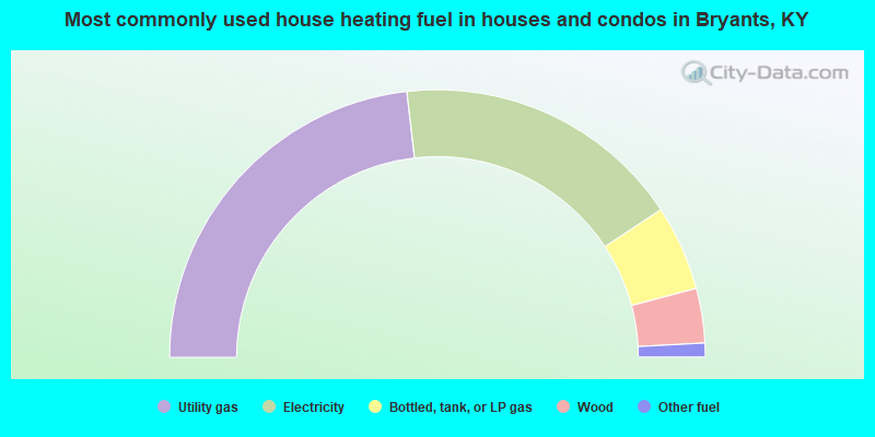
- 46.4%Utility gas
- 35.1%Electricity
- 10.3%Bottled, tank, or LP gas
- 6.6%Wood
- 1.7%Other fuel
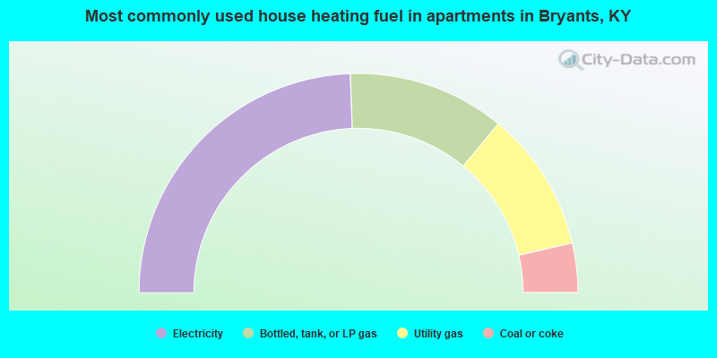
- 48.8%Electricity
- 23.2%Bottled, tank, or LP gas
- 20.7%Utility gas
- 7.3%Coal or coke
Bryants compared to Kentucky state average:
- Median household income below state average.
- Median house value below state average.
- Black race population percentage significantly below state average.
- Hispanic race population percentage significantly below state average.
- Median age below state average.
- Foreign-born population percentage significantly below state average.
- Renting percentage significantly below state average.
- Length of stay since moving in significantly above state average.
- Number of rooms per house significantly below state average.
- House age significantly below state average.
- Number of college students significantly below state average.
- Percentage of population with a bachelor's degree or higher significantly below state average.