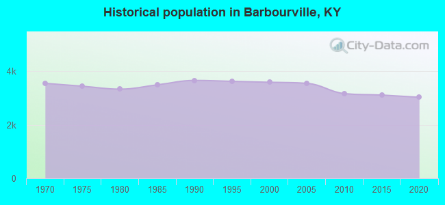
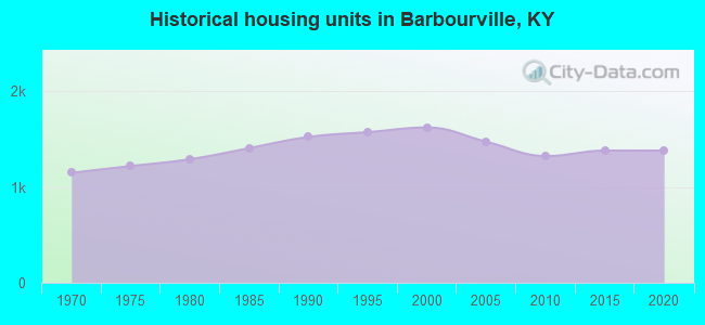
Barbourville, Kentucky
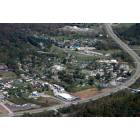
Barbourville: barbourville,ky.
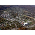
Barbourville: barbourville kentucky
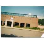
Barbourville: POST OFFICE
- add
your
Submit your own pictures of this city and show them to the world
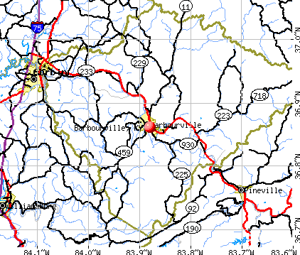
- OSM Map
- General Map
- Google Map
- MSN Map
Population change since 2000: -12.0%
 |
| Males: 1,138 | |
| Females: 2,019 |
| Median resident age: | 41.1 years |
| Kentucky median age: | 39.4 years |
| Barbourville: | $20,989 |
| KY: | $59,341 |
Estimated per capita income in 2022: $27,787 (it was $11,485 in 2000)
Barbourville city income, earnings, and wages data
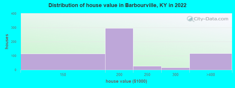
Estimated median house or condo value in 2022: $181,217 (it was $69,400 in 2000)
| Barbourville: | $181,217 |
| KY: | $196,300 |
Mean prices in 2022: all housing units: $196,009; detached houses: $194,199
Median gross rent in 2022: $740.
(40.7% for White Non-Hispanic residents, 100.0% for Hispanic or Latino residents, 100.0% for two or more races residents)
Detailed information about poverty and poor residents in Barbourville, KY
Compare current foreclosures near Barbourville, KY:
| Photo | Address | Area | Beds / Baths | Price | Details |
|---|---|---|---|---|---|

|
#1
Ky 3440
Barbourville, KY 40906
|
- sq. feet
|
1 baths 3 beds |
show details | |

|
#2
Edgewood Dr
Barbourville, KY 40906
|
2,104 sq. feet
|
3 baths 4 beds |
show details | |

|
#3
Kay Jay Camp Rd
Barbourville, KY 40906
|
700 sq. feet
|
1 baths 2 beds |
show details | |

|
#4
Catron Ave
Barbourville, KY 40906
|
- sq. feet
|
- baths - beds |
show details | |

|
#5
Ky 6
Barbourville, KY 40906
|
- sq. feet
|
- baths - beds |
show details | |

|
#6
Sampson Ln
Barbourville, KY 40906
|
- sq. feet
|
- baths - beds |
show details | |

|
#7
Bull Run Rd
Barbourville, KY 40906
|
- sq. feet
|
- baths - beds |
show details | |

|
#8
Cumberland Ave Apt 1c
Barbourville, KY 40906
|
- sq. feet
|
- baths - beds |
show details | |

|
#9
N Us Highway 25e
Barbourville, KY 40906
|
- sq. feet
|
- baths - beds |
show details | |

|
#10
Cumberland Ave Apt 2b
Barbourville, KY 40906
|
- sq. feet
|
- baths - beds |
show details |
| Photo | Address | Area | Beds / Baths | Price | Details |
|---|---|---|---|---|---|

|
#11
Ky 459
Barbourville, KY 40906
|
- sq. feet
|
- baths - beds |
show details | |

|
#12
Gregory Himes Ln
Barbourville, KY 40906
|
- sq. feet
|
- baths - beds |
show details | |

|
#13
The Meadow Trl
Barbourville, KY 40906
|
- sq. feet
|
- baths - beds |
show details | |

|
#14
Cactus Ln
Barbourville, KY 40906
|
- sq. feet
|
- baths - beds |
show details | |

|
#15
Browns Creek Rd
Williamsburg, KY 40769
|
1,200 sq. feet
|
1 baths 3 beds |
$82,500
|
show details |

|
#16
1/2 N Broadway St
Barbourville, KY 40906
|
- sq. feet
|
- baths - beds |
show details | |

|
#17
N Main St
Barbourville, KY 40906
|
- sq. feet
|
- baths - beds |
show details | |

|
#18
Patterson Ln
Barbourville, KY 40906
|
- sq. feet
|
- baths - beds |
show details | |

|
#19
Mitchell Ave
Barbourville, KY 40906
|
- sq. feet
|
- baths - beds |
show details | |

|
#20
Hammons Fork Rd
Barbourville, KY 40906
|
- sq. feet
|
- baths - beds |
show details |
| Photo | Address | Area | Beds / Baths | Price | Details |
|---|---|---|---|---|---|

|
#21
Miracle Mountain Ln
Barbourville, KY 40906
|
- sq. feet
|
- baths - beds |
show details | |

|
#22
Gray Ln
Barbourville, KY 40906
|
- sq. feet
|
- baths - beds |
show details | |

|
#23
John Bailey Rd
Arjay, KY 40902
|
- sq. feet
|
- baths - beds |
$17,900
|
show details |

|
#24
Riverside Loop
Lily, KY 40740
|
1,125 sq. feet
|
2 baths 3 beds |
show details | |

|
#25
Bee Quick Ln
Gray, KY 40734
|
1,408 sq. feet
|
1 baths 3 beds |
show details | |

|
#26
Big Brush Church Creek Rd
Trosper, KY 40995
|
- sq. feet
|
- baths - beds |
$11,900
|
show details |

|
#27
Ky 2417
Corbin, KY 40701
|
1,467 sq. feet
|
1 baths 3 beds |
show details | |

|
#28
Ky 6
Corbin, KY 40701
|
768 sq. feet
|
1 baths 2 beds |
show details | |

|
#29
Riverside Loop
Lily, KY 40740
|
1,120 sq. feet
|
1 baths 3 beds |
show details | |

|
#30
S Ky 1629
Corbin, KY 40701
|
2,150 sq. feet
|
2 baths 3 beds |
show details |
| Photo | Address | Area | Beds / Baths | Price | Details |
|---|---|---|---|---|---|

|
#31
Echo Valley Rd
Lily, KY 40740
|
2,325 sq. feet
|
2 baths 3 beds |
show details | |

|
#32
Lewis St
Corbin, KY 40701
|
1,008 sq. feet
|
1 baths 3 beds |
show details | |

|
#33
Hopkins Cemetery Rd
Lily, KY 40740
|
1,236 sq. feet
|
2 baths 3 beds |
show details | |

|
#34
Mcfadden Cir
Corbin, KY 40701
|
2,100 sq. feet
|
2 baths 3 beds |
show details | |

|
#35
Gordon Hill Pike
Corbin, KY 40701
|
2,304 sq. feet
|
2 baths 3 beds |
show details | |

|
#36
Goodwin St
Corbin, KY 40701
|
1,776 sq. feet
|
1 baths 3 beds |
show details | |

|
#37
17th St
Corbin, KY 40701
|
960 sq. feet
|
1 baths 2 beds |
show details | |

|
#38
Rockhouse Branch Rd
Manchester, KY 40962
|
1,209 sq. feet
|
2 baths 3 beds |
show details | |

|
#39
Corinth Cemetery Rd
Corbin, KY 40701
|
1,596 sq. feet
|
1 baths 3 beds |
show details | |

|
#40
Elisha Feltner Rd
London, KY 40744
|
1,368 sq. feet
|
2 baths 3 beds |
show details |
| Photo | Address | Area | Beds / Baths | Price | Details |
|---|---|---|---|---|---|

|
#41
W Gordon St
Corbin, KY 40701
|
3,519 sq. feet
|
2 baths 4 beds |
show details | |

|
#42
Caldwell St
Corbin, KY 40701
|
- sq. feet
|
2 baths 3 beds |
show details | |

|
#43
Holly Ln
Corbin, KY 40701
|
3,142 sq. feet
|
2 baths 4 beds |
show details | |

|
#44
Kirkwood Dr
London, KY 40744
|
1,904 sq. feet
|
2 baths 3 beds |
show details | |

|
#45
Rons Pond Rd
Corbin, KY 40701
|
2,200 sq. feet
|
2 baths 3 beds |
show details | |

|
#46
Eagles Nest Rd
Corbin, KY 40701
|
1,924 sq. feet
|
2 baths 3 beds |
show details | |

|
#47
Keeneland Trl
Corbin, KY 40701
|
1,408 sq. feet
|
1 baths 3 beds |
show details | |

|
#48
Riva Ridge Trl
Corbin, KY 40701
|
2,424 sq. feet
|
2 baths 3 beds |
show details | |

|
#49
S Highway 11
Manchester, KY 40962
|
1,416 sq. feet
|
1 baths 3 beds |
show details | |

|
Check over 1 million property listings on Foreclosure.com!
|
browse all offers | |||


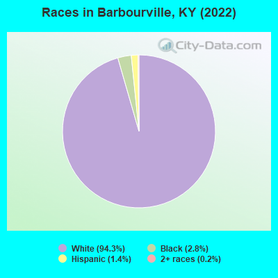
- 3,01894.3%White alone
- 912.8%Black alone
- 461.4%Hispanic
- 80.2%Two or more races
Races in Barbourville detailed stats: ancestries, foreign born residents, place of birth
According to our research of Kentucky and other state lists, there were 23 registered sex offenders living in Barbourville, Kentucky as of April 27, 2024.
The ratio of all residents to sex offenders in Barbourville is 139 to 1.
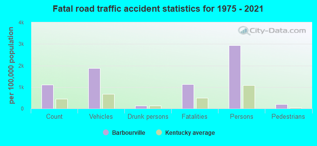
Type |
2009 |
2010 |
2011 |
2012 |
2013 |
2014 |
2015 |
2016 |
2017 |
2018 |
2019 |
2020 |
2021 |
2022 |
|---|---|---|---|---|---|---|---|---|---|---|---|---|---|---|
| Murders (per 100,000) | 0 (0.0) | 0 (0.0) | 0 (0.0) | 0 (0.0) | 0 (0.0) | 0 (0.0) | 1 (31.8) | 0 (0.0) | 0 (0.0) | 0 (0.0) | 0 (0.0) | 0 (0.0) | 0 (0.0) | 0 (0.0) |
| Rapes (per 100,000) | 2 (55.3) | 0 (0.0) | 0 (0.0) | 1 (31.5) | 1 (31.9) | 0 (0.0) | 0 (0.0) | 0 (0.0) | 1 (31.6) | 4 (129.3) | 1 (32.4) | 0 (0.0) | 0 (0.0) | 2 (67.8) |
| Robberies (per 100,000) | 1 (27.7) | 0 (0.0) | 3 (94.1) | 1 (31.5) | 6 (191.1) | 0 (0.0) | 3 (95.3) | 3 (94.5) | 3 (94.7) | 7 (226.2) | 2 (64.7) | 1 (33.1) | 4 (135.4) | 0 (0.0) |
| Assaults (per 100,000) | 1 (27.7) | 0 (0.0) | 2 (62.8) | 2 (62.9) | 1 (31.9) | 2 (63.5) | 2 (63.6) | 3 (94.5) | 5 (157.8) | 10 (323.2) | 6 (194.2) | 5 (165.7) | 6 (203.0) | 1 (33.9) |
| Burglaries (per 100,000) | 4 (110.7) | 15 (473.9) | 12 (376.5) | 11 (346.1) | 11 (350.4) | 14 (444.2) | 12 (381.3) | 14 (441.1) | 24 (757.3) | 14 (452.5) | 33 (1,068) | 17 (563.3) | 18 (609.1) | 14 (474.3) |
| Thefts (per 100,000) | 26 (719.4) | 32 (1,011) | 28 (878.6) | 31 (975.5) | 17 (541.6) | 12 (380.7) | 31 (985.1) | 29 (913.7) | 47 (1,483) | 48 (1,551) | 25 (809.1) | 38 (1,259) | 22 (744.5) | 22 (745.3) |
| Auto thefts (per 100,000) | 5 (138.4) | 3 (94.8) | 4 (125.5) | 3 (94.4) | 2 (63.7) | 3 (95.2) | 2 (63.6) | 10 (315.1) | 19 (599.6) | 23 (743.4) | 9 (291.3) | 12 (397.6) | 13 (439.9) | 5 (169.4) |
| Arson (per 100,000) | 0 (0.0) | 0 (0.0) | 0 (0.0) | 0 (0.0) | 0 (0.0) | 2 (63.5) | 0 (0.0) | 0 (0.0) | 0 (0.0) | 0 (0.0) | 0 (0.0) | 0 (0.0) | 0 (0.0) | 0 (0.0) |
| City-Data.com crime index | 105.7 | 81.2 | 112.3 | 118.0 | 140.5 | 66.6 | 176.0 | 139.9 | 245.5 | 389.1 | 214.6 | 164.7 | 188.8 | 137.5 |
The City-Data.com crime index weighs serious crimes and violent crimes more heavily. Higher means more crime, U.S. average is 246.1. It adjusts for the number of visitors and daily workers commuting into cities.
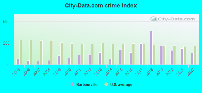
Crime rate in Barbourville detailed stats: murders, rapes, robberies, assaults, burglaries, thefts, arson
Full-time law enforcement employees in 2017, including police officers: 12 (11 officers - 11 male; 0 female).
| Officers per 1,000 residents here: | 3.47 |
| Kentucky average: | 1.88 |
 Recent articles from our blog. Our writers, many of them Ph.D. graduates or candidates, create easy-to-read articles on a wide variety of topics.

 | Can anyone give me a run down on each popular city in KY? The good, bad, and ugly of living in KY? (32 replies) |
| SE Kentucky area (45 replies) |
| Looking at moving from California to Kentucky.... or Maine. (50 replies) |
| Is there organized crime in rural Kentucky ? (46 replies) |
| Most "Authentic" Places to Visit in Eastern KY? (27 replies) |
| Looking to Relocate to Kentucky (14 replies) |
Latest news from Barbourville, KY collected exclusively by city-data.com from local newspapers, TV, and radio stations
Ancestries: Irish (32.9%), English (14.7%), American (7.7%), Eastern European (5.4%), German (4.4%), British (2.4%).
Current Local Time: EST time zone
Incorporated on 03/10/1854
Land area: 3.49 square miles.
Population density: 904 people per square mile (low).
32 residents are foreign born
| This city: | 1.0% |
| Kentucky: | 4.1% |
Median real estate property taxes paid for housing units with mortgages in 2022: $1,722 (0.9%)
Median real estate property taxes paid for housing units with no mortgage in 2022: $1,224 (0.7%)
Nearest city with pop. 50,000+: Knoxville, TN  (61.5 miles , pop. 173,890).
Nearest city with pop. 200,000+: Fayette, KY (87.6 miles , pop. 260,512).
Nearest city with pop. 1,000,000+: Chicago, IL (399.8 miles , pop. 2,896,016).
Nearest cities:
), ), ), ), ), ), Latitude: 36.86 N, Longitude: 83.88 W
Daytime population change due to commuting: +1,638 (+51.2%)
Workers who live and work in this city: 546 (51.0%)
Area code: 606
Barbourville, Kentucky accommodation & food services, waste management - Economy and Business Data
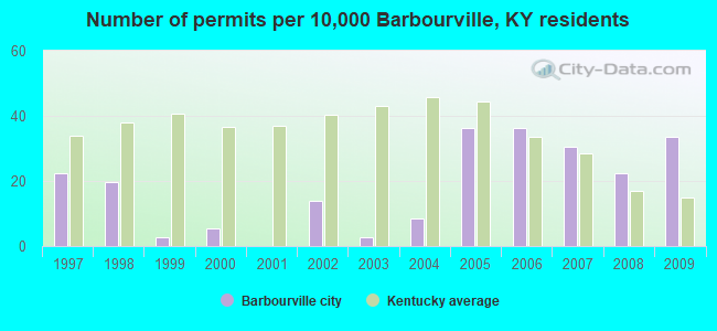
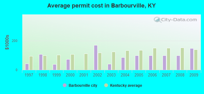
Single-family new house construction building permits:
- 2009: 12 buildings, average cost: $150,000
- 2008: 8 buildings, average cost: $100,400
- 2007: 11 buildings, average cost: $100,400
- 2006: 13 buildings, average cost: $100,400
- 2005: 13 buildings, average cost: $100,400
- 2004: 3 buildings, average cost: $86,700
- 2003: 1 building, cost: $40,000
- 2002: 5 buildings, average cost: $170,500
- 2000: 2 buildings, average cost: $74,000
- 1999: 1 building, cost: $37,500
- 1998: 7 buildings, average cost: $106,600
- 1997: 8 buildings, average cost: $43,400
| Here: | 5.4% |
| Kentucky: | 3.8% |
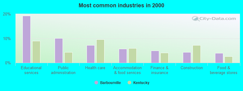
- Educational services (19.2%)
- Public administration (10.1%)
- Health care (7.2%)
- Accommodation & food services (5.7%)
- Finance & insurance (5.0%)
- Construction (4.4%)
- Food & beverage stores (4.0%)
- Educational services (17.7%)
- Construction (9.8%)
- Public administration (7.6%)
- Health care (5.6%)
- Finance & insurance (5.1%)
- Professional, scientific, technical services (4.3%)
- Food & beverage stores (3.6%)
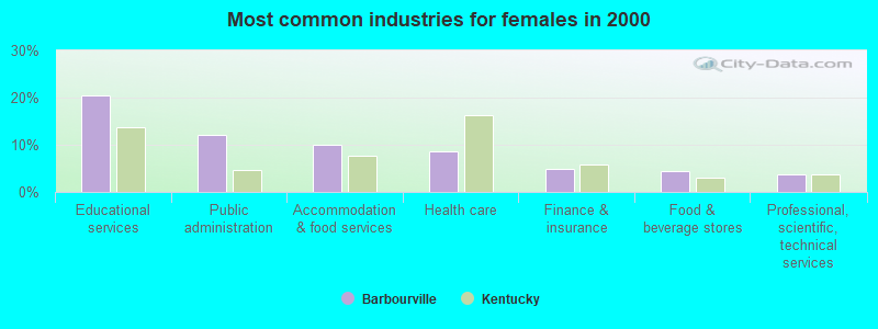
- Educational services (20.4%)
- Public administration (12.1%)
- Accommodation & food services (9.9%)
- Health care (8.5%)
- Finance & insurance (4.9%)
- Food & beverage stores (4.3%)
- Professional, scientific, technical services (3.6%)
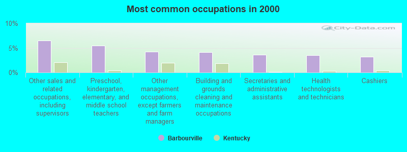
- Other sales and related occupations, including supervisors (6.5%)
- Preschool, kindergarten, elementary, and middle school teachers (5.5%)
- Other management occupations, except farmers and farm managers (4.2%)
- Building and grounds cleaning and maintenance occupations (4.1%)
- Secretaries and administrative assistants (3.6%)
- Health technologists and technicians (3.5%)
- Cashiers (3.2%)
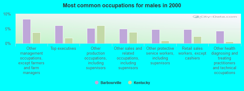
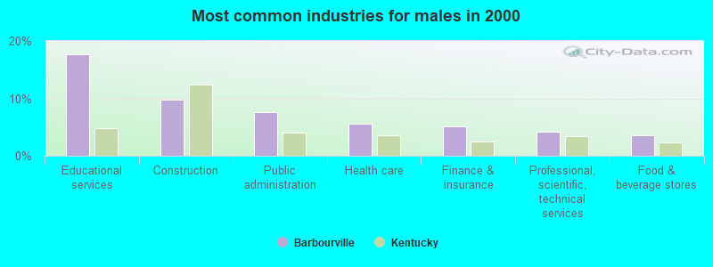
- Other management occupations, except farmers and farm managers (8.3%)
- Top executives (6.0%)
- Other production occupations, including supervisors (5.1%)
- Other sales and related occupations, including supervisors (4.9%)
- Other protective service workers, including supervisors (4.7%)
- Retail sales workers, except cashiers (4.7%)
- Other health diagnosing and treating practitioners and technical occupations (4.3%)

- Preschool, kindergarten, elementary, and middle school teachers (8.1%)
- Other sales and related occupations, including supervisors (7.8%)
- Secretaries and administrative assistants (6.5%)
- Customer service representatives (5.6%)
- Cashiers (5.4%)
- Building and grounds cleaning and maintenance occupations (5.1%)
- Other teachers, instructors, education, training, and library occupations (4.3%)
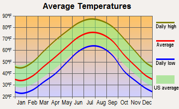
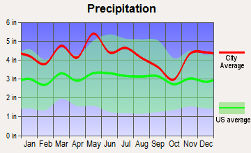
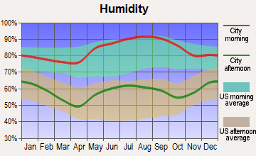
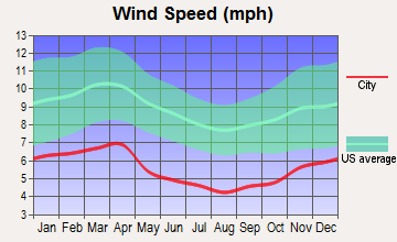
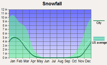
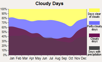
Average climate in Barbourville, Kentucky
Based on data reported by over 4,000 weather stations

|
|

(lower is better)
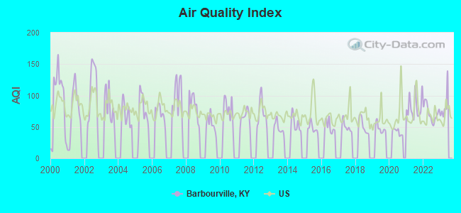
Air Quality Index (AQI) level in 2022 was 72.3. This is about average.
| City: | 72.3 |
| U.S.: | 72.6 |
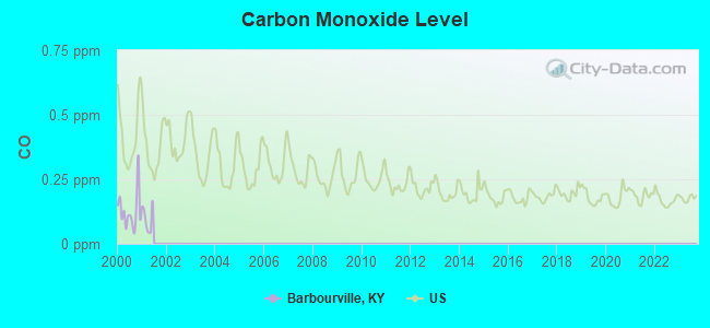
Carbon Monoxide (CO) [ppm] level in 2000 was 0.127. This is significantly better than average. Closest monitor was 19.2 miles away from the city center.
| City: | 0.127 |
| U.S.: | 0.251 |
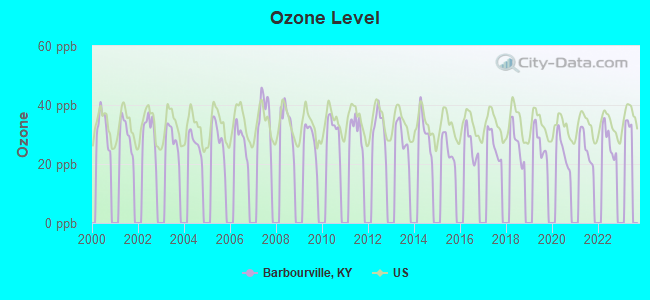
Ozone [ppb] level in 2022 was 27.8. This is about average. Closest monitor was 19.2 miles away from the city center.
| City: | 27.8 |
| U.S.: | 33.3 |
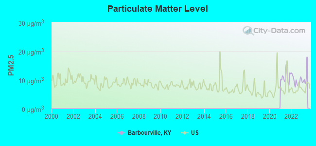
Particulate Matter (PM2.5) [µg/m3] level in 2022 was 9.68. This is about average. Closest monitor was 18.7 miles away from the city center.
| City: | 9.68 |
| U.S.: | 8.11 |
Tornado activity:
Barbourville-area historical tornado activity is below Kentucky state average. It is 30% smaller than the overall U.S. average.
On 4/3/1974, a category F4 (max. wind speeds 207-260 mph) tornado 36.8 miles away from the Barbourville city center .
On 3/12/1967, a category F3 (max. wind speeds 158-206 mph) tornado 18.8 miles away from the city center .
Earthquake activity:
Barbourville-area historical earthquake activity is significantly above Kentucky state average. It is 69% greater than the overall U.S. average.On 7/27/1980 at 18:52:21, a magnitude 5.2 (5.1 MB, 4.7 MS, 5.0 UK, 5.2 UK, Class: Moderate, Intensity: VI - VII) earthquake occurred 93.0 miles away from the city center
On 8/9/2020 at 12:07:37, a magnitude 5.1 (5.1 MW, Depth: 4.7 mi) earthquake occurred 156.8 miles away from Barbourville center
On 11/30/1973 at 07:48:41, a magnitude 4.7 (4.7 MB, 4.6 ML, Class: Light, Intensity: IV - V) earthquake occurred 73.6 miles away from the city center
On 4/18/2008 at 09:36:59, a magnitude 5.4 (5.1 MB, 4.8 MS, 5.4 MW, 5.2 MW) earthquake occurred 245.4 miles away from the city center
On 9/7/1988 at 02:28:09, a magnitude 4.6 (4.5 MB, 4.6 LG) earthquake occurred 88.7 miles away from Barbourville center
On 8/23/2011 at 17:51:04, a magnitude 5.8 (5.8 MW, Depth: 3.7 mi) earthquake occurred 334.5 miles away from the city center
Magnitude types: regional Lg-wave magnitude (LG), body-wave magnitude (MB), local magnitude (ML), surface-wave magnitude (MS), moment magnitude (MW)
Natural disasters:
The number of natural disasters in Knox County (31) is a lot greater than the US average (15).Major Disasters (Presidential) Declared: 24
Emergencies Declared: 2
Causes of natural disasters: Floods: 22, Storms: 19, Mudslides: 8, Tornadoes: 7, Landslides: 6, Winter Storms: 5, Fires: 2, Snows: 2, Snowstorms: 2, Winds: 2, Blizzard: 1, Freeze: 1, Hurricane: 1, Snowfall: 1, Other: 1 (Note: some incidents may be assigned to more than one category).
Hospitals and medical centers in Barbourville:
- KNOX COUNTY HOSPITAL (Government - Local, provides emergency services, 80 HOSPITAL DRIVE)
- BARBOURVILLE HEALTH AND REHABILITATION CENTER (117 SHELBY STREET)
- KNOX COUNTY HOSPITAL (80 HOSPITAL DRIVE)
- RAI - BARBOURVILLE HOME THERAPY CTR. (315 HOSPITAL DR., SUITE 3, KNOX PROFESSIONAL PARK.)
- KNOX COUNTY HEALTH DEPARTMENT HHA (261 HOSPITAL DRIVE)
Heliports located in Barbourville:
College/University in Barbourville:
Colleges/universities with over 2000 students nearest to Barbourville:
- University of the Cumberlands (about 18 miles; Williamsburg, KY; Full-time enrollment: 3,585)
- Lincoln Memorial University (about 23 miles; Harrogate, TN; FT enrollment: 3,706)
- Somerset Community College (about 44 miles; Somerset, KY; FT enrollment: 4,698)
- Hazard Community and Technical College (about 47 miles; Hazard, KY; FT enrollment: 2,087)
- Southeast Kentucky Community and Technical College (about 50 miles; Cumberland, KY; FT enrollment: 2,196)
- Walters State Community College (about 57 miles; Morristown, TN; FT enrollment: 4,359)
- The University of Tennessee-Knoxville (about 63 miles; Knoxville, TN; FT enrollment: 25,483)
Public high schools in Barbourville:
- KNOX CENTRAL HIGH SCHOOL (Students: 920, Location: 100 PANTHER WAY, Grades: 9-12)
- BARBOURVILLE CITY SCHOOL (Students: 633, Location: 140 SCHOOL ST, Grades: PK-12)
- KNOX APPALACHIAN SCHOOL (Location: 1909 KY HWY 3439, Grades: 6-12)
- KNOX COUNTY DAY TREATMENT (Location: 135 WALL ST, Grades: 8-12)
Public elementary/middle schools in Barbourville:
- JESSE D LAY ELEMENTARY SCHOOL (Students: 480, Location: 220 N ALLISON AVE, Grades: PK-6)
- G R HAMPTON ELEMENTARY SCHOOL (Students: 443, Location: 60 KY 3441, Grades: PK-6)
- KNOX COUNTY MIDDLE SCHOOL (Location: 311 N MAIN ST, Grades: 7-8)
- CENTRAL ELEMENTARY SCHOOL (Location: 1000 KY 3439, Grades: PK-6)
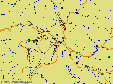
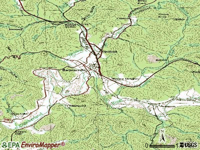
Points of interest:
Notable locations in Barbourville: Barbourville Fire Department Station 2 (A), Barbourville Fire Department Station 1 (B), Knox County Ambulance Service (C). Display/hide their locations on the map
Cemeteries: Barbourville Cemetery (1), Johes Cemetery (2), Adam and Eve Cemetery (3). Display/hide their locations on the map
Streams, rivers, and creeks: Richland Creek (A), Hanson Branch (B), Goodin Branch (C). Display/hide their locations on the map
Hotels: College Motel (429 College Street), Best Western Wilderness Trail (1476 South US 25 East).
Courts: Kentucky State - Judicial Department- Juvenile Justice (700 Pitzer Street), Kentucky State - Judicial Department- Administrative Office Of The Courts- Pret (102 Coles Court), Knox County - Barbourville- Circuit Court Judge (Court House), Knox Co Fiscal Court (40 Back Track Road), Knox County - Barbourville- Circuit Court Clerk (102 Coles Court), Knox CO Juvenile Court Expediter (122 Court Square).
Birthplace of: George Madison Adams - Representative, William A. Stanfill - Politician.
Drinking water stations with addresses in Barbourville and their reported violations in the past:
BARBOURVILLE WATER & ELECTRIC (Population served: 17,892, Surface water):Past health violations:KNOX COUNTY UTILITY COMMISSION (Population served: 7,948, Surface water):Past monitoring violations:
- MCL, Monthly (TCR) - In OCT-2005, Contaminant: Coliform. Follow-up actions: St Public Notif requested (DEC-20-2005), St Formal NOV issued (DEC-20-2005), St Compliance achieved (DEC-20-2005), St Public Notif received (FEB-20-2006)
- MCL, Monthly (TCR) - In JUN-2005, Contaminant: Coliform. Follow-up actions: St Public Notif requested (AUG-19-2005), St Formal NOV issued (AUG-19-2005), St Compliance achieved (AUG-20-2005), St Public Notif received (NOV-04-2005)
- MCL, Monthly (TCR) - In APR-2005, Contaminant: Coliform. Follow-up actions: St Public Notif requested (MAY-26-2005), St Formal NOV issued (MAY-26-2005), St Compliance achieved (JUN-10-2005), St Public Notif received (NOV-04-2005)
- Monitoring and Reporting (DBP) - Between FEB-2014 and APR-2014, Contaminant: TTHM
- Monitoring and Reporting (DBP) - Between FEB-2014 and APR-2014, Contaminant: Total Haloacetic Acids (HAA5)
- Monitoring and Reporting (DBP) - Between NOV-2013 and JAN-2014, Contaminant: TTHM. Follow-up actions: St Formal NOV issued (MAY-01-2014), St Public Notif requested (MAY-01-2014)
- Monitoring and Reporting (DBP) - Between NOV-2013 and JAN-2014, Contaminant: Total Haloacetic Acids (HAA5). Follow-up actions: St Formal NOV issued (MAY-01-2014), St Public Notif requested (MAY-01-2014)
- Monitoring and Reporting (DBP) - In OCT-2013, Contaminant: TTHM. Follow-up actions: St Formal NOV issued (FEB-05-2014), St Public Notif requested (FEB-05-2014)
- One routine major monitoring violation
- 3 minor monitoring violations
- 2 regular monitoring violations
- 2 other older monitoring violations
Past health violations:Past monitoring violations:
- MCL, Monthly (TCR) - In JUL-2013, Contaminant: Coliform. Follow-up actions: St Public Notif requested (SEP-11-2013), St Formal NOV issued (SEP-11-2013), St Compliance achieved (OCT-10-2013), St Public Notif received (OCT-24-2013)
- Monitoring, Repeat Major (TCR) - In SEP-2005, Contaminant: Coliform (TCR). Follow-up actions: St Public Notif requested (NOV-02-2005), St Formal NOV issued (NOV-02-2005), St Public Notif received (DEC-08-2006), St Compliance achieved (MAR-20-2007)
- 21 regular monitoring violations
| This city: | 2.2 people |
| Kentucky: | 2.5 people |
| This city: | 54.7% |
| Whole state: | 66.9% |
| This city: | 4.2% |
| Whole state: | 6.4% |
Likely homosexual households (counted as self-reported same-sex unmarried-partner households)
- Lesbian couples: 0.4% of all households
- Gay men: 0.2% of all households
People in group quarters in Barbourville in 2010:
- 301 people in college/university student housing
- 132 people in nursing facilities/skilled-nursing facilities
- 53 people in local jails and other municipal confinement facilities
People in group quarters in Barbourville in 2000:
- 221 people in college dormitories (includes college quarters off campus)
- 117 people in nursing homes
- 50 people in local jails and other confinement facilities (including police lockups)
- 35 people in wards in general hospitals for patients who have no usual home elsewhere
Banks with branches in Barbourville (2011 data):
- Commercial Bank: Cumberland Parkway Branch, Union Plaza Branch, Auto Bank Branch, Barbourville-North Main Street Branc. Info updated 2008/09/25: Bank assets: $807.9 mil, Deposits: $626.4 mil, headquarters in Harrogate, TN, positive income, Commercial Lending Specialization, 20 total offices, Holding Company: Unified Shares, Llc
- FORCHT BANK, NATIONAL ASSOCIATION: Barbourville - Main at 406 Knox St, branch established on 1990/05/14; Barbourville - Highway Branch at 1881 South Us 25e, branch established on 2011/01/01. Info updated 2008/01/08: Bank assets: $992.1 mil, Deposits: $796.4 mil, headquarters in Lexington, KY, positive income, 34 total offices, Holding Company: Forcht Bancorp, Inc.
- PNC Bank, National Association: Parkway Plaza Branch at Cumberland Gap Pkwy, branch established on 1988/10/20. Info updated 2012/03/20: Bank assets: $263,309.6 mil, Deposits: $197,343.0 mil, headquarters in Wilmington, DE, positive income, Commercial Lending Specialization, 3085 total offices, Holding Company: Pnc Financial Services Group, Inc., The
- Hometown Bank of Corbin, Inc.: Barbourville Branch at 238 Cumberland Avenue, branch established on 2008/10/15. Info updated 2006/05/01: Bank assets: $128.1 mil, Deposits: $105.8 mil, headquarters in Corbin, KY, positive income, Commercial Lending Specialization, 5 total offices, Holding Company: Hometown Bancshares, Inc.
For population 15 years and over in Barbourville:
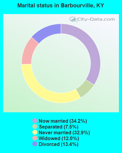
- Never married: 32.9%
- Now married: 34.2%
- Separated: 7.5%
- Widowed: 12.0%
- Divorced: 13.4%
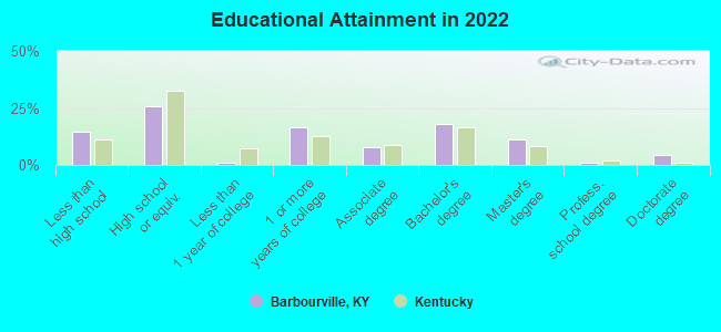
For population 25 years and over in Barbourville:
- High school or higher: 84.8%
- Bachelor's degree or higher: 32.8%
- Graduate or professional degree: 16.0%
- Unemployed: 14.4%
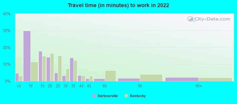
- Mean travel time to work (commute): 16.7 minutes
| Here: | 11.5 |
| Kentucky average: | 11.7 |
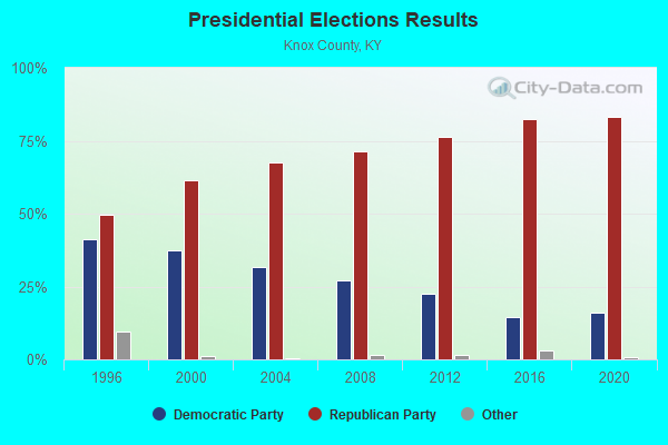
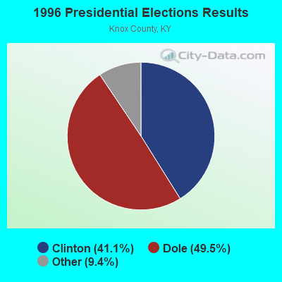
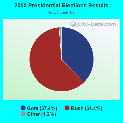
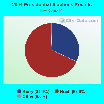
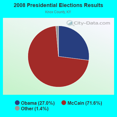
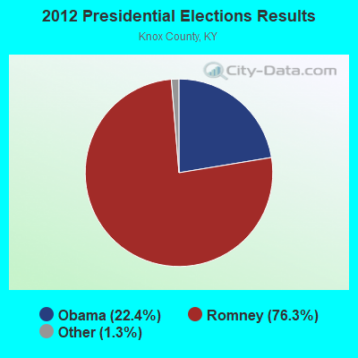
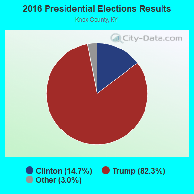
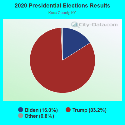
Graphs represent county-level data. Detailed 2008 Election Results
Religion statistics for Barbourville, KY (based on Knox County data)
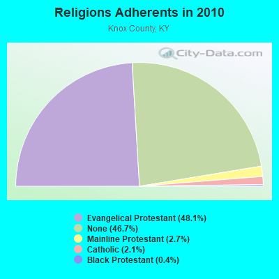
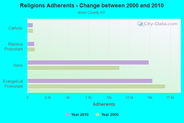
| Religion | Adherents | Congregations |
|---|---|---|
| Evangelical Protestant | 15,334 | 56 |
| Mainline Protestant | 859 | 5 |
| Catholic | 678 | 2 |
| Black Protestant | 123 | 1 |
| Other | - | 1 |
| None | 14,889 | - |
Food Environment Statistics:
| Knox County: | 2.77 / 10,000 pop. |
| Kentucky: | 2.19 / 10,000 pop. |
| Knox County: | 0.31 / 10,000 pop. |
| Kentucky: | 0.74 / 10,000 pop. |
| Knox County: | 3.38 / 10,000 pop. |
| State: | 4.36 / 10,000 pop. |
| Here: | 3.38 / 10,000 pop. |
| State: | 5.74 / 10,000 pop. |
| This county: | 11.6% |
| Kentucky: | 11.0% |
| Knox County: | 32.3% |
| Kentucky: | 30.0% |
| This county: | 21.0% |
| State: | 15.9% |
Health and Nutrition:
| Barbourville: | 49.0% |
| State: | 49.9% |
| Here: | 47.3% |
| Kentucky: | 47.0% |
| This city: | 28.5 |
| Kentucky: | 28.6 |
| This city: | 22.2% |
| Kentucky: | 21.0% |
| Barbourville: | 6.8% |
| Kentucky: | 10.1% |
| Barbourville: | 6.8 |
| State: | 6.8 |
| Here: | 31.4% |
| Kentucky: | 33.8% |
| This city: | 58.5% |
| State: | 56.8% |
| This city: | 78.2% |
| State: | 78.9% |
More about Health and Nutrition of Barbourville, KY Residents
| Local government employment and payroll (March 2022) | |||||
| Function | Full-time employees | Monthly full-time payroll | Average yearly full-time wage | Part-time employees | Monthly part-time payroll |
|---|---|---|---|---|---|
| Police Protection - Officers | 11 | $41,747 | $45,542 | 0 | $0 |
| Financial Administration | 11 | $19,113 | $20,851 | 1 | $1,112 |
| Streets and Highways | 8 | $21,612 | $32,418 | 0 | $0 |
| Housing and Community Development (Local) | 6 | $23,030 | $46,060 | 1 | $1,200 |
| Police - Other | 1 | $3,826 | $45,912 | 0 | $0 |
| Firefighters | 1 | $3,410 | $40,920 | 0 | $0 |
| Other and Unallocable | 0 | $0 | 1 | $1,129 | |
| Parks and Recreation | 0 | $0 | 2 | $1,200 | |
| Totals for Government | 38 | $112,738 | $35,601 | 5 | $4,641 |
Barbourville government finances - Expenditure in 2021 (per resident):
- Construction - Housing and Community Development: $87,000 ($27.56)
- Current Operations - Electric Utilities: $6,570,000 ($2081.09)
Water Utilities: $2,322,000 ($735.51)
Miscellaneous Commercial Activities - Other: $2,283,000 ($723.15)
Sewerage: $1,732,000 ($548.62)
Housing and Community Development: $986,000 ($312.32)
Police Protection: $837,000 ($265.13)
General - Other: $622,000 ($197.02)
Regular Highways: $565,000 ($178.97)
Parks and Recreation: $551,000 ($174.53)
Central Staff Services: $411,000 ($130.19)
Local Fire Protection: $90,000 ($28.51)
- General - Interest on Debt: $79,000 ($25.02)
- Intergovernmental to Local - Other - General - Other: $228,000 ($72.22)
- Other Capital Outlay - Water Utilities: $365,000 ($115.62)
Local Fire Protection: $276,000 ($87.42)
Miscellaneous Commercial Activities - Other: $225,000 ($71.27)
Police Protection: $209,000 ($66.20)
Parks and Recreation: $141,000 ($44.66)
Regular Highways: $135,000 ($42.76)
Sewerage: $78,000 ($24.71)
Electric Utilities: $38,000 ($12.04)
Central Staff Services: $14,000 ($4.43)
- Total Salaries and Wages: $3,910,000 ($1238.52)
- Water Utilities - Interest on Debt: $296,000 ($93.76)
Barbourville government finances - Revenue in 2021 (per resident):
- Charges - Miscellaneous Commercial Activities: $3,376,000 ($1069.37)
Sewerage: $1,371,000 ($434.27)
Housing and Community Development: $376,000 ($119.10)
Solid Waste Management: $358,000 ($113.40)
Other: $269,000 ($85.21)
Parks and Recreation: $78,000 ($24.71)
- Federal Intergovernmental - Housing and Community Development: $425,000 ($134.62)
Other: $86,000 ($27.24)
- Local Intergovernmental - General Local Government Support: $45,000 ($14.25)
- Miscellaneous - General Revenue - Other: $111,000 ($35.16)
Rents: $108,000 ($34.21)
Interest Earnings: $54,000 ($17.10)
Sale of Property: $53,000 ($16.79)
Fines and Forfeits: $47,000 ($14.89)
Donations From Private Sources: $4,000 ($1.27)
- Revenue - Electric Utilities: $7,862,000 ($2490.34)
Water Utilities: $2,673,000 ($846.69)
- State Intergovernmental - Other: $155,000 ($49.10)
- Tax - Individual Income: $764,000 ($242.00)
Other Selective Sales: $611,000 ($193.54)
Other: $603,000 ($191.00)
Property: $563,000 ($178.33)
Insurance Premiums Sales: $528,000 ($167.25)
Alcoholic Beverage License: $169,000 ($53.53)
Occupation and Business License - Other: $90,000 ($28.51)
Public Utilities Sales: $8,000 ($2.53)
Other License: $4,000 ($1.27)
Barbourville government finances - Debt in 2021 (per resident):
- Long Term Debt - Beginning Outstanding - Unspecified Public Purpose: $9,357,000 ($2963.89)
Outstanding Unspecified Public Purpose: $8,790,000 ($2784.29)
Retired Unspecified Public Purpose: $567,000 ($179.60)
Barbourville government finances - Cash and Securities in 2021 (per resident):
- Other Funds - Cash and Securities: $11,464,000 ($3631.30)
| Businesses in Barbourville, KY | ||||
| Name | Count | Name | Count | |
|---|---|---|---|---|
| AT&T | 1 | McDonald's | 1 | |
| Advance Auto Parts | 1 | Papa John's Pizza | 1 | |
| Arby's | 1 | Pizza Hut | 1 | |
| Best Western | 1 | RadioShack | 1 | |
| Burger King | 1 | Rite Aid | 1 | |
| Dairy Queen | 1 | Subway | 1 | |
| FedEx | 1 | Taco Bell | 1 | |
| GNC | 1 | U-Haul | 1 | |
| H&R Block | 1 | UPS | 1 | |
| KFC | 1 | Walgreens | 1 | |
| Lane Furniture | 1 | Walmart | 1 | |
| Little Caesars Pizza | 1 | Wendy's | 1 | |
| Long John Silver's | 1 | |||
Strongest AM radio stations in Barbourville:
- WYWY (950 AM; 1 kW; BARBOURVILLE, KY; Owner: BARBOURVILLE-COMMNITY BROADC/G CO IN)
- WKDP (1330 AM; 5 kW; CORBIN, KY; Owner: EUBANKS BROADCASTING, INC.)
- WEKC (710 AM; daytime; 4 kW; WILLIAMSBURG, KY; Owner: GERALD PARKS)
- WKVL (850 AM; daytime; 50 kW; KNOXVILLE, TN; Owner: HORNE RADIO, LLC)
- WMIK (560 AM; 2 kW; MIDDLESBORO, KY; Owner: GATEWAY BROADCASTING, INC.)
- WKLB (1290 AM; 5 kW; MANCHESTER, KY; Owner: BARKER BROADCASTING COMPANY, INC.)
- WCTT (680 AM; 1 kW; CORBIN, KY; Owner: ENCORE COMMUNICATIONS, INC)
- WANO (1230 AM; 1 kW; PINEVILLE, KY; Owner: CUMBERLAND MEDIA GROUP, INC.)
- WEZJ (1440 AM; 2 kW; WILLIAMSBURG, KY; Owner: WHITLEY BROADCASTING CO., INC.)
- WFSR (970 AM; 5 kW; HARLAN, KY; Owner: EASTERN BROADCASTING COMPAY)
- WHLN (1410 AM; 5 kW; HARLAN, KY)
- WHAS (840 AM; 50 kW; LOUISVILLE, KY; Owner: CLEAR CHANNEL BROADCASTING LICENSES, INC.)
- WFGW (1010 AM; 50 kW; BLACK MOUNTAIN, NC; Owner: BLUE RIDGE BROADCASTING CORP.)
Strongest FM radio stations in Barbourville:
- WKKQ (96.1 FM; BARBOURVILLE, KY; Owner: BARBOURVILLE COMMUNITY B/NG CO.INC.)
- WKDP-FM (99.5 FM; CORBIN, KY; Owner: EUBANKS BROADCASTING, INC.)
- WRIL (106.3 FM; PINEVILLE, KY; Owner: PINE HILLS BROADCASTING, INC.)
- WMIK-FM (92.7 FM; MIDDLESBORO, KY; Owner: GATEWAY BROADCASTING, INC.)
- WCTT-FM (107.3 FM; CORBIN, KY; Owner: ENCORE COMMUNICATIONS, INC.)
- WEKX (102.7 FM; JELLICO, TN; Owner: WHITLEY BROADCASTING CO., INC.)
- WWLT (103.1 FM; MANCHESTER, KY; Owner: VERNON R. BALDWIN, INC.)
- WEZJ-FM (104.3 FM; WILLIAMSBURG, KY; Owner: WHITLEY BROADCASTING CO., INC.)
- WCTU (105.9 FM; TAZEWELL, TN; Owner: STAIR COMPANY, INC)
- WDVX (89.9 FM; CLINTON, TN; Owner: CUMBERLAND COMMUNITIES COMMUNI CORP.)
- WYGE (92.3 FM; LONDON, KY; Owner: ETHEL HUFF BROADCASTING, LLC)
- WTUK (105.1 FM; HARLAN, KY; Owner: EASTERN BROADCASTING COMPANY)
- WSEH (102.7 FM; CUMBERLAND, KY; Owner: CUMBERLAND CITY BROADCASTING, INC.)
- WVCT (91.5 FM; KEAVY, KY; Owner: VICTORY TRAINING SCHOOL CORP.)
- WSGS (101.1 FM; HAZARD, KY; Owner: MOUNTAIN BROADCASTING SERVICE, INC.)
- WTBK (105.7 FM; MANCHESTER, KY; Owner: MANCHESTER COMMUNICATIONS, INC.)
- WIMZ-FM (103.5 FM; KNOXVILLE, TN; Owner: SOUTH CENTRAL COMM., CORP.)
- WAXM (93.5 FM; BIG STONE GAP, VA; Owner: VALLEY BROADCASTING, INC.)
- WOKI-FM (100.3 FM; OAK RIDGE, TN; Owner: OAK RIDGE FM, INC.)
- WZQQ (97.9 FM; HYDEN, KY; Owner: LESLIE COUNTY BROADCASTING, INC.)
TV broadcast stations around Barbourville:
- W07AH (Channel 7; BARBOURVILLE, KY; Owner: BARBOURVILLE AREA TELEVISION CORP.)
- W04AF (Channel 4; BARBOURVILLE, KY; Owner: BARBOURVILLE AREA TELEVISION CORP.)
- W33BK (Channel 33; CORBIN, KY; Owner: TRINITY BROADCASTING NETWORK)
- WVTN-LP (Channel 48; CORBIN, KY; Owner: VICTORY TRAINING SCHOOL CORP.)
- W39CK (Channel 20; CORBIN, KY; Owner: DEREK RAY EUBANKS)
- WAGV (Channel 44; HARLAN, KY; Owner: LIVING FAITH MINISTRIES, INC.)
- National Bridge Inventory (NBI) Statistics
- 25Number of bridges
- 266ft / 80.7mTotal length
- $1,293,000Total costs
- 84,721Total average daily traffic
- 8,381Total average daily truck traffic
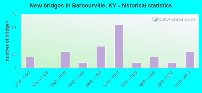
- New bridges - historical statistics
- 21920-1929
- 31940-1949
- 11950-1959
- 41960-1969
- 81970-1979
- 11980-1989
- 21990-1999
- 12000-2009
- 32010-2019
FCC Registered Antenna Towers:
22 (See the full list of FCC Registered Antenna Towers in Barbourville)FCC Registered Broadcast Land Mobile Towers:
13 (See the full list of FCC Registered Broadcast Land Mobile Towers in Barbourville, KY)FCC Registered Microwave Towers:
7- CALIFORNIA HOLLOW, 1.5m Sse Of Barbourville (Lat: 36.897500 Lon: -83.905278), Type: Tower, Structure height: 76.2 m, Overall height: 79.2 m, Call Sign: WMW513,
Assigned Frequencies: 6286.19 MHz, Grant Date: 01/26/2021, Expiration Date: 02/01/2031, Certifier: John T Scott Iii, Registrant: Verizon Wireless, 5055 North Point Pkwy, Np2ne Network Engineering, Alpharetta, GA 30022, Phone: (770) 797-1070, Email:
- BARBOURVILLE, Ky Hwy 2423 (Lat: 36.866333 Lon: -83.899694), Type: Mast, Structure height: 55.5 m, Overall height: 60.5 m, Call Sign: WPJB320,
Assigned Frequencies: 2178.00 MHz, Grant Date: 02/13/2001, Expiration Date: 02/01/2011, Cancellation Date: 10/09/2003, Certifier: Kellye E Abernathy, Registrant: Bellsouth Personal Communications, LLC, 17330 Preston Rd. Suite 100a, Dallas, TX 75252, Phone: (972) 733-2000, Fax: (972) 733-8141
- Various Locations (Lat: 36.883417 Lon: -83.899917), Overall height: 6.1 m, Call Sign: WPJD920,
Assigned Frequencies: 956.256 MHz, Grant Date: 03/01/2011, Expiration Date: 03/12/2021, Cancellation Date: 08/15/2017, Registrant: Delta Natural Gas Company Inc., 3617 Lexington Road, Winchester, KY 40391, Phone: (606) 744-6171
- LV72XC560, 166 Radio Tower Road (Lat: 36.866306 Lon: -83.899694), Type: Gtower, Structure height: 53.6 m, Call Sign: WQTH398,
Assigned Frequencies: 11545.0 MHz, 11545.0 MHz, 11545.0 MHz, 11545.0 MHz, 11545.0 MHz, 11545.0 MHz, Grant Date: 01/31/2014, Expiration Date: 01/31/2024, Cancellation Date: 05/10/2023, Certifier: David Werblow, Registrant: T-Mobile Usa, Inc., 12920 Se 38th Street, Bellevue, WA 98006, Phone: (425) 383-8401, Email:
- Barboursville, 0.8 Mile East Of (Lat: 36.872972 Lon: -83.866278), Type: Ltower, Structure height: 91.4 m, Overall height: 94.5 m, Call Sign: WRAT710,
Assigned Frequencies: 6389.96 MHz, 6389.96 MHz, 6389.96 MHz, 6389.96 MHz, 6389.96 MHz, 6389.96 MHz, Grant Date: 02/27/2018, Expiration Date: 02/27/2028, Certifier: Lynn Haney, Registrant: East Kentucky Network, LLC D/B/A Appalachian Wireless, 101 Technology Trail, Ivel, KY 41642, Phone: (606) 339-1006, Email:
- Booger MTN, 1500 Ft Off Hwy 25 Booger Mtn 6.7 Mi Nw Of (Lat: 36.942000 Lon: -83.963472), Type: Ltower, Structure height: 30.5 m, Overall height: 39.9 m, Call Sign: KIQ83,
Assigned Frequencies: 6404.79 MHz, 6725.00 MHz, 6123.10 MHz, 6785.00 MHz, 6226.89 MHz, 6256.54 MHz, 6315.84 MHz, Grant Date: 06/05/2019, Expiration Date: 08/11/2029, Registrant: Keller And Heckman LLP, 1001 G Street Nw, Suite 500 West, Washington, DC 20001, Phone: (202) 434-4100, Fax: (202) 434-4646, Email:
- STATION, 6.5 Mi Nw Of Barbourville At Johnson Hollow Forest Site (Lat: 36.945083 Lon: -83.968528), Overall height: 84.7 m, Call Sign: WEE403,
Assigned Frequencies: 2138.00 MHz, 2132.40 MHz, Grant Date: 09/01/2009, Expiration Date: 11/28/2019, Cancellation Date: 01/21/2011, Registrant: Kentucky Emergency Warning System, 85 State Police Road, London, KY 40741, Phone: (502) 564-5397, Email:
FCC Registered Amateur Radio Licenses:
49 (See the full list of FCC Registered Amateur Radio Licenses in Barbourville)FAA Registered Aircraft:
1- Aircraft: GRUMMAN AMERICAN AVN. CORP. AA-1B (Category: Land, Seats: 2, Weight: Up to 12,499 Pounds, Speed: 100 mph), Engine: LYCOMING 0-235 SERIES (115 HP) (Reciprocating)
N-Number: 1498R, N1498R, N-1498R, Serial Number: AA1B-0598, Year manufactured: 1975, Airworthiness Date: 01/24/1976, Certificate Issue Date: 11/05/2012
Registrant (Individual): Paul C Pedersen, 501 N Main St, Barbourville, KY 40906
2002 - 2018 National Fire Incident Reporting System (NFIRS) incidents
- Fire incident types reported to NFIRS in Barbourville, KY
- 26940.4%Structure Fires
- 25338.0%Outside Fires
- 11517.3%Mobile Property/Vehicle Fires
- 294.4%Other
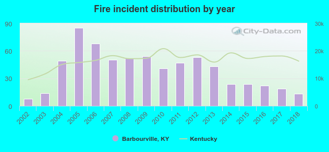 According to the data from the years 2002 - 2018 the average number of fire incidents per year is 39. The highest number of fires - 85 took place in 2005, and the least - 8 in 2002. The data has an increasing trend.
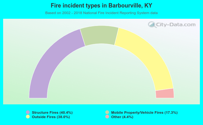 When looking into fire subcategories, the most reports belonged to: Structure Fires (40.4%), and Outside Fires (38.0%).
| Most common first names in Barbourville, KY among deceased individuals | ||
| Name | Count | Lived (average) |
|---|---|---|
| John | 101 | 74.0 years |
| William | 85 | 73.8 years |
| James | 80 | 71.5 years |
| Mary | 73 | 77.9 years |
| Charles | 50 | 69.3 years |
| George | 38 | 75.9 years |
| Martha | 36 | 80.3 years |
| Robert | 30 | 72.0 years |
| Ethel | 26 | 81.1 years |
| Bertha | 24 | 81.4 years |
| Most common last names in Barbourville, KY among deceased individuals | ||
| Last name | Count | Lived (average) |
|---|---|---|
| Smith | 137 | 72.6 years |
| Mills | 81 | 71.1 years |
| Jones | 58 | 73.9 years |
| Gray | 49 | 72.7 years |
| Davis | 41 | 78.2 years |
| Partin | 38 | 72.6 years |
| Hammons | 36 | 76.6 years |
| Broughton | 35 | 68.8 years |
| Brown | 35 | 75.7 years |
| Miller | 34 | 72.5 years |
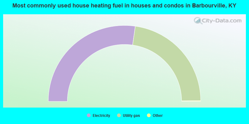
- 54.7%Electricity
- 45.3%Utility gas
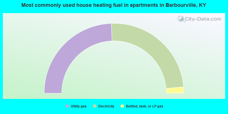
- 48.8%Utility gas
- 48.3%Electricity
- 2.9%Bottled, tank, or LP gas
Barbourville compared to Kentucky state average:
- Median household income significantly below state average.
- Black race population percentage significantly below state average.
- Hispanic race population percentage significantly below state average.
- Median age below state average.
- Foreign-born population percentage significantly below state average.
- Renting percentage above state average.
- Length of stay since moving in significantly above state average.
- House age above state average.
- Institutionalized population percentage above state average.
- Number of college students above state average.
- Percentage of population with a bachelor's degree or higher above state average.
Barbourville on our top lists:
- #41 on the list of "Top 101 cities with the largest percentage of people in wards in general hospitals for patients who have no usual home elsewhere (population 1,000+)"
- #89 on the list of "Top 101 cities with the most residents born in Oceania, n.e.c. (population 500+)"
- #46 on the list of "Top 101 counties with the smallest number of people without health insurance coverage in 2000"
- #81 on the list of "Top 101 counties with the smallest number of children under 18 without health insurance coverage in 2000"