Carlton, Wisconsin
Submit your own pictures of this town and show them to the world
- OSM Map
- Google Map
- MSN Map
Population change since 2000: +1.4%
 |
| Males: 538 | |
| Females: 476 |
| Median resident age: | 44.4 years |
| Wisconsin median age: | 42.6 years |
Zip codes: 54216.
| Carlton: | $87,155 |
| WI: | $70,996 |
Estimated per capita income in 2022: $42,613 (it was $20,660 in 2000)
Carlton town income, earnings, and wages data
Estimated median house or condo value in 2022: $219,648 (it was $98,900 in 2000)
| Carlton: | $219,648 |
| WI: | $252,800 |
Detailed information about poverty and poor residents in Carlton, WI
Compare current foreclosures near Carlton, WI:
| Photo | Address | Area | Beds / Baths | Price | Details |
|---|---|---|---|---|---|

|
#1
Colle St
Luxemburg, WI 54217
|
- sq. feet
|
2 baths 4 beds |
show details | |

|
#2
36th St
Two Rivers, WI 54241
|
1,528 sq. feet
|
1 baths 3 beds |
show details | |

|
#3
Margaretha St
Two Rivers, WI 54241
|
1,170 sq. feet
|
1 baths 2 beds |
show details | |

|
#4
43rd St
Two Rivers, WI 54241
|
2,280 sq. feet
|
1 baths 3 beds |
show details | |

|
#5
13th St
Two Rivers, WI 54241
|
1,632 sq. feet
|
1 baths 2 beds |
show details | |

|
#6
13th St
Two Rivers, WI 54241
|
1,782 sq. feet
|
2 baths 3 beds |
show details | |

|
#7
Emmet St
Two Rivers, WI 54241
|
1,124 sq. feet
|
1 baths 2 beds |
show details | |

|
#8
21st St
Two Rivers, WI 54241
|
900 sq. feet
|
1 baths 3 beds |
show details | |

|
#9
Garfield St
Two Rivers, WI 54241
|
1,038 sq. feet
|
1 baths 2 beds |
show details | |

|
#10
Green Bay Rd Apt 2
Denmark, WI 54208
|
- sq. feet
|
- baths - beds |
show details |
| Photo | Address | Area | Beds / Baths | Price | Details |
|---|---|---|---|---|---|

|
#11
Pleasant Rd
Casco, WI 54205
|
- sq. feet
|
- baths - beds |
show details | |

|
#12
Brookview Ct
Luxemburg, WI 54217
|
- sq. feet
|
- baths - beds |
show details | |

|
#13
20th St
Two Rivers, WI 54241
|
- sq. feet
|
- baths - beds |
show details | |

|
#14
Scott St Apt 10
Kewaunee, WI 54216
|
- sq. feet
|
- baths - beds |
show details | |

|
#15
County Road K
Luxemburg, WI 54217
|
- sq. feet
|
- baths - beds |
show details | |

|
#16
N County C
Casco, WI 54205
|
- sq. feet
|
- baths - beds |
show details | |

|
#17
County Rd S
Casco, WI 54205
|
- sq. feet
|
- baths - beds |
show details | |

|
#18
Morning Star Ln
Denmark, WI 54208
|
- sq. feet
|
- baths - beds |
show details | |

|
#19
Church Rd
Kewaunee, WI 54216
|
- sq. feet
|
- baths - beds |
show details | |

|
#20
Milwaukee St
Kewaunee, WI 54216
|
- sq. feet
|
- baths - beds |
show details |
| Photo | Address | Area | Beds / Baths | Price | Details |
|---|---|---|---|---|---|

|
#21
Lincoln St
Kewaunee, WI 54216
|
- sq. feet
|
- baths - beds |
show details | |

|
#22
Alfred Dr Apt 3e
Luxemburg, WI 54217
|
- sq. feet
|
- baths - beds |
show details | |

|
#23
County Road Jj
Green Bay, WI 54311
|
- sq. feet
|
- baths - beds |
show details | |

|
#24
4th Rd
Kewaunee, WI 54216
|
- sq. feet
|
- baths - beds |
show details | |

|
#25
1st St
Kewaunee, WI 54216
|
- sq. feet
|
- baths - beds |
show details | |

|
#26
County Road T
Casco, WI 54205
|
- sq. feet
|
- baths - beds |
show details | |

|
#27
W Main St
Mishicot, WI 54228
|
- sq. feet
|
- baths - beds |
show details | |

|
#28
Jorgensen St
Denmark, WI 54208
|
- sq. feet
|
- baths - beds |
show details | |

|
#29
Ellis St
Kewaunee, WI 54216
|
- sq. feet
|
- baths - beds |
show details | |

|
#30
Vliet St
Kewaunee, WI 54216
|
- sq. feet
|
- baths - beds |
show details |
| Photo | Address | Area | Beds / Baths | Price | Details |
|---|---|---|---|---|---|

|
#31
2nd St
Kewaunee, WI 54216
|
- sq. feet
|
- baths - beds |
show details | |

|
#32
Washington St
Mishicot, WI 54228
|
- sq. feet
|
- baths - beds |
show details | |

|
#33
N Lake Rd
Mishicot, WI 54228
|
- sq. feet
|
- baths - beds |
show details | |

|
#34
Depere Rd
Denmark, WI 54208
|
- sq. feet
|
- baths - beds |
show details | |

|
#35
Buchanan St
Mishicot, WI 54228
|
- sq. feet
|
- baths - beds |
show details | |

|
#36
Johnston Dr
Two Rivers, WI 54241
|
- sq. feet
|
- baths - beds |
show details | |

|
#37
Ridge Park Ct
Denmark, WI 54208
|
- sq. feet
|
- baths - beds |
show details | |

|
#38
Elm St
Denmark, WI 54208
|
- sq. feet
|
- baths - beds |
show details | |

|
#39
Adams St
Algoma, WI 54201
|
- sq. feet
|
- baths - beds |
show details | |

|
Check over 1 million property listings on Foreclosure.com!
|
browse all offers | |||

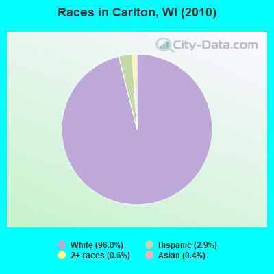
- 97396.0%White alone
- 292.9%Hispanic
- 60.6%Two or more races
- 40.4%Asian alone
- 10.10%Black alone
- 10.10%American Indian alone
Races in Carlton detailed stats: ancestries, foreign born residents, place of birth
 Recent articles from our blog. Our writers, many of them Ph.D. graduates or candidates, create easy-to-read articles on a wide variety of topics.
Ancestries: German (48.6%), Czech (31.1%), Polish (17.7%), Irish (6.9%), Norwegian (4.4%), Swedish (3.2%).
Current Local Time: CST time zone
Land area: 35.6 square miles.
Population density: 28 people per square mile (very low).
5 residents are foreign born
| This town: | 0.5% |
| Wisconsin: | 3.6% |
| Carlton town: | 1.1% ($1,125) |
| Wisconsin: | 2.0% ($2,245) |
Nearest city with pop. 50,000+: Green Bay, WI  (23.6 miles , pop. 102,313).
Nearest city with pop. 200,000+: Milwaukee, WI (93.6 miles , pop. 596,974).
Nearest city with pop. 1,000,000+: Chicago, IL (175.6 miles , pop. 2,896,016).
Nearest cities:
), ), ), ), ), )Latitude: 44.38 N, Longitude: 87.58 W
Area code commonly used in this area: 920
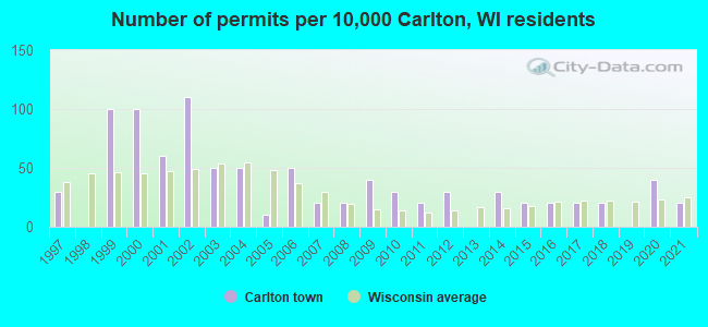
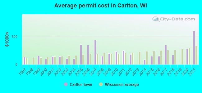
Single-family new house construction building permits:
- 2021: 2 buildings, average cost: $600,000
- 2020: 4 buildings, average cost: $278,400
- 2018: 2 buildings, average cost: $175,000
- 2017: 2 buildings, average cost: $352,000
- 2016: 2 buildings, average cost: $150,000
- 2015: 2 buildings, average cost: $150,000
- 2014: 3 buildings, average cost: $87,700
- 2012: 3 buildings, average cost: $183,300
- 2011: 2 buildings, average cost: $250,000
- 2010: 3 buildings, average cost: $233,300
- 2009: 4 buildings, average cost: $200,000
- 2008: 2 buildings, average cost: $150,000
- 2007: 2 buildings, average cost: $445,000
- 2006: 5 buildings, average cost: $350,000
- 2005: 1 building, cost: $361,000
- 2004: 5 buildings, average cost: $97,800
- 2003: 5 buildings, average cost: $109,400
- 2002: 11 buildings, average cost: $143,500
- 2001: 6 buildings, average cost: $146,700
- 2000: 10 buildings, average cost: $99,700
- 1999: 10 buildings, average cost: $153,800
- 1997: 3 buildings, average cost: $133,000
| Here: | 2.3% |
| Wisconsin: | 2.7% |
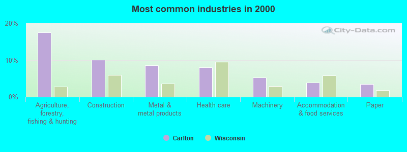
- Agriculture, forestry, fishing & hunting (17.5%)
- Construction (10.1%)
- Metal & metal products (8.6%)
- Health care (7.9%)
- Machinery (5.3%)
- Accommodation & food services (3.8%)
- Paper (3.5%)
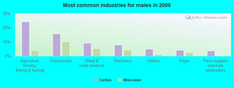
- Agriculture, forestry, fishing & hunting (24.1%)
- Construction (15.7%)
- Metal & metal products (9.0%)
- Machinery (7.8%)
- Utilities (4.9%)
- Paper (4.1%)
- Farm supplies merchant wholesalers (3.8%)
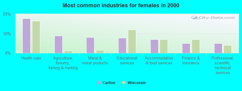
- Health care (17.7%)
- Agriculture, forestry, fishing & hunting (8.8%)
- Metal & metal products (8.1%)
- Educational services (7.7%)
- Accommodation & food services (6.9%)
- Finance & insurance (5.0%)
- Professional, scientific, technical services (5.0%)
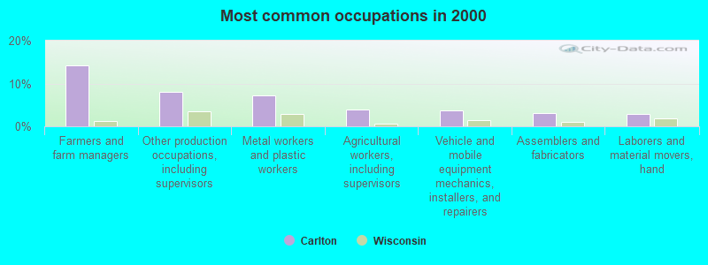
- Farmers and farm managers (14.2%)
- Other production occupations, including supervisors (7.9%)
- Metal workers and plastic workers (7.1%)
- Agricultural workers, including supervisors (4.0%)
- Vehicle and mobile equipment mechanics, installers, and repairers (3.8%)
- Assemblers and fabricators (3.1%)
- Laborers and material movers, hand (2.8%)
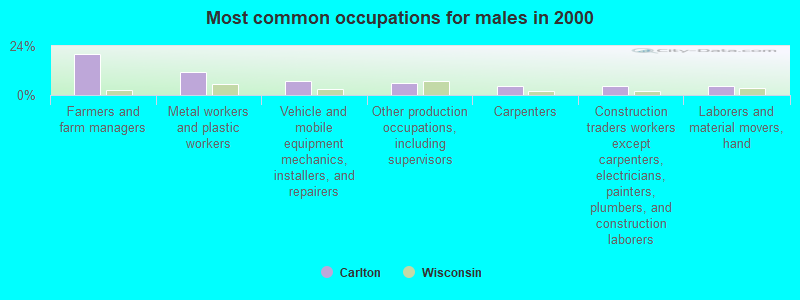
- Farmers and farm managers (20.1%)
- Metal workers and plastic workers (11.0%)
- Vehicle and mobile equipment mechanics, installers, and repairers (6.7%)
- Other production occupations, including supervisors (6.1%)
- Carpenters (4.7%)
- Construction traders workers except carpenters, electricians, painters, plumbers, and construction laborers (4.4%)
- Laborers and material movers, hand (4.4%)
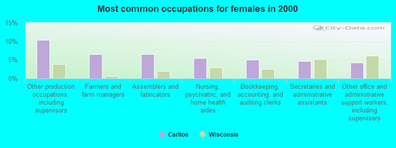
- Other production occupations, including supervisors (10.4%)
- Farmers and farm managers (6.5%)
- Assemblers and fabricators (6.5%)
- Nursing, psychiatric, and home health aides (5.4%)
- Bookkeeping, accounting, and auditing clerks (5.0%)
- Secretaries and administrative assistants (4.6%)
- Other office and administrative support workers, including supervisors (4.2%)
Average climate in Carlton, Wisconsin
Based on data reported by over 4,000 weather stations


(lower is better)
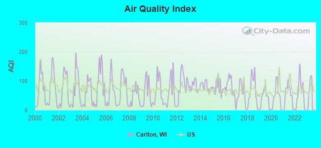
Air Quality Index (AQI) level in 2022 was 53.5. This is better than average.
| City: | 53.5 |
| U.S.: | 72.6 |
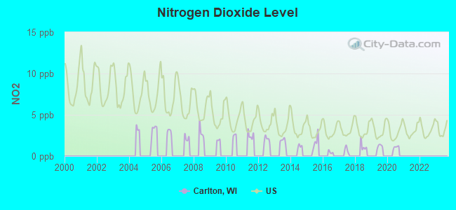
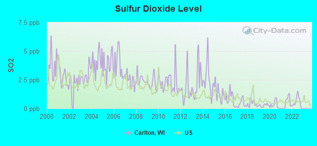
Sulfur Dioxide (SO2) [ppb] level in 2022 was 0.556. This is significantly better than average. Closest monitor was 19.6 miles away from the city center.
| City: | 0.556 |
| U.S.: | 1.515 |
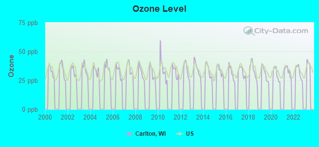
Ozone [ppb] level in 2022 was 32.4. This is about average. Closest monitor was 5.9 miles away from the city center.
| City: | 32.4 |
| U.S.: | 33.3 |
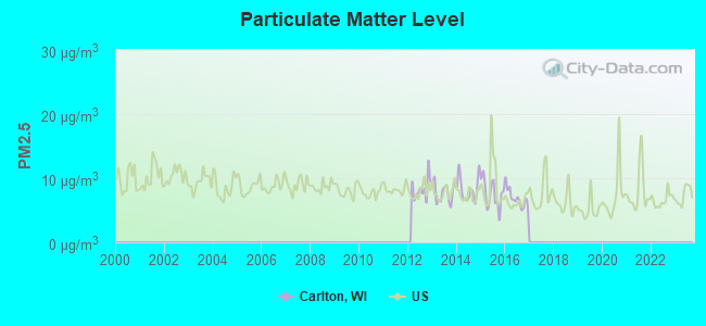
Particulate Matter (PM2.5) [µg/m3] level in 2016 was 6.90. This is about average. Closest monitor was 16.7 miles away from the city center.
| City: | 6.90 |
| U.S.: | 8.11 |
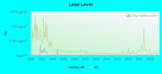
Lead (Pb) [µg/m3] level in 2002 was 0.00649. This is significantly better than average. Closest monitor was 19.6 miles away from the city center.
| City: | 0.00649 |
| U.S.: | 0.00931 |
Tornado activity:
Carlton-area historical tornado activity is below Wisconsin state average. It is 28% smaller than the overall U.S. average.
On 7/5/1994, a category F4 (max. wind speeds 207-260 mph) tornado 10.3 miles away from the Carlton town center injured 2 people and caused between $500,000 and $5,000,000 in damages.
On 4/27/1984, a category F4 tornado 36.0 miles away from the town center killed one person and injured 19 people and caused between $500,000 and $5,000,000 in damages.
Earthquake activity:
Carlton-area historical earthquake activity is significantly above Wisconsin state average. It is 27% smaller than the overall U.S. average.On 5/2/2015 at 16:23:07, a magnitude 4.2 (4.2 MW, Depth: 2.8 mi, Class: Light, Intensity: IV - V) earthquake occurred 183.5 miles away from the city center
On 4/18/2008 at 09:36:59, a magnitude 5.4 (5.1 MB, 4.8 MS, 5.4 MW, 5.2 MW, Class: Moderate, Intensity: VI - VII) earthquake occurred 410.2 miles away from the city center
On 6/28/2004 at 06:10:52, a magnitude 4.2 (4.2 MW, Depth: 6.2 mi) earthquake occurred 212.7 miles away from the city center
On 6/10/1987 at 23:48:54, a magnitude 5.1 (4.9 MB, 4.4 MS, 4.6 MS, 5.1 LG) earthquake occurred 384.7 miles away from Carlton center
On 1/31/1986 at 16:46:43, a magnitude 5.0 (5.0 MB) earthquake occurred 377.1 miles away from the city center
On 4/18/2008 at 09:36:59, a magnitude 5.2 (5.2 MW, Depth: 8.9 mi) earthquake occurred 410.2 miles away from Carlton center
Magnitude types: regional Lg-wave magnitude (LG), body-wave magnitude (MB), surface-wave magnitude (MS), moment magnitude (MW)
Natural disasters:
The number of natural disasters in Kewaunee County (6) is a lot smaller than the US average (15).Major Disasters (Presidential) Declared: 3
Emergencies Declared: 3
Causes of natural disasters: Floods: 2, Storms: 2, Drought: 1, Hurricane: 1, Tornado: 1, Winter Storm: 1, Other: 1 (Note: some incidents may be assigned to more than one category).
Hospitals and medical centers near Carlton:
Nuclear power plants:
Kewaunee . Westinghouse Electric Corp.Fluor. Westinghouse Electric Corp.Wisconsin Public Service Corp.Pressurized Water Reactor (PWR). Net Output: 503 MWe. Operable. Initial criticality: 03/1974. Commercial start: 06/1974..
Colleges/universities with over 2000 students nearest to Carlton:
- University of Wisconsin-Green Bay (about 20 miles; Green Bay, WI; Full-time enrollment: 5,415)
- Saint Norbert College (about 25 miles; De Pere, WI; FT enrollment: 2,324)
- Northeast Wisconsin Technical College (about 29 miles; Green Bay, WI; FT enrollment: 6,069)
- Lakeland College (about 41 miles; Plymouth, WI; FT enrollment: 2,395)
- Lawrence University (about 42 miles; Appleton, WI; FT enrollment: 2,821)
- Fox Valley Technical College (about 45 miles; Appleton, WI; FT enrollment: 5,682)
- University of Wisconsin-Oshkosh (about 55 miles; Oshkosh, WI; FT enrollment: 10,637)
Points of interest:
Notable locations in Carlton: Kewoc Dairy Farm (A), Hardtke Farms (B), Klimesh Dairy Farm (C), Langer Farms (D), Rabas Dairy Farm (E), Mueller Farms (F), Paplham Dairy (G), Schleis Farms (H), Stangel Farms (I), Sandy Bay (J), Dominion Energy Kewaunee Nuclear Plant Fire Brigade (K), Carlton Town Volunteer Fire Department (L), Tisch Mills Fire Department (M). Display/hide their locations on the map
Churches in Carlton include: Saint Joseph Catholic Church (A), Saint Peters Church (B). Display/hide their locations on the map
Cemeteries: Sandy Bay Cemetery (1), Norman Cemetery (2), Saint Josephs Catholic Cemetery (3), Saint Peters Cemetery (4), Volunteer Cemetery (5), Saint Peters Cemetery (6), Forest View Cemetery (7). Display/hide their locations on the map
Reservoir: 0.4 Reservoir (A). Display/hide its location on the map
| This town: | 2.5 people |
| Wisconsin: | 2.4 people |
| This town: | 72.4% |
| Whole state: | 64.4% |
| This town: | 5.4% |
| Whole state: | 7.3% |
Likely homosexual households (counted as self-reported same-sex unmarried-partner households)
- Lesbian couples: 0.2% of all households
- Gay men: 0.0% of all households
| This town: | 3.0% |
| Whole state: | 8.7% |
| This town: | 2.1% |
| Whole state: | 3.7% |
For population 15 years and over in Carlton:
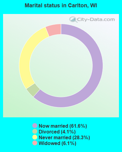
- Never married: 28.3%
- Now married: 61.6%
- Separated: 0.0%
- Widowed: 6.1%
- Divorced: 4.1%
For population 25 years and over in Carlton:
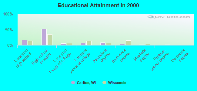
- High school or higher: 83.0%
- Bachelor's degree or higher: 7.9%
- Graduate or professional degree: 3.0%
- Unemployed: 3.8%
- Mean travel time to work (commute): 26.5 minutes
| Here: | 9.0 |
| Wisconsin average: | 11.0 |
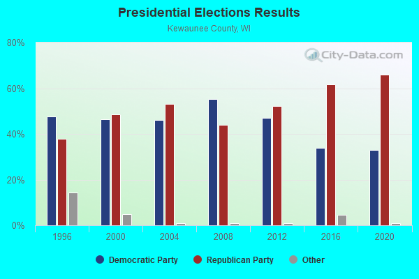
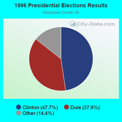
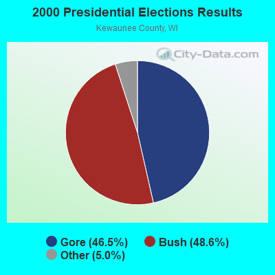
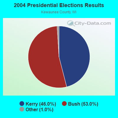
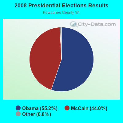
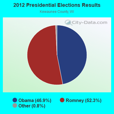
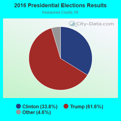
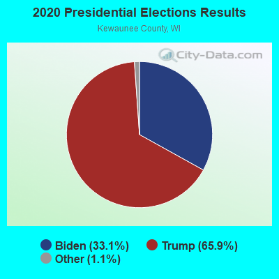
Graphs represent county-level data. Detailed 2008 Election Results
Religion statistics for Carlton, WI (based on Kewaunee County data)
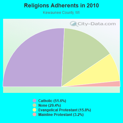
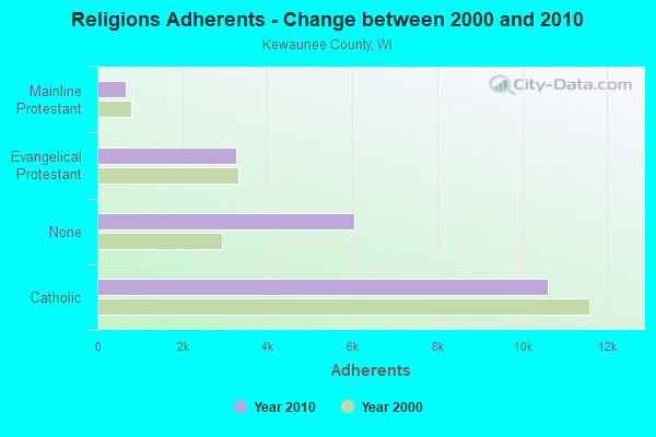
| Religion | Adherents | Congregations |
|---|---|---|
| Catholic | 10,606 | 7 |
| Evangelical Protestant | 3,257 | 10 |
| Mainline Protestant | 663 | 5 |
| Other | 8 | 1 |
| None | 6,040 | - |
Food Environment Statistics:
| Kewaunee County: | 2.44 / 10,000 pop. |
| Wisconsin: | 1.86 / 10,000 pop. |
| This county: | 6.35 / 10,000 pop. |
| Wisconsin: | 4.12 / 10,000 pop. |
| This county: | 11.73 / 10,000 pop. |
| Wisconsin: | 8.64 / 10,000 pop. |
| This county: | 7.9% |
| Wisconsin: | 7.6% |
| Kewaunee County: | 29.9% |
| Wisconsin: | 27.5% |
| This county: | 14.5% |
| State: | 13.0% |
Strongest AM radio stations in Carlton:
- WNAM (1280 AM; 50 kW; NEENAH-MENASHA, WI; Owner: CUMULUS LICENSING CORP.)
- WTAQ (1360 AM; 10 kW; GREEN BAY, WI; Owner: MIDWEST COMMUNICATIONS, INC.)
- WCUB (980 AM; 5 kW; TWO RIVERS, WI; Owner: CUB RADIO, INC.)
- WHBY (1150 AM; 25 kW; KIMBERLY, WI; Owner: WOODWARD COMMUNICATIONS, INC.)
- WNFL (1440 AM; 5 kW; GREEN BAY, WI; Owner: MIDWEST COMMUNICATIONS, INC.)
- WTCM (580 AM; 35 kW; TRAVERSE CITY, MI; Owner: WTCM RADIO, INC.)
- WTMJ (620 AM; 50 kW; MILWAUKEE, WI; Owner: JOURNAL BROADCAST CORPORATION)
- WSPT (1010 AM; 50 kW; STEVENS POINT, WI)
- WLDR (1210 AM; daytime; 50 kW; KINGSLEY, MI; Owner: FORT BEND BROADCASTING COMPANY)
- WISN (1130 AM; 50 kW; MILWAUKEE, WI; Owner: CAPSTAR TX LIMITED PARTNERSHIP)
- WTRW (1590 AM; 1 kW; TWO RIVERS, WI; Owner: WTRW, INC.)
- WSAU (550 AM; 20 kW; WAUSAU, WI; Owner: WRIG, INC.)
- WOMT (1240 AM; 1 kW; MANITOWOC, WI; Owner: SEEHAFER BROADCASTING CORP)
Strongest FM radio stations in Carlton:
- WAUN-FM (92.7 FM; KEWAUNEE, WI; Owner: MAGNUM BROADCASTING, INC.)
- WHID (88.1 FM; GREEN BAY, WI; Owner: BD OF REGENTS OF THE UNIV OF WI SYS)
- WIXX (101.1 FM; GREEN BAY, WI; Owner: MIDWEST COMMUNICATIONS, INC.)
- WXWX (107.5 FM; BRILLION, WI; Owner: CUMULUS LICENSING CORP.)
- WPNE-FM (89.3 FM; GREEN BAY, WI; Owner: WISCONSIN EDUCATIONAL COMMUNICATIONS BOARD)
- WZOR (94.7 FM; MISHICOT, WI; Owner: WOODWARD COMMUNICATIONS, INC.)
- WEMY (91.5 FM; GREEN BAY, WI; Owner: EVANGEL MINISTRIES, INC)
- WOGB (103.1 FM; KAUKAUNA, WI; Owner: CUMULUS LICENSING CORP.)
- WLYD (99.7 FM; STURGEON BAY, WI; Owner: MIDWEST COMMUNICATIONS INC)
- WKSZ (95.9 FM; DE PERE, WI; Owner: WOODWARD COMMUNICATIONS INC)
- WORQ (90.1 FM; GREEN BAY, WI; Owner: LAKESHORE COMMUNICATIONS, INC.)
- WBDK (96.7 FM; ALGOMA, WI; Owner: NICOLET BROADCASTING, INC.)
- WJLW (106.7 FM; ALLOUEZ, WI; Owner: CUMULUS LICENSING CORP)
- WLTU (92.1 FM; MANITOWOC, WI; Owner: CUB RADIO, INC.)
- WAPL-FM (105.7 FM; APPLETON, WI; Owner: WOODWARD COMMUNICATIONS, INC.)
- WRLU (104.1 FM; ALGOMA, WI; Owner: NICOLET BROADCASTING, INC.)
- W270AJ (101.9 FM; GREEN BAY, WI; Owner: MIDWEST COMMUNICATIONS, INC)
- WQTC-FM (102.3 FM; MANITOWOC, WI; Owner: SEEHAFER BROADCASTING CORPORATION)
- WRKU (102.1 FM; FORESTVILLE, WI; Owner: NICOLET BROADCASTING, INC.)
- W215BF (90.9 FM; MANITOWOC, WI; Owner: CALVARY CHAPEL OF TWIN FALLS, INC.)
TV broadcast stations around Carlton:
- WLUK-TV (Channel 11; GREEN BAY, WI; Owner: EMMIS TELEVISION LICENSE CORPORATION)
- WFRV-TV (Channel 5; GREEN BAY, WI; Owner: CBS BROADCASTING INC.)
- WBAY-TV (Channel 2; GREEN BAY, WI; Owner: YOUNG BROADCASTING OF GREEN BAY, INC.)
- WPNE (Channel 38; GREEN BAY, WI; Owner: WISCONSIN EDUCATIONAL COMMUNICATIONS BOARD)
- WGBA (Channel 26; GREEN BAY, WI; Owner: ARIES TELECOMMUNICATION CORPORATION)
- WACY (Channel 32; APPLETON, WI; Owner: ACE TV, INC.)
- W49CB (Channel 49; GREEN BAY, WI; Owner: TRINITY BROADCASTING NETWORK)
- WIWB (Channel 14; SURING, WI; Owner: ACME TV LICENSES OF WISCONSIN, LLC)
- W30BU (Channel 30; GREEN BAY, WI; Owner: THREE ANGELS BROADCASTING NETWORK)
- WMMF-TV (Channel 68; FOND DU LAC, WI; Owner: PAPPAS TELECASTING OF WISCONSIN, A CALIFORNIA LTD PARTNRSHP)
- National Bridge Inventory (NBI) Statistics
- 18Number of bridges
- 125ft / 38.4mTotal length
- $372,000Total costs
- 23,358Total average daily traffic
- 1,255Total average daily truck traffic
- 27,615Total future (year 2037) average daily traffic
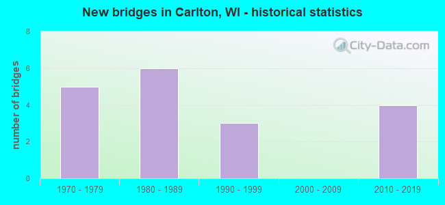
- New bridges - historical statistics
- 51970-1979
- 61980-1989
- 31990-1999
- 42010-2019
FCC Registered Broadcast Land Mobile Towers:
2- Hwy 42 Electric Generating Plant (Lat: 44.342222 Lon: -87.535639), Call Sign: KNCE247,
Assigned Frequencies: 47.7400 MHz, Grant Date: 01/17/2014, Expiration Date: 10/17/2023, Cancellation Date: 07/28/2022, Certifier: Bradley R Carroll Sr., Registrant: Dominion Services, Inc., 707 E Main Street, Richmond, VA 23261, Phone: (804) 775-5170, Fax: (804) 389-9738, Email:
- Lat: 44.340556 Lon: -87.536389, Structure height: 0 m, Call Sign: WPWS681,
Assigned Frequencies: 456.225 MHz, Grant Date: 12/04/2012, Expiration Date: 01/15/2023, Cancellation Date: 07/28/2022, Certifier: Bradley R Carroll Sr., Registrant: Dominion Services, Inc., 707 E Main Street, Richmond, VA 23261, Phone: (804) 775-5170, Fax: (804) 389-9738, Email:
FCC Registered Microwave Towers:
1- STATION, Hwy 42 Kewaunee Nuclear Plnt (Lat: 44.341083 Lon: -87.540611), Overall height: 71.3 m, Call Sign: WNTA237,
Assigned Frequencies: 6345.49 MHz, 6256.54 MHz, Grant Date: 01/23/2010, Expiration Date: 02/23/2020, Cancellation Date: 06/18/2019,
FCC Registered Maritime Coast & Aviation Ground Towers:
1- N490 Hwy 42 (Lat: 44.341861 Lon: -87.546389), Type: Pipe, Structure height: 10 m, Overall height: 12 m, Call Sign: WQBN496,
Assigned Frequencies: 9410.00 MHz, Grant Date: 09/23/2014, Expiration Date: 11/10/2024, Cancellation Date: 07/28/2022, Certifier: Bradley R Carroll Sr., Registrant: Dominion Services, Inc., 707 E Main Street, Richmond, VA 23261, Phone: (804) 775-5170, Fax: (804) 389-9738, Email:
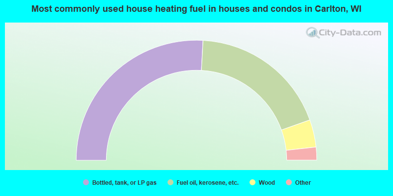
- 51.8%Bottled, tank, or LP gas
- 37.4%Fuel oil, kerosene, etc.
- 7.4%Wood
- 2.1%Electricity
- 0.9%Utility gas
- 0.6%Coal or coke
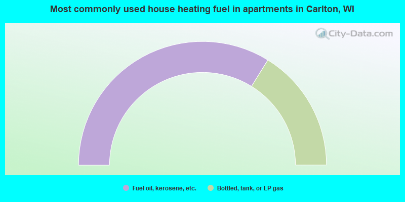
- 67.7%Fuel oil, kerosene, etc.
- 32.3%Bottled, tank, or LP gas
Carlton compared to Wisconsin state average:
- Unemployed percentage significantly below state average.
- Black race population percentage significantly below state average.
- Hispanic race population percentage below state average.
- Foreign-born population percentage significantly below state average.
- Renting percentage significantly below state average.
- Length of stay since moving in significantly above state average.
- Number of rooms per house significantly below state average.
- House age significantly below state average.
- Number of college students below state average.
- Percentage of population with a bachelor's degree or higher significantly below state average.