Chestnut Hill, Tennessee
Submit your own pictures of this place and show them to the world
- OSM Map
- General Map
- Google Map
- MSN Map

| Males: 2,092 | |
| Females: 2,054 |
| Median resident age: | 41.5 years |
| Tennessee median age: | 35.9 years |
Zip code: 37725
| Chestnut Hill: | $59,801 |
| TN: | $65,254 |
Estimated per capita income in 2022: $32,466 (it was $16,805 in 2000)
Chestnut Hill CCD income, earnings, and wages data
Estimated median house or condo value in 2022: $220,521 (it was $79,200 in 2000)
| Chestnut Hill: | $220,521 |
| TN: | $284,800 |
Detailed information about poverty and poor residents in Chestnut Hill, TN
Compare current foreclosures near Chestnut Hill, TN:
| Photo | Address | Area | Beds / Baths | Price | Details |
|---|---|---|---|---|---|

|
#1
Chestnut Hill School Rd
Dandridge, TN 37725
|
1,216 sq. feet
|
1 baths - beds |
$39,900
|
show details |

|
#2
Highway 25 32
White Pine, TN 37890
|
1,428 sq. feet
|
1 baths 3 beds |
show details | |

|
#3
Mcgaha Hollow Rd
Dandridge, TN 37725
|
1,620 sq. feet
|
2 baths 3 beds |
show details | |

|
#4
Cherrybrook Ln
Talbott, TN 37877
|
1,400 sq. feet
|
2 baths 3 beds |
show details | |

|
#5
Jesse Baker Ln
Jefferson City, TN 37760
|
- sq. feet
|
2 baths 4 beds |
show details | |

|
#6
Deer Meadows Rd
Sevierville, TN 37862
|
1,548 sq. feet
|
3 baths 3 beds |
show details | |

|
#7
Lyle Rd
Dandridge, TN 37725
|
1,428 sq. feet
|
3 baths 2 beds |
show details | |

|
#8
Southview Cir
Kodak, TN 37764
|
2,031 sq. feet
|
2 baths 3 beds |
show details | |

|
#9
Aspen Rd
Newport, TN 37821
|
1,972 sq. feet
|
2 baths 3 beds |
show details | |

|
#10
Rogers Pl
Sevierville, TN 37876
|
2,128 sq. feet
|
2 baths - beds |
show details |
| Photo | Address | Area | Beds / Baths | Price | Details |
|---|---|---|---|---|---|

|
#11
Brookline Ct
Jefferson City, TN 37760
|
1,316 sq. feet
|
3 baths - beds |
show details | |

|
#12
Guinn Dr
New Market, TN 37820
|
2,280 sq. feet
|
2 baths 3 beds |
show details | |

|
#13
4th St
Newport, TN 37821
|
1,138 sq. feet
|
1 baths - beds |
show details | |

|
#14
Old Newport Hwy
Sevierville, TN 37876
|
1,428 sq. feet
|
1 baths - beds |
show details | |

|
#15
Bob O Dr
Dandridge, TN 37725
|
2,147 sq. feet
|
3 baths 3 beds |
show details | |

|
#16
Deerfoot Rd
Cosby, TN 37722
|
- sq. feet
|
2 baths 4 beds |
show details | |

|
#17
Smith School Rd
Kodak, TN 37764
|
938 sq. feet
|
1 baths 2 beds |
show details | |

|
#18
Clark Ln
Dandridge, TN 37725
|
2,096 sq. feet
|
2 baths 2 beds |
show details | |

|
#19
Douglas St
White Pine, TN 37890
|
1,128 sq. feet
|
1 baths - beds |
show details | |

|
#20
Edwina Bridgeport Rd
Newport, TN 37821
|
900 sq. feet
|
1 baths - beds |
show details |
| Photo | Address | Area | Beds / Baths | Price | Details |
|---|---|---|---|---|---|

|
#21
Clear Creek Rd
Newport, TN 37821
|
1,356 sq. feet
|
1 baths - beds |
show details | |

|
#22
Catlett Dr
Sevierville, TN 37876
|
1,056 sq. feet
|
2 baths - beds |
show details | |

|
#23
Crestview Dr
Talbott, TN 37877
|
2,100 sq. feet
|
1 baths - beds |
show details | |

|
#24
Brooks Dr
Talbott, TN 37877
|
1,183 sq. feet
|
1 baths - beds |
show details | |

|
#25
Sockless Rd
Dandridge, TN 37725
|
1,100 sq. feet
|
3 baths - beds |
show details | |

|
#26
Monterey Rd
Talbott, TN 37877
|
1,240 sq. feet
|
1 baths - beds |
show details | |

|
#27
Cabbage County Rd
Hartford, TN 37753
|
984 sq. feet
|
1 baths - beds |
show details | |

|
#28
Woodlawn Ave
Newport, TN 37821
|
2,224 sq. feet
|
1 baths - beds |
show details | |

|
#29
Constitution Dr
Jefferson City, TN 37760
|
1,947 sq. feet
|
3 baths - beds |
show details | |

|
#30
Black Rd
Dandridge, TN 37725
|
1,944 sq. feet
|
2 baths - beds |
show details |
| Photo | Address | Area | Beds / Baths | Price | Details |
|---|---|---|---|---|---|

|
#31
Seehorn Dr
Newport, TN 37821
|
1,305 sq. feet
|
1 baths - beds |
show details | |

|
#32
Briarwood Way
Newport, TN 37821
|
1,824 sq. feet
|
2 baths - beds |
show details | |

|
#33
Hollow Oak Rd
Newport, TN 37821
|
1,013 sq. feet
|
1 baths - beds |
show details | |

|
#34
Creekside Way
Jefferson City, TN 37760
|
2,164 sq. feet
|
3 baths - beds |
show details | |

|
#35
Buell St
Talbott, TN 37877
|
1,850 sq. feet
|
1 baths - beds |
show details | |

|
#36
Twin Oaks Rd
Sevierville, TN 37876
|
1,092 sq. feet
|
2 baths - beds |
show details | |

|
#37
Wells Rd
Talbott, TN 37877
|
900 sq. feet
|
1 baths - beds |
show details | |

|
#38
Riverview Cir
Sevierville, TN 37862
|
1,493 sq. feet
|
2 baths - beds |
show details | |

|
#39
Lower English Creek Rd
Newport, TN 37821
|
1,152 sq. feet
|
2 baths - beds |
show details | |

|
#40
Fontana St
Newport, TN 37821
|
1,610 sq. feet
|
2 baths - beds |
show details |
| Photo | Address | Area | Beds / Baths | Price | Details |
|---|---|---|---|---|---|

|
#41
Nell Rose Ln
Gatlinburg, TN 37738
|
2,475 sq. feet
|
2 baths - beds |
show details | |

|
#42
Highway 25 32
White Pine, TN 37890
|
1,064 sq. feet
|
1 baths - beds |
show details | |

|
#43
Blueberry Way
Newport, TN 37821
|
1,998 sq. feet
|
2 baths - beds |
show details | |

|
#44
Good Hope Rd
Parrottsville, TN 37843
|
1,080 sq. feet
|
1 baths - beds |
show details | |

|
#45
Rolling Meadows Dr
New Market, TN 37820
|
2,052 sq. feet
|
2 baths - beds |
show details | |

|
#46
Apricot Rd
Cosby, TN 37722
|
1,647 sq. feet
|
2 baths - beds |
show details | |

|
#47
Lake View Loop
Sevierville, TN 37876
|
600 sq. feet
|
1 baths - beds |
show details | |

|
#48
Highway 160
Newport, TN 37821
|
1,392 sq. feet
|
1 baths - beds |
show details | |

|
#49
Bernie Cir
Talbott, TN 37877
|
1,431 sq. feet
|
2 baths - beds |
show details | |

|
Check over 1 million property listings on Foreclosure.com!
|
browse all offers | |||

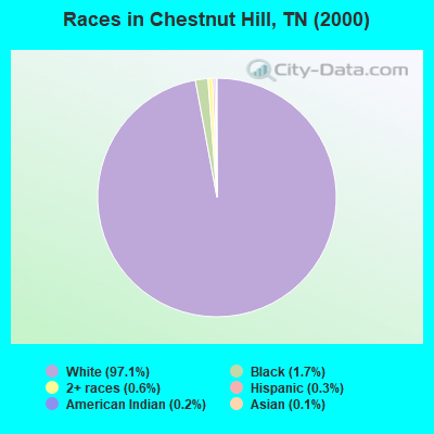
- 3,56097.1%White alone
- 621.7%Black alone
- 210.6%Two or more races
- 120.3%Hispanic
- 70.2%American Indian alone
- 40.1%Asian alone
Races in Chestnut Hill detailed stats: ancestries, foreign born residents, place of birth
 Recent articles from our blog. Our writers, many of them Ph.D. graduates or candidates, create easy-to-read articles on a wide variety of topics.
Current Local Time: EST time zone
Land area: 45.2 square miles.
Population density: 92 people per square mile (very low).

| Chestnut Hill CCD: | 0.5% ($414) |
| Tennessee: | 0.8% ($715) |
Nearest city with pop. 50,000+: Knoxville, TN  (32.1 miles , pop. 173,890).
Nearest city with pop. 200,000+: Charlotte, NC (151.8 miles , pop. 540,828).
Nearest city with pop. 1,000,000+: Chicago, IL (468.7 miles , pop. 2,896,016).
Nearest cities:
), ), Latitude: 35.95 N, Longitude: 83.37 W
Area code: 865

| Here: | 3.1% |
| Tennessee: | 3.0% |
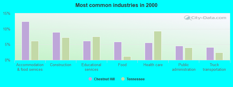
- Accommodation & food services (12.4%)
- Construction (8.9%)
- Educational services (6.2%)
- Food (5.9%)
- Health care (5.6%)
- Public administration (4.6%)
- Truck transportation (4.1%)
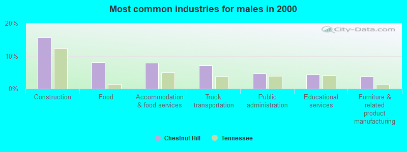
- Construction (15.7%)
- Food (8.0%)
- Accommodation & food services (7.9%)
- Truck transportation (7.2%)
- Public administration (4.6%)
- Educational services (4.3%)
- Furniture & related product manufacturing (3.7%)
- Accommodation & food services (18.2%)
- Health care (9.2%)
- Educational services (8.7%)
- Finance & insurance (5.2%)
- Food & beverage stores (5.2%)
- Social assistance (4.9%)
- Public administration (4.6%)
- Building and grounds cleaning and maintenance occupations (7.6%)
- Other sales and related occupations, including supervisors (6.1%)
- Other production occupations, including supervisors (5.6%)
- Driver/sales workers and truck drivers (4.7%)
- Electrical equipment mechanics and other installation, maintenance, and repair workers, including supervisors (4.0%)
- Construction traders workers except carpenters, electricians, painters, plumbers, and construction laborers (3.0%)
- Other management occupations, except farmers and farm managers (2.9%)
- Driver/sales workers and truck drivers (8.2%)
- Building and grounds cleaning and maintenance occupations (6.7%)
- Electrical equipment mechanics and other installation, maintenance, and repair workers, including supervisors (6.5%)
- Other sales and related occupations, including supervisors (6.5%)
- Other production occupations, including supervisors (6.1%)
- Construction traders workers except carpenters, electricians, painters, plumbers, and construction laborers (5.2%)
- Carpenters (4.5%)
- Building and grounds cleaning and maintenance occupations (8.7%)
- Preschool, kindergarten, elementary, and middle school teachers (5.7%)
- Other sales and related occupations, including supervisors (5.6%)
- Bookkeeping, accounting, and auditing clerks (5.3%)
- Other office and administrative support workers, including supervisors (5.2%)
- Secretaries and administrative assistants (4.9%)
- Nursing, psychiatric, and home health aides (4.9%)
Average climate in Chestnut Hill, Tennessee
Based on data reported by over 4,000 weather stations


(lower is better)
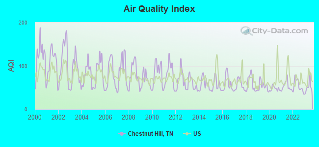
Air Quality Index (AQI) level in 2023 was 51.2. This is significantly better than average.
| City: | 51.2 |
| U.S.: | 72.6 |
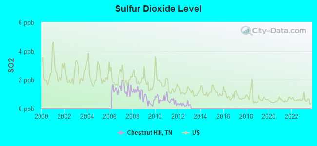
Sulfur Dioxide (SO2) [ppb] level in 2012 was 0.284. This is significantly better than average. Closest monitor was 20.3 miles away from the city center.
| City: | 0.284 |
| U.S.: | 1.515 |
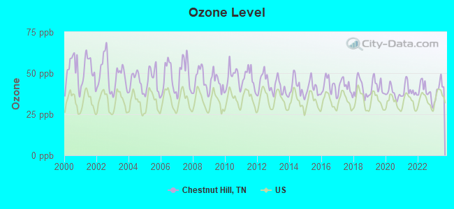
Ozone [ppb] level in 2023 was 40.5. This is worse than average. Closest monitor was 17.6 miles away from the city center.
| City: | 40.5 |
| U.S.: | 33.3 |
Tornado activity:
Chestnut Hill-area historical tornado activity is significantly below Tennessee state average. It is 55% smaller than the overall U.S. average.
On 2/21/1993, a category F3 (max. wind speeds 158-206 mph) tornado 35.2 miles away from the Chestnut Hill place center injured 3 people and caused between $500,000 and $5,000,000 in damages.
On 2/18/1976, a category F2 (max. wind speeds 113-157 mph) tornado 8.3 miles away from the place center injured 10 people and caused between $500,000 and $5,000,000 in damages.
Earthquake activity:
Chestnut Hill-area historical earthquake activity is significantly above Tennessee state average. It is 57% greater than the overall U.S. average.On 11/30/1973 at 07:48:41, a magnitude 4.7 (4.7 MB, 4.6 ML, Class: Light, Intensity: IV - V) earthquake occurred 34.9 miles away from the city center
On 8/9/2020 at 12:07:37, a magnitude 5.1 (5.1 MW, Depth: 4.7 mi, Class: Moderate, Intensity: VI - VII) earthquake occurred 132.0 miles away from the city center
On 7/27/1980 at 18:52:21, a magnitude 5.2 (5.1 MB, 4.7 MS, 5.0 UK, 5.2 UK) earthquake occurred 159.1 miles away from Chestnut Hill center
On 8/2/1974 at 08:52:09, a magnitude 4.9 (4.3 MB, 4.9 LG) earthquake occurred 152.2 miles away from the city center
On 8/23/2011 at 17:51:04, a magnitude 5.8 (5.8 MW, Depth: 3.7 mi) earthquake occurred 329.4 miles away from Chestnut Hill center
On 4/29/2003 at 08:59:39, a magnitude 4.9 (4.4 MB, 4.6 MW, 4.9 LG) earthquake occurred 162.7 miles away from Chestnut Hill center
Magnitude types: regional Lg-wave magnitude (LG), body-wave magnitude (MB), local magnitude (ML), surface-wave magnitude (MS), moment magnitude (MW)
Natural disasters:
The number of natural disasters in Jefferson County (15) is near the US average (15).Major Disasters (Presidential) Declared: 10
Emergencies Declared: 2
Causes of natural disasters: Floods: 10, Storms: 8, Tornadoes: 5, Heavy Rains: 2, Winds: 2, Winter Storms: 2, Flash Flood: 1, Hurricane: 1, Landslide: 1, Mudslide: 1, Snowfall: 1, Other: 1 (Note: some incidents may be assigned to more than one category).
Hospitals and medical centers near Chestnut Hill:
- JEFFERSON COUNTY NURSING HOME (Nursing Home, about 7 miles away; DANDRIDGE, TN)
- NEWPORT HEALTH AND REHABILITATION CENTER (Nursing Home, about 7 miles away; NEWPORT, TN)
- SMOKY MOUNTAIN HOME HEALTH AND HOSPICE, INC (Home Health Center, about 10 miles away; NEWPORT, TN)
- SMOKY MOUNTAIN HOSPICE INC (Hospital, about 10 miles away; NEWPORT, TN)
- FMC DIALYSIS NEWPORT (Dialysis Facility, about 10 miles away; NEWPORT, TN)
- VIP HOME NURSING REHAB SERVICE INC (Home Health Center, about 10 miles away; NEWPORT, TN)
- BAPTIST CONVALESCENT CENTER (Nursing Home, about 11 miles away; NEWPORT, TN)
Colleges/universities with over 2000 students nearest to Chestnut Hill:
- Walters State Community College (about 20 miles; Morristown, TN; Full-time enrollment: 4,359)
- The University of Tennessee-Knoxville (about 32 miles; Knoxville, TN; FT enrollment: 25,483)
- Tusculum College (about 38 miles; Greeneville, TN; FT enrollment: 2,070)
- Pellissippi State Community College (about 45 miles; Knoxville, TN; FT enrollment: 7,271)
- Lincoln Memorial University (about 47 miles; Harrogate, TN; FT enrollment: 3,706)
- Western Carolina University (about 49 miles; Cullowhee, NC; FT enrollment: 8,684)
- University of North Carolina at Asheville (about 51 miles; Asheville, NC; FT enrollment: 3,312)
Points of interest:
Notable locations in Chestnut Hill: Indian Creek Dock (A), Weaver Dock (B), Mountain View Dock (C), Swann Dock (D), French Broad (E), Inspiration Point Dock (F), Holly Oaks (G), Gator Point Campground (H), Fanchers Willow Branch Campground (I), Galloway Landing (J), Chestnut Hill Volunteer Fire Department (K). Display/hide their locations on the map
Churches in Chestnut Hill include: Eden Church (A), Lawson Chapel (B), Swannsylvania Church (C), Antioch Baptist Church (D), Ailey Chapel (E), Indian Creek Church (F), Hills Union Church (G), Parrot Church (H), Belmont Methodist Church (I). Display/hide their locations on the map
Cemeteries: Strange Cemetery (1), Swann Cemetery (2), Taylor Cemetery (3), Allen Cemetery (4), Ball Cemetery (5), Resthaven Memorial Gardens (6), Tryon Cemetery (7). Display/hide their locations on the map
Reservoir: Dalton Lake (A). Display/hide its location on the map
Streams, rivers, and creeks: Indian Creek (A), Hall Branch (B), Clear Creek (C), Chambers Branch (D), Muddy Hollow Branch (E), Miller Creek (F), Big Branch (G), Seehorn Creek (H), Slatey Branch (I). Display/hide their locations on the map
Park in Chestnut Hill: Dandridge Municipal Park (1). Display/hide its location on the map
| This place: | 2.4 people |
| Tennessee: | 2.5 people |
| This place: | 62.1% |
| Whole state: | 69.8% |
| This place: | 4.0% |
| Whole state: | 4.2% |
Likely homosexual households (counted as self-reported same-sex unmarried-partner households)
- Lesbian couples: 0.1% of all households
- Gay men: 0.3% of all households
| This place: | 13.2% |
| Whole state: | 13.5% |
| This place: | 5.3% |
| Whole state: | 5.8% |
For population 15 years and over in Chestnut Hill:
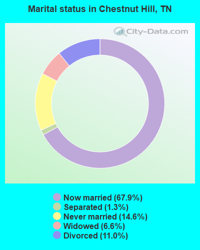
- Never married: 14.6%
- Now married: 67.9%
- Separated: 1.3%
- Widowed: 6.6%
- Divorced: 11.0%
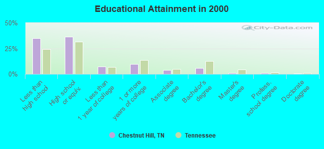
For population 25 years and over in Chestnut Hill:
- High school or higher: 65.2%
- Bachelor's degree or higher: 8.1%
- Graduate or professional degree: 2.2%
- Unemployed: 5.8%
- Mean travel time to work (commute): 31.6 minutes
| Here: | 12.5 |
| Tennessee average: | 13.3 |
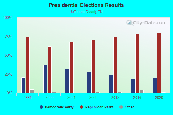
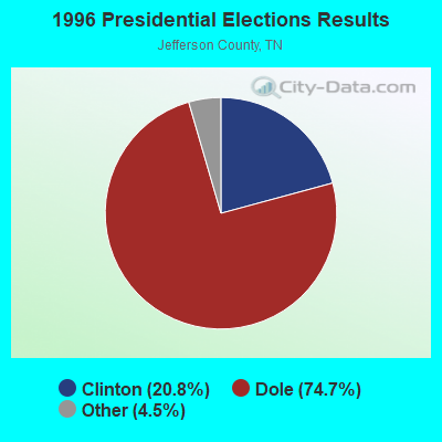
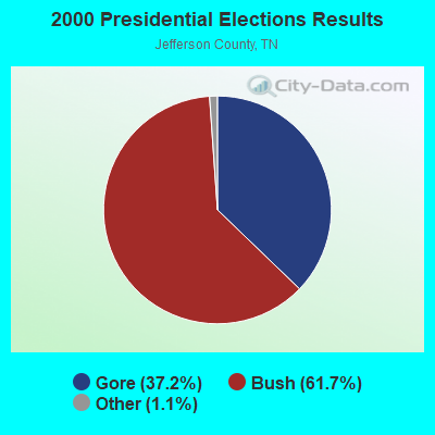
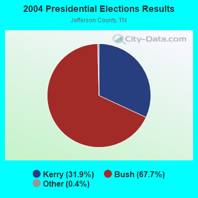
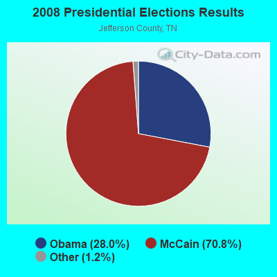
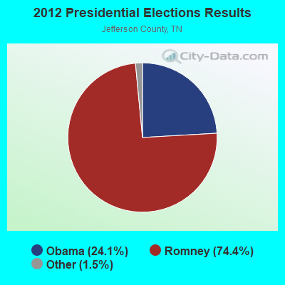
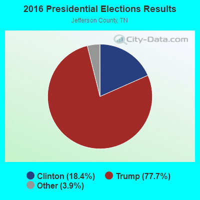
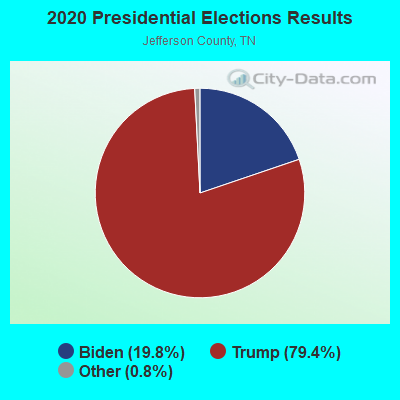
Graphs represent county-level data. Detailed 2008 Election Results
Religion statistics for Chestnut Hill, TN (based on Jefferson County data)
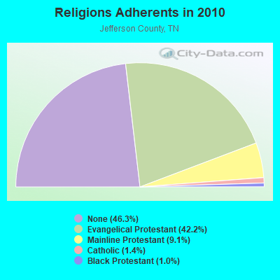

| Religion | Adherents | Congregations |
|---|---|---|
| Evangelical Protestant | 21,703 | 72 |
| Mainline Protestant | 4,675 | 33 |
| Catholic | 698 | 1 |
| Black Protestant | 505 | 4 |
| Other | 4 | 1 |
| None | 23,822 | - |
Food Environment Statistics:
| This county: | 1.00 / 10,000 pop. |
| Tennessee: | 1.99 / 10,000 pop. |
| This county: | 0.20 / 10,000 pop. |
| Tennessee: | 0.17 / 10,000 pop. |
| This county: | 0.40 / 10,000 pop. |
| State: | 0.65 / 10,000 pop. |
| Jefferson County: | 5.38 / 10,000 pop. |
| Tennessee: | 5.16 / 10,000 pop. |
| This county: | 4.79 / 10,000 pop. |
| State: | 6.56 / 10,000 pop. |
| Jefferson County: | 10.9% |
| Tennessee: | 11.4% |
| This county: | 28.8% |
| Tennessee: | 30.2% |
| Here: | 13.4% |
| Tennessee: | 13.5% |
Strongest AM radio stations in Chestnut Hill:
- WLIK (1270 AM; 5 kW; NEWPORT, TN; Owner: WLIK, INC)
- WKVL (850 AM; daytime; 50 kW; KNOXVILLE, TN; Owner: HORNE RADIO, LLC)
- WSEV (930 AM; 5 kW; SEVIERVILLE, TN; Owner: EAST TENNESSEE RADIO GROUP, L.P.)
- WVLZ (1180 AM; daytime; 10 kW; KNOXVILLE, TN; Owner: KIRKLAND WIRELESS BROADCASTERS, INC.)
- WFGW (1010 AM; 50 kW; BLACK MOUNTAIN, NC; Owner: BLUE RIDGE BROADCASTING CORP.)
- WMTN (1300 AM; 5 kW; MORRISTOWN, TN)
- WCRK (1150 AM; 5 kW; MORRISTOWN, TN; Owner: RADIO ACQUISITION CORP.)
- WNOX (990 AM; 10 kW; KNOXVILLE, TN)
- WRJZ (620 AM; 5 kW; KNOXVILLE, TN; Owner: TENNESSEE MEDIA ASSOCIATES, INC)
- WLFJ (660 AM; daytime; 50 kW; GREENVILLE, SC; Owner: CLEAR CHANNEL BROADCASTING LICENSES, INC.)
- WNPC (1060 AM; daytime; 1 kW; NEWPORT, TN; Owner: HARRIS BROADCASTING INCORPORATED)
- WKJV (1380 AM; 25 kW; ASHEVILLE, NC; Owner: INTERNATIONAL BAPTIST OUTREACH MISSIONS)
- WQBB (1040 AM; daytime; 10 kW; POWELL, TN; Owner: JOURNAL BROADCAST CORPORATION)
Strongest FM radio stations in Chestnut Hill:
- WNPC-FM (92.9 FM; NEWPORT, TN; Owner: HARRIS BROADCASTING INC DBA WNPC INC)
- WIVK-FM (107.7 FM; KNOXVILLE, TN; Owner: CITADEL BROADCASTING COMPANY)
- WWST (102.1 FM; SEVIERVILLE, TN; Owner: JOURNAL BROADCAST CORPORATION)
- WIMZ-FM (103.5 FM; KNOXVILLE, TN; Owner: SOUTH CENTRAL COMM., CORP.)
- W237AR (95.3 FM; HAZELWOOD, ETC., NC; Owner: WESTERN NORTH CAROLINA PUBLIC RADIO)
- WSEV-FM (105.5 FM; GATLINBURG, TN; Owner: EAST TENNESSEE RADIO GROUP, L.P.)
- WEZG (99.3 FM; JEFFERSON CITY, TN; Owner: EAST TENNESSEE RADIO GROUP, L.P.)
- WOKI-FM (100.3 FM; OAK RIDGE, TN; Owner: OAK RIDGE FM, INC.)
- WMXK (94.1 FM; MORRISTOWN, TN; Owner: HORNE RADIO, LLC)
- WUOT (91.9 FM; KNOXVILLE, TN; Owner: UNIVERSITY OF TENNESSEE)
- WKSF (99.9 FM; ASHEVILLE, NC; Owner: CAPSTAR TX LIMITED PARTNERSHIP)
- WJXB-FM (97.5 FM; KNOXVILLE, TN; Owner: SOUTH CENTRAL COMMUNICATIONS CORP.)
- WQNS (104.9 FM; WAYNESVILLE, NC; Owner: CLEAR CHANNEL BROADCASTING LICENSES, INC.)
- WBGQ (100.7 FM; BULLS GAP, TN; Owner: CHEROKEE BROADCASTING)
- WMIT (106.9 FM; BLACK MOUNTAIN, NC; Owner: BLUE RIDGE BROADCASTING CORPORATION)
- WNCW (88.7 FM; SPINDALE, NC; Owner: ISOTHERMAL COMMUNITY COLLEGE)
- WJDT (106.5 FM; ROGERSVILLE, TN; Owner: C & S BROADCASTING)
- W266AA (101.1 FM; KODAK, TN; Owner: SOUTH CENTRAL COMMUNICATIONS CORP.)
- WFQS (91.3 FM; FRANKLIN, NC; Owner: WESTERN NORTH CAROLINA PUBLIC RADIO)
- W220CD (91.9 FM; ENKA, NC; Owner: CALVARY CHAPEL OF TWIN FALLS, INC.)
TV broadcast stations around Chestnut Hill:
- WKOP-TV (Channel 15; KNOXVILLE, TN; Owner: EAST TENNESSEE PUBLIC COMMUNICATIONS CORP.)
- WBIR-TV (Channel 10; KNOXVILLE, TN; Owner: GANNETT PACIFIC CORPORATION)
- WVLT-TV (Channel 8; KNOXVILLE, TN; Owner: WVLT LICENSEE CORP.)
- WATE-TV (Channel 6; KNOXVILLE, TN; Owner: WATE, G.P.)
- WTNZ (Channel 43; KNOXVILLE, TN; Owner: RAYCOM AMERICA, INC.)
- WJZC-LP (Channel 22; SEVIERVILLE, TN; Owner: SOUTH CENTRAL COMMUNICATIONS CORP.)
- W50AB (Channel 50; HIAWASSEE, GA; Owner: GEORGIA PUBLIC TELECOMMUNICATIONS COMMISSION)
- WEEE-LP (Channel 32; KNOXVILLE, TN; Owner: TIGER EYE BROADCASTING CORPORATION)
- WASV-TV (Channel 62; ASHEVILLE, NC; Owner: MEDIA GENERAL BROADCASTING OF SOUTH CAROLINA HOLDINGS, INC.)
- WEZK-LP (Channel 28; KNOXVILLE, TN; Owner: SOUTH CENTRAL COMMUNICATIONS CORP.)
- WDTT-LP (Channel 38; LENOIR CITY, TN; Owner: WORD OF GOD FELLOWSHIP, INC.)
FCC Registered Antenna Towers:
24 (See the full list of FCC Registered Antenna Towers in Chestnut Hill)FCC Registered Broadcast Land Mobile Towers:
3- Chestnut Hill (Lat: 35.905361 Lon: -83.296556), Type: Tower, Structure height: 30 m, Call Sign: WNNC292,
Assigned Frequencies: 453.500 MHz, 453.175 MHz, Grant Date: 07/04/2023, Expiration Date: 07/15/2033, Certifier: Harry Watson, Registrant: U T Medical Center, 1924 Alcoa Highway, Knoxville, TN 37920, Phone: (865) 305-2580, Fax: (865) 305-9004, Email:
- Adjacent To English Mountain Fire Tower (Lat: 35.901472 Lon: -83.298222), Call Sign: KCZ402,
Assigned Frequencies: 151.595 MHz, Grant Date: 11/01/2023, Expiration Date: 10/27/2033, Registrant: Metro Communications LLC, 1210 Elm Street, Knoxville, TN 37921, Phone: (865) 546-0311, Fax: (865) 546-8666, Email:
- Adjacent To English Mountain Fire Tower (Lat: 35.901472 Lon: -83.298222), Call Sign: WDW331,
Assigned Frequencies: 452.100 MHz, Grant Date: 11/01/2023, Expiration Date: 10/27/2033, Registrant: Metro Communications LLC, 1210 Elm Street, Knoxville, TN 37921, Phone: (865) 546-0311, Fax: (865) 546-8666, Email:
FCC Registered Microwave Towers:
1- NA CHESTNUT, 9.8 Nm On 70.80 Degree Y Bearing To 14 (Lat: 35.910556 Lon: -83.329722), Type: Ltower, Structure height: 85.3 m, Overall height: 91.2 m, Call Sign: WQOV911,
Assigned Frequencies: 11245.0 MHz, 11325.0 MHz, Grant Date: 02/13/2012, Expiration Date: 02/13/2022, Cancellation Date: 02/09/2018, Certifier: Scott Hedspeth, Registrant: Conterra Ultra Broadband, LLC, 2101 Rexford Rd, Ste 200e, Charlotte, NC 28211, Phone: (704) 936-1801, Fax: (704) 936-1801, Email:
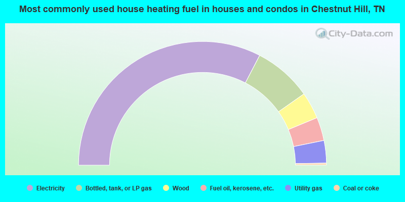
- 65.2%Electricity
- 15.2%Bottled, tank, or LP gas
- 7.0%Wood
- 6.1%Fuel oil, kerosene, etc.
- 5.9%Utility gas
- 0.5%Coal or coke
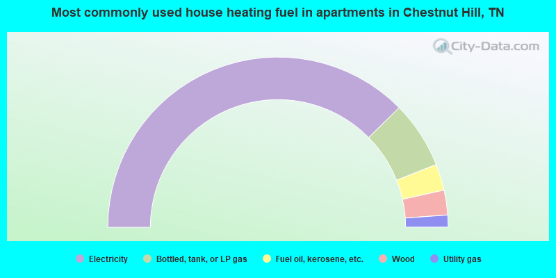
- 75.2%Electricity
- 12.8%Bottled, tank, or LP gas
- 5.0%Fuel oil, kerosene, etc.
- 4.7%Wood
- 2.3%Utility gas
Chestnut Hill compared to Tennessee state average:
- Unemployed percentage below state average.
- Black race population percentage significantly below state average.
- Hispanic race population percentage significantly below state average.
- Foreign-born population percentage significantly below state average.
- Renting percentage significantly below state average.
- Length of stay since moving in significantly above state average.
- Number of rooms per house significantly below state average.
- House age significantly below state average.
- Percentage of population with a bachelor's degree or higher significantly below state average.