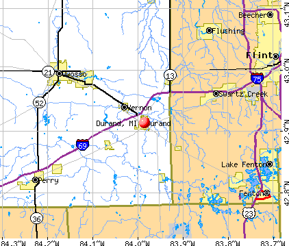
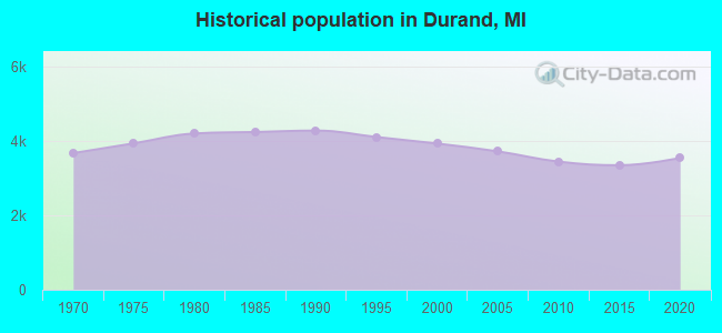
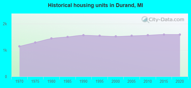
Durand, Michigan
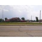
Durand: Durand Depot, a historical site in Durand
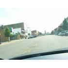
Durand: Saginaw St. Looking at the stores down town
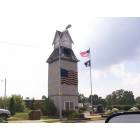
Durand: Clock tower in Durand

Durand: Sunflowers in a Durand country yard
- add
your
Submit your own pictures of this city and show them to the world
- OSM Map
- General Map
- Google Map
- MSN Map
Population change since 2000: -11.4%
 |
| Males: 1,536 | |
| Females: 1,947 |
| Median resident age: | 43.4 years |
| Michigan median age: | 40.3 years |
Zip codes: 48429.
| Durand: | $53,303 |
| MI: | $66,986 |
Estimated per capita income in 2022: $32,617 (it was $17,273 in 2000)
Durand city income, earnings, and wages data
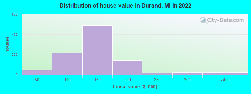
Estimated median house or condo value in 2022: $125,003 (it was $81,700 in 2000)
| Durand: | $125,003 |
| MI: | $224,400 |
Mean prices in 2022: all housing units: $120,587; detached houses: $121,068
Median gross rent in 2022: $839.
(13.9% for White Non-Hispanic residents, 16.7% for two or more races residents)
Detailed information about poverty and poor residents in Durand, MI
Compare current foreclosures near Durand, MI:
| Photo | Address | Area | Beds / Baths | Price | Details |
|---|---|---|---|---|---|

|
#1
E Genesee St
Durand, MI 48429
|
- sq. feet
|
1 baths 3 beds |
$47,500
|
show details |

|
#2
W Elm St
Durand, MI 48429
|
1,231 sq. feet
|
1 baths 4 beds |
show details | |

|
#3
E M 71
Durand, MI 48429
|
1,100 sq. feet
|
1 baths 3 beds |
show details | |

|
#4
E Naldrette St
Durand, MI 48429
|
- sq. feet
|
- baths - beds |
show details | |

|
#5
E Genesee St
Durand, MI 48429
|
- sq. feet
|
- baths - beds |
show details | |

|
#6
N Oak St Apt 603
Durand, MI 48429
|
- sq. feet
|
- baths - beds |
show details | |

|
#7
W Genesee St
Durand, MI 48429
|
- sq. feet
|
- baths - beds |
show details | |

|
#8
W Dewey St
Flint, MI 48505
|
1,440 sq. feet
|
1 baths 3 beds |
$120,500
|
show details |

|
#9
Covered Wagons Trl
Flint, MI 48532
|
4,108 sq. feet
|
4 baths 4 beds |
$499,500
|
show details |

|
#10
E Bennington Rd
Durand, MI 48429
|
- sq. feet
|
- baths - beds |
show details |
| Photo | Address | Area | Beds / Baths | Price | Details |
|---|---|---|---|---|---|

|
#11
E Newburg Rd
Durand, MI 48429
|
- sq. feet
|
- baths - beds |
show details | |

|
#12
W Reid Rd
Durand, MI 48429
|
- sq. feet
|
- baths - beds |
show details | |

|
#13
S Maple St
Durand, MI 48429
|
- sq. feet
|
- baths - beds |
show details | |

|
#14
E Vinewood St
Durand, MI 48429
|
- sq. feet
|
- baths - beds |
show details | |

|
#15
N Marquette St
Durand, MI 48429
|
- sq. feet
|
- baths - beds |
show details | |

|
#16
E Cole Rd
Durand, MI 48429
|
- sq. feet
|
- baths - beds |
show details | |

|
#17
N Fitch St
Durand, MI 48429
|
- sq. feet
|
- baths - beds |
show details | |

|
#18
Garrison Rd
Durand, MI 48429
|
- sq. feet
|
- baths - beds |
show details | |

|
#19
Crapo St
Swartz Creek, MI 48473
|
696 sq. feet
|
1 baths 2 beds |
show details | |

|
#20
Valley Oaks Cir # 20
Flint, MI 48532
|
1,280 sq. feet
|
3 baths 2 beds |
show details |
| Photo | Address | Area | Beds / Baths | Price | Details |
|---|---|---|---|---|---|

|
#21
E Julie Ct
Byron, MI 48418
|
1,303 sq. feet
|
2 baths 3 beds |
show details | |

|
#22
N Jennings Rd
Flint, MI 48504
|
2,018 sq. feet
|
1 baths 4 beds |
show details | |

|
#23
Johnson Rd
Flushing, MI 48433
|
1,986 sq. feet
|
2 baths 4 beds |
show details | |

|
#24
Dollar Lake Dr
Fenton, MI 48430
|
1,800 sq. feet
|
1 baths 2 beds |
show details | |

|
#25
Brady Ave
Burton, MI 48529
|
1,400 sq. feet
|
2 baths 4 beds |
show details | |

|
#26
Division Rd
Owosso, MI 48867
|
1,008 sq. feet
|
1 baths 1 beds |
show details | |

|
#27
Young St
Owosso, MI 48867
|
1,059 sq. feet
|
1 baths 3 beds |
show details | |

|
#28
Partridge Dr
Flushing, MI 48433
|
1,528 sq. feet
|
1 baths 4 beds |
show details | |

|
#29
Beers Rd
Swartz Creek, MI 48473
|
1,424 sq. feet
|
2 baths 4 beds |
show details | |

|
#30
Wolcott St
Flint, MI 48504
|
700 sq. feet
|
1 baths 2 beds |
show details |
| Photo | Address | Area | Beds / Baths | Price | Details |
|---|---|---|---|---|---|

|
#31
S M-52
Owosso, MI 48867
|
1,988 sq. feet
|
2 baths 4 beds |
show details | |

|
#32
Woodside Cir
Grand Blanc, MI 48439
|
984 sq. feet
|
1 baths 2 beds |
show details | |

|
#33
Cook Rd
Swartz Creek, MI 48473
|
1,120 sq. feet
|
1 baths 3 beds |
show details | |

|
#34
Stockton St
Flint, MI 48503
|
1,880 sq. feet
|
3 baths 3 beds |
show details | |

|
#35
Stevenson St
Flint, MI 48504
|
942 sq. feet
|
1 baths 3 beds |
show details | |

|
#36
N Mckinley Rd
Flushing, MI 48433
|
1,840 sq. feet
|
1 baths 4 beds |
show details | |

|
#37
Begole St
Flint, MI 48504
|
894 sq. feet
|
1 baths 2 beds |
show details | |

|
#38
Fenton Rd
Flint, MI 48507
|
- sq. feet
|
2 baths 3 beds |
show details | |

|
#39
Zimmerman St
Flint, MI 48503
|
1,176 sq. feet
|
1 baths 4 beds |
show details | |

|
#40
Clinton St
Flint, MI 48507
|
1,475 sq. feet
|
1 baths 3 beds |
show details |
| Photo | Address | Area | Beds / Baths | Price | Details |
|---|---|---|---|---|---|

|
#41
Brownell Blvd
Flint, MI 48504
|
1,263 sq. feet
|
1 baths 3 beds |
show details | |

|
#42
Litchfield Dr
Flint, MI 48532
|
1,264 sq. feet
|
1 baths 3 beds |
show details | |

|
#43
Moulton Dr
Flint, MI 48507
|
1,276 sq. feet
|
1 baths 3 beds |
show details | |

|
#44
W Pasadena Ave
Flint, MI 48504
|
1,020 sq. feet
|
1 baths 3 beds |
show details | |

|
#45
S Corey Rd
Perry, MI 48872
|
1,008 sq. feet
|
1 baths 3 beds |
show details | |

|
#46
Carpenter Rd
Flushing, MI 48433
|
2,021 sq. feet
|
2 baths 4 beds |
show details | |

|
#47
S M 52
Perry, MI 48872
|
1,201 sq. feet
|
1 baths 3 beds |
show details | |

|
#48
Van Vleet Rd
Gaines, MI 48436
|
2,340 sq. feet
|
1 baths 3 beds |
show details | |

|
#49
Prospect Dr
Byron, MI 48418
|
1,560 sq. feet
|
2 baths 3 beds |
show details | |

|
Check over 1 million property listings on Foreclosure.com!
|
browse all offers | |||


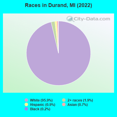
- 3,34595.9%White alone
- 661.9%Two or more races
- 310.9%Hispanic
- 250.7%Asian alone
- 80.2%Black alone
Races in Durand detailed stats: ancestries, foreign born residents, place of birth
According to our research of Michigan and other state lists, there were 38 registered sex offenders living in Durand, Michigan as of April 27, 2024.
The ratio of all residents to sex offenders in Durand is 88 to 1.
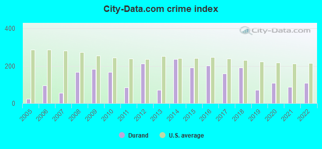
Type |
2009 |
2010 |
2011 |
2012 |
2013 |
2014 |
2015 |
2016 |
2017 |
2018 |
2019 |
2020 |
2021 |
2022 |
|---|---|---|---|---|---|---|---|---|---|---|---|---|---|---|
| Murders (per 100,000) | 0 (0.0) | 0 (0.0) | 0 (0.0) | 0 (0.0) | 0 (0.0) | 0 (0.0) | 0 (0.0) | 0 (0.0) | 0 (0.0) | 0 (0.0) | 0 (0.0) | 0 (0.0) | 0 (0.0) | 0 (0.0) |
| Rapes (per 100,000) | 3 (80.7) | 2 (58.0) | 2 (58.1) | 6 (176.0) | 1 (29.9) | 7 (209.5) | 3 (90.0) | 3 (90.4) | 3 (90.6) | 3 (91.0) | 1 (26.1) | 1 (26.2) | 2 (52.7) | 1 (24.8) |
| Robberies (per 100,000) | 0 (0.0) | 0 (0.0) | 0 (0.0) | 0 (0.0) | 0 (0.0) | 0 (0.0) | 1 (30.0) | 1 (30.1) | 0 (0.0) | 0 (0.0) | 2 (52.3) | 1 (26.2) | 0 (0.0) | 0 (0.0) |
| Assaults (per 100,000) | 2 (53.8) | 5 (145.1) | 6 (174.3) | 5 (146.6) | 3 (89.6) | 0 (0.0) | 7 (210.0) | 10 (301.5) | 5 (151.0) | 6 (182.0) | 3 (78.4) | 10 (261.9) | 3 (79.1) | 7 (173.6) |
| Burglaries (per 100,000) | 21 (564.8) | 8 (232.2) | 0 (0.0) | 5 (146.6) | 2 (59.7) | 9 (269.4) | 5 (150.0) | 8 (241.2) | 5 (151.0) | 6 (182.0) | 1 (26.1) | 0 (0.0) | 0 (0.0) | 5 (124.0) |
| Thefts (per 100,000) | 59 (1,587) | 64 (1,857) | 3 (87.1) | 24 (703.8) | 10 (298.5) | 36 (1,078) | 45 (1,350) | 35 (1,055) | 35 (1,057) | 43 (1,305) | 14 (366.0) | 21 (550.0) | 20 (527.4) | 40 (991.8) |
| Auto thefts (per 100,000) | 2 (53.8) | 1 (29.0) | 0 (0.0) | 2 (58.7) | 6 (179.1) | 3 (89.8) | 2 (60.0) | 1 (30.1) | 2 (60.4) | 7 (212.4) | 2 (52.3) | 3 (78.6) | 4 (105.5) | 3 (74.4) |
| Arson (per 100,000) | 0 (0.0) | 1 (29.0) | 0 (0.0) | 1 (29.3) | 0 (0.0) | 1 (29.9) | 0 (0.0) | 0 (0.0) | 0 (0.0) | 1 (30.3) | 0 (0.0) | 0 (0.0) | 0 (0.0) | 0 (0.0) |
| City-Data.com crime index | 182.6 | 168.3 | 84.8 | 213.2 | 72.2 | 236.8 | 192.3 | 203.2 | 160.3 | 191.1 | 72.9 | 109.5 | 87.6 | 108.9 |
The City-Data.com crime index weighs serious crimes and violent crimes more heavily. Higher means more crime, U.S. average is 246.1. It adjusts for the number of visitors and daily workers commuting into cities.
Crime rate in Durand detailed stats: murders, rapes, robberies, assaults, burglaries, thefts, arson
Full-time law enforcement employees in 2021, including police officers: 5 (5 officers - 5 male; 0 female).
| Officers per 1,000 residents here: | 1.32 |
| Michigan average: | 1.86 |
 Recent articles from our blog. Our writers, many of them Ph.D. graduates or candidates, create easy-to-read articles on a wide variety of topics.

 | Ann Arbor - Traverse City (and Petoskey, too!) train (14 replies) |
| Where do you consider that "Northern Michigan" begins? (63 replies) |
| Top city's in MI (36 replies) |
| Looking to possibly move to Owosso / Corunna (2 replies) |
| Living on the Water, Reasonable Areas? (4 replies) |
| Why is Lapeer so run down? Any chance Lapeer-Metamora see a housing boom? (17 replies) |
Latest news from Durand, MI collected exclusively by city-data.com from local newspapers, TV, and radio stations
Ancestries: English (17.3%), German (12.7%), Irish (11.6%), American (11.2%), European (6.8%), Hungarian (5.6%).
Current Local Time: EST time zone
Elevation: 796 feet
Land area: 1.97 square miles.
Population density: 1,771 people per square mile (low).
19 residents are foreign born
| This city: | 0.5% |
| Michigan: | 6.9% |
Median real estate property taxes paid for housing units with mortgages in 2022: $2,124 (1.7%)
Median real estate property taxes paid for housing units with no mortgage in 2022: $1,863 (1.4%)
Nearest city with pop. 50,000+: Flint, MI  (16.7 miles , pop. 124,943).
Nearest city with pop. 200,000+: Detroit, MI (57.8 miles , pop. 951,270).
Nearest city with pop. 1,000,000+: Chicago, IL (202.8 miles , pop. 2,896,016).
Nearest cities:
), ), ), ), ), )Latitude: 42.91 N, Longitude: 83.99 W
Area code: 989
Durand, Michigan accommodation & food services, waste management - Economy and Business Data
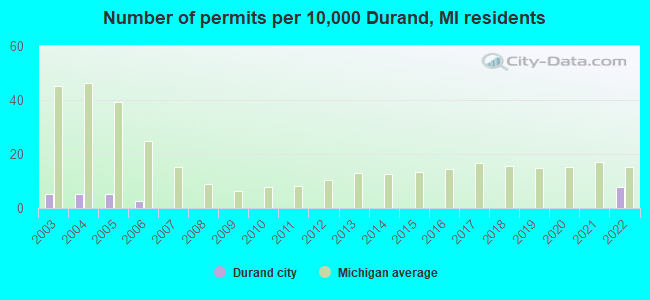
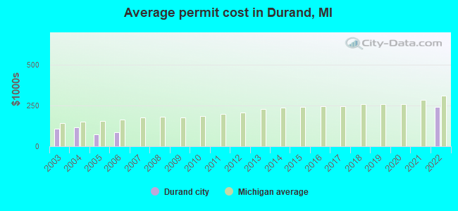
Single-family new house construction building permits:
- 2022: 3 buildings, average cost: $239,800
- 2006: 1 building, cost: $85,000
- 2005: 2 buildings, average cost: $75,300
- 2004: 2 buildings, average cost: $118,200
- 2003: 2 buildings, average cost: $109,000
| Here: | 3.9% |
| Michigan: | 3.5% |

- Transportation equipment (13.8%)
- Educational services (7.8%)
- Accommodation & food services (7.4%)
- Health care (7.2%)
- Metal & metal products (6.6%)
- Food & beverage stores (5.5%)
- Construction (4.6%)
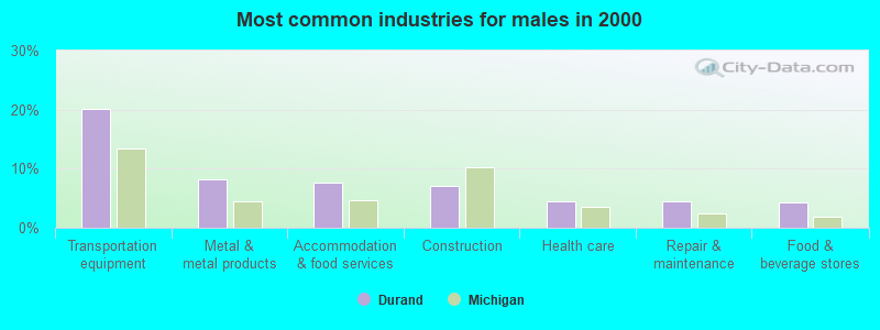
- Transportation equipment (20.2%)
- Metal & metal products (8.1%)
- Accommodation & food services (7.6%)
- Construction (7.1%)
- Health care (4.5%)
- Repair & maintenance (4.5%)
- Food & beverage stores (4.2%)
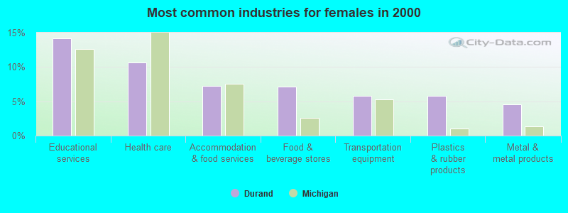
- Educational services (14.2%)
- Health care (10.6%)
- Accommodation & food services (7.2%)
- Food & beverage stores (7.1%)
- Transportation equipment (5.8%)
- Plastics & rubber products (5.8%)
- Metal & metal products (4.6%)
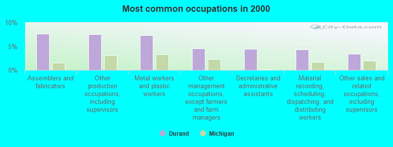
- Assemblers and fabricators (7.7%)
- Other production occupations, including supervisors (7.5%)
- Metal workers and plastic workers (7.3%)
- Other management occupations, except farmers and farm managers (4.5%)
- Secretaries and administrative assistants (4.4%)
- Material recording, scheduling, dispatching, and distributing workers (4.3%)
- Other sales and related occupations, including supervisors (3.4%)
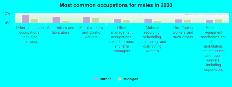
- Other production occupations, including supervisors (10.3%)
- Assemblers and fabricators (7.8%)
- Metal workers and plastic workers (7.5%)
- Other management occupations, except farmers and farm managers (5.6%)
- Material recording, scheduling, dispatching, and distributing workers (5.1%)
- Driver/sales workers and truck drivers (4.7%)
- Electrical equipment mechanics and other installation, maintenance, and repair workers, including supervisors (3.9%)

- Secretaries and administrative assistants (10.0%)
- Assemblers and fabricators (7.5%)
- Metal workers and plastic workers (7.0%)
- Cashiers (6.2%)
- Other sales and related occupations, including supervisors (4.3%)
- Other production occupations, including supervisors (3.9%)
- Preschool, kindergarten, elementary, and middle school teachers (3.8%)
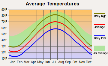
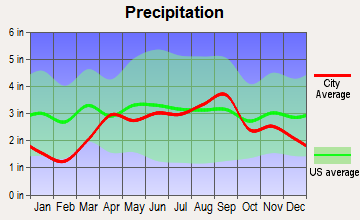
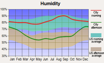
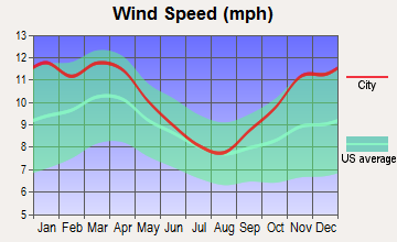
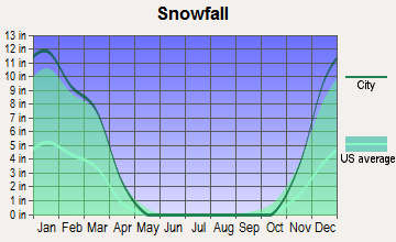
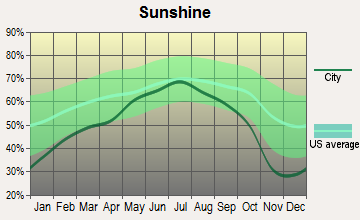
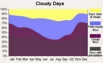
Average climate in Durand, Michigan
Based on data reported by over 4,000 weather stations
(lower is better)
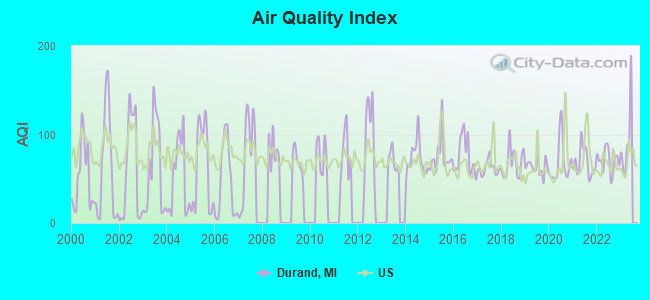
Air Quality Index (AQI) level in 2022 was 70.9. This is about average.
| City: | 70.9 |
| U.S.: | 72.6 |
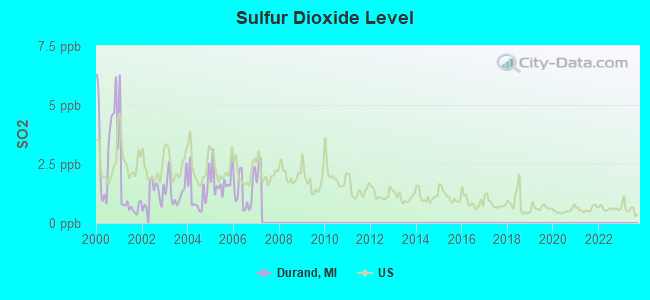
Sulfur Dioxide (SO2) [ppb] level in 2006 was 1.34. This is about average. Closest monitor was 15.1 miles away from the city center.
| City: | 1.34 |
| U.S.: | 1.51 |
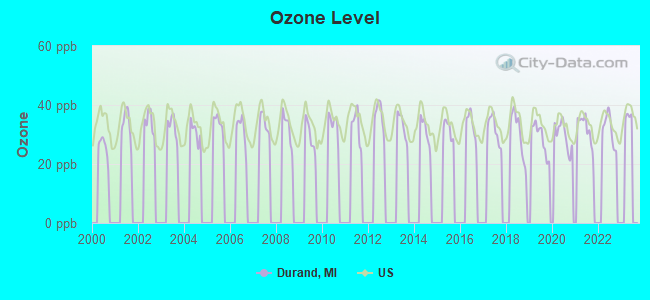
Ozone [ppb] level in 2022 was 31.7. This is about average. Closest monitor was 17.0 miles away from the city center.
| City: | 31.7 |
| U.S.: | 33.3 |
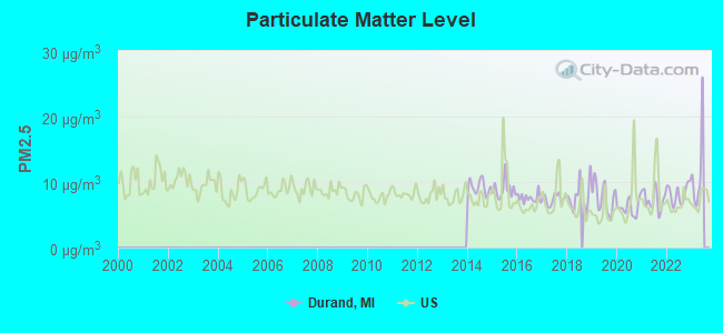
Particulate Matter (PM2.5) [µg/m3] level in 2022 was 8.25. This is about average. Closest monitor was 18.4 miles away from the city center.
| City: | 8.25 |
| U.S.: | 8.11 |
Tornado activity:
Durand-area historical tornado activity is above Michigan state average. It is 62% greater than the overall U.S. average.
On 6/8/1953, a category F5 (max. wind speeds 261-318 mph) tornado 14.6 miles away from the Durand city center killed 116 people and injured 844 people and caused between $5,000,000 and $50,000,000 in damages.
On 4/11/1965, a category F4 (max. wind speeds 207-260 mph) tornado 12.4 miles away from the city center killed one person and injured 8 people and caused between $50,000 and $500,000 in damages.
Earthquake activity:
Durand-area historical earthquake activity is significantly above Michigan state average. It is 45% smaller than the overall U.S. average.On 9/25/1998 at 19:52:52, a magnitude 5.2 (4.8 MB, 4.3 MS, 5.2 LG, 4.5 MW, Depth: 3.1 mi, Class: Moderate, Intensity: VI - VII) earthquake occurred 208.6 miles away from Durand center
On 1/31/1986 at 16:46:43, a magnitude 5.0 (5.0 MB) earthquake occurred 170.7 miles away from the city center
On 5/2/2015 at 16:23:07, a magnitude 4.2 (4.2 MW, Depth: 2.8 mi, Class: Light, Intensity: IV - V) earthquake occurred 87.2 miles away from Durand center
On 7/12/1986 at 08:19:37, a magnitude 4.5 (4.5 MB) earthquake occurred 165.6 miles away from the city center
On 7/27/1980 at 18:52:21, a magnitude 5.2 (5.1 MB, 4.7 MS, 5.0 UK, 5.2 UK) earthquake occurred 325.7 miles away from Durand center
On 4/18/2008 at 09:36:59, a magnitude 5.4 (5.1 MB, 4.8 MS, 5.4 MW, 5.2 MW) earthquake occurred 370.2 miles away from Durand center
Magnitude types: regional Lg-wave magnitude (LG), body-wave magnitude (MB), surface-wave magnitude (MS), moment magnitude (MW)
Natural disasters:
The number of natural disasters in Shiawassee County (13) is near the US average (15).Major Disasters (Presidential) Declared: 8
Emergencies Declared: 4
Causes of natural disasters: Storms: 8, Floods: 6, Tornadoes: 3, Winds: 3, Snowstorms: 2, Blizzard: 1, Hurricane: 1, Winter Storm: 1, Other: 1 (Note: some incidents may be assigned to more than one category).
Hospitals and medical centers in Durand:
Other hospitals and medical centers near Durand:
- SHIAWASSEE COUNTY MED CARE FAC (Nursing Home, about 9 miles away; CORUNNA, MI)
- FMC DIALYSIS - OWOSSO (Dialysis Facility, about 11 miles away; OWOSSO, MI)
- ARGENTINE CARE CENTER (Nursing Home, about 12 miles away; LINDEN, MI)
- SURGERY CENTER OF GENESEE COUNTY (Hospital, about 12 miles away; FLINT, MI)
- MEMORIAL HEALTHCARE Acute Care Hospitals (about 12 miles away; OWOSSO, MI)
- GENTIVA HEALTH SERVICES (Home Health Center, about 13 miles away; FLINT, MI)
- FMC DIALYSIS - FLINT (Dialysis Facility, about 13 miles away; FLINT, MI)
Airports located in Durand:
- Waite Field Airport (29M) (Runways: 1, Itinerant Ops: 50, Local Ops: 50)
Colleges/universities with over 2000 students nearest to Durand:
- Baker College of Owosso (about 11 miles; Owosso, MI; Full-time enrollment: 2,081)
- Baker College of Flint (about 16 miles; Flint, MI; FT enrollment: 3,877)
- Baker College Center for Graduate Studies (about 16 miles; Flint, MI; FT enrollment: 3,405)
- Kettering University (about 16 miles; Flint, MI; FT enrollment: 2,044)
- University of Michigan-Flint (about 17 miles; Flint, MI; FT enrollment: 6,284)
- Mott Community College (about 18 miles; Flint, MI; FT enrollment: 7,394)
- Michigan State University (about 29 miles; East Lansing, MI; FT enrollment: 41,736)
Public high school in Durand:
- DURAND AREA HIGH SCHOOL (Students: 627, Location: 9575 EAST MONROE RD, Grades: 8-12)
Public elementary/middle schools in Durand:
- DURAND MIDDLE SCHOOL (Students: 453, Location: 9550 EAST LANSING RD, Grades: 5-7)
- ROBERT KERR SCHOOL (Students: 229, Location: 9591 EAST MONROE RD, Grades: 2-4)
- BERTHA NEAL SCHOOL (Students: 228, Location: 930 WEST MAIN ST, Grades: PK-1)
Points of interest:
Notable locations in Durand: Durand Station (A), Monroe Plaza (B), Michigan History Railroad Museum (C), Durand Memorial Library (D), Durand Fire Department (E), Durand City Hall (F), Durand Vernon Ambulance (G). Display/hide their locations on the map
Churches in Durand include: First Baptist Church (A), Oak Street Baptist Church (B), Free Methodist Church (C), Light of Faith Fellowship (D), Faith Baptist Church (E), Durand Assembly of God Church (F), Congregational Church (G), Saint Mary's Church (H). Display/hide their locations on the map
Parks in Durand include: Optimist Park (1), Shaw Park (2), Trumble Park (3), Durand Railroad History Historical Marker (4), Knights Templar Special Historical Marker (5), Durand Union Station Historical Marker (6). Display/hide their locations on the map
Tourist attractions: Durand Union Station Inc (Cultural Attractions- Events- & Facilities; 200 South Railroad Street), Durand Amusement CO (Amusement & Theme Parks; 208 North Saginaw Street).
Birthplace of: Clare Fischer - Keyboardist, Stewart "Dirk" Fischer - Composer.
Drinking water stations with addresses in Durand and their reported violations in the past:
DURAND, CITY OF (Population served: 3,933, Groundwater):Past health violations:LEISURE LAKE CONDO ASSN. (Population served: 425, Groundwater):Past monitoring violations:
- MCL, Monthly (TCR) - In AUG-2013, Contaminant: Coliform. Follow-up actions: St Public Notif requested (AUG-23-2013), St Violation/Reminder Notice (AUG-23-2013), St Compliance achieved (SEP-30-2013), St Public Notif received (FEB-16-2014)
- One regular monitoring violation
Past health violations:HOLIDAY SHORES CAMPGROUND (Population served: 400, Groundwater):Past monitoring violations:
- MCL, Monthly (TCR) - In JUL-2012, Contaminant: Coliform. Follow-up actions: St Compliance achieved (AUG-29-2012)
- MCL, Monthly (TCR) - In JUL-2011, Contaminant: Coliform. Follow-up actions: St Compliance achieved (SEP-07-2011)
- MCL, Monthly (TCR) - In JUL-2007, Contaminant: Coliform. Follow-up actions: St Violation/Reminder Notice (JUL-25-2007), St Compliance achieved (AUG-15-2007)
- 2 routine major monitoring violations
Past monitoring violations:WALNUT HILLS CAMPGROUND (Population served: 165, Groundwater):
- 5 routine major monitoring violations
Past monitoring violations:WALNUT HILLS CAMPGROUND (Population served: 164, Groundwater):
- One routine major monitoring violation
- One regular monitoring violation
Past monitoring violations:WALNUT HILLS CAMPGROUND #3 (Population served: 160, Groundwater):
- One routine major monitoring violation
- One regular monitoring violation
Past monitoring violations:COUNTRY MANOR (Population served: 87, Groundwater):
- One routine major monitoring violation
- One regular monitoring violation
Past health violations:LEISURE LAKE SNACK BAR (Population served: 25, Groundwater):
- MCL, Average - Between JAN-23-2006 and MAR-01-2007, Contaminant: Arsenic. Follow-up actions: St AO (w/o penalty) issued (DEC-02-2005), St Violation/Reminder Notice (FEB-02-2006), St Public Notif requested (FEB-02-2006), St Public Notif received (4 times from FEB-21-2006 to DEC-26-2006), St Compliance achieved (MAR-01-2007)
Past monitoring violations:
- One routine major monitoring violation
Drinking water stations with addresses in Durand that have no violations reported:
- REED-RAYMOND VFW POST #2272 (Population served: 500, Primary Water Source Type: Groundwater)
- SAGE LINK CREDIT UNION (Population served: 25, Primary Water Source Type: Groundwater)
| This city: | 2.5 people |
| Michigan: | 2.5 people |
| This city: | 63.1% |
| Whole state: | 66.0% |
| This city: | 8.7% |
| Whole state: | 6.4% |
Likely homosexual households (counted as self-reported same-sex unmarried-partner households)
- Lesbian couples: 0.4% of all households
- Gay men: 0.1% of all households
156 people in nursing homes in 2000
Banks with branches in Durand (2011 data):
- Citizens Bank: Durand Branch at 201 North Saginaw Street, branch established on 1958/07/01; Durand Drive-In Branch at 300 North Saginaw Street, branch established on 1972/11/22. Info updated 2011/08/01: Bank assets: $9,212.3 mil, Deposits: $7,452.0 mil, headquarters in Flint, MI, positive income, Commercial Lending Specialization, 220 total offices, Holding Company: Citizens Republic Bancorp, Inc.
- Fifth Third Bank: Durand Branch at 5300 South Durand Road, branch established on 1971/11/16. Info updated 2009/10/05: Bank assets: $114,540.4 mil, Deposits: $89,689.1 mil, headquarters in Cincinnati, OH, positive income, Commercial Lending Specialization, 1378 total offices, Holding Company: Fifth Third Bancorp
- RBS Citizens, National Association: Durand at 210 North Saginaw Street, branch established on 1934/05/01. Info updated 2007/09/19: Bank assets: $106,940.6 mil, Deposits: $75,690.2 mil, headquarters in Providence, RI, positive income, 1135 total offices, Holding Company: Uk Financial Investments Limited
For population 15 years and over in Durand:
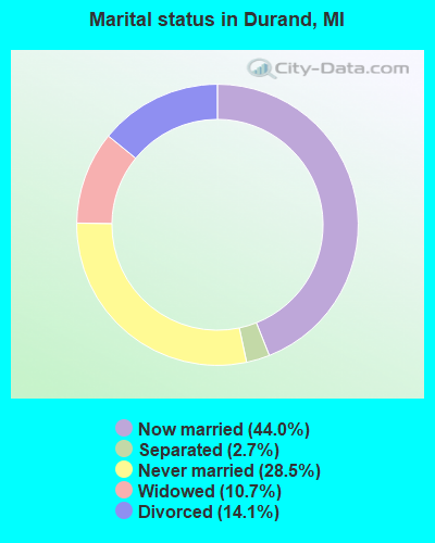
- Never married: 28.5%
- Now married: 44.0%
- Separated: 2.7%
- Widowed: 10.7%
- Divorced: 14.1%
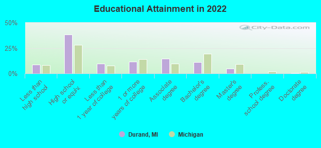
For population 25 years and over in Durand:
- High school or higher: 91.7%
- Bachelor's degree or higher: 15.5%
- Graduate or professional degree: 4.2%
- Unemployed: 5.4%
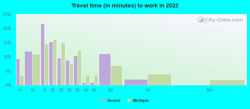
- Mean travel time to work (commute): 24.6 minutes
| Here: | 9.2 |
| Michigan average: | 11.0 |
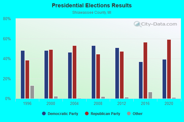
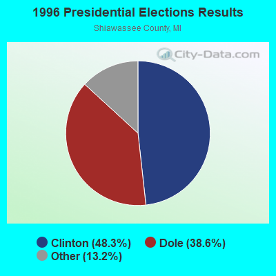
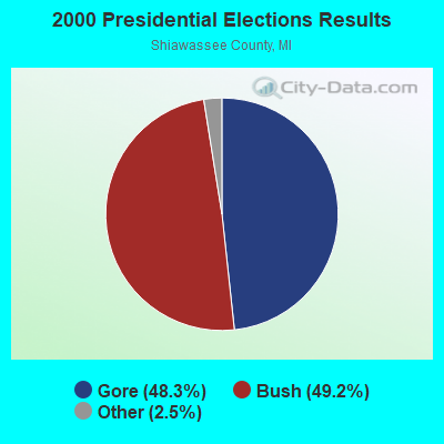
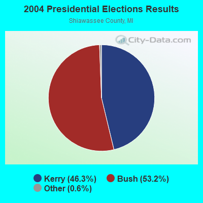
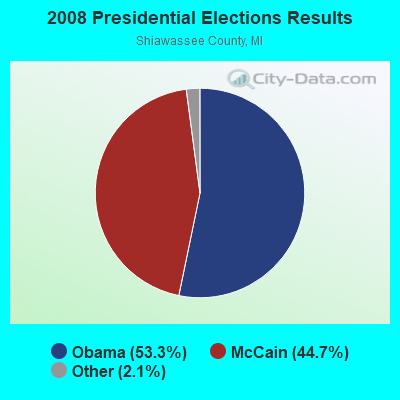
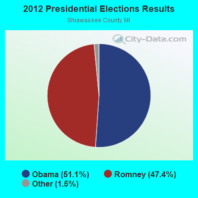
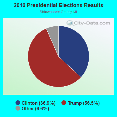
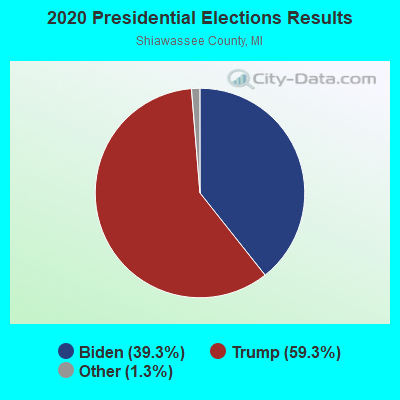
Graphs represent county-level data. Detailed 2008 Election Results
Religion statistics for Durand, MI (based on Shiawassee County data)
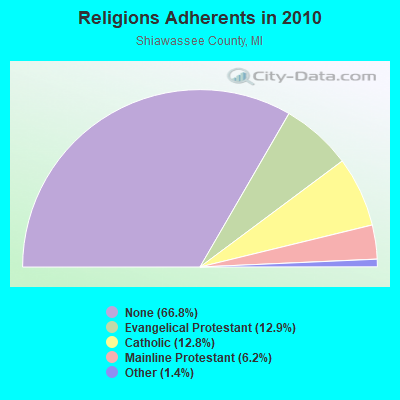
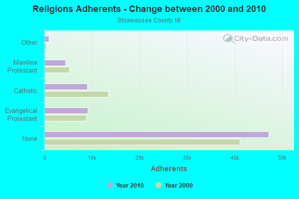
| Religion | Adherents | Congregations |
|---|---|---|
| Evangelical Protestant | 9,140 | 57 |
| Catholic | 9,009 | 5 |
| Mainline Protestant | 4,351 | 29 |
| Other | 958 | 8 |
| None | 47,190 | - |
Food Environment Statistics:
| Shiawassee County: | 1.53 / 10,000 pop. |
| Michigan: | 2.34 / 10,000 pop. |
| This county: | 0.14 / 10,000 pop. |
| Michigan: | 0.18 / 10,000 pop. |
| Shiawassee County: | 1.67 / 10,000 pop. |
| Michigan: | 1.52 / 10,000 pop. |
| Here: | 2.93 / 10,000 pop. |
| Michigan: | 2.99 / 10,000 pop. |
| Shiawassee County: | 5.44 / 10,000 pop. |
| Michigan: | 6.80 / 10,000 pop. |
| Shiawassee County: | 8.8% |
| State: | 9.7% |
| This county: | 28.8% |
| Michigan: | 29.7% |
| This county: | 14.4% |
| Michigan: | 13.4% |
Health and Nutrition:
| This city: | 48.8% |
| Michigan: | 50.3% |
| Durand: | 45.6% |
| Michigan: | 47.9% |
| Here: | 28.7 |
| Michigan: | 28.7 |
| Durand: | 21.7% |
| Michigan: | 20.6% |
| Here: | 6.6% |
| Michigan: | 10.4% |
| Here: | 6.8 |
| State: | 6.8 |
| Durand: | 30.0% |
| Michigan: | 34.1% |
| This city: | 58.2% |
| Michigan: | 57.0% |
| Here: | 77.3% |
| Michigan: | 79.6% |
More about Health and Nutrition of Durand, MI Residents
| Local government employment and payroll (March 2022) | |||||
| Function | Full-time employees | Monthly full-time payroll | Average yearly full-time wage | Part-time employees | Monthly part-time payroll |
|---|---|---|---|---|---|
| Other and Unallocable | 6 | $43,515 | $87,030 | 1 | $1,382 |
| Police Protection - Officers | 5 | $28,575 | $68,580 | 2 | $3,786 |
| Other Government Administration | 4 | $16,574 | $49,722 | 0 | $0 |
| Water Supply | 2 | $7,498 | $44,988 | 0 | $0 |
| Financial Administration | 2 | $7,947 | $47,682 | 1 | $266 |
| Sewerage | 2 | $7,498 | $44,988 | 0 | $0 |
| Police - Other | 0 | $0 | 2 | $973 | |
| Totals for Government | 21 | $111,607 | $63,775 | 6 | $6,407 |
Durand government finances - Expenditure in 2017 (per resident):
- Current Operations - Sewerage: $1,777,000 ($510.19)
Regular Highways: $727,000 ($208.73)
Police Protection: $666,000 ($191.21)
Financial Administration: $413,000 ($118.58)
Central Staff Services: $328,000 ($94.17)
Solid Waste Management: $203,000 ($58.28)
Local Fire Protection: $106,000 ($30.43)
Protective Inspection and Regulation - Other: $101,000 ($29.00)
Parks and Recreation: $94,000 ($26.99)
General - Other: $67,000 ($19.24)
Health - Other: $67,000 ($19.24)
- General - Interest on Debt: $145,000 ($41.63)
- Other Capital Outlay - Regular Highways: $86,000 ($24.69)
Local Fire Protection: $21,000 ($6.03)
Health - Other: $12,000 ($3.45)
General - Other: $8,000 ($2.30)
Central Staff Services: $5,000 ($1.44)
- Total Salaries and Wages: $1,199,000 ($344.24)
- Water Utilities - Interest on Debt: $53,000 ($15.22)
Durand government finances - Revenue in 2017 (per resident):
- Charges - Sewerage: $943,000 ($270.74)
Solid Waste Management: $211,000 ($60.58)
Other: $12,000 ($3.45)
Parks and Recreation: $10,000 ($2.87)
- Federal Intergovernmental - Other: $12,000 ($3.45)
- Miscellaneous - General Revenue - Other: $555,000 ($159.35)
Rents: $29,000 ($8.33)
Interest Earnings: $12,000 ($3.45)
Special Assessments: $10,000 ($2.87)
Donations From Private Sources: $9,000 ($2.58)
Fines and Forfeits: $8,000 ($2.30)
- Revenue - Water Utilities: $706,000 ($202.70)
- State Intergovernmental - Other: $507,000 ($145.56)
General Local Government Support: $427,000 ($122.60)
Highways: $303,000 ($86.99)
- Tax - Property: $1,568,000 ($450.19)
Other License: $68,000 ($19.52)
Durand government finances - Debt in 2017 (per resident):
- Long Term Debt - Outstanding Unspecified Public Purpose: $11,109,000 ($3189.49)
Beginning Outstanding - Unspecified Public Purpose: $8,517,000 ($2445.31)
Issue, Unspecified Public Purpose: $3,245,000 ($931.67)
Retired Unspecified Public Purpose: $652,000 ($187.19)
Durand government finances - Cash and Securities in 2017 (per resident):
- Bond Funds - Cash and Securities: $2,460,000 ($706.29)
- Other Funds - Cash and Securities: $2,805,000 ($805.34)
| Businesses in Durand, MI | ||||
| Name | Count | Name | Count | |
|---|---|---|---|---|
| Ace Hardware | 1 | McDonald's | 1 | |
| Chevrolet | 1 | Quality | 1 | |
| Curves | 1 | Rite Aid | 1 | |
| GNC | 1 | Subway | 1 | |
| H&R Block | 1 | UPS | 1 | |
| Little Caesars Pizza | 1 | Wendy's | 1 | |
Strongest AM radio stations in Durand:
- WOAP (1080 AM; 50 kW; OWOSSO, MI)
- WWJ (950 AM; 50 kW; DETROIT, MI; Owner: INFINITY BROADCASTING OPERATIONS, INC.)
- WXYT (1270 AM; 50 kW; DETROIT, MI; Owner: INFINITY BROADCASTING CORP. OF DETROIT)
- WJR (760 AM; 50 kW; DETROIT, MI; Owner: ABC, INC.)
- WKAR (870 AM; daytime; 10 kW; EAST LANSING, MI; Owner: MICHIGAN STATE UNIVERSITY)
- WTRX (1330 AM; 5 kW; FLINT, MI; Owner: CITADEL BROADCASTING COMPANY)
- WFDF (910 AM; 50 kW; FLINT, MI; Owner: ABC, INC.)
- WCHB (1200 AM; 50 kW; TAYLOR, MI; Owner: RADIO ONE OF DETROIT, LLC)
- WFNT (1470 AM; 5 kW; FLINT, MI)
- WDFN (1130 AM; 50 kW; DETROIT, MI; Owner: AMFM RADIO LICENSES, L.L.C.)
- WSNL (600 AM; 1 kW; FLINT, MI)
- WSGW (790 AM; 5 kW; SAGINAW, MI; Owner: NM LICENSING LLC)
- WCXI (1160 AM; 1 kW; FENTON, MI; Owner: BIRACH BROADCASTING CORPORATION)
Strongest FM radio stations in Durand:
- WRSR (103.9 FM; OWOSSO, MI; Owner: CUMULUS LICENSING CORP.)
- WKAR-FM (90.5 FM; EAST LANSING, MI; Owner: MICHIGAN STATE UNIVERSITY)
- WFBE (95.1 FM; FLINT, MI; Owner: CITADEL BROADCASTING COMPANY)
- WHNN (96.1 FM; BAY CITY, MI; Owner: CITADEL BROADCASTING COMPANY)
- WLGH (88.1 FM; LEROY TOWNSHIP, MI; Owner: SUPERIOR COMMUNICATIONS)
- WHMI-FM (93.5 FM; HOWELL, MI; Owner: THE LIVINGSTON RADIO COMPANY)
- WAKL (88.9 FM; FLINT, MI; Owner: EDUCATIONAL MEDIA FOUNDATION)
- WFMK (99.1 FM; EAST LANSING, MI; Owner: CITADEL BROADCASTING COMPANY)
- WWCK-FM (105.5 FM; FLINT, MI; Owner: CUMULUS LICENSING CORP.)
- WUOM (91.7 FM; ANN ARBOR, MI; Owner: THE REGENTS OF THE UNIV. OF MICH.)
- WITL-FM (100.7 FM; LANSING, MI; Owner: CITADEL BROADCASTING COMPANY)
- WFUM-FM (91.1 FM; FLINT, MI; Owner: THE REGENTS OF THE UNIV. OF MICHIGAN)
- WIOG (102.5 FM; BAY CITY, MI; Owner: CITADEL BROADCASTING COMPANY)
- WDZZ-FM (92.7 FM; FLINT, MI; Owner: CUMULUS LICENSING CORP.)
- WCRZ (107.9 FM; FLINT, MI; Owner: REGENT BROADCASTING OF FLINT, INC.)
TV broadcast stations around Durand:
- WEYI-TV (Channel 25; SAGINAW, MI; Owner: WEYI BROADCASTING, LLC)
- WSMH (Channel 66; FLINT, MI; Owner: WSMH LICENSEE, LLC)
- WAQP (Channel 49; SAGINAW, MI; Owner: TCT OF MICHIGAN, INC.)
- WJRT-TV (Channel 12; FLINT, MI; Owner: FLINT LICENSE SUBSIDIARY CORP.)
- WLNS-TV (Channel 6; LANSING, MI; Owner: YOUNG BROADCASTING OF LANSING, INC.)
- WKAR-TV (Channel 23; EAST LANSING, MI; Owner: BOARD OF TRUSTEES, MICH. STATE UNIV.)
- WFUM (Channel 28; FLINT, MI; Owner: UNIVERSITY OF MICHIGAN)
- W09CK (Channel 9; FLINT, MI; Owner: P & P CABLE HOLDINGS, L.L.C.)
- WNEM-TV (Channel 5; BAY CITY, MI; Owner: MEREDITH CORPORATION)
- WPXD (Channel 31; ANN ARBOR, MI; Owner: PAXSON COMMUNICATIONS LICENSE COMPANY, LLC)
- W69BJ (Channel 69; LANSING, MI; Owner: TRI-STATE CHRISTIAN TV, INC.)
- W52CU (Channel 52; PINCONNING, MI; Owner: NTN/SAGINAW, INC.)
- WLAJ (Channel 53; LANSING, MI; Owner: FREEDOM BROADCASTING OF MICHIGAN, INC.)
- WHTV (Channel 18; JACKSON, MI; Owner: SPARTAN-TV, L.L.C.)
- WXON-LP (Channel 54; FLINT, MI; Owner: P & P CABLE HOLDINGS, L.L.C.)
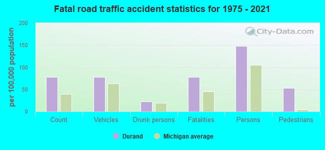
Durand fatal accident list:
Mar 17, 1991 08:00 PM, Oak St, Vehicles: 1, Persons: 3, Pedestrians: 1, Fatalities: 1, Drunk persons involved: 1
Jul 4, 1979 11:58 AM, Vehicles: 1, Persons: 2, Fatalities: 1
- National Bridge Inventory (NBI) Statistics
- 29Number of bridges
- 246ft / 75.2mTotal length
- 576,819Total average daily traffic
- 98,135Total average daily truck traffic
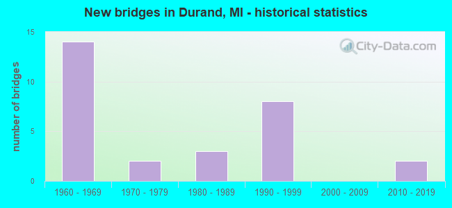
- New bridges - historical statistics
- 141960-1969
- 21970-1979
- 31980-1989
- 81990-1999
- 22010-2019
FCC Registered Antenna Towers:
32 (See the full list of FCC Registered Antenna Towers in Durand)FCC Registered Broadcast Land Mobile Towers:
10 (See the full list of FCC Registered Broadcast Land Mobile Towers in Durand, MI)FCC Registered Microwave Towers:
6- DURAND, 200 Railroad St (Lat: 42.908917 Lon: -83.981611), Overall height: 61 m, Call Sign: WNTQ220,
Assigned Frequencies: 952.081 MHz, 928.081 MHz, Grant Date: 12/04/2008, Expiration Date: 12/17/2018, Cancellation Date: 04/02/2018, Certifier: Theodore K Kalick, Registrant: Cn, 17641 South Ashland Avenue, Homewood, IL 60430, Phone: (708) 332-3543, Fax: (708) 332-6669, Email:
- DURAND, Various Locations (Lat: 42.955306 Lon: -83.986889), Structure height: 1.8 m, Call Sign: WPOP343, Licensee ID: L00033156,
Assigned Frequencies: 956.306 MHz, Grant Date: 09/27/2018, Expiration Date: 12/04/2028, Registrant: City Of Durand
- 4074, 9467 Goodall Road (Lat: 42.952278 Lon: -83.980361), Type: Ltower, Structure height: 91.4 m, Overall height: 92.4 m, Call Sign: WQRM778,
Assigned Frequencies: 11305.0 MHz, 11345.0 MHz, 11545.0 MHz, 11585.0 MHz, Grant Date: 05/16/2023, Expiration Date: 06/20/2033, Certifier: John Monday, Registrant: At&t Services, Inc., 208 S Akard St, 20f, Dallas, TX 75202, Phone: (855) 699-7073, Email:
- DURAND II REPL, South Durand Rd. (Lat: 42.931833 Lon: -83.990000), Type: Mtower, Structure height: 57.9 m, Overall height: 59.4 m, Call Sign: WQYV464,
Assigned Frequencies: 11345.0 MHz, 11465.0 MHz, Grant Date: 02/02/2017, Expiration Date: 02/02/2027, Cancellation Date: 01/24/2023, Certifier: Gregory M Romano, Registrant: Verizon, 1300 I St Nw - Suite 500 East, Washington, DC 20005, Phone: (202) 515-2453, Email:
- DURAND WATER TOWER, 299-201 W Clinton St (Lat: 42.911778 Lon: -83.986278), Type: Tank, Structure height: 56 m, Overall height: 57 m, Call Sign: WRAQ866,
Assigned Frequencies: 10755.0 MHz, 10755.0 MHz, 10995.0 MHz, 10995.0 MHz, 10755.0 MHz, 10755.0 MHz, 10995.0 MHz, 10995.0 MHz, 10755.0 MHz, 10755.0 MHz... (+6 more), Grant Date: 02/01/2018, Expiration Date: 02/01/2028, Certifier: Jeff Tebo, Registrant: Intelpath, Hinsdale, IL 60522, Phone: (312) 841-9188, Email:
- STATION, 200 Railroad St (Lat: 42.908917 Lon: -83.981611), Overall height: 61 m, Call Sign: WAA738,
Assigned Frequencies: 1945.00 MHz, 1935.00 MHz, 1985.00 MHz, Grant Date: 04/12/1995, Expiration Date: 04/12/2000, Cancellation Date: 06/06/1997, Phone: (313) 396-6700
FCC Registered Amateur Radio Licenses:
41 (See the full list of FCC Registered Amateur Radio Licenses in Durand)FAA Registered Aircraft Manufacturers and Dealers:
1 (See the full list of FAA Registered Manufacturers and Dealers in Durand)FAA Registered Aircraft:
17 (See the full list of FAA Registered Aircraft)2002 - 2018 National Fire Incident Reporting System (NFIRS) incidents
- Fire incident types reported to NFIRS in Durand, MI
- 28757.1%Structure Fires
- 12224.3%Outside Fires
- 7013.9%Mobile Property/Vehicle Fires
- 244.8%Other
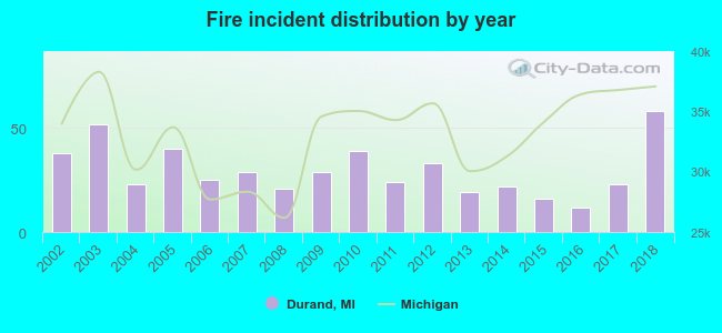 According to the data from the years 2002 - 2018 the average number of fire incidents per year is 30. The highest number of fire incidents - 58 took place in 2018, and the least - 12 in 2016. The data has an increasing trend.
 When looking into fire subcategories, the most reports belonged to: Structure Fires (57.1%), and Outside Fires (24.3%).
| Most common first names in Durand, MI among deceased individuals | ||
| Name | Count | Lived (average) |
|---|---|---|
| Mary | 45 | 78.6 years |
| Robert | 43 | 72.3 years |
| William | 42 | 74.1 years |
| George | 39 | 75.4 years |
| John | 34 | 75.3 years |
| Margaret | 33 | 78.2 years |
| Harold | 25 | 73.2 years |
| Dorothy | 23 | 79.9 years |
| James | 23 | 69.6 years |
| Charles | 23 | 72.9 years |
| Most common last names in Durand, MI among deceased individuals | ||
| Last name | Count | Lived (average) |
|---|---|---|
| Smith | 19 | 80.7 years |
| Johnson | 13 | 74.8 years |
| Perry | 13 | 73.9 years |
| Taylor | 12 | 65.4 years |
| Davis | 11 | 75.0 years |
| Cole | 11 | 74.4 years |
| Jones | 11 | 80.5 years |
| Hill | 10 | 81.2 years |
| Gooding | 7 | 73.5 years |
| Conrad | 7 | 79.7 years |
- 88.8%Utility gas
- 9.2%Electricity
- 2.0%Wood
- 51.0%Utility gas
- 41.8%Electricity
- 4.8%No fuel used
- 2.5%Bottled, tank, or LP gas
Durand compared to Michigan state average:
- Median house value below state average.
- Unemployed percentage below state average.
- Black race population percentage significantly below state average.
- Hispanic race population percentage significantly below state average.
- Foreign-born population percentage significantly below state average.
- House age above state average.
- Institutionalized population percentage above state average.
Durand on our top lists:
- #61 on the list of "Top 101 cities with the most residents born in Lebanon (population 500+)"
- #12 on the list of "Top 101 counties with the largest increase in the number of deaths per 1000 residents 2000-2006 to 2007-2013 (pop. 50,000+)"
- #30 on the list of "Top 101 counties with the largest number of people moving out compared to moving in (pop. 50,000+)"
- #60 on the list of "Top 101 counties with the lowest total withdrawal of fresh water for public supply (pop. 50,000+)"

|
|
Total of 38 patent applications in 2008-2024.