Dutch Fork, South Carolina
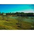
Dutch Fork: River Springs Elementary School on Connie Wright Road
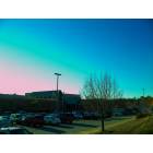
Dutch Fork: Northwest YMCA
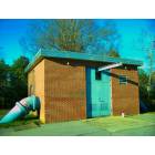
Dutch Fork: Pumphouse
- add
your
Submit your own pictures of this place and show them to the world
- OSM Map
- General Map
- Google Map
- MSN Map

| Males: 33,591 | |
| Females: 32,859 |
| Median resident age: | 31.5 years |
| South Carolina median age: | 35.4 years |
Zip code: 29063
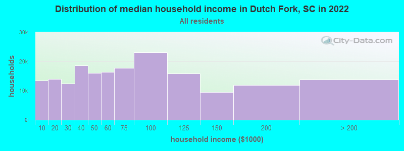
| Dutch Fork: | $65,432 |
| SC: | $64,115 |
Estimated per capita income in 2022: $37,519 (it was $21,554 in 2000)
Dutch Fork CCD income, earnings, and wages data
Estimated median house or condo value in 2022: $228,545 (it was $95,900 in 2000)
| Dutch Fork: | $228,545 |
| SC: | $254,600 |
Mean prices in 2022: all housing units: $288,364; detached houses: $299,656; townhouses or other attached units: $200,510; in 2-unit structures: $382,651; in 3-to-4-unit structures: $117,189; in 5-or-more-unit structures: $249,174; mobile homes: $64,043
Detailed information about poverty and poor residents in Dutch Fork, SC


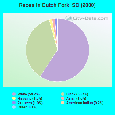
- 35,11759.2%White alone
- 21,60836.4%Black alone
- 8961.5%Asian alone
- 9041.5%Hispanic
- 5661.0%Two or more races
- 1160.2%American Indian alone
- 880.1%Other race alone
- 370.06%Native Hawaiian and Other
Pacific Islander alone
Races in Dutch Fork detailed stats: ancestries, foreign born residents, place of birth
 Recent articles from our blog. Our writers, many of them Ph.D. graduates or candidates, create easy-to-read articles on a wide variety of topics.
Current Local Time: EST time zone
Elevation: 980 feet
Land area: 83.5 square miles.
Population density: 796 people per square mile (low).

| Dutch Fork CCD: | 0.7% ($715) |
| South Carolina: | 0.6% ($510) |
Nearest city with pop. 200,000+: Charlotte, NC  (79.5 miles , pop. 540,828).
Nearest city with pop. 1,000,000+: Philadelphia, PA (526.2 miles , pop. 1,517,550).
Nearest cities:
Latitude: 34.09 N, Longitude: 81.16 W
Area code commonly used in this area: 803

| Here: | 3.1% |
| South Carolina: | 3.1% |
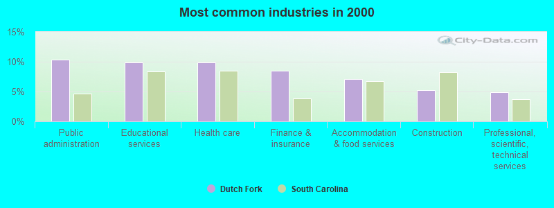
- Public administration (10.4%)
- Educational services (9.9%)
- Health care (9.8%)
- Finance & insurance (8.4%)
- Accommodation & food services (7.1%)
- Construction (5.2%)
- Professional, scientific, technical services (4.9%)
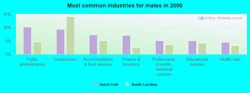
- Public administration (10.2%)
- Construction (9.4%)
- Accommodation & food services (7.3%)
- Finance & insurance (7.1%)
- Professional, scientific, technical services (5.1%)
- Educational services (5.1%)
- Health care (4.6%)
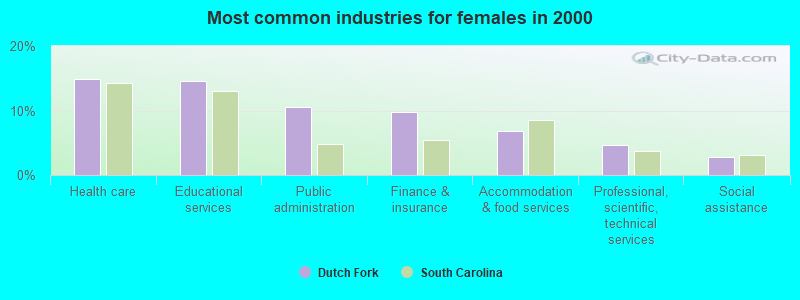
- Health care (14.9%)
- Educational services (14.6%)
- Public administration (10.5%)
- Finance & insurance (9.7%)
- Accommodation & food services (6.8%)
- Professional, scientific, technical services (4.6%)
- Social assistance (2.8%)
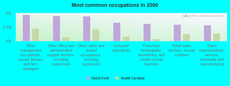
- Other management occupations, except farmers and farm managers (4.7%)
- Other office and administrative support workers, including supervisors (4.5%)
- Other sales and related occupations, including supervisors (4.5%)
- Computer specialists (3.4%)
- Preschool, kindergarten, elementary, and middle school teachers (3.1%)
- Retail sales workers, except cashiers (3.0%)
- Sales representatives, services, wholesale and manufacturing (2.9%)
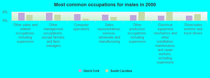
- Other sales and related occupations, including supervisors (5.7%)
- Other management occupations, except farmers and farm managers (5.7%)
- Computer specialists (4.8%)
- Sales representatives, services, wholesale and manufacturing (4.4%)
- Other production occupations, including supervisors (4.0%)
- Electrical equipment mechanics and other installation, maintenance, and repair workers, including supervisors (3.7%)
- Driver/sales workers and truck drivers (3.6%)
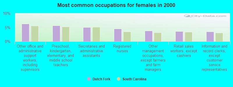
- Other office and administrative support workers, including supervisors (6.3%)
- Preschool, kindergarten, elementary, and middle school teachers (5.6%)
- Secretaries and administrative assistants (5.0%)
- Registered nurses (4.6%)
- Other management occupations, except farmers and farm managers (3.8%)
- Retail sales workers, except cashiers (3.7%)
- Information and record clerks, except customer service representatives (3.6%)
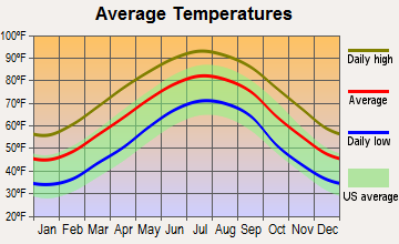
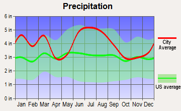
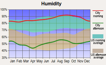
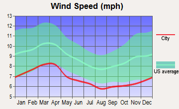
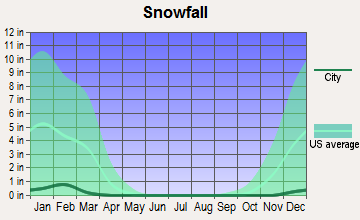
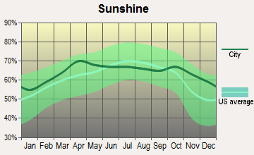
Average climate in Dutch Fork, South Carolina
Based on data reported by over 4,000 weather stations

(lower is better)
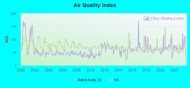
Air Quality Index (AQI) level in 2023 was 80.0. This is about average.
| City: | 80.0 |
| U.S.: | 72.6 |
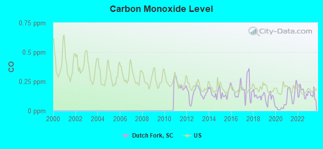
Carbon Monoxide (CO) [ppm] level in 2023 was 0.136. This is significantly better than average. Closest monitor was 8.5 miles away from the city center.
| City: | 0.136 |
| U.S.: | 0.251 |
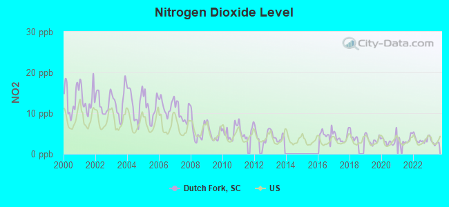
Nitrogen Dioxide (NO2) [ppb] level in 2023 was 2.97. This is significantly better than average. Closest monitor was 7.5 miles away from the city center.
| City: | 2.97 |
| U.S.: | 5.11 |
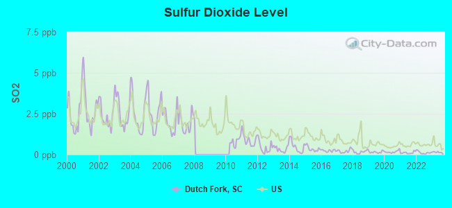
Sulfur Dioxide (SO2) [ppb] level in 2023 was 0.147. This is significantly better than average. Closest monitor was 8.5 miles away from the city center.
| City: | 0.147 |
| U.S.: | 1.515 |
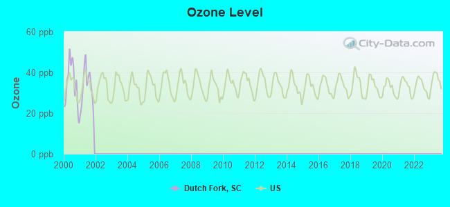
Ozone [ppb] level in 2001 was 32.6. This is about average. Closest monitor was 8.5 miles away from the city center.
| City: | 32.6 |
| U.S.: | 33.3 |
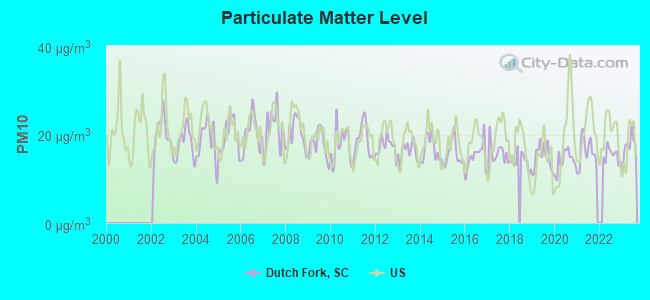
Particulate Matter (PM10) [µg/m3] level in 2023 was 17.2. This is about average. Closest monitor was 8.5 miles away from the city center.
| City: | 17.2 |
| U.S.: | 19.2 |
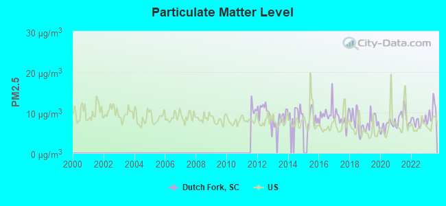
Particulate Matter (PM2.5) [µg/m3] level in 2023 was 9.96. This is worse than average. Closest monitor was 2.3 miles away from the city center.
| City: | 9.96 |
| U.S.: | 8.11 |
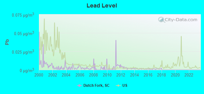
Lead (Pb) [µg/m3] level in 2017 was 0.00137. This is significantly better than average. Closest monitor was 1.6 miles away from the city center.
| City: | 0.00137 |
| U.S.: | 0.00931 |
Tornado activity:
Dutch Fork-area historical tornado activity is slightly above South Carolina state average. It is 33% greater than the overall U.S. average.
On 3/28/1984, a category F4 (max. wind speeds 207-260 mph) tornado 21.3 miles away from the Dutch Fork place center killed 5 people and injured 49 people and caused between $5,000,000 and $50,000,000 in damages.
On 8/16/1994, a category F3 (max. wind speeds 158-206 mph) tornado 7.0 miles away from the place center injured 40 people and caused between $5,000,000 and $50,000,000 in damages.
Earthquake activity:
Dutch Fork-area historical earthquake activity is significantly above South Carolina state average. It is 23% smaller than the overall U.S. average.On 8/2/1974 at 08:52:09, a magnitude 4.9 (4.3 MB, 4.9 LG, Class: Light, Intensity: IV - V) earthquake occurred 77.6 miles away from Dutch Fork center
On 8/9/2020 at 12:07:37, a magnitude 5.1 (5.1 MW, Depth: 4.7 mi, Class: Moderate, Intensity: VI - VII) earthquake occurred 165.0 miles away from the city center
On 11/22/1974 at 05:25:55, a magnitude 4.7 (4.7 MB) earthquake occurred 101.1 miles away from the city center
On 8/23/2011 at 17:51:04, a magnitude 5.8 (5.8 MW, Depth: 3.7 mi) earthquake occurred 319.8 miles away from Dutch Fork center
On 8/21/1992 at 16:31:55, a magnitude 4.4 (4.1 MB, 4.1 LG, 4.4 LG, Depth: 6.2 mi) earthquake occurred 93.9 miles away from the city center
On 2/15/2014 at 03:23:38, a magnitude 4.1 (4.1 MW, Depth: 3.2 mi) earthquake occurred 56.7 miles away from the city center
Magnitude types: regional Lg-wave magnitude (LG), body-wave magnitude (MB), moment magnitude (MW)
Natural disasters:
The number of natural disasters in Richland County (15) is near the US average (15).Major Disasters (Presidential) Declared: 7
Emergencies Declared: 6
Causes of natural disasters: Hurricanes: 7, Floods: 2, Storms: 2, Winter Storms: 2, Drought: 1, Ice Storm: 1, Tropical Storm: 1, Other: 1 (Note: some incidents may be assigned to more than one category).
Hospitals and medical centers near Dutch Fork:
- FRESENIUS MEDICAL CARE IRMO (Dialysis Facility, about 1 miles away; IRMO, SC)
- PALMETTO HOSPICE, LLC (Hospital, about 2 miles away; IRMO, SC)
- ASCENSION HOSPICE (Hospital, about 2 miles away; IRMO, SC)
- UNITED HOSPICE INC (Hospital, about 3 miles away; COLUMBIA, SC)
- BRIAN CENTER NURSING CARE - ST ANDREWS (Nursing Home, about 4 miles away; COLUMBIA, SC)
- HARMONY CARE HOSPICE, INC (Hospital, about 4 miles away; COLUMBIA, SC)
- PRESBYTERIAN HOME OF SC - COLUMBIA (Nursing Home, about 6 miles away; LEXINGTON, SC)
Operable nuclear power plant near Dutch Fork:
- 15 miles: Virgil C. Summer in Jenkinsville, SC.
Colleges/universities with over 2000 students nearest to Dutch Fork:
- Benedict College (about 10 miles; Columbia, SC; Full-time enrollment: 3,039)
- University of South Carolina-Columbia (about 10 miles; Columbia, SC; FT enrollment: 27,789)
- Midlands Technical College (about 11 miles; West Columbia, SC; FT enrollment: 8,916)
- Orangeburg Calhoun Technical College (about 43 miles; Orangeburg, SC; FT enrollment: 2,113)
- South Carolina State University (about 45 miles; Orangeburg, SC; FT enrollment: 3,481)
- Central Carolina Technical College (about 47 miles; Sumter, SC; FT enrollment: 3,108)
- University of South Carolina-Aiken (about 51 miles; Aiken, SC; FT enrollment: 2,815)
Points of interest:
Notable locations in Dutch Fork: Walden Correctional Institution (A), Columbia - Richland Fire Department Dutch Fork Spring Hill (B), Lowman Home for the Aged (C), Columbia - Richland Fire Department Harbison (D), Columbia - Richland Fire Station Dutch Fork Ballentine (E), Columbia - Richland Fire Department Saint Andrews (F). Display/hide their locations on the map
Shopping Centers: Widewater Shopping Center (1), Friarsgate Plaza Shopping Center (2), Dutch Square Shopping Center (3), Boozer Shopping Center (4). Display/hide their locations on the map
Churches in Dutch Fork include: Saint James Church (A), Saint Johns Church (B), Saint Peters Church (C), Shady Grove Church (D), Bethel Church (E), Bethlehem Church (F), Mount Olivet Church (G), Youngs Chapel (H), Broad River Church (I). Display/hide their locations on the map
Cemeteries: Golden Cemetery (1), Bethel Cemetery (2), Whites Cemetery (3), Threewits Cemetery (4), Thomas Boyd Cemetery (5), Schmitz Cemetery (6), Salem Cemetery (7). Display/hide their locations on the map
Lakes and reservoirs: Shimmys Pond (A), Meetze Pond (B). Display/hide their locations on the map
Streams, rivers, and creeks: Wildhorse Branch (A), Swygert Branch (B), Hollinshead Creek (C), Risters Creek (D), Wateree Creek (E), Nicholas Creek (F), Mussel Creek (G), Moccasin Branch (H), Saluda River (I). Display/hide their locations on the map
Parks in Dutch Fork include: Harrison State Forest (1), Riverbanks Zoo (2). Display/hide their locations on the map
| This place: | 2.4 people |
| South Carolina: | 2.5 people |
| This place: | 61.0% |
| Whole state: | 67.5% |
| This place: | 6.6% |
| Whole state: | 6.0% |
Likely homosexual households (counted as self-reported same-sex unmarried-partner households)
- Lesbian couples: 0.5% of all households
- Gay men: 0.4% of all households
| This place: | 9.1% |
| Whole state: | 14.1% |
| This place: | 3.8% |
| Whole state: | 6.5% |
People in group quarters in Dutch Fork in 2010:
- 5,733 people in state prisons
- 250 people in college/university student housing
- 214 people in correctional residential facilities
- 211 people in correctional facilities intended for juveniles
- 165 people in nursing facilities/skilled-nursing facilities
- 12 people in group homes intended for adults
- 10 people in residential treatment centers for adults
- 7 people in residential treatment centers for juveniles (non-correctional)
People in group quarters in Dutch Fork in 2000:
- 4,031 people in state prisons
- 711 people in training schools for juvenile delinquents
- 508 people in nursing homes
- 53 people in other noninstitutional group quarters
- 24 people in homes for the mentally retarded
- 3 people in local jails and other confinement facilities (including police lockups)
For population 15 years and over in Dutch Fork:
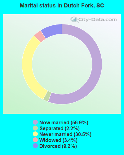
- Never married: 30.5%
- Now married: 56.9%
- Separated: 2.2%
- Widowed: 3.4%
- Divorced: 9.2%
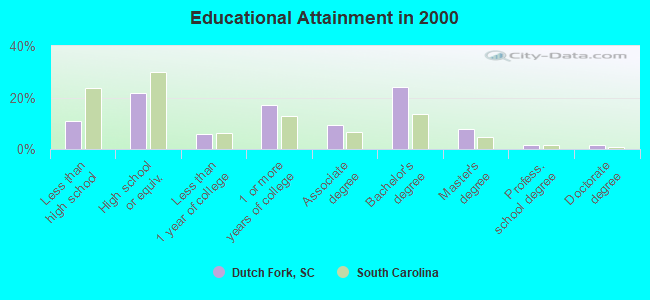
For population 25 years and over in Dutch Fork:
- High school or higher: 89.3%
- Bachelor's degree or higher: 35.0%
- Graduate or professional degree: 10.9%
- Unemployed: 3.1%
- Mean travel time to work (commute): 21.8 minutes
| Here: | 10.0 |
| South Carolina average: | 13.2 |
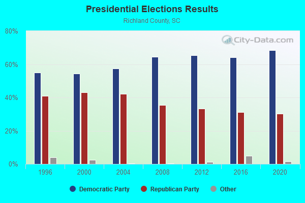
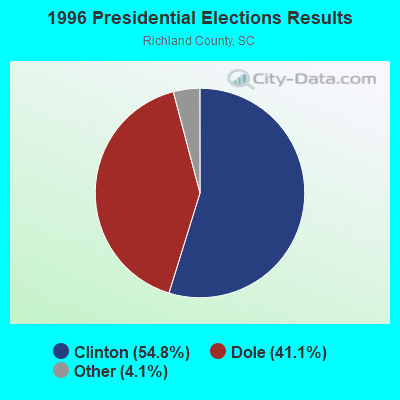

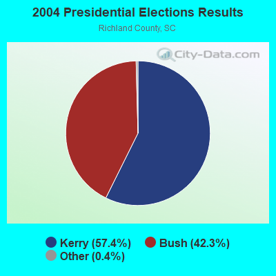
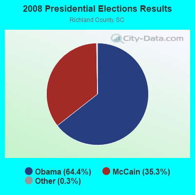
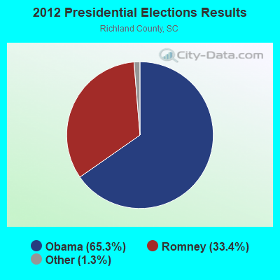
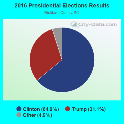
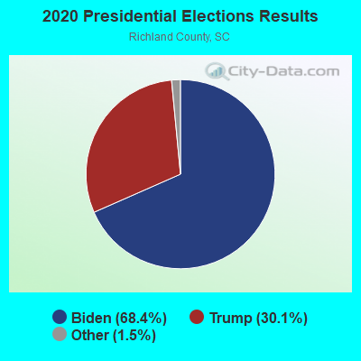
Graphs represent county-level data. Detailed 2008 Election Results
Religion statistics for Dutch Fork, SC (based on Richland County data)
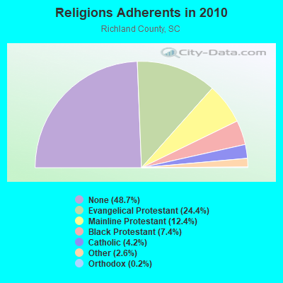
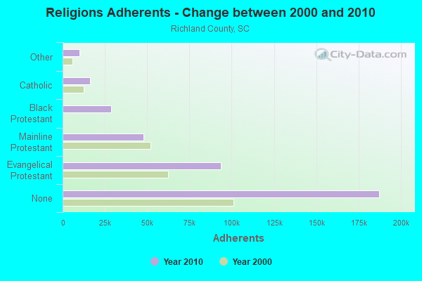
| Religion | Adherents | Congregations |
|---|---|---|
| Evangelical Protestant | 93,739 | 263 |
| Mainline Protestant | 47,813 | 98 |
| Black Protestant | 28,502 | 56 |
| Catholic | 16,300 | 8 |
| Other | 10,136 | 32 |
| Orthodox | 700 | 1 |
| None | 187,314 | - |
Food Environment Statistics:
| This county: | 1.48 / 10,000 pop. |
| South Carolina: | 1.99 / 10,000 pop. |
| Richland County: | 0.08 / 10,000 pop. |
| State: | 0.15 / 10,000 pop. |
| Richland County: | 0.39 / 10,000 pop. |
| South Carolina: | 0.85 / 10,000 pop. |
| Richland County: | 4.05 / 10,000 pop. |
| South Carolina: | 5.38 / 10,000 pop. |
| Richland County: | 7.04 / 10,000 pop. |
| State: | 7.75 / 10,000 pop. |
| Here: | 10.1% |
| South Carolina: | 10.6% |
| Richland County: | 30.0% |
| State: | 29.4% |
| Richland County: | 9.3% |
| South Carolina: | 13.4% |
9.04% of this county's 2021 resident taxpayers lived in other counties in 2020 ($52,630 average adjusted gross income)
| Here: | 9.04% |
| South Carolina average: | 8.89% |
0.11% of residents moved from foreign countries ($735 average AGI)
Richland County: 0.11% South Carolina average: 0.04%
Top counties from which taxpayers relocated into this county between 2020 and 2021:
| from Lexington County, SC | |
| from Kershaw County, SC | |
| from Sumter County, SC |
9.17% of this county's 2020 resident taxpayers moved to other counties in 2021 ($60,065 average adjusted gross income)
| Here: | 9.17% |
| South Carolina average: | 7.46% |
0.07% of residents moved to foreign countries ($494 average AGI)
Richland County: 0.07% South Carolina average: 0.03%
Top counties to which taxpayers relocated from this county between 2020 and 2021:
| to Lexington County, SC | |
| to Kershaw County, SC | |
| to Mecklenburg County, NC |
Strongest AM radio stations in Dutch Fork:
- WBAJ (890 AM; daytime; 50 kW; BLYTHEWOOD, SC; Owner: FAMILY FIRST)
- WVOC (560 AM; 5 kW; COLUMBIA, SC; Owner: CAPSTAR TX LIMITED PARTNERSHIP)
- WCEO (840 AM; daytime; 50 kW; COLUMBIA, SC; Owner: EASTERN BROADCASTING GROUP, INC.)
- WLGO (1170 AM; daytime; 10 kW; LEXINGTON, SC; Owner: LEVAS COMMUNICATIONS, LLC)
- WISW (1320 AM; 5 kW; COLUMBIA, SC; Owner: CITADEL BROADCASTING COMPANY)
- WQXL (1470 AM; 5 kW; COLUMBIA, SC; Owner: METRO COMMUNICATIONS, INCORP.)
- WBCU (1460 AM; 50 kW; UNION, SC)
- WGCV (620 AM; 1 kW; CAYCE, SC; Owner: GLORY COMMUNICATIONS, INC.)
- WAGL (1560 AM; daytime; 50 kW; LANCASTER, SC; Owner: PALMETTO BROADCASTING SYSTEM, INC.)
- WOIC (1230 AM; 1 kW; COLUMBIA, SC; Owner: URBAN RADIO OF SOUTH CAROLINA, LLC)
- WLFJ (660 AM; daytime; 50 kW; GREENVILLE, SC; Owner: CLEAR CHANNEL BROADCASTING LICENSES, INC.)
- WBT (1110 AM; 50 kW; CHARLOTTE, NC; Owner: JEFFERSON-PILOT COMMUNICATNS CO. OF NORTH CAROLINA)
- WCOS (1400 AM; 1 kW; COLUMBIA, SC; Owner: CAPSTAR TX LIMITED PARTNERSHIP)
Strongest FM radio stations in Dutch Fork:
- WMHK (89.7 FM; COLUMBIA, SC; Owner: COLUMBIA BIBLE COLLEGE B/CING CO.)
- WCOS-FM (97.5 FM; COLUMBIA, SC; Owner: CAPSTAR TX LIMITED PARTNERSHIP)
- WMFX (102.3 FM; ST. ANDREWS, SC; Owner: URBAN RADIO OF SOUTH CAROLINA, LLC)
- WXBT (100.1 FM; WEST COLUMBIA, SC; Owner: CAPSTAR TX LIMITED PARTNERSHIP)
- WNOK (104.7 FM; COLUMBIA, SC; Owner: CAPSTAR TX LIMITED PARTNERSHIP)
- WLTR (91.3 FM; COLUMBIA, SC; Owner: SOUTH CAROLINA EDUCATIONAL TV COMMISSION)
- WLTY (96.7 FM; CAYCE, SC; Owner: CAPSTAR TX LIMITED PARTNERSHIP)
- WARQ (93.5 FM; COLUMBIA, SC; Owner: URBAN RADIO OF SOUTH CAROLINA, LLC)
- W240AX (95.9 FM; COLUMBIA, SC; Owner: BIBLE BROADCASTING NETWORK, INC.)
- W222AD (92.3 FM; IRMO, SC; Owner: BIBLE BROADCASTING NETWORK, INC.)
- WWDM (101.3 FM; SUMTER, SC; Owner: URBAN RADIO OF SOUTH CAROLINA, LLC)
- WOMG (103.1 FM; COLUMBIA, SC; Owner: CITADEL BROADCASTING COMPANY)
- WUSC-FM (90.5 FM; COLUMBIA, SC; Owner: THE UNIVERSITY OF SOUTH CAROLINA)
- WZMJ (93.1 FM; BATESBURG, SC; Owner: URBAN RADIO OF SOUTH CAROLINA, LLC)
- W207BQ (89.3 FM; COLUMBIA, SC; Owner: CALVARY CHAPEL OF TWIN FALLS, INC.)
- WTCB (106.7 FM; ORANGEBURG, SC; Owner: CITADEL BROADCASTING COMPANY)
- WFMV (95.3 FM; SOUTH CONGAREE, SC; Owner: GLORY COMMUNICATIONS, INC.)
- WLXC (98.5 FM; LEXINGTON, SC; Owner: CITADEL BROADCASTING COMPANY)
- WYFV (88.7 FM; CAYCE, SC; Owner: BIBLE BROADCASTING NETWORK, INC.)
TV broadcast stations around Dutch Fork:
- W39CL (Channel 39; COLUMBIA, SC; Owner: NATIONAL MINORITY T.V., INC.)
- WRLK-TV (Channel 35; COLUMBIA, SC; Owner: SOUTH CAROLINA EDUCATIONAL TV COMMISSION)
- WOLO-TV (Channel 25; COLUMBIA, SC; Owner: SOUTH CAROLINA BROADCASTING PARTNERS)
- WLTX (Channel 19; COLUMBIA, SC; Owner: PACIFIC AND SOUTHERN COMPANY, INC.)
- WACH (Channel 57; COLUMBIA, SC; Owner: RAYCOM AMERICA, INC.)
- WIS (Channel 10; COLUMBIA, SC; Owner: LIBCO, INC.)
- W21CA (Channel 21; COLUMBIA, SC; Owner: DOVE BROADCASTING, INC.)
- WBHQ (Channel 63; SUMTER, SC; Owner: COLUMBIA BROADCASTING, INC.)
- W67DP (Channel 67; COLUMBIA, SC; Owner: DOVE BROADCASTING, INC.)
- W31BS (Channel 31; ORANGEBURG, SC; Owner: DOVE BROADCASTING INC.)
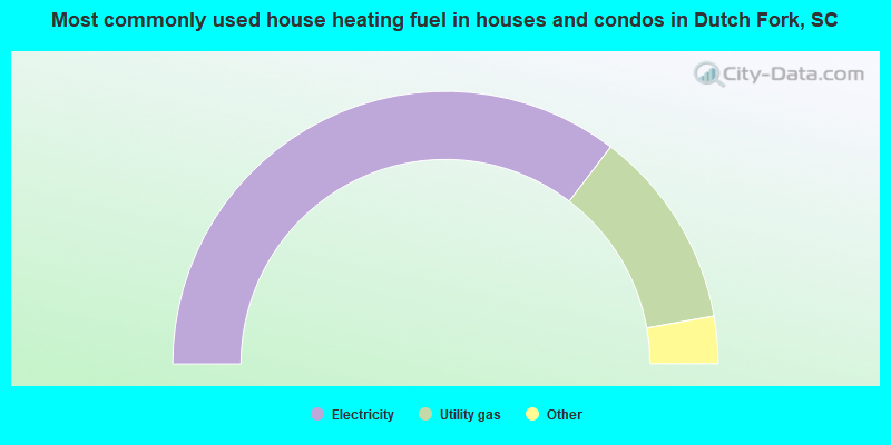
- 70.7%Electricity
- 23.7%Utility gas
- 3.8%Bottled, tank, or LP gas
- 1.0%Fuel oil, kerosene, etc.
- 0.7%Wood
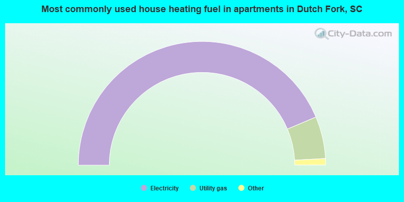
- 87.3%Electricity
- 11.0%Utility gas
- 1.0%Bottled, tank, or LP gas
- 0.5%No fuel used
- 0.2%Fuel oil, kerosene, etc.
Dutch Fork compared to South Carolina state average:
- Unemployed percentage significantly below state average.
- Hispanic race population percentage significantly below state average.
- Median age below state average.
- Foreign-born population percentage significantly below state average.
- Length of stay since moving in significantly above state average.
- Number of rooms per house significantly below state average.
- House age significantly below state average.
- Institutionalized population percentage significantly above state average.
- Percentage of population with a bachelor's degree or higher above state average.
Dutch Fork on our top lists:
- #2 on the list of "Top 101 cities with largest percentage of males in industries: metals and minerals, except petroleum, merchant wholesalers (population 50,000+)"
- #2 on the list of "Top 101 cities with largest percentage of males in industries: recyclable material merchant wholesalers (population 50,000+)"
- #2 on the list of "Top 101 cities with largest percentage of males in occupations: counselors, social workers, and other community and social service specialists (population 50,000+)"
- #3 on the list of "Top 101 cities with largest percentage of males in occupations: mathematical science occupations (population 50,000+)"
- #3 on the list of "Top 101 cities with largest percentage of males in industries: alcoholic beverages merchant wholesalers (population 50,000+)"
- #6 on the list of "Top 101 cities with largest percentage of males in occupations: judges, magistrates, and other judicial workers (population 50,000+)"
- #7 on the list of "Top 101 cities with largest percentage of females in occupations: therapists (population 50,000+)"
- #7 on the list of "Top 101 cities with largest percentage of males in occupations: therapists (population 50,000+)"
- #7 on the list of "Top 101 cities with largest percentage of males in industries: plastics and rubber products (population 50,000+)"
- #7 on the list of "Top 101 cities with largest percentage of males in occupations: religious workers (population 50,000+)"
- #7 on the list of "Top 101 cities with largest percentage of males in industries: textile mills and textile products (population 50,000+)"
- #8 on the list of "Top 101 cities with largest percentage of males in industries: hardware, plumbing and heating equipment, and supplies merchant wholesalers (population 50,000+)"
- #11 on the list of "Top 101 cities with largest percentage of females in industries: office supplies and stationery stores (population 50,000+)"
- #11 on the list of "Top 101 cities with largest percentage of males in industries: pharmacies and drug stores (population 50,000+)"
- #11 on the list of "Top 101 cities with largest percentage of males in industries: electrical equipment, appliances, and components (population 50,000+)"
- #12 on the list of "Top 101 cities with largest percentage of males in industries: office supplies and stationery stores (population 50,000+)"
- #12 on the list of "Top 101 cities with largest percentage of females in industries: textile mills and textile products (population 50,000+)"
- #13 on the list of "Top 101 cities with largest percentage of males in industries: social assistance (population 50,000+)"
- #13 on the list of "Top 101 cities with largest percentage of females in industries: nonmetallic mineral products (population 50,000+)"
- #15 on the list of "Top 101 cities with largest percentage of females in industries: electrical equipment, appliances, and components (population 50,000+)"
- #3 on the list of "Top 101 counties with the lowest lead air pollution readings in 2012 (µg/m3)"
- #10 on the list of "Top 101 counties with the lowest Ozone (1-hour) air pollution readings in 2012 (ppm)"
- #25 on the list of "Top 101 counties with the highest lead air pollution readings in 2012 (µg/m3)"
- #28 on the list of "Top 101 counties with the lowest Sulfur Oxides Annual air pollution readings in 2012 (µg/m3)"
- #32 on the list of "Top 101 counties with the most Black Protestant adherents"