East Colusa, California
Submit your own pictures of this place and show them to the world
- OSM Map
- General Map
- Google Map
- MSN Map

| Males: 4,606 | |
| Females: 4,636 |
| Median resident age: | 33.5 years |
| California median age: | 33.3 years |
Zip code: 95932
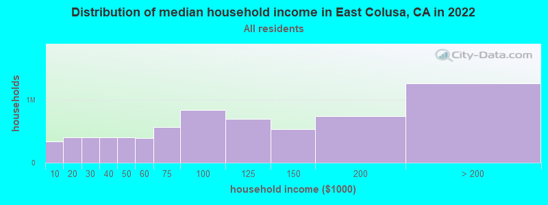
| East Colusa: | $66,833 |
| CA: | $91,551 |
Estimated per capita income in 2022: $33,518 (it was $15,115 in 2000)
East Colusa CCD income, earnings, and wages data
Estimated median house or condo value in 2022: $420,957 (it was $119,500 in 2000)
| East Colusa: | $420,957 |
| CA: | $715,900 |
Detailed information about poverty and poor residents in East Colusa, CA
Compare current foreclosures near East Colusa, CA:
| Photo | Address | Area | Beds / Baths | Price | Details |
|---|---|---|---|---|---|

|
#1
Dolbow Way
Arbuckle, CA 95912
|
1,717 sq. feet
|
2 baths 3 beds |
show details | |

|
#2
Voyager Ct
Colusa, CA 95932
|
- sq. feet
|
3 baths 4 beds |
show details | |

|
#3
California St
Sutter, CA 95982
|
- sq. feet
|
2 baths 3 beds |
show details | |

|
#4
3rd Ave
Sutter, CA 95982
|
- sq. feet
|
2 baths 3 beds |
show details | |

|
#5
1st St
Colusa, CA 95932
|
- sq. feet
|
- baths - beds |
show details | |

|
#6
Niagara Ave
Colusa, CA 95932
|
- sq. feet
|
- baths - beds |
show details | |

|
#7
Oak St
Colusa, CA 95932
|
- sq. feet
|
- baths - beds |
show details | |

|
#8
White Oak Dr
Williams, CA 95987
|
- sq. feet
|
- baths - beds |
show details | |

|
#9
Kleeman Way
Arbuckle, CA 95912
|
- sq. feet
|
- baths - beds |
show details | |

|
#10
River Rd
Colusa, CA 95932
|
- sq. feet
|
- baths - beds |
show details |
| Photo | Address | Area | Beds / Baths | Price | Details |
|---|---|---|---|---|---|

|
#11
Hunter Rd
Colusa, CA 95932
|
- sq. feet
|
- baths - beds |
show details | |

|
#12
Cynthia Dr
Colusa, CA 95932
|
- sq. feet
|
- baths - beds |
show details | |

|
#13
12th St
Colusa, CA 95932
|
- sq. feet
|
- baths - beds |
show details | |

|
#14
Oak St
Colusa, CA 95932
|
- sq. feet
|
- baths - beds |
show details | |

|
#15
Ware Ave
Colusa, CA 95932
|
- sq. feet
|
- baths - beds |
show details | |

|
#16
Country Club Dr
Colusa, CA 95932
|
- sq. feet
|
- baths - beds |
show details | |

|
#17
Nuestro Rd
Live Oak, CA 95953
|
- sq. feet
|
- baths - beds |
show details | |

|
Check over 1 million property listings on Foreclosure.com!
|
browse all offers | |||

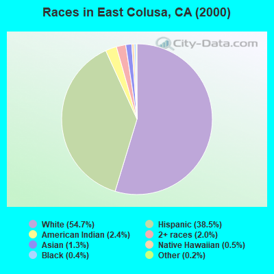
- 4,51554.7%White alone
- 3,17938.5%Hispanic
- 1962.4%American Indian alone
- 1612.0%Two or more races
- 1091.3%Asian alone
- 440.5%Native Hawaiian and Other
Pacific Islander alone - 290.4%Black alone
- 150.2%Other race alone
 Recent articles from our blog. Our writers, many of them Ph.D. graduates or candidates, create easy-to-read articles on a wide variety of topics.
Current Local Time: PST time zone
Land area: 265.9 square miles.
Population density: 35 people per square mile (very low).

| East Colusa CCD: | 0.6% ($740) |
| California: | 0.8% ($1,564) |
Nearest city with pop. 50,000+: Chico, CA  (38.0 miles , pop. 59,954).
Nearest city with pop. 200,000+: Sacramento, CA (52.9 miles , pop. 407,018).
Nearest city with pop. 1,000,000+: Los Angeles, CA (406.8 miles , pop. 3,694,820).
Nearest cities:
), ), ), ), Latitude: 39.20 N, Longitude: 121.99 W
Area code commonly used in this area: 530

| Here: | 16.2% |
| California: | 5.1% |
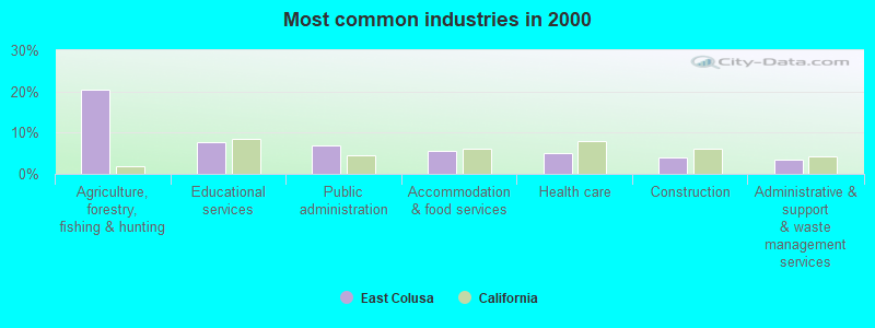
- Agriculture, forestry, fishing & hunting (20.5%)
- Educational services (7.6%)
- Public administration (7.0%)
- Accommodation & food services (5.5%)
- Health care (5.1%)
- Construction (3.9%)
- Administrative & support & waste management services (3.5%)
- Agriculture, forestry, fishing & hunting (31.0%)
- Construction (6.7%)
- Public administration (6.1%)
- Repair & maintenance (5.4%)
- Food (4.2%)
- Accommodation & food services (3.3%)
- Professional, scientific, technical services (3.3%)
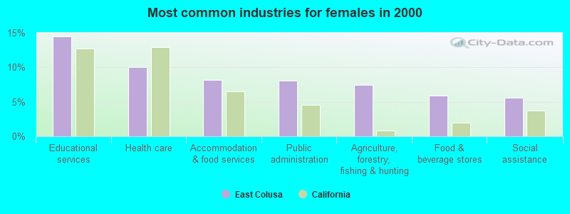
- Educational services (14.5%)
- Health care (10.0%)
- Accommodation & food services (8.2%)
- Public administration (8.0%)
- Agriculture, forestry, fishing & hunting (7.5%)
- Food & beverage stores (5.9%)
- Social assistance (5.6%)
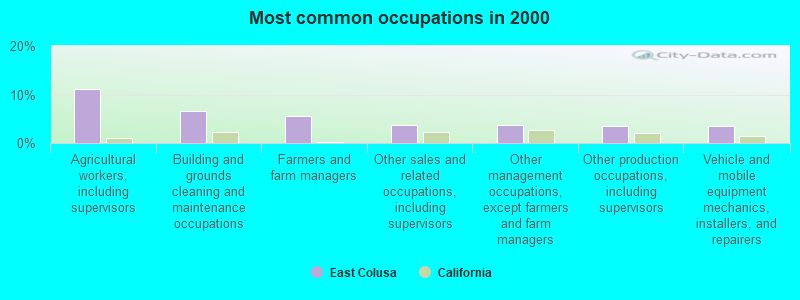
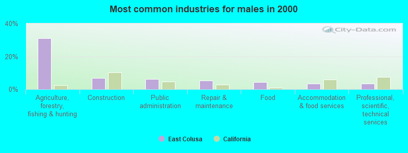
- Agricultural workers, including supervisors (11.2%)
- Building and grounds cleaning and maintenance occupations (6.6%)
- Farmers and farm managers (5.5%)
- Other sales and related occupations, including supervisors (3.8%)
- Other management occupations, except farmers and farm managers (3.6%)
- Other production occupations, including supervisors (3.4%)
- Vehicle and mobile equipment mechanics, installers, and repairers (3.4%)
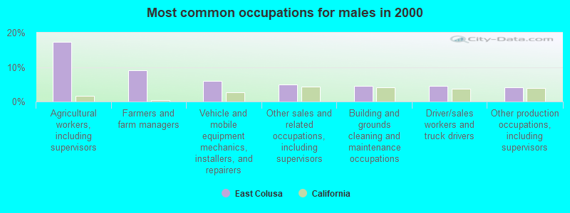
- Agricultural workers, including supervisors (17.3%)
- Farmers and farm managers (9.1%)
- Vehicle and mobile equipment mechanics, installers, and repairers (6.0%)
- Other sales and related occupations, including supervisors (5.0%)
- Building and grounds cleaning and maintenance occupations (4.6%)
- Driver/sales workers and truck drivers (4.6%)
- Other production occupations, including supervisors (4.1%)
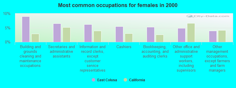
- Building and grounds cleaning and maintenance occupations (9.0%)
- Secretaries and administrative assistants (6.5%)
- Information and record clerks, except customer service representatives (6.2%)
- Cashiers (5.5%)
- Bookkeeping, accounting, and auditing clerks (5.3%)
- Other office and administrative support workers, including supervisors (4.9%)
- Other management occupations, except farmers and farm managers (3.9%)
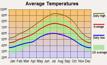
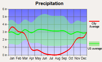
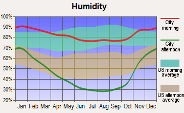
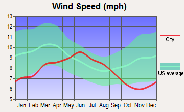
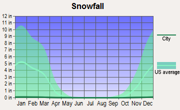
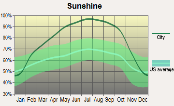
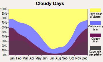
Average climate in East Colusa, California
Based on data reported by over 4,000 weather stations
(lower is better)
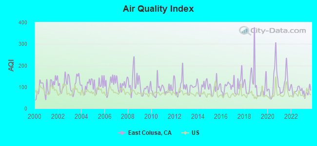
Air Quality Index (AQI) level in 2023 was 75.7. This is about average.
| City: | 75.7 |
| U.S.: | 72.6 |
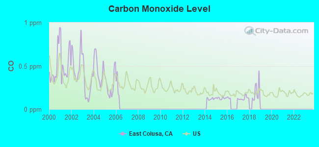
Carbon Monoxide (CO) [ppm] level in 2018 was 0.191. This is better than average. Closest monitor was 9.2 miles away from the city center.
| City: | 0.191 |
| U.S.: | 0.251 |
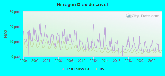
Nitrogen Dioxide (NO2) [ppb] level in 2022 was 6.65. This is worse than average. Closest monitor was 20.2 miles away from the city center.
| City: | 6.65 |
| U.S.: | 5.11 |
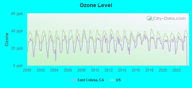
Ozone [ppb] level in 2022 was 26.6. This is better than average. Closest monitor was 1.1 miles away from the city center.
| City: | 26.6 |
| U.S.: | 33.3 |
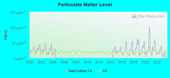
Particulate Matter (PM10) [µg/m3] level in 2022 was 20.3. This is about average. Closest monitor was 1.1 miles away from the city center.
| City: | 20.3 |
| U.S.: | 19.2 |
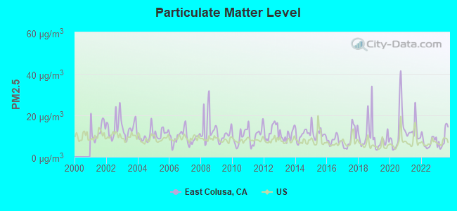
Particulate Matter (PM2.5) [µg/m3] level in 2023 was 8.70. This is about average. Closest monitor was 1.1 miles away from the city center.
| City: | 8.70 |
| U.S.: | 8.11 |
Earthquake activity:
East Colusa-area historical earthquake activity is significantly above California state average. It is 7167% greater than the overall U.S. average.On 4/18/1906 at 13:12:21, a magnitude 7.9 (7.9 UK, Class: Major, Intensity: VIII - XII) earthquake occurred 99.5 miles away from East Colusa center, causing $524,000,000 total damage
On 1/31/1922 at 13:17:28, a magnitude 7.6 (7.6 UK) earthquake occurred 215.3 miles away from the city center
On 4/25/1992 at 18:06:04, a magnitude 7.2 (6.3 MB, 7.1 MS, 7.2 MW, 7.1 MW, Depth: 9.4 mi) earthquake occurred 135.9 miles away from the city center, causing $75,000,000 total damage
On 10/3/1915 at 06:52:48, a magnitude 7.6 (7.6 UK) earthquake occurred 254.7 miles away from East Colusa center
On 10/18/1989 at 00:04:15, a magnitude 7.1 (6.5 MB, 7.1 MS, 6.9 MW, 7.0 ML) earthquake occurred 145.3 miles away from the city center, causing 62 deaths (62 shaking deaths) and 3757 injuries, causing $1,305,032,704 total damage
On 11/8/1980 at 10:27:34, a magnitude 7.2 (6.2 MB, 7.2 MS, 7.2 MW, 7.0 ML) earthquake occurred 179.6 miles away from East Colusa center
Magnitude types: body-wave magnitude (MB), local magnitude (ML), surface-wave magnitude (MS), moment magnitude (MW)
Natural disasters:
The number of natural disasters in Colusa County (16) is near the US average (15).Major Disasters (Presidential) Declared: 10
Emergencies Declared: 2
Causes of natural disasters: Floods: 12, Winter Storms: 6, Landslides: 5, Storms: 5, Mudslides: 4, Drought: 1, Freeze: 1, Heavy Rain: 1, Hurricane: 1, Tornado: 1, Other: 1 (Note: some incidents may be assigned to more than one category).
Hospitals and medical centers near East Colusa:
- COLUSA REGIONAL MEDICAL CENTER (Nursing Home, about 1 miles away; COLUSA, CA)
- COLUSA INDIAN HEALTH CLINIC DIALYSIS (Dialysis Facility, about 2 miles away; COLUSA, CA)
- VALLEY WEST CARE CENTER (Nursing Home, about 10 miles away; WILLIAMS, CA)
- VALLEY WEST CONVALESCENT HOSPITAL (Nursing Home, about 10 miles away; WILLIAMS, CA)
Colleges/universities with over 2000 students nearest to East Colusa:
- Yuba College (about 25 miles; Marysville, CA; Full-time enrollment: 4,737)
- Butte College (about 36 miles; Oroville, CA; FT enrollment: 8,649)
- California State University-Chico (about 38 miles; Chico, CA; FT enrollment: 14,838)
- Universal Technical Institute of Northern California Inc (about 46 miles; Sacramento, CA; FT enrollment: 3,193)
- University of Phoenix-Sacramento Valley Campus (about 48 miles; Sacramento, CA; FT enrollment: 2,855)
- University of California-Davis (about 48 miles; Davis, CA; FT enrollment: 30,845)
- Sierra College (about 51 miles; Rocklin, CA; FT enrollment: 11,488)
Points of interest:
Notable locations in East Colusa: Cachil Dehe Rancheria (A), Bell Outing Gun Club (B), Butte Lodge Outing Club (C), California Duck Club (D), Colusa Gun Club (E), Commodore Gun Club (F), Sycamore Siding (G), Princeton Siding (H), Howells Landing (I), Compton Landing (J), Keller Ranch (K), Boggs Landing (L), Mummas Landing (M), Wards Boat Landing (N), Colusa Golf and Country Club (O), Northern Gun Club (P), Limit Gun Club (Q), Lake Land Gun Club (R), Kuhl Gun Club (S), Colusa Carnegie Library (T). Display/hide their locations on the map
Shopping Centers: Green Mallard Duck Club (1), White Mallard Hunting Club (2). Display/hide their locations on the map
Churches in East Colusa include: Trinity United Methodist Church (A), Saint Stephens Episcopal Church (B), Pentecostal Church of God (C), First Baptist Church (D). Display/hide their locations on the map
Cemetery: Grand Island Cemetery (1). Display/hide its location on the map
Lakes: Cecil Lake (A), Sabin Lake (B). Display/hide their locations on the map
Streams, rivers, and creeks: Bounde Creek (A), Drumheller Slough (B), Freshwater Creek (C), Hopkins Slough (D), Lurline Creek (E), Onemile Creek (F), Butte Creek (G), Willow Creek (H), Stone Corral Creek (I). Display/hide their locations on the map
Parks in East Colusa include: Colusa National Wildlife Refuge (1), Colusa County Fairgrounds (2), Colusa Levee Scenic Park (3), Colusa Weir Recreation Area (4), Colusa-Sacramento River State Recreation Area (5). Display/hide their locations on the map
| This place: | 2.7 people |
| California: | 2.9 people |
| This place: | 70.9% |
| Whole state: | 68.7% |
| This place: | 6.6% |
| Whole state: | 7.2% |
Likely homosexual households (counted as self-reported same-sex unmarried-partner households)
- Lesbian couples: 0.3% of all households
- Gay men: 0.3% of all households
| This place: | 16.4% |
| Whole state: | 14.2% |
| This place: | 8.2% |
| Whole state: | 6.3% |
People in group quarters in East Colusa in 2010:
- 45 people in local jails and other municipal confinement facilities
- 8 people in emergency and transitional shelters (with sleeping facilities) for people experiencing homelessness
- 6 people in nursing facilities/skilled-nursing facilities
- 4 people in workers' group living quarters and job corps centers
People in group quarters in East Colusa in 2000:
- 67 people in local jails and other confinement facilities (including police lockups)
- 7 people in other noninstitutional group quarters
- 6 people in other nonhousehold living situations
For population 15 years and over in East Colusa:
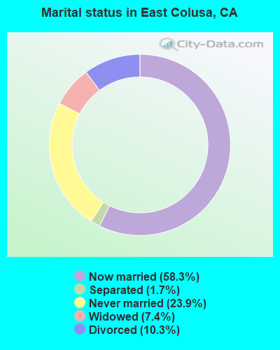
- Never married: 23.9%
- Now married: 58.3%
- Separated: 1.7%
- Widowed: 7.4%
- Divorced: 10.3%
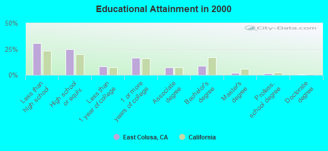
For population 25 years and over in East Colusa:
- High school or higher: 69.3%
- Bachelor's degree or higher: 12.6%
- Graduate or professional degree: 3.9%
- Unemployed: 7.8%
- Mean travel time to work (commute): 19.6 minutes
| Here: | 17.7 |
| California average: | 16.1 |
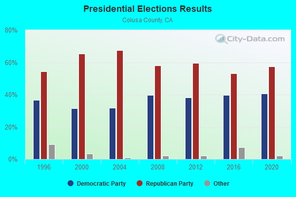
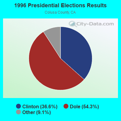
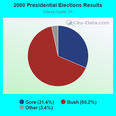
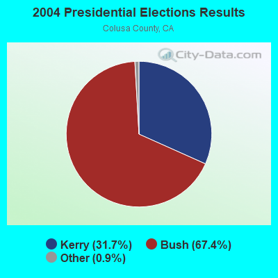
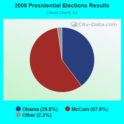
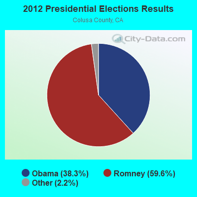
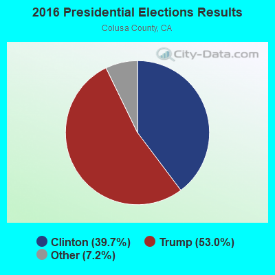

Graphs represent county-level data. Detailed 2008 Election Results
Religion statistics for East Colusa, CA (based on Colusa County data)
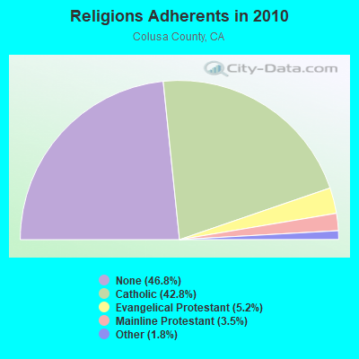
| Religion | Adherents | Congregations |
|---|---|---|
| Catholic | 9,170 | 6 |
| Evangelical Protestant | 1,106 | 13 |
| Mainline Protestant | 744 | 8 |
| Other | 379 | 2 |
| None | 10,020 | - |
Food Environment Statistics:
| Colusa County: | 4.26 / 10,000 pop. |
| State: | 2.14 / 10,000 pop. |
| Colusa County: | 2.36 / 10,000 pop. |
| California: | 0.62 / 10,000 pop. |
| Colusa County: | 4.26 / 10,000 pop. |
| State: | 1.49 / 10,000 pop. |
| This county: | 6.15 / 10,000 pop. |
| California: | 7.42 / 10,000 pop. |
| This county: | 7.8% |
| State: | 7.3% |
| Colusa County: | 24.2% |
| California: | 21.3% |
| Here: | 17.3% |
| California: | 17.9% |
Strongest AM radio stations in East Colusa:
- KFBK (1530 AM; 50 kW; SACRAMENTO, CA; Owner: AMFM RADIO LICENSES, L.L.C.)
- KFIA (710 AM; 25 kW; CARMICHAEL, CA; Owner: VISTA BROADCASTING INC.)
- KCBS (740 AM; 50 kW; SAN FRANCISCO, CA; Owner: INFINITY BROADCASTING OPERATIONS, INC.)
- KSTE (650 AM; 25 kW; RANCHO CORDOVA, CA; Owner: AMFM RADIO LICENSES, L.L.C.)
- KHTK (1140 AM; 50 kW; SACRAMENTO, CA; Owner: INFINITY RADIO SUBSIDIARY OPERATIONS INC.)
- KUBA (1600 AM; 5 kW; YUBA CITY, CA; Owner: HARLAN COMMUNICATIONS, INC.)
- KMYC (1410 AM; 5 kW; MARYSVILLE, CA; Owner: THOMAS F. HUTH)
- KTRB (860 AM; 50 kW; MODESTO, CA; Owner: PAPPAS RADIO OF CALIFORNIA, A CALIFORNIA LIMITED PARTNERSHIP)
- KNBR (680 AM; 50 kW; SAN FRANCISCO, CA; Owner: KNBR LICO, INC.)
- KCBC (770 AM; 50 kW; RIVERBANK, CA; Owner: KIERTRON, INC.)
- KGO (810 AM; 50 kW; SAN FRANCISCO, CA; Owner: KGO-AM RADIO, INC.)
- KKOH (780 AM; 50 kW; RENO, NV; Owner: CITADEL BROADCASTING COMPANY)
- KTCT (1050 AM; 50 kW; SAN MATEO, CA; Owner: SUSQUEHANNA RADIO CORP.)
Strongest FM radio stations in East Colusa:
- KKCY (103.1 FM; COLUSA, CA; Owner: RESULTS RADIO LICENSEE, LLC)
- KRCX-FM (99.9 FM; MARYSVILLE, CA; Owner: ENTRAVISION HOLDINGS, LLC)
- KMJE (101.5 FM; GRIDLEY, CA; Owner: RESULTS RADIO LICENSEE, LLC)
- K213BZ (90.5 FM; RICHVALE, CA; Owner: FAMILY STATIONS, INC.)
- KXCL (103.9 FM; YUBA CITY, CA; Owner: HARLAN COMMUNICATIONS, INC.)
- KNDL (89.9 FM; ANGWIN, CA; Owner: HOWELL MOUNTAIN BROADCASTING COMPANY)
- KLVR (91.9 FM; SANTA ROSA, CA; Owner: EDUCATIONAL MEDIA FOUNDATION)
- KXTS (100.9 FM; CALISTOGA, CA; Owner: SINCLAIR TELECABLE, INC.)
- KBBF (89.1 FM; SANTA ROSA, CA; Owner: BILINGUAL B/CING. FOUNDATION, INC.)
- KYIX (104.9 FM; SOUTH OROVILLE, CA; Owner: BUTTE BROADCASTING COMPANY, INC.)
- K258AQ (99.5 FM; YANKEE HILL, CA; Owner: CALVARY CHAPEL OF TWIN FALLS, INC.)
- K284AG (104.7 FM; WOODLAND, CA; Owner: EDUCATIONAL MEDIA FOUNDATION)
- KQPT (107.5 FM; COLUSA, CA; Owner: REGENT LICENSEE OF CHICO, INC)
- KSXY (98.7 FM; MIDDLETOWN, CA; Owner: COMMONWEALTH BROADCASTING, LLC)
- KKFS (105.5 FM; DUNNIGAN, CA; Owner: CARON BROADCASTING, INC.)
- KHAP (89.1 FM; CHICO, CA; Owner: FAMILY STATIONS, INC.)
- KHHZ (97.7 FM; OROVILLE, CA; Owner: CLEAR CHANNEL BROADCASTING LICENSES, INC.)
- KUIC (95.3 FM; VACAVILLE, CA; Owner: KUIC, INC.)
- KFGY (92.9 FM; HEALDSBURG, CA; Owner: MAVERICK MEDIA OF SANTA ROSA LICENSE LLC)
- KWNE (94.5 FM; UKIAH, CA; Owner: BROADCASTING CORP. OF MENDICINO CTY.)
TV broadcast stations around East Colusa:
- KEZT-CA (Channel 23; SACRAMENTO, CA; Owner: TELEFUTURA SACRAMENTO LLC)
- KMMK-LP (Channel 14; SACRAMENTO, CA; Owner: CABALLERO TELEVISION TEXAS, L.L.C.)
- 75.1%Utility gas
- 13.4%Electricity
- 6.5%Bottled, tank, or LP gas
- 4.4%Wood
- 0.3%Fuel oil, kerosene, etc.
- 0.2%No fuel used
- 0.1%Other fuel
- 55.8%Utility gas
- 29.1%Electricity
- 14.1%Bottled, tank, or LP gas
- 0.5%Fuel oil, kerosene, etc.
- 0.4%Wood
East Colusa compared to California state average:
- Median house value below state average.
- Unemployed percentage below state average.
- Black race population percentage significantly below state average.
- Foreign-born population percentage significantly below state average.
- Length of stay since moving in significantly above state average.
- Number of rooms per house significantly below state average.
- House age significantly below state average.
- Percentage of population with a bachelor's degree or higher below state average.
East Colusa on our top lists:
- #5 on the list of "Top 101 cities with largest percentage of males in industries: farm supplies merchant wholesalers (population 5,000+)"
- #6 on the list of "Top 101 cities with largest percentage of males in occupations: farmers and farm managers (population 5,000+)"
- #7 on the list of "Top 101 cities with largest percentage of males in occupations: legal support workers (population 5,000+)"
- #9 on the list of "Top 101 cities with largest percentage of males in occupations: agricultural workers including supervisors (population 5,000+)"
- #11 on the list of "Top 101 cities with largest percentage of males in industries: machinery, equipment, and supplies merchant wholesalers (population 5,000+)"
- #17 on the list of "Top 101 cities with largest percentage of females in industries: private households (population 5,000+)"
- #20 on the list of "Top 101 cities with largest percentage of females in industries: machinery, equipment, and supplies merchant wholesalers (population 5,000+)"
- #25 on the list of "Top 101 cities with largest percentage of females in industries: groceries and related products merchant wholesalers (population 5,000+)"
- #26 on the list of "Top 101 cities with largest percentage of females in industries: u. s. postal service (population 5,000+)"
- #27 on the list of "Top 101 cities with largest percentage of females in occupations: agricultural workers including supervisors (population 5,000+)"
- #36 on the list of "Top 101 cities with largest percentage of males in industries: food (population 5,000+)"
- #40 on the list of "Top 101 cities with largest percentage of females in industries: gasoline stations (population 5,000+)"
- #43 on the list of "Top 101 cities with largest percentage of males in industries: agriculture, forestry, fishing and hunting (population 5,000+)"
- #50 on the list of "Top 101 cities with largest percentage of females in occupations: bookkeeping, accounting, and auditing clerks (population 5,000+)"
- #56 on the list of "Top 101 cities with largest percentage of males in industries: motor vehicles, parts and supplies merchant wholesalers (population 5,000+)"
- #58 on the list of "Top 101 cities with largest percentage of males in industries: repair and maintenance (population 5,000+)"
- #60 on the list of "Top 101 cities with largest percentage of females in industries: music stores (population 5,000+)"
- #62 on the list of "Top 101 cities with largest percentage of males in occupations: judges, magistrates, and other judicial workers (population 5,000+)"
- #65 on the list of "Top 101 cities with largest percentage of females in industries: food and beverage stores (population 5,000+)"
- #92 on the list of "Top 101 cities with largest percentage of females in industries: agriculture, forestry, fishing and hunting (population 5,000+)"