Elwood-Magnolia, New Jersey
Submit your own pictures of this place and show them to the world
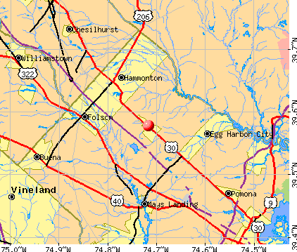
- OSM Map
- General Map
- Google Map
- MSN Map
| Males: 746 | |
| Females: 739 |
| Median resident age: | 34.0 years |
| New Jersey median age: | 36.7 years |
Zip codes: 08217.
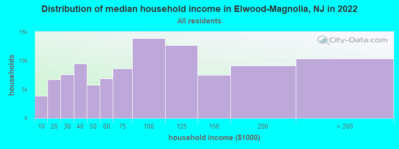
| Elwood-Magnolia: | $74,034 |
| NJ: | $96,346 |
Estimated per capita income in 2022: $26,033 (it was $13,678 in 2000)
Elwood-Magnolia CDP income, earnings, and wages data
Estimated median house or condo value in 2022: $195,571 (it was $80,000 in 2000)
| Elwood-Magnolia: | $195,571 |
| NJ: | $428,900 |
Mean prices in 2022: all housing units: $322,455; detached houses: $342,915; townhouses or other attached units: $242,067; in 2-unit structures: $375,830; in 3-to-4-unit structures: $559,002; in 5-or-more-unit structures: $207,614; mobile homes: $114,977; occupied boats, rvs, vans, etc.: over $1,000,000
Elwood-Magnolia, NJ residents, houses, and apartments details
Detailed information about poverty and poor residents in Elwood-Magnolia, NJ


- 65146.8%White alone
- 51336.9%Hispanic
- 18012.9%Black alone
- 271.9%Two or more races
- 120.9%Asian alone
- 30.2%American Indian alone
- 30.2%Native Hawaiian and Other
Pacific Islander alone - 30.2%Other race alone
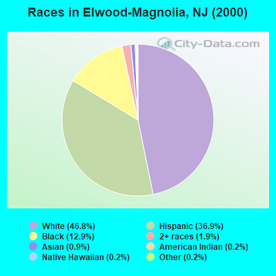
Races in Elwood-Magnolia detailed stats: ancestries, foreign born residents, place of birth
 Recent articles from our blog. Our writers, many of them Ph.D. graduates or candidates, create easy-to-read articles on a wide variety of topics.

 | Atlantic/Cumberland/Cape May towns "missing" from City Data (0 replies) |
Ancestries: Irish (17.7%), Italian (15.2%), German (14.3%), United States (5.4%), English (4.5%), Dutch (2.4%).
Current Local Time: EST time zone
Land area: 3.22 square miles.
Population density: 461 people per square mile (low).
| Elwood-Magnolia CDP: | 2.3% ($1,853) |
| New Jersey: | 2.4% ($4,047) |
Nearest city with pop. 50,000+: Vineland, NJ  (17.2 miles , pop. 56,271).
Nearest city with pop. 200,000+: Philadelphia, PA (36.9 miles , pop. 1,517,550).
Nearest cities:
), ), ), ), Latitude: 39.58 N, Longitude: 74.72 W
Area code commonly used in this area: 609
| Here: | 6.1% |
| New Jersey: | 4.5% |
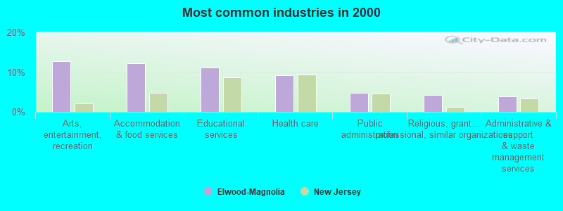
- Arts, entertainment, recreation (12.7%)
- Accommodation & food services (12.2%)
- Educational services (11.2%)
- Health care (9.3%)
- Public administration (4.8%)
- Religious, grantmaking, civic, professional, similar organizations (4.3%)
- Administrative & support & waste management services (4.0%)
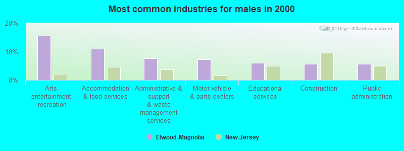
- Arts, entertainment, recreation (15.6%)
- Accommodation & food services (10.9%)
- Administrative & support & waste management services (7.6%)
- Motor vehicle & parts dealers (7.3%)
- Educational services (6.0%)
- Construction (5.6%)
- Public administration (5.6%)
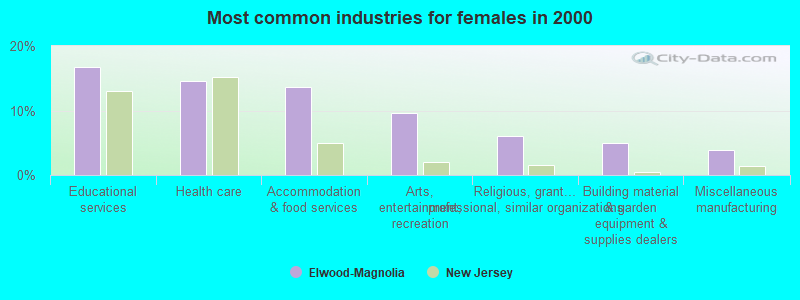
- Educational services (16.8%)
- Health care (14.6%)
- Accommodation & food services (13.6%)
- Arts, entertainment, recreation (9.6%)
- Religious, grantmaking, civic, professional, similar organizations (6.1%)
- Building material & garden equipment & supplies dealers (5.0%)
- Miscellaneous manufacturing (3.9%)
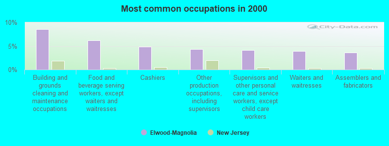
- Building and grounds cleaning and maintenance occupations (8.6%)
- Food and beverage serving workers, except waiters and waitresses (6.2%)
- Cashiers (4.8%)
- Other production occupations, including supervisors (4.3%)
- Supervisors and other personal care and service workers, except child care workers (4.1%)
- Waiters and waitresses (4.0%)
- Assemblers and fabricators (3.6%)
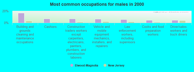
- Building and grounds cleaning and maintenance occupations (16.6%)
- Cashiers (7.0%)
- Construction traders workers except carpenters, electricians, painters, plumbers, and construction laborers (7.0%)
- Vehicle and mobile equipment mechanics, installers, and repairers (6.6%)
- Law enforcement workers, including supervisors (5.6%)
- Cooks and food preparation workers (4.6%)
- Driver/sales workers and truck drivers (4.3%)
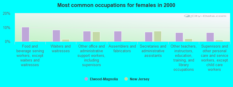
- Food and beverage serving workers, except waiters and waitresses (10.4%)
- Waiters and waitresses (8.2%)
- Other office and administrative support workers, including supervisors (7.5%)
- Assemblers and fabricators (7.5%)
- Secretaries and administrative assistants (6.8%)
- Other teachers, instructors, education, training, and library occupations (6.4%)
- Supervisors and other personal care and service workers, except child care workers (6.4%)
Average climate in Elwood-Magnolia, New Jersey
Based on data reported by over 4,000 weather stations


(lower is better)
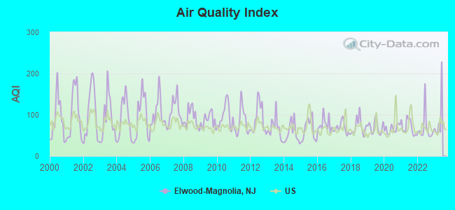
Air Quality Index (AQI) level in 2022 was 66.9. This is about average.
| City: | 66.9 |
| U.S.: | 72.6 |
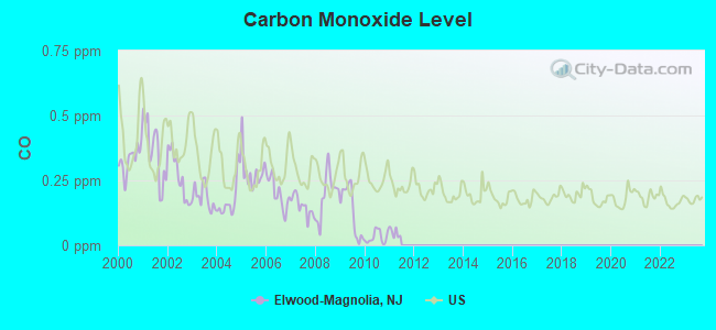
Carbon Monoxide (CO) [ppm] level in 2010 was 0.0318. This is significantly better than average. Closest monitor was 10.7 miles away from the city center.
| City: | 0.0318 |
| U.S.: | 0.2513 |
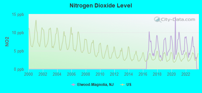
Nitrogen Dioxide (NO2) [ppb] level in 2022 was 5.99. This is about average. Closest monitor was 10.7 miles away from the city center.
| City: | 5.99 |
| U.S.: | 5.11 |
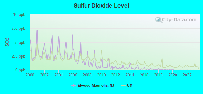
Sulfur Dioxide (SO2) [ppb] level in 2022 was 0.00369. This is significantly better than average. Closest monitor was 10.7 miles away from the city center.
| City: | 0.00369 |
| U.S.: | 1.51465 |
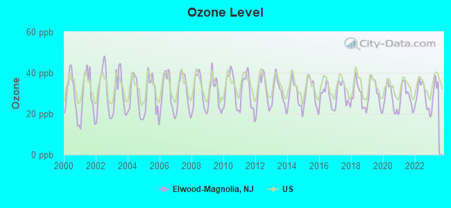
Ozone [ppb] level in 2022 was 28.9. This is about average. Closest monitor was 10.7 miles away from the city center.
| City: | 28.9 |
| U.S.: | 33.3 |
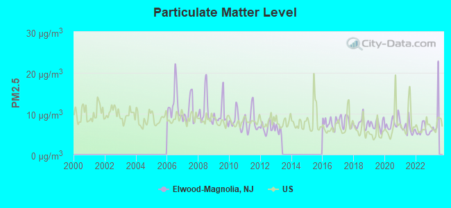
Particulate Matter (PM2.5) [µg/m3] level in 2022 was 5.87. This is better than average. Closest monitor was 16.3 miles away from the city center.
| City: | 5.87 |
| U.S.: | 8.11 |
Tornado activity:
Elwood-Magnolia-area historical tornado activity is slightly below New Jersey state average. It is 39% smaller than the overall U.S. average.
On 7/21/1983, a category F3 (max. wind speeds 158-206 mph) tornado 24.1 miles away from the Elwood-Magnolia place center caused between $500,000 and $5,000,000 in damages.
On 8/21/1993, a category F2 (max. wind speeds 113-157 mph) tornado 6.6 miles away from the place center caused between $50,000 and $500,000 in damages.
Earthquake activity:
Elwood-Magnolia-area historical earthquake activity is significantly above New Jersey state average. It is 68% smaller than the overall U.S. average.On 8/23/2011 at 17:51:04, a magnitude 5.8 (5.8 MW, Depth: 3.7 mi, Class: Moderate, Intensity: VI - VII) earthquake occurred 208.5 miles away from the city center
On 1/16/1994 at 01:49:16, a magnitude 4.6 (4.6 MB, 4.6 LG, Depth: 3.1 mi, Class: Light, Intensity: IV - V) earthquake occurred 87.2 miles away from Elwood-Magnolia center
On 11/30/2017 at 21:47:31, a magnitude 4.1 (4.1 MW, Depth: 6.1 mi) earthquake occurred 46.4 miles away from Elwood-Magnolia center
On 1/16/1994 at 00:42:43, a magnitude 4.2 (4.2 MB, 4.0 LG, Depth: 3.1 mi) earthquake occurred 85.8 miles away from the city center
On 10/7/1983 at 10:18:46, a magnitude 5.3 (5.1 MB, 5.3 LG, 5.1 ML) earthquake occurred 303.3 miles away from Elwood-Magnolia center
On 1/15/2019 at 23:30:48, a magnitude 4.6 (4.6 MW, Depth: 6.2 mi) earthquake occurred 186.8 miles away from the city center
Magnitude types: regional Lg-wave magnitude (LG), body-wave magnitude (MB), local magnitude (ML), moment magnitude (MW)
Natural disasters:
The number of natural disasters in Atlantic County (32) is a lot greater than the US average (15).Major Disasters (Presidential) Declared: 23
Emergencies Declared: 9
Causes of natural disasters: Storms: 10, Floods: 8, Hurricanes: 7, Snowstorms: 5, Winter Storms: 3, Blizzards: 2, Heavy Rains: 2, Water Shortages: 2, Winds: 2, Tropical Depression: 1, Tropical Storm: 1, Other: 3 (Note: some incidents may be assigned to more than one category).
Hospitals and medical centers near Elwood-Magnolia:
- HAMMONTON CENTER FOR REHABILITATION AND HEALTHCARE (Nursing Home, about 7 miles away; HAMMONTON, NJ)
- LIBERTY HAMMONTON (Dialysis Facility, about 8 miles away; HAMMONTON, NJ)
- WESTSIDE CONVALESCENT CENTER (Nursing Home, about 9 miles away; ATLANTIC CITY, NJ)
- ROYAL SUITES HEALTH CARE AND REHABILITATION (Nursing Home, about 11 miles away; GALLOWAY TOWNSHIP, NJ)
- ATLANTICARE SURGERY CENTER (Hospital, about 12 miles away; EGG HARBOR TOWNSHIP, NJ)
- HEALTH CENTER AT GALLOWAY, THE (Nursing Home, about 12 miles away; GALLOWAY TOWNSHIP, NJ)
- RENAISSANCE PAVILION (Nursing Home, about 12 miles away; POMONA, NJ)
Colleges/universities with over 2000 students nearest to Elwood-Magnolia:
- Atlantic Cape Community College (about 9 miles; Mays Landing, NJ; Full-time enrollment: 5,392)
- The Richard Stockton College of New Jersey (about 12 miles; Galloway, NJ; FT enrollment: 8,360)
- Cumberland County College (about 21 miles; Vineland, NJ; FT enrollment: 2,898)
- Camden County College (about 23 miles; Blackwood, NJ; FT enrollment: 9,901)
- Rowan University (about 24 miles; Glassboro, NJ; FT enrollment: 10,632)
- Gloucester County College (about 26 miles; Sewell, NJ; FT enrollment: 5,490)
- Burlington County College (about 28 miles; Pemberton, NJ; FT enrollment: 7,928)
Points of interest:
Notable locations in Elwood-Magnolia: Mullica Township Rescue (A), Elwood Volunteer Fire Company Station 160 (B). Display/hide their locations on the map
| This place: | 3.2 people |
| New Jersey: | 2.7 people |
| This place: | 78.2% |
| Whole state: | 70.7% |
| This place: | 8.4% |
| Whole state: | 4.9% |
Likely homosexual households (counted as self-reported same-sex unmarried-partner households)
- Lesbian couples: 0.0% of all households
- Gay men: 1.2% of all households
| This place: | 24.5% |
| Whole state: | 8.5% |
| This place: | 4.9% |
| Whole state: | 4.2% |
People in group quarters in Elwood-Magnolia in 2000:
- 17 people in homes for the mentally ill
- 14 people in other noninstitutional group quarters
- 6 people in homes for the mentally retarded
For population 15 years and over in Elwood-Magnolia:
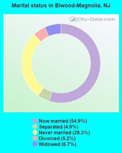
- Never married: 28.3%
- Now married: 54.9%
- Separated: 4.9%
- Widowed: 6.7%
- Divorced: 5.2%
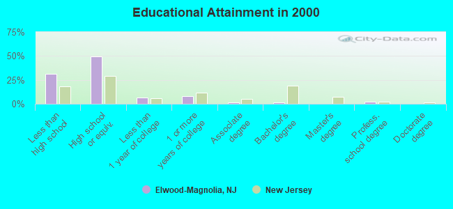
For population 25 years and over in Elwood-Magnolia:
- High school or higher: 68.4%
- Bachelor's degree or higher: 3.4%
- Graduate or professional degree: 1.9%
- Unemployed: 5.8%
- Mean travel time to work (commute): 25.7 minutes
| Here: | 13.0 |
| New Jersey average: | 13.1 |
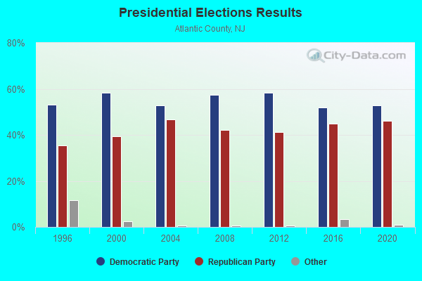
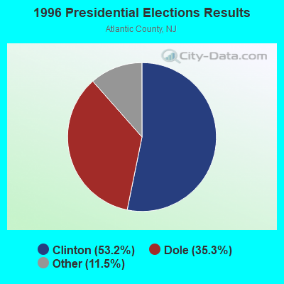
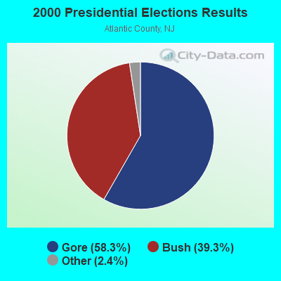
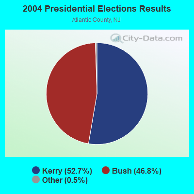
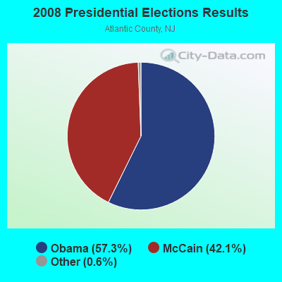

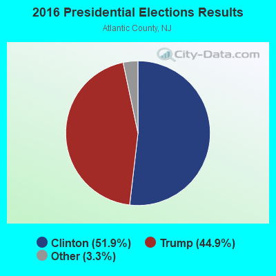
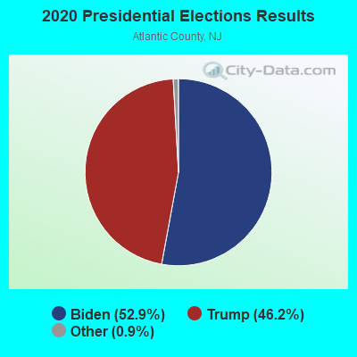
Graphs represent county-level data. Detailed 2008 Election Results
Religion statistics for Elwood-Magnolia, NJ (based on Atlantic County data)
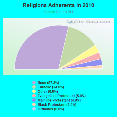
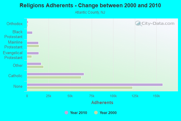
| Religion | Adherents | Congregations |
|---|---|---|
| Catholic | 65,867 | 23 |
| Other | 16,570 | 27 |
| Evangelical Protestant | 13,661 | 100 |
| Mainline Protestant | 13,250 | 57 |
| Black Protestant | 6,321 | 19 |
| Orthodox | 1,520 | 5 |
| None | 157,360 | - |
Food Environment Statistics:
| This county: | 2.52 / 10,000 pop. |
| State: | 2.90 / 10,000 pop. |
| This county: | 0.07 / 10,000 pop. |
| New Jersey: | 0.06 / 10,000 pop. |
| Atlantic County: | 2.04 / 10,000 pop. |
| State: | 1.76 / 10,000 pop. |
| Atlantic County: | 0.89 / 10,000 pop. |
| New Jersey: | 0.81 / 10,000 pop. |
| This county: | 11.52 / 10,000 pop. |
| New Jersey: | 7.15 / 10,000 pop. |
| This county: | 10.0% |
| New Jersey: | 8.3% |
| Atlantic County: | 26.5% |
| New Jersey: | 23.3% |
| Atlantic County: | 19.0% |
| New Jersey: | 18.0% |
4.72% of this county's 2020 resident taxpayers moved to other counties in 2021 ($64,371 average adjusted gross income)
| Here: | 4.72% |
| New Jersey average: | 7.02% |
0.02% of residents moved to foreign countries ($83 average AGI)
Atlantic County: 0.02% New Jersey average: 0.02%
Top counties to which taxpayers relocated from this county between 2020 and 2021:
| to Camden County, NJ | |
| to Cumberland County, NJ | |
| to Gloucester County, NJ |
Strongest AM radio stations in Elwood-Magnolia:
- WPHT (1210 AM; 50 kW; PHILADELPHIA, PA; Owner: INFINITY BROADCASTING OPERATIONS, INC.)
- WVCH (740 AM; 50 kW; CHESTER, PA; Owner: WVCH COMMUNICATIONS, INC.)
- WPEN (950 AM; 50 kW; PHILADELPHIA, PA; Owner: GREATER PHILADELPHIA RADIO, INC.)
- WZZD (990 AM; 50 kW; PHILADELPHIA, PA; Owner: PENNSYLVANIA MEDIA ASSOCIATES, INC.)
- WGYM (1580 AM; 1 kW; HAMMONTON, NJ)
- KYW (1060 AM; 50 kW; PHILADELPHIA, PA; Owner: INFINITY BROADCASTING OPERATIONS, INC.)
- WWJZ (640 AM; 50 kW; MOUNT HOLLY, NJ; Owner: ABC, INC.)
- WNWR (1540 AM; 50 kW; PHILADELPHIA, PA)
- WMCA (570 AM; 50 kW; NEW YORK, NY; Owner: SALEM MEDIA OF NEW YORK, LLC)
- WNJC (1360 AM; 5 kW; VINELAND, NJ; Owner: FORSYTHE BROADCASTING, INC.)
- WIP (610 AM; 5 kW; PHILADELPHIA, PA; Owner: INFINITY BROADCASTING CORPORATION OF PHILADELPHIA)
- WOR (710 AM; 50 kW; NEW YORK, NY; Owner: BUCKLEY BROADCASTING CORPORATION)
- WFAN (660 AM; 50 kW; NEW YORK, NY; Owner: INFINITY BROADCASTING OPERATIONS, INC.)
Strongest FM radio stations in Elwood-Magnolia:
- WOJZ (104.9 FM; EGG HARBOR CITY, NJ; Owner: MEGA COMMUNICATIONS OF EGG HARBOR LICENSEE, L.L.C.)
- WNJS-FM (88.1 FM; BERLIN, NJ; Owner: NEW JERSEY PUBLIC BROADCASTING AUTHORITY)
- WNJN-FM (89.7 FM; ATLANTIC CITY, NJ; Owner: NEW JERSEY PUBLIC BCSNTG AUTHORITY)
- WIXM (97.3 FM; MILLVILLE, NJ; Owner: MILLENNIUM ATLANTIC CITY II LICENSE HOLDCO, LLC)
- WRTQ (91.3 FM; OCEAN CITY, NJ; Owner: TEMPLE U. OF THE COMMONWEALTH SYSTEM)
- WMGM (103.7 FM; ATLANTIC CITY, NJ; Owner: SOUTH JERSEY RADIO, INC.)
- WMGK (102.9 FM; PHILADELPHIA, PA; Owner: GREATER PHILADELPHIA RADIO, INC.)
- WBHX (99.7 FM; TUCKERTON, NJ; Owner: PRESS COMMUNICATIONS, L.L.C.)
- WMMR (93.3 FM; PHILADELPHIA, PA; Owner: GREATER BOSTON RADIO, INC.)
- WMWX (95.7 FM; PHILADELPHIA, PA; Owner: GREATER PHILADELPHIA RADIO, INC.)
- WOGL (98.1 FM; PHILADELPHIA, PA; Owner: INFINITY BROADCASTING OPERATIONS, INC.)
- WGLS-FM (89.7 FM; GLASSBORO, NJ; Owner: ROWAN UNIVERSITY)
- WPUR (107.3 FM; ATLANTIC CITY, NJ; Owner: MILLENNIUM ATLANTIC CITY LICENSE HOLDCO, LLC)
- WCHR-FM (105.7 FM; MANAHAWKIN, NJ; Owner: NASSAU BROADCASTING II, L.L.C.)
- WBEB (101.1 FM; PHILADELPHIA, PA; Owner: WEAZ-FM RADIO, INC.)
- WRTI (90.1 FM; PHILADELPHIA, PA; Owner: TEMPLE UNIV. OF THE COMMONWEALTH, ET)
- WPLY (100.3 FM; MEDIA, PA; Owner: RADIO ONE LICENSES, LLC)
- WSNI-FM (104.5 FM; PHILADELPHIA, PA; Owner: AMFM RADIO LICENSES, L.L.C.)
- WTTH (96.1 FM; MARGATE CITY, NJ; Owner: EQUITY COMMUNICATIONS, L.P.)
- WPHI-FM (103.9 FM; JENKINTOWN, PA; Owner: RADIO ONE LICENSES, LLC)
TV broadcast stations around Elwood-Magnolia:
- WUVP (Channel 65; VINELAND, NJ; Owner: UNIVISION PHILADELPHIA LLC)
- WNJS (Channel 23; CAMDEN, NJ; Owner: NEW JERSEY PUBLIC BROADCASTING AUTHORITY)
- WPSJ-LP (Channel 8; HAMMONTON, ETC., NJ; Owner: ENGLE BROADCASTING)
- WMCN-TV (Channel 53; ATLANTIC CITY, NJ; Owner: LENFEST BROADCASTING, LLC)
- WWSI (Channel 62; ATLANTIC CITY, NJ; Owner: HISPANIC BROADCASTERS OF PHILADELPHIA, L.L.C.)
- KYW-TV (Channel 3; PHILADELPHIA, PA; Owner: CBS BROADCASTING INC.)
- WWJT-LP (Channel 7; PHILADELPHIA, PA; Owner: PHILADELPHIA TELEVISION NETWORK, INC)
- WPHL-TV (Channel 17; PHILADELPHIA, PA; Owner: TRIBUNE TELEVISION COMPANY)
- WPVI-TV (Channel 6; PHILADELPHIA, PA; Owner: ABC, INC.)
- WPSG (Channel 57; PHILADELPHIA, PA; Owner: VIACOM STATIONS GROUP OF PHILADELPHIA INC.)
- WPPX (Channel 61; WILMINGTON, DE; Owner: PAXSON PHILADELPHIA LICENSE, INC.)
- WCAU (Channel 10; PHILADELPHIA, PA; Owner: NBC SUBSIDIARY (WCAU-TV), L.P.)
- WQAV-LP (Channel 34; ATLANTIC CITY, NJ; Owner: ASIAVISION, INC.)
- WGTW (Channel 48; BURLINGTON, NJ; Owner: BRUNSON COMMUNICATIONS, INC.)
- WYBE (Channel 35; PHILADELPHIA, PA; Owner: INDEPENDENCE PUBLIC MEDIA OF PHILADELPHIA, INC.)
- W60CX (Channel 60; ATLANTIC CITY, NJ; Owner: TRINITY BROADCASTING NETWORK)
- WHYY-TV (Channel 12; WILMINGTON, DE; Owner: WHYY, INC.)
- W07CE (Channel 7; ATLANTIC CITY, ETC., NJ; Owner: SOUTH JERSEY RADIO, INC.)
Elwood-Magnolia fatal accident list:
Jul 27, 2018 10:17 PM, Us-30, Lat: 39.576969, Lon: -74.716867, Vehicles: 1, Persons: 2, Pedestrians: 1, Fatalities: 1
Nov 8, 2013 04:59 AM, Cr-623, Lat: 39.567108, Lon: -74.727375, Vehicles: 1, Persons: 1, Pedestrians: 1, Fatalities: 1
Oct 27, 2013 02:15 PM, Us-30, Snowhill Rd, Lat: 39.592306, Lon: -74.739039, Vehicles: 2, Persons: 3, Fatalities: 1, Drunk persons involved: 1
Mar 31, 2010 10:23 PM, Us-30, Lat: 39.577214, Lon: -74.717203, Vehicles: 2, Persons: 4, Fatalities: 2, Drunk persons involved: 1
Jun 16, 2007 04:42 PM, Us-30, Lat: 39.592544, Lon: -74.739431, Vehicles: 3, Persons: 16, Fatalities: 2
Jan 25, 2006 06:09 AM, Us-30, Lat: 39.583540, Lon: -74.726410, Vehicles: 1, Persons: 3, Fatalities: 1
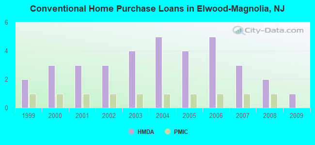
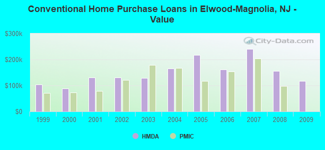
| Home Mortgage Disclosure Act Aggregated Statistics For Year 2009 (Based on 1 partial tract) | ||||||||
| A) FHA, FSA/RHS & VA Home Purchase Loans | B) Conventional Home Purchase Loans | C) Refinancings | D) Home Improvement Loans | |||||
|---|---|---|---|---|---|---|---|---|
| Number | Average Value | Number | Average Value | Number | Average Value | Number | Average Value | |
| LOANS ORIGINATED | 1 | $246,070 | 1 | $116,970 | 7 | $203,080 | 1 | $101,580 |
| APPLICATIONS APPROVED, NOT ACCEPTED | 0 | $0 | 0 | $0 | 1 | $194,810 | 0 | $0 |
| APPLICATIONS DENIED | 0 | $0 | 0 | $0 | 4 | $179,818 | 1 | $75,120 |
| APPLICATIONS WITHDRAWN | 0 | $0 | 0 | $0 | 2 | $201,065 | 0 | $0 |
| FILES CLOSED FOR INCOMPLETENESS | 0 | $0 | 0 | $0 | 1 | $99,940 | 0 | $0 |
Detailed HMDA statistics for the following Tracts: 0107.00
| Private Mortgage Insurance Companies Aggregated Statistics For Year 2008 (Based on 1 partial tract) | ||
| A) Conventional Home Purchase Loans | ||
|---|---|---|
| Number | Average Value | |
| LOANS ORIGINATED | 1 | $97,180 |
| APPLICATIONS APPROVED, NOT ACCEPTED | 0 | $0 |
| APPLICATIONS DENIED | 0 | $0 |
| APPLICATIONS WITHDRAWN | 0 | $0 |
| FILES CLOSED FOR INCOMPLETENESS | 0 | $0 |
Detailed PMIC statistics for the following Tracts: 0107.00
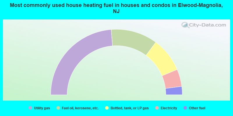
- 47.4%Utility gas
- 22.9%Fuel oil, kerosene, etc.
- 17.0%Bottled, tank, or LP gas
- 8.5%Electricity
- 4.1%Other fuel
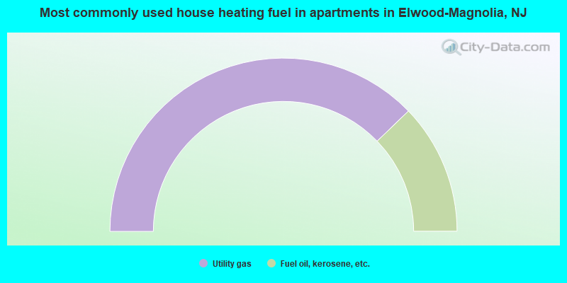
- 75.6%Utility gas
- 24.4%Fuel oil, kerosene, etc.
Elwood-Magnolia compared to New Jersey state average:
- Median house value below state average.
- Unemployed percentage below state average.
- Median age below state average.
- Foreign-born population percentage significantly below state average.
- Renting percentage significantly below state average.
- Length of stay since moving in significantly above state average.
- Number of rooms per house significantly below state average.
- House age significantly below state average.
- Number of college students below state average.
- Percentage of population with a bachelor's degree or higher significantly below state average.
Elwood-Magnolia on our top lists:
- #37 on the list of "Top 101 cities with the largest percentage of people in homes for the mentally ill (population 1,000+)"
- #1 (08217) on the list of "Top 101 zip codes with the largest percentage of Swedish first ancestries"
- #11 on the list of "Top 101 counties with the lowest Sulfur Oxides Annual air pollution readings in 2012 (µg/m3)"
- #18 on the list of "Top 101 counties with the highest number of infant deaths per 1000 residents 2007-2013 (pop. 50,000+)"
- #34 on the list of "Top 101 counties with the largest number of people moving out compared to moving in (pop. 50,000+)"
- #42 on the list of "Top 101 counties with the lowest percentage of residents relocating from other counties between 2010 and 2011 (pop. 50,000+)"
- #49 on the list of "Top 101 counties with the largest decrease in the number of deaths per 1000 residents 2000-2006 to 2007-2013 (pop. 50,000+)"